QUITO

@rivescohomes

@rivescoconstructora
@rivescohomes
@rivescoconstructora

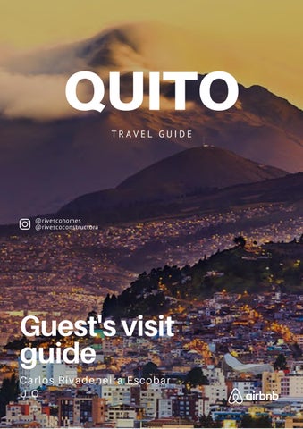
Quito was the first city to be declared a UNESCO World Cultural Heritage Site, and it is located in the Andes Mountains. The city is surrounded by twelve volcanoes, among them: Pichincha, Cotopaxi, Antisana, Cayambe, which form a majestic Andean contour. The historic downtown of Quito is probably the largest in Latin America, not only for its size but also for the architectural monuments it contains.
Quito is the second highest capital city in the world at 2830 meters above sea level. It has an area of 4,183 km² and about 2.2 million inhabitants. Quito's climate is variable, with temperatures that can range from 77 Fahrenheit during the day to 50 Fahrenheit at night, and it is common to have heavy rains, low temperatures and bright sunshine in the same day. It is advisable to bring warm clothes, even on sunny days.

....
In general, all the tourist attractions in the historic downtown are within short walking distance of each other. You have to be prepared for all the ups and downs of Quito's streets, and walk them calmly, since, being a city located at high altitude above sea level, you can suffer altitude sickness (headache, vomiting, discomfort).
Getting around Quito by public transportation, there are three integrated services: the Metrobus Q, the Ecovía and the Trolebus. All three systems run longitudinally through the city, that is, from north to south and vice versa. All of them pass through or near the historic downtown. It is advisable not to use electronic devices (cell phones, tablets, cameras) on public transportation, as there are certain areas where you should be careful.


In order to please our guests, we are available for any questions, comments or requirements.
If you need any advice about what places to visit contact us via Whatsapp or Telegram.
Besides, we organize personalized tours to tourist places inside and outside the city and transfers to the airport or other cities .Please contact us to know about the prices of any of these services.
MAIN CONTACT:
Carlos Rivadeneira Escobar
+593 98 254 1892
csg1d30@hotmail.com
Super mini Universal
Fruits, milk, drinks, snacks, and more.
Distance: 50 meters
Google Maps:
https://goo.gl/maps/waAdQqTmgowP
YVwVA
Supermercado Don Vic
Fruits, milk, drinks, snacks, and more.
Distance: 140 meters
Google Maps:
https://goo.gl/maps/A8sLi4k1nRRw3Z
WD6
Pharmacy’s
Distance: 250 meters
Google Maps:
https://goo.gl/maps/voWXdbbhdWKj2
p3i6
Fybeca
Distance: 140 meters
Google Maps:
https://goo.gl/maps/6kzrqfH6c73Gmn
Tr6
Medicity
Distance: 300 meters
Google Maps:
https://goo.gl/maps/RD55rL9K2ULR5

ZkXA
Juan Valdez Café
Distance: 220 meters
Google Maps:
https://goo.gl/maps/LbGQtwE5yEC uoP37A
Sweet & Coffee
Distance: 220 meters
Google Maps: https://g.page/sweetandcoffeegonzalezsuarez?share
Hansel & Gretel
Distance: 270 meters
Google Maps:
https://goo.gl/maps/4rpcwLVutKfZzP gw6
El Español
Distance: 50 meters
Google Maps:
https://goo.gl/maps/qgZzMnBZn5cE7
FK88
Hot Dogs de la González
Suárez
Distance: 500 meters
Google Maps:
https://goo.gl/maps/dSms9JzSb3oMa
grH7
Pizzería El Hornero
Distance: 500 meters
Google Maps:
https://goo.gl/maps/G6WKoS7GKyyp
KsmU7
Casino
Disco
Distance: 650 meters
Google Maps:
https://goo.gl/maps/AZQcYFvFgVy1R
CDD9

Ciré Capital
Variety of dishes
Distance: In the entrance of the building
Google Maps:
https://goo.gl/maps/kEWgZbWhb2cSi 8Kr9
Pezbela
Seafood
Distance: 400 meters
Google Maps:
https://g.page/pezbela?share
L’Arcadia
Pasta
Distance: 400 meters
Google Maps:
https://goo gl/maps/dAd9hWq9dM79
Tyv58
Whymper Street
Traditional craft beer street. Distance: 650 meters
Google Maps:
https://goo.gl/maps/yxBPztCKK5WNT
CQK9

The Historic Downtown of Quito is the largest heritage site in Latin America, containing about 130 monumental buildings and more than 5,000 properties registered as historical heritage. The Historic Downtown has about 17 museums and 24 churches, convents and monasteries.

If you have time and like walking, we recommend you to walk along Garcia Moreno Street, also known as "Street of the 7 crosses " , from the Basilica of the Voto Nacional to La Ronda Street. On this route, you will be able to see all the fascinating old architecture of the city, as well as most of its emblematic buildings.
Google Maps:
https://goo.gl/maps/GQHGd3dvPRTh Qctk8
Basilica del Voto Nacional is the most important artwork of Ecuadorian neo-gothic architecture and one of the most representative of the American continent, being the largest in the New World (America). For its structure and style, it is compared with two of the great cathedrals of the world as St. Patrick's Cathedral in New York and Notre Dame in Paris. Most of the animals that decorate the church are not mythological, but are a sample of the endemic and exotic Ecuadorian fauna. The first stone of the church was laid around 1890, and its construction lasted approximately 100 years.
You can climb the towers of the church by buying a ticket at the entrance. There are restaurants and handicraft stores at the top of the church. Don't miss the views from the towers.


https://goo.gl/maps/A3XBkN8YMr8G bcXy7
Google Maps: U

The Cathedral of Quito is an orthodox style building, which serves as the seat of the Archbishop. It is one of the oldest churches in South America, built between 1562 and 1565. It presents a mixture of styles such as baroque, mudejar, rococo, neogothic and neoclassic. It houses a large sample of art, painting and sculpture of great artists of the colonial and republican era.
You can enter in the interior of the cathedral, as well as climb the domes to observe the Historic Downtown.

Google Maps:
https://goo.gl/maps/xosQEoztfyS9zWha9


The Church and Convent San Francisco is an impressive monument of Quito's Franciscan heritage. The site consists of a temple, several chapels and a convent. The 16th century complex covers almost two blocks of Quito's Historic Downtown. The foundations were laid shortly after the Spanish conquistadors founded the city. In recent times, it was found that the church and its plaza were built over an ancient Inca temple.
San Francisco Church treasures a great variety of artistic manifestations that are made with different techniques. It has been counted that San Francisco has 3,500 artistic pieces of the colonial era.
https://goo.gl/maps/EEYyJznB4f5RW snM9
Google Maps: U I O | 1 2

La Compañia de Jesus church is the crowning artwork of the architectural style known as baroque in Latin America, and it is known as the Jewel of America. The construction begun in 1605 and, it took 160 years to be completely finished. The church, and its rich internal ornamentation, entirely covered with gold leaf, is one of the city's major tourist attractions and an invaluable heritage, both artistically and economically, for the country.

Google Maps:
https://goo.gl/maps/FPu9CfVwjWC
ENbyv7
Carondelet Palace is the seat of government and official residence of the President of the Republic of Ecuador. In colonial times, it was the seat of the Spanish government in the Real Audiencia of Quito. Reformed by Baron Luis Héctor de Carondelet, president of the Audiencia at the end of the 18th century, it received its name when Simon Bolívar visited the building after the independence of 1824 and began to call it this way, amazed by the good taste of the baron.


Google Maps:
https://goo.gl/maps/ybu9wRJyaoyi Ri6AA
La Ronda Street is one of the oldest and most traditional streets in the Historic Downtown of Quito. It is a bohemian site of cafes, art, restaurants, sounds and flavors that are enjoyed both by Quiteños (people from Quito), as well as by people visiting the city. This is definitely a must-see place to visit in Quito. It was also a cradle of painters, writers and poets in the 1930s.
It is believed that its original name was "El Chaquiñán", a term that is now translated as road or path. It is presumed that this small street was already established and laid out around 1480, when the Incas arrived in Quito.


Google Maps:
https://goo.gl/maps/2KUwB7QuGKe rzjhb8
City Museum was inaugurated in 1998. It is located in the facilities of the old San Juan de Dios Hospital, an institution that operated from 1565 to 1974, which makes it one of the oldest civil buildings in the city, since it contains 452 years of history, patrimony and identity. In its interior is exhibited the history of Quito, in addition to the history of the 400 years of operation of the hospital.


Google Maps:
https://g.page/museociudaduio?share
The Wax Museum has a permanent exhibition entitled "From Quito to Ecuador (17361830)". This exhibition covers several important chapters that took place in the city of Quito.


Google Maps:
https://goo.gl/maps/YZi8RjggVhWxAv ma8
Located in the Historic Downtown of Quito, La Plaza Grande is the meeting point of the Quiteños, who nostalgically remember past times. The Plaza Grande is composed of four buildings that represent the estates of Quito's society such as The Presidential Palace, the Archbishop's Palace, the Cathedral of Quito and the Municipal Palace.


In the center of La Plaza de la Independencia, we find the monument to the Heroes of Independence that was built in the early twentieth century, which symbolizes the triumph of the republic against the Spanish colony.
Google Maps:
https://goo.gl/maps/MWsVhBv38GVg3 9L37
El Panecillo is a natural elevation of 3,000 meters above sea level; it was baptized with this name because of its resemblance to a small loaf of bread. It is located in the heart of the city of Quito. Because of its location, it has become the most important natural viewpoint of the city, from which you can see the urban layout of the capital, from its historic downtown and to the north and south ends.
El Panecillo is currently crowned by a giant aluminum sculpture of the "Virgin of Quito", which was based on the Virgin of “Legarda” or “Apocalyptic”. The majestic “Virgin of Quito” is the largest aluminum representation in the world and ranks 58th among the tallest images in the world.


Google Maps:
https://goo.gl/maps/18DXSLDrBPiq
oA44A
In Guápulo, you can enjoy a surprising combination of art, history and landscapes. Located north of downtown Quito, Guápulo is known as the bohemian area of the city. Indeed, it is a peaceful place. For a typical day here, you can walk around along the quiet cobblestone streets, visit galleries and craft stores, people-watch from a café terrace, and relax in a beautiful urban park. Take a walk along the "Camino de Orellana" street, where you can find bars and cafes frequented by artists, poets and musicians.
In the center of Guápulo, it is its central historical monument, the great "Sanctuary of Guápulo" from colonial times. It was the first Marian sanctuary of the Republic of Ecuador founded in 1620.


Google Maps:
https://goo.gl/maps/FPNrUKxp8KGPJ mg9A
It is one of the most important green areas of the city of Quito and with its 64 hectares, allows a great space for relaxation: here you can picnic, ride a bike, sail in the lagoon, visit the Botanical Garden and the Vivarium or taste a delicious cotton candy.

Around the park, on Avenida
De los Shyris and Avenida
República del Salvador, you can appreciate Quito's modern architecture, as the park is located in the financial and most modern area of the city, with new, high-rise buildings.

Google Maps:
https://goo.gl/maps/wphuQAFVQGL
xeowW6
The trip on the TelefériQo of Quito is a unique experience that unveils new sensations each time. The view, as you ascend, reveals a unique landscape of the city and the opportunity to travel more than 2,500 meters in less than 20 minutes to discover places of amazing beauty.


Google Maps:
https://g.page/TeleferiQo?share
The Middle of the World is an iconic site in Ecuador, as the country takes its name from the Equatorial Line, an imaginary line that divides the planet into northern and southern hemispheres. Today, it is a very significant tourist attraction for the city. It is also the opportunity to take pictures of you in both hemispheres at the same time, level an egg on a nail without needing to hold it, etc.


Google Maps:
https://goo.gl/maps/XujVdbQzaxpD 33QQ7
The Pululahua has the category of "Geobotanical Reserve". It is a protected area in the north of Quito, and it is the habitat of a great diversity of fauna and flora. The Pululahua is located on top of an active volcano, which is why it has great mineral wealth and therefore its lands are very fertile and productive.


Google Maps:
https://goo.gl/maps/Ps6JK7jUnYpnW smz6
In the heart of Cumbaya Valley, it is its central park, which is surrounded by the Church of San Pedro de Cumbaya and a lot of bars and restaurants located in the surrounding streets. It is an ideal place if you want to spend an unforgettable evening out and at the same time close to the city.


Google Maps:
https://goo.gl/maps/YAwJGwdyVxc
7bfXG9
The ecological route "El Chaquiñán" is a natural space where people can travel along the old railroad track, on foot or by bicycle, along a dirt road surrounded by ecosystems of the area.


Google Maps:
https://goo.gl/maps/S7xfvpGCACByY wSW9
The Pita waterfall has an approximate height of 60 m. It is born from the thawing of the Cotopaxi and Sincholagua volcanoes. For this reason, when entering its waters you feel the deep cold that reaches the bones, but at the same time, it generates a sense of peace.


Google Maps:
https://goo.gl/maps/uptXEN4D7i6J
ZMKYA
This refuge is located 90 minutes from downtown Quito. It is a natural place surrounded by waterfalls, springs, eucalyptus trees and much more. Several trails with stones, earth, water and rustic wooden stairs lead to the waterfall that baptizes the reserve.


Google Maps:
https://g.page/molinucoecuador?share


 Termas de Papallacta
Laguna de Mojanda
Parque Nacional Cotopaxi
Termas de Papallacta
Laguna de Mojanda
Parque Nacional Cotopaxi


Handmade backpacks
Handmade backpacks with tribal designs


$20.00