
FIRST & GRANDVIEW DISTRICT PLAN
Timeless Charm, Modern Vision
Acknowledgments
Resident Participants
Jennifer Abbruzzese
Teri Alexander
Susan Allardyce
Ben Anthony
Tim Armstrong
Ashley Barone
Brad Bauer
Zach Bickett
Sandra Binning
Elizabeth Bockbrader
Daniel Boulton
Ian Bowman-Henderson
Thomas Burgess
Cindy Byington
Maria Cantrell
Austin Carter
Jim Clark
Laurie Clark
Sheila Clark
Katie Clifford
Tracey Coe
Rich Collins
Justin Cook
Marissa Deerwester
Melissa DeGraw
Spencer Dunaway
Lauren Edwards
Chris Enderle
Cori Evans*
Nickie Evans
Jeff Ferriell
Nathan Fisher
Audrey Foster*
Hiram Foster*
Joy Frank-Collins
Tim Freeman
Ashley Furno
David Geiger
Cheryl Hacker
Timothy Hawk
Kristin Henkaline
Gary Heydinger
Collin Hill
Aaron Hoffmans
Heather Kerr
Lauren King
Rick Kinsinger
Chelsea Konieczko*
Kristopher Konieczko
Joe Kubina
Simiao Li-Sauerwine
Ryan Linville
Brandon Lynaugh
Stephen Lyons
Susan MacLeod
Manda
Mary McCarron
Ryan McDonnell
Jonathan D McKay
Mark Mederski
Courtnee Mueller
Robert Newbury
Nathan Osborn
Kelly Poe
Kevin A Richards
Matt Roby
Anthony Roth
Laura Roth
Mike Rowland*
Kerry Ruberg Hyre
Luke Russell
David Schmied*
Sara Schroeder
Eric Schweinhagen
Robert Shevlin
Eleni Shipp*
Debbie Sisinger
John Sisinger
Dan Skinner
Ewa Sletten
Andrew Smith
Michael Staff
Kevin Stanek
Tara Stottlemire
Steve Sutters*
Rick Szabrak*
Drew Todd*
Juan Torres
Travis Ulmer
Allyson Vasu-Sarver
Molly Wassmuth
Chris Wager
Elizabeth Watters
Dan Weis
Dora West
Robert Zwink*
*Open House Volunteer
Stakeholders, Community Institutions
Destination Grandview
Grandview Heights Marble Cliff Historical Society
Grandview Heights Public Library
Grandview Heights Public Schools
Tri-Village Chamber Partnership
Stakeholders, Businesses
Eric Brembeck, Grandview Theater and Drafthouse
Abraham Hoellrick, Grandview Dental Care
Chelsea Konieczko, Vernacular
Robert Mackey, Robert Mackey CPA
Angel McLaughlin, Akada Salon
Ron Mohr, Mohr Wealth Management
John Myers, Myers Realty
Mark Swanson, Stauf’s
Diana Wang, Fine Feather
Adam Weimer, Spencer Research
Mirinda Witt & Colby, Doggie Day Spa
Stakeholders, Commercial Property Owners
Ryan Crossley
Jamie Gentry
Michael Kohr
Pat Kohr
Anjel McLaughlin
Bill Thompson
Dow Voelker
Jeff Wagenbrenner
Core Team
Greta Kearns, Mayor
Emily Keeler, City Council President
Anthony Panzera, City Council
Tim Kaskewsky, Planning Commission
P’Elizabeth Koelker, Director of Planning and Community Development
Allex Smith, Planning and Community Development Specialist
Aubrey Hale, Director of Administration
Megan Miller, Director of Finance
Darryl Hughes, Director of Service
Mike Patterson, Director of Parks & Recreation
Ryan Starns, Police Chief
Greg Eisenacher, Fire Chief
Christy Clark, Strategy and Engagement Manager
Consultants
Planning NEXT
REALM Collaborative
Table of Contents
Appendices (Separate Cover)
A. Streetscape Existing Conditions
B. Architectural Existing Character
C. Streetscape Studies
Executive Summary
Motivation
The First & Grandview District Plan establishes a 20+ year vision for the core of the Grandview Heights community. This vision is rooted in the reality of growth pressure facing the central Ohio region and the acknowledgment that this is a special part of the Grandview community and, therefore, needs special care. This planning effort has been an opportunity for the Grandview Heights community to gather to discuss and develop a vision for the future that will continue to enrich community life for generations to come.
The timing of this district plan is motivated by several factors including:
» Public infrastructure investment needs
» Updates to the Grandview Heights City Schools 4-12 Campus
» Newly designated City parkland in the district
» Grandview Heights Public Library upgrades, recently and in the future
» Land use character considerations (how and where to integrate residential and commercial uses most effectively in the district)
» Properties that are ready for investment and in need of future direction
» Aging building stock in need of reinvestment
» Development pressure as Columbus densifies at the district borders
» Competition from other regional business centers that have experienced recent investment in public infrastructure offering more amenities and options
Opportunities
A review of the existing conditions of the district revealed four areas that present opportunities for intervention. Opportunity areas include:
» Streets. The City of Grandview owns the existing right-of-way, this “site control” is crucial for the City’s ability to shape the future of how the streets function and feel. Given the lack of City-owned real estate in the study area, the streets have a role as the district’s public space.
» Private Development. The First & Grandview District is primarily built out and comprises small privately owned parcels, many of which are low density and in poor condition. Meanwhile, both residents and businesses value the mix of old and new, and express a preference for organic change over time rather than revolutionary rapid replacement. Given these conditions, phased redevelopment will be one of the
main ways to realize change in the district. One of the purposes of this plan is to signal the desired direction of long-term redevelopment to investors while giving decision-makers a tool to evaluate proposed projects as they come along to ultimately realize the vision set forth in this plan.
» Parking. Space within the district is limited, so parking must be maximized to ensure accessibility for all. Strategies to maximize existing parking should be pursued. This may include improving wayfinding and establishing flexible parking arrangements to utilize the available parking areas within the district.
» Education and Community Hub. A unique opportunity presents itself to strengthen the relationship between Grandview Heights Public Library and Larson Middle School. Realigning the library with the middle school could create a campus-like feel, establishing a strong and flexible community anchor on First Avenue.
Vision
The vision for the district is framed by the characterization of the area as being composed of:
» One District. The whole district should have an identity that is supported by legislation and an established character that sets it apart from other places within the City of Grandview Heights.
» Two Streets. Grandview Avenue and First Avenue are the armatures that structure the district, with Grandview Avenue being more regionally important and First Ave being central to the interconnected life of the community. The physical qualities and associated land uses inform each street’s differing character. Care should be given to strengthen each street’s qualities to establish authentic places that reflect how the people of Grandview envision the future of life on the streets within the district.
» Three Zones. The First & Grandview District can be further characterized by three zones based on the character and existing land use found throughout the district. The northern part of Grandview Avenue is characterized as the “Destination Zone”; the restaurants and social nature of the semi-public space give this area its character. The “Lifestyle Zone” wraps around the corner of Grandview Avenue
and First Avenue, this zone is made up of professional and everyday businesses that serve the needs of the Grandview community. The western portion of First Avenue is designated as the “Community Zone” based on the strength of community-oriented institutions, including the library and middle school. The variable nature of the three zones’ character contributes to the area’s eclectic feel while enabling a sense of discovery as one moves through the district.
» Four Sides. The First & Grandview District doesn’t exist in isolation from the rest of the Grandview Heights community. To ensure a smooth transition from the surrounding residential areas, consideration should be given to the scale of buildings at the district’s periphery. The inside of the knuckle (north of First Avenue and West of Grandview Avenue) is characterized by more robust existing development. In contrast, the outside of the knuckle (south of First Avenue and East of Grandview Avenue) is more residential in character.
Implementation
This plan is a crucial first step in establishing the direction for the future of the First & Grandview District. Further technical studies will be undertaken to examine the potential impact the vision outlined in this plan may have on the district and ensure infrastructure and financial models are in place to enact the proposed changes envisioned by this plan.
Specific studies to be completed include a parking analysis to inventory the existing parking within the district and project how land use changes may impact parking within and in proximity to the district. An economic analysis study will be undertaken to examine the expected economic impact of development on the area and explore funding mechanisms for public infrastructure work in the district.
After the necessary studies are complete, the City will be able to act in an informed manner to begin to draft guidelines and review the zoning standards within the district. These necessary policy tools will enable the City to codify the design and land use direction for the district to give shape to future redevelopment within the district.


INTRODUCTION
Introduction
Statement of Intent
The purpose of the First & Grandview District Plan is to support and extend this district’s authentic and charming character. Developing an intentional and complementary modern vision will enable needed and desirable incremental investments in public and private properties, which will become our enduring legacy for generations to come.
Motivation
The City of Grandview Heights is uniquely situated in the growing Central Ohio region. Grandview Heights is a small urban city with a population of 8,085 people (US Census 2020). Grandview Heights is known across the region for its quality schools, quaint small-town feel, and walkable business district.
As the region grows and changes, the First & Grandview District needs a vision to guide the course of development and change over the next 20+ years and ensure the community’s character is carried into the future.
The timing of this district plan is motivated by several factors including:
» Public infrastructure investment needs
» Updates to the Grandview Heights City Schools 4 - 12 Campus
» Newly designated City parkland in the district
» Grandview Heights Public Library upgrades, recently and in the future
» Land use character considerations (how and where to integrate residential and commercial uses most effectively in the district)
» Properties that are ready for investment and in need of future direction
» Aging building stock in need of reinvestment
» Development pressure as Columbus densifies at the district borders
» Competition from other regional business centers that have experienced recent investment in public infrastructure offering more amenities and options

Why Plan?
This plan establishes the vision for the First & Grandview District for the next 20+ years. It is crucial to have a longterm vision to guide future investments as opportunities arise over the next several decades. This plan imagines the evolution of both public and private space. The strategies put in place will guide long-term capital investment in public serving infrastructure. Visions of redevelopment are meant to convey desirable forms of development to potential private investors.
“First life, then, spaces, then buildings – the other way around never works.” -Jan Gehl
Redevelopment of parcels in the district is anticipated to be initiated predominantly by land owners as their property use needs change over time. The City’s role will predominantly be to spearhead the public infrastructure and utility upgrades to enhance the public realm, and to appropriately attract and incentivize private investment in order to realize the community’s vision over time. The ambition of this planning effort has been to capture the community’s vision for the authentic evolution of this
heart of Grandview Heights to leave as their legacy for generations to come.
Planning Approach
Community is at the core of this planning effort. A quote by Danish architect Jan Gehl gets at the heart of this district plan “First life, then, spaces, then buildings – the other way around never works.” This way of thinking guided the approach to the planning process, Leading with the
Grandview Avenue (Looking West)


quality of life desired within the district, motivating the desired public and gathering spaces within the district, and finally complementing with buildings and private development that support this vision.
Community Engagement Process
Community engagement is the foundation on which this plan stands. Multiple groups and perspectives informed the plan through 25 meetings. Input was gathered and incorporated from the following groups:


» Civic Core Team. City of Grandview staff from multiple departments, along with members of the City Council and Planning Commission, were involved at critical points throughout the planning process.
» Stakeholder Groups. Meetings were held at the outset and toward the end of the process to gather key insights from institutions, business owners, residents, and civic groups.

» Community Engagement Group. This group was engaged initially and midway through the process to help get the word out to the greater Grandview community.
» Public. Four open houses served as cornerstones for the plan. Public input was continually invited and incorporated through various activities and opportunities for engagement throughout the
planning process, both in person as well as through written feedback and by utilizing digital engagement tools on Growing Together. The integration of feedback into the vision for the district created a positive feedback loop between community meetings and establishing a direction for the vision, helping to establish trust and community understanding of the process.
Stakeholder Group Discussion
Civic Core Team
Engagement Group
Open House 2
Open House 4
Historical Context
Beginnings of a District
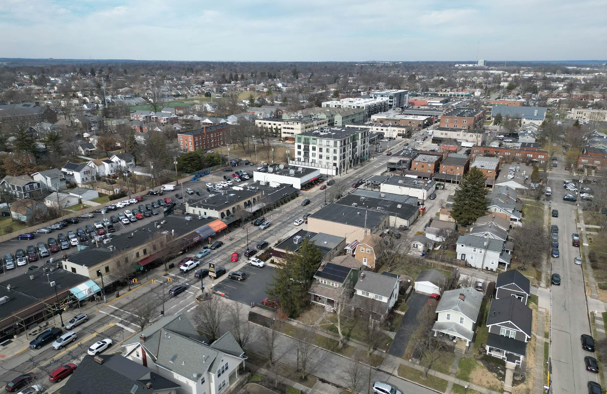
Throughout the early twentieth century, much of the commercial development in Grandview Heights revolved around the intersection of W First and Oakland Avenues. Just past the Grandview Heights city boundary, Oakland Avenue nearly aligns with N Star Avenue; together, these two streets form a central connection through the Tri-Village area, which may further indicate why the First & Oakland area was the original ‘downtown’ for Grandview Heights. Surrounding this important node were supermarkets, shops, and businesses. As the city grew through the early 1900s, First Avenue remained a valuable street for the town; the location of many parades and festivals, First Avenue was also a route for the Tri-Village Trolley, a streetcar that connected the growing neighborhood to downtown Columbus and Marble Cliff.
Masonic Building
In 1922, the Masonic Building was constructed at the corner of W First Avenue and Grandview Avenue. Home to the Masonic Temple, the building also housed Richwine’s Grocery Store, Koch’s Drug Store, and the Grandview Hardware Company. Over time, the Masonic Building became the connection point of two of the city’s most important streets.
Bank Block
Shortly after, in 1927, Grandview Avenue transformed with the addition of the Bank Block, built by real estate developer Casto. Filled with stores, this new development was one of the first shopping centers in the region. Through the years, the Bank Block has been home to countless businesses and establishments beloved by the Grandview Heights community. Known for its walkable nature and quaint store fronts, the Bank Block grew the commercial character of the city from W First Avenue around the corner to Grandview Avenue.

Unified District
These three developments define the First & Grandview District—First and Oakland at one end, the Bank Block at the other, and the Masonic Building as the anchor point in the middle. To enhance and extend the community character, The First & Grandview District Plan focuses on strategies for filling in the gaps between these three nodes and creating one cohesive district that captures the heart of Grandview Heights.
This aerial photograph from the early 1950s is looking northeast at the intersection of First Avenue and Oakland Avenue. At the top of the photo is Edison school, before the addition was built on the south side, and before the multipurpose building was add ed to the north side. At the bottom left of the photo is the Trinity United Methodist Church, which moved to the current 5th and Cambridge location in 1951. At the bottom right is the former building which housed the Grandview Cycle Shop, and across Oaklan d is a filling station; both properties now serve the Grandview Library. Across First from those buildings are a vacant lot that was a filling station, and the Gaudieri Cleaners building, which was later occupied by the Celeste realty company. Glass Plumbing, the business with the longest continuous operation in Grandview, occupied the building on First

Edison school
1st and Oakland Avenue aerial, early 1950s Source: Grandview Heights/Marble Cliff Historical Society (GHMCHS)
Bank Block Panorama, 1929 Source: GHMCHS
Citizen’s Trust Bank
Hamill’s Pharmacy
Kroger Grocery
Frank P . Hall Hardware
Grandview Market
Piggly Wiggly


Grandview Heights/Marble Cliff Historical Socie
Hinterschied s Grocery

Grandview Heights/Marble Cliff Historical Society
The facelift of Grandview Avenue at the Bank Block was underway in 1977, with the installation of the framework for the orange stripe canopy to be to be installed. The planting of trees and other landscaping along the sidewalk were the finishing touchesthe Grandview Parks and Recreation Department played a major part in the installation of the red maple trees. Six cuts in the sidewalk along the Bank Block were made to contain the trees and additional plantings. The colorful awnings would add to the front of the buildings for a new awakening of the retail complex. The Bank Block building was purchased in the spring by Wagbros Co. from a trust managed by a Cadiz, Ohio church. Following work to correct a bulging front wall in the building, the facelift project was started. The Bank Block is now listed on the Historical Register and has evolved into a thriving business community with sidewalk cafe appeal. The heritage of this Bank Block reaches back to 1927.

Submitted to ThisWeek Tri-Village News for publication on October 15, 2014
The commercial and social focus of the Grandview Heights community switched from First Avenue to Grandview Avenue after the competition of the Grandview Bank Block in 1927. In close proximity there were three grocery stores, a bank, drug stores, a movie ghmchs.org
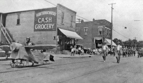
The Field Day Parade proceeds along the trolley tracks headed west on First Avenu front of Hinterschied’s Grocery at the corner of First and Oakland. Originally Arnold’ Grocery, which opened in 1895, it became Collins Grocery in 1904 and was purcha by Hinterschied in 1906 and expanded into a general store. The building on the opp corner is the old Gutches Market (Gaudieri’s Cleaners). The first fire equipment in Grandview Heights was a two-wheeled horse drawn cart that was housed in Hinterschied’s building. On its first run in 1906, it was called to a fire on the east
Grandview Avenue. When it arrived at the hydrant to hook up the hoses it was discovered that the threads on the hose were the reverse of those on the hydrant, a the volunteers were unable to attach it, and the house burned to the ground. It is tho
Grandview Avenue, 1948 Source: Grandview Heights/Marble Cliff Historical Society (GHMCHS) Outdoors Store, established in 1934 Source: GHMCHS
Masonic Hall Building, chartered in 1922 Source: GHMCHS
Field Day Parade moving west on 1st Ave at the intersection of Oakland Ave Photo taken in mid/late 1910s Source: GHMCHS
Outdoor dining and seating at Gourmet Market (1981), predecessor to Spagio (1993) . Image source: GHMCHS
Bank Block streetscape renovation, 1977 . Source: GHMCHS
High school students at Long’s Drugstore on Grandview Avenue, 1947 Source: GHMCHS

DISTRICT ANALYSIS
District Analysis
Analysis Shared through Community Engagement
A series of community engagement events and activities grounded the technical analysis. The first open house asked community members to walk through the district, analyzing the everyday spaces with a new lens toward what could be instead of what already is. Character imagery was used to initiate a reaction to the possible futures desired for the district. This first open house was crucial in setting the tone for the work to follow and generating excitement for the district’s potential.
Initial Analysis
To understand the dynamics and spatial phenomena at play within the district, an initial series of analytical diagrams was created to uncover the underlying features and patterns within the district.
These diagrams include:
» Property Ownership
» Open Space
» Retail Activation
» Parking Locations
» Walkability
» Mobility and Transit
» Land Use and Zoning
» Physical and Visual Analysis of the District
» Architectural Analysis

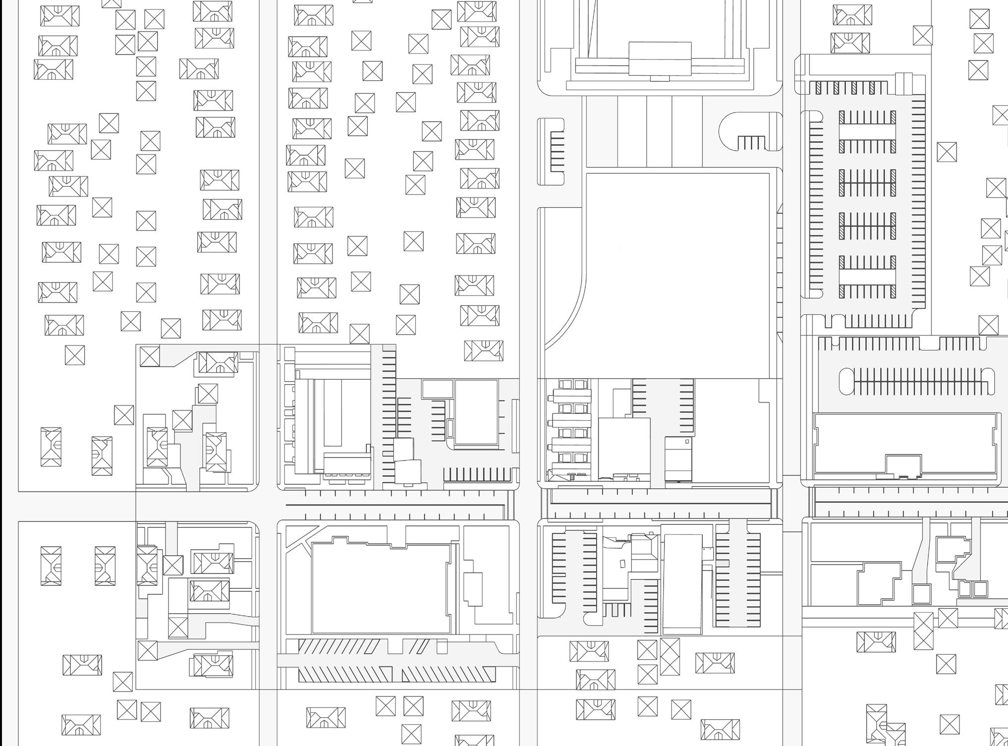
Property Owners
PROPERTY OWNERS
Takeaway
» Private development is a key component of the district. Private development is a key component of the district. Various property owners on small lots will shape how the district develops. Guidelines for this development will be needed to inform how the area develops such that a coordinated vision is achieved organically over time.
» The City of Grandview has limited ownership of land outside of the right-of-way. Public realm improvements will be focused on the roads and sidewalks. The City will also play a role in the reorganization of space within the Community Zone through its parkland near the schools and library.

CITY BOUNDARY
PRIVATE OWNER
CITY-OWNED
GVH PUBLIC LIBRARY
GVH SCHOOLS
in planning for municipal facilities (police, fire, administration, meeting spaces), recreation and open space amenities, and to identify opportunities for continued enhancement of the city’s civic realm.
Open Space
OPEN SPACE
Takeaway
» Public space, in particular, green space is lacking. Public space can be found near the school and library, but no public space is available on Grandview Avenue in the district’s core.
The Civic Spaces and Places Plan identifies three primary “civic hubs” within the community. Each of these hubs are uniquely addressed in the plan, highlighting their assets, urban characteristics, and potential opportunity areas.
» There is a strong relationship between Grandview Heights Public Library and the Middle School. The 2019 Community Plan calls for the establishment of a hub based on this relationship.
The details of these development options and specific recommendations can be referenced in the Civic Spaces and Places Plan, which has been incorporated in to this plan by reference.
Map 7-1: Civic Framework Map identifies the locations of these hubs in addition to the city’s parks and open spaces.
MAP 7-1: CIVIC FRAMEWORK MAP
City of Columbus
Source: 2019 Community Plan. Civic Framework Map (p. 64)
Ground Floor Retail and Commercial
RETAIL ACTIVATION (GROUND FLOOR)
Takeaway
» The character of retail and commercial space is variable. Grandview Avenue is home to destinationbased retail, whereas First Avenue is oriented toward serving the lifestyle needs of the community, including more small, entrepreneurial and servicebased businesses.
LEGEND
CITY BOUNDARY
STUDY AREA
PUBLIC SERVICES
VACANT
OFFICE / SERVICES
DINING / BARS
SHOPPING / ACTIVITIES
BEAUTY / HEALTH
City of Columbus
City of Grandview Heights
PARKING

ANALYSIS
First Avenue Street Parking: 66 Spaces
Grandview Avenue Street Parking: 60 Spaces
Total Street Parking Count: 126 Spaces
Total Surface Parking Count: 775 Spaces
Total Parking Count: 892 Spaces
Takeaway
» Parking is fragmented and in need of wayfinding improvements. Further analysis is needed to determine the existing parking utilization to establish baseline conditions for the district as it grows.
Walkability
PARKING PROXIMITY
Takeaway
» The district is walkable. One of the strengths of this district is its walkable nature.

CITY BOUNDARY LEGEND
Mobility + Transit
MOBILITY + TRANSIT
Takeaways
» Transit connections exist within the district. The district is connected to the COTA bus network, providing connections to this district and the greater Columbus region.
» First Avenue connects the community. The street serves as the primary east-west corridor connecting the neighborhoods with the First & Grandview District.
» The biking network lacks definition within the district. The 2019 Community Plan calls out 2nd Avenue as a proposed bicycle boulevard, while First Avenue acts as a shared roadway for bikes and cars (see 2019 Community Plan inset to the right). Consideration should be given to how biking is safely incorporated within the district.
Source: 2019 Community Plan Transportation Recommendation Map (p. 49)
Zoning Foundation
LAND-USE + ZONING
Takeaways
» Zoning sets up a variety of uses within the district. The variability of uses helps create an eclectic feel to the district but can create moments of tension between adjacent uses.
» The existing overlay establishes the legal groundwork for the district plan. The existing overlay district establishes only a part of the district (Grandview Avenue) as a place with specific standards which act to guide development. This results in a non-cohesive pattern for the remainder of First Avenue.
LEGEND
GRANDVIEW
AVENUE OVERLAY DISTRICT (GAOD) CITY BOUNDARY
LIMITED COMMERCIAL (C-1)
NEIGHBORHOOD COMMERCIAL (C-2)
NORTHEAST
ASHLAND / FIRST OVERLAY DISTRICT (NAFOD)
PARKLAND (P)
PLANNED COMMUNITY DISTRICT (PCD)
RESIDENTIAL
SINGLE (RS-1)
RESIDENTIAL
SINGLE (RS-2)

First Avenue Streetscape Analysis
First Avenue plays a critical role in connecting the Grandview community. First Avenue connects the civic foundations of the community to the neighborhoods. The street plays host to a mixture of small businesses enhancing the eclectic feel of the district, playing a large role in how the community views itself.
Challenges
» The roadway is primarily dedicated to vehicles. 40’ of 60’ right-of-way is dedicated to vehicles.
» Pedestrians must cross extended stretches of roadway. The typical crossing distance of 40’ results in longer periods of vehicular exposure for pedestrians as they cross the street.
» The sidewalk widths are minimal, and they do not accommodate groups traveling to and from the school or library.
» Lack of provision for multi-modal transportation. First Avenue lacks infrastructure to support transit users, bicyclists, and other forms of non-vehicular travel.
» Lack of robust tree canopy. Trees are sparsely planted along the street corridor.
» On-street parking is poorly marked. Uncertainty in parking can lead to the perception of a lack of available parking.
» Overhead power lines prevent tree planting. Infrastructural constraints limit potential streetscape changes.
Findings

» Variety is the defining factor. The street is defined by an eclectic mixture of building types and public/private pedestrian-oriented spaces. Buildings’ setbacks vary, creating a variable pedestrian experience, with some instances being more comfortable than others.
» The Right-of-Way is an asset. The existing rightof-way serves one lane of traffic moving each direction. Given the public nature of the roadway, the City has some flexibility in how it would like to designate the right-of-way in the future to retain a functional roadway while enhancing the pedestrian realm.
FIRST AVENUE EXISTING STREET CONDITIONS
First Avenue Existing Street Conditions
NOTES:
1. 40’ EXISTING ROADWAY WIDTH FROM CURB TO CURB
2. EXISTING OVERHEAD POWER LINES ON SOUTH SIDE OF STREET
3. LIMITED AREAS FOR TREE PLANTINGS IN EXISTING R.O.W. CONFIGURATION

CHALLENGES:
1. ROADWAY WIDTH IS DEVOTED TO VEHICLES, 40’ ROADWAY IN 60’ ROW
2. CROSSINGS AT INTERSECTIONS ARE 40’ IN LENGTH, COULD BE REDUCED
3. SIDEWALK WIDTHS ARE MINIMAL, DO NOT PROVIDE FOR GROUPS GOING TO SCHOOL OR LIBRARY
4. NO CONSIDERATION FOR A MIXTURE OF TRANSIT USES (BUS, BICYCLE, SCOOTER, ETC.)
5. MINIMAL TREE CANOPY, TREES SPORADICALLY PLANTED
6. ON STREET PARKING ZONES ARE NOT CLEARLY IDENTIFIED / MARKED
7. OVERHEAD POWER LINES ON SOUTH SIDE PREVENT SIGNIFICANT TREE PLANTINGS


Grandview Avenue Streetscape Analysis
Grandview Avenue is the heart of the City. It is a regional destination for dining and leisure, it is a place for the Grandview community to come together and socialize. The road also connects the densifying City of Columbus to the north with I-670 to the south.
Given the street’s dual nature as a pedestrian destination and a vehicular thoroughfare, the allocation of space between cars and people is a point of tension and, in some instances, a question of safety.
Challenges
» The roadway is primarily dedicated to vehicles. 46’ of 60’ right-of-way is dedicated to vehicles.
» Pedestrians must cross extended stretches of roadway. The typical crossing distance of 46’ results in longer periods of vehicular exposure for pedestrians as they cross the street.
» The sidewalks are not fully accessible. Segments of the sidewalk need to be repaired and widened to maintain or create ADA accessibility.
» Sidewalk space is constrained. Sidewalks lack space to accommodate all of the streetscape needs, including infrastructure, amenity areas for socialization, and space for people to move comfortably along the street.
» There is minimal provision for multimodal transportation. Grandview Avenue lacks infrastructure to support transit users, bicyclists, and other forms of non-vehicular travel.
» Lack of robust tree canopy. Trees are sparsely planted along the street corridor, limiting shade and contributing to a harsh pedestrian experience.
» On-street parking is poorly marked. Uncertainty in parking can lead to the perception of a lack of available parking.
Findings
» Increase space for people. The existing conditions of Grandview Avenue neglect the pedestrian experience. Utilities and curb cuts are the primary offenders inhibiting smooth and safe travel along the street. Work needs to be done to bring order to the right-of-way and create a more accessible pedestrian environment throughout.
» Variety adds character. The horizontal scale of the building facades creates a comfortable rhythm of discovery as one moves along the street. The small size of the lots and building frontages contribute to the variable nature of the streetscape.
» Soften the street. The lack of tree canopy cover and limited open spaces along Grandview Avenue create a harsh and inaccessible environment for pedestrians as they make their way down the street. Consideration should be given to creating moments of relief along the street.
Grandview Avenue Existing Street Conditions
GRANDVIEW AVENUE EXISTING STREET CONDITIONS
NOTES:
1. 46’ EXISTING ROADWAY WIDTH FROM CURB TO CURB
2. BANK BLOCK SETBACK TO WEST ADDS ADDITIONAL SIDEWALK WIDTH
3. LIMITED WIDTH TO EAST SIDE OF STREET FOR SIDEWALKS AND TREE PLANTINGS
4. LIMITED AREAS FOR TREE PLANTINGS IN EXISTING R.O.W. CONFIGURATION

CHALLENGES:
1. ROADWAY WIDTH IS DEVOTED TO VEHICLES, 46’ ROADWAY IN 60’ ROW
2. CROSSINGS AT INTERSECTIONS ARE 46’ IN LENGTH, COULD BE REDUCED
3. SIDEWALK WIDTHS ARE MINIMAL, SOMETIMES NOT ADA COMPLIANT
4. SIDEWALK WIDTH DOES NOT ACCOMMODATE OUTDOOR DINING IN SOME AREAS
5. LITTLE CONSIDERATION FOR A MIXTURE OF TRANSIT USES (BUS, BICYCLE, SCOOTER, ETC.)
6. MINIMAL GREEN SPACE, NO CONSISTENT TREE CANOPY FOR SHADE
7. ON STREET PARKING ZONES ARE TOO ABUNDANT AND WIDE TO SUPPORT A PEDESTRIAN SCALED EXPERIENCE
8. MINIMAL SPACES TO SIT AND SOCIALIZE OTHER THAN PRIVATE RESTAURANT PATIO SPACES

Grandview Avenue Existing Conditions Analysis
1ST AND GRANDVIEW ANALYSIS
Composite District Analysis

Planning Framework PLANNING
Opportunities for Change
The initial analysis phase revealed a few types of space as opportunities for transformational change.
» Streets. Most of the publicly owned space in this district is dedicated as Right-of-Way for cars. opportunity exists to re-balance this space to better accommodate people rather than primary providing space for vehicles.
» Education and Community Hub. The 2019 Spaces and Places Plan outlined this area’s vision. This district plan aims to build on that work and realize the vision for a community hub anchored by the library and school.
» Private Redevelopment Opportunities. buildings, outdated uses (eg. single-family homes within a commercial center) and growth pressure will impact privately held land in the district. As development opportunities present themselves, the vision can help guide the form and function of these spaces while enhancing the district’s vibrancy.
» Parking. Parking is disjointed within this district. Future efforts to organize and consolidate parking should be pursued to add clarity and predictability.
CONSIDERATIONS


1 District, 2 Streets, 3 Zones, 4 Sides
CHARACTER ZONES
The establishment of the planning framework provoked further inquiry into the future character of the area and how the character may begin to be realized across the district. It was realized that the district is actually defined by two streets, with three zones and four sides. This area is not homogeneous. This eclectic character should be preserved in the future vision as it is important to the community.
The First & Grandview District is defined by the streets that run through it, Grandview Avenue and First Avenue, forming an L-shaped commercial and social center within the Grandview Heights community. Along this corridor exist three zones enhance the vibrancy that exists today, having evolved organically and both informing and aligning with the future vision. The four sides of variable adjacencies; consideration is needed to ensure future development is sensitive to existing land uses. The First & Grandview District is brought to life by the movement of people through public spaces to private destinations. An eclectic mixture of businesses in the heart of the community strengthens the publicprivate interface.

COMMUNITY ZONE
LIFESTYLE ZONE
DESTINATION ZONE
DESTINATION ZONE Existing Conditions

DESTINATION ZONE CHALLENGES
A. Better connection between Bank Block parking to future developments north of West 3rd Avenue needed
B. Long-term solution for parking lot at the corner of West 2nd Avenue and Grandview Avenue needed to enhance district character
C. Multitude of vehicular curb cuts create conflicts between cars and pedestrians along 1st Avenue and Grandview Avenue
D. Ability to reduce curb cuts by converting alleys into public space to enhance district
E. Lack of physical Gateway into the district from the North, necessary to coordinate with City of Columbus as perceived gateway
LEGEND
EXISTING CURB CUTS
EXISTING PARKING LOTS (PUBLIC & PRIVATE)
POSSIBLE GREEN SPACE
EX. CHARACTER BUILDINGS
POSSIBLE CIRCULATION CONNECTION
POSSIBLE GATEWAY
POSSIBLE ENHANCEMENTS
LIFESTYLE ZONE Existing Conditions

LIFESTYLE ZONE CHALLENGES
A. Off-Street Public Parking Zones are not Clearly Understood to Serve the District Collectively
B. Ability to establish Standards for Off-Street Parking Lot Screening to Adjacent Uses
C. Establish standards for Buffer Requirements where Commercial Uses meet Residential Lot Edges
D. Establish Standards for Lot Consolidation that will guide in Proposed Future Development
E. Existing Lot Ownership Prevents Efficient Off-Street Parking Use
F. Multitude of Vehicular Curb Cuts create conflicts between Cars and Pedestrians along 1st Avenue and Grandview Avenue
Grandview Heights City Schools
G. Lack of physical Gateway into the district from the South and East at Grandview Avenue
COMMUNITY ZONE Existing Conditions

COMMUNITY ZONE CHALLENGES
A. Off-Street Public Parking Zones are not Clearly Understood to Serve the District Collectively
B. Pedestrian Connections from the High / Middle Schools could be Enhanced to Better Serve Students
C. Public Park space Could be Activated to Provide Better Transition to the Schools
D. Existing Aged Building Stock Prevents future Development Opportunity on Adjacent Lots
E. Multitude of Vehicular Curb Cuts create conflicts between Cars and Pedestrians along 1st Avenue
F. Lack of physical Gateway into the district from the West
PEDESTRIAN
POSSIBLE GATEWAY
POSSIBLE

VISION
One District
The vision for the district will be assembled over time as capital funding becomes available and private development is undertaken. The vision established in this document is not a blueprint for development, but it provides the basis on which any future investment decisions should be considered. The collaborative nature with which this vision has been established contributes to its authenticity and strength. Now is the time to foster further collaboration between the City and private development to ensure the successful realization of the vision set forth by the people of Grandview to catalyze long-term change.
The changes and overall vision portrayed in this section have been iteratively developed over time and through conversations with the Grandview Heights community. Community support for the vision is critical to its realization; input received from residents, business owners, library and schools throughout the process has been actively considered and incorporated so that the plan reflects perspectives from across the community, to create a future vision that will remain authentically “Grandview Heights.”
The implementation of this vision will take time, and may develop differently than is illustrated in this plan. The vision set forth in this document is to be used to guide future land use decisions and direct change over time as the district grows.
The vision for the district is outlined in the following pages, broken down by visions for each zone, as indicated by the image to the right.


Shared Vision
The shared vision imagines the future of the First & Grandview District as:
“The vibrant heart of our growing community, this authentic and dynamic district fosters human connection and active living in eclectic spaces and destinations.”
Guiding Principles
The guiding principles for the character and design intent for the district emphasize a safe, diverse, and vibrant district, the principles are as follows:
Prioritize people. The district is a place for people; it serves as a community-oriented social destination for all. Its character is dependent on a safe, vibrant, and comfortable pedestrian experience mixed with destination amenity zones, service business zones, and community gathering zones, each with distinctive attributes.

The development principles should establish the desired development patterns outlined in this vision plan. As the district evolves, the community’s character should be strengthened. To help the district evolve in the desired direction, the following set of development principles outlines the tenets of future physical
2D. Enlarge Existing Buildings Vertically
» Promote a high-quality and accessible environment for all. Infrastructure improvement projects and high-quality place-making initiatives—including landscape and amenity enhancements—should be considered in tandem to maximize public investment and create distinctive, community-oriented spaces.
» Seek out opportunities for the creative use of space. Space is at a premium in this district – there is no room to be wasted. Flexible land uses should be encouraged to accommodate the dynamic and diverse nature of competing needs in this heavily visited district.
» Promote variety in land use and character. As the district embraces change, City support and policy guidelines should be in place to encourage diverse, economically sustainable development that complements the district’s unique value as it has developed over time.
» Enhance the life of the district. Establish building design standards in pursuit of the desired look and feel for the area. Considerations should be given to the physical qualities of structures and sites, with attention given to how public and private spaces can work together to create a thriving district.
in the District
Architecture should appear as if it were built over time. Maintain a variety in character through ground-floor businesses, building heights, and overall size and scale. Create guidelines to buffer zones between commercial and residential parcels while considering existing contextual character.
& Socializing
» Enhance materiality. Establish guidelines for the quality of materials and design aesthetic attributes while considering the existing contextual character.
» Consolidate parking. Establish shared-use parking agreements that consolidate parking behind buildings in an efficient and organized manner.
» Prioritize pedestrians. Consider the pedestrian experience through the enhancement of the streetscape while accommodating a variety of mobility options.
» Increase public space. Integrate a long-term plan for parks and community gatherings and open spaces to balance development within this area while setting the stage for a future master plan for parks.
1C. Activate Alleys with Pop-Up Shops
» Establish a placemaking strategy. Strengthen the district’s identity through architectural quality and public realm enhancements (e.g., public art, outdoor seating, materiality, etc.) that help express the core values established in the visioning process.
1A. Outdoor Dining Patios to Street Edge
» Guide growth to enhance character and capacity to invest. The district is going to change. To ensure the “heart of the community” remains strong, the City must establish clear guidelines for development. These guidelines should be accompanied by the necessary financial and policy tools to enable desirable development within the district.


2A. Shopping: Grocery, Pharmacy, Goods

Two Streets
Space is at a premium in the district. Grandview and First Avenue are the area’s largest publicly owned land assets. Given the importance of these streets, a series of studies were conducted to determine the feasibility of a roadway redesign. These studies were shared at the second open house. The feedback from this open house was clear that the community values the streets as places for people, not only for cars. Top priorities included increasing safety and accommodating multimobility options.
Several community members, including business owners on First Avenue, expressed concern about the reduction of on-street parking. In the preferred scenarios, on-street parking will be reduced to increase the space for people. To offset this reduction, a districtwide parking strategy will be needed to holistically address issues with parking and wayfinding.
The character of the two streets is variable, First Avenue is more “of the community” while Grandview Avenue is a destination “main street.” These designations reflect how the streets are used and perceived within the Grandview community.
The preferred streetscape scenarios are outlined on the following pages. Support was given for the First Avenue “Linear Park Greenway” and the Grandview Avenue “Retail Promenade”. Each of these streetscape alterations increases the provision of space for pedestrians while increasing safety by creating further separation between people and traffic. The streets are further enhanced by the provision of green space to soften the feel of the street while creating a sense of enclosure for pedestrians as they move throughout the district.


COMMUNITY CONNECTOR
FIRST AVENUE LINEAR PARK GREENWAY
First Avenue Linear Park Greenway


Pedestrians Cars
Green Space
Shared-use
5.
2.
GRANDVIEW AVENUE RETAIL PROMENADE
Grandview Avenue Retail Promenade
1. WIDER STROLLING PROMENADE ON WEST (BANK BLOCK)
TRAFFIC CALMING FEATURES:
1. NARROWING ROADWAY (ROAD DIET)
2. WIDER SIDEWALK ON EAST, STROLLING PROMENADE ON WEST
3.


Destination Zone
Potential Interventions
Three Zones
The First & Grandview District consists of three distinct zones. Each zone has a unique character reflecting past development trends and existing energies. The three zones combine to give the district a sense of discovery as one moves through it.
Destination Zone
The historic Bank Block is the anchor of the destination zone. The Bank Block instills a sense of history to the district, while playing host to a variety of small businesses, restaurants, and shops. This part of the district has a distinct identity, defined by building scale and the establishment of a semi-public space through the provision of movable seating under awnings. The horizontal variability of this area adds to the pedestrian interest as one moves along Grandview Avenue.
Opportunities to enhance this zone include:
A. Connecting the Bank Block parking directly to Third Avenue.
B. Establishing small-scale public space through the conversion of alleys to pedestrian only spaces.
C. Establishing building setbacks to provide room to organize street amenities including seating, planting areas, and necessary infrastructure.
D. Repurposing of inactive space in the district to serve the lack of public gathering space.

LEGEND


Lifestyle Zone
Potential Interventions
Lifestyle Zone
The cornerstone of the district is marked by the intersection of First and Grandview Avenue, this intersection marks a transition from the residential nature of greater Grandview to the amenity rich business district. The lifestyle zone is where the needs of the community meet the businesses that make living near the district attractive and convenient.
Opportunities for enhancement include:
A. Establishing buffer zones between commercial and residential lots.
Heights City Schools
B. Designating future alley access to organize crosslot vehicular access.
C. Promoting mixed-use buildings with ground floor retail and upper story residential along First and Grandview Avenues.
D. Integrating parking into new mixed-use developments.
E. Establishing building setbacks to provide room to organize street amenities including seating, planting areas, and necessary infrastructure.

BUILDING AREA
(COMMERCIAL ALONG 1ST & GRANDVIEW AVES)
PARKING AREA (INTEGRATED INTO BUILDINGS)
LANDSCAPE BUFFER ZONES
SIDEWALK SETBACK (AMENITIES, SEATING & LANDSCAPE)
PEDESTRIAN ALLEY
SHARED ALLEY (VEHICULAR & PEDESTRIAN)
STREET R.O.W STUDIES (OPTIONS AS PREVIOUSLY PRESENTED RESPONSIVE TO FUTURE REDEVELOPMENT CONDITIONS)


Community Zone
Potential Interventions
Community Zone
The school and library are the core of the community zone. These complementary institutions establish the character of this portion of the district as an area of education and community connection. The area features the most robust public open space, providing opportunities for future programming.
Opportunities for enhancement include:
A. Connecting public spaces, as outlines in the 2019 Spaces & Places Plan.
B. Establishing visual connection between the middle school and the library.
C. Promoting mixed-use buildings with ground floor retail and upper story residential.
D. Integrating parking into new mixed-use developments.
E. Establishing building setbacks to provide room to organize street amenities including seating, planting areas, and necessary infrastructure.

BUILDING AREA
(COMMERCIAL ALONG 1ST AVE)
PARKING AREA
(INTEGRATED INTO BUILDINGS)
PUBLIC PARK AREA
LANDSCAPE BUFFER ZONES
SIDEWALK SETBACK
(AMENITIES, SEATING & LANDSCAPE)
GRANDVIEW HTS CIVIC SPACES & PLACES (EDUCATION & COMMUNITY HUB)
STREET R.O.W STUDIES (OPTIONS AS PREVIOUSLY PRESENTED RESPONSIVE TO FUTURE REDEVELOPMENT CONDITIONS)


IMPLEMENTATION
Implementation
Next Steps
This plan is a crucial first step in establishing the direction for the future of the First & Grandview District. As a result of this planning effort further technical studies will be undertaken to ensure the proposed impact of the vision can be implemented. Implementing the vision will require using a set of policy and design tools to ensure the vision set forth in this plan is brought to life. From a legal perspective, the zoning code will guide the desired development character in the area. From a character-of-place standpoint, design guidelines will shape the look and feel of the district through specific architectural moves guiding development.
Establishing Design Guidelines
The horizontal and vertical scale, and the mixture of uses in any new development will impact the character of the First and Grandview district. The Bank Block will play a critical role in carrying the sense of history of the district into the future. One way to ensure that the relationship between past and future is conserved is through the establishment of design guidelines for the district. The codification of the desired design elements should embrace the variety of uses and physical space found within the district, the Bank Block is foundational in this establishment.
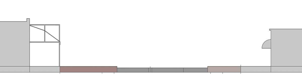
Varied Horizontal Rhythm
The diagram below illustrates the horizontal rhythm of of the historic Bank Block. The variability and human-scaled proportions of the Bank Block allow
for a sense of discovery and interest as one moves along Grandview Avenue. The intentionally desired variety of the Bank Block serves as a model for the establishment of district-wide design guidelines.
Vertical Use Mixture
The vertical mixture of uses allows for a combination of different activities to exist within the First and Grandview district while maintaining the walkability and variety that is essential to the vibrancy of this area. To foster vibrancy, first floor uses should be geared toward dynamic spaces that generate an active street life. The upper floors can be more passive in nature, suited for residential or offices uses. When a fourth floor is appropriate, office use is the preferred function in order to maintain the privacy of residents adjacent to any new development, while also providing

SCALE STRATEGY GUIDELINES


Vertical Scale Strategy Diagram
Horizontal Scale Strategy Diagram


section title: “Introduction”, “District Analysis”, “Vision”, “Implementation”
FIRST & GRANDVIEW DISTRICT PLAN
Timeless Charm, Modern Vision