The Y Bell Ranch is a acre stunning full operational cattle operation with e pansive Cascade Mountain views The custom main home is sq ft with a sq ft troph room bedroom bath beautiful grand entr with see through stone fireplace living room famil room with full bar theater room The ranch includes a guest house sq ft ranch manger house sq ft with original barn corrals chute main barn with stalls runs foaling stall indoor arena with bar shop with living quarters machine shop Ha equipment shed and much more
Galler Photo
Repo Sch
School in o a ea
K C ooked Ri e Elemen a School
ook Co n Middle School
ook Co n High School
C
C
Po ell B e Li i g I
Po ell B e i an ninco po a ed comm ni in C ook Co n O egon Uni ed S a e and named af e he nea b Po ell B e I i on O egon Ro e e of P ine ille and ea of Redmond Po ell B e po office a e abli hed in
Po ell B e Comm ni Cen e i loca ed among pic e e fa m land i h a b ea h aking ie of he Ca cade Mo n ain Range A ho mile di ance f om Bend O egon and mile f om Redmond O egon heading Ea
The Cen e i a pe fec en e fo edding bi hda e i emen pa ie holida pa ie b ine mee ing ed ca ion e en and heal h e en j o name a fe
Fo Ren al a ailabili plea e con ac o email o e en pb cen e com d ing b ine ho Monda h F ida a m il p m O Mi ion i o p o ide a afe f n and in i ing place fo o comm ni and g e o ga he fo a ide a ie of e en fo hei Famil and F iend
B a ada Ranch Re o i j min e f om he p ope and offe hole of golf an e e ian cen e e a an ho el cabin en al pa e en facili ie
e a m h o d e n c o m
Fea re P ope
Property Features List For Y Bell Ranch
• 435.80 Acres, 344.77 Acres of COID Irrigation
• Main Home Single Story 8863 Sq Ft 4 Bedroom 4.5 Bathroom
• Massive Rock See Through Gas Fireplace In Grand Entry
• All Rock Through Out Home Is Off Of The Property
• Gourmet Kitchen With Two Islands & Monogram Appliances
• Large Living Room With Massive See Through Fireplace
• Family Room With Full Bar & Pool Table Room
• Theater Room
• Master Bedroom With Rock Gas Fireplace & Two French Doors To Private Patio
• Large Laundry Room Near Bedrooms With Folding Table
• Covered Patio With Propane Heaters & Fans
• Outdoor TV Area With Pergola, Propane Heaters & Gas Rock Fireplace
• Fully Integrated Creston Lighting System & Alarm
• Attached 9196 Sq Ft Trophy Room
• Detached 2 Car Garage With Reznor Heater & Vac System, Temperature Controlled 5 Run Dog Kennel With Automatic Waterers and Reeled Hose For Cleaning
• Detached 4 Car Garage With Reznor Heaters & Exercise Room
• Salt Water Pool & Hot Tub
• Pond With Pier
• Shop 1 - 8700 Sq Ft With 8 Bays 14” Roll Up Doors & 2 Bays With 12”x 10” Doors, 5 Reznor Heaters & Car Lift, Walk-in Meat Cooler With Beer Taps & Meat Rail & Laundry Facility, Upstairs is 2 Bedroom Living Quarters
• Shop 2 - 7200 Sq Ft L Shaped With 8 Bays 14”x 14” Roll Up Doors & 1 Large Bay With 20’x 14” Roll Up Door With Reznor Heaters
• Barn - 6192 Sq Ft With All Steel Exterior Insulated Doors, Rubber Paver Flooring, 9 Stalls - Each With Nelson Waters & Steel Runs The Lead To Pasture, Foaling Stall Viewable Also From A Front Office Space With Bathroom & Kitchenette, Wash Rack, Feed Room, Tack Room & Hay Storage
• Indoor Arena - 59,500 Sq Ft With 27 12”x 14” & 2 10”x 8” Automatic Roll Up Doors For Summer Breeze, His & Hers Custom Bathrooms (women’s has ice maker outside of it) Bar & Viewing Area, Preifert Hot Walker, Preifert Chute, 2 - 1.5 Million BTU Heaters, Self-Draining Overhead Watering System, Custom Mechanical Cow For Cutting
• Wash Out By Arena
• On Site Bulk Fuel
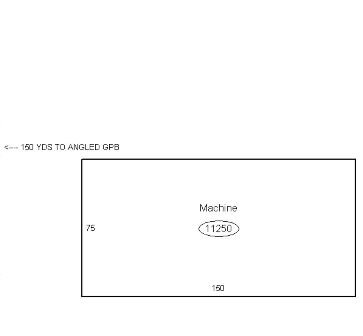
• Equipment/Hay Shed - 11,250 Sq Ft With Power & Lights
• 5 Pivots On Total Ranch ? Wheel Lines & Pods For Corners
• Fenced & Cross Fenced
• BLM Allotment AUMS 177
• All Tire Troughs Are Automatic & Heated
• Approximately 4 Miles Of Custom Steel Fencing
• 9 Heat Pumps
• Guest House Single Story 2967 Sq Ft 2 Bedroom 2.5 Bathroom
• Large Kitchen With Breakfast Nook & Eat At Bar
• Craft Room & Office Off Of Kitchen
• Living Room With Fireplace & French Doors To Back Deck
• Formal Dining Room
• Family Room With Round Oak Estates Of Beckwith Fireplace & French Doors To Back Deck
• Master Bedroom With Lots Of Windows & Sliding Glass Door To Back Deck & Walk-In Closet
• Octagon Hot Tub Room Off Back Deck (hot tub has been removed)
• Garden/Tool Shed
• Steer Barn With Hay Storage & Automatic Waterers & Heat Lamps
• 4 Stall Horse Barn With Automatic Waterers & Heat Lamps & Tack Room
• 3 Automatic/Heated Nelson Waterers In 3 Pastures
• Pond
• Ranch Mangers House Single Story 3020 Sq Ft 3 Bedroom 2.5 Bath
• Open Beam Living Room
• Large Open Kitchen & Dining Area
• Master Bedroom With Cascade Mountain Views, Deck Access
• Master Bath With Soaking Tub, Walk-In Shower, Walk-In Closet
• Two Guest Bedrooms With Jack & Jill Bathroom
• Large Laundry Room & Half Bathroom
• Attached 2 Car Garage With Reznor Heater
• Detached 3 Car Garage
• Original Barn With Huge Loft Area, Heifer Calving Set Up, Hydraulic Squeeze Chute and Sweep Inside, Steel Pens, Chute, Scale and Loading Doc
• Hay Shed
Informa ion Main H me
S e ch B i di g
STATE OF OREGON
(1) LAND OWNER
Owner Well I.D. First Name Address Zip
(4) PROPOSED USE Domestic Community Industrial/ Commericial Irrigation Livestock Dewatering State City
(9) LOCATION OF WELL (legal description) Tax Lot Lot Twp Range E/W WM Sec 1/4 1/4 Lat °'" or
(2) TYPE OF WORK New Well Deepening Alteration (repair/recondition) Abandonment Conversion (3) DRILL METHOD Rotary Air Rotary Mud Cable Auger Cable Mud Other Reverse Rotary
WATER SUPPLY WELL REPORT (as required by ORS 537.765 & OAR 690-205-0210) Thermal Injection Other
(5) BORE HOLE CONSTRUCTION Depth of Completed Well ft.
Backfill placed from ft. to ft. Material Filter pack from ft. to ft. Material BORE HOLE
Explosives used: Yes Type Amount
(6) CASING/LINER Dia Shoe Inside OutsideLocation of
(7) PERFORATIONS/SCREENS Method
TESTS:
Temperature °F Lab analysis Water quality concerns? Yes From Yes (describe below) ToDescription
(10) STATIC WATER LEVEL WATER BEARING ZONES From To Est Flow SWL(psi) SWL Date
Depth water was first found
(11) WELL LOG Ground Elevation
Hard Frac. Grey Basalt
Date Started
(unbonded) Water Well Constructor Certification
IcertifythattheworkIperformedontheconstruction,deepening,alteration,or abandonmentofthiswellisincompliancewithOregonwatersupplywell constructionstandards.Materialsusedandinformationreportedabovearetrueto the best of my knowledge and belief.
License Number Date
Signed (bonded) Water Well Constructor Certification
Iacceptresponsibilityfortheconstruction,deepening,alteration,orabandonment workperformedonthiswellduringtheconstructiondatesreportedabove.Allwork performedduringthistimeisincompliancewithOregonwatersupplywell construction standards. This report is true to the best of my knowledge and belief.
STATE OF OREGON
(1) LAND OWNER
Owner Well I.D. First Name Address Zip
(2) TYPE OF WORK New Well Deepening Alteration (repair/recondition) Abandonment Conversion (3) DRILL METHOD Rotary Air Rotary Mud Cable Auger Cable Mud Other Reverse Rotary
(4) PROPOSED USE Domestic Community Industrial/ Commericial Irrigation Livestock Dewatering State City
WATER SUPPLY WELL REPORT (as required by ORS 537.765 & OAR 690-205-0210) Thermal Injection Other
(5) BORE HOLE CONSTRUCTION Depth of Completed Well ft.
Backfill placed from ft. to ft. Material Filter pack from ft. to ft. Material BORE HOLE (Attach copy) DiaFromTo Special Standard
Explosives used: Yes Type Amount
(6) CASING/LINER Dia Shoe Inside OutsideLocation of
(7) PERFORATIONS/SCREENS Method
TESTS:
Temperature °F Lab analysis Water quality concerns? Yes From Yes (describe below) ToDescription
(9) LOCATION OF WELL (legal description) Tax Lot Lot Twp Range E/W WM Sec 1/4 1/4 Lat °'" or
Long °'" or
BUTTE HWY.
(10) STATIC WATER LEVEL WATER BEARING ZONES From To Est Flow SWL(psi) SWL Date
Well / Predeepening
Depth water was first found
(11) WELL LOG Ground Elevation
Date Started
(unbonded) Water Well Constructor Certification
IcertifythattheworkIperformedontheconstruction,deepening,alteration,or abandonmentofthiswellisincompliancewithOregonwatersupplywell constructionstandards.Materialsusedandinformationreportedabovearetrueto the best of my knowledge and belief.
License Number Date
Signed (bonded) Water Well Constructor Certification
Iacceptresponsibilityfortheconstruction,deepening,alteration,orabandonment workperformedonthiswellduringtheconstructiondatesreportedabove.Allwork performedduringthistimeisincompliancewithOregonwatersupplywell construction standards. This report is true to the best of my knowledge and belief.
Informa ion P nd
STATE OF OREGON
(1) LAND OWNER
Owner Well I.D. First Name Address Zip
(4) PROPOSED USE Domestic Community Industrial/ Commericial Irrigation Livestock Dewatering State City
(9) LOCATION OF WELL (legal description) Tax Lot Lot Twp Range E/W WM Sec 1/4 1/4 Lat °'" or
(2) TYPE OF WORK New Well Deepening Alteration (repair/recondition) Abandonment Conversion (3) DRILL METHOD Rotary Air Rotary Mud Cable Auger Cable Mud Other Reverse Rotary
WATER SUPPLY WELL REPORT (as required by ORS 537.765 & OAR 690-205-0210) Thermal Injection Other
(5) BORE HOLE CONSTRUCTION Depth of Completed Well ft.
Backfill placed from ft. to ft. Material Filter pack from ft. to ft. Material BORE HOLE (Attach copy) DiaFromTo Special Standard
Explosives used: Yes Type Amount
(6) CASING/LINER Dia Shoe Inside OutsideLocation of
FromToGaugeStlPlstcWldThrd Casing Liner
(7) PERFORATIONS/SCREENS Method
BUTTE
(10) STATIC WATER LEVEL WATER BEARING ZONES From To Est Flow SWL(psi) SWL Date
Predeepening
Depth water was first found
(11) WELL LOG Ground Elevation
TESTS:
Temperature °F Lab analysis Water quality concerns? Yes From Yes (describe below) ToDescription
Frac. Grey Basalt
Date Started
(unbonded) Water Well Constructor Certification
IcertifythattheworkIperformedontheconstruction,deepening,alteration,or abandonmentofthiswellisincompliancewithOregonwatersupplywell constructionstandards.Materialsusedandinformationreportedabovearetrueto the best of my knowledge and belief.
License Number Date
Signed (bonded) Water Well Constructor Certification
Iacceptresponsibilityfortheconstruction,deepening,alteration,orabandonment workperformedonthiswellduringtheconstructiondatesreportedabove.Allwork performedduringthistimeisincompliancewithOregonwatersupplywell construction standards. This report is true to the best of my knowledge and belief.
STATE OF OREGON
COUNTY OF CROOK
PERMIT TO APPROPRIATE PUBLIC WATERS
THIS PERMIT IS HEREBY ISSUED TO:
WAIBEL RANCHES LLC
8055 SW POWELL BUTTE HWY
POWELL BUTTE OR 97753
The specific limits and conditions of the use are listed below.
APPLICATION FILE NUMBER: G-17909
SOURCE OF WATER: A WELL (CROO 53667/L93135) IN CROOKED RIVER BASIN
RA TE: 0.004 CUBIC FOOT PER SECOND
MAXIMUM VOLUME OF STORED WATER: 2.2 ACRE FEET
DATE OF PRIORITY: AUGUST 22, 2014
USE: STORAGE FOR FISH, RECREATION, AND POND MAINTENANCE
PERIOD: YEAR-ROUND
Authorized Point of Appropriation:
Twp Rn2 Mer Sec Q-Q
15S 14E WM 33 SENW
Measured Distances
2386 FEET SOUTH AND 257 FEET WEST FROM Nl/4 CORNER, SECTION 33
Authorized Place of Use:
Twp Roe: Mer Sec 0-0
15S 14E WM 33 SENW
15 S 14 E WM 33 NESW
Measurement, Recording and Reporting Conditions:
A. Before water use may begin under this permit, the permittee shall install a totalizing flow meter at each point of appropriation, and maintain the device(s) in good working order. The permittee shall keep a complete record of the amount of water used each month, and shall submit a report which includes the recorded water-use measurements to the Department annually or more frequently as may be required by the Director. Further, the Director may require the permittee to report general water-use information, including the place and nature of use of water under the permit.
B. The permittee shall allow the watermaster access to the meter; where the meter is located within a private structure, the watermaster shall request access upon reasonable notice.
Ground Water Mitigation Conditions:
1. Mitigation Obligation: 2. 7 AF of mitigation water in the General Zone of Impact.
2. Mitigation Source: 2.7 AF mitigation credits from a chartered mitigation bank, or suitable replacement mitigation that meets the requirements of OAR 690-505-0610, within the General Zone of Impact.
3. Mitigation water must be legally protected instream in the General Zone of Impact for the life of the permit and subsequent certificate(s). Regulation of the use and/or cancellation of the permit, or subsequent certificate(s) will occur if the required mitigation is not maintained.
4. The permittee shall provide additional mitigation if the Department determines that average annual consumptive use of the subject appropriation has increased beyond the originally mitigated amount.
5. If mitigation is from a secondary right for stored water from a storage project not owned or operated by the permittee, the use of water under this right is subject to the maintenance and terms and conditions of a valid contract or satisfactory replacement, with the owner/operator of the storage project, a copy of which must be on file in the records of the Water Resources Department.
6. Failure to comply with these mitigation conditions shall result in the Department regulating the ground water permit, or subsequent certificate(s), proposing to deny any permit extension application for the ground water permit, and proposing to cancel the ground water permit, or subsequent certificate( s).
Scenic Waterway Condition:
Use of water under authority of this permit may be regulated if analysis of data available after the permit is issued discloses that the appropriation will measurably reduce the surface water flows necessary to maintain the free-flowing character of a scenic waterway in quantities necessary for recreation, fish and wildlife in effect as of the priority date of the right, or as those quantities may be reduced subsequently. However, the use of ground water allowed under the terms of this permit will not be subject to regulation for Scenic Waterway flows, provided the required mitigation is maintained.
STANDARD CONDITIONS
1. Failure to comply with any of the provisions of this permit may result in action including, but not limited to, restrictions on the use, civil penalties, or cancellation of the permit.
2. If the number, location, source, or construction of any well deviates from that proposed in the permit application or required by permit conditions, this permit may be subject to cancellation, unless the Department authorizes the change in writing.
3. If substantial interference with a senior water right occurs due to withdrawal of water from any well listed on this permit, then use of water from the well(s) shall be discontinued or reduced and/or the schedule of withdrawal shall be regulated until or unless the Department approves or implements an alternative administrative action to mitigate the interference. The Department encourages junior and senior appropriators to jointly develop plans to mitigate interferences.
4. The wells shall be constructed in accordance with the General Standards for the Construction and Maintenance of Water Wells in Oregon. The works shall be equipped with a usable access port, and may also include an air line and pressure gauge adequate to determine water level elevation in the well at all times.
5. Where two or more water users agree among themselves as to the manner of rotation in the use of water and such agreement is placed in writing and filed by such water users with the watermaster, and such rotation system does not infringe upon such prior rights of any water user not a party to such rotation plan, the watermaster shall distribute the water according to such agreement. G-17909.bp Page 2 of3
6. Prior to receiving a certificate of water right, the permit holder shall submit the results of a pump test meeting the department's standards, to the Water Resources Department. The Director may require water level or pump test results every ten years thereafter.
7. This permit is for the beneficial use of water without waste. The water user is advised that new regulations may require the use of best-practice technologies or conservation practices to achieve this end.
8. By law, the land use associated with this water use must be in compliance with statewide land-use goals and any local acknowledged comprehensive land-use plan.
9. Completion of construction and complete application of the water to the use shall be made within five years of permit issuance. If the water is not completely applied before this date, and the permittee wishes to continue development under the permit, the permittee must submit an application for extension of time, which may be approved based upon the merit of the application.
10. Within one year after complete application of water to the proposed use, the permittee shall submit a claim of beneficial use, which includes a map and report, prepared by a Certified Water Rights Examiner.
E. Timothy Wallin, Water Rights Program Manager for Thomas M. Byler, Director
Informa ion Irriga ion
Patron Taxlot Inquiry
Informa ion Allotment
Informa ion Se
Tax Statement Property
CROOK COUNTY PROPERTY INFORMATION
TAX INFORMATION FOR ACCOUNT #18839
The Crook County Tax Office receives the assessment and tax roll from the County Assessor in October each year and is responsible for mailing the tax statements and the subsequent processing of payments. If you have questions regarding proper ty tax payments or receiving the tax statement, please contact the Tax Office at or email
Account Information
Mailing Name: WAIBEL CHARLES B & JULIE G
Map and Taxlot: 15143300-00101-18839
Account: 18839
Situs Address: 8055 SW POWELL BUTTE HWY, POWELL BUTTE OR 97753 Tax Status: Taxable
Warning
This account may have potential additional tax liabilities, taxes due, or other special development conditions.
Current Year Tax Details
Tax Code Area: 0021
Original Tax Amounts
The on-line tax statement infor mation reflects the cer tified proper ty tax as of the October cer tification date and does not reflect any tax payments, value corrections, or delinquent interest on an account after the cer tification date
Payment History
Informa ion G est Home
S e ch B i di g
Maps
Ta Statement Property
CROOK COUNTY PROPERTY INFORMATION
TAX INFORMATION FOR ACCOUNT #1012
The Crook County Tax Office receives the assessment and tax roll from the County Assessor in October each year and is responsible for mailing the tax statements and the subsequent processing of payments. If you have questions regarding proper ty tax payments or receiving the tax statement, please contact the Tax Office at or email
Account Information
Mailing Name: WAIBEL CHARLES B
Map and Taxlot: 15143300-00100-1012
Account: 1012
Situs Address: 8051 SW POWELL BUTTE HWY, POWELL BUTTE OR 97753 Tax Status: Taxable
Warning
This account may have potential additional tax liabilities, taxes due, or other special development conditions.
Current Year Tax Details
Tax Code Area: 0021
Original Tax Amounts
The on-line tax statement infor mation reflects the cer tified proper ty tax as of the October cer tification date and does not reflect any tax payments, value corrections, or delinquent interest on an account after the cer tification date
Payment History
STATE OF OREGON
(1) LAND OWNER
Owner Well I.D. First Name Address Zip
(4) PROPOSED USE Domestic Community Industrial/ Commericial Irrigation Livestock Dewatering State City
(9) LOCATION OF WELL (legal description) Tax Lot Lot Twp Range E/W WM Sec 1/4 1/4 Lat °'" or
(2) TYPE OF WORK New Well Deepening Alteration (repair/recondition) Abandonment Conversion (3) DRILL METHOD Rotary Air Rotary Mud Cable Auger Cable Mud Other Reverse Rotary
WATER SUPPLY WELL REPORT (as required by ORS 537.765 & OAR 690-205-0210) Thermal Injection Other
(5) BORE HOLE CONSTRUCTION Depth of Completed Well ft.
Backfill placed from ft. to ft. Material Filter pack from ft. to ft. Material BORE HOLE (Attach copy) DiaFromTo Special Standard
Explosives used: Yes Type Amount
(6) CASING/LINER Dia Shoe Inside OutsideLocation of
FromToGaugeStlPlstcWldThrd Casing Liner
(10) STATIC WATER LEVEL WATER BEARING ZONES From To Est Flow SWL(psi) SWL Date
Well / Predeepening
Depth water was first found
(11) WELL LOG Ground Elevation
(7) PERFORATIONS/SCREENS Method
TESTS:
Temperature °F Lab analysis Water quality concerns? Yes From Yes (describe below) ToDescription
Date Started
(unbonded) Water Well Constructor Certification
IcertifythattheworkIperformedontheconstruction,deepening,alteration,or abandonmentofthiswellisincompliancewithOregonwatersupplywell constructionstandards.Materialsusedandinformationreportedabovearetrueto the best of my knowledge and belief.
License Number Date
Signed (bonded) Water Well Constructor Certification
Iacceptresponsibilityfortheconstruction,deepening,alteration,orabandonment workperformedonthiswellduringtheconstructiondatesreportedabove.Allwork performedduringthistimeisincompliancewithOregonwatersupplywell construction standards. This report is true to the best of my knowledge and belief.
Informa ion Se
Ra c Ma age H e
Informa ion
S e ch B i di g
Maps
Ta Statement Property
CROOK COUNTY PROPERTY INFORMATION
TAX INFORMATION FOR ACCOUNT #1015
The Crook County Tax Office receives the assessment and tax roll from the County Assessor in October each year and is responsible for mailing the tax statements and the subsequent processing of payments. If you have questions regarding proper ty tax payments or receiving the tax statement, please contact the Tax Office at or email
Account Information
Mailing Name: WAIBEL CHARLES & JULIE
Map and Taxlot: 15143300-00400-1015 Account: 1015
Situs Address: 16245 SW CRONIN RD, POWELL BUTTE OR 97753
Tax Status: Taxable
Warning
This account may have potential additional tax liabilities, taxes due, or other special development conditions.
Current Year Tax Details
Tax Code Area: 0021
Original Tax Amounts
The on-line tax statement infor mation reflects the cer tified proper ty tax as of the October cer tification date and does not reflect any tax payments, value corrections, or delinquent interest on an account after the cer tification date
Payment History
Informa ion Se
B ab 80 Ac
Informa ion
Maps
Ta Statement Property
CROOK COUNTY PROPERTY INFORMATION
TAX INFORMATION FOR ACCOUNT #1017
The Crook County Tax Office receives the assessment and tax roll from the County Assessor in October each year and is responsible for mailing the tax statements and the subsequent processing of payments. If you have questions regarding proper ty tax payments or receiving the tax statement, please contact the Tax Office at or email
Account Information
Mailing Name: WAIBEL CHARLES B & JULIE G
Map and Taxlot: 15143300-00500-1017
Account: 1017
Situs Address: UNDETERMINED SITUS ADDRESS
Tax Status: Taxable
Warning
This account may have potential additional tax liabilities, taxes due, or other special development conditions.
Current Year Tax Details
Tax Code Area: 0021
Original Tax Amounts
The on-line tax statement infor mation reflects the cer tified proper ty tax as of the October cer tification date and does not reflect any tax payments, value corrections, or delinquent interest on an account after the cer tification date