COASTAL ECHOES Domingo Marte
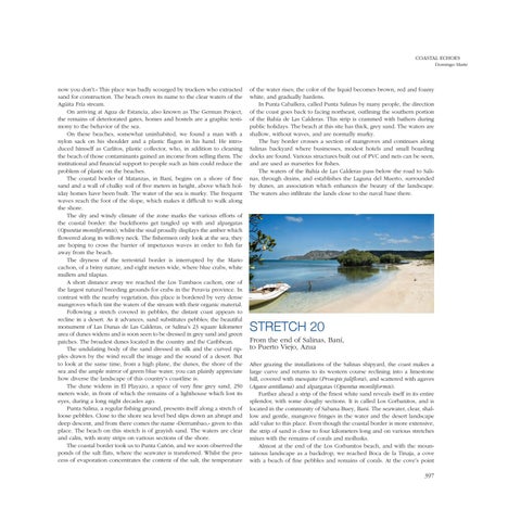
now you don’t.» This place was badly scourged by truckers who extracted sand for construction. The beach owes its name to the clear waters of the Agüita Fría stream. On arriving at Agua de Estancia, also known as The German Project, the remains of deteriorated gates, homes and hostels are a graphic testimony to the behavior of the sea. On these beaches, somewhat uninhabited, we found a man with a nylon sack on his shoulder and a plastic flagon in his hand. He introduced himself as Carlitos, plastic collector, who, in addition to cleaning the beach of those contaminants gained an income from selling them. The institutional and financial support to people such as him could reduce the problem of plastic on the beaches. The coastal border of Matanzas, in Baní, begins on a shore of fine sand and a wall of chalky soil of five meters in height, above which holiday homes have been built. The water of the sea is murky. The frequent waves reach the foot of the slope, which makes it difficult to walk along the shore. The dry and windy climate of the zone marks the various efforts of the coastal border: the buckthorns get tangled up with and alpargatas (Opuntia moniliformis), whilst the sisal proudly displays the amber which flowered along its willowy neck. The fishermen only look at the sea; they are hoping to cross the barrier of impetuous waves in order to fish far away from the beach. The dryness of the terrestrial border is interrupted by the Mario cachon, of a briny nature, and eight meters wide, where blue crabs, white mullets and tilapias. A short distance away we reached the Los Tumbaos cachon, one of the largest natural breeding grounds for crabs in the Peravia province. In contrast with the nearby vegetation, this place is bordered by very dense mangroves which tint the waters of the stream with their organic material. Following a stretch covered in pebbles, the distant coast appears to recline in a desert. As it advances, sand substitutes pebbles; the beautiful monument of Las Dunas de Las Calderas, or Salina’s 23 square kilometer area of dunes widens and is soon seen to be dressed in grey sand and green patches. The broadest dunes located in the country and the Caribbean. The undulating body of the sand dressed in silk and the curved ripples drawn by the wind recall the image and the sound of a desert. But to look at the same time, from a high plane, the dunes, the shore of the sea and the ample mirror of green blue water, you can plainly appreciate how diverse the landscape of this country’s coastline is. The dune widens in El Playazo, a space of very fine grey sand, 250 meters wide, in front of which the remains of a lighthouse which lost its eyes, during a long night decades ago. Punta Salina, a regular fishing ground, presents itself along a stretch of loose pebbles. Close to the shore sea level bed slips down an abrupt and deep descent, and from there comes the name «Derrumbao,» given to this place. The beach on this stretch is of grayish sand. The waters are clear and calm, with stony strips on various sections of the shore. The coastal border took us to Punta Cañón, and we soon observed the ponds of the salt flats, where the seawater is transferred. Whilst the process of evaporation concentrates the content of the salt, the temperature
of the water rises; the color of the liquid becomes brown, red and foamy white, and gradually hardens. In Punta Caballera, called Punta Salinas by many people, the direction of the coast goes back to facing northeast, outlining the southern portion of the Bahía de Las Calderas. This strip is crammed with bathers during public holidays. The beach at this site has thick, grey sand. The waters are shallow, without waves, and are normally murky. The bay border crosses a section of mangroves and continues along Salinas backyard where businesses, modest hotels and small boarding docks are found. Various structures built out of PVC and nets can be seen, and are used as nurseries for fishes. The waters of the Bahía de Las Calderas pass below the road to Salinas, through drains, and establishes the Laguna del Muerto, surrounded by dunes, an association which enhances the beauty of the landscape. The waters also infiltrate the lands close to the naval base there.
STRETCH 20 From the end of Salinas, Baní, to Puerto Viejo, Azua After grazing the installations of the Salinas shipyard, the coast makes a large curve and returns to its western course reclining into a limestone hill, covered with mesquite (Prosopis juliflora), and scattered with agaves (Agave antillana) and alpargatas (Opuntia moniliformis). Further ahead a strip of the finest white sand reveals itself in its entire splendor, with some doughy sections. It is called Los Corbanitos, and is located in the community of Sabana Buey, Baní. The seawater, clear, shallow and gentle, mangrove fringes in the water and the desert landscape add value to this place. Even though the coastal border is more extensive, the strip of sand is close to four kilometers long and on various stretches mixes with the remains of corals and mollusks. Almost at the end of the Los Corbanitos beach, and with the mountainous landscape as a backdrop, we reached Boca de la Tinaja, a cove with a beach of fine pebbles and remains of corals. At the cove’s point
397