COASTAL ECHOES Domingo Marte
In this area I had a guide who was an ex-sergeant of the Dominican army, and who had served as a body guard to one of the brothers of the dictator Rafael Trujillo Molina. He remarked that he was a peaceful man, and by the tone of his voice he appeared that way, but also said that he was always armed and that «what he looked for he found.» On hearing his stories about the seven times that «they looked and they found,» and on showing me the more than one-foot-long knife that he hid below his shirt, I only spoke to him after that about beaches. The Playa Nueva Romana property complex adjoins the Bahía Príncipe Romana hotel. Both benefit from a white sandy beach in the form of a fan, some two kilometers long and with a average width of eight meters, clear and such calm waters that the space seems like a swimming pool. One section of the beach is known as La Sardina and the other as Playa Montero, wider and with darker sand than the former. On this latter one and close to Caño Patricio, the adjoining hotel has built a breakwater out of rocks, that which has created a pond of calm waters within the sea. A short distance away we observed the impact of the Soco river mouth, which upon meeting the sea, creates a small beach of grey sand. The Soco river’s wide body, navigable and festooned with mangroves, is a well-known breeding ground for crabs.
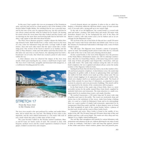
STRETCH 17 From the Soco river to the Ozama river The Soco river mouth is the spot preferred by sardine and mullet fishermen, and at which they use cast nets. The fishing of river crabs is also important, and the most utilized instrument is a star made with rods of iron, inside which they place as little strips of fish as bait. The coast becomes walled in; the beaches named Candelaria, Blanca and El Carey are barely cracks of sand. The seawater is clear, with frequent, medium waves and the coastal vegetation is limited to breach grapes, isolated coconut trees and creepers.
A novel element attracts our attention. It refers to the so called «bufeadero,» a blowhole within the cliff from which a spray of water ascends each 15 seconds with a strong puff up to two meters high. To the side of an old lighthouse, the coastal border is covered with sand and stones, creating a 600 meter deep and nearly 350 meter wide horseshoe shaped cove. In the background the arch of the Playa del Muerto is drawn, with calm waters used a lot by bathers and as an anchorage for the fishermen’s boats. The sea front of the city of San Pedro de Macorís has a small 150 meter long and 5 meter wide beach with thick and whitish sand. Next to it are the remains of a breakwater built inside it with large rocks, some of which remain in place. The cliff stops. The Higuamo river, formerly a mirror of prosperity, opens its wide, foul smelling mouth and its waters dirty the sea. Towards the north of the river is the dock and a floating electrical plant. On the coastal border, to the west of the Higuamo river, the presence of the Punta Blanca urbanization stands out, with its unkempt constructions. After this we found Playa Marota, a 600 meter long and two meter wide strip of thick and golden sand shaped like a horseshoe, with typically dark waters. The sandy strip continues along the sides of various hotel complexes; the sea is agitated and almost always carries the murky residues of the Higuamo within its body. Starting from Punta Macorís there has been a rise in the number of hotels and luxury property complexes. A short distance away, the sandy strip relinquishes its golden outfit; it dresses in glimmering white and triples the width of its body which is now made up of fine, dense sand. The sea doesn’t remain lagging it in its appearance and washes its murky body, which now displays itself in an opulent green-blue outfit. The beach of Juan Dolio extends for more than 2.5 kilometers, accompanied in many sections by attractive and even provocative buildings. This stretch will be very impacted by the density of the constructions still in progress. In the final stretch of the sandy strip of Juan Dolio, there is a more accessible section for the public named Playa Oasis beach, supplied by modestly built stores and restaurants. The main attraction is a small cove, appreciated for its medium deep waters, and ample shoreline. We reached Guayacanes, a 350 meter long and 50 meter wide strip of golden sand open to the public. The waters are moderately deep and brown due to the turbulence of the waves. Aside from being a bathing side, it is used as a berth for fishermen’s boats and in its surroundings there are a great number of simply built restaurants, appreciated for its yaniqueques (fried flour patty) and fish. A short distance away we found the final stronghold of sand of the coastal border, before a plateau of beveled reefs would seal the coast to Playa Caribe beach. Coquettish and active, Playa Caribe is found in the middle of two peaks in the cliff. The 90 meter long and 150 meter deep strip of fine and golden sand has a soft curved shape. The waters are clear, deep and very agitated. It is a highly visited bathing spot. The reef like slate strengthens and extends by various kilometers with protrusions and entrances in the sea, without allowing for any strip of sand to deny its continuity. Until final a wide and long strip appears, dressed in fine white sand above which vendors, plastic seats and parasols pose.
393