Project Storybook
Final Executive Summary
December 23, 2022


 Riddhi Batra Transportation
Kelly Cary Housing + Community
Alex Charnov Housing + Community
Mia Cherayil Technology + Data
Lynn Chong Housing + Community
Madeline Csere Transportation
Henry Feinstein Technology + Data
Robby Hoffman Development
Nata Kovalova Transportation Anastasia Osorio Environment
Yuchen Wang Urban Design
Marquise Williams Land Use + Transit
Shawn Li Development
Nell Pearson Environment
Riddhi Batra Transportation
Kelly Cary Housing + Community
Alex Charnov Housing + Community
Mia Cherayil Technology + Data
Lynn Chong Housing + Community
Madeline Csere Transportation
Henry Feinstein Technology + Data
Robby Hoffman Development
Nata Kovalova Transportation Anastasia Osorio Environment
Yuchen Wang Urban Design
Marquise Williams Land Use + Transit
Shawn Li Development
Nell Pearson Environment
Page 2
Nando Micale Instructor Danielle Lake Instructor
Statement of Purpose
In Fall 2022, a Studio group of a dozen students in the UPenn Masters of City & Regional Planning program focused their study on the eight-mile stretch of Anacostia River in Washington, DC from US Joint Base Andrews property at the Southeast to the District’s boundary with Maryland to the north. For the purposes of this project, the area is referred to as the Anacostia River Corridor or the River Corridor.
Running directly though the River Corridor is a 6-mile stretch of DC-295, which is D.C.’s only state highway. The highway serves as an important regional and local connector, but is also a significant barrier for nearby residents.

The premise of this studio is to look critically at the future of transit and development in the Anacostia River Corridor, with a focus on creating an equitable and resilient alternative to the highway. The materials produced for this Studio provide the D.C. Office of Planning (DCOP) and the D.C. Office of Energy and Environment (DOEE) with the preliminary materials needed to start an advocacy planning process in the Anacostia River Corridor.
The UPenn students worked closely with instructors — Nando Micale, Principal with the Philadelphia studio of LRK, and Danielle Lake, LRK architect and urban planner/designer and UPenn alumni — on developing this plan. The Studio also benefited from input from select members of the District’s Office of Planning (DCOP), Office of Energy and Environment (DOEE), and the larger Anacostia Waterfront Corridor Working Group (Working Group).
Page 3
How to use this interactive document
The Anacostia River Corridor team prepared this document as a summary of the plan’s final proposed recommendations. Designed for digital viewing and sharing, and to spark discussion and interest, in some places this summary may appear light on detail. Behind these recommendations, however, is a wealth of research and resources that the team organized within a series of 10 technical memos which we have called “deep dives.”
Within this document, interactive hyperlinked markers appear on the first pages of each topic with a relevant deep dive memo. To access the deep dives, you may click on any of the document covers shown on this page, or click on the markers throughout this document for more information on each topic area.
The following memos to provide additional information on topics that deserve a deeper dive. These are referenced throughout the document using this interactive, hyperlinked marker.
Click here to explore Deep Dive on this topic * Page 4
Contents
Regional + Planning Context
History of the River Corridor
Framing the Problem
Highways Past & Future
Why now?
Connectivity
Ecology
Development
Why a Boulevard?
Walk Down the Boulevard
Benefits for Connectivity, Ecology, Development
Example Site Area Plan
Concerns about Traffic
What is Bus Rapid Transit?
Addressing Gentrification
Project Timeline + Impacts of Construction
Community Process
Planning Workshop Kit
Page 5
River Corridor Context 1
Study Area
The geographic focus of this project is a portion of Washington D.C. that spans from U.S. Joint Base Anacostia-Bolling in the south to the D.C.Maryland border in the north. For the purposes of this project, the area is referred to as the Anacostia River Corridor or the River Corridor.
The Anacostia River Corridor contains multitudes. It includes the neighborhoods of Barry Farms, Anacostia, Fairlawn, Dupont Park, Greenway, Mayfair, Eastland Gardens, and Kenilworth. It also constitutes most but not all of Wards 7 and 8. The area interfaces with metro transit, freight rail, and numerous bus routes, and contains low-, medium-, and high-density residential areas as well as industrial and brownfield sites.
Running directly though the River Corridor is a 6-mile stretch of DC-295, which is D.C.’s only state highway. The highway serves as an important regional and local connector, but is also a significant barrier for nearby residents.
Though its history of disinvestment remains clear, the river corridor still sports a wealth of assets and a strong community.

Page 8 River Corridor Context
As of 2020, there are 136,653 residents living in the River Corridor, which accounts for about one fifth of the entire District of Columbia population (701,974). Despite being a large portion of the overall population, demographics across the Anacostia River look notably different across income and race.

The median income of households in Anacostia ($37,803) is significantly lower than DC ($82,604), as is the number of people living in poverty, with 28 percent in the study area versus the District’s 15 percent.
The study area is predominantly Black and AfricanAmerican, accounting for about 90 percent of the total population, compared to the District’s even share of White and Black residents (roughly 45% each).
28% below the poverty line vs.
15%
17% bachelor’s or advanced degree
About 27 percent of the River Corridor’s population falls under the age of 18 and only 12 percent are above the retirement age of 65. Almost half of the population (49 percent) falls between the ages of 18 and 54. The District sees less children under the age of 18 (18 percent) and about the same residents over the age of retirement (12 percent). Both populations’ single largest age category from ACS data is between 25 and 34 years old, with 17 percent for the study area and 23 percent for the District.
Educational attainment numbers show that about 40 percent of the study area’s population over the age of 25 has graduated from high school as their highest form of education, with only about 10 percent of the population with a Bachelor’s degree and 9 percent
with a master’s, professional, or doctorate degree. Data for the District shows that 17 percent of the population graduated from high school as their highest attainment, with 25 percent graduating with a Bachelor’s and 35 percent with a Master’s degree or higher.
As the significant differences in racial makeup, income, and educational attainment demonstrate, the Anacostia River Corridor stands out from the rest of the city. The history of segregation and disinvestment covered in the introduction reveals itself in this demographic overview, further highlighting the importance of addressing the harm I-295 has caused this long-standing D.C. community.
Demographics
D.C.’s
D.C.’s
vs.
63%
D.C. River Corridor 91% 45% Share of Black Residents $37,800 $82,600 Median Household Income D.C. River Corridor Page 9 River Corridor Context
Median Household Income by Census Tract. Source: United States Census Bureau (2020 ACS 5-Year)
History of the Anacostia River Corridor


Industrial Waterfront
Anaquash
The indigenous Nacotchtank inhabited what is now D.C. for an estimated 10,000 years before the arrival of English colonizers. In the early 1600s, about 300 tribe members lived in villages mostly along the eastern banks of the Anacostia River. The river was referred to as ‘Anaquash,’ or ‘village trading center’.

Agrarian Transformations

John Smith’s arrival in 1608 heralded the rapid settlement of the land east of the Anacostia by English landowners.

The Anacostia River offered the potential for deep-water ports and was poised for significant harbor development Dredging, dumping, and walling the Anacostia ensued.

1600 8400 BCE 1800 1900
Marshy low-lands
Army Corps Of Engineers, Map of Anacostia River, 1891
“Area to be filled shaded in red.”
Navy Yard Bridge, 1865
Page 10 River
Context
Anacostia flats July 20, 1912
Corridor
Parks & Parkways ”
The “reclamation” of the silted river, and the destruction of wetland habitats, to create a public park took several decades.
Highway Boom Corridor Restoration
Anacostia highway is conceived by the NCPPC in 1950. Ground is broken in 1958. Nearby neighborhoods including, Anacostia and Fairlawn, are separated from Anacostia Park. Neighborhoods including Kenilworth and Barry Farm are severed.


Meaningful efforts to restore the river and its surrounding communities begin. The Six Point River Restoration plan is adopted in 1991. The Anacostia River Clean Up and Protection Act is passed in 2009. But the highway remains omnipresent. Anacostia Freeway 11th Street Interchange under construction, 1964

Contaminated sites show history of the District’s treatment of eastern neighborhoods as disposable. The district openly burned trash in Kenilworth Park from 1942 -1968. In 1966-in one of the earliest environmental justice protests in US history-residents laid down in the street in an attempt to stop the trucks, but the city’s dumping and burning continued.


1950 1990 2020 2050
“
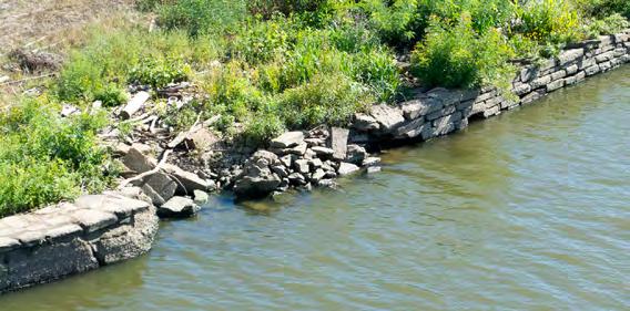
Example of the collapsing riprap walls along the Anacostia River
Breaking ground for Anacostia Park, 1923
New cultural landscape
Black Power activists visiting Barry Farms in 1967
Frederick Douglass housing project, 1942
Page 11 River Corridor Context
-- Krista Schlyer, River of Redemption
DC-295 Highway
DC 295 is the only state route within the District of Columbia. It measures 4.9 miles total and is mainly composed two segments:
• 2.3 miles of Kenilworth Avenue Freeway that runs from the Maryland state line to north of East Capitol Street, which sees an annual average daily traffic count of about 100,905 vehicles.
• 2.7 miles of Anacostia Freeway that connects I-295 south to Richmond up to East Capitol Street, which sees an annual average daily traffic count of about 127,762 vehicles.
295 serves as a regional connector north to the Baltimore-Washington Parkway via Kenilworth Avenue, south on I-295 towards Richmond, and provides access to downtown Washington DC for Ward 7, Ward 8, and Prince Georges’ County MD. It also provides local connections for employees and visitors to the Joint Base Anacostia-Bolling, DC Department of Employment Services building and DC’s Department of Housing and Community Development building.
Currently improving pedestrian safety and mobility throughout the I-295/ DC 295 corridor and across the Anacostia River has been the focus of DC’s Department of Transportation. Most notably the opening of the Fredrick Douglass Bridge allows for improved bike space into Anacostia Park and for a safer direct crossing experience into the Navy Yard & Buzzard Point.
MoveDC, the District’s Long-Range Multimodal Transportation Plan, identifies a number of communities with the greatest transportation needs, based on proximity to frequent transit, access to jobs and amenities, and safety risks. Many of these areas are also home to historically under-served communities of color, lowincome residents, and people with disabilities. The Anacostia River Corridor falls at the intersection of both these considerations, thus calling for a greater focus in transit equity to improve the corridor’s options for multimodal connectivity.

Page 12 River Corridor Context
Planning Context
The deliverables produced by the Anacostia River Corridor Studio are congruent with previous planning efforts conducted in Washington D.C.


Of the plans represented on this page, some are district wide, some are at the “waterfront” level, and some are for small areas like Poplar Point. This plan fits in between the district wide and small area scale, and is most aligned with the Resilient D.C. initiative established by Mayor Bowser.


The Anacostia River Corridor Studio strives to address the goals laid out in the Resilient D.C. plan, which aim to situate D.C. as a countrywide leader in equitable climate action.


In Fall 2021, another group of UPenn City Planning students sought to rethink systems that create resiliency as they envisioned a future for Poplar Point in Washington, DC for a studio course. In collaboration with DCOP, the project team envisioned the redevelopment of Poplar Point within the context of the Resilient DC initiative and other planning goals District-wide, as well as the site’s history, culture, and challenges.

Page 13 River Corridor Context
The Story of Highways 2
Why remove the highway?

Since the DC-295 highway was built, our values have changed. Today, we are striving to create a more environmentally just future. We recognize that transportation infrastructure like this does more to divide than it does to connect. The big fundamental underlying question here is who does this highway serve? Our research shows it’s not really the residents of southeast DC, and further, that for them it is a barrier blocking access to the parks, river, and greater DC.

Page 16 Story of Highways
River Culture
Southeast residents have important cultural ties to the Anacostia River, it is high time they had ease of access as well.

We’re so inspired by personal stories like this. This is Rodney Stotts, whose recently published memoir, Bird Brother, chronicles how when he got involved with the Anacostia River cleanup efforts at the Earth Conservation Corps, his encounters with wildlife and nature on the river completely transformed his life.[1] We think this opportunity to enjoy interacting with nature and communicating with wildlife is a fundamental human need that some communities have been cut off from. This project can serve as a vehicle to address that issue.

Rodney Stotts
“The Anacostia River still weaves its way into my dreams.”
On the Anacostia River, William Mitchener catches his first fish with cousin Byron Coleman. Photographer: Krista Schyler, author of River of Redemption
Page 17 Story of Highways
Rodney Stotts with Agnes, a Harris’s Hawk. Photographer: Greg Kahn
1951 City before highway

Highways Past: Environmental Racism and Displacement
Highways were constructed to serve convenience for a few, at the expense of environmental health and the well-being of the many.
America has a long and shameful history of constructing freeways through low-income neighborhoods; as highways were intended to serve white populations moving out to the suburbs while invariably displacing entire urban communities and creating areas of highspeed traffic and pollution that continue to affect the health and safety of those who live there.[2]
The economist Matt Yglesias put it this way: “Highways beget corruption of the city core: they make it less pleasant to live downtown, at the very same time they make it easier to live farther away.”[3]

Anacostia Freeway 11th Street Interchange under construction, 1964
Page 18 Story of Highways
Highways Present: Negative Public Health Impacts of
Highways
We also now understand highways to have many negative public health and ecological impacts.
The American Lung Association estimates that as many as 35-40% of all urban populations in North America live near a highway. Risks posed to those living within half of a mile of a highway include risks for serious chronic health conditions, impaired lung function, cardiovascular disease, childhood asthma. Risks posed to those living within 300 meters of a highway also include higher risks for decreased brain function, dementia, and chronic obstructive pulmonary disease in older adults.[4]

In addition to these public health impacts, highways cause stormwater runoff to increase and have a number of ecological downsides. DC’s equity-based approach to resilience planning must be deployed to improve environmental and public health while mitigating negative externalities such as green gentrification.

The area most affected by risks of impaired lung function, increased risk of death from cardiovascular disease, and the onset childhood asthma is roughly the band within 0.3 miles of the highway.
(American Lung Association, 2022)
Adults living closer to the road—within 300 meters—have higher risk of dementia as well as developing chronic obstructive pulmonary disease.
(Anderson et al., 2011)
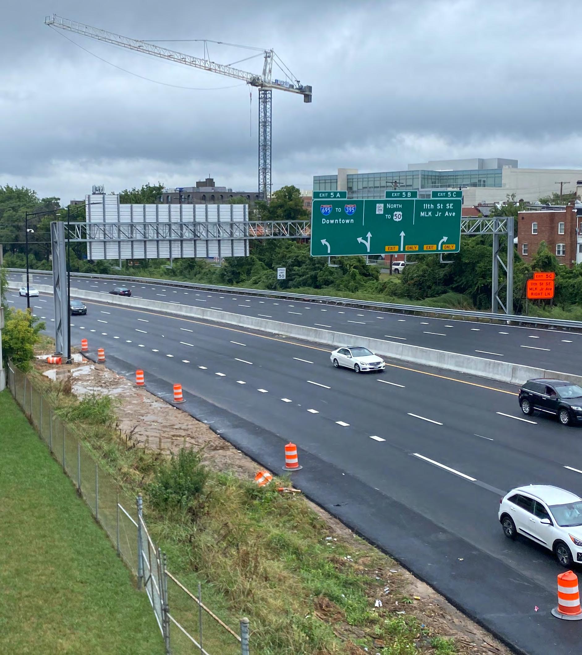
DC-295 During Rush Hour
Page 19 Story of Highways
Highways Future: A Global Movement to Reimagine Highways
The idea of highway removal or conversion is coming from a worldwide movement where many cities are asking, “What can we do with the space of this highway that no longer serves our needs and no longer serves the kind of future we want?” Renewed calls for social and environmental justice are bringing the highway issue to the forefront of national conversation, resulting in this movement to reclaim the space of highways for the city for people.
According to the Congress for New Urbanism, “18 American cities have either removed, covered, or committed to transform urban highway corridors.”[5] We’ve studied these precedents carefully and incorporated lessons from all these different places as much as possible into our plan.


Notably, in a lot of these places, the removal of the highway has been a catalyst for new investments and new developments. The following three case studies highlight these impacts in detail:

The Park East Freeway in Milwaukee, Wisconsin was a one-mile freeway spur leading from I-43 to downtown Milwaukee. They found it was actually less expensive to tear it down than it would have been to rebuild it. The city demolished the freeway in 2003, for a total cost of $25M, where it would have cost $100M to rebuild the freeway as is. And so that was part of the value proposition here, and it opened up immense tracts of land for new development, which has now seen over a billion dollars of development happen, with more coming down the pipeline. Since the removal of the freeway, the Park East Corridor has seen over $1.06 billions of private investment in development projects, with the potential for an additional investment of $250 million on the few remaining undeveloped parcels.[6]

ROCHESTER SYRACUSE NEW ORLEANS BOSTON
Page 20 Story of Highways
Boston’s Big Dig involved constructing a 1.5-mile tunnel and rerouting I-93 through central Boston. The tunnel and rerouting were completed in 2007 and cost $14.5B. Original plans for the Big Dig included many mass transit investments, including a transit tunnel to connect South Station and Logan airport, connections to existing subway lines, and restoration of historic streetcar service. As of 2022, however, only the new transit tunnel is built and operational. Despite the challenges and giant budget, this project did have some success, including the establishment of a heavily used linear park running along the former highway’s footprint.[7]
The Cheonggyecheon Highway in Seoul, Korea was removed from 20012005. In the 1990s, the Cheonggye area recorded the highest levels of noise and congestion in Seoul. However, in 2001 the plans for highway removal began as part of a plan to transform Seoul into a tourism hub. The final budget of the project was $323M and was expected to attract $9.2B of private investment. The project was centered on revitalizing the Cheonggyecheon Stream by removing the highway and creating a central plaza and multimodal roads. The project included increased bus routes around the area, as well as increased parking fees and stricter control over parking generally. It was also designed on a 200-year flooding interval assumption. The project is largely considered a success, attracting 64,000 daily visitors, an increased number of businesses, and reduction in the urban heat island effect.[8]


PROVIDENCE SEOUL
MADRID
MILWAUKEE
PARIS SAN FRANCISCO
Page 21 Story of Highways
= substantially completed or implemented project
Why now?
After reviewing the story of highways, we have seen their historic and present harms, as well as how highwaysto-boulevards projects can serve as powerful tools for revitalization. However, the other question to address is “why now?” - Why is now the right moment to explore a project like this? We outline five reasons in the following pages.

Page 22 Story of Highways
Health impacts are happening now.
Despite significant environmental restoration gains and advocacy efforts made in the past 40 years, today, Anacostia River Corridor residents are still disproportionately impacted by environmental hazards including air pollution, as well as the impacts of climate change, especially flood risk and extreme heat. Although air pollution levels in DC are considered within safety standards, around 20% of residents in Ward 8 (which is partially included in the Anacostia River Corridor), suffer from asthma compared to 12% in DC as a whole.[9] This difference can be tied closely to the presence of the highway.

Similarly, lack of accessible and sufficient medical care forces these residents to travel across the river to get to hospitals. However, missing public transportation links and low car ownership in some neighborhoods makes this difficult and leads to a cycle of worsening health outcomes. The removal of the highway will provide an opportunity to enhance connectivity and public transportation options to facilitate these connections.

Unsurprisingly, data shows that temperatures are relatively higher in census tracts along the highway compared to those further east. These tracts also contain less tree cover. The Heat Sensitivity Exposure Index, which provides information about which tracts are most vulnerable and exposed to extreme heat indicate that these census tracts are least likely to be able to cope and adapt to heat.[10] These conditions will play a role in how we think about environmental equity in the plan.
20% Rate of asthma among Ward 8 residents
DOEE Monitoring sites in Ward 7 record higher averages of particulate matter, carbon dioxide, and nitrogen oxide than other sites in the District.
0.6 - 0.7
Score on the Heat Vulnerability Index (with 1 being the most) vulnerable
1-
Page 23 Story of Highways
Environmental risks are increasing.
This plan focuses on creating sustainable and flood-resistant infrastructure, which will be critical as DC prepares for worsening flooding over the next 15 to 30 years. Due to global warming, sea levels are projected to rise over the coming decades to levels not seen for more than 10,000 years. Since the Anacostia is part of the greater Chesapeake water system, as the sea level rises, simple high tides will result in local flood conditions for sustained time periods.
Another effect of climate change will be worsening storms. Due to aging and overburdened infrastructure, flooding from stormwater in the interior of neighborhoods is already a significant concern in DC. The issue of stormwater overflow into the Anacostia River has for a long time contributed to the heavy pollution of the waterway, but stormwater also affects low-income neighborhoods east of the river in the form of basement backups, surface flooding, and impaired roadways.[11]
According to the Union of Concerned Scientists' 2014 Encroaching Tides Report, The mid-Atlantic coast is expected to see some of the greatest increases in flood frequency. Washington, DC can expect more than 150 tidal floods a year.


11.9” in sea level rise by 2045


400 Predicted number of flooding events per year by 2045 in DC

2-
Page 24 Story of Highways
Development pressures threaten housing security


A project at this scale presents a remarkable opportunity to address DC’s housing crisis. As will be covered later in this plan, a lot of land can be opened up for new development with the removal of DC-295. The implications of this could affect the supply of affordable housing within the corridor if managed appropriately.

Currently, homeownership rates in the Anacostia River Corridor are low, and the existing homes are older than elsewhere in DC. Also, as of 2020, more than half of the residents in the Anacostia River Corridor were rent burdened, meaning they spent more than 30% of their income on rent.[12] At the same time, the Anacostia River Corridor has seen more development pressure in recent years as millions of dollars have been invested in the neighborhoods directly across the Anacostia River on its western waterfront. [13] This all means - if development is done inequitably and rents go up more than they have in the past, then there is a very real risk of displacement for current residents.
This tone is one shared by many residents. For example, In an article about DC’s rising housing affordability, Kimberly, who is now a former resident of SE DC, stated that as a 3rd generation Washingtonian, it’s hard to see people struggle to live in the city. With this in mind, DC has already recognized the urgency of preserving housing affordability in the area.[14]
$318,400 +10%
Home values increase from 2010-2022
Our Housing Policy Toolkit deep dive examines The District’s Housing Equity Plan which aims to raise the share of dedicated affordable units from 16 percent in 2020 to 21 percent by 2050.[15] Equitable development on new land opened up by the highway’ removal has the potential to increase the supply of affordable housing and programs that support existing residents which can transform housing in the area at a crucial time.
53% Rent burdened households +7%
$1,024 Avg. gross rent increase from 2010-2022
3-
Page 25 Story of Highways
The future of mobility is multimodal.


The removal of DC-295 offers an opportunity to push both the Anacostia River Corridor and DC towards a multimodal future. While ARUP forecasts the total urban vehicle count to increase by 3% annually, the proportion of cities’ population growth is moving at a much more rapid pace, bringing a shift in design paradigm from designing cities for cars to fitting vehicles into cities.[16]

Many experts believe now is the time to reimagine roadways that could include power generation to charge electric vehicles on the go, adaptive speed limits and narrower lanes to better control traffic, and connect to technology.[17] Similarly, creating an integrated ecosystem of shared micro-mobility among existing transportation options and hubs will encourage modal shifts from driving to other forms. DC is a leader in the e-scooter and bike-share revolutions and is now discussing ways to create a more equitable and connected future of transportation such as making public Metrobus rides free and subsidizing MetroRail rides for DC residents.[18]
In our Future of Mobility deep dive we explore these possibilities and more practices that discourage owning a private vehicle and the reliance on traditional highways for transportation.


4 -
Integrated ecosystem of shared micro-mobility among existing transportation options.
Reduced vehicle miles traveled from adoption of automated vehicles and ride-sharing practices.
Reimagined roadways that include power generation, adaptive speed limits, and narrower lanes promoting safety and affordability.
DC is already incentivizing transportation mode shift.
Page 26 Story of Highways
There’s $$$ on the table.
From a transportation perspective, federal funding will support Highway to Boulevard efforts through the Reconnecting Communities pilot program. The program provides $1B over five years to reinvest in transportation infrastructure that better connects communities to economic opportunities.[19] For example, California recently announced $150M in state funding for a parallel program as well, with other states potentially following suit.[20] These funds can be distributed via planning grants to explore area-specific options that work for respective communities, making this the perfect time to begin exploring concrete alternatives to DC-295.


However, there are also a number of federal funding sources available from Federal Agencies like FEMA, EPA, and HUD to support building community resilience with nature-based solutions. These include the Coastal and marine habitat restoration grants, national coastal resilience fund, hazard mitigation assistance grants, and the community development block grant program.[21] Finally, if we layer into this project’s green-blue infrastructure that help deal with ecological issues we can add funding from other sources that support such projects.

5-
D.C. expects to receive more than $3.3 billion in federal infrastructure funds.
Reconnecting Communities Pilot Program = $1B for Urban Highway Removals
Page 27 Story of Highways
+ Grant programs for flood mitigation, environmental restoration, affordable housing through FEMA, EPA, and HUD
3
What can this movement achieve?
Three Frameworks Connectivity


Bringing down the highway offers opportunities to largely reshape the river corridor in several ways. The effort to imagine this generates important questions about how to balance sets of priorities.
In the course of our research, we identified three frameworks which capture the range of opportunities presented by a project of this size. They are Connectivity, Ecology, and Development. In this section, we will discuss how these frameworks served as a guide to ensure our proposal met the corridor’s most pressing challenges.
Good connectivity means the entire area is connected by an active, accessible, and diverse transportation system.


Ecology


Development
The development framework is all about how to create conditions for sustainable, inclusive growth, and an equitable quality of life.
The ecology framework describes how human and ecological processes can coexist, supporting the natural systems that maintain breathable air and drinkable water, mitigate heat, and provide habitat for wildlife.


Page 30 Goals & Frameworks
Connectivity
Existing Conditions
Connectivity arose as a framework for this advocacy plan due to the regional and local importance of DC-295. Regionally, the segments of the Anacostia Freeway & Kenilworth Avenue connect to Suitland Parkway and help residents of MD and VA commute to downtown DC from the west. It also allows drivers to pass through the district from I-295 south towards the Baltimore-Washington Parkway going north.

Locally, it provides access to the rest of the District for Wards 7 & 8 and also provides local connections for employment nodes at Joint Base Anacostia-Bolling military base, the DC Department of Employment Services building, and the DC Department of Housing and Community Development building.
Despite its regional and local significance, there are connectivity challenges that the highway presents. The highway encourages a heavy reliance on driving, however, transit and other modes of travel are important for residents of the Anacostia River Corridor. Only 40% of households have access to a vehicle.[22] As a result, 2 out of every 5 corridor residents rely on transit to get to work.[23]

40.3% of households without access to a vehicle
4-mile
The Pedestrian Friendliness Index accounts for the physical state of sidewalk infrastructure
Source: MoveDC
Metro and Circulator Station Walksheds showing a barrier to travel for corridor residents
Page 31 Goals & Frameworks
Transit gap stretching from end-to-end of the corridor
2.5-mile
barrier to pedestrian crossing across into Anacostia Park
Although many residents rely on this transit for traveling, there is a 4-mile transit gap in the corridor. With nearly 94% of residents leaving the area for work, many face challenges just to merely complete their daily commute. [24] The highway compounds these barriers created by a lack of transit access by physically blocking access to the park and limiting travel between neighborhoods. Particularly concerning is the 2.5 mile stretch in the central portion of the corridor, which lacks any pedestrian crossings over or under the highway.
Infrastructure enabling safe crossing of DC 295 on foot is limited to 5 pedestrian bridges and 7 underpasses with sidewalks.


 View from inside a pedestrian bridge crossing DC 295 near the Minnesota Ave metro station
Page 32 Goals & Frameworks
Good Hope Rd SE, looking towards Anacostia Park. This is the closest access point to the park on foot from downtown Anacostia.
To create safe and welcoming ways to access the riverfront park - for residents of all ages and abilities
Connectivity Goals

With these existing circumstances in mind, this advocacy plan emphasizes goals based upon improving connectivity in the corridor: To improve connections between neighborhoods East of the River, and ensure more equitable access to goods and services
To enhance access to and from jobs, opportunities, and attractions in the Greater DC area


 A portion of the DC 295 across from the Anacostia Metro Station in Southeat, DC (Ward 8).
Page 33 Goals & Frameworks
Ecology
Existing Conditions
The River Corridor has enormous potential. The area boasts over 1,800 acres of parkland along the Anacostia River. By comparison, New York’s Central Park offers only 843 acres.[25] Boston’s Emerald Necklace sweeps in six linear miles around the city, compared to the Anacostia River Park’s nine-and-a-half mile circuit around both sides of the river. This waterfront includes more than 700 acres of water and wetlands, including the stunning Kenilworth Aquatic Gardens.[26]


Flood modeling
Although it is a serious and escalating problem, there is no single authoritative mapping of flooding in the District. So we wanted to do our own exploratory analysis of the hydrology system in the area. We looked at where water tends to accumulate, the patterns for the direction of the flow of water, and combined this with soil drainage , slope and elevation to create a high-level flood risk model. Unsurprisingly, we see that areas closest to the river are most vulnerable to flooding but there are also pockets in the interior where risk is significant. For more information, refer to the Climate Resilience deep dive.
Identifying areas for new stormwater infrastructure using flow analysis


610
buildings currently in flood hazard zones
26%
20% of household in this study area stay in their homes longer than 30 years, 33% stay for over 20 years.
If a household is living within a 1%-annual-risk flood hazard zone, that means over a 30-year span there is a
likelihood that their home will flood while they are living in it.
Interior Flooding on Anacostia Avenue in July 2021 (NBC4 Washington).
MLK Ave and Good Hope Rd - Entrance to the Anacostia Park
Minnesota Avenue and Benning Rd Mayfair Area
Page 34 Goals & Frameworks
According to analysis of existing flood maps, today there are over 600 buildings within flood hazard risk areas inside our study area east of the Anacostia. Estimates also show that by 2080 the areas of flood risk could more than double in size.


Page 35 Goals & Frameworks
Resiliency hubs
Climate Ready DC and Resilient DC are supporting a pilot Resilience Hub in Ward 7, with the intention of supporting “communities to become more selfdetermining, socially connected, and successful.”[27] Modeled after programs in Baltimore and Los Angeles, the Resilience Hub will serve people during one-time disaster events as well as meet day-to-day needs.
The Resilience Hub Community Committee (RHCC) envisions there should be a center within walking distance of every Ward 7 resident. Some initial efforts have been running out of the Faunteroy Community Enrichment Center.

Advocacy efforts
The River Corridor has benefited from robust advocacy and stewardship conducted by community groups, regional coalitions, and federal agencies. Several organizations today are taking unique approaches to improving water quality while promoting environmental stewardship and community engagement. These include the Anacostia Riverkeeper, Earth Conservation Corps, Anacostia River Society, Urban Waters Federal Partnership, among many more.

2032
Page 36 Goals & Frameworks
On track to render the river fishable and swimmable by
Use new roadway infrastructure as a vehicle for capturing water.
Ecology Goals
This advocacy plan emphasizes goals based on the enhancing ecological health of the corridor:


Bake-in resilience strategies to any development that is triggered by the highwayto-boulevard intervention.
Connect more people to more nature through better park and recreation access.
Page 37 Goals & Frameworks
Development
Existing Conditions
In terms of development, the River Corridor has already seen a lot of construction activity in recent years. In the Historical Anacostia area alone, 2,600 new units of housing are in the pipeline, which outpaces the number of new units slated for many other parts of D.C.[28] Relatedly, median home values and average rents have continued to rise over the past decade. At the same time, the study area has a low homeownership rate and an aging housing stock. A fifth of the River Corridor has lived in their homes for 20 or more years and more than half of residents are considered cost burdened, spending more than 30% of their income on rent.[29]
Neighborhoods in the River Corridor are in a precarious position as development attracts while current residents continue to struggle with housing cost and quality. While this advocacy plan is not a housing equity plan, there are clear gentrification and displacement risks in the area, which could be exacerbated by removing the highway if not addressed preemptively.

2,600+ new units
of housing already in the development pipeline, in the Historic Anacostia area alone, a third of which are designated as affordable
1.8 million sq ft of potential developable land opened by this project
Allowing for the creation of approximately
1,633 new units of housing
Page 38 Goals & Frameworks
Proposed

Locations

 Example of typical single family detached housing.
renderings for a future develompent.
Credit: Redbrick LMD
Example of typical single family detached housing.
renderings for a future develompent.
Credit: Redbrick LMD
Page 39 Goals & Frameworks
of Affordable Housing in the Anacostia River Corridor
Increase housing stock while maintaining affordability and alleviating cost burden
Development Goals
The goals for the development framework are first and foremost to build a better Corridor for the people who already call the area home. Ensure new development is climate resilient and zoned for responsible land use


Ensure new development expands upon neighborhood character and amplifies existing assets


 Italian Row in Historic Anacostia
Page 40 Goals & Frameworks
A holistic solution for the Anacostia River Corridor


With all of these goals established, the question became: what does it actually look like to achieve all of these goals along the entire corridor? What moves have to be made to lessen the barrier that the highway poses, along the entire corridor? The character of the corridor differs widely, with development, connectivity and ecology intermingling in different ways. You can see some of this variation illustrated in these sections - one from the north and one in the south.
It is clear that to achieve all of the framework goals along the whole corridor, interventions will have to account for the changing neighborhood character along the five miles of highway, while still treating the corridor as an interconnected whole.
Anacostia High School
Anacostia Recreation Center DC-295 Chamberlain Elementary School District Yacht Club
Section through Anacostia Recreation Center
PEPCO
MetroRail
Section through PEPCO and National Arboretum
Site National Arboretum
Atrium Apartments Senior Housing DC-295
Page 41 Goals & Frameworks
Imagine a boulevard 4
Case Study Research Highway Removal Alternatives


Tunneling or Burying + Capping Conversion to Boulevard Removal + Conversion (Park or New Development) Before and After: The Big Dig, Boston Before and After: Bonaventure Expressway, Montreal Before and After: Cheonggyecheon, Seoul Page 44 Imagine a Boulevard
In considering the Anacostia River Corridor and the advantages and challenges of each approach, the boulevard approach appears to be best suited for the local context and for advancing connectivity, resilience, and equitable development in the communities that surround DC-295.
Highway removal precedents around the world reflect three main ways to remove a highway: reroute the highway into an underground tunnel, convert the highway into a boulevard, and replace the highway entirely with a new or restored street grid. The table on this page lays out benefits and challenges of each approach.
A boulevard would retain the corridor’s role as a highercapacity north-south connector yet still serve to reconnect neighborhoods to the riverfront park and one another. In addition, a boulevard can take on many different forms, which offers the flexibility for the removal of DC-295 to adapt to changing local conditions along the corridor. Lastly, a boulevard approach takes advantage of the existing momentum surrounding the Highways to Boulevard movement.
The boulevard approach is one amongst many possible methods to transform the DC-295, and has been chosen by our studio as a basis for imagining alternatives for the Anacostia River Corridor.
Tunneling or Capping Boulevard Removal + Conversion
Benefits
• Traffic going north and south through the corridor remains continuous
• Improve health equity through removing pollutants, mitigating heat, and reducing flood risk
• Restore open space that increases biodiversity gains and improves climate resilience
• Increase access to public amenities, recreation, and active transportation
Challenges
• Highest cost and longest time to implement
• Does not shift travel behavior away from polluting, private vehicles
• Likely requires high-end/luxury development to recoup project costs which does not fit in with goals of equitable development or the existing neighborhood fabric
Benefits Benefits
• Maintain a high level of travel capacity throughout the corridor
• Create smoother connections to the riverfront recreation spaces
• Shape development along the boulevard, contributing to placemaking and re-knitting efforts for the community
• Increase opportunities for resilience through the use of blue-green infrastructure assets lining boulevard and a depressed median
• Eliminate infrastructure barriers to open and recreational space for the community
• Expansive multimodal transit corridor investments would create new highcapacity connections north-south between existing neighborhood transit nodes, routes, and trails
• More green space and stormwater interventions to address flood risks, air quality, and urban heat effects
• Catalyze development that amplifies existing assets and preserves neighborhood character
Challenges Challenges
• Will require some former users of DC-295, especially those who use it for through travel, to shift away from driving motorized vehicles or take new routes
• Non-motorists could still face issues safely crossing at busier stretches of the boulevard
• Will require the largest change in travel behavior away from driving alongside the largest investments in transit
• Biggest change from what exists today
Page 45 Imagine a Boulevard
What is a Boulevard?
Boulevards can take many forms from pedestrian-oriented main streets to higher capacity downtown thoroughfares. Some boulevards like State Street in Madison, WI function as pedestrian-oriented main streets with bicycles, transit, and vehicles sharing lanes and traveling at low speeds. On the other hand, downtown boulevards like the Bonaventure Expressway in Montreal have a dedicated right-of-way for transit and wide medians that serve as parks and bike share station locations. However regardless of their context, boulevards have a few important things in common.
Common features of a boulevard include:
• Multimodal travel lanes
• Wide range of vehicle capacity
• Frequent crossings to maximize connections
• Traffic calming measures like crossing islands, curb extensions, and visible crosswalks

• Mixed commercial and residential development on one or both sides
Together, these features prioritize people over cars. This section considers typical boulevard elements in the context of the Anacostia River Corridor to imagine what a boulevard in place of DC-295 could look like. One common element across segments would be a new high-capacity transit option. A new bus rapid transit system, for instance, could run north and south between Anacostia and Deanwood Metro stations, filling in existing transit gaps and providing new ways to travel along the corridor without needing to get in a car. For more information on bus rapid transit (BRT) systems and why one could work well in the Anacostia River Corridor, check out the “Bus Rapid Transit” deep dive.
The local conditions differ throughout the Anacostia River Corridor, which suggests the boulevard will have a different configuration depending on the corridor segment.
 Bonaventure Expressway, Montreal, CA
State Street, Madison, WI
Bonaventure Expressway, Montreal, CA
State Street, Madison, WI
Page 46 Imagine a Boulevard
Imagine a Boulevard in Place of DC-295
Potential segments
Proposed boulevard segments

Proposed Bus Rapid Transit

Existing bike lane
Existing bike share station
Existing Metro station
1 Six-lane multimodal boulevard
2 Parkway
3 New bridge
4 Four-lane multimodal boulevard
Page 47 Imagine a Boulevard
Imagine a Boulevard
Six-lane multimodal boulevard: River Terrace to Kenilworth
The northern portion of DC-295 sees the most traffic today with residential neighborhoods and businesses sitting along both sides of the highway. As a result, this busy stretch of highway could lend itself well to a six-lane multimodal boulevard. The boulevard could continue to serve as a high-capacity connector to greater DC and other parts of the river corridor, however, unlike DC-295, this boulevard would accommodate all types of travelers, not just those in private vehicles.
By enabling more access points to and across the road, especially for pedestrians and cyclists, the boulevard could also create opportunities for new commercial activity and a larger development at the PEPCO site.


Proposed features:
• Dedicated bus rapid transit (BRT) in inner lane each way


• Two lanes of vehicle traffic each way
• Two-way cycle track on west side
• Retention median

• Sidewalks on both sides
• Development on both sides except where boulevard approaches CSX rail
 Proposed boulevard section (Streetmix)
Cycle track in Seattle, WA
Existing Conditions of DC-295 at highlighted section
Proposed boulevard section (Streetmix)
Cycle track in Seattle, WA
Existing Conditions of DC-295 at highlighted section
0 0.25 0.75 0.5 1.0 Mile Existing bike lane Proposed Bus Rapid Transit Proposed boulevard segment Existing bike share station Existing Metro station 1
Page 48 Imagine a Boulevard
Imagine a Boulevard
Parkway from D St SE to Capitol St SE
After E Capitol St SE, DC-295 curves into the park, at which point the new boulevard could look more like a parkway. Today, there are no connections between DC-295 and the park. In the future, the parkway could run at grade with several crossing points to ensure this segment, like the others, reverses DC-295’s role as a barrier between neighborhoods, the park, and the river.
This portion could narrow into two lanes of traffic in each direction, slowing vehicle speeds down as the boulevard leaves the mixed commercial and residential areas. A cycle track, wide sidewalks, trees, and park space would line both sides of the parkway, creating a new space for residents and visitors to enjoy the park.

Proposed boulevard segment

Proposed features:
• Dedicated bus rapid transit (BRT) in inner lane each way

• Two lanes of vehicle traffic each way
• Two-way cycle track on west side with a connection to the river trail
• Retention median
• Sidewalks on both sides
• Park on both sides, no development
Proposed Bus Rapid Transit
Existing bike lane

Existing bike share station
Existing Metro station
Green Street in Nashville, TN
Eastern Parkway in Brooklyn, NY
Existing Conditions of DC-295 at highlighted section
2
0 0.25 0.75 0.5 1.0 Mile
Page 49 Imagine a Boulevard
Imagine a Boulevard
Bridge Connecting Southeast Blvd to New Parkway
Today, there is a long stretch between Pennsylvania Avenue and E Capitol St without a connection over the Anacostia River. While there is a CSX railroad bridge around where Massachusetts Avenue meets 30th St SE, there are no opportunities for vehicles, pedestrians, or people on bicycles to cross. Additionally, the existing CSX railroad bridge is extremely low new and prevents any boat larger than a canoe from crossing. The conversion of DC-295 into a boulevard could present an opportunity to address this gap with a new bridge that connects the boulevard to Southeast Blvd west of the river. A new elevated bridge that carries the CSX rail and the boulevard could not only increase the accessibility of D.C. to nearby residents but also allow boats to move up and down the river again. Like other segments of the boulevard, the new bridge should make space for people without a car, and feature wide sidewalks like D.C.’s Frederick Douglass Bridge and dedicated lanes for cyclists.
• Splits off from the parkway segment and connects to Southeast Blvd west of the river


• Runs parallel to the CSX rail bridge

• Two lanes of vehicle traffic each way
• Wide sidewalks on both sides to accommodate pedestrians and cyclists

0 0.25 0.75 0.5 1.0 Mile Existing bike lane Proposed Bus Rapid Transit Proposed boulevard segment Existing bike share station Existing Metro station 3 Proposed features:
Existing Conditions of DC-295 at highlighted section
Fredrick Douglass Bridge in Washington, DC
6th Street Bridge, Los Angeles, CA
Page 50 Imagine a Boulevard
Île-des-Sœurs Bridge in Quebec, CA
Imagine a Boulevard
Four-lane boulevard from Barry Farm to Greenway

4
In the southern portion where DC-295 runs between the park and the residential neighborhoods, a lower capacity four-lane multimodal boulevard that emphasizes connections between the surrounding residential neighborhoods and the park could fit well into the existing neighborhood fabric. Today, residents have limited options to cross the highway and must use lengthy pedestrian bridges or low-quality sidewalks along underpasses. With the Anacostia Park on one side and newly developable land on the other, this segment of the boulevard could not only facilitate better connections to the park but also provide new amenities to the park itself.


• Dedicated bus rapid transit (BRT) in inner lane northbound and in outer lane southbound
• One lane of vehicle traffic each way
• Two-way cycle track on west side
• Retention median
• Sidewalks on both sides
Bus Rapid Transit

Existing bike lane
Proposed boulevard section (Streetmix)
 Existing Conditions of DC-295 at highlighted section
Proposed
Proposed
• Mid-rise residential development east of the boulevard, park space west of the boulevard segment
boulevard
Existing bike share station Existing Metro station
0 0.25 0.75 0.5 1.0 Mile
Proposed features:
Page 51 Imagine a Boulevard
Suburban artery turned Main Street in Huntsville, AL Green street in Nashville, TN

Page 52 Imagine a Boulevard
The Cheonggyecheon highway converted to a boulevard in Seoul, South Korea
Benefits of a Boulevard
Converting DC-295 into a boulevard would benefit the connectivity, ecology, and development potential of the entire Anacostia River Corridor.
Improved Connectivity

Ecological Benefits Benefits for Development


• Investments in transit to address long-standing accessibility and congestion issues
• Traffic calming and safe crossings to improve pedestrian safety and park access


• Expanded bike networks to create new recreation and commute opportunities
• Green infrastructure assets to increase flood resilience
• Pollutant removal to improve health equity
• Smoother connections to increased equitable access to public open spaces
• Capitalize on newly developable land to increases housing supply and alleviates cost burden
• Ensures that new development is zoned for responsible land use


• Builds mixed-use density around new transit nodes to create more accessible homes and services

Page 53 Imagine a Boulevard
Improved Connectivity


A boulevard that prioritizes people over cars and that is responsive to local conditions will significantly enhance connectivity for surrounding communities. The map to the right shows possible corridor-wide interventions that, together, would achieve the following connectivity benefits.
Better accessibility and less congestion
A bus rapid transit system carrying people north and south along the corridor could address long-standing accessibility issues for residents traveling between neighborhoods east of the river, while also reducing congestion. Extending the existing streetcar line down Benning Road to Benning Road Metro station could further enhance the transit network.
Safety for all
Traffic calming and safe crossings throughout the corridor could improve pedestrian safety and park access. Although converting the highway into a boulevard will bring vehicle speeds down along the corridor, to achieve safe and equitable connections for the surrounding communities, traffic calming measures should extend to nearby arterials like Minnesota Avenue as well as major roads that intersect with the new boulevard.
More connections to the park
Expanding bike share and bike lanes to link together the areas’ vast amount of park land with the new boulevard could create a network of new recreational and commuting opportunities.
Proposed boulevard
Bus Rapid Transit along the boulevard & streetcar extension on Benning Rd

Traffic calming Land bridge

Pedestrian-oriented crossing


Proposed bike lane


Proposed bike share station

0 0.5 1 0.25 Mile N
Page 54 Imagine a Boulevard
Improved Connectivity
Bus Rapid Transit

Bus Rapid Transit or otherwise known as BRT is a “high-quality bus-based transit system that delivers fast, comfortable, and cost-effective services at metrolevel capacities.”[30] It achieves metrolevel capacities through the provision of dedicated lanes, stations that are typically aligned to the center of the road, off-board fare collection, and fast and frequent operations.”[31] The proposed bus rapid transit system in this plan would run in dedicated lines between Anacostia Station and Deanwood Station. The system would be the first north-south high-capacity transit line east of the river.
Streetcar extension
Streetcars are “lightweight passenger rail cars operating singly (usually two-car trains) on fixed rails in a right of way that is not separated from other traffic for much of the way.”[32] Washington D.C.’s streetcar, DC Streetcar, currently runs on H Street NE and Benning Road between Union Station and Oklahoma Avenue.[33] This plan proposes extended the streetcar line down Benning Road to Benning Road Metro Station to provide additional transit options east of the river.
Traffic calming
Physical design measures that slow vehicle speeds and improve conditions for nonmotorists.[34] Examples of traffic calming include speed humps, roadway narrowing, curb extensions, and crossing islands.
Pedestrian-oriented crossings
Crossings that elevate the importance of non-motorists at traffic intersections through measures like high-visibility crosswalks, pedestrian crossing signals, signage, and crossing islands. In addition, pedestrian-oriented crossings can have amenities like benches and landscaping that make the intersections more pleasant to use.
Land bridge
A land bridge is a “cap” or a “lid” over a roadway that reclaims land that was lost in previous transportation projects.[35] A land bridge over the CSX rail just south of Benning Road would allow for residents east of the railway to access the boulevard, new amenities that come out of developing the PEPCO site, as well as the riverfront park.
Proposed bike lanes
Bike lanes are dedicated lanes for people riding bicycles and are often separate from vehicle traffic with a physical buffer. Buffers can range from a painted zone on the road to plastic flex posts to landscaped medians. Bike lane infrastructure east of the river is limited, so this plan proposes building out a more comprehensive network of separated bike lanes that connect Ward 7 and 8’s many green spaces as well as along the full length of the new boulevard.
Proposed bike lanes
Capital Bikeshare is Washington D.C.’s bikeshare service with 600+ stations across Washington D.C. and nearby jurisdictions.[36] The proposed bike share station locations in this plan are intended to improve accessibility of bike share by adding more stations along the boulevard and nearby arterials.
 Van Ness BRT in San Francisco, CA (Source: Mattsjc via Wikimedia Commons)
Page 55 Imagine a Boulevard
Proposed land bridge in downtown Pittsburgh, PA (Source: Urban Design Associates)
Ecological Benefits
A boulevard in place of DC-295 could facilitate healthier, cleaner movement, among other environmental benefits, to the surrounding communities. The map to the right shows possible corridor-wide interventions that could improve the ecology of the Anacostia River and the Anacostia River Corridor.
Increased flood resilience
The ability to layer-in new blue-green stormwater infrastructure – in parallel with the new boulevard as well as any new development that the boulevard triggers – presents an unprecedented opportunity to mitigate the risk of flooding in neighborhoods east of the Anacostia, while also restoring long-lost wetland habitats and improving river health.
Improvements to health equity
Removing the highway infrastructure and reducing the through-traffic that whizzes by the neighborhood will reduce dangerous pollutants in the air, reduce the urban heat island effect, and create a more walkable environment that supports active, healthy lifestyles for people of all ages and abilities.
Constellation of green


These neighborhoods are blessed with an abundance of park spaces, but these currently feel disparate and moving between them is not easy. As barriers like DC-295 fall, and connectivity and activation improve, the hope is that south- and northeast areas embrace a new identity as neighborhoods of lush parks and gardens, streams and ponds, that create an interconnected constellation of green space.
Proposed boulevard
Expand living shoreline and restore floodplain


Daylight streams and restore wetlands

Land elevation

Build new retention ponds
Retention median Blue-Green crossings


Existing FEMA BRIC study area
Existing bike lane
Existing bike share station
Existing Metro station
0 0.5 1 0.25 Mile N
Page 56 Imagine a Boulevard
Ecological Benefits
Expand living shoreline and restore floodplain

Continue to remove deteriorating concrete channel walls and riprap barriers; replace with 150 ft wide riparian buffer (approx. distance between Anacostia Drive and current coastline), consisting of softened slopes made of sand and rock, stabilized by native tidal-wetland planting.
Daylight streams and restore wetlands
Restore connection between the river and tributaries that were drained, relocated, or buried over time by daylighting streams and reintroducing native marsh vegetation to protect against erosion.
Elevate land out of floodplain
Elevate land to a level that removes any new riverside development from the 500-year or 0.2% chance projected flood hazard, also accounting for sea level rise – estimated to be between 7 to 16 ft above ground level. This strategy fits a dual purpose for site remediation where necessary to cap contaminated land with new soil.
Build new retention ponds
Install new larger-scale retention ponds at 3 key areas identified along the boulevard, where water seeks to flow into low-lying areas of vacant or publicly-owned land.
Retention boulevard
A retention system anchored around the boulevard will buffer riverine flooding and provide routine mitigation of stormwater runoff. The retention boulevard roadway slopes towards depressed green medians and/or swales at outer edges, where water drains down to stormwater pipes and cisterns located at intervals along the length of the boulevard.
Blue-Green crossings
To enhance connectivity from neighborhoods to the river edge use the paths of daylighted streams to trace new connections that cross the boulevard and traverse parkland. Expand or install new open culverts for streams to flow unobstructed under the boulevard, fill with native planting, and add educational signage to mark each bluegreen boulevard crossing, highlighting site ecology and water quality improvements.
Activate park with water-based recreation
Enhance visitor experience in the park and connectivity to the river by investing in water-based recreation facilities, including fishing, boat launches, and splash pads; and installing pedestrian pathways and/or floating boardwalks along daylighted streams and over restored wetland areas. Punctuate new installations with educational signage celebrating the natural ecology of the area and community stewardship efforts
Existing FEMA-BRIC study area
Coordinate with ongoing FEMA-funded community efforts to examine flood risk along the Watts Branch tributary, especially as regards potential buyout programs, land-swaps, or new mitigation strategies.
Floodplain management


In line with Climate Ready DC Resilient Design Guidelines, restrict development in flood-prone areas, and require any new developments triggered by the boulevard transformation to be built in a way that reduces the risk of flood damage.
 A living shoreline project at Pine Knoll Shores, NC
(Source: North Carolina Coastal Federation)
A living shoreline project at Pine Knoll Shores, NC
(Source: North Carolina Coastal Federation)
Page 57 Imagine a Boulevard
Lady Bird Lake in Austin, TX (Source: Johannes Schneemann via Visit Austin)
Benefits for Development


The removal of DC-295 will has the potential to catalyze more equitable development east of the river. The map to the right shows possible areas of new development following the conversion of DC295 to a boulevard. The benefits of a new boulevard to equitable development are listed below.
Larger housing supply and lower cost burdens
The biggest benefit of a boulevard conversion for development is that such a project would open up large amounts of developable land and provide an opportunity to increase the supply of housing, while maintaining affordability and alleviating cost burden.
Responsible zoning
Taking down a physical barrier allows new development uses to be focused on connecting Ward 7 and Ward 8 residents to the river. By incorporating this goal into local zoning policy, the conversion of DC-295 into a boulevard could ensure that development expands upon existing neighborhood character and supports existing neighborhood institutions.
More accessible homes and services

Emphasizing multimodal options within a boulevard conversion opens up the possibility of building true density around transit nodes, which does not yet exist in the area. Greater density near high-quality transit in turn could create more accessible homes and services for the Anacostia River Corridor.
Existing bike lane


Existing bike share station
Existing Metro station
1 2 3 4 5 6 0 0.5 1 0.25 Mile N Proposed boulevard Residential development opportunity Commercial development opportunity Kenilworth development triangle Expand neighborhood fabric PEPCO redevelopment Minnesota transit hub Anacostia transit hub The Bridge District Special Purpose Zone Eco District Zone 1 4 2 3 5 6
Page 58 Imagine a Boulevard
Benefits for Development
Residential development opportunities
Kenilworth development triangle: Currently wedged between DC-295 and the CSX rail, this area primarily contains auto-oriented businesses, a self-storage facility, and towing storage lot. With the conversion of the highway, the area would no longer be isolated from the Kenilworth neighborhood by DC-295 and could be the site of new residential development.
Expand neighborhood fabric: Today, the highway’s footprint takes up all of the space between Fairlawn Ave SE and Anacostia Park at this section of the corridor. Removing DC-295 here would free up land for mixed commercial and residential development lining the east side of the boulevard.

Commercial development opportunities
PEPCO redevelopment: This site presents 3.5 million square feet of development potential. Energy providers, including PEPCO, are already undergoing significant changes in their operations, and this site provides the opportunity to reimagine an industrial site along the new boulevard. Development at this site could not only provide new commercial amenities to residents but also improve access to the river and nearby river trail.
Minnesota transit hub: Dense, walkable, mixed-use development near transit can create more vibrant, connected, and equitable communities, especially when coupled with affordable housing.[37] The Minnesota Avenue Metro station is situated near several large government buildings but the area is otherwise largely residential. The boulevard could help catalyze more commercial development and help the area realize the benefits of transit-oriented development.
Anacostia transit hub: Dense, walkable, mixed-use development near transit can create more vibrant, connected, and equitable communities, especially when coupled with affordable housing.[38] The Anacostia Metro station is not currently well integrated into downtown Anacostia. With the conversion of DC-295 to a boulevard, commercial development near the metro station could help to better connect the transit center to the surrounding neighborhood
The Bridge District: An existing residential and retail development with a focus on sustainability and creating and sustaining local jobs and businesses that broke ground in mid-2022.[39] Converting DC-295 into a boulevard would enable the removal of the on and off ramps to Suitland Parkway from DC-295, opening up additional developable land in this area.
Special purpose zone


Changing the PEPCO site to ‘Special Purpose Zone’, which is intended for single large sites that require a cohesive, self-contained set of regulations, can allow maximum density close to transit stops, as well as consistent design standards and an opportunity to preserve affordability.
Eco district zone


An ecodistrict is a neighborhood that centers environmental and social wellbeing in planning processes.[40] Physical infrastructure (ex: public transportation, green space) as well as social and cultural networks constitute the district. There is an established framework that provides key goals and objectives for these districts, which includes three overarching priorities (equity, climate resilience, climate protection), as well as six key priorities (place, resource restoration, living infrastructure, connectivity, health & wellbeing, prosperity). This framework could be incorporated into existing development plans for Poplar Point to help align the initiative’s goals with the goals for removing DC295 in the broader corridor.
1 2 4 3 5 6
Page 59 Imagine a Boulevard
The PEPCO site located towards the northern segment of DC-295
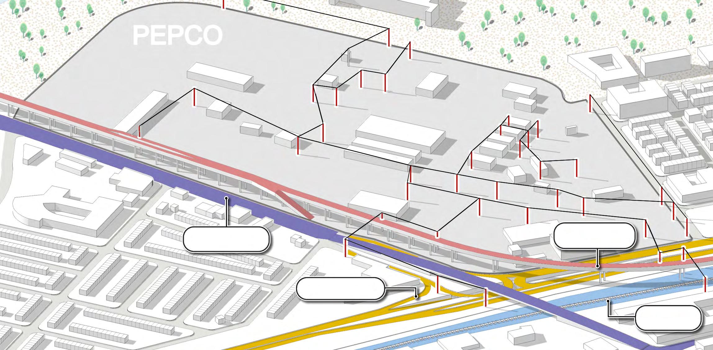
Exploring the PEPCO Site

How can a boulevard conversion can catalyze development - and not just any development, but equitable development? While this project is mainly about the highway conversion itself, it is useful to imagine how a lot of these ideas would ideally play out at a smaller scale through the example of one specific site.

To do this, we explored the PEPCO site located in the northern portion of our boulevard where Benning Road and DC-295 intersect. Within this small area plan, we wanted to achieve certain outcomes that align with the connectivity, ecology, and development frameworks we presented on earlier. These include: planning for a multi-modal future of mobility, creating new river connections and increasing accessibility to amenities, and increasing the corridor’s housing supply through a mixed-income neighborhood model.
This is by no means a final plan, rather, a suggestive imagination of equitable development that would be subject to change and evolution if taken through a rigorous process of community engagement and feedback. Our deep dives include materials for community members to run their own planning workshop at this site, similar to how we conducted ours.
The PEPCO site currently exists as 3 million + sq-ft of Production, Distribution, and Repair (PDR) land for DC’s electrical utility company, with large warehouses, pylons, and surface parking.
Page 60 Imagine a Boulevard
The PEPCO site situated towards the northern segment of the DC-295, adjacent to the Anacostia River and Parkside, Benning, and River Terrace neighborhoods.
Why this site?
Interaction with boulevard
The site interfaces directly with the proposed boulevard, and provides an opportunity to explore how the boulevard could affect future development.

Environmental reparations
Hosting non-renewable energy production and a trash-processing facility without proper controls of limiting pollution, the site has a history of environmental injustice and is a brownfield, providing the opportunity to explore ways to transform a polluted site into a community asset.
Access to Anacostia river
Sitting along the waterfront, PEPCO is a good location to explore how highway removal and equitable development can improve access to the river and river trail.
Over 3 million sq-ft of land
The site represents nearly 3.5 million square feet of development potential, which is an unprecedented amount of land and gives a lot of room for imagining possibilities.
Rethink industrial uses
The existence of crucial energy infrastructure on the site provided an interesting and timely development constraint. Energy providers, including
PEPCO, are already undergoing significant changes in their operations, and this site provides the opportunity to explore those changes in the short term.
Adjacent residential and commercial land use
The site is adjacent to varying residential and commercial typologies, meaning the site gives us the opportunity to think through what it would look like to develop with existing neighborhood characters in mind.
4 1 1 2 3 4 5 6 5 2 6 3
Page 61 Imagine a Boulevard
Existing Conditions
Road
Lines
Lines Page 62 Imagine a Boulevard
Benning
DC-295 MetroRail
CSX
Opportunities and Constraints
Opportunities
1. Proximity to Anacostia Riverfront
2. Direct access from Benning Road & DC-295

3. Adjacent to existing residential land uses
4. Close to Minnesota Ave station
5. Defunct CSX line in site
6. Brownfield remediation potential
Constraints
7. Floodplain
8. Existing roads and metro lines
9. Auto-oriented industrial land uses
10. Active CSX lines
11. Existing trash processing facility
12. PEPCO infrastructure
The planning process began with an identification of opportunities and constraints. This site presented challenges of a complicated intersection at Benning Road and DC-295, PEPCO’s electricity infrastructure, a trash facility at the northwest, and a storm surge line that cuts into the site. Conversely, it provided opportunities to better connect the neighborhoods of Parkside and River Terrace, strengthen the uses of developable land as community assets, and protect the river’s natural ecosystem.
Through our planning process and outcomes, we reiterate that the communities of and around this site know their needs best.
1 6 2 2 3 3 3 4 5 7 11 12 8 9 10 Page 63 Imagine a Boulevard
Extend transportation networks, move site boundary out of floodplain, and open up developable land
To continue the boulevard all the way through the corridor, it needs to be brought to grade with Benning Road at the place where they intersect. To bypass the existing metro lines running overhead and CSX lines below, we designed the road to curve into the site at the southeast corner. This would create large areas of developable land with unique opportunities for transit-oriented development.
We propose an extension of the H Street streetcar line across the Anacostia River down to Benning Metro Station with two additional transit stops: one on 34th Street at the main entrance to the site, and another at the Benning Road/Boulevard intersection. With this dedicated streetcar lane, Benning Road would get a Complete Streets treatment including protected bike lanes and pedestrian friendly infrastructure. To strengthen connections to Minnesota Avenue Metro Station, a station entrance should be added near Parkside, connected to existing MetroRail infrastructure through a short underground corridor.

Based on our research, we determined it was feasible to condense PEPCO utilities to about 750,000 sq ft in the middle of the site, retaining most existing transformers and buildings. We also made the decision that there would be no development built within the floodplain and buildings would be built accordingly to prepare for rising sea levels and storm surges. This still leaves a large amount of land for development surrounding the condensed PEPCO site.
Programming land uses to provide for mixed-use, mixed-income development
To develop the land to provide for mixed-income groups and create opportunities for upward mobility, a mix of uses catering to Wards 7 and 8, as well as DC at large is included. Entering the site through 34th Street at the south are dense, mixed use areas, which can be mid-rise buildings with mixed income apartments on top and retail at ground level. This is complemented with additional mixed use community assets closer to the waterfront - including affordable apartments, a health clinic and a small business incubator. Many of the commercial spaces on the site can be held for participants of the incubator program who need affordable space to grow their business ideas, such as restaurants, salons, and other small businesses.
Across Benning Road, a more unified commercial corridor with zoning regulations to restrict certain industrial related uses is proposed. This proposal accommodates existing auto related companies as part of a wider business retention strategy by consolidating footprints and creating a green buffer between them and the adjacent residential community. Lastly, an anchor grocery store would be located at the corner of the new intersection, making it accessible by car, transit, and bike from surrounding communities.
Reimagining PEPCO
A B
Page 64 Imagine a Boulevard
Planning for transit-oriented development and a spectrum of housing communities

To capitalize on transit-oriented development, the curved portion formed by the boulevard would be used for high-density, mixed-use buildings with commercial and hospitality, which is currently lacking east of the river. With an activated ground plane, this site can connect to neighborhoods across the CSX lines through thin “land bridges”.
To extend the boulevard’s philosophy of providing for people, place, and nature, green street networks are integrated across the site. The abandoned CSX rail that currently enters into the site would be extended into a wheelchair and bike accessible trail - directly connecting Minnesota Avenue Metro Station to the waterfront through the site’s green and public spaces. A community garden, farmers market, and tool library would anchor the eastern corner, directly accessible to Parkside and surrounding communities.
Near the waterfront, a new neighborhood of over 200 dense, attached single family homes, staggered in their height to provide views of the river, is proposed. Residents and visitors alike would have access to the riverfront and the site’s new amenities through neighborhood streets. Deeper into the site, a public park that could include a playground, picnic tables, and basketball courts for the neighborhood and those visiting the retail centers. Lastly, expanding the current trash facility to be an environmental education center and resilience hub, focused on building community stewardship for the Anacostia River would create another community asset.
Zoning and parking policies to support equitable, community-centered development
Since all development will be built on higher ground, parking for both commercial and residential uses would be located in underground parking lots to ensure walkability and pedestrian friendly streets. Parking garages in the single family homes would be built below grade in alleyways between the houses. This would allow for conversion to another room if owners do not have a car or act as floodable space that protects the rest of the home from future flooding. Parking for the environmental center would be the only “surface” parking lot, but would be programmed into a green parking lot with solar panels, permeable paving, and rain gardens.
To support holistic, equitable development across the site, several policy and zoning tools were explored. Changing the site to a ‘Special Purpose Zone’ can allow maximum density close to transit stops, as well as consistent design standards and an opportunity to preserve affordability. About 650,000 sq-ft of land in the northwest corner of the site could be given to the Douglass Community Land Trust to preserve affordability and maintain community control over the area. The site will also align with broader EcoDistrict standards, centering equity, resilience, and climate justice.
C D
Page 65 Imagine a Boulevard
Reimagining PEPCO

191st Street Underground Subway Entrance, NYC

Street Car Stop, Washington D.C.

Page 66 Imagine a Boulevard
Precedents
Section through Boulevard and TOD Complex


 Sims Municipal Recycling Facility, Brooklyn, NYC
Rendering of Potential ‘Green Parking Lot’ by Studio NAB
Below Grade Alley Parking in Single Family Homes, Los Angeles
Urban Market Grocery Store, Chicago
Michigan Business Incubator, Ann Arbor
Section through Commercial Avenue
The Goods Line, Australia
Sims Municipal Recycling Facility, Brooklyn, NYC
Rendering of Potential ‘Green Parking Lot’ by Studio NAB
Below Grade Alley Parking in Single Family Homes, Los Angeles
Urban Market Grocery Store, Chicago
Michigan Business Incubator, Ann Arbor
Section through Commercial Avenue
The Goods Line, Australia
Page 67 Imagine a Boulevard
Reimagining PEPCO

Environmental Resilience Center
Business incubator and ghost kitchen with residential above
Community restaurant with res above
Single-family residential Relocated autoservice zone Grocery store
Community center with tool-shed and library
Community gardens
TOD: offices and hotels
Land bridges
Defunct CSX rail to trail
Page 68 Imagine a Boulevard
How does this address the plan’s goals?


Plans for a multi-modal future of mobility, increases access to existing amenities, and strengthens connectivity between existing land uses.


Forefronts the river as a community asset, initiates environmental reparations, and creates a constellation of green networks.


Knits together existing land uses through compact, mixed-use development, increases mixed-income housing supply with zoning overlays to protect affordability, and creates a hub of transit-oriented development.

Page 69 Imagine a Boulevard
F.A.Q.’s 5
Frequently Asked Questions
Any project proposal of this scale will rightfully raise many questions, and answering them is an important part of any transparent and productive planning process. This section provides answers on some of the most likely questions surrounding a highway-to-boulevard project.

1: Won’t removing the highway make traffic in neighborhoods worse?
2: What is Bus Rapid Transit (BRT)?
3: How will this plan be inclusive of existing community members?
4: Won’t the demolition and construction process be disruptive?
Page 72 F.A.Q.'s
Frequently Asked Questions
worried about my commute. Won’t removing the highway make traffic in neighborhoods worse?
The first question on everyone’s mind with a project like this is “what about traffic?” It’s important to understand how the removal of 295 will impact congestion and traffic distribution, especially in neighborhoods east of the river.

I’m
Page 73 F.A.Q.'s
Frequently Asked Questions
Traffic volume
It is true that this project will substantially alter the flow of transportation generally in this area. The graph below shows that the replacement boulevard will be able to accommodate approximately 40% of the traffic volume seen on 295 today, once transit ridership has been accounted for. This is still much higher capacity than other local arterials like Minnesota Ave, which sees a daily usage of 10,000 cars, or about a quarter of the proposed boulevard’s capacity.[41] Roads like Minnesota may see an uptick in usage when the highway is gone.
2020 Traffic Volume of ARC Arterial Roads

NewBoulevard(proj.)


Congestion
However, congestion is by no means inevitable. Traffic is ultimately a question not only of road capacity, but the decision-making of travelers and the alternatives available to them. In Providence, Rhode Island, the relocation of I-195 out of the city center actually improved travel times in the region by 20%.[42] Although this project differs from the conversion of DC-295 into a boulevard in that it retained the presence of a high-capacity road, this dramatic reduction shows how much the right design choices can impact outcomes positively. In Seoul, the Cheonggyecheon project replaced 6.8 miles of highway that cut through the heart of the city with a boulevard and urban park, very similar to the Anacostia River Corridor. An academic study found that after an initial period of congestion, car trips on local roads decreased and subway trips increased.[43] These findings suggest that travelers are able to adjust their behavior even when the changes to the system are dramatic. The findings from Seoul emphasize the importance of transit alternatives. The conversion of DC-295 into a boulevard is a great opportunity to advocate for city-wide policies and transit improvements to encourage a mode shift away from cars over the lifespan of this project. D.C. is already making steps in the right direction; just this past month, D.C. City Council discussed the possibility of making the entire Metrobus system free for all residents.[44]
MinnesotaAve. BenningRoad E.CapitolSt.
-60% DC-295 Cars/Day 100,000 20,000 Cars Transit (BRT) 14,000 40,000 10,000
BEFORE Seoul AFTER BEFORE
AFTER
Providence
Page 74 F.A.Q.'s
Frequently Asked Questions
Travel times
In addition, it is important to point out that the highway was never meant to serve the residents whose homes it passes by in the first place, so removing it will not significantly impact residents’ commute times. In the example trip shown here from Fairlawn to Union station, the travel times differ by only a few minutes. An analysis of several other travel scenarios for local area residents found that using the highway rarely provides a travel time advantage over local roads, particularly for trips across the river.

The removal of the highway will, if anything, improve the commuting options for local residents by creating a much more robust transit network and increasing the number of connections across the river. Those most affected by the removal will be out-of-district commuters, who have a myriad of other options for getting into the city. Their behavior is flexible; the health and welfare of Ward 7 & 8 residents is not. To learn more about how the removal of DC-295 would impact traffic in the region, check out the “Traffic Analysis” deep dive.
Using highways: 12-24 minutes
rush hour:
Using local roads: 12-30 minutes
From Fairlawn to Union Station during
Page 75 F.A.Q.'s
Frequently Asked Questions
160,000
Current Ward 7 & 8 residents make up 1/5 of DC’s population.
And perhaps most importantly, the removal of DC-295 is ultimately about improving the lives of residents east of the Anacostia, and the potential benefits of removing the highway–better health outcomes, access to recreational space, connectivity, and more–far outweigh costs to out-of-district commuters. Wards 7 and 8 are home to 160,000 people–a fifth of DC’s population–who are all impacted daily by the highway’s presence.[45] In the 50-year lifespan of this project, the removal of the highway will benefit hundreds of thousands of DC residents.

Page 76 F.A.Q.'s
Frequently Asked
Questions
What is Bus Rapid Transit (BRT)?
Why chose this over other options?
Because of cost, time, and performance, a BRT system would be a significant upgrade from the existing conventional buses servicing Wards 7 and 8 that could bring connectivity, air quality, and congestion improvements to the surrounding communities.
 WMATA Buses in Washington, DC
Page 77 F.A.Q.'s
Frequently Asked Questions
The case for high-capacity transit
The District of Columbia lays claim to one of the nation’s top mass transportation networks, however compared to the rest of the District, there are visible differences in MetroRail and Circulator station locations, ridership, and last-mile connectivity for Wards 7 and 8 (East of the Anacostia River). There are a variety of ways to address the transit gap for residents, commuters, and visitors who need to travel north or south along the Anacostia River Corridor. Given the conversion of DC-295 will also necessitate a mode shift away from private vehicles, we recommend focusing transit investments on highcapacity transit along the Corridor. High-capacity transit refers to modes of transit that can carry a large number of passengers and requires “more frequent service, fewer stops, and faster travel speeds” than a regular bus system.[46] Transit systems that meet these criteria include bus rapid transit (BRT), light rail, underground subway, and streetcar.
The case for bus rapid transit (BRT)


While all four high-capacity transit options would be possible in the Anacostia River Corridor, a BRT system offers the benefits of high-capacity transit for a fraction of the cost and construction time.[47] Compared to a regular bus, a Bus Rapid Transit, or BRT, system is considered high-capacity transit in that it has more frequent service, fewer stops, and faster travel speeds. Other characteristics of BRT often include dedicated lanes, stations with shelter and seating, and off-board fare collection which makes quick, all-door boarding possible. The average time to construct a BRT system is one to two years, compared to two to three years for light rail and four to ten years for subway systems.[48] This means that a BRT running between the Deanwood Metro Station and Anacostia Metro Stations could offer new, high-quality connections for residents traveling north-south along the corridor within a year of DC-295’s removal. Despite being cheaper and faster to construct than light-rail and subway systems, BRT systems have a track record of attracting high levels of ridership, suggesting the District could meet the travel demands of the corridor following the conversion of the highway to a boulevard without investing in new railways. To learn more about bus rapid transit systems, check out the “Bus Rapid Transit” deep dive.


Page 78 F.A.Q.'s
Questions
How will this plan be inclusive of existing community?
There are several interventions that can be undertaken to ensure that the interests of residents and small businesses are represented in the development process. There are already a wealth of resources in DC including government initiatives and nonprofit organizations that are addressing community development and housing equity. We list here some potential partnerships and models that the River Corridor might consider in the future. The Housing Policy and Economic Resilience Deep Dives also provide a more in-depth analysis of opportunities to promote residential affordability and local jobs.
 dcist/Photo by Ted Eytan
Frequently Asked
Page 79 F.A.Q.'s
Frequently Asked Questions
Interventions for Businesses:
Business Incubator & Ghost Kitchen


Business incubators help train small business owners and subsidize the cost of starting a business using finances from the government and other funders. We propose the creation of a business incubator that will support a variety of small businesses. Specifically, the incubator would include a food hall, and spaces for ghost kitchens to lower the barrier to entry for local restaurateurs. Other amenities like coworking spaces will allow local entrepreneurs to collaborate and innovate without having to commit to expensive long-term leases for office spaces. Classes centering on entrepreneurship, financial literacy, and management will be held on-site.
Partnership with CDFIs
According to the US Department of Treasury, Community Development Financial Institutions (CDFI), are mission-driven financial institutions that utilize market-based approaches to support economically disadvantaged communities.[49] There are currently several CDFIs operating within DC and the River Corridor. Tapping into these resources, such as the Anacostia Economic Development Corporation, small business development resources (like technical assistance, capacity building) and financial resources (loans) can be leveraged to support local businesses.
Source: DC.org
Source: NPR
Page 80 F.A.Q.'s
Frequently Asked Questions
Interventions for Residents:
Special Zoning Overlay
The Special Purpose Zone designation creates a comprehensive set of regulations to guide the design and affordability requirements to promote community interests. Seven such zones have been designated throughout the District, including the Uptown MixedUse Art district.[50] A Special Purpose Zone can be placed on the PEPCO site to ensure affordability and preserve neighborhood characteristics throughout the development process.

Community Land Trust

A community land trust (CLT) gives ownership of properties (commercial and/or residential) to the community, instead of private developers. As land is opened up by the boulevard, a portion can be passed onto the Douglass Community Land Trust for them to develop and manage. This strategy will allow for the creation of affordable housing, enabling residents to build intergenerational wealth through homeownership without the fear of displacement.
Housing Production Trust Fund
Housing Production Trust Fund (HPTF) subsidies could be concentrated at neighborhood developments, such as the PEPCO site. Given the discretionary nature of DC’s Housing Production Trust Fund, the city should provide out-sized allocations to accelerate the implementation of the housing production plans at the PEPCO site. Large master-planned redevelopment projects can have difficulty attracting private investments and qualifying for financing. The HPTF can thus become a source of patient capital to jump-start the project to bring in more developer interest and equity investments.
Source: Coast-to-Coast/Getty Images
Source: Strong Towns
Page 81 F.A.Q.'s
Frequently Asked Questions
Active in the Anacostia River Corridor Today
Here are some of the organizations currently active in the Anacostia River Corridor. They serve as valuable models for Corridor-specific initiatives or partners.


PEPCO
Arlington Chamber of Commerce
News / COH
District Bridges
Petworth
DC Central Kitchen
1. DC Infrastructure Academy
2. Department of Employment Services
3. District Bridges
4. Community of Hope
5. Douglass Community Land Trust
6. DC Central Kitchen
Page 82 F.A.Q.'s
Frequently Asked Questions
Won’t the whole demolition and construction process be disruptive?

Park East Freeway Removal Project, Milwaukee, Wisconsin
Source: City of Milwaukee Department of City Development, Wisconsin via fhwa.dot.gov
Page 83 F.A.Q.'s
Frequently Asked Questions
Expected Impacts of Demolition and Construction

The following is a sampling of efforts that can be expected to reduce the impacts of demolition and construction. For additional information, please refer to the “Project Phasing and Impacts” Deep Dive.
1. Construction is estimated to take 3-8 years depending on construction model
2. 50% highway capacity maintained throughout the construction process
3. Minimal negative impacts on residents and businesses due to proactive programming, availability of local roads
4. Environmental impacts will be remediated in accordance with cutting-edge best practices
Bonaventure Expressway boulevard conversion in progress
Page 84 F.A.Q.'s
Frequently Asked Questions
Construction Remediation Strategies
The following remediation efforts could help reduce the impact of the construction process on the surrounding neighborhoods.
Streamline design-construction phasing.
One way to reduce the impact of construction is to shorten the construction period itself. This can be achieved by beginning demolition activities while design plans are still being finalized, which is referred to as a Design-Build process. Such a process was used in a major project in Seoul and reduced the project’s construction time significantly.
Advance environmental remediation best practices.
The “Project Phasing and Impacts” Deep Dive explores several ways to join the environmental remediation process together with the project’s ecological goals. This may include strategic use of soil and concrete waste produced by the project, and long-term management of erosion, runoff, and sedimentation.
Manage traffic through project phasing and rerouting.
One way to reduce the impact of construction on traffic patterns is to keep lanes of the highway open throughout the construction process. The Deep Dive also suggests directing traffic to nearby arterials such as Minnesota Avenue and keeping more lanes open during weekday peak hours.


Keep neighborhood fabric remediations net-affirmative.
The impacts on surrounding neighborhoods should be minimal; most demolition and construction will not occur within any neighborhoods, and will not displace any business or residents. However, it will still be important to launch health clinics, business relocation assistance, and home repair initiatives during an early phase of the project to keep resident buy-in high.
Page 85 F.A.Q.'s
CommunityDriven Process 6
Community-Driven Process
The research and materials prepared over the course of this Studio can be used to begin a community-led advocacy campaign around the future of DC-295. Here we imagine what a community-driven process could entail, and the benefits that could come from it.
A community-led process would:
1) Engage with River Corridor residents who are otherwise unlikely to participate in a planning process
2) Collaborate with existing advocacy networks and NGOs, and
3) Center community expertise to ensure meaningful community representation in discussions surrounding the future of DC-295.
In order to build and sustain the momentum of this effort, we believe that an advisory council should be formed. Advisory council members should live, work, worship, or play within the Anacostia River Corridor and be interested in seeing improvements in the area. This group could legitimize advocacy efforts, persuade local and citywide officials, and further educate area residents on the possibilities that arise with removing DC-295.
The council should also receive support from DC agencies to facilitate meetings and workshops and to access city resources. Through consultations with a variety of stakeholders, subject matter experts, and local business owners, the advisory group will ensure that they are making informed and representative decisions.
Other initiatives to promote local involvement might include walking tours, guest speakers, and community design workshops. The Community Partnerships Deep Dive provides a sample engagement plan which seeks to inspire next steps.


Case Study: Minneapolis Green Zone Northside Taskforce (Los Angeles, CA)
Launched in 2019, it addresses environmental justice issues in North and Northeast Minneapolis. Initiatives include designing and implementing a plan of action to improve environmental and population health, and social, economic and environmental justice.

Page 88
Final Deliverable Package
Our final deliverable package to the DC Office of Planning (DCOP) and DC Office of Energy and Environment (DOEE) aims to provide the needed information and tools to catalyze a communitydriven effort. These deliverables include a storybook, a portfolio of deep dive memos, and sample charrette materials.
We did our own charrette to come up with the site plan for the PEPCO site. The Sample Charrette Materials are intended to help the Anacostia River Corridor community do the same themselves, and develop a realistic development plan for a reimagined PEPCO site based on their needs and desires. We imagined this happening through a series of workshops, and made the materials so that they could be used to reimagine any number of sites along the Anacostia River Corridor, with the PEPCO site just being an example. Our hope would be that a community engagement process like that would be the next step in advocating around the removal of DC-295.

Page 89
The charrette materials can be used for community-driven conversations about the possibilities of highway removal.
Endnotes
[1] Stotts, Rodney, and Kate Pipkin. Bird Brother: A Falconer’s Journey and the Healing Power of Wildlife. Washington, DC: Island Press, 2022.
[2] King, Noel. “A Brief History Of How Racism Shaped Interstate Highways.” NPR, April 7, 2021. https://www.npr. org/2021/04/07/984784455/a-brief-history-of-howracism-shaped-interstate-highways
[3] Jaffe, Eric. “The Death Row of Urban Highways.” Bloomberg CityLab, November 2, 2011. https://www. bloomberg.com/news/articles/2011-11-02/the-deathrow-of-urban-highways
[4] American Lung Association. “Living Near Highways and Air Pollution,” November 17, 2022. https://www.lung.org/ clean-air/outdoors/who-is-at-risk/highways
[5] Congress for the New Urbanism. “Highways to Boulevards Fact Sheet,” n.d. https://www.cnu.org/ourprojects/highways-boulevards.
[6] City of Milwaukee Department of City Development. “Park East Freeway - History and Removal,” n.d. https://city.milwaukee.gov/DCD/Projects/ ParkEastredevelopment/Park-East-History
[7] The Rose Kennedy Greenway. “History of the Greenway,” 2023. https://www.rosekennedygreenway.org/history
[8] Seoul Solution. “Seoul Urban Regeneration: Cheonggyecheon Restoration and Downtown Revitalization,” April 21, 2017. https://www.seoulsolution. kr/en/content/seoul-urban-regenerationcheonggyecheon-restoration-and-downtownrevitalization
[9] District of Columbia Department of Health. “Community Health Needs Assessment (CHNA).” Vol. 2, March 5, 2013. https://doh.dc.gov/sites/default/files/dc/sites/doh/page_ content/attachments/2nd%20Draft%20CHNA%20 (v4%202)%2006%2004%202013%20-%20Vol%202. pdf
[10] ReadyDC. “Extreme Heat.” District of Columbia’s Homeland Security and Emergency Management Agency (HSEMA), n.d. https://ready.dc.gov/extremeheat.
[11] Hudson, Stephen. “DC’s River Tunnel Is Keeping Billions of Gallons of Sewage out of the Anacostia.” GGWash, August 17, 2020. https://ggwash.org/view/78760/dcsnew-tunnel-is-keeping-billions-of-gallons-of-sewageout-of-the-anacostia-2
[12] Bailey, Michael, Eric LaRose, and Jenny Schuetz. “What Will It Cost to Save Washington, D.C.’s Renters from COVID-19 Eviction?” Brookings, July 23, 2020. https:// www.brookings.edu/research/what-will-it-cost-to-savewashington-d-c-s-renters-from-covid-19-eviction
[13] Goldchain, Michelle. “Capitol Riverfront Will Break Even on Its $1B in Investments by Late 2018, Says Report.” Curbed DC, January 18, 2018. https://dc.curbed. com/2018/1/18/16903580/capitol-riverfront-navy-yardreport
[14] Lang, Marissa J. “D.C. Housing Costs Spiral as Muriel Bowser Runs Again for Mayor.” The Washington Post, June 16, 2022. https://www.washingtonpost.com/dc-mdva/2022/06/16/dc-housing-muriel-bowser-affordability/
[15] Office of Planning and Department of Housing and Community Development. “Housing Equity Report.” District of Columbia, October 2019. https://planning. dc.gov/publication/housing-equity-report.
[16] ARUP. “Future of Highways.” Arup Foresight + Research + Innovation, November 2014. https://www.arup.com/ perspectives/publications/research/section/future-ofhighways.
Page 90
Endnotes
[17] Rong, Blake Z. “What Will Our Roads Look Like in 50 Years?” Road & Track, October 31, 2016. https://www. roadandtrack.com/new-cars/news/g6843/the-road-ofthe-future/.
[18] George, Justin, and Ian Duncan. “D.C. Votes to Eliminate Metrobus Fares in Movement toward Free Transit.” The Washington Post, December 7, 2022. https://www. washingtonpost.com/transportation/2022/12/06/dccouncil-free-metrobus-vote.
[19] U.S. Department of Transportation. “Reconnecting Communities Pilot Program – Planning Grants and Capital Construction Grants,” October 14, 2022. https://www.transportation.gov/grants/reconnectingcommunities
[20] Wang, Claire. “Federal Highway Removal Program Raises Hopes in California.” The American Prospect, May 16, 2022. https://prospect.org/api/content/85a04d60d301-11ec-a3f3-12274efc5439/.
[21] Federal Emergency Management Agency (FEMA). “Building Community Resilience with Nature-Based Solutions,” 2021. https://www.fema.gov/sites/default/ files/documents/fema_riskmap-nature-basedsolutions-guide_2021.pdf
[22] U.S. Census Bureau; 2020 American Community Survey 5-Year Estimates. Retrieved from data.census.gov (October 2022).
[23] U.S. Census Bureau; 2020 American Community Survey 5-Year Estimates. Retrieved from data.census.gov (October 2022).
[24] U.S. Census Bureau. LEHD Origin-Destination Employment Statistics 2002-2019. Washington, DC: U.S. Census Bureau, Longitudinal-Employer Household Dynamics Program, accessed November 2022 at https:// onthemap.ces.census.gov
[25] District of Columbia, Office of Planning. “Anacostia Waterfront Framework Plan,” November 2003. https://planning.dc.gov/sites/default/files/dc/sites/ op/publication/attachments/The%20Anacostia%20 Waterfront%20Framework%20Plan%202003.pdf, 66.
[26] “Anacostia Waterfront Framework Plan,” 66.
[27] District of Columbia Department of Energy and Environment and Climate Ready DC, “A Vision for Community Resilience Hubs in the District of Columbia,” accessed December 13, 2022, https://doee.dc.gov/ sites/default/files/dc/sites/ddoe/service_content/ attachments/DC%20Resilience%20Hub%20 Program%201-Pager.pdf
[28] Perry-Brown, Nena. “The 17 Developments in the Works Between Anacostia and Buena Vista.” Urban Turf, May 12, 2022. https://dc.urbanturf.com/articles/blog/the-17developments-in-the-works-between-anacostia-andbuena-vista/19628.
[29] U.S. Census Bureau; 2020 American Community Survey 5-Year Estimates. Prepared by Social Explorer (October 2022).
[30] Institute for Transportation & Development Policy. “Getting to BRT: An Implementation Guide for US Cities - Institute for Transportation and Development Policy,” July 31, 2019. https://www.itdp.org/event/brtimplementation-guide-us-cities/.
[31] Institute for Transportation & Development Policy. “Getting to BRT,” 2019.
[32] The Federal Transit Administration (FTA). “Glossary.” TCRP Report 78: Estimating the Benefits and Costs of Public Transit Projects: A Guidebook for Practitioners, 2002. https://onlinepubs.trb.org/onlinepubs/tcrp/ tcrp78/glossary/L.htm.
[33] DDOT. “Plan Your Trip.” DC Streetcar, 2022. https:// dcstreetcar.com/plan-your-trip/
[34] U.S. Department of Transportation. “Traffic Calming to Slow Vehicle Speeds,” August 12, 2019. https://www. transportation.gov/mission/health/Traffic-Calming-toSlow-Vehicle-Speeds
[35] Urban Land Institute. “The Rondo Community Land Bridge, St. Paul, Minnesota.” ULI Advisory Services Panel Report. St. Paul, Minnesota, March 2018. https:// reconnectrondo.com/wp-content/uploads/2020/12/ ULI-Report-3.2018.pdf.
[36] Capital Bikeshare. “How Metro DC’s Bikeshare System Works,” 2022. https://capitalbikeshare.com/how-itworks
[37] Federal Transit Administration (FTA). “Transit-Oriented Development.” Accessed November 2022. https://www. transit.dot.gov/TOD#TODOverview
Page 91 Endnotes
[38] Federal Transit Administration (FTA). “Transit-Oriented Development.” Accessed November 2022. https://www. transit.dot.gov/TOD#TODOverview
[39] Redbrick LM D. “About - Bridge District,” 2022. https:// www.bridgedistrictdc.com/about/.
[40] Argerious, Natalie Bicknell. “Urbanism 101: What Is an EcoDistrict?” The Urbanist, July 2, 2022. https://www. theurbanist.org/2022/07/02/urbanism-101-what-is-anecodistrict/.
[41] District of Columbia Department of Transportation, “2020 Traffic Volume,” last updated September 16, 2022. https://opendata.dc.gov/datasets/DCGIS::2020traffic-volume/explore?location=38.894206%2C77.013050%2C12.54
[42] Sommer, Mark, “Is tearing down an elevated highway a good idea? Just ask Providence.” The Buffalo News, September 20, 2020, https://buffalonews.com/news/ local/is-tearing-down-an-elevated-highway-a-goodidea-just-ask-providence/article_c875c9b0-ebb0-11ea9533-cbf658a21faa.html
[43] Chung, Jin-Hyuk, and Keeyeon Hwang, “The loss of road capacity and self-compliance: Lessons from the Cheonggyecheon stream restoration,” Transport Policy 21 (May 2012), https://www.researchgate.net/ publication/254410384_The_loss_of_road_capacity_and_ self-compliance_Lessons_from_the_Cheonggyecheon_ stream_restoration
[44] George, Justin, “D.C. proposes free Metrobus service in city, expansion of major routes,” The Washington Post, December 1, 2022, https://www.washingtonpost.com/ transportation/2022/12/01/free-metrobus-rides-dc/.
[45] U.S. Census Bureau; 2020 American Community Survey 5-Year Estimates.
[46] RTC Of Southern Nevada. “High-Capacity Transit: The Secret to Traveling Efficiently.” Las Vegas Sun, March 15, 2018. https://lasvegassun.com/native/rtc-of-southernnevada/2018/mar/15/high-capacity-transit-the-secretto-traveling-effi/.
[47] Cervero, Robert. “Bus Rapid Transit (BRT): An Efficient and Competitive Mode of Public Transport.” Berkeley Institute of Urban Development, August 2013. https:// iurd.berkeley.edu/wp/2013-01.pdf.
[48] Cervero, Robert. “Bus Rapid Transit (BRT).” 2013.
[49] U.S. Department of the Treasury: CDFI Fund, “What Are CDFIs?,” accessed December 19, 2022, https://www. cdfifund.gov/sites/cdfi/files/documents/cdfi_infographic_ v08a.pdf.
[50] “Special Purpose Zones - General,” DC Zoning Handbook, 2022, https://handbook.dcoz.dc.gov/zones/specialpurpose-zones/.
Page 92 Endnotes
Anacostia River Corridor
Project Storybook
Executive Summary
December 23, 2022
