BY MIKE SMITH, RICH COLLINS, SOPHIE KASAKOVE AND BOB WARREN
The heaviest snowstorm to hit the New Orleans area in decades blanketed the region on Tuesday, shutting down roads, businesses, schools and air travel due to dangerously frigid conditions, but providing the rare opportunity for residents to frolic in a powderywhite winter wonderland.
By late afternoon, up to 9.5 inches and possibly more had fallen in New Orleans, surpassing a 1963 total that was second-highest and approaching the all-time record of 10 inches in the city and 11 inches in Jefferson Parish in 1895.
Heavy winds blasted the metro with sideways clouds of white, followed by calmer intervals of fluttering flakes, eventually completely obscuring roads and rooftops. New Orleans officials said residents could be snowed in until Thursday as they arranged for 14 snow plows on an emergency contract, initially focusing on the Crescent City Connection, followed
by hospitals, Louis Armstrong International Airport and other critical facilities.
Other areas of the state saw worse, with forecasters noting the potential for a blizzard in the Lake Charles area.
Gov. Jeff Landry pleaded with the public to stay off roadways, but not all were heeding the call. State Police reported 50 crashes statewide by midday as conditions rapidly worsened and roads became increasingly slick.
State and local officials were also warning of the danger ahead. Temperatures were expected to plummet Tuesday night and Wednesday morning into the low teens for many areas, with wind chills in the single digits in spots.
That presented the risk of frozen pipes and slick ice on roads, as well as hypothermia for those without shelter.
Sewerage and Water Board officials called
on New Orleans residents to run only a thin, spaghetti-size trickle of water through the faucet farthest from the home’s water meter. Excessive water use could tax the system, they said, while St. Bernard Parish specifically asked residents to conserve.
Power outages remained limited, though they had crept up some by early afternoon.
The relatively dry, powdery snow was blowing off tree limbs in many cases instead of weighing them down, but officials were watching to see if branches would begin snapping and falling on lines, especially with hazardous conditions slowing workers’ ability to restore power.
“What we just went through was the easy part,” Landry said at a mid-afternoon press conference, warning of the hard freeze ahead.
“The next 24-36 hours, we really need your help to stay off the roadways.”
‘Don’t think we want that’
As snowfall piled up in yards, on levees and in parks, residents took the rare opportunity to flop onto their backs to make snow angels, build snowmen and slide down levees on makeshift sleds. One group turned St. Charles Avenue into a winter sports course, strapping on skis to be pulled with ropes by cars along the stately, oak-lined roadway.
On the northshore, where some of the highest snow totals were predicted, the Waffle House on Florida Street in Mandeville was a beacon in a sea of white in the early hours on Tuesday.
Waverly Calamia, sitting at the counter and waiting for breakfast, said he and his wife planned to venture to Lacombe later in the day to make a snowman with their grandkids.
“They’ve never seen snow,” he said, digging into his grits. “They say we might get 8 inches. I don’t think we want that much.”
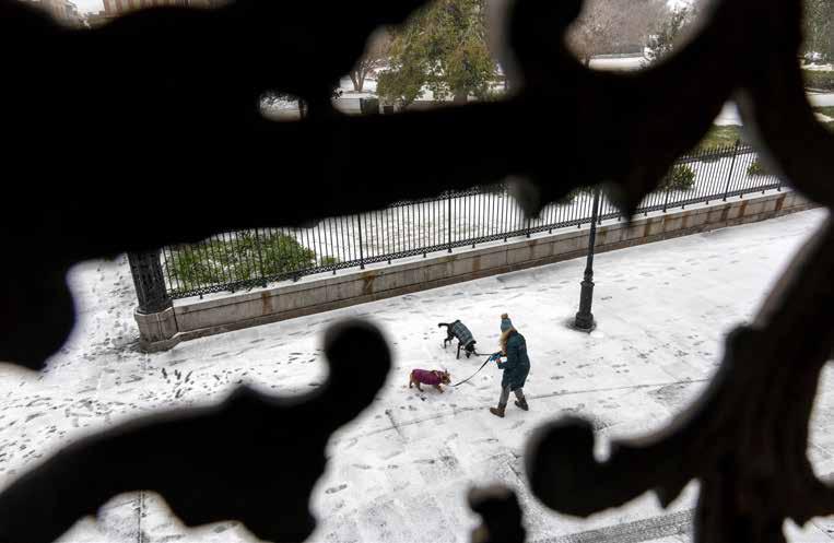
ABOVE: A view through a wrought iron balcony as people walk through the accumulating snow in the French Quarter of New Orleans during a rare snowfall on Jan. 21, 2025.
CHRIS GRANGER / THE TIMES-PICAYUNE | THE ADVOCATE
Schools throughout the region were closed and would remain so through Wednesday.
Louis Armstrong International shut down after all flights were canceled, with most airlines planning to return to normal operations Wednesday depending on conditions.
A long list of road closures were in effect, including all of Interstate 10 in Orleans, Jefferson and St. Charles parishes. The Lake Pontchartrain Causeway and the Crescent City Connection both shut down. By midday, Entergy was reporting around
out in the Covington and Slidell areas. That number was halved by midday at just above 300 still in the dark.
A boil water advisory for the Lower 9th Ward and New Orleans East was necessary after a brief, cold-related power loss at the Carrollton Water Treatment Plant late Monday afternoon, said Ghassan Korban, executive director of the S&WB. Testing found no threat to the drinking water and the advisory was canceled around 12:30 on Tuesday.
“We’ve now taken safeguards by keeping the place warm,” Korban said.
New shelter tested
For those without shelter, there were lifethreatening risks.
New Orleans officials opened the Treme Recreation Community Center after a warming shelter at the Rosenwald Recreation Center reached capacity.
3,500 outages throughout the state, with Orleans Parish accounting for a little over 200. Power cuts were intermittent and the largest in the metro area, which affected around 2,000 customers in Kenner early in the morning, was quickly resolved.
About 2,000 Washington-St. Tammany Electric Cooperative customers were out earlier on Tuesday, with most concentrated near the parish border north of Folsom. All but a handful were reconnected by midday.
Cleco also had several hundred customers
The snowstorm also came less than a week after state officials opened a temporary homeless shelter inside a Gentilly warehouse in an effort to clear the streets ahead of the busy Super Bowl and Mardi Gras tourist season. Some 173 people were staying at that shelter as of Tuesday morning, according to Mike Steele, spokesperson for the Governor’s Office of Homeland Security and Emergency Preparedness.
New Orleans City Councilmember Lesli Harris said Tuesday she remained concerned about conditions at the state shelter, which officials had struggled to keep heated. The rare winter weather resulted from a combination of timing and what is known as the polar vortex. Bitter cold dropped down
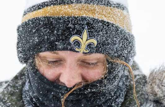
RIGHT: Keeping the New Orleans spirit alive, Dani Kennedy wears a fleur-de-lis snow hat while walking in the snow at Audubon Park during a rare snowfall in New Orleans on Jan. 21, 2025. CHRIS GRANGER / THE TIMES-PICAYUNE | THE ADVOCATE
OPPOSITE: Ellie Zurik laughs as snow accumulates on her eyelashes during a rare snowfall in New Orleans on Jan. 21, 2025. CHRIS GRANGER / THE TIMES-PICAYUNE | THE ADVOCATE
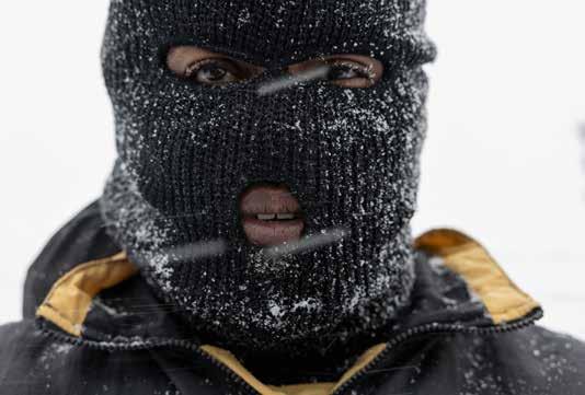
RIGHT: Johnnie Clark tried to cover every bit of exposed skin during a rare snowfall in New Orleans on Jan. 21, 2025. CHRIS GRANGER / THE TIMES-PICAYUNE | THE ADVOCATE
22, 2025
BY MATT BRUCE AND ELLYN COUVILLION
The historic snowfall gave way Wednesday to a record cold snap as Baton Rouge endured a second day of extreme weather.
Without snowplows and equipment to clear snow, the region relied on Mother Nature to defrost the snow and ice.
That didn’t bode well initially as Baton Rouge Metropolitan Airport recorded its coldest temperature ever and tied the second-coldest mark reported in the city with a 7-degree reading early in the day, the National Weather Service said.
Climate data for the airport’s Ryan Field go back to 1930, and Baton Rouge-area weather records date to 1892, the weather service said. After snow and bitter cold, the sun came out midday and temperatures climbed above freezing Wednesday afternoon to a high in the mid-30s.
The storm Tuesday dumped up to 9 inches of snow, the second-highest total in Baton Rouge,
trailing only a foot of snow that buried the region in 1895, said Hannah Lisney, meteorologist with the National Weather Service in Slidell.
Crews were able to reopen Interstate 10 westbound from Interstate 49 in Lafayette to the Texas border. But closures persisted on major interstate routes around the Baton Rouge metro area, including Interstate 110 and Interstate 12, as well as in the New Orleans metro.
Because of continued freezing overnight temperatures, residents should beware of fire hazards and black ice on the roads, Gov. Jeff Landry said in a news conference Wednesday afternoon.
Such precautions will help the state avoid tragic events, Landry said.
“We’ve got definitely two more nights of extremely cold temperatures,” he said. “If you do have to go on the roadways, be sure to go extremely slow.”
The rare snowstorm blanketed Louisiana and several Southern states. The big meltdown is expected Thursday when it warms to 46 degrees, and through the weekend when Baton Rouge residents will be rewarded with 60-degree weather.
In East Baton Rouge, areas like Oak Hills Place at the southern edges of the parish saw the heaviest totals in the region. Geismar was the most affected part of Ascension Parish with over 8 inches of snow, while Port Allen saw more than 7 inches. The outskirts of Denham Springs in Livingston got 6 inches, according to the weather service.
Bradley Benton, a Baton Rouge resident originally from Mandeville, was walking his two dogs, Milo and Nola, near downtown Wednesday. His dogs enjoyed Tuesday’s snow, but not so much Wednesday’s ice.
“My dogs loved the snow but they aren’t such fans of the ice,” Benton said.
Blankets of snow still cover several lanes at the I-10/110 split on Jan. 22, 2025, in Baton Rouge. MICHAEL JOHNSON / THE TIMES-PICAYUNE | THE ADVOCATE
He remembers the 2018 snowfall, but this week’s bitter cold is a completely different animal. “I don’t ever remember it being that cold here.”
Although Wednesday brought sunshine, temperatures remained chilly with a 35-degree high before they were expected to drop into the 20s at night.
“Basically, it’s a sheet of ice out there on the roadways,” said Lauren Nash, another National Weather Service meteorologist.
“It’s the travel impacts to watch for,” she added.
Flights have resumed at Baton Rouge Metropolitan Airport, with the first arrival landing Wednesday evening. Airport officials say the airfield is ready, and airlines will begin resuming flight operations Thursday morning. United Airlines’ first departure was scheduled for Houston at 7:15 a.m., according to airport spokesperson Kristen Jewell.
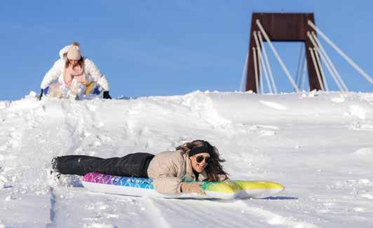
ABOVE: Summer Melancon, center, slides down the snow-covered Mississippi River levee with her sister, Macy, top, in Luling on Jan. 22, 2025.
BRETT DUKE / THE TIMES-PICAYUNE | THE ADVOCATE
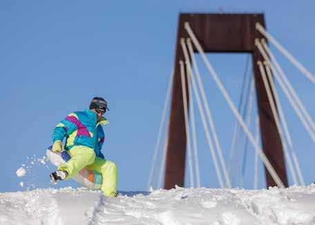
ABOVE RIGHT: The Hale Boggs Bridge stands in the background as Michael Melancon slides down the snow-covered Mississippi River levee in Luling on Jan. 22, 2025. BRETT DUKE / THE TIMES-PICAYUNE | THE ADVOCATE
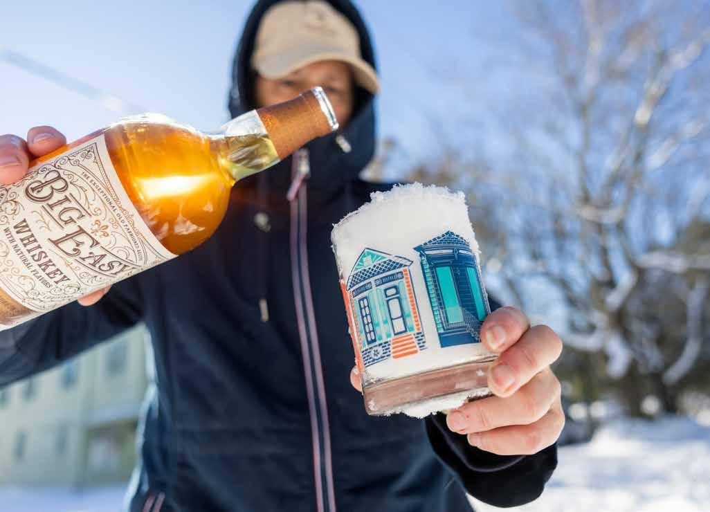
OPPOSITE: Using accumulated snow for ice, a New Orleans resident adds some Big Easy Whiskey to her drink to toast the rare snowfall in her neighborhood on Jan. 22, 2025.
CHRIS GRANGER / THE TIMES-PICAYUNE | THE ADVOCATE
RIGHT: Macy Melancon slides down the snow-covered Mississippi River levee in Luling on Jan. 22, 2025. BRETT DUKE / THE TIMES-PICAYUNE | THE ADVOCATE