Cabo la Huerta inglés

Page 1

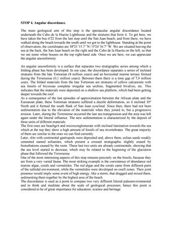
STOP 4. Angular discordance. The main geological aim of this stop is the spectacular angular discordance located underneath the Cabo de la Huerta Lighthouse and the stratums that form it. To get here, we have taken the bus nº22 from the last stop until the San Juan beach; and from there, we have walked along the beach towards the south until we got to the lighthouse. Standing at the point of observation, the coordinates are 38º21’15.7’’N / 0º24’16.7’’W. We are situated leaving the sea at the back, the San Juan beach on the right and the Cabo de la Huerta on the left; so that we see some white houses on the top right-hand side. Once we are here, we can appreciate the angular unconformity. An angular unconformity is a surface that separates two stratigraphic series among which a folding phase has been developed. In our case, the discordance separates a series of inclined stratums from the late Tortonian (8 million years) and an horizontal marine terrace formed during the Tirreniense (0,1 million years). Between them there is a time gap of 7,9 million years. The folded materials from the late Tortonian are stratums of yellow calcarenite with sea fossils of bryozoas complete irregular sea urchins, fragmented bivalves, etc. This indicates that the materials were deposited on a shallow sea platform, which had been getting deeper towards the roof. As a consequence of the last episodes of approximation between the African plate and the Euroasian plate, these Tortonian stratums suffered a ductile deformation, so it inclined 30º North and it formed the south flank of San Juan synclinal. Since then, there had not been sedimentation due to the elevation of the materials when they joined in, but a progressive erosion. Later, during the Tirreniense occurred the last sea transgression and the area was left again under the littoral influence. The new sedimentation is characterized by the deposit of three units of different materials. The first ones are beachgrit and microconglomerate with inclined lamination towards the sea which at the top they show a high amount of fossils of sea invertebrates. The great majority of them are similar to the ones we can find currently. Later, slits with continental gastropods were deposited and, above them, eolian sands weakly cemented named eolianites, which present a crossed stratigraphic slightly erased by bioturbations caused by the roots. These last two units are already continentals, showing that the sea level started to decrease, which may be related to the beginning of the glaciation phase that followed the Tirreniense. One of the most interesting aspects of this stop remains precisely on the fossils, because they are from a very varied fauna. The most striking example is the coexistence of abundance red marine algae, corals and vermétidos. The red algae and the corals came from different parts of the subtidal environment, while the vermétidos were developed on swell zones. Their joint presence would imply some event of high energy, like a storm, that dragged and mixed them, sedimenting them together by the highest area of the beach. The discordance is used as a point to compare two very different littoral paleoenvironmental and to think and meditate about the scale of geological processes; hence this point is considered to be of great importance for education, science and heritage.


STOP 5. Geomorphology. From the previous stop we continue about 100m. along the coast in South East direction (Alicante), until we reach the end of the cape, just below the Lighthouse (coordinates 38ยบ21'10.48''N / 0ยบ24'11.90''W). In this stop we are located in a wide esplanade from where we will observe the geomorphological elements caused by the action of the sea. The first thing that stands out is that here, the inclined stratums of Tortonian calcarenites are completely eroded, forming a gently sloping surface known as a wave-cut platform. This platform has two different coastal edges. On one side we find the coastal edge that has a sawed-off morphology, with inlets and salients, controlled by the stratums composition. Although in principle they are all calcarenites, we can observe that some levels have a thicker and harder grain size so they resist better to the swell. However, the inlets correspond to the softest materials and therefore, easily erodible, creating small rectangular beaches between the hard levels. On the other hand, from the cape to the West, the coast is arranged parallel to the bedding and therefore the erosive forms change, being more evident the relationship between the wave-cut platform and the micro cliff. Here we observe inlets due to the continuous action of the swell. They are getting deeper until the rocks of the cliff collapse producing their recoil. Over time a wave-cut platform is created. If we look closely we can distinguish inlets and platforms located at different levels. This phenomenon shows us that the sea level has been changing over time, or that the coast has risen. We also find forms caused by karstic weathering. On plain and horizontal areas, mainly in the wave-cut platform, it is common to observe small circular depressions called kamenitzas or microdolines. Its formation is related to the durable accumulation of water in areas with little slope. In addition around the surf edge (intertidal area) we observed very developed laples thanks to the presence of organisms that live close to the rock (cyanobacteria, algae, limpets, periwinkles) and that contribute to increase the dissolution since they acidify the medium. Also, in this strip, small reefs are developed as a result of the association between a calcareous algae and small colonial gastropods called vermetids (Dendropoma genus), which live fixed to the bottom. These reefs separate a small lagoon that is protected from the swell. It is home to a typical flora and fauna of sheltered environments which increase biodiversity. The vermetids are very sensitive to contamination and are legally protected. Finally, haloclastia also occurs on the walls of the cliffs. The calcarenite is moisted by the seawater whose salts plunge into rock pores producing a pressure able to disintegrate it. This process increases because of the geological action of the wind. The weathered particles transported, bombard and erode the surface. Both processes generate alveolar structures called alveoli and taffonis. In this environment there are evidences that explain the formation of the landscape that we observe and that is very beautiful.


STOP 6. Inlet formation. To reach our last stop we continue walking along the coast of Cabo de la Huerta, from the lighthouse to Alicante. In general, this is a quite straight coast because, as already described in the previous stop, it coincides with the stratums direction. The geomorphological structure of the wave-cut and micro-cliff platforms is highly developed. However, inlets appear every certain space, sometimes deep, in which inlets are developed more protected from the swell. Our objective in this stop is to explain the origin of these inlets. The stop is located approximately 850 m. away from the previous one (coordinates: 38ยบ21'10.38''N / 0ยบ24'46.23''W), a little beyond of Cala Palmera. We are located in a slightly higher concrete pivot, with the number 21 and looking at the sea. Below us we find a small inlet that seems to be in formation. What characteristics can we highlight that can explain their origin and possible development? The most evident is that there are a greater number of fissures (joints) and fractures (faults) than in adjacent areas. The fissures directions are grouped into two groups of different directions. Therefore these fissures cross each other and are technically called combined fissures. Both groups are associated to the main direction of the compaction that the Cabo has suffered, by which the strata are inclined, due to the progressive approach between the African and the Eurasian plates. It is through this joints network that seawater is transported, which hits a material that weathers faster thanks to a higher proportion of exposed surface. The swell removes and crushes the loose material so that the erosive action is always somewhat faster in the small inlets. As the inlet grows, the swell in it lose energy. Finally the inlet is stabilized and even becomes a deposition area that can develop small beaches. Over time, all areas with fissures will open up inlets and these will join and form larger beaches, leaving exposed only the least fractured and most resistant areas. Of course, if the tectonics continue compressing and raising the line, new families of joints will appear or those that already exist will be reactivated, what will make easier the erosion process. The importance of this stop is that the coast form is determined by the tectonic structures: where there are more fissures, the erosive action of the sea is favoured. The current arrangement of the inlets is determined by a structural control.


Issuu converts static files into: digital portfolios, online yearbooks, online catalogs, digital photo albums and more. Sign up and create your flipbook.