

Atlanta’s Citywide Trails Plan
June 3, 2025
Prepared for City of Atlanta on behalf of Departments of Parks and Recreation, Watershed Management, City Planning, and Transportation
Prepared by


Peachtree Creek Greenway, 2020


CITY OF ATLANTA
55 TRINITY AVE, S.W.
TEL (404) 330-6100
A Message from Atlanta Mayor Andre Dickens:
Atlanta influences everything. From standing as our nation’s cultural and civil rights heartbeat to driving groundbreaking innovations in sustainability – Atlanta is a beacon of progress. In a world facing immense challenges, Atlanta answers with action, showing the way forward by embracing solutions that benefit both people and the planet.
My administration is focused on building connections, fostering unity, and creating spaces where every resident can thrive. Trails ATL, the citywide trails master plan, is a powerful expression of this vision, reflecting our commitment to a healthier, more resilient, and inclusive Atlanta. From the Atlanta BeltLine to PATH 400, the Freedom Park Trail, and beyond – trails have connected neighborhoods, improved our health, and made our city more enjoyable.
Over the past few decades, Atlanta has shown the nation what’s possible when we invest in our environment and our communities. Today, we’re poised to take this vision to the next level. The City’s existing trail network currently spans over 80 miles, with another 25 miles in the works. These trails provide access to parks, schools, MARTA stations, and commercial areas. Right now, less than 40% of our residents have access to these important connections, but we can do better.
Through Trails ATL, we’re laying the groundwork to provide 94% of Atlanta’s residents with access to high-quality, all-ages, all-abilities trails that will make our city one of the most trailconnected in America. Atlanta is a group project, and Trails ATL is our shared mission. It is our blueprint to provide all Atlantans with the opportunity to experience the benefits of being outdoors, moving, and connecting with others. Whether walking, biking or simply enjoying our green spaces, these trails are where we’ll discover the beauty of Atlanta’s natural and cultural heritage, together.
We invite you to explore the Trails ATL vision and join us in making Atlanta a healthier, more connected, and sustainable city for generations to come – A City Built for the Future.

Sincerely, Mayor Andre Dickens


Executive Summary
Through the Trails ATL planning effort we have learned that Atlanta loves trails and wants more. This love is reflected in the data: the Beltline Eastside Trail averages more than 5,000 users per day; surveys show shared-use trails as the top priority for public investment; and 90% of Trails ATL survey takers express strong support for expanding the city’s trail network.
Atlanta’s last citywide trail plan was conducted by the PATH Foundation in 1992. Since then, Atlanta has built a safe and inviting all-ages, all-abilities trail1 network, soon to exceed 100 miles. Now, with the completion of the Atlanta Beltline a few short years away and with the needs to address climate change and health disparities becoming critical priorities, we are ready for the next step – an expansion of the network to bring the benefits of trails to all Atlantans - a project we’re calling Trails ATL
Which
Atlanta commute do you prefer?

Today, one in three Atlantans can access 81 miles of all-ages, all-abilities trails within a 10-minute walk or wheelchair ride from their homes with funding identified for another 34 miles of trails to be complete by 2029. Trails ATL calls for 420 miles of new trails including 140 miles of park-like greenways and 280 miles of protected street trails. When the network is complete it will provide 95% of Atlanta’s population with access to an all-ages, all-abilities trail within a 10-minute walk or wheelchair ride of their home. Phase 1 of the Trails ATL plan, detailed in Chapter 4, proposes 35 miles of new trails to be completed by 2037.
Atlanta Trail Network - Projected Growth in Mileage and Percentage of Residents with 10-minute Access

Atlantans were once defined by bad traffic.
Today, Atlanta defines itself in relation to the success of its trails
1. Be inclusively planned and designed.
2. Promote health and wellness for all, including, children, seniors and people with disabilities.
3. Enable safe, inviting and equitable access to parks, schools, transit and economic opportunity.
4. Enhance, showcase and connect us to the natural world.
Trails ATL is a City of Atlanta plan led by the Department of Parks and Recreation (DPR) with the non-profit PATH Foundation (PATH) as the hired consultant. Trails ATL staff conducted a community-wide planning effort with over 100 meetings in multiple formats and with a wide diversity of audiences across the city. It drew on the 34+ year trail building experience of PATH in collaboration with DPR, the Atlanta Departments of Transportation (ATLDOT), City Planning, Watershed Management, and the Atlanta Beltline. A technical advisory committee assembled from public and nonprofit entities provided guidance. Twelve thematically arranged focus groups contributed input based on their areas of expertise and more than 50 key stakeholder interviews were conducted. Community involvement was the cornerstone of the planning effort with four rounds of public meetings including presentations, Q&A, and opinion surveys.
Four Rounds of Community Involvement:
Trails ATL staff engaged the public in four rounds of outreach.
Round 1: Trails ATL asked “where do you want to go on trails and how do you want to get there?”2
The top five trail destinations generated during Round 1 of public engagement were:
1. Commercial areas
2. Parks
3. Beltline
4. MARTA
5. Schools
The public’s perceptions of various trail types from Round 1 of engagement were:
• 98% recommend park-like greenways
• 75% recommend a well-protected street trail
• 55% recommend a buffered bike lane
• <8% recommend an unprotected bike lane
Round 2: Trails ATL presented potential “trail opportunities” to the community. These were identified through extensive field work evaluated by city staff and vetted with the public in meetings held with the support of council members in their districts. The community weighed in via survey, web portal, meeting comments, and emails. Trails ATL staff assembled the feedback and adjusted the plan accordingly.
Round 3: Trails ATL went back to the community with a proposed citywide network reflecting feedback from the sources including public, the technical advisory committee and various stakeholders in focus groups and interviews. A preliminary Phase 1 trail list was shared in public meetings and surveys giving Trails ATL staff a sense of which trails were most wanted by the community. Surveys indicated a strong desire for greenways in underserved areas and a major concern that the trail network would not be built fast enough.
Round 4: Trails ATL staff met with city leadership to review the community input and the resulting proposed network. A more refined “Phase 1” trail list was reviewed by the elected officials in each council district. Trails ATL staff then presented the network and Phase 1 recommendations at each of the 25 Neighborhood Planning Units (NPUs) returning a second or third time to ask for a vote where 24 of 25 NPUs voted in favor of Trails ATL. The plan was presented at a public hearing of the Community Development/Human Services Committee and proceeded to the city council for adoption.
A Citywide Plan
Trails ATL is a citywide comprehensive (or “master”) plan. Details regarding specific trails including funding, timing, materials, design, exact alignment, lighting, cameras, etc. will be addressed in projectspecific plans with ample community engagement before implementation. For more information on Trails ATL communication, see Chapter 4.
Trails ATL Network
The 420-mile Trails ATL network expansion will transform Atlanta and provide safe and inviting allages, all-abilities access to 95% of Atlantans. While all trails will follow the guidelines laid out in Chapter 5, they are conceptually divided into two types:
Primary Trails
• Spine providing cross-town routes to major destinations like regional parks, train stations, high schools, colleges, and tourist attractions.
• Rely more on park-like greenways supported by protected street trails.
• Include pedestrian bridges and tunnels that connect neighborhoods across Atlanta’s many interstate and railroad barriers.
Secondary Trails
• Neighborhood-focused trails connecting to elementary schools, bus stops, and neighborhood commercial areas.
• Rely more on protected street trails and carefully considered shared streets.
• More likely to be along busy arterial roads as these are useful locally but less likely to be inviting to citywide users.
Phase 1 Implementation
The inclusive trail network will take many years to build and will require dedicated political leadership and enthusiastic public involvement. Trails ATL Phase 1:
• is a 10-year implementation plan for trail network expansion in all 12 city council districts.
• Consists of 23 projects and 35 miles of new trails.
• Cost estimate ≈ $252 M
Delivering the Plan
Trails ATL is an ambitious vision for combating many of the challenges faced by Atlanta, the nation and the world including climate change, social justice, housing shortages, health disparities, and ever worsening traffic congestion. Delivering the plan will require the City to leverage all its resources, coordinate across multiple departments, and collaborate with external entities including state government, non-profits, and advocacy groups.
To efficiently deliver Trails ATL and to ensure consistent collaboration across city government, the plan will be adopted into the City’s Comprehensive Development Plan (“Plan A”). Trails ATL trail alignments will also be recommended for the city’s zoning map and supporting documentation and will be a key part of the forthcoming Comprehensive Transportation Plan update.
While a detailed funding strategy is not in the scope for a plan such as Trails ATL, suggestions of how to pay for an expanded trail network such as by extending the Transportation Special Purpose Local Option Sales Tax (TSPLOST) or Mobilization, Optimization, Stabilization and Training (MOST) programs were discussed by members of the public and city leadership. Data points from the Round 3 Public Engagement Survey illustrate community support for increased public funding for trails –
• 90% of Trails ATL survey takers support expanding the trail network
• 85% of survey takers support using their tax money to expand the network
• 24 of 25 NPUs voted in favor of Trails ATL.
Trails such as the Atlanta Beltline, PATH 400, and the Proctor Creek Greenway have transformed what Atlantans perceive as possible in terms of recreation and transportation. Atlanta should take advantage of this unique moment to propel the vision for making our city the most trail connected in America.
Come help us build a green, healthy, happy and equitable Atlanta — one safe and inviting trail at a time.
Citywide Trail Network Plan

Phased Implementation Plan
Trails ATL Network
81 miles Existing network
34 miles Funded trails
35 miles Phase 1
63 miles Phase 2
322 miles Phase 3
535 miles Total network

2025
81 miles of trails 10-minute trail access for 37% of Atlantans

2037
150 miles of trails 10-minute trail access for 53% of Atlantans

2029
115 miles of trails 10-minute trail access for 43% of Atlantans
2052
535 miles of trails 10-minute trail access for 95% of Atlantans

Aerial view towards Midtown from Tanyard Creek Park and Atlanta Beltline Northside Trail
Vision & Guiding Principles
Trails ATL was created collaboratively with members of the public, key stakeholders, and technical experts. A core team consisted of staff from PATH, Parks, Planning, ATLDOT, Watershed and the Beltline. It was supported by a technical advisory committee including staff from other governmental agencies and community non-profits. For details regarding key staff and committee members, see page 21 and page 183 in the Acknowledgments.
Trails ATL envisions an Atlanta united by an evolving network of safe, inviting, and equitably accessible trails that nurture thriving neighborhoods and promote boundless exploration, active lifestyles, environmental health, and cultural enrichment.
Guiding Principles
Generated by Trails ATL staff and adjusted to reflect feedback from the public, below are the principles guiding the Trails ATL Plan:
• Be inclusively planned and designed
• Promote health and wellness
• Enable safe, inviting and equitable access to parks, schools and transit
• Link people to economic opportunity
• Enhance, showcase and connect us to the natural world
• Be enjoyable for children, seniors and people with disabilities
• Be accessible within a 10-minute walk or wheelchair ride of all Atlanta homes1
• Help City of Atlanta achieve park acreage and access goals
Goals & Success Metrics
Trails ATL, the citywide trail network expansion plan, builds on Activate ATL, the City’s comprehensive plan for parks and recreation. Activate ATL’s community involvement indicated that the public’s top priority for investment was paved shared-use trails1. In accordance with Activate ATL goals, the Core Team developed the goals, action items and key metrics below. These were vetted by the Technical Advisory Committee, focus groups, and in public meetings. See page 21 for planning team definitions.
Plan Goal #1: Plan and Build Atlanta Trails Equitably
Equity is critical to Atlanta’s identity and a goal requiring substantial commitment in the implementation of Trails ATL. Expanding Atlanta’s trail network will require significant public and private investment and will have a noticeable impact on streets, parks, neighborhoods, and travel behavior. Given these impacts, all neighborhoods and social groups must be invited to weigh in on various aspects of the plan including where trails go, what they look like, and when and in what order they are constructed. Building trails equitably requires
• Confirmation that, broadly speaking, trails are desired, where they should go and what they should look like;
• Identification of specific trail opportunities supported by the public;

• Development of a trail network giving priority to parts of the city that have lacked public and private investment while recognizing the need for geographic balance across the city; and
• Approval of a plan that reflects public input and responds to public feedback.
Plan Goal #2: Provide 10-minute trail access to 50% of Atlanta residents by 2037
Trails are built for people to use for recreation and transportation. To be equitable, but also in awareness of the city’s historical development patterns, these trails should be accessible to all Atlantans. Today’s network of existing trails reaches about 37% of the population. While the overall trail network envisioned by this plan will cover close to 95% of the population, an interim achievable goal is to get to 50% coverage within 10 years of the start of the funding strategy, which for planning purposes is assumed to be 2027. The action items listed below are derived from Plan Goal #2.
• Brand and market an expanded trail network;
• Develop funding strategy for grants, local funding, and donations to build 35 miles of trails;
• Plan for building 6 miles of new high-quality street trails; and
• Plan for building 29 miles of new greenway trails in Atlanta.
Success Metrics
Generated by the Core Team, vetted by the advisory committee and focus groups, and shaped by public input during community engagement, below are key performance indicators addressing equity, trail network coverage, trail network access, and program efficiency for the trail network after plan adoption:
• How well do trail investments support “communities of concern” as defined by ATLDOT?2
• What percentage of Atlanta residents have 10-minute access to the trail network?
• How well does the trail network access commercial areas, parks, the Beltline, MARTA and schools?
• How many more miles of the trail network are complete in a given year or in five year increments?
Bike riders in Westside Park, August 2024
Planning History
While Trails ATL is only the second citywide trail plan, it follows many years of planning in support of safe and inviting places for people to walk and roll. Over the years, Atlanta planning has become more robust and data driven creating more opportunities for public involvement. The following list names some fo the plans consulted in the making of Trails ATL.
City of Atlanta Greenway Trail Corridor Plan – 1992
Atlanta’s first trail plan was conducted by a nascent PATH Foundation in 1992 as part of planning for the 1996 Olympic Games.
While simple in structure, this visionary plan and its implementation have been transformative. The backbone of the city’s existing trail network was laid out including what today are known as the Beltline, PATH 400, the Eastside Trolley Trail, the Stone Mountain Trail, Freedom Trail, Chastain Park Trail, the Southtowne Trail, the Lionel Hampton Trail, the Peachtree Creek Greenway, etc. Other trails are in the process of implementation including the Riverlands Trail and the Adams Park Trail (previously known as Aero ATL). Still others of the 1992 trails carry forward into the proposed Trails ATL network including the Terrell Creek Greenway (shown as the Hollywood Trail), the North Atlanta Trail, and the South Atlanta Greenway. Leveraging unused rail lines, working with developers to bring new amenities, and collaborating with neighborhoods to provide access to schools and parks were all learnings from implementing the 1992 plan.

Stipulations for use of the parcels include, “. . . no more than 10% of the area of Greenway Properties acquired may be developed for public access or use, such as bicycle and hiking paths;” and “Any infrastructure for human activity within the Greenway Properties shall be designed and constructed with prevention of non-point source pollution as the primary consideration”.
The Trails ATL Plan proposes greenways along several of these Consent Decree properties and will need to go through the approval processes of the EPA and the Department of Watershed Management (acting as EPD’s enforcement arm) to gain permission to build them.
Atlanta Beltline – 2005—20244
Greenway Acquisition Plan3 –(Consent Decree) – 2001
The Greenway Acquisition Plan was undertaken in connection with the settlement of an enforcement action taken jointly by the United States Environmental Protection Agency (EPA), the Georgia Environmental Protection Division (EPD) and Upper Chattahoochee Riverkeeper Fund, Inc., the Chattahoochee Riverkeeper Inc., and W. Robert Hancock, Jr., for violations of the Federal Water Pollution Control Act and Georgia Water Quality Control Act. As part of this settlement, the City of Atlanta was required to purchase streamside properties to maintain healthy vegetated buffers that protect against erosion and non-point source pollution. These properties are known as “Consent Decree Greenway Properties.”
Born in the “Rail-to-Trail”movement of the late 1980s, christened in the 1992 Greenway Corridor Plan, and expanded to include transit and economic development in 1999 by Ryan Gravel’s thesis, the Beltline has transformed Atlanta. The 22-mile loop of trails, parks and transit has allowed Atlantans to experience the health, wellness, financial, and transportation benefits of trails. Planning for the project includes 10 sub-area master plans that address land use and transportation (including trail connectivity) to and through the Beltline. Originally completed in the late 2000s, the sub-area master plans have nearly completed their second round of updates. These neighborhood level planning efforts are valuable in guiding a bigger vision for the Beltline beyond just the trail corridor. Atlanta Beltline planning and community involvement has been exemplary, and Trails ATL has been inspired by their clarity and efficiency in communications.
3 https://drive.google.com/file/d/1kY-1csSkZYSn8vBdJKalZ-oxGo6vJjhj/view 4 https://Beltline.org/learn/progress-planning/subarea-master-plan/
Cycle Atlanta – 2014—2018
Cycle Atlanta was a planning strategy in two phases. Cycle Atlanta 1.01 was conducted in 2013 as part of the Connect Atlanta Transportation Plan. It was focused on connecting residents to the Beltline from the core of the city in 31 miles of trails across five corridors with multiple parallel alignments. A number of these plans have come to fruition or have been programmed for near-future work. This document inspires Trails ATL to think in terms of a network using streets modified for safe biking and walking and to consider the value of multiple parallel alignments to provide wider access for trail users.
Cycle Atlanta 2.02 was conducted in 2018 as part of the Atlanta Transportation Plan. It proposed 43 miles of trails in a wide variety of formats focused on providing access to MARTA Stations. This plan inspires Trails ATL to think of the critical nexus between transit and trails – each supporting the other in the creation of safe, inviting and efficient travel networks that do not require travel by car.
Atlanta City Design3 – 2017
This is a vision for the city based on the concept of the “Beloved Community” spoken of by Dr. Martin Luther King Jr. The Atlanta City Design anticipated a massive boost in the city’s population in coming years and provided high-level strategic guidance on how to effectively manage the influx without losing the city’s identity. Solutions include a connected trails vision (also referenced on page 87 in Activate ATL). This document is the inspiration for Trails ATL greenway proposals along North Utoy Creek, South Utoy Creek and Camp Creek. Other proposed greenways along Nancy Creek and Peachtree Creek in Buckhead are not included in the plan as they are not feasible due to land ownership.
Walk Bike Thrive4 – 2017
The Atlanta Regional Commission (ARC) plays a vital role in coordinating public investments across the Atlanta region –including trails. Created under the leadership of the ARC in support of The Atlanta Region’s Plan, the Walk. Bike. Thrive! plan supports the general need for safe walking and bicycling infrastructure to increase travel choices for residents and to guide the Atlanta region in overcoming existing barriers to active transportation. The goals involve expanding safe and accessible walking and bicycling options to make Atlanta “one of the most walk-friendly and bike-friendly regions in the country.” This is to be accomplished by focused investments, addressing safety and equity issues, partnering with transit providers, and maintaining momentum by pursuing “relentless incrementalism.”
The ARC’s plan inspired the Trails ATL Plan to think regionally regarding how the city’s trail network plays a vital role outside the city as well.


1 chrome-extension://efaidnbmnnnibpcajpcglclefindmkaj/https://altago.com/wp-content/uploads/Cycle-Atlanta-Phase-1.pdf
2 chrome-extension://efaidnbmnnnibpcajpcglclefindmkaj/https://www.atlantaga.gov/home/ showpublisheddocument/47911/637341318187570000
3 https://www.atlcitydesign.com/
4 https://atlantaregional.org/what-we-do/transportation-planning/bicycle-pedestrian/bike-pedestrian-plan-walk-bike-thrive/
Cycle Atlanta Map 1.0
Regional Trail Map, Walk Bike Thrive
ATL Connected Trails Vision Map
North Buckhead Signature Streets – 2022
The North Buckhead Signature Streets Plan was a collaboration of the Buckhead Community Improvement District and the North Buckhead Civic Association. Building off the 2015 North Buckhead Master Plan, the Signature Streets plan aimed to address safety issues and improve the experience of biking and walking for those seeking access to neighborhood destinations such as PATH 400, the Blue Heron Nature Preserve, and the commercial areas in Buckhead. The plan used a placemaking strategy to bring together neighbors in support of the creation of “beauty, fun, and identity.” Trails ATL was inspired by the Signature Streets Plan in its substantial community engagement, thoughtful repurposing of the public realm, and commitment to neighborhood values. Segments of the Wieuca Trail, the Dunwoody Trail, and the Chastain 400 Trail are attributed to the public trail planning process and the involvement of North Buckhead residents.
Cascade Heights Greenway Network Study – 2023
The Cascade Springs Nature Conservancy (CSNC) conducted the Cascade Heights Greenway Network Feasibility Study, which prioritized eight shared-use trail corridors in southwest Atlanta. This initiative relied on community engagement and data analysis while building on local knowledge and grassroots advocacy. The planning team collaborated with the Atlanta City Studio to create a vision for equitable access to parks and mobility infrastructure. This effort resulted in the ongoing construction of the “model mile” sidepath trail along Cascade Road.
The Cascade Heights Greenway Network Feasibility Study has inspired Trails ATL to enhance community engagement and improve understanding of the opportunities at the intersection of equity, ecology, and mobility. This has fostered community acceptance of and appreciation for the value of trails. The study serves as a foundation for the citywide plan in southwest Atlanta. Several segments of the Emerald Utoy Greenway, the Emerald Cascade Greenway, the Adams Park Trail, and the extension of the Lionel Hampton Trail are attributed to the public planning process
Vision Zero5 – 2023
Responding to growing awareness of traffic fatalities and serious injuries (more than 300 over the last three years) in Atlanta, ATLDOT is administering a Vision Zero program focused on “the safe system approach” that uses proven strategies to reduce the impact of “traffic violence.” Vulnerable road users (wheelchair users, bicyclists, pedestrians, etc.) in communities of need are put center stage with the result that the city is investing in safe street crossings, slowing motorists down, and paying attention to safe routes to school. Trails ATL is inspired by this work to consider how trails can provide safety-focused travel alignments that encourage people to bike and walk away from “high stress streets” – streets with a greater number of potential trail user/ motorist interactions.


Cascade Heights Network Map
Buckhead Signature Streets Map
Activate ATL – 2021
The city’s approved comprehensive parks and recreation master plan is a 10-year master plan to address disparities within the parks system by equitably investing in and better connecting communities served. It also has an ambitious goal to grow the city’s parks score by acquiring 2,750 acres of land for park expansions. In an analysis of top priorities for investments evaluating the unmet need cross-referenced with the importance to residents, paved shared-use trails were the top priority for investment in all four quadrants of the city. With strong mayoral support, the City of Atlanta has policies reflecting the Trust for Public Land’s “10-minute walk to a park or greenspace” campaign. Trails ATL is inspired by this thoughtful and useful plan to think of greenways as linear parks – not only within a particular park but also between parks. Acreage set aside via easement or purchase for the creation of trails can contribute substantially to Activate ATL’s park land acquisition goals while also activating some existing park properties that lack safe and inviting non-car access.
Plan A1 – forthcoming in 2025
Originally approved in 2021, the Department of City Planning is currently conducting an update to the Comprehensive Land Use Plan – “Plan A”. This plan ties together the relationships between land use, transportation, housing and economic development. The Trails ATL plan similarly touches the city on multiple fronts by connecting residents between their homes, work opportunities, parks, social spaces, and schools. Trails ATL is inspired by Plan A’s broad-based and inclusive approach to implementing the changes needed to achieve the city’s goals related to equity, climate resilience and city design. Trails ATL will be adopted as part of the Comprehensive Development Plan. A related project being undertaken by City Planning is the Zoning Code Update. Trails ATL alignments and supporting text will become a part of this document. Including sufficient detail from Trails ATL in both Plan A and the Zoning Code Update will help align the Trails ATL network with future development and other public investments.

Comprehensive Transportation Plan Update – 2025—2026
Beginning in 2025, ATLDOT will conduct its five-year update to the Comprehensive Transportation Plan. The forthcoming update aims to identify street typologies and key transportation needs while supporting growth in active transportation infrastructure. Trails ATL will be a key input to the CTP plan, and it is intended that some of the street trails laid out in the Trails ATL Plan will be further refined in collaboration with neighborhood planning efforts.
Planning Process
Trails ATL was coordinated through various city departments and key stakeholders with experience in or valuable perspectives on shared-use trail development in four rounds of community involvement over 18 months from January 2024 to June 2025.

Core Team (Met Bi-Weekly):
Staff from:
Parks & Recreation
Atlanta DOT
City Planning
Watershed Management
Beltline
Topics
- Review fieldwork data.
- Guide and make decisions.
- Support public involvement efforts.
Focus Groups (Met 2 times):
Commercial Improvement Districts
Colleges
Housing
Mayor’s Office
Nature
Parks
People with Disabilities
Police
Schools
Social Advocacy
Topics
- Review data presented by lead consultant.
- Share future plans related to trails.
- Provide expertise-related feedback.
Technical Advisory Committee (Met 5 times):
Parks & Recreation
Atlanta DOT
Atlanta Beltline
City Planning
Mayor’s Office
Atlanta Public Schools
Atlanta Housing Authority
Park Pride
Propel ATL
Georgia DOT
Atlanta Regional Commission
Conservation Fund
MARTA
West Atlanta Watershed Alliance
Shepherd Center
Topics
- Review data presented by lead consultant.
- Provide detailed feedback on technical aspects of plan.
- Support public involvement efforts.
- Review and give feedback on Report.
Key Stakeholders (Met 1 or 2 times):
City Council Members
Activity groups
Advocacy groups
Atlanta Planning Advisory Board
Neighborhood groups
Atlanta Urban Development Corp
“Friends of” park groups
MARTA
Greenspace Advisory Committee
Real estate developers
Topics
- Review data presented by lead consultant.
- Provide feedback and share future plans.
- Support public involvement efforts.
Community Involvement Structure
The community was deeply involved in the creation of the Trails ATL plan. Outreach was consistent over the course of 2024 and 2025 and was organized in four rounds.
Round 1
Key Questions - Where to go & How to get there?
Round 1 public involvement ran from March to June 2024. The goal was to get answers to the key questions: (1) where do you want to go on trails and (2) what type of trails do you want to take to get there.
Involvement Methods
Trails ATL staff, with support from the Core Team and Technical Advisory Committee (TAC), decided on a three-prong strategy:
1. Partner with City Planning on their outreach efforts related to the update of the Comprehensive Development Plan. Trails ATL staff attended all 13 in-person “Plan A” public meetings covering all 25 of the City’s Neighborhood Planning Units (NPUs). Staff showed maps of relevant NPUs with the existing trail network and engaged in discussions regarding desired destinations and trail types.
2. Conduct in-person and virtual meetings in English and Spanish in five zones: NE, NW, SW, SE, plus a carve out for Midtown and Downtown highdensity districts.
3. Deploy Round 1 survey from March 11 through September 30 – a timeframe covering all of the NPU meetings and general public meetings.
Round 1 Results
The planning team received answers to the key questions via input gathered at the public meetings and 1,479 survey responses. The top five responses to “Where do you want to go on trails?”:
1. Commercial areas
2. Parks
3. Beltline
4. MARTA
5. Schools1
Most and least recommended trail types:
• 98% recommend park-like greenways
• 75% recommend a well-protected street trail
• < 8% recommend an unprotected bike lane


Round 1 NPU meetings
1 Calibrated for people with children 18 or younger living at home.
Round 2
Key Question - What do you think about the trail opportunities presented?
Round 2 community involvement ran from June through August 2024. The goal was to engage the public with the results from field work and plan review, by way of maps showing “trail alignment opportunities.” These opportunities were vetted for constructability, elevation change, property ownership, potential traffic impacts and potential environmental impacts. City Council Members were briefed on the opportunities and then were engaged to lead and support public meetings in their respective districts.
Community Involvement Methods
Trails ATL staff, with support from the Core Team, TAC and City Council Members conducted inperson public meetings in each of the twelve city council districts. Additionally, virtual meetings were held in English and Spanish. Trails ATL staff gave presentations with informative slides, made time for

Q & A, and presented maps where attendees were invited to add their opinions about trail alignment opportunities.
The Round 2 survey accompanied this outreach effort and was active from June 19 to September 30, 2024. 400 people responded.
Round 2 Results
Trails ATL staff analyzed the survey responses. Of those engaged, 91% indicated that “The City should make building trails a priority.” The most important prioritization metrics were (1) build trails in areas that do not have them, (2) build trails that serve the most people, and (3) extend existing trails. Written responses to the trail opportunities were generally very positive, implying that respondents were enthusiastic about the scope of the expansion of the trail network. Respondents expressed concerns about crime, property impacts, and environmental impacts in that order.


District 6 Public Meeting in Piedmont Park, June 2024
Council District Map of the City of Atlanta Round 2 - Public Meetings held in each District
District 9 Public Meeting, July 2024
Round 3
Key Question - What do you think of the proposed Trail ATL network?
Round 3 community involvement ran from September into November 2024. The goal was to share with the public the results of the planning effort to date – including modifications to the trail opportunities presented in Round 2. From this modified list, Trails ATL staff presented maps and information showing the proposed Trails ATL network expansion and the Preliminary Phase 1 Implementation Plan. Round 3 presentations highlighted 30 trails that could conceivably be built in 10 years.
Involvement Methods
Trails ATL staff, with support from the Core Team and TAC, made presentations to three clusters of four city council districts in virtual public meetings held in midOctober 2024 – with a Spanish version that covered the entire city. These meetings also included polls asking questions of attendees in real time. The Round 3 survey conducted as part of the outreach effort was active from October 14 to November 7, 2024. 864 people responded.
Round 3 Results
From poll questions and public comments taken during the Round 3 public meetings, 88% supported linking together the city’s parks with shared-use trails. The top three concerns listed were (1) trails won’t get built fast enough, (2) maintenance after the trails are complete, and (3) user safety in relation to crashes.
From the survey, 85% of those engaged were supportive of additional taxes to pay for expanding the trail network.
Round 4
Round 4 community involvement was conducted from February through June 2025. It included substantial outreach to neighborhoods (via the Neighborhood Planning Unit process) regarding this report and its contents. Trails ATL staff attended monthly NPU meetings in Spring 2025 that included presentations with maps highlighting community trails. The goal of these meetings was to keep the public informed about the status of the plan, offer opportunities for feedback on the report, and ultimately to vote whether or not to support the plan. 24 of 25 NPUs voted in favor of Trails ATL.
Following a public hearing on June 4, 2025 the Community Development and Human Services Committee was to have voted for approval on June 10.


Round 3 Clusters of City Council Districts - West, North, South - East
Round 4 Neighborhood Planning Units Map
Plan Promotion Tools
Website
www.trailsatl.com was launched prior to public involvement in March 2024. It provided access to information regarding the benefits of trails, meeting times and locations, a survey portal, copies of previous public presentations, videos, an FAQ and a communication link for questions and comments monitored by Trails ATL staff. The site is also hosting all Trails ATL documentation through at least 2026.
Yard Signs
Trails ATL staff posted over 200 yard signs around the city at parks, schools, trailheads and other visible locations to generate interest in the plan. A QR code provided a direct link to the website. Many meeting attendees indicated they had seen these signs.
Social Media
Staff posted frequently on social media through PATH Foundation and Parks Department platforms providing information about meetings, trail benefits, and promotions to take the surveys in the first three rounds of community involvement.
Flyers
Flyers were printed and shared at the public meetings for all rounds of public involvement. These were also provided to recreation centers and given away at pop-up events.
Email Broadcasts
Email blasts were done in collaboration with various city departments. City council members, advocacy organizations such as Propel ATL, and activity groups like the Nature Gurlz also sent links to the website and survey via their email distribution lists.
Pop-Up Events
Trails ATL staff attended a variety of pop-up events typically conducted by city departments such as the Mayor’s Office of Immigrant Affairs, ATLDOT Streets Alive events and the Department of City Planning.
Monthly NPU Meetings
Trails ATL staff promoted the Plan and encouraged attendance of planning events during the monthly meetings held by each of the 25 neighborhood planning units (NPU).


PATH trail planner at Streets Alive Pop-up event on Peachtree St.
Pop-Up Outreach at “Mayor’s Office of Immigrant Affairs event.
Trails ATL website

02 TRAIL OPPORTUNITIES
Joyful parade on the Freedom Trail
Chapter 2 lays out the process used to identify trail opportunities that were then shared with the community. It describes existing conditions for protected shared-use trails, reports responses from the public on key questions regarding trail use, assesses Atlanta’s geography for greenway and street trail opportunities, and shares the findings of the evaluation of Round 2 of public involvement.
Atlanta’s Existing Trail Network
Below are definitions for terms describing Atlanta’s protected shared-use trail network.
Existing
Protected
Shared-use
Trail
10-minute access
Approximately 81-mile network of protected shared-use trails providing 10-minute walk or wheelchair access to 37% of Atlanta residents.
Vertical physical separation between trail users and vehicle traffic such as curbs, traffic barriers, guard rails, parked cars, trees, planter boxes, etc.
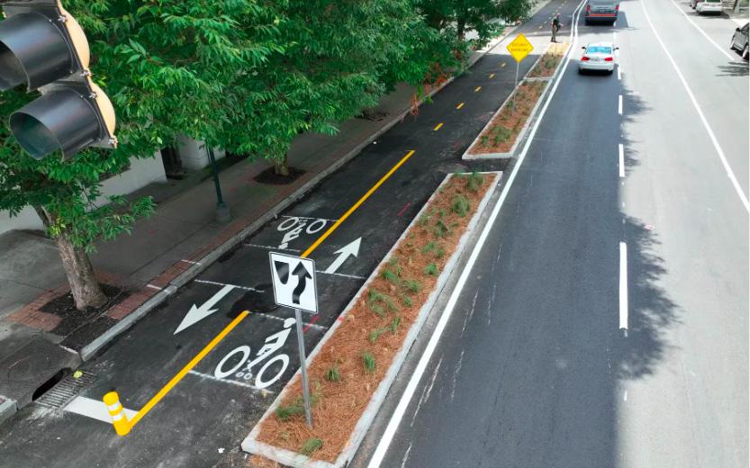
All-ages, all-abilities trails designed for (1) pedestrians – wheelchair users, stroller pushers and people walking; (2) users of light individual transportation (LIT) such as bicycles, e-bicycles, scooters, skateboards, roller skates, etc. The plan refers to “LIT users” and “walking and rolling” as shorthand.
In the context of this plan, trails are 10-14’ wide, typically paved, shared-use pathways grouped as either linear parks or street trails (along a road).1
The time it takes to walk or use a wheelchair to access an all-ages, all-abilities trail from an Atlanta residence. One-third mile on the road network is assumed for this plan.

Trails today
Atlanta has 81 miles of greenways and protected street trails in 2025. An additional 34 miles are funded for completion by 2029.
81 miles of trails today with 34 miles funded for completion
Coverage as of 2025
37% of Atlantans have access to a trail within a 10-minute walk or wheelchair ride of their homes.
10-minute trail access to 37% of Atlantans
Trail Opportunities Analysis
Public Input – Do you want more trails?
While the comprehensive parks and recreation plan, Activate ATL1, had determined through statistically valid surveys that paved shared-use trails were citizens’ top priority for investment, Trails ATL nonetheless sought to confirm trail support in its interactions with the community.
Should the City make trails a priority?
Trails ATL surveys of those engaged indicated that 90% wanted the city to prioritize building new trails This grows to 99% if concerns related to crime, traffic safety and environmental impact are successfully addressed.2
90% think the city should prioritize building more trails
How would you use any new trails?
The community cited two primary uses for trails –transportation and recreation.
Transportation, in this context, means walking or rolling to destinations such as work, shopping, transit, school, medical appointments, etc. Trails ATL could be expected to have a positive impact on climate change as more trips could be taken by active transportation rather than driving. When asked whether the trail plan would encourage them to walk or roll to their destinations rather than drive, 86% of survey respondents indicated that it would.3
86% said having more trails would encourage them to walk or roll rather than drive
82% said they would exercise more if trails were closer to home
1 See Activate ATL, “Key Findings from Public Input”, p. 41.
2 Round 2, Question 7 – Should the city make building trails a priority? (n=400)
Recreation, in this context, means walking or rolling for enjoyment, socializing or exercise. Trails ATL could be expected to have a positive impact on health outcomes as more Atlantans have opportunities to be active. When asked whether having more trails close to home would encourage them to exercise more, 82% of survey respondents indicated that it would.4
Community Input - Preferred
Destinations and Trail Types
The community identified where it wanted to go and how it wanted to get there on trails through the community involvement process described in Chapter 1. This information was gathered through three rounds of surveys with more than 2700 responses and in over 40 public meetings, 28 focus groups and dozens of stakeholder interviews.
Where do you want to go?
In the Round 1 Survey, respondents described their favorite potential trail destinations. The data was gathered by theme rather than specific addresses to make it applicable to all areas of the city.
Top Atlanta
Trail Destinations
1. Commercial Areas 2. Parks 3. Beltline 4. MARTA 5. Schools5
3 Round 3 Question 9: Will implementing the Trails ATL Plan make it more likely for you to walk, run, bike, roll, scoot or use a wheelchair vs. drive to important destinations? (n= 864)
4 Round 1, Question 6: Would a new trail close to your home encourage you to exercise more? (n = 1,479)
5 For respondents with school age children. 93% agreed that trails should provide access to schools. (n=1,479). For all respondents, 77% agreed that schools were an important destination. (n=400)
Top 5 responses to “Where
do you want to go on trails?”
How do you want to get there?
Trail Types
Based on feedback received in meetings and in surveys, the community has stated clearly that if it is to increase its walking and rolling (vs. driving or doing nothing) there must be more protection from cars and trucks. To achieve this, Atlanta must strike a delicate balance between motorists, homeowners and vulnerable road users with an emphasis on safety.
Trails ATL describes trail types below and ranks them by level of protection:
Greenway – highest protection in a linear park format well away from vehicle traffic.


Street Trail – three levels of protection: (1) protected, (2) semi-protected and (3) shared
1. Protected from traffic by wide landscape buffers, guardrails or parked cars.
a. Sidepath: sidewalk-level, two-way shared-use pathway.
b. Two-way protected bike lane: street-level, two-way pathway on one side of the road (must include a separate sidewalk).
c. One-way protected bike lane: street-level or sidewalk level, one-way pathways in the same direction as vehicle traffic (must include a separate sidewalk).


FreedomTrail in Atlanta
South River Greenway in DeKalb County
Sidepath at Chastain Park
Sidepath on Highland Avenue in Atlanta

Street Trail (cont’d)
2. Semi-Protected from traffic by vertical flex posts.
a. Bollard protected bike lanes (must include separate sidewalk).
3. Unprotected from vehicle traffic – on low intensity streets only.
a. Street with sidewalks:
• plus painted bike lanes without vertical posts for LIT users.
• plus “sharrow” markings for LIT users.
b. Street without sidewalks with painted dashed lines indicating shared-use by pedestrians and LIT users.


One-way cycle track at sidewalk level with landscape buffer in Decatur
Protected two-way cycle track at street level on MLK Street downtown
Bollard protected, on-street, one-way cycle track on 5th St in Atlanta
Bollard protected walk zone near Chosewood Park in Atlanta
What kind of trail do you want?
The public wants to get to their favorite trail destinations on protected infrastructure. Based on the 1,479 survey responses in the Round 1 survey, the plan infers that the more protection from traffic, the more likely Atlantans are to use the trail. In the Round 1 survey, the following percentages of those engaged would recommend the trail type to friends and family members1:
Trail Type Preferences from Trails ATL Round 1 Survey


Sidepath


Field Surveys
With an understanding of the community’s preferred destinations and trail types, Trails ATL staff fanned out across the city looking for trail opportunities that met the community’s desires and were feasible to build. Key criteria for evaluating potential trail opportunities were:
General Criteria
• Link key destinations with a safe and inviting network.
• Prefer greenways in park-like settings over street trails.
• Prefer street trails with capacity for protected facilities.
• Provide both slower-paced recreation trails and faster-paced transportation trails in the same neighborhoods to satisfy both use cases.
Greenway Criteria
• Highlight and provide access to and through beautiful parks or green spaces.
• Prefer publicly owned land. If privately owned land, prefer investor or developer owned land – seek to avoid alignments impacting single family homes.
• Minimize elevation changes.
• Prefer previously disturbed land such as sewer alignments or old roads.
Street Trail Criteria
• Minimize interaction with motor vehicles.
• Minimize elevation changes.
• Prefer streets with sufficient public right of way for protected trails with minimal impact on traffic operations including parking.
• Prioritize trail user safety over motorist convenience.
• Seek to minimize impact on front yards, mailboxes, shrubbery, etc.
• Prefer thru-trails to favorite destinations on lower intensity streets.
• Provide protected trails along high intensity streets with a density of destinations or future development opportunities.
Trail Network Opportunities
In Round 2 of community involvement (June to August 2024), Trails ATL staff conducted in-person meetings in each of the twelve Atlanta city council districts showcasing the trail opportunities that reflected the public’s desires as stated in Round 1. Council district maps with possible trail alignments and the public’s preferred destinations were shared in the Round 2 meetings. A list of adjustments to these maps made based on feedback from the public and key stakeholders is available in the Appendix – Changes to Trail Plan after Round 2 Feedback.


District 9 Round 2 Trails ATL public meeting, August 2024
Citywide Trail Opportunities Map
This map was shared with the public in Round 2 of engagement. It showed possible trail opportunities developed by the consultant team. The public was asked to share their opinions on these opportunities in on-line surveys and at public meetings sponsored by city council members.
What Atlanta Thinks about Trails ATL . . .
We are SUPER excited about the trail and have already started talking to our neighbors about it. We visit the PATH trails at Lionel Hampton Park with our 3 dogs almost every day and we have seen a huge uptick in the number of people using the trails in the last year or so (especially people with kids heading to Beecher Elementary—including a 2nd grade science class out with their magnifying glasses inspecting nature along the trail, which was super cute). What’s the best way to support the trail being built . . . ?
Thank you for this tremendous vision and effort. It describes a bold future for Atlanta I would absolutely love to experience. I will be sure to let my electeds know my support. If there are other opportunities available to advance this plan, do please let me know!
. . . Tuxedo Park is strongly against the construction of paths in our neighborhood. It is hard to see how such paths and landscaped buffers could be constructed without necessitating condemnation of parts of privately owned residential lots, demolition of existing mailboxes, gates and other improvements, removal of landscaping and loss of tree canopy.
I have at least a dozen of my neighbors here in Lakewood Heights that are in HUGE support of the District 1 greenway opportunity trail with connector at Oak Knoll Park.
Seeing all the plans for new trails is encouraging and exciting. We still have a lot of friends who either don’t live near trails, like we do with Freedom Trail, or they don’t feel comfortable biking around the city. I hope that these trails will allow more people to experience Atlanta in the way that we have.
I’m not an urban planner nor am I a transportation engineer...but as a commuter cyclist and wandering walker, this plan sounds fabulous.
I am thrilled to see a path may be put in behind my house! I live at ---- in SE Atlanta so I think this is part of the Joyland Greenway trail. I think part of the trail is starting at the end of Rhodesia Avenue SE which is one street behind me. So yes, I was just emailing to say please make sure this goes through if possible.


THE TRAILS ATL NETWORK 03

Network Rationale
With the goal of providing all of Atlanta’s residents with 10-minute (1/3 mile) access to a high-quality, protected trail for transportation and recreation, the Trails ATL staff assembled a trail network from the trail opportunities vetted with the public in Round 2 of community involvement.
The overall Trails ATL Network consists of 535 miles of high-quality trails – 105 of which have already been built or have been funded for construction.
The Trails ATL plan calls for the construction of 420 miles of new all-ages, all-abilities greenways and street trails leading residents to their desired destinations. Once complete the Trails ATL Network would provide 10-minute access to high quality trails to 95% of Atlanta residents.1
“Network thinking” is critical when planning and designing trails in cities. Historically, Atlanta has compromised having a legible biking and walking network to save money or to satisfy particular stakeholders. This is partly caused by Atlanta not having an overarching trail network vision that aligns various projects (repaving, sewer replacements, major developments, etc.) to the city’s mobility goals. Trails ATL seeks to change this. It presents a citywide all-ages/all-abilities network plan with sufficient detail to earn funding and to empower trail friendly (if sometimes difficult) design and permitting decisions on street projects and development applications.
Trail Network Method
To create the network vision, Trails ATL starts with the trail types and destinations favored by Atlantans. In Chapter 2, the plan laid out the process for identifying trail opportunities in each of the city’s 12 council districts and vetted them with residents. The trail opportunities were then adjusted to reflect public feedback to then form the basis for the recommended Trails ATL network.
To describe the network, Trails ATL staff combined trail opportunity segments into longer trails with key access points and logical destinations. The proposed trails were named based on their destinations, neighborhoods, and/or existing natural features.
Trails ATL Citywide Vision
The map on the next page represents the vision of Trails ATL a citywide trail network expansion. It combines the insights of a diverse group of Atlantans, including the input of hundreds of community members with decades of technical expertise in urban planning and successful trail building. Atlanta is now poised to take a bold step toward a greener and more resilient future, offering healthy, sustainable transportation options that connect us to where we want to go while also improving our quality of life.
Trails ATL Citywide Network Expansion Plan
81 miles existing network
34 miles funded trails
420 miles new trails
535 miles future network
Trail Network in Council Districts
The Trails ATL network is laid out by council district2 in the following pages. The top five destinations of survey respondents - commercial areas, parks, Beltline, MARTA, and schools - are described in their relation to the neighborhoods in each council district. Key trails are highlighted with detailed descriptions provided for anticipated Phase 1 or Phase 2 trails.
Trails in the network are identified as either “primary” or “secondary.” Primary trails are considered the backbone of the citywide network and enable cross-city travel. Greenways are preferred for the primary network as they have the least interaction with motorists and the most appealing alignments. Secondary trails are valuable on a local level providing access to neighborhood destinations not necessarily needed for citywide travel. They trails are sometimes on busier streets with more motorist traffic and less appealing settings, but serving locally useful destinations.
535
Trails ATL Network - 10-minute Access
535-mile network
10-minute access for 95% of Atlantans1
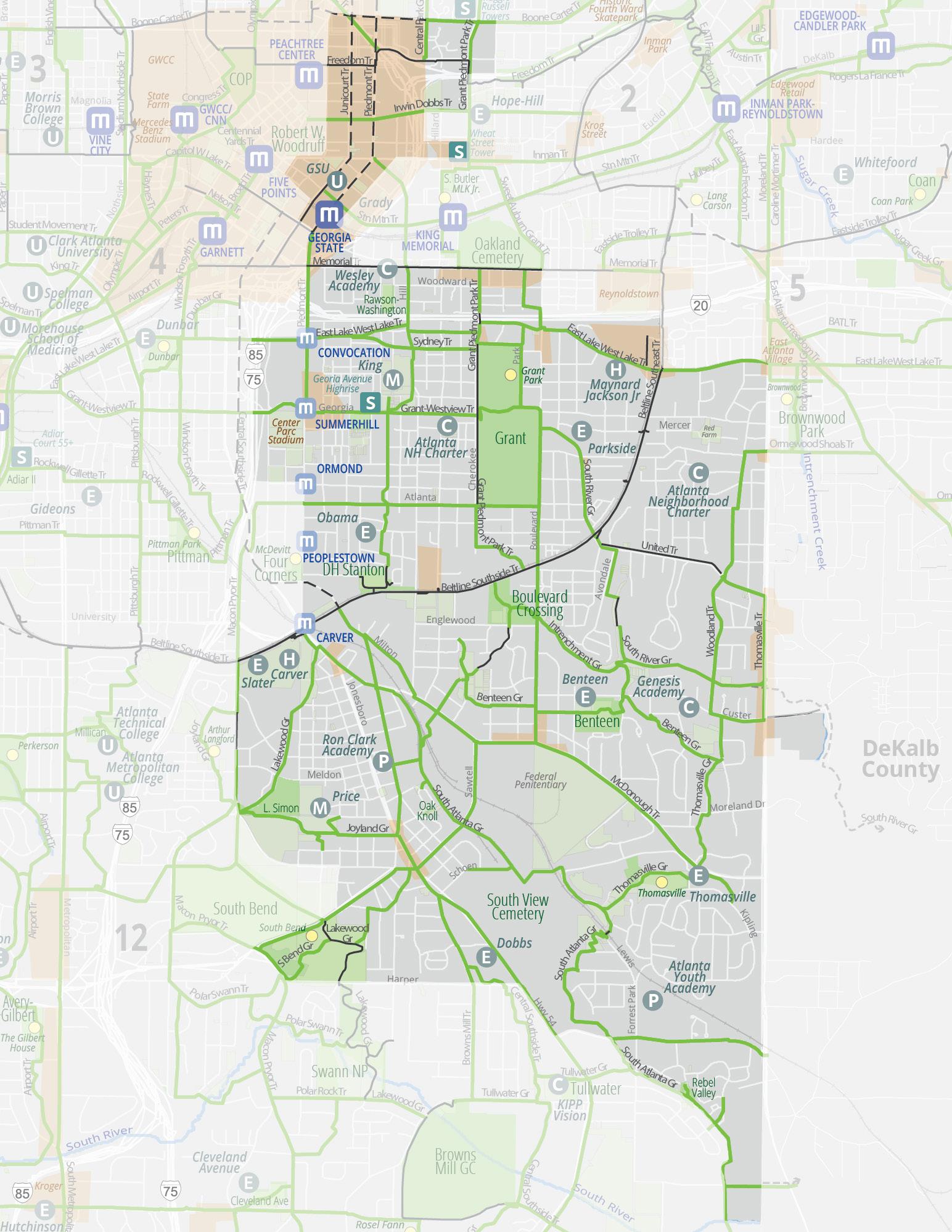
Trails ATL in District 1
Council District 1 is located in Southeast Atlanta and has approximately 42,000 residents – similar to the population of the city of Newnan.
Citywide, Trails ATL includes over 420 miles of new trails. Of those, approximately 70 miles will be in District 1. Below is a summary of trails in District 1:
Existing Trails
7 miles
Funded Trails 2 miles
Proposed Trails
70 miles
Partially Funded Trails 2 miles
New safe and inviting access to natural spaces will be provided by linear park trails including: Benteen Greenway, segments of Central Southside Trail , Chosewood Greenway, Joyland Greenway, Lakewood Greenway, South River Greenway and Thomasville Greenway. Protected and safe on-street facilities include the Grant Piedmont Park Trail, McDonough Trail, the Zoolanta Trail, and others.
Neighborhoods

Council District 1 includes all or parts of Neighborhood Planning Units M, V, W, Y and Z. Trails ATL will provide quality trail access to all neighborhoods in District 1 including:
• Benteen Park
• Boulevard Heights
• Capitol Gateway
• Chosewood Park
• Custer McDonough Guice
• Downtown
• Englewood Manor
Destinations
• Grant Park
• Lakewood Heights
• Leila Valley
• Norwood Manor
• Old Fourth Ward
• Ormewood Park
• Peoplestown
• South Atlanta
• Summerhill
• Sweet Auburn
• Thomasville Heights
• Villages at Carver
• Woodland Hills
The top five destinations identified by Atlantans in Trails ATL surveys are numbered below and accompanied by locations relevant to District 1. The goal of the plan is to create a citywide network of trails accessible within a 10-minute walk (1/3-mile) of all Atlanta homes that, in District 1, will take trail users to:
1. District 1 Commercial Areas
Trails ATL trails provide access to all commercial areas within District 1 including:
• Beacon
• Downtown
• Grant Park
• Lakewood Heights
• South Atlanta
• Summerhill
• Sweet Auburn
2. District 1 Parks
Trails ATL trails provide access to all of the major parks within District 1 including:
• Benteen Park
• Boulevard Crossing Park
• Capitol Gateway Park
• Chosewood Park
3. District 1 Beltline Access
• D H Stanton Park
• Dobbs Plaza
• Grant Park
• Hurt Park
• Phoenix Park (II and III)
• Rawson Washington Park
• South Bend Park
• Thomasville Park
Atlantans love the Beltline, and linking to it is a key goal of Trails ATL. District 1 is bisected by the Beltline’s Southside Trail and Southeast Trail. North of the Beltline, District 1 residents have good access to the Beltline via a relatively coherent street grid. South of the Beltline, however, the street grid is broken apart by railroad lines, streams and large institutions such as the Federal Penitentiary and the State of Georgia facility. The nature of the road network forces travelers of all modes to use a small number of heavily trafficked streets to access the Beltline from South Atlanta. Neighborhoods such as Thomasville Heights, Norwood Park, and Leila Valley have low quality access to the Beltline on roads with broken sidewalks and either nonexistent or unprotected and narrow bike lanes.
4. District 1 MARTA Access
Trails are important extensions of a transit network as they provide good “last mile” connections between final destinations and transit stops. MARTA provides a variety of transit services to Council District 1. The one heavy rail station at Georgia State University will be supported by the forthcoming Summerhill BRT and “NextGen” bus service1 as described below.
• Train Stations: Georgia State Station
• BRT: Summerhill Route with 5 proposed stops and 12-minute frequency
• NextGen Bus lines and frequency:
o 15-minute service: 21, 22 (Memorial Drive)
o 20-minute service: 49
o 30-minute service: 4, 7, 42, and 55
5. District 1 Schools


Schools are a key destination for trails for purposes of transportation, recreation and education. A well-placed trail provides alternatives for students of all ages to get to school without having to be driven. This is especially important in light of the Atlanta Public Schools limiting school bus service to those living more than one-mile from the relevant school. Teachers and parents also note the value to having kids walk or bike to school to burn off youthful energy and support a more focused learning environment. Greenways also offer great opportunities to learn about forested areas and streams and to build confidence in being outdoors. Security cameras and lighting are necessary considerations for trails serving schools. Below is a partial list of schools in District 1.
• Public High Schools: Carver and Maynard Jackson
• Public Middle Schools: King and Price
• Public Elementary Schools: Benteen, DH Stanton, Dobbs, Parkside, and Slater
• Charter Schools: Atlanta Neighborhood, Genesis Academy, and Wesley Academy
• Private Schools: Ron Clark Academy and Atlanta Youth Academy
Council District 1 Extract of Map of MARTA NextGen Bus Network Plan1
Trails ATL in District 1
District 1 Network Expansion
Existing Network
Funded Trails
Proposed Expansion
Other Jurisdiction
Parks Rec Centers
Public Parcel
Commercial Areas
MARTA Station BRT
Senior Living
Trails ATL Spotlight in District 1
Summerhill Trail
The Summerhill Trail will connect District 1 residents in Summerhill and Peoplestown to key destinations including downtown, Georgia State University, Edgewood Curb Market, Wesley Academy, Grant Park commercial areas, King Middle School, Phoenix Park, Cheney Track Stadium, Obama Academy, DH Stanton Park, and the Beltline. The relatively level alignment will allow users of all ages and abilities to enjoy the health and wellness benefits of biking and walking as they get to where they want to go. The alignment will follow Bell Street, Hill Street and Connally Street with short greenway segments in parks and greenspaces. The main challenge will be the need to acquire easements from private owners; alternative alignments are also available.
Lakewood Greenway
The Lakewood Greenway will be a long-planned District 1 trail connecting residents in the Carver Villages and Lakewood Heights to the Beltline. This trail received partial funding in the 2022 TSPLOST and is a priority for completion. The Lakewood Greenway will provide a safe and inviting bike and pedestrian access for students attending Carver High School, Slater Elementary School, and Price Middle School. Integral Group intends to build affordable housing adjacent to the trail alignment. The greenway will also provide a pleasant connection to South Bend Park and the existing shared-use trail in the Swann Nature Preserve leading to Browns Mill Golf Course. The main challenge will be the creation of an inviting trail that satisfies the security needs of the Lakewood Amphitheater.
South River Greenway
The South River Greenway is a trail of regional significance that will eventually link Grant Park to the Monastery of the Holy Spirit in Rockdale County. The short segment in Atlanta will also be locally useful in that it connects neighbors to the Grant Park Recreation Center, the Beltline Southeast Trail, the Trestletree Village housing complex, and the commercial areas on Moreland Avenue. The segment behind the State of Georgia’s facility on United Avenue is truly beautiful and little known to most Atlantans. The main challenges will be the acquisition of easements, parking adjustments on United Avenue, and coordination with the State of Georgia and Georgia Dept of Transportation.


Summerhill Trail - possible alignment near MLK Middle School
Lakewood Greenway - possible alignment in Lucius D. Simon Memorial Park
South River Greenway - possible alignment along Intrenchment Creek and DWM facility
South Atlanta Greenway
The South Atlanta Greenway will be a potentially transformational trail connecting residents from far southeast Atlanta to the Beltline following a stream and an unused rail spur. This greenway will provide a much needed safe and inviting trail network access to residents of Thomasville Heights, Norwood Manor, and Leila Valley. Trails promote healthy and affordable travel alternatives – important considerations in these neighborhoods that have suffered from decades of disinvestment. The rail spur alignment from Thomasville to the Beltline is surrounded by parcels with potential for high-quality, dense development. The main challenge will be the need to acquire the rail spur and easements on large privately owned parcels currently dedicated to trucking.
Existing Conditions along unused Norfolk Southern Rail Spur Location Map


Proposed

Trails ATL in District 2
Council District 2 is located east of Midtown Atlanta and has approximately 40,000 residents – similar to the population of the city of Mableton. Trails ATL is recommending over 420 miles of new trails. Of those, approximately 31 miles will be in District 2. Below is a summary of trails in District 2:
Existing Trails 11 miles
Funded Trails 7 miles
Proposed Trails 31 miles
While highly urbanized, Trails ATL nonetheless sees opportunities in District 2 for new, safe, and inviting access to greenspaces by the Central Park Greenway and segments of the Virginia Trail and the Renaissance Freedom Trail. Protected and safe on-street facilities will be key in District 2 and include the Grant Piedmont Park Trail, an upgrade to the Stn Mtn Trail, the Virginia Freedom Trail, the Midtown Trail, the Highland Trail, and others.
Neighborhoods

Council District 2 includes parts of Neighborhood Planning Units E, F, M and N. Trails ATL will provide quality trail access to all neighborhoods in District 2 including:
• Midtown
• Virginia Highland
• Atkins Park
Destinations
• Poncey-Highland
• Old Fourth Ward
• Inman Park
The top five destinations identified by Atlantans in Trails ATL surveys are numbered below and accompanied by locations relevant to District 2. The goal of the plan is to create a citywide network of trails accessible within a 10-minute walk (1/3-mile) of all Atlanta homes that, in District 2, will take trail users to:
1. District 2 Commercial Areas
Trails ATL trails provide access to all commercial areas within District 2 including:
• Atkins Park
• Beltline Eastside Trail
• Little Five Points
• Midtown
• Poncey Highland
• Virginia Highland
• Inman Park
2. District 2 Parks
Trails ATL trails provide access to all of the major parks within District 2 including:
• Central Park
• Freedom Park
3. District 2 Beltline Access
• John Howell Memorial Park
• Old Fourth Ward Park
• Renaissance Park
• Springvale Park
Atlantans love the Beltline, and linking to it is a key goal of Trails ATL. District 2 is bisected by the Beltline’s Eastside Trail and generally, has good pedestrian access. Bicycles and scooters, however, are typically forced to share the road with vehicles. Trails ATL seeks to remedy this by providing access between key neighborhood nodes – Virginia Highland, Poncey Highland, and Little Five Points – and the Beltline with protected all-ages/all-abilities street trails. Some street trails would upgrade existing bike lanes where others would have new protected infrastructure. Street trail planning is inherently political as the public right of way may be reallocated in the interest of safety and usability for a broader range of residents. Trails ATL seeks to minimize disruption to on-street parking and travel patterns and will further engage neighbors during the design phase to obtain input and feedback on specific trail designs.
4. District 2 MARTA Access
Trails are important extensions of a transit network as they provide good “last mile” connections between final destinations and transit stops. MARTA provides a variety of transit services to Council District 2. The three heavy rail stations will be supported by the forthcoming “NextGen” bus service1 as described below.
• Train Stations: Arts Center, Midtown, Inman Park
• BRT: North Avenue BRT is in the early planning stages
• NextGen Bus lines and frequency:
o 12-minute service: 2
o 15-minute service: 51
o 30-minute service: 7, 11
5. District 2 Schools

Schools are a key destination for trails for purposes of transportation, recreation, and education. A well-placed trail provides alternatives for students of all ages to get to school without having to be driven. This is especially important in light of the Atlanta Public Schools limiting school bus service to those living more than one mile from the relevant school. Teachers and parents also note the value to having kids walk or bike to school to burn off youthful energy and support a more focused learning environment. Greenways also offer great opportunities to learn about nature and to build confidence in being outdoors. Security cameras and lighting are necessary considerations for trails serving schools. Below is a partial list of schools in District 2.
• Public High Schools: Midtown
• Public Middle Schools: Howard
• Public Elementary Schools: Hope Hill and Virginia-Highland are just outside the district
• Charter Schools: Kindezi Old Fourth Ward
Council District 2 Extract of Map of MARTA NextGen Bus Network Plan1
Trails ATL in District 2

Trails ATL Spotlight in District 2
Central Park Greenway
The Central Park Greenway will be a unique opportunity to reclaim 2/3 mile of pavement on the northbound lanes of Central Park Place and convert them to a lushly landscaped greenway and linear park from the Baker Highland Connector up to North Avenue. The existing southbound travel lanes will then be converted to two-way operation. The greenway will tie into forthcoming development at the Civic Center site and other housing projects coming online in the neighborhood over the next few years. While not as critical from a transportation viewpoint, it scores highly from parks, recreation, stormwater management, and urban beautification perspectives. The primary challenge will be funding the design and construction.
Grant Piedmont Park Trail
The Grant Piedmont Park Trail will be an important north-south street trail that will connect two of the city’s signature parks and the King Center through medium to high-density residential neighborhoods. It will provide access to Midtown High School, Howard Middle School, and Hope Hill Elementary School. For much of the proposed alignment, there is roadway capacity for protected facilities. The primary challenge will be the segment between 4th and 8th Streets on Charles Allen, which will require some creativity and careful collaboration with the neighbors to create an all-ages/all-abilities connection. Trail construction can be phased to provide time for the neighborhood to come together around a plan.
Tech Beltline Trail


The Tech Beltline Trail will be a valuable connection between the core of Georgia Tech’s campus, the Midtown commercial and residential districts, Midtown Promenade commercial area, and the Beltline. Today, the Midtown Promenade and Midtown Place shopping areas are barriers to east-west travel forcing bicyclists and pedestrians onto high traffic streets on Ponce de Leon and 10th Street. The Tech Beltline Trail seeks to a connection between the two that would enable students, visitors, and residents from Midtown to access the Beltline on a safe and inviting series of street trails – segments of which are complete on 5th Street. Concerns related to crime, privacy, and parking for residents along the trail alignment should be addressed during project design. Once at the Beltline, the trail would continue eastward as a spur to the Virginia Trail. The primary challenges will be easement acquisition through Midtown Place and designing an all-ages/all-abilities trail on neighborhood streets where parking is at a premium.
Looking south on Central Park Gr from Pine Street, the proposed trail will convert half of the parkway to a greenway and linear park.
Piedmont Park entrance with unprotected “sharrows.”
Virginia Trail
The Virginia Trail will connect the Beltline and Midtown High School to the Virginia Highland commercial area. From the Beltline, a greenway could provide an at-grade connection to Virginia Avenue through the Georgia Power site and the small city park at the corner of Virginia Aveand Ponce De Leon Place. When connected to the Tech-Beltline Trail, users will have safe and inviting access to Midtown Promenade and central Midtown along 6th and 5th Streets. The primary challenge will be the segment between John Howell Park and Highland Avenue, which will require some creativity and careful collaboration with the neighbors. Trail construction can be phased to provide time for the neighborhood to come together around a plan.
Location Map

Proposed
Existing Conditions at Georgia Power Site


Trails ATL in District 3
Council District 3 is located in near-westside Atlanta and has approximately 41,000 residents – similar to the population of the city of Mableton. Trails ATL is recommending over 420 miles of new trails. Of those, approximately 77 miles will be in District 3. Below is a summary of trails in District 3:
Existing Trails
22 miles
Funded Trails 7 miles
Proposed Trails 77 miles
Partially Funded Trails 2 miles
New safe and inviting access to natural spaces will be provided by the Terrell Creek Greenway, segments of the Bowen Greenway, the Evelyn Greenway, the Invictus Greenway, the Mozley Westside Greenway, the Finley Temple Greenway, and the Valley of the Hawks Trail. Protected and safe on-street facilities include the Olympic Trail, the East Lake West Lake Trail, the Boone Carter Trail, the Paper Trail, the Ezra Church Trail, the State Trail, and others. Four of these trails are detailed in the Trails Spotlight section.
Neighborhoods

Council District 3 includes all or parts of Neighborhood Planning Units E, G, J, K and L. Trails ATL will provide quality trail access to all neighborhoods in District 3 including:
• Almond Park
• Atlantic Station
• Bankhead/Westin Heights
• Castleberry Hill
• Center Hill
• Dixie Hills
Destinations
• English Ave
• Georgia Tech
• Grove Park
• Harvel Homes
• Home Park
• Hunter Hills
• Midtown
• Penelope Neighbors
• Vine City
• Washington Park
• West Lake
The top five destinations identified by Atlantans in Trails ATL surveys are numbered below and accompanied by locations relevant to District 3. The goal of the plan is to create a citywide network of trails accessible within a 10-minute walk (1/3-mile) of all Atlanta homes that, in District 3, will take trail users to:
1. District 3 Commercial Areas
Trails ATL trails provide access to all commercial areas within District 3 including:
• Atlantic Station
• Boone and Lowery
• Boone and West Lake
• Castleberry Hill
• Echo Street
• Hollowell and HE Holmes
• Hollowell and Hollywood
• Hollowell and Lowery
• Hollowell and West Lake
• Marietta Artery
• Vine City
2. District 3 Parks
Trails ATL trails provide access to all of the parks within District 3 including:
• Ashby Playlot
• Center Hill Park
• Charles Harper Park
• Coach Rambo Park
• Edwin Place Park
3. District 3 Beltline Access
• Ella Mae Wade Brayboy Park
• Grove Park
• JF Kennedy Park
• June Eloy Mundy Park
• Kathryn Johnston Park
• Lindsey Street Park
• Maddox Park
• Rodney Cook Park
• Washington Park
• Westside Park
Atlantans love the Beltline, and linking to it is a key goal of Trails ATL. District 3 is bisected by the Beltline’s Westside Trail and is home to the Westside Beltline Connector that links the Georgia World Congress Center to the Beltline passing by several medium-density developments in varying stages of completion. While residents east of the Beltline have relatively good access to the Westside Trail, residents to the west have limited points of access. Trails ATL proposes quality east-west access along Boone Blvd and the Valley of the Hawks Trail.
4. District 3 MARTA Access
Trails are important extensions of a transit network as they provide good “last mile” connections between final destinations and transit stops. MARTA provides a variety of transit services to Council District 3. The heavy rail stations at Vine City, Ashby, Bankhead will be supported by the forthcoming “NextGen” bus service1 as described below.
• Train Stations: Vine City, Ashby, Bankhead Station (HE Holmes and West Lake Stations are just outside the district)
• BRT: Donald Lee Hollowell (included in More MARTA programming for post-2040)
• NextGen Bus lines and frequency:
o 12- minute service: 2
o 15-minute service: 12/14, 14/26, 51
o 20-minute service: 1, 2, and 3
o 30-minute service: 11
5. District 3 Schools

Schools are a key destination for trails for purposes of transportation, recreation and education. A wellplaced trail provides alternatives for students to get to school without having to be driven. This is especially important considering the Atlanta Public Schools need to eliminate school bus service for those living less than one mile from the relevant school. Teachers and parents note that kids walking or biking to school burn off youthful energy, which supports a more focused learning environment. Greenways offer great opportunities to learn about natural environments and build confidence in being outdoors. Security cameras and lighting are necessary considerations for trails serving schools. Below is a partial list of schools in District 3.
• University: Georgia Tech
• Public High Schools: Douglass and Kipp Atlanta Collegiate (Washington HS is just outside the district)
• Public Middle and Elementary Schools: Hollis Innovation Academy (John Lewis Invictus sits outside District 3)
• Charter Schools: Kipp Ways, Kipp Woodson Park, and Kipp West Atlanta
• Private School: Berean
Council District 3 Extract of Map of MARTA NextGen Bus Network Plan1
Trails ATL in District 3

District 3 Network Expansion
Existing Network
Funded Trails
Proposed Expansion
Other Jurisdiction
Parks Rec Centers
Public Parcel
Commercial Areas
MARTA Station
Senior Living
High School
Middle School
Trails ATL Spotlight in District 3
Mozley Franklin Park Greenway
The Mozley Franklin Park Greenway will link Mozley Park and Shirley Clarke Franklin Park with a primary north-south greenway and street trail. Franklin Park is a park of regional significance and is anticipated to be home to mountain biking and bicycle/scooter training facilities. Parallel to Holly Street, the Mozley Franklin Park Greenway will pass by DL Stanton Elementary School and Woodson Academy and will go through Grove Park. The West Lake MARTA Station can be reached via a short connection along the Capitol West Lake Trail. The greenway will provide access to these destinations for residents of Grove Park, Hunter Hills, West Lake, and Mozley Park. The main challenge to building the trail will be the acquisition of easements on large privately owned undeveloped parcels.

Mozley Franklin Park Greenway in District 3 will connect the Grove Park neighborhood to Joseph Boone Blvd and the Valley of the Hawks trail corridor.
Silvertree Seniors
Maddox Park
Bankhead MARTA
North Ave
D.L.H Pkwy
Joseph E. Boone Blvd
W Lake
ChappellRd
KIPP Grove Park Rec Center
Proctor Creek Gr
Valleyofthe Hawks Tr
Terrell Creek Greenway
The Terrell Creek Greenway will follow the forgotten waterway known as Terrell Creek linking Douglass High School to the Proctor Creek Greenway. The creek forms the boundary between the Center Hill and Grove Park neighborhoods. The greenway will provide a crucial north-south walking and biking access between Boone Blvd and Hollowell Pkwy and the forthcoming residential and mixed-use developments along Hollywood Road in Almond Park. Today, there is a nearly two-mile “wall” between West Lake Avenue and HE Holmes Drive that prohibits north-south travel by any means, including walking and biking. This barrier keeps residents south of the Baker St/North Avenue line from enjoying the benefits of Center Hill Park and severely limits student access to Douglass High School and Lewis Academy. School and park links are important for neighborhoods listed as “communities of concern” by city planning and transportation. The main challenge to building the trail will be the acquisition of easements on large privately owned undeveloped parcels.
Location Map
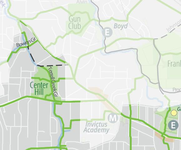
Proposed
Existing Conditions at Center Hill Park


Olympic Trail
The Olympic Trail will be a critical component of Atlanta’s trail network as it will connect many of the city’s iconic destinations, including the Beltline Southside Trail, several MARTA rail stations, Spelman, and Morehouse Colleges, the Mercedes Benz Stadium, State Farm Arena, Centennial Yards, Centennial Olympic Park, the Georgia Aquarium, the Center for Civil and Human Rights, Georgia Tech, Atlantic Station, the Amtrak Station, Piedmont Hospital, the Beltline Northside Trail, and Buckhead. The trail will provide a valuable safe and inviting alternative for travel to busy events and gives tourists access to the places they want to experience. The main challenge to building the trail will be gaining the support of various stakeholders for a protected street trail along the entire length of the trail. This includes gaining the support of CSX Railroad for a tunnel/underpass or repurposing the existing unused rail bridge connecting Atlantic Station to Peachtree Street along Deering Road.
Existing Conditions at Interstate, Railroad and Deering Road Location Map


Proposed

Valley of the Hawks Trail
The Valley of the Hawks Trail will be an important east-west trail connection across the English Avenue, Bankhead, and Grove Park neighborhoods. It is named after a Department of Watershed Management reclamation project near the Westside Beltline and North Avenue. The trail will begin on Georgia Tech’s campus and will include the proposed railroad crossing from the main campus to the Life Sciences campus.
Location Map

Proposed
Existing Conditions under MARTA rail bridge


Valley of the Hawks Trail (cont’d)
It will then follow the street through English Avenue and will become a greenway near Lindsay Park where it will pass by a new naturalized stormwater detention pond. The trail will then tunnel beneath the Westside Beltline before crossing along the southside of the Beltline’s Chappell Road housing development, then intersect with the Mozley Franklin Park Greenway. The main challenge to building the trail will be working with the Beltline on the alignment through the housing development and the acquisition of easements on large privately owned undeveloped parcels.
Existing Conditions looking west on Beltline Westside Trail Location Map


Proposed

Trails ATL in District 4
Council District 4 is located in downtown Atlanta and has approximately 40,000 residents – similar to the population of the city Peachtree Corners. Citywide, Trails ATL is recommending over 420 miles of new trails. Of those, approximately 53 miles will be in District 4. Below is a summary of trails in District 4:
Existing Trails
15 miles
Funded Trails 12 miles
Proposed Trails
53 miles
Although District 4 is heavily urbanized, Trails ATL recommends safe and inviting access to natural spaces via the Rockmart Trail, the West End Trail and the Dunbar Greenway. Protected and safe on-street facilities include the Olympic Trail, the East Lake West Lake Trail, the Grant Westview Trail, the Paper Trail, the Mozley Franklin Park Greenway, the Windsor Forsyth Trail and others. Several of these trails are detailed in the Trails ATL Spotlight section.
Neighborhoods
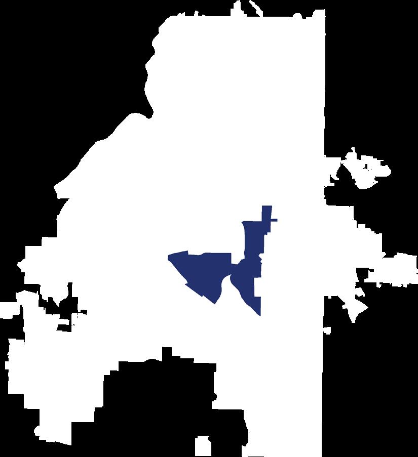
Council District 4 includes all or parts of Neighborhood Planning Units E, M, T and V. Trails ATL will provide quality trail access to all neighborhoods in District 4 including:
• Ashview Heights
• Atlanta University Center
• Castleberry Hill
• Downtown
Destinations
• Harris Chiles
• Just Us
• Midtown
• Mozley Park
• The Villages at Castleberry Hill
• West End
• Westview
The top five destinations identified by Atlantans in Trails ATL surveys are numbered 1 to 5 below and accompanied by locations relevant to District 4. The goal of the plan is to create a citywide network of trails accessible within a 10-minute (1/3-mile) walk of all Atlanta homes that, in District 4, will take trail users to:
1. District 4 Commercial Areas
Trails ATL trails provide access to all commercial areas within District 4 including:
• Beltline Southside Trail
• Castleberry Hill
• Centennial Yards
• Citi Center (Kroger)
• Fairlie Poplar District
• Mechanicsville
• Midtown
• Peachtree Street
• South Downtown
• Underground Atlanta
• West End
• Westview
2. District 4 Parks
Trails ATL trails provide access to most of the parks within District 4 including:
• Centennial Olympic Park
• Cleopas Johnson Park
• Dean Rusk Park
• Enota Park
• Four Corners Park
• Gordon White Park
• Hardy Ivy Park
3. District 4 Beltline Access
• Howell Park
• Mayor’s Park #1
• Mozley Park
• Peachtree Fountains Plaza
• Robert Woodruff Park
• Rosa L. Burney Park
• Rose Circle Park
• Rose Circle Triangle
• Talmadge Plaza
• Walton Spring Park
• West End Park
• Windsor Street Park
Atlantans love the Beltline, and linking to it is a key goal of Trails ATL. District 4 is bordered on the south and west by the Beltline providing access to the entertainment districts along White Street and to the Citi Center Kroger. Although District 4 is cut up by massive transportation infrastructure, the street grid is broken and neighborhood access to the Beltline is challenged. The broken grid, in turn, channels traffic from all travel modes onto a smaller number of oddly aligned streets – many of which are not usable unless you are driving. To break through these barriers, Trails ATL proposes east-west and north-south trails that provide access at six points to the Beltline Southwest and Westside Trails.
4. District 4 MARTA Access
Trails are important extensions of a transit network as they provide good “last mile” connections between final destinations and transit stops. MARTA provides extensive transit services to Council District 4 which enables car free living that could be supplemented by high quality trails. The eight heavy rail stations in the district will be supported by the forthcoming “NextGen” bus service1 as described below.
• Train Stations: North Ave, Civic Center, Peachtree Center, Five Points, Garnett, West End, West Lake and GWCC/CNN Center (Ashby and Vine City Stations are just outside the district).
• BRT: Rapid A Line (Summerhill) – anticipated opening 2026.
• NextGen Bus lines and frequency:
o 10-minute service: 2
o 15-minute service: 10, 51, Streetcar
o 20-minute service: 1, 49, 71
o 30-minute service: 42, 55
o 45-minute service: 81
5. District 4 Schools

Schools are a key destination for trails for purposes of transportation, recreation and education. A well-placed trail provides alternatives for students to get to school without having to be driven. This is especially important considering the Atlanta Public Schools need to eliminate school bus service for those living less than one mile from the relevant school. Teachers and parents note that kids walking or biking to school burn off youthful energy, which supports a more focused learning environment. Greenways offer great opportunities to learn about natural environments and build confidence in being outdoors. Security cameras and lighting are necessary considerations for trails serving schools. Below is a partial list of schools in District 4.
• Universities: Georgia Tech, Georgia State, Morehouse College, Morehouse School of Medicine, Spelman College, Clark Atlanta University, and Morris Brown College
• Public High Schools: Washington
• Public Middle and Elementary Schools: Russell Academy and FL Stanton, Agnes Jones, and Dunbar
• Charter Schools: Centennial Academy and Kipp Strive Academy
Council Disreict 4 Extract of Map of MARTA NextGen Bus Network Plan1
Trails ATL in District 4

District 4 Network Expansion
Existing Network
Funded Trails
Proposed Expansion
Other Jurisdiction
Parks Rec Centers
Public Parcel
Commercial Areas
MARTA Station
Senior Living
High School
Middle School
Trails ATL Spotlight in District 4
King Trail
The King Trail will be an east-west street trail that will intersect with the Olympic Trail and the Pittsburgh Trail near Spelman College. It will run west along Greensferry Ave and Westview Dr through the core of the Atlanta University Center, providing valuable access to students and visitors of Clark Atlanta University, Morehouse College, and BT Harvey (Morehouse) Stadium. After passing by Agnes Jones Elementary School, it will follow a partially completed section up to Ralph D. Abernathy Blvd (“RDA”) where it will provide access to the Westview neighborhood (District 10). Tracking along RDA the King Trail will exit District 4 on MLK near the West Lake MARTA Station as it heads west eventually terminating at Collier Park in Adamsville in west Atlanta. The main challenge for this trail will be coordination with the Atlanta University Center to address security concerns and easement acquisition on pinch points on MLK west of HE Holmes.
Paper Trail
The Paper Trail will be another useful trail for the Atlanta University Center. It will begin at the intersection of the Olympic Trail on Lee and West Whitehall Streets and will end near the Westside Paper development in the Upper Westside on Marietta Street. It will connect West End MARTA, the Mall at West End (and its upcoming redevelopment, “One West End”) and accesses the core of the Atlanta University Center – with Clark Atlanta University, Morris Brown College, as well as Morehouse and Spelman Colleges. The trail will exit District 4 on MLK where it will then pass through the Vine City and English Avenue neighborhoods, providing access via network trails to Franklin Park and the core of the Upper Westside commercial area. The main challenge for this trail will be coordination with the Atlanta University Center to address private gateways.
Grant Westview Trail


The Grant Westview Trail will provide an important east-west connection across District 4. As the name implies, it will begin in Grant Park near Zoo Atlanta and follow Georgia Avenue and RDA Blvd west passing the Summerhill commercial developments, Georgia State sports complexes, and then The Metropolitan development before intersecting the Olympic Trail and Paper Trail near the Mall at West End. The Grant Westview Trail will then proceed along RDA and its extensive commercial zone before exiting the district at the Citi Center Kroger with access to the Beltline Southside Trail. The main challenge for this trail will be to address the number of driveways on RDA and the congested and complicated intersection of RDA and West Whitehall.
Greensferry Ave at Chestnut St: entrances to Spelman and Morehouse Colleges and Clark Atlanta University
Existing Paper Trail alignment in front of West End MARTA Station
Olympic Trail
The Olympic Trail will connect the city’s iconic destinations including the Beltline Southside Trail, four MARTA rail stations, Spelman College, Morehouse College, Midtown, National Center for Civil and Human Rights, the Mercedes Benz Stadium, State Farm Arena, Centennial Yards, Centennial Olympic Park, the Georgia Aquarium, Georgia Tech, the Mall at West End, Atlantic Station, the Amtrak Station, Piedmont Hospital, and the Beltline Northside Trail. The trail will provide a valuable, safe, and inviting alternative for travel to busy events and give tourists access to the places in Atlanta they want to experience. The main challenge to building the trail will be gaining the support of various stakeholders for a protected street trail along the entire length of the trail. This includes gaining the support of CSX Railroad for a tunnel or underpass connecting Atlantic Station to Peachtree Street along Deering Road.
Location Map

Proposed
Existing Conditions at Peters and Walker Streets


Trails ATL in District 5
Council District 5 is located in east Atlanta and has approximately 42,000 residents – similar to the population of the city of Newnan. Trails ATL is recommending over 420 miles of new trails. Of those, approximately 51 miles will be in District 5. Below is a summary of trails in District 5:
Existing Trails 12 miles
Proposed Trails 51 miles
Partially Funded Trails 0.5 miles
Trails ATL calls for safe and inviting access to natural spaces via the Sugar Creek Greenway, segments of the Battle of Atlanta Trail, and the Candler Trail. Protected and safe on-street facilities include the Stn Mtn Trail (alternative spelling for “Stone Mountain”), the Rocky & Drew Trail, the East Lake West Lake Trail, the East Atlanta Freedom Trail, and others. Four of these trails are detailed in the Trails ATL Spotlight section.
Neighborhoods

Council District 5 includes all or parts of Neighborhood Planning Units M, N, O, and W. Trails ATL will provide quality trail access to all neighborhoods in District 5 including:
• Cabbagetown
• Candler Park
• Druid Hills
• East Atlanta
• East Lake
Destinations
• Edgewood
• Grant Park
• Kirkwood
• Lake Claire
• Ormewood Park
• Reynoldstown
• Sweet Auburn
• The Villages at East Lake
The top five destinations identified by Atlantans in Trails ATL surveys are numbered 1 to 5 below and accompanied by locations relevant to District 5. The goal of the plan is to create a citywide network of trails accessible within a 10-minute (1/3-mile) walk of all Atlanta homes that, in District 5, will take trail users to:
1. District 5 Commercial Areas
Trails ATL trails provide access to all commercial areas within District 5 including:
• East Atlanta Village
• Edgewood Retail District
• Glenwood Park
• Kirkwood
• Lake Claire
• Little Five Points
• Madison Yards
• Memorial/Beltline
• Moreland/Wylie
• Pullman Yards
• Sweet Auburn
2. District 5 Parks
Trails ATL trails provide access to most of the parks within District 5 including:
• Bessie Branham Park and Rec Center
• Brightwood Park
• Brownwood Park
• Butler Park and MLK Natatorium
• Cabbagetown Park
• Candler Park
• Coan Park
3. District 5 Beltline Access
• DeKalb Memorial Park
• Freedom Park
• Gilliam Park
• Lake Claire Park
• May Park
• Martin Luther King National Historic Site
• Memorial Drive Greenway
• Olmstead Linear Park
• Springdale Park
• Virgilee Park
• Walker Park
Atlantans love the Beltline, and linking to it is a key goal of Trails ATL. The western section of District 5 is crossed by the Beltline Southeast Trail from Bill Kennedy at Glenwood up to the Krog Tunnel. Protected east-west connections to the Beltline are currently lacking. However, the city has contracted PATH to complete the Eastside Trolley Trail connection to the Beltline providing access at Wylie St and along Flat Shoals Ave and on Fulton Terrace. The East Lake West Lake, Memorial and Inman Trails are all recommended to provide safe and inviting connections to the Beltline from Downtown and points west towards Decatur in the east.
4. District 5 MARTA Access
Trails are important extensions of a transit network as they provide good “last mile” connections between final destinations and transit stops. MARTA provides extensive transit services to Council District 5. This enables car free living for some residents that could be supplemented by high quality LIT infrastructure. The three heavy rail stations in the district will be supported by the forthcoming “NextGen” bus service1 as described below.
• Train Stations: King Memorial, Inman Park/Reynoldstown, Edgewood/Candler Park (East Lake is just outside District 5).
• BRT: none.
• NextGen Bus lines and frequency:
o 10-minute service: 2
o 15-minute service: 51, 21/22
o 20-minute service: 4, 7, 32/74
o 30-minute service: 21, 22
o 45-minute service: 32, 34, 74
5. District 5 Schools

Schools are a key destination for trails for purposes of transportation, recreation and education. A wellplaced trail provides alternatives for students to get to school without having to be driven. This is especially important considering the Atlanta Public Schools need to eliminate school bus service for those living less than one mile from the relevant school. Teachers and parents also note that kids walking or biking to school burn off youthful energy, which supports a more focused learning environment. Greenways offer great opportunities to learn about natural environments and build confidence in being outdoors. Security cameras and lighting are necessary considerations for trails serving schools. Below is a partial list of schools in District 5.
• Public High Schools: Maynard Jackson (just outside District 5)
• Public Middle Schools: Howard (just outside District 5)
• Public Elementary Schools: Burgess-Peterson Academy, Mary Lin, Springdale Park, Toomer, and Hope Hill
• Charter Schools: Kindezi Old 4th Ward and Drew
• Private Schools: The Paideia School
Council District 5 Extract of Map of MARTA NextGen Bus Network Plan1
Trails ATL in District 5

Trails ATL Spotlight in District 5
Stn Mtn Trail
The Stn Mtn Trail (alternative spelling of Stone Mountain) is part of the primary network and is also a regionally significant trail as it will connect downtown Atlanta to the City of Stone Mountain, passing through Decatur and Tucker along the way. This trail was one of the first trails built in Atlanta by the PATH Foundation in advance of the 1996 Olympic Games. While mostly complete, the sections in Atlanta are disjointed and share alignments with the Freedom Trail. To clear up the confusion, the Freedom Trail will follow the alignment through Freedom Park down to Centennial Olympic Park, while the Stn Mtn Trail will use a protected sidepath alignment along DeKalb Avenue and Decatur Street to downtown. The main challenge for building this trail will be the need to address motorist turning movements during peak periods between Krog and Hurt, Elmira and Oakdale and Mell and Clifton. While a mild inconvenience for motorists, the gain in safety will be significant and will greatly enhance cross-town bikeability.
East Atlanta Freedom Trail


The East Atlanta Freedom Trail will connect East Atlanta to Freedom Park and cross a critical segment of Moreland Avenue over I-20 – currently a painful pinch point that prohibits most residents from walking, using a wheelchair, or biking in what are otherwise very walkable and bikeable neighborhoods. This primary network trail starts at the city limit in Gresham Park (City staff should collaborate with DeKalb County on an extension to the Walmart) and will follow Flat Shoals Ave through East Atlanta. The main challenges will be traffic engineering and parking. In the Village, care will need to be taken to balance the needs for parking and a safe and inviting access to the commercial district. The city should consider building a small parking structure to free up some on-street parking on one side of the street that may be then be repurposed into a two-way buffered bike lane. On residential streets with parking on both sides, parking may be limited to one side of the street, then combining the parking lane and the sidewalk into a landscaped sidepath providing beautification and safety benefits.
East Lake West Lake Trail
The East Lake West Lake Trail, as its name implies, will be a crosstown trail connecting the East Lake and West Lake communities from Candler Road in the east to Boone Blvd in the west. It will be part of the primary trail network and gives access to eight schools (including two high schools), East Atlanta, Grant Park, Georgia State, the Mall at West End, Morehouse School of Medicine, and Coach Rambo Park. The East Lake West Lake Trail is envisioned primarily as a protected sidepath. The main challenges to building the trail will be easement acquisition and traffic engineering. As with all street trails, the goal is to have very limited impact on motorists while still providing a safe and inviting all-ages, all-abilities network.
Stn Mtn Trail will provide continuous protected alignment from Downtown Atlanta to Downtown Decatur and beyond to Stone Mountain.
Flat Shoals Ave in East Atlanta Village
Sugar Creek Greenway
The Sugar Creek Greenway will be part of the primary trail network and will connect Coan Park to DeKalb Memorial Park via Sugar Creek, an abused urban stream that is largely unnoticed by nearby residents. The greenway will represent a canvas providing an opportunity for the community to come together for invasive species removal, stream daylighting, and historic tree preservation (“Alba” and her sisters are a collection of historic oaks born in the 1850s). It also will provide A safe and inviting access threading through fairly intense automotive traffic in areas, that today, do not feel very walkable. The Battle of Atlanta Trail, the Clifton Arizona Trail, the Eastside Trolley Trail, and the East Lake West Lake Trail will all intersect the greenway. The main challenges to building the greenway will be easement acquisition and engineering for the tunnels envisioned to pass beneath Maynard Terrace and Clifton Street.
Location Map

Proposed
Existing Conditions at Clifton Street


Trails ATL in District 6
Council District 6 is located in east Atlanta and has approximately 44,000 residents – similar to the population of the city of Newnan. Trails ATL is recommending over 420 miles of new trails. Of those, approximately 34 miles will be in District 6. Below is a summary of trails in District 6:
Existing Trails 7 miles
Funded Trails 9 miles
Proposed Trails 34 miles
In spite of it being in the center of a major American city, Trails ATL sees opportunities for safe and inviting access to natural spaces in District 6 via the South Peachtree Greenway and segments of the Peachtree Garden Greenway. Protected and safe on-street facilities include the Lindbergh Battle Trail, Piedmont Trail, Cheshire Chatt Trail, Lenox Trail, Highland Trail, and others. Several of these trails are detailed in the Trails ATL Spotlight section.
Neighborhoods

Council District 6 includes parts of Neighborhood Planning Units B, E and F. Trails ATL will provide quality trail access to all neighborhoods in District 6 including:
• Ansley Park
• Colonial Homes
• Edmund Park
• Emory
Destinations
• Garden Hills
• Lindridge/Martin Manor
• Morningside/Lenox Park
• Peachtree Heights East
• Peachtree Hills
• Piedmont Heights
• Sherwood Forest
• Virginia Highland
The top five destinations identified by Atlantans in Trails ATL surveys are numbered below and accompanied by locations relevant to District 6. The goal of the plan is to create a citywide network of trails accessible within a 10-minute (1/3-mile) walk of all Atlanta homes that, in District 6, will take trail users to:
1. District 6 Commercial Areas
Trails ATL trails provide access to all commercial areas within District 6 including:
• Amsterdam Walk
• Ansley Mall
• Ansley Plaza
• Armand Road Park
• Armour Yard
• Cheshire Bridge
• Herbert Taylor Park
• Lindbergh (just outside District 6)
• Peachtree Midtown
• Peachtree Heights
• Virginia Highland
2. District 6 Parks
Trails ATL trails provide access to most of the parks within District 6 including:
• Alexander Park
• Ansley Park
• Bagley Park
• Garden Hills Park
3. District 6 Beltline Access
• Lenox/Wildwood Park
• Morningside Nature Preserve
• Piedmont Park
• Sidney Marcus Park
• Sunnybrook Park
• Winn Park
• Yonah Park
Atlantans love the Beltline, and linking to it is a key goal of Trails ATL. District 6 is fortunate to have the Beltline as a central feature. However, as in other parts of the city, the street grid in District 6 does not always provide safe and inviting access. While there are streets leading to Beltline entry points, such as Montgomery Ferry or Piedmont Avenue, they are not, suitable for all-ages/all-abilities travel on. In other locations such as at the end of Wimbledon Street near Peachtree Hills Recreation Center, or from Brookwood Hills, there is proximity, but no access. This means nearby residents have to travel on busy, sometimes dangerous roads to get to the Beltline. To resolve this lack of access, Trails ATL proposes additional Beltline connections via the Peachtree Garden Greenway, the Wimbledon Trail, the Cheshire Chatt Trail, the Piedmont Trail, the Emory Trail, and the Virginia Trail.
4. District 6 MARTA Access
Trails are important extensions of a transit network as they provide good “last mile” connections between final destinations and transit stops. MARTA provides bus service to District 6 expected to be reshaped by the forthcoming “NextGen” bus service1 as described below.
• Train Stations: none (but Lindbergh and Arts Center Station are just outside the district)
• BRT: none
• NextGen Bus lines and frequency:
o 15-minute service: 15
o 20-minute service: 23
o 30-minute service: 7 and 11
5. District 6 Schools

Schools are a key destination for trails for purposes of transportation, recreation and education. A wellplaced trail provides alternatives for students to get to school without having to be driven. This is especially important considering the Atlanta Public Schools need to eliminate school bus service for those living less than one mile from the relevant school. Teachers and parents also note that kids walking or biking to school burn off youthful energy, which supports a more focused learning environment. Greenways offer great opportunities to learn about natural environments and build confidence in being outdoors. Security cameras and lighting are necessary considerations for trails serving schools. Below is a partial list of schools in District 6.
• Public High Schools: none (Midtown HS is just outside District 6)
• Public Middle Schools: none
• Public Elementary Schools: Garden Hills, Virginia Highland, and Morningside (E. Rivers is just outside District 6)
• Charter School: Hillside
Council District 6 Extract of Map of MARTA NextGen Bus Network Plan1
Trails ATL in District 6

Trails ATL Spotlight in District 6
Emory Trail
The Emory Trail will be a critical east-west street trail on the primary network. It will begin at the Piedmont Trail at the Atlanta Botanical Gardens and will skirt the northern edge of Piedmont Park providing access to park amenities, and will cross Beltline Northeast Trail. The all-ages, all-abilities trail design continues east through Morningside along Cumberland Road – a relatively level alignment in an otherwise very hilly neighborhood. It will intersect with the Highland Trail, the Lenox Trail, and the South Peachtree Greenway repurposing existing bike lanes on Johnson Road into an all-ages, all-abilities design to the city limit at Briarcliff Rd. Just outside the city limit, at Sage Hill Shopping Center, the trail will track the backside of the shopping center down the hill to re-enter Atlanta at Old Briarcliff Way. The trail will cross over to Clifton Road where it tracks the southside of the street as a sidepath up the hill where it will join an existing PATH trail at Houston Mill Rd. The main challenges to building the trail will be acquisition of easements and community buy-in for an all-ages, all-abilities trail design.
Peachtree Garden Greenway


The Peachtree Garden Greenway will be an important primary network Beltline connection trail for the neighborhoods north of Peachtree Creek –Peachtree Heights, Peachtree Hills, and Garden Hills and Buckhead. It will begin at the Beltline and crosses north using an existing trails easement to reach Peachtree Hills Recreation Center. It will then use neighborhood streets in an all-ages, all-abilities design to reach Alexander Park where it will enter from Alexander Drive and will exit the park to the north providing access to Garden Hills Rec Center. It will then scoot along Sunnybrook Park and use the street network via Hills Drive to entire Bagley Park from the southeast. Thinking also of the Bagley Trail coming from the west, a goal of the trail network in this area is to provide alternative travel for the popular Buckhead Baseball league events in Bagley Park that generate significant traffic. The main challenges for building this trail will be addressing the Beltline intersection and community buy-in for a safe and inviting all-ages, all-abilities trail design.
Piedmont Trail
The Piedmont Trail will be a vital north-south trail in the Trails ATL primary network. Stretching from Summerhill in the south to Lindbergh in the north, the street trail will leverage previously planned infrastructure in downtown and midtown. The plan includes two-way operation on Capitol Avenue and Piedmont Ave. The Piedmont Trail will connect many destinations including Georgia State MARTA, the Civic Center redevelopment, Piedmont Park, Ansley commercial area, Cheshire Bridge commercial area, and Lindbergh MARTA Station. The design of the all-ages, all-abilities trail should balance the creation of a safe and inviting trail with the needs of motorists. Further lane reductions beyond what is already planned should be limited to areas where the lane reduction will reduce speeds and not greatly impact motorist travel times. The main challenge to building the trail will be easement acquisition along some of the right of way pinch points.
Emory Trail along Clifton Rd with CDC entrance to the right, facing south
Greenway corridor east of Peachtree Hills Place Retirement Community
South Peachtree Greenway
The South Peachtree Greenway will follow the South Fork of Peachtree Creek – a beautiful natural resource that has been heavily impacted by urban development. The biggest threats are invasive species and streambank erosion from stormwater. An ecologically sensitive trail plan must address both of these issues. The South Fork Conservancy was formed in 2008 in this spirit, both to protect the creek and to oversee creation of a network of trails. Some shorter segments have been completed, while others have been designed to a certain level. The main challenge to building the trail will be community buy-in.
Location Map

Proposed
Existing Conditions under Houston Mill Road


Trails ATL in District 7
Council District 7 is located in northeastern Atlanta and has approximately 44,000 residents – similar to the population of the city of Newnan. Trails ATL is recommending over 420 miles of new trails. Of those, approximately 20 miles will be in District 7. Below is a summary of trails in District 7:
Existing Trails 6 miles
Funded Trails 5 miles
Proposed Trails 20 miles
Partially Funded Trails 1 miles
Trails ATL recommends safe and inviting access to natural spaces that would be provided by the Blue Heron Greenway and the regionally significant Peachtree Creek Greenway. Protected and safe on-street facilities include the Armour Yard Trail, Chastain 400 Trail, Dunwoody Trail, Lenox Trail, Pinetree Trail, Shady Valley Trail, Wieuca Trail, segments of the Lindbergh Battle, Piedmont Trails, and additional segments of PATH 400. Several of the trails included in the master plan are detailed in the Trails ATL Spotlight section.
Neighborhoods

Council District 7 includes all or parts of Neighborhood Planning Unit B. Trails ATL will provide quality trail access to all neighborhoods in District 7 including:
• Brookhaven
• Buckhead Forest
• Buckhead Heights
• Buckhead Village
Destinations
• Lenox
• Lindbergh/Morosgo
• North Buckhead
• Peachtree Park
• Pine Hills
• Ridgedale Heights
The top five destinations identified by Atlantans in Trails ATL surveys are numbered below and accompanied by locations relevant to District 7. The goal of the plan is to create a citywide network of trails accessible within a 10-minute (1/3-mile) walk of all Atlanta homes that, in District 7, will take trail users to:
1. District 7 Commercial Areas
Trails ATL trails provide access to most of the commercial areas within District 7, including:
• Armour Yard
• Buckhead Landing
• Buckhead Village
• Canterbury Road
• Lenox Mall
• Lenox Marketplace
• Lenox Village
• Lindbergh
• Phipps Plaza
• Tower Place
• Tuxedo Festival
2. District 7 Parks
Trails ATL trails provide access to most of the parks within District 7 including:
• Blue Heron Nature Preserve
• Indian Creek Park
• Little Nancy Creek Park
3. District 7 Beltline Access
• Loridans Park
• Mountain Way Commons
• Old Ivy Road Park
• Shady Valley Park
Atlantans love the Beltline, and linking to it is a key goal of Trails ATL. The Beltline Northeast Trail is just outside of District 7. The Peachtree Creek Greenway is the primary entry point to the Beltline from District 7 providing access east to the cities of Brookhaven and Chamblee. PATH 400 meets the Peachtree Creek Greenway a short distance from the Beltline and provides regionally significant connections to Buckhead and beyond to Sandy Springs and Dunwoody. Another entry point, more locally useful, is proposed via the Armour Yard Trail using Plasters and Mayson Streets and an easement from MARTA to get to Piedmont Rd and the Piedmont Trail.
4. District 7 MARTA Access
Trails are important extensions of a transit network as they provide good “last mile” connections between final destinations and transit stops. MARTA provides bus and train service to Council District 7. There are three heavy rail stations and five bus lines in the district. A large area in the northeastern part of the district east of Roswell and north of Lenox has no transit service. The forthcoming “NextGen” bus service1 in District 7 is described below.
• Train Stations: Lindbergh, Buckhead and Lenox Stations
• BRT: none
• NextGen Bus lines and frequency:
o 15-minute service: 39
o 20-minute service: 5 and 23
o 30-minute service: 17
5. District 7 Schools

Schools are a key destination for trails for purposes of transportation, recreation and education. A well-placed trail provides alternatives for students to get to school without having to be driven. Teachers and parents note that kids walking or biking to school burn off youthful energy, which supports a more focused learning environment. Greenways offer great opportunities to learn about natural environments and build confidence in being outdoors. Security cameras and lighting are necessary considerations for trails serving schools. Below is a partial list of schools in District 7, many of which are served by Trails ATL in this plan.
• Public Middle School: Sarah Smith
• Public Elementary School: Sarah Smith
Council District 7 Extract of Map of MARTA NextGen Bus Network Plan1
Trails ATL in District 7

Trails ATL Spotlight in District 7
Chastain 400 Trail
The Chastain 400 Trail will be a crucial east-west link across the center of District 7 providing access to PATH 400, Sarah Smith Elementary School, the Tuxedo Park commercial area, and Chastain Park. It will be one of three Signature Streets of Buckhead (along with Dunwoody Trail and Wieuca Trail described below). The vision is for a landscape protected sidepath that repurposes an existing one-way bike lane for two-way safe and inviting sidewalk level travel. Outside the district, the trail continues along Powers Ferry Rd to Chastain Park. The main challenge for this trail would be community buy in and possible minor easement acquisition.
Wieuca Trail
The Wieuca Trail will provide an important primary network connection between Phipps Plaza and Chastain Park with midpoint access to PATH 400. It ill also gives students and families attending Sarah Smith Intermediate School an alternative way to and from the school. This street trail has long been discussed by neighborhood leaders in the North Buckhead Civic Association in their “Signature Streets of Buckhead” planning effort. A landscape-protected sidepath along this route will repurpose the unprotected bike lanes and complete the alignment. The main challenge for this trail will be community buy in and possibly some minor easement acquisition near Roswell Road depending on the final design.
Dunwoody Trail
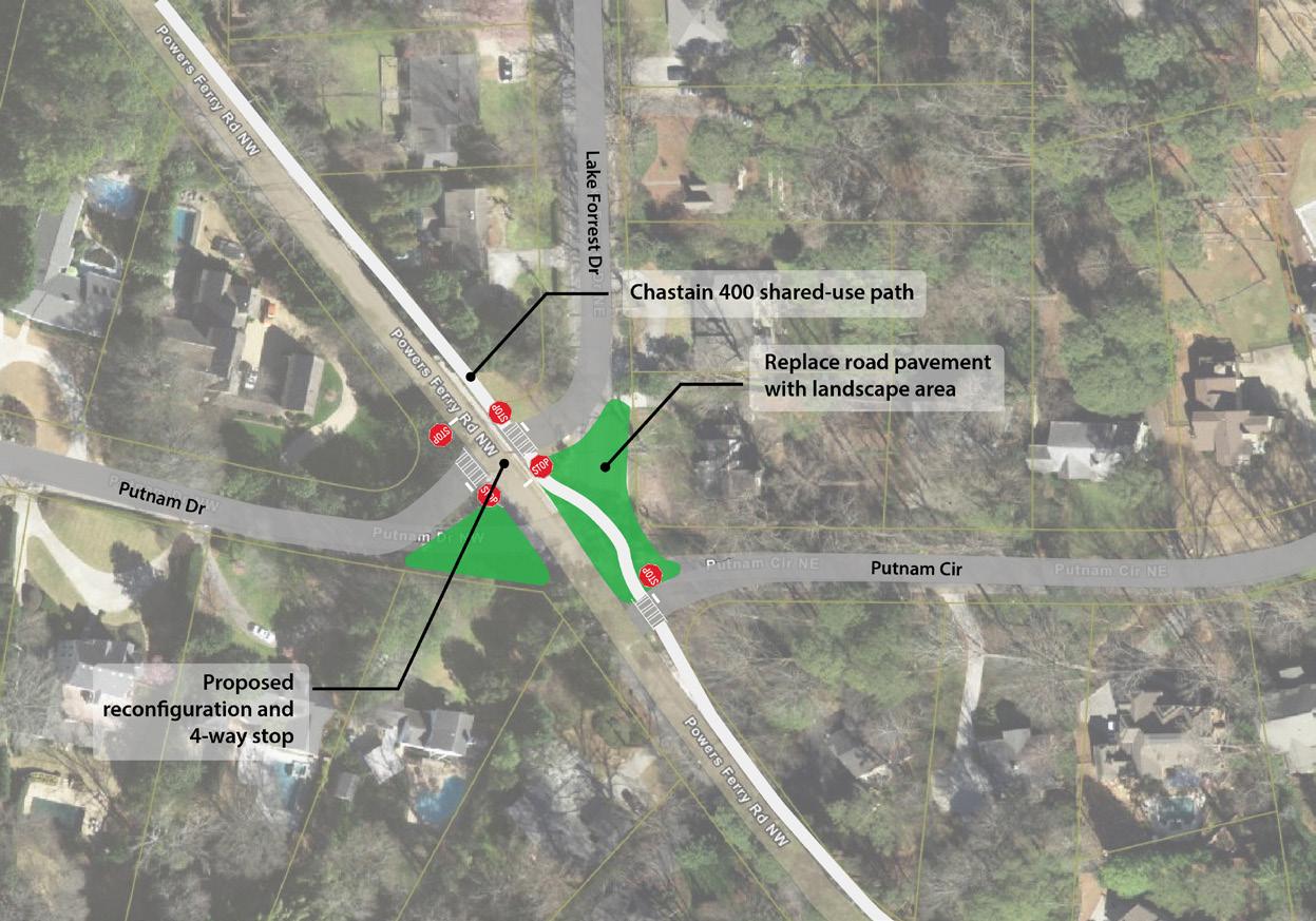

The Dunwoody Trail will provide vital alternative mode travel to a large swath of northeast Atlanta with no access to either transit or safe and inviting trail infrastructure. This street trail has long been discussed by neighborhood leaders in the North Buckhead Civic Association in their “Signature Streets of Buckhead” planning effort. A landscape-protected sidepath along this route will repurpose some unprotected bike lanes and slightly narrow travel lanes to provide a safe and inviting place to walk and bicycle. The main challenge for this trail will be community buy in.
Lenox Trail
The Lenox Trail will be a street trail on the Trails ATL primary network. It will connect the core of the Buckhead commercial district to Cheshire Bridge with trail links to Emory University. Along the way, it will provide walking, wheelchair, and bicycling access to many multi-family and townhome developments and to Indian Creek Park – one of just a few public greenspaces in the district. A spur trail provides access to the Pine Hills single family neighborhood and Shady Valley Park. The main challenge for this trail will be confirming a design that is both safe and inviting as it fronts a very busy road.
Trails ATL recommends a detailed study for the five-way intersection including Powers Ferry Rd and Lake Forrest Dr to enable safe crossing and improved stormwater management.
Looking west on the future Wieuca Trail alignment close to PATH 400 Trail.
Trails ATL in District 8
Council District 8 is located in northwestern Atlanta and has approximately 40,000 residents – similar to the population of the city of Peachtree Corners. Trails ATL is recommending over 420 miles of new trails. Of those, approximately 15 miles will be in District 8. Below is a summary of trails in District 8:
Existing Trails 9 miles
Funded Trails 3 miles
Proposed Trails 15 miles
Trails ATL recommends safe and inviting access to natural spaces that would be provided by the Blue Heron Greenway and the Whitewater Greenway. Protected and safe on-street facilities include the North Atlanta Trail and segments of the Olympic Trail, the Wieuca Trail, and the Chastain 400 Trail. Due to the ongoing evaluation of the transportation network in Buckhead, the identified trail network has fewer alignments than the rest of the city. This is not intended to imply that there will be no other street trails in Buckhead, but rather that the planning for street trails must proceed in collaboration with the overall transportation analysis that the neighborhood is currently conducting. Four of the trails included in the master plan are detailed in the Trails ATL Spotlight section.
Neighborhoods

Council District 8 includes all or parts of Neighborhood Planning Units A, B, C and E. Trails ATL will provide quality trail access to several neighborhoods in District 8 including:
• East Chastain
• Mt. Paran/Northside
• Paces
Destinations
• Peachtree Battle Alliance
• West Paces Ferry/Northside
• Whitewater Creek
The top five destinations identified by Atlantans in Trails ATL surveys are numbered below and accompanied by locations relevant to District 8. The goal of the plan is to create a citywide network of trails accessible within a 10-minute (1/3-mile) walk of all Atlanta homes that, in District 8, will take trail users to:
1. District 8 Commercial Areas
Trails ATL trails provide access to all commercial areas within District 8.
• Bennett Street
• Peachtree Square
• Peachtree/Collier (near Piedmont Hospital)
• West Paces
2. District 8 Parks
Trails ATL trails provide access to all of the parks within District 8 including:
• Atlanta Memorial Park
• Blue Heron Nature Preserve
• Chastain Park
3. District 8 Beltline Access
• Fort Peachtree Landings
• Haynes Manor Park
• Howard Park
• Tanyard Creek Park
• Tanyard Creek Urban Forest
Atlantans love the Beltline, and linking to it is a key goal of Trails ATL. The Beltline Northside Trail crosses the southern tip of District 8 via an I-75 underpass, Tanyard Creek, Tanyard Park, Atlanta Memorial Park, and Bennett Street. There are several access points, but limited parking availability. City staff should work with the neighborhoods to identify safe and inviting trail alignments from deeper within the district that provide access to the Beltline without having to drive.
4. District 8 MARTA Access
Trails are important extensions of a transit network as they provide good “last mile” connections between final destinations and transit stops. MARTA provides extremely limited service to Council District 8. There are no heavy rail stations in the district and bus service is limited to three lines – two of which are on the eastern border of the district. The forthcoming “NextGen” bus service1 in District 8 is described below.
• Train Stations: none
• BRT: none
• NextGen Bus lines and frequency:
o 10-minute service: none
o 20-minute service: 23 and 5 (along Peachtree and Roswell Roads)
o 30-minute service: 12
o 45-minute service: none
5. District 8 Schools

Schools are a key destination for trails for purposes of transportation, recreation and education. A wellplaced trail provides alternatives for students to get to school without having to be driven. Given the very suburban nature of District 8, most children are driven to school by adults. A safe network of trails would reduce some of this burden and if combined with shuttle service could provide congestion reduction on key corridors. Teachers and parents note that kids walking or biking to school burn off youthful energy, which supports a more focused learning environment. Greenways offer great opportunities to learn about natural environments and build confidence in being outdoors. Security cameras and lighting are necessary considerations for trails serving schools. Below is a partial list of schools in District 8, many of which are served by Trails ATL in this plan. It is hoped that future planning will provide high quality trail access to all schools in the district.
• Public High Schools: North Atlanta
• Public Middle Schools: Sutton
• Public Elementary Schools: Morris Brandon, Jackson, and E Rivers
• Charter Schools: Atlanta Classical Academy
• Private Schools: DaVinci, Galloway School, Lovett School, Pace Academy, Trinity School, and Westminster Schools
Council District 8 Extract of Map of MARTA NextGen Bus Network Plan1
Trails ATL in District 8

Trails ATL Spotlight in District 8
North Atlanta Trail
The North Atlanta Trail will be a regionally significant trail that will provides access to the Beltline and beyond to the center of Atlanta from Cobb County’s Cumberland District along US-41, a GDOT facility. A protected sidepath is envisioned along this route that will lead trail users to the Buckhead street network and potential future neighborhood serving pathways. Students and faculty from schools, including North Atlanta High School, Lovett School, Sutton Middle School, Atlanta Classical Academy, and Atlanta Speech School, could benefit from improved access. The proposed trail will connect to the existing North Atlanta Trail that runs along the west side of Bobby Jones Golf Course and into Atlanta Memorial Park and the Beltline. The main challenge to building this trail will be the coordination with GDOT to create a safe and inviting environment on what is a heavily congested arterial for much of its length.
Whitewater Greenway

The Whitewater Greenway will be a wonderful opportunity to create an accessible trail along the Chattahoochee River from Paces Ferry Road up to Whitewater Creek and the East Palisades Trailhead. The trail will traverse the riverfront at Lovett School and provide viewing platforms for students and visitors. The greenway will then continue across Northside Drive and into a greenspace currently partially served by trails from the National Recreation Area. The main challenge for this trail will be easement acquisition from the school, the developers and coordination with the National Recreation Area.

The Wieuca Trail will provide an important connection between the commercial area of Buckhead (Phipps Plaza area) and Chastain Park with access to PATH 400. This street trail has long been discussed by neighborhood leaders in the North Buckhead Civic Association in their “Signature Streets of Buckhead” planning effort. A landscape-protected sidepath along this route will repurpose the unprotected bike lanes and complete the alignment from Phipps Plaza to Chastain Park. The main challenge for this trail will be community buy in and possibly some minor easement acquisition depending on the final design.
North Atlanta Trail may connect the Beltline to Chattahoochee River along Northside Pkwy. Photo shown at potential bridge location over Nancy Creek along Beechwood Drive.
The Whitewater Greenway alignment along the Chattahoochee River from East Palisades Trailhead to the Lovett School.
Wieuca Trail
Blue Heron Greenway
The Blue Heron Greenway will be an east-west trail tracking a sewer line along Nancy Creek between Blue Heron Nature Preserve and Chastain Park. It will be a beautiful addition to the neighborhood and will allow residents and visitors to enjoy both locations without having to drive. The nature preserve has nature trails and wetlands that are loved by the community, but a very small parking lot that quickly fills up on pleasant days. Future connections into the southern area of the nature preserve should be coordinated with the neighbors and the nature preserve’s advisory board. In Chastain Park, the trail will enter what park developers are calling “The Palisades,” a proposed landscaped hillside with passive lawns and a creek overlook. The main challenge for this trail will be easement acquisition and navigation of EPA Consent Decree parcel requirements.
Existing Conditions at Nancy
Location Map
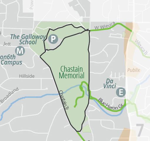
Proposed
Creek west of Roswell Road


Trails ATL in District 9
Council District 9 is located in west Atlanta and has approximately 42,000 residents – similar to the population of the city of Newnan. Trails ATL is recommending over 420 miles of new trails. Of those, approximately 69 miles will be in District 9. Below is a summary of trails in District 9:
Existing Trails 15 miles
Funded Trails 8 miles
Proposed Trails 69 miles
Partially Funded Trails 1 miles
Trails ATL calls for safe and inviting access to natural spaces via the Terrell Creek Greenway, Bowen Greenway, Riverlands Greenway, AD Williams Greenway, and extensions to the Woodall Greenway and Proctor Creek Greenway. Protected and safe on-street facilities include the Cheshire Chatt Trail (from Cheshire Bridge Road to Chattahoochee River), Piedmont Westside Park Trail, 17th Trail, Waterworks Trail, and others. Several of these trails are detailed in the Trails ATL Spotlight section.
Neighborhoods

Council District 9 includes all or parts of Neighborhood Planning Units C, D, E and J. Trails ATL will provide quality trail access to all neighborhoods in District 9 including:
• Almond Park
• Berkeley Park
• Blandtown
• Bolton
• Carey Park
• Carver Hills
Destinations
• Cross Creek
• Fernleaf
• Grove Park
• Hanover West
• Hills Park
• Home Park
• Loring Heights
• Ridgewood Heights
• Rockdale
• Underwood Hills
• West Highlands
• Westover Plantation
The top five destinations identified by Atlantans in Trails ATL surveys are numbered below and accompanied by locations relevant to District 9. The goal of the plan is to create a citywide network of trails accessible within a 10-minute (1/3-mile) walk of all Atlanta homes that, in District 9, will take trail users to:
1. District 9 Commercial Areas
Trails ATL trails provide access to all commercial areas within District 9 including:
• Atlantic Station
• Brookview Heights (Hollowell/Jackson)
• Chattahoochee Food Works
• Collier and Defoors Ferry
• District at Howell Mill
• Moores Mill Center
• Riverside
• Upper Westside
• Westside Village
2. District 9 Parks
Trails ATL trails provide access to most of the parks within District 9 including:
• AD Williams Park
• Bolton Road
• Chattahoochee Park
• Chattahoochee Brick Memorial Park
• Edwin Place Park
• Grove Park
3. District 9 Beltline Access
• Gun Club Park
• Lillian Cooper Shepherd Park
• Lower Paul Park
• Mantissa Road
• Millennium Gate
• Riverside Park
• Rockdale Park
• Shirley Clarke Franklin Park
• Spink-Collins Park
• Underwood Hills Park
• Waterworks Atlanta
• Watkins Park
• Whetstone Creek Park
• Whittier Mills Park
Atlantans love the Beltline, and linking to it is a key goal of Trails ATL. The easternmost section of District 9 is crossed by the Beltline’s Northwest Trail from West Marietta St to I-75. District 9 is heavily impacted by freight rail infrastructure which cuts the district in half and makes travel in any mode challenging but especially for people walking and biking. Further access barriers include the City of Atlanta’s Hemphill Waterworks, Crestlawn Cemetery, and even Franklin Park.
Existing and near future connections to the Beltline are limited to the Silver Comet Connector Trail at Ellsworth Industrial. Trails ATL calls for connections to the Beltline from the core of Franklin Park – the “Westside Ride” trail, the 14th Huff Trail cutting across the Upper Westside commercial area with access to Midtown; the Cheshire Chatt Trail, linking Underwood Hills and Loring Heights to the Beltline and beyond; the Waterworks Trail along Howell Mill Rd; and the Loring Heights Greenway, envisioned to connect Atlantic Station to the Beltline through a rail crossing along Deering Road.
4. District 9 MARTA Access
Trails are important extensions of a transit network as they provide good “last mile” connections between final destinations and transit stops. MARTA provides bus service to District 9 expected to be reshaped by the forthcoming “NextGen” bus service1 as described below.
• Train Stations: none
• BRT: none
• On Demand Zones: Proctor Creek, West Atlanta
• NextGen Bus lines and frequency:
o 20-minute service: 1, 2
o 30-minute service: 11, 12, 14, 26
o 60-minute service: 26a, 26b
5. District 9 Schools

Schools are a key destination for trails for purposes of transportation, recreation and education. A well-placed trail provides alternatives for students to get to school without having to be driven. This is especially important considering the Atlanta Public Schools need to eliminate school bus service for those living less than one mile from the relevant school. Teachers and parents also note that kids walking or biking to school supports a more focused learning environment. Greenways offer great opportunities to learn about natural environments and build confidence in being outdoors. Security cameras and lighting are necessary considerations for trails serving schools. Below is a partial list of schools in District 9.
• Public High Schools: Coretta Scott King and BEST Academy
• Public Middle Schools: John Lewis Invictus Academy
• Public Elementary Schools: Bolton Academy and Boyd
• Charter Schools: Westside Atlanta and Scott
• Private School: Howard School
Council District 9 Extract of Map of MARTA NextGen Bus Network Plan1
Trails ATL in District 9

Trails ATL Spotlight in District 9
Riverlands Greenway
The Riverlands Greenway will be a 100-milelong trail of regional significance that follows the Chattahoochee River from the Buford Dam south to Chattahoochee Hills. A segment of the Atlanta portion is already under construction from Marietta Blvd up to Standing Peachtree Park. Trails ATL calls for completing the Atlanta portion, which in District 9 includes a section from Marietta Blvd down to Proctor Creek. The Riverlands Greenway will track the river past Lower Paul Park, Whittier Mill Park, and the Chattahoochee Brick Memorial Park. The main trail intersections will be the Proctor Creek Greenway (see below), the Brick Mill Greenway, the Cheshire Chatt Trail (see below), and the Silver Comet Connector. The main challenge for building this trail will be resolving the trail easements along the river so that the trail can track the river and not be diverted to avoid particular land parcels.
Bowen Greenway
The Bowen Greenway will be on the Trails ATL primary network. It will begin at the intersection with the Piedmont Franklin Park Trail on Perry Blvd and will end at the intersection with the AD Williams Trail in the Bowen Homes housing development just beyond James Jackson Blvd. Along the way, the trail will pass Boyd Elementary School then cross through the Gun Club Park and Hollywood Road redevelopments. It will then follow stream valleys up to Watkins Park and a soon-to-be constructed street connection across James Jackson into the mixed use community at Bowen. The main challenge to building the trail will be acquisition of easements –although initial outreach has been positive on this front.
Cheshire Chatt Trail


The Cheshire Chatt Trail will be a critical east-west trail on the primary network. It will be a combination of street trail and greenway that connects across north Atlanta from Lenox Road in the east to the Chattahoochee Riverlands in the west. Its unique name is derived by combining Cheshire Bridge Road, the trail’s easternmost alignment, with the Chattahoochee River,the western terminus. The Cheshire Chatt Trail will travel through the heart of District 9 beginning in the east at the intersection with the Olympic Trail providing access to Atlantic Station. It joins the Beltline’s Northwest Trail for a short distance before diverting to a rail crossing where it will provide Beltline access to Berkeley Park residents. It will then follow Chattahoochee Avenue on a sidepath project currently under design by Upper Westside CID. It will intersect with the Silver Comet Connector near Woodall Creek and crosses the former railyard before entering Spink-Collins Park. It will then go through Riverside Park before making another rail crossing and terminates at the Riverlands Greenway (see above). The main challenges to building the trail involve the railroad crossings and easement acquisitions across the former railroad properties.
Bowen Greenway interaction with future development around Watkins Park
Riverlands Greenway will connect the future Chattahoochee Brick Park to Standing Peachtree Park. Regionally it connects the Proctor Creek Greenway and the Silver Comet Connector Trail. RiverlandsGr
Whittier Mall
Chattahoochee Brick Park
Chattahoochee River 285
James Jackson
Proctor Creek Greenway
The Proctor Creek Greenway is a beautiful addition to Atlanta’s trail network. Today it extends from Bankhead MARTA Station up to the West Highlands neighborhood. It is programmed for a next segment up to Hollywood Road. Trails ATL includes the rest of the originally planned trail as it continues along Proctor Creek to and through Lillian Cooper Shepherd Park, makes a connection to Besto and Northwest Drives and proceeds to the Chattahoochee River where it will meet up with the bridge anticipated to cross the river into Cobb County. Following the creek alignment, the Proctor Creek Greenway makes connections with other tributary trails, including the Terrell Creek Greenway, AD Williams Greenway, and Carey Park Greenway. The main challenge to building the trail will be addressing the requirements placed on the EPA Consent Decree parcels.
Location Map

Proposed
Existing Conditions under James Jackson Blvd


Trails ATL in District 10
Council District 10 is located in west Atlanta and has approximately 40,000 residents – similar to the population of the city of Mableton. Trails ATL is recommending over 420 miles of new trails. Of those, approximately 106 miles will be in District 10. Below is a summary of trails in District 10:
Existing Trails 4 miles
Proposed Trails 106 miles
Partially Funded Trails 1 miles
Trails ATL calls for safe and inviting access to natural spaces for over 56 miles of greenways via the Emerald Network (see Trails ATL Highlights for a further description). As most of District 10 has never had direct access to the Beltline, the Emerald Network is presented as an opportunity for equitable access to high-quality, nature-focused trails. Supporting the Emerald Network are the protected on-street facilities including the Boone Carter Trail, the Airmen Trail, the Fairburn Trail1, the Boulder Park Trail, the Fielding Linkwood Trail, the West Manor Trail, and others.
Neighborhoods

Council District 10 includes all or parts of Neighborhood Planning Units G, H, I, T and S. Trails ATL will provide quality trail access to all neighborhoods in District 10 including:
• Adamsville
• Audobon Forest
• Bakers Ferry
• Baker Hills
• Bankhead Courts
• Bankhead/Bolton
• Beecher Hills
• Boulder Park
• Carroll Heights
• Cascade Heights
• Cascade Road
Destinations
• Chalet Woods
• Collier Heights
• English Park
• Fairburn Heights
• Fairburn Mays
• Florida Heights
• Green Forest Acres
• Harland Terrace
• Mangum Manor
• Mays
• Oakcliff
• Peyton Forest
• Peyton Heights
• Ridgecrest Forest
• West Manor
• Westhaven
• Westview
• Westwood Terrace
• Wildwood
• Wilson Mill Meadows
• Wisteria Gardens
The top five destinations identified by Atlantans in Trails ATL surveys are numbered below and accompanied by locations relevant to District 10. The goal of the plan is to create a citywide network of trails accessible within a 10-minute (1/3-mile) walk of all Atlanta homes that, in District 10, will take trail users to:
1. District 9 Commercial Areas
Trails ATL trails provide access to all commercial areas within District 10 including:
• Adamsville
• Cascade Corners (just outside the district)
• Cascade Fairburn
• Cascade Heights
• Fairburn Mays
• Fulton Industrial
• Hightower Station
• Holmes Jackson
• Holmes Station
• Westridge
2. District 10 Parks
Trails ATL trails provide access to all of the parks within District 10 including:
• Adamsville Park
• Barbara A. McCoy Park
• Beecher Hills Park
• Collier Park
• CT Martin Rec Center
• Cumberlander Park
3. District 10 Beltline Access
• Dale Creek Park
• Doctors’ Park
• Drake Park
• English Park
• Herbert Greene Park
• Isabel Gates Webster Park
• Klaus Park
• Mary Shy Scott Park
• West Manor Park
• Wilson Mill Park
Atlantans love the Beltline, and linking to it is a key goal of Trails ATL. The easternmost tip of District 10 touches the Beltline Southwest Trail at the S. Gordon access ramp. Protected trail connections for District 10 residents to the Beltline are currently either incomplete or non-existent. Trails ATL calls for the Emerald Utoy Greenway, the Oakland Trail, the Cascade Trail, the Grant Westview Trail, and the East Lake West Lake Trail to connect District 10 residents to the Beltline and beyond.
4. District 10 MARTA Access
Trails are important extensions of a transit network as they provide good “last mile” connections between final destinations and transit stops. MARTA provides train and bus services to Council District 10. The one heavy rail station in the district (plus one just outside the district) will be supported by the forthcoming “NextGen” bus service1 as described below.
• Train Stations: Hamilton E. Holmes (West Lake is just outside the District 10).
• BRT: none
• NextGen Bus lines and frequency:
o 15-minute service: 10, 14/26, 73
o 20-minute service: 3
o 30-minute service: 165
o 45-minute service: 3a, 3b
o 60-minute service: 66, 67
5. District 10 Schools

Schools are a key destination for trails for purposes of transportation, recreation and education. A wellplaced trail provides alternatives for students to get to school without having to be driven. This is especially important considering the Atlanta Public Schools need to eliminate school bus service for those living less than one mile from the relevant school. Teachers and parents also note that kids walking or biking to school burn off youthful energy, which supports a more focused learning environment. Greenways offer great opportunities to learn about natural environments and build confidence in being outdoors. Security cameras and lighting are necessary considerations for trails serving schools. Below is a partial list of schools in District 10.
• Public High Schools: Benjamin E. Mays and Frederick Douglass (just outside the District 10)
• Public Middle Schools: Young and Douglass (9th)
• Public Elementary Schools: Beecher Hills, Harper-Archer, Miles, Peyton Forest, Usher-Collier, Tuskegee Airmen, and West Manor
• Charter School: Kindezi West
Council District 10 Extract of Map of MARTA NextGen Bus Network Plan2
Trails ATL in District 10
Existing Network
Funded Trails
Proposed Expansion
Other Jurisdiction
Parks
Trails ATL Spotlight in District 10
Emerald Forest Greenway
The Emerald Forest Greenway will stretch along Atlanta’s westernmost boundary largely on forested land in varying conditions. It will begin in Adamsville as a sidepath at the intersection with the King Trail and will follow roads to Klaus Park where it will become a greenway passing Miles Elementary School. Along the way it intersects with the Tatum Lake Greenway and the Wilson Mill Greenway. Upon arrival at Herbert Greene Park, it will share an alignment with the Utoy Greenway south to Cascade Road where it will leave the city briefly before re-entering in District 11. Activating the greenspaces in the Baker Hills and Boulder Park neighborhoods will help protect them from unwelcome development and attract wanted development while greatly enhancing the quality of life for existing and future residents.
Emerald Sandy Greenway
The Emerald Sandy Greenway will cover a watershed heavily degraded by massive infrastructure projects including I-285, a major Georgia Power Transmission line, Charlie Brown Airport, and the UPS warehouse. The Emerald Sandy Greenway will begin at the intersection with the Emerald Cascade Greenway and will track north along the powerline easement west of I-285. As the I-285 and I-20 interchange will be rebuilt by Georgia DOT in the coming years, Atlanta has an opportunity to “thread the needle” with a trail similar to what PATH was able to do with PATH 400 through the I-285/GA 400 interchange.
North of I-20, the greenway will follow the banks of Sandy Creek to Fairburn where it briefly joins the Fairburn Trail before heading west along the creek to provide access to the UPS facility, a major jobs center in West Atlanta. The Emerald Sandy Greenway will serve many purposes, transportation to jobs, recreation in an outdoor setting, and a chance to begin rethinking our relationship to the Sandy Creek watershed within the confines of urban needs.
Emerald Peyton Forest Greenway
The Emerald Peyton Forest Greenway will be a shorter neighborhood-focused trail that, to the west, connects to the Utoy Greenway via Lynhurst Rd and, to the east, connects to the Peyton Trail leading to HE Holmes MARTA Station. The greenway will pass by Peyton Forest Elementary School, and will continue through Isabel Gates Webster Park, providing residents access to two important neighborhood amenities without having to drive or be driven.
The main challenges to building any of the Emerald Network greenways will be largely the same and relate to permitting. Permitting along streams is a necessary and challenging process – necessary because it protects the streams from damaging, anti-environmental development. Trails, however, are frequently built in sensitive environments using techniques such as elevated structure (aka boardwalks), root bridging (to protect tree roots), and top-down construction (where minimal construction envelopes limit land disturbance). See below in Chapter 5 – Design Guidelines for more information about construction techniques, trail dimensions, etc.
Emerald Utoy Greenway
The Emerald Utoy Greenway will be the centerpiece trail for District 10. It will stretch from the Beltline Southwest Trail near Lee Street – an area that is the headwaters for Utoy Creek – west to the Chattahoochee River, passing through the City of South Fulton for the last leg. Along the way, the Emerald Utoy Greenway will largely follow Utoy Creek as it gradually grows in water volume and drops in elevation the equivalent of a 22-story building.
Location Map

Proposed
Existing Conditions near Lionel Hampton Preserve


Emerald Utoy Greenway (cont’d)
The Emerald Utoy Greenway will pass neighborhood destinations like the Patchwork City Farms urban garden, Barbara McCoy Park, Beecher Hills, West Manor Elementary Schools, and Benjamin E. Mays High School. It will also pass citywide destinations like the Outdoor Activity Center, John A. White Park, Lionel Hampton Nature Preserve, and Herbert Greene Park. Importantly, it will pass under I-285 and will pierce the wall separating far west Atlanta from the rest of the city from a biking and walking perspective.
Location Map

Proposed
Existing Conditions at underpass of I-285 along Utoy Creek


Trails ATL in District 11
Council District 11 is located in southwest Atlanta and has approximately 42,000 residents – similar to the population of the city of Mableton. Trails ATL is recommending over 420 miles of new trails. Of those, approximately 74 miles will be in District 11. Below is a summary of trails in District 11:
Existing Trails
0 miles
Funded Trails 6 miles
Proposed Trails 74 miles
Partially Funded Trails 2 miles
Trails ATL calls for safe and inviting access to natural spaces for over 56 miles of greenways via the Emerald Network (see below in Trails ATL Highlights for a further description). As District 11 has not previously had any direct access to the Beltline, the Emerald Network is presented as an opportunity for equitable access to highquality, nature-focused trails. Supporting the Emerald Network are the protected on-street facilities including the Fairburn Trail1, the Continental Trail, the Redwine Trail, the Tuckaharbin Trail, the Venetian Hills Trail, and others.
Neighborhoods

Council District 11 includes all or parts of Neighborhood Planning Units I, P, Q, R and S. Trails ATL will provide quality trail access to all neighborhoods in District 11 including:
• Adams Park
• Arlington Estates
• Ashley Courts
• Ben Hill
• Brentwood
• Butner-Tell
• Campbellton Road
• Cascade Green
• Cascade Heights
Destinations
• Cascade Road
• Continental Colony
• Deerwood
• Fairway Acres
• Greenbriar
• Heritage Valley
• Kings Forest
• Lake Estates
• Laurens Valley
• Midwest Cascade
• Niskey Cove
• Niskey Lake
• Pomona Park
• Princeton Lakes
• Southwest
• Tampa Park
• Venetian Hills
• Wildwood Forest
The top five destinations identified by Atlantans in Trails ATL surveys are numbered below and accompanied by locations relevant to District 11. The goal of the plan is to create a citywide network of trails accessible within a 10-minute (1/3-mile) walk of all Atlanta homes that, in District 11, will take trail users to:
1. District 11 Commercial Areas
Trails ATL trails provide access to all commercial areas within District 11 including:
• Ben Hill
• Camp Creek Marketplace
• Campbellton Plaza
• Cascade Heights
• Cascade Corners (just outside District 11)
• Cascade Fairburn (just outside the District 11)
• Greenbriar Mall
• Westgate
2. District 11 Parks
Trails ATL trails provide access to all parks within District 11 including:
• Adams Park and Rec Center
• Ben Hill Park and William Walker Rec Center
• Campbellton Road Park
• Cascade Springs Nature Preserve
3. District 11 Beltline Access
• Coventry Station Greenspace
• Deerwood Park
• Falling Water Park
• Greenbriar Greenspace
• John A. White Park
• Melvin Drive Park
• North Camp Creek Nature Preserve
• Southwest Nature Preserve
• Stone Hogan Park
• Tucson Park
Atlantans love the Beltline, and linking to it is a key goal of Trails ATL. District 11 residents have no direct access to the Beltline. To address this gap, Trails ATL recommends safe and inviting street trails to be constructed along the length of Cascade Road and Campbellton Road. Trails ATL strongly recommends that MARTA’s Campbellton Road project include protected facilities for residents walking and biking along the corridor. Not providing protected facilities, especially when the roadway is being completely rebuilt, is a missed opportunity to redress equitable Beltline access that will cost the city substantially more in the long run to resolve.
4. District 11 MARTA Access
Trails are important extensions of a transit network as they provide good “last mile” connections between final destinations and transit stops. MARTA provides bus service to Council District 11, which is being substantially revamped to include the new BRT route expected to open before 2030. The BRT project will be supported by the forthcoming “NextGen” bus service as described below.
• Train Stations: none
• BRT: Campbellton Road
• NextGen Bus lines and frequency:
o 15-minute service: 83
o 20-minute service: 71
o 30-minute service: 165
o 45-minute service: 81
o 60-minute service: 66 and 80
5. District 11 Schools

Schools are a key destination for trails for purposes of transportation, recreation and education. A wellplaced trail provides alternatives for students to get to school without having to be driven. This is especially important considering the Atlanta Public Schools need to eliminate school bus service for those living less than one mile from the relevant school. Teachers and parents also note that kids walking or biking to school burn off youthful energy, which supports a more focused learning environment. Greenways offer great opportunities to learn about natural environments and build confidence in being outdoors. Security cameras and lighting are necessary considerations for trails serving schools. Below is a partial list of schools in District 11.
• Public High School: Therrell
• Public Middle School: Bunche
• Public Elementary Schools: Cascade, Continental Colony, Deerwood Academy, Fickett, and Kimberly
Council District 11 Extract of Map of MARTA NextGen Bus Network Plan.2
Trails ATL in District 11

Trails ATL Spotlight in District 11
Emerald Tell Greenway
The Emerald Tell Greenway will introduce Atlantans to the Tell Creek watershed and the Southwest Nature Preserve, another new jewel in the Parks and Recreation system. It will pass through former sand mines and a retention pond that could make a great future park. The greenway will also access Ben Hill Park and William Walker Rec Center and activates Parks-owned parcels west of Coventry Station. Together with the Emerald Camp Creek Greenway, a 7-mile loop trail will be formed. When combined with the Emerald Forest Greenway and Emerald Cascade Greenway, the loop with be a total of 13 miles – plenty for athletes young and old to stretch their legs and experience the beauty of southwest Atlanta. In May 2025, developers Forestar and DR Horton announced a development of regional impact (DRI) with a proposal for over 800 new residences on the Vulcan mine property. The City should require the trail be built as part of the permitting and approval process.
Emerald Falling Water Greenway
The Emerald Falling Water Greenway will stretch from Campbellton Road up to the Cascade Greenway, passing through some of the city’s most beautiful and largely unknown greenspaces. The trail will leverage a powerline easement, bypasses a pond and crosses Panther Trail to provide access for students at Therrell High School and Kimberly Elementary. It will passe through and activates one of Atlanta’s newest parks – Falling Water. It will use another part of the powerline easement to give access to Cascade Park neighborhood residents before proceeding through a forested area just east of I-285, where it will intersect with the Cascade Greenway providing east-west access between the Cascade Springs Nature Preserve and the neighborhoods west of I-285 with a beautiful underpass of I-285.
Emerald Cascade Greenway

The Emerald Cascade Greenway will perhaps the most impressive jewel in the necklace as it provides access to the Cascade Springs Nature Preserve – a beautiful and historical space that is somewhat challenging to access for many in southwest Atlanta. The greenway will tracks the south fork of Utoy Creek from the City of East Point. A spur will provide access to the Young Family YMCA and Adams Park. After skirting the edge of the Nature Preserve, the trail will head west tracking a sewer alignment and passes beneath I-285, piercing the wall separating communities from one another. After passing through neighborhoods on calm streets, the greenway will provide access through all of Melvin Drive Park, bypasses new development, linking to Fickett Elementary before ending on Campbellton Road across from Ben Hill Park and William Walker Rec Center, connecting to the Emerald Tell Greenway.

Emerald Cascade Greenway along S Utoy Creek will follow old roadbeds and sewer lines
Aerial view of Emerald Falling Water Greenway alignment in southwest Atlanta
Shopping Center
EmeraldTherrellGr
Emerald Cascade Gr
Emerald Camp Creek Greenway
The Emerald Camp Creek Greenway is envisioned to connect Greenbriar Mall area to Camp Creek Marketplace via an extensive greenspace along North Camp Creek. This greenway will connect and activate several Parks and Recreation parcels including the North Camp Creek Nature Preserve. It will also connect two schools via spur trails (Continental Colony and Deerwood) and will provide access to Campbellton Road BRT stop at Greenbriar. Key neighborhoods include Princeton Lakes, Brentwood and, Greenbriar.
Existing Conditions at Princeton Lakes Location Map


Proposed

Trails ATL in District 12
Council District 12 is located in south west Atlanta and has approximately 40,000 residents – similar to the population of Peachtree City. Trails ATL is recommending over 420 miles of new trails. Of those, approximately 97 miles will be in District 12. Below is a summary of trails in District 12:
Existing Trails
Funded Trails
Proposed Trails
10 miles
6 miles
97 miles
Partially Funded Trails 1 miles
Trails ATL calls for safe and inviting access to natural spaces via the Emerald Utoy Greenway, Airport Trail, Millican Greenway, Metropolitan Greenway, Joyland Greenway, Poole Creek Greenway, Lake Charlotte Greenway, South Atlanta Greenway, Tullwater Greenway, the Central Southside Trail, and others. Protected and safe on-street facilities include the Southside Ride, Mays Avon Trail, Murphy Trail, Pittsburgh Trail, Polar Rock Trail, South Metropolitan Trail, and others. Several of these trails are detailed in the Trails ATL Spotlight section.
Neighborhoods

Council District 12 includes all or parts of Neighborhood Planning Units S, V, X, Y, and Z. Trails ATL will provide quality trail access to all neighborhoods in District 12 including:
• Adair Park
• Amal Heights
• Betmar LaVilla
• Blair Villa/Poole Creek
• Browns Mill Park
• Bush Mountain
• Capitol View
• Capitol View Manor
• Ft McPherson
• Glenrose Heights
Destinations
• Hammond Park
• High Point
• Joyland
• Lakewood
• Lakewood Heights
• Leila Valley
• Orchard Knob
• Peoplestown
• Perkerson
• Pittsburgh
• Polar Rock
• Rebel Valley Forest
• Rosedale Heights
• South River Gardens
• Swallow Circle/Baywood
• Sylvan Hills
• Oakland City
• Venetian Hills
The top five destinations identified by Atlantans in Trails ATL surveys are numbered below and accompanied by locations relevant to District 12. The goal of the plan is to create a citywide network of trails accessible within a 10-minute (1/3-mile) walk of all Atlanta homes that, in District 12, will take trail users to:
1. District 8 Commercial Areas
Trails ATL trails provide access to all commercial areas within District 12 including:
• Campbellton Rd
• Cleveland Ave
• Jonesboro Rd
• Lakewood Plaza
• Metropolitan corridor (north)
• Metropolitan corridor (south)
• Murphy Crossing
• Pryor Rd and University
2. District 12 Parks
Trails ATL trails provide access to most of the parks within District 12 including:
• Adair I Park
• Adair II Park
• Arthur Langford, Jr Park
• Avery Park/Gilbert House
• Browns Mill Golf Course
• Cleveland Ave Park
• Empire Park
• Harper Park
3. District 12 Beltline Access
• Lake Charlotte Nature Preserve
• Lakewood Fairgrounds
• Macon Drive Park
• Millican Park
• Outdoor Activity Center
• Perkerson Park
• Pittman Park
• Rev. James Orange Park at Oakland City
• Rosel Fann Park and Rec Ctr
• Roseland Cemetery
• Southside Park
• Swann Nature Preserve
• Tullwater Park
Atlantans love the Beltline, and linking to it is a key goal of Trails ATL. The northernmost section of District 12 is crossed by the Beltline’s Southside Trail from Lawton St to Pryor Rd. District 12 is heavily impacted by major highways and railroads which slice up the district and make travel in any mode challenging but especially for people walking and biking. Existing and near future trail connections to the Beltline are limited to the Olympic Trail (an FTA-funded project on Lee St) and the Campbellton Trail (a Beltline extension project near Murphy Crossing). Trails ATL calls for connections from the Oakland Trail, the Emerald Utoy Greenway, the Airport Trail, the South Metropolitan Trail, the Millican Greenway, and the Macon Pryor Trail. District 12 residents further south will benefit from connections going through District 1, including the South Atlanta Greenway, the Lakewood Greenway, and the Central Southside Trail.
4. District 12 MARTA Access
Trails are important extensions of a transit network as they provide good “last mile” connections between final destinations and transit stops. MARTA provides extensive bus and train service to District 12, which enables car-free living reducing both transportation expenses and climate impact. Transit service in the district is expected to be reshaped by the forthcoming “NextGen” bus service as described below.
• Train Stations: Oakland City, Lakewood/Ft McPherson (West End is just outside the district)
• BRT: Campbellton Rd (Summerhill “Rapid A” is just outside the district)
• NextGen Bus lines and frequency:
o 15-minute service: 73, 78, 83, 95
o 20-minute service: 96, 162
o 30-minute service: 7, 42, 55, 79, 178
o 45-minute service: 81
5. District 12 Schools

District 12
Schools are a key destination for trails for purposes of transportation, recreation and education. A well-placed trail provides alternatives for students to get to school without having to be driven. This is especially important considering the Atlanta Public Schools need to eliminate school bus service for those living less than one mile from the relevant school. Teachers and parents also note that kids walking or biking to school burn off youthful energy, which supports a more focused learning environment. Greenways offer great opportunities to learn about natural environments and build confidence in being outdoors. Security cameras and lighting are necessary considerations for trails serving schools. Below is a partial list of schools in District 12.
• Public High School: South Atlanta
• Public Middle School: Crawford Long and Sylvan
• Public Elementary Schools: Cleveland Avenue, Finch, Gideons, Heritage Academy, Humphries, Hutchinson, and Perkerson
• Charter School: Hank Aaron New Beginnings, and Kipp Vision
Council
Extract of Map of MARTA NextGen Bus Network Plan
Trails ATL in District 12

District 12 Network Expansion
Existing Network
Funded Trails
Proposed Expansion
Other Jurisdictions
Parks Rec Centers
Public Parcel
Commercial Areas
Council
Trails ATL Spotlight in District 12
South Atlanta Long Greenway
The South Atlanta Long Greenway will be an innovative connection between Crawford Long Middle and South Atlanta High schools passing through and activating greenspaces recently acquired by the City of Atlanta. This will be an example of a neighborhood-serving greenway that could provide valuable experience of independence in outdoor settings for students and families alike. Lighting and security cameras would likely be required as a component of providing access to school for children (a requirement of Atlanta Public Schools). The main challenge to building the trail will be the acquisition of easements and obtaining permits for building an ecologically sensitive trail in a wooded area.
Cleveland Trail
The Cleveland Trail will be a critical east-west street trail on the primary network that parallels MARTA’s limited stop rapid route 78 providing local access along the way to schools (Cleveland Ave and Hutchinson) and commercial destinations including Kroger and Walmart. The trail will also pass by parks and will provide access to Rosel Fann Recreation Center – a popular southside destination. It will connect to the Central Southside Trail which provides a missing link to South Atlanta High School from the northwest. The main challenge to building the trail will be collaboration across large bureaucratic entities MARTA, Georgia DOT (near the interstate entrances), and the City of Atlanta.

Building the Cleveland Trail alignment over I-75 will require careful collaboration between ATLDOT, GDOT, and MARTA.
Airport Trail
The Airport Trail will be a Trails ATL primary network trail connecting Downtown Atlanta to the Airport. The trail will require collaboration with the City of Hapeville. The trail connects two schools (Sylvan and Perkerson), three parks (Adair I, Perkerson, and Avery) and, critically, connects underused commercial areas including Whitehall Street, north Metropolitan, Lakewood Plaza, and south Metropolitan. The trail will pass through Hapeville’s burgeoning downtown area and will provide access to the Delta Flight Museum off Loop Road. The main challenge for building this trail will be easement acquisition and collaboration with the City of Hapeville.
Location Map

Proposed
Existing Conditions Behind Metro Fun Center


Central Southside Greenway
The Central Southside Greenway will be a primary network trail connecting Southside Park to Downtown Atlanta crossing the Beltline at the terminus of MARTA’s Rapid A (Summerhill) bus line. This trail will provide quality greenway access in District 12 to four schools: Heritage, South Atlanta High, KIPP Vision, and Dobbs. The greenway will provide valuable links to South Atlanta High School, which has severely constrained access for all modes of transportation. The Southside Park connection will also be crucial as existing roadway alignments do not offer a reasonable link between Southside Park and South Atlanta High School. The trail will also provid a valuable and equity enhancing connection between the park and the southside neighborhoods of South River Gardens, Blair Villa, and Poole Creek, which currently have no walking or biking access to the park of regional significance in their own backyards. The main challenge to building the trail will be easement acquisition from private landowners.
Existing Conditions Location
Map


Proposed

The Emerald Network
The Atlanta Beltline has provided tremendous benefit to the 45 neighborhoods it touches. However, Atlanta has 242 neighborhoods, many of which (especially in southwest and west Atlanta) have little to no access to high-quality greenways and protected street trails. The solution proposed by Trails ATL is the Emerald Network, a collection of greenways in southwest and west Atlanta that provide residents with access to their beautiful, and often largely unknown, natural surroundings. These greenways will link neighborhoods to parks and schools, and lead people to commercial districts, and ultimately the Beltline. Thirteen trails, totaling 56 miles, will make up the Emerald Network in Districts 10, 11, and 12 in southwest and west Atlanta. The Emerald Network of trails provides a truly transformational opportunity to provide safe, healthy, and inviting ways to explore and get around the city.

Proctor Creek Greenway, Atlanta 2020
Trail Network Evaluation Methodology
The Trails ATL network includes 420 miles of proposed trails along streets and through greenspaces providing active transportation and recreation access to 500,000 people1. These trails have been vetted by the Trails ATL team for feasibility and by the community for desirability.2 The Trails ATL network will be completed in phases and the community will be involved during the design of each trail phase. Based on the trail types and destinations most desired by Atlantans, the majority of these Phase 1 trails are greenways connecting to schools, parks and the Atlanta Beltline. Street trails connecting commercial areas and MARTA are also included.
To establish which trails are recommended for Phase 1, each trail was evaluated based on destinations, community equity, and trail experience using the metrics below from Atlanta’s Departments of Parks & Recreation and Transportation.
Destinations
Will the proposed trail go where Atlantans said they want to go?
Trail Evaluation Criteria
Destinations
• Connects to Top 5 Destinations
• Connects to Future Developments
Community Equity
• Benefits Existing Parks
• Benefits Communities of Concern4
Trail Experience
• Safety
• Attractiveness
The destinations below were identified in the Round 1 Survey as priorities. Phase 1 trails should access at least one of these destinations.
Will the trail connect to a commercial area?
Will the trail connect to the Beltline?
Will the trail connect to a park?
Will the trail connect to a MARTA station?
Will the trail connect to a school
Yes/No
Yes/No
Yes/No
Yes/No
Yes/No
Will the proposed trail connect to a site with opportunities for future development?
This criteria uses the Catalytic Sites3 analysis. Catalytic sites have the potential to transform a neighborhood or area of the city by providing affordable housing, transit connections, work opportunities and/or access to groceries. The sites on the following page were identified in collaboration with various city departments, the development community, and non-profit organizations. The map is not meant to be definitive or to imply that decisions have been made, rather the map intends to begin to address how the trail network should consider future development opportunities.
Will the trail connect to a potentially catalytic development site? Yes/No
1 2024 Atlanta Regional Commission estimate for City of Atlanta population multiplied by 95% Trails ATL network coverage.
2 The Department of Parks and Recreation will lead trail design and community engagement per Parks Department policies and in collaboration with other city departments as needed.
3 Catalytic sites are large tracts of strategically located property assembled to create significant new developments – typically qualifying as “developments of regional impact” – meaning they will have major impacts on communities. Catalytic sites are typically tracked by the Department of City Planning. Atlantic Station is an example of a catalytic site and what can become of it.
4 The Communities of Concern was developed by ATLDOT in the Vision Zero Analysis under the Shared Racial Equity Framework led by the Mayor’s Office of Resilience and based on data from the US Census. The nine data indicators were: (1) no vehicle access, (2) children under 18, (3) people 65 and older, (4) race, (5) single-parent households, (6) income, (7) no health insurance, (8) travel time to work, (9) use of public transportation.
Will
Trails ATL and Top 5 Destinations from Round 1 of Public Engagement
Will the trail connect to a potentially
Trails ATL and Catalytic Development Sites
N = as an example, the North Atlanta Trail does not connect to a potentially catalytic development site.
development site?
Y = as an example, the South Atlanta Greenway connects to several potentially catalytic development sites.
Community Equity
This category evaluates the proposed trail in relation to its potential to positively impact recreation and transportation in communities historically lacking public and private investment. Using data methodologies developed for the 2021 comprehensive parks plan (Activate ATL) and the 2023 transportation department’s safety plan (Vision Zero), this category is evaluated using two metrics:
Will the trail improve the “need score” of an existing park?1
Connects to a park with Park Need Score between 199-242
High Connects to a park with Park Need Score between 181-198
Fairly High Connects to a park with Park Need Score between 161-180
Medium Connects to a park with Park Need Score between 90-160
Does not connect to a park
Low
None

Will the trail impact a Vision Zero “Communities of Concern”2 (COC)?
More than 75% of the trail is within a COC High
25% to 74% of the trail is within a COC
Less than 25% of the trail is within a COC
Trail does not impact a COC

1 The Park Need Scores are comprised of four scoring categories that are used to assess Atlanta’s parks and rec centers. The four categories are physical condition, level of service, community need, and community perceptions. (DPR, Activate ATL)
2 The Communities of Concern was developed by ATLDOT in the Vision Zero Analysis under the Shared Racial Equity Framework led by the Mayor’s Office of Resilience and based on data from the US Census. The nine data indicators were: (1) no vehicle access, (2) children under 18, (3) people 65 and older, (4) race, (5) single-parent households, (6) income, (7) no health insurance, (8) travel time to work, (9) use of public transportation.
City of Atlanta Parks and Recreation Equity Data Tool, activate-atl.com/dpr-edt.html
Map of Atlanta’s Communities of Concern (Vision Zero)
Low =
Will the trail improve the “need score” of an existing park? High
Fairly
Med = trail connects to a park with a
None = trail does not connect to a park
Trail Experience
This category evaluates how the trail could improve the experience of walking and biking along a given corridor. Based on Trails ATL surveys, comments received on the website, and input from public meetings, Atlantans want an experience of trails that feels safe and inviting. To evaluate trails based on these components of experience, their relation to ATLDOT’s “High Injury Network”1 will be used to evaluate safety and the existence and quality of natural features along the trail to evaluate desirability.
Safety
How does the trail interact with ATLDOT’s “High Injury Network?”
Trail is along and improves a High Injury Network street
Trail provides an alternative to a High Injury Network street
Trail crosses a High Injury Network street
Trail does not touch a High Injury Network street
Desirability
High
Medium
Low
None
Will the trail provide an experience of mature trees, creeks, natural vistas or other greenspace qualities?
Mostly greenway
Partial greenway
Shady street or park adjacent
No shade
High
Medium
Low
None

High Injury Network (HIN) was identified by ATLDOT in the Vision Zero Action Plan as having the highest concentration of crashes resulting in injuries or fatalities.
Phased Implementation Plan
Trails ATL Network
81 miles Existing network
34 miles Funded trails
35 miles Phase 1
63 miles Phase 2
322 miles Phase 3
535 miles Total network
Phase 1 Implementation Plan
Phase 1 of the Trails ATL network will add approximately 35 miles of trails to the city’s existing network, including approximately 29 miles of greenways and 6 miles of protected street trails. Using the prioritization methodology described, 23 trail projects are proposed for Phase 1. These projects not only perform well in the evaluation, they also offer geographic balance across the city. Each proposed trail project is described by the following: where it is located, the destinations and neighborhoods it serves, and a description of the alignment and potential challenges. At the end, each project is given a risk score of low, medium, or high based on a blend of construction and political concerns.
Trails ATL Phase 1
Projects Key Map
Project details on following page
Name
Blue Heron Greenway
Wieuca Trail
Whetstone Greenway
Peachtree Garden Greenway
South Peachtree Creek Greenway
Peachtree Creek Greenway
Proctor Creek Greenway
Terrell Creek Greenway
Valley of the Hawks Trail
Virginia Trail
Lionel Hampton Greenway
Olympic Trail
Sugar Creek Greenway
Emerald Utoy Greenway
Emerald Cascade Greenway
Adams Park Trail
Emerald Camp Creek Greenway
Emerald Falling Water Greenway
Summerhill Trail
Lakewood Greenway
South Atlanta Greenway
Thomasville Greenway
Central Southside Trail
TOTAL PHASE 1
Preliminary Cost Estimate
Cost Estimate
$7,270,200
$7,155,400
$9,640,400
$4,618,600
$6,356,600
$3,801,200
$5,816,000
$22,613,800
$4,131,000
$2,494,000
$5,209,000
$9,121,400
$9,939,800
$35,028,400
$17,783,200
$13,128,800
$22,255,000
$6,356,600
$5,667,400
$13,368,000
$11,547,000
$3,891,200
$24,594,000
$251,787,000
The preliminary cost estimates for Phase 1 (10-year) implementation of Trails ATL include pre-construction engineering and construction costs. Cost estimates come with the following considerations:
• Estimated Planning and Engineering (P&E) costs include surveying, design for construction, permitting, and bidding of the project.
• Estimated Construction Cost is based on material and labor pricing from December 2024 using the trail design standards, landscaping, trail amenities, signage, trail access to neighborhoods, and contingency.
• Costs for lighting are included on select trails (not all greenways will receive lighting).
• Easement and property acquisition costs are not included. City staff should assess these costs just prior to the design phase.
• Cost for public art, maintenance, and security cameras are not included. Cost estimates for Phase 2 and 3 projects are not provided as their timelines extend beyond a predictable horizon. The master plan and cost estimate should be updated during Year 8 of implementation.
Trails ATL Phasing Plan in Council District 1

Thomasville Greenway


Existing Trails
Funded Trails
Phase
Phase 2, 3


Trail Description:
The Summerhill Trail connects District 1 residents in Summerhill and Peoplestown to key destinations including Downtown, Georgia State University, Edgewood Curb Market, Wesley Academy, Grant Park commercial areas, King Middle School, Phoenix Park, Cheney Track Stadium, Obama Academy, DH Stanton Park and the Beltline. The relatively level alignment allows users of all ages and abilities to enjoy the health and wellness benefits of biking and walking as they get to where they want to go. The alignment follows Bell Street, Hill Street and Connally Street with short greenway segments in parks and green spaces.


Lakewood Greenway
Existing


Trail Description:
The Lakewood Greenway is a long-planned District 1 trail connecting residents in the Carver Villages and Lakewood Heights to the Beltline. This trail received partial funding in the 2022 TSPLOST and is a priority for completion. The Lakewood Greenway provides safe and inviting bike and pedestrian access for students attending Carver High School, Slater Elementary and Price Middle Schools. Integral Group intends to build affordable housing adjacent to the trail alignment. The greenway also provides a pleasant connection to South Bend Park and the existing shared-use trail in the Swann Nature Preserve leading to Browns Mill Golf Course.
Destinations:
• Carver High and Slater Elementary Schools
• South Bend Park
• Carver Village
• Sawtell Lakewood Trail Challenges:
• Security needs of Lakewood Amphitheater Estimated Cost:
Existing Trails
Phase


Trail Description:


The South Atlanta Greenway is a potentially transformational trail connecting residents from far southeast Atlanta to the Beltline following a stream and an unused rail spur. This greenway provides much needed safe and inviting trail network access to residents of Thomasville Heights, Norwood Manor and Leila Valley. The proposed alignment from Thomasville to the Beltline is surrounded by parcels with potential for quality development.
Destinations:
• Carver High and
• St James Church
• Beltline Southside Trail Challenges:
• Coordination with Norfolk Southern on acquiring the railroad corridor Estimated
• Design: $393,000
• Construction: $11,154,000


Trail Description:
The Thomasville Greenway is intended to connect neighborhood residents to the South Atlanta Greenway through a beautiful section of Thomasville Park and up into the forthcoming mixed income developments along McDonough Blvd. In future phases, the trail will continue north to provide access to the commercial area anchored by Kroger and to link neighbors to the regionally significant South River Greenway.
Length: 0.5 miles
Council District: 1
Destinations:
• Thomasville Park
• Thomasville Heights Elem.
• South Atlanta Greenway
• Forest Grove Apartments
Estimated Cost:
• Design: $206,000
• Construction: $3,685,200
Trails ATL Phasing Plan in Council District 2

Virgnia Trail
Virginia Trail


Begin Project End of Project

Trail Description:
The Virginia Trail connects the Beltline and Midtown High School to the Virginia Highland commercial area. Phase 1 will connect from the Beltline Eastside Trail through the Georgia Power site to a small city park at the corner of Virginia and Ponce DeLeon Place. Future phases will connect to Tech-Beltline Trail, providing safe and inviting access to Midtown Promenade and central Midtown along 6th and 5th Streets.
• Construction: $2,370,000 District 2
Length: 0.2 miles
Council District: 2
Destinations:
• Piedmont Park
• Midtown Promenade
• Virginia Highland Elem.
• Beltline Eastside Trail Challenges:
• Potential temporary construction easement needed from apartment complex parcel Estimated Cost:
• Design: $124,000
Trails ATL Phasing Plan in Council District 3

Terrell Creek Greenway
Valley of the Hawks Trail
Olympic Trail
Terrell Creek Greenway

End of Segment 2


Begin Segment 1


End of Segment 1

Begin Segment 2

Trail Description:
The Terrell Creek Greenway follows the forgotten waterway known as Terrell Creek linking Frederick Douglass High School to the Proctor Creek Greenway. The creek forms the boundary between the Center Hill and Grove Park neighborhoods and provides crucial north-south walking and biking access between Boone Blvd and Hollowell Pkwy and the forthcoming residential and mixed-use developments along Hollywood Road in Almond Park. School and park links are important for neighborhoods listed as “communities of concern” by city planning and transportation. The main challenge to building the trail will be the acquisition of easements on large privately owned undeveloped parcels.
Destinations:
• Center Hill Park
• Douglass High Challenges:
• Easement Acquisition
Estimated Cost: Segment 1 (0.6 mi.):
• Design: $189,000
• Construction: $5,289,600 Segment 2 (2.2 mi.):
• Design: $388,000
• Construction: $16,747,200
Valley of the Hawks Trail

DonaldLeeHollowell


Existing Trails
Funded Trails
Phase 1 Trails
Phase 2, 3 Trails
Parks
Commercial Areas
Public Parcels
MARTA Station

Trail Description:
The Valley of the Hawks Trail is an important east-west trail connection across the English Avenue, Bankhead and Grove Park neighborhoods. It is named after a Department of Watershed Management reclamation project near the Beltline Westside Trail and North Avenue. The trail begins on Georgia Tech’s campus and includes the proposed railroad crossing from the main campus to the Life Sciences campus. It then follows the street through English Avenue and becomes a greenway near Lindsay Park where it passes by a new naturalized stormwater detention pond and then tunnels beneath the Westside Beltline before crossing along the southside of the Beltline’s Chappell Road housing development and then intersecting with the Mozley Westside Greenway. Some of this trail will be built as part of the Watershed Management project; the bridge over the railroad will be built as part of a Georgia Tech project; the Chappell Road segment will be built as part of the ABI affordable housing project of the same name; and Phase 1 funding is intended to construct the tunnel beneath the Beltline Westside Trail.
Length: 150 LF
Council District: 3
Destinations:
• Beltline Westside Trail
• Maddox Park Challenges:
• Timing of implementation with the DWM funded trail on either side of the proposed tunnel
Estimated Cost:
• Design: $255,000
• Construction: $3,876,000
Trails ATL Phasing Plan in Council District 4

Olympic Trail Trail crosses through District 3
Olympic Trail


Trail Description:


The Olympic Trail is a critical component of Atlanta’s trail network as it connects many of the city’s iconic destinations including the Beltline Southside Trail, several MARTA rail stations, Spelman and Morehouse Colleges, the Mercedes Benz Stadium, State Farm Arena, Centennial Yards, Centennial Olympic Park, the Georgia Aquarium, the Center for Civil and Human Rights, Georgia Tech, Atlantic Station, the Amtrak Station, Piedmont Hospital, the Beltline Northside Trail, and Buckhead. The trail provides a valuable safe and inviting alternative for travel to busy events and gives tourists access to the places they want to experience.
Trails ATL Phasing Plan in District Council 5

Sugar Creek Greenway


Trail Description:
The Sugar Creek Greenway is part of the primary trail network and connects Coan Park to DeKalb Memorial Park via Sugar Creek, an abused urban stream that is largely unnoticed by a majority of nearby residents. The greenway represents a canvas providing an opportunity for the community to come together for invasive species removal, stream daylighting, and historic tree preservation (“Alba” and her sisters are a collection of historic oaks born in the 1850s). It also provides safe and inviting access threading through fairly intense automotive traffic in areas that today don’t feel very walkable.
Length: 1.2 miles
Council District: 5
Destinations:
• DeKalb Memorial Park
• Walker Park
• Burgess-Peterson Elementary
• Eastside Trolley Trail
Challenges:
• Maynard Terrace underpass
• Easement acquisition on developer owned parcels
Estimated Cost:
• Design: $287,000
• Construction: $9,652,800
Trails ATL Phasing Plan in Council District 6

Peachtree Garden Greenway
South Peachtree Creek Greenway


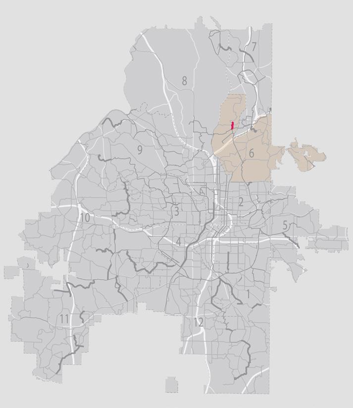
Trail Description:

The Peachtree Garden Greenway is an important primary network Beltline connection trail for the neighborhoods north of Peachtree Creek: Peachtree Heights, Peachtree Hills, Garden Hills and Buckhead. It begins at the Beltline and crosses north using an existing easement to reach Peachtree Hills Recreation Center. It then uses neighborhood streets in an all-ages, all-abilities design to reach Alexander Park where it enters from Alexander Drive and exits the park to the north providing access to Garden Hills Rec Center. It then scoots along Sunnybrook Park and uses the street network via Hills Drive to enter Bagley Park from the southeast. Considering the Bagley Trail coming from the west, a goal of the trail network in this area is to provide alternative travel for the popular Buckhead Baseball league events in Bagley Park that generate lots of traffic.
South Peachtree Creek Greenway

Existing Trails
Funded Trails
Phase 1 Trails
Phase 2, 3 Trails

End of Project

CHESHIRE BRIDGE

Trail Description:
The South Peachtree Greenway follows the South Fork of Peachtree Creek – a beautiful natural resource that has been heavily impacted by urban development. The biggest threats are invasive species and stream bank erosion from stormwater. An ecologically sensitive trail plan must address both of these issues. Phase 1 will connect from the south side of the confluence trail bridge to Faulkner Rd with a spur connection to Armand Park. A new bridge is proposed to cross the S. Peachtree Creek.
Length: 0.7 miles
Council District: 6, 7
Destinations:
• PATH 400 Trail
• Peachtree Creek Greenway
• Armand Park
Estimated Cost:
• Design: $221,000
• Construction: $6,135,600
Trails ATL Phasing Plan in Council District 7

Trail continues through District 8

South Peachtree Creek Greenway
Peachtree Creek
Blue Heron Greenway
Wieuca Trail

Existing
End of Project


It also gives students and families attending Sarah Smith Intermediate School an alternative way to and from the school. This street trail has long been discussed by neighborhood leaders in the North Buckhead Civic Association in their “Signature Streets of Buckhead” planning effort. A landscapeprotected sidepath along this route would repurpose the unprotected bike lanes and complete the alignment.
• Smith Intermediate Elem. Challenges:
• Community buy in and easement acquisition near Roswell Road.
Estimated Cost:
• Design: $193,000
• Construction: $6,962,400 400 400 Begin Project


communities of Brookhaven, Chamblee, Doraville and reach into Gwinnett County. The Atlanta portion is relatively short and currently in design for construction. A short segment near the Brookhaven border has design challenges that require additional funding. Phase 1 funding is recommended to ensure that the Atlanta portion can meet with the Brookhaven segment currently in design for construction.
• Peachtree Creek Greenway Challenges
• Constructability along Peachtree Creek in relation to a townhome community.
Estimated Cost:
• Design: $110,000
• Construction: $3,691,200
Trails ATL Phasing Plan in Council District 8

Blue Heron Greenway
Blue Heron Creek Greenway


Existing Trails
Funded Trails
Phase 1 Trails
Phase 2, 3 Trails Commercial Areas Public Parcels

Trail Description:
The Blue Heron Greenway is an east-west trail tracking a sewer line along Nancy Creek between Blue Heron Nature Preserve and Chastain Park. It will be a beautiful addition to the neighborhood and allow residents and visitors to enjoy both locations without having to drive between them. The Nature Preserve has nature trails and wetlands that are loved by the community with a very small parking lot that quickly fills up on pleasant days.
Length: 0.7 miles
Council District: 7, 8
Destinations:
• Chastain Memorial Park
• Blue Heron Nature Preserve
• Smith Elementary Challenges
• Easement acquisition
Estimated Cost:
• Design: $231,000
• Construction: $7,039,200
Trails ATL Phasing Plan in Council District 9

Whetstone Trail
Proctor Creek Greenway


Trail Description:
The Whetstone Trail segment in Phase 1 continues the existing Whetstone Trail that connects to the Silver Comet Trail. Extending along the upper reaches of Whetstone Creek, and crossing into a Georgia Power utility easement, the trail provides access to Lower Paul Park and to Whittier Mill Park where it connects with the Whittier Brick Trail. This connection provides access to Chattahoochee Brick Memorial Park and to the Riverlands Greenway.
Length: 1.4 miles
Council District: 9
Destinations:
• Whittier Mill Park,
• Moores Mill Commercial Area
• Marietta Road Senior Tower Challenges
• Easement acquisition Estimated Cost:
• Design: $278,000
• Construction: $9,362,400
Proctor Creek Greenway


Trail Description:
The Proctor Creek Greenway is a beautiful addition to Atlanta’s trail network. Today it extends from Bankhead MARTA Station up to the West Highlands neighborhood. It is programmed for a next segment up to Hollywood Road. Trails ATL includes the rest of the originally planned trail as it continues along Proctor Creek to and through Lillian Cooper Shepherd Park, makes a connection to Besto and Northwest Drives and proceeds to the Chattahoochee River where it is anticipated to meet up with the bridge crossing the river into Cobb County. Following the creek alignment, the Proctor Creek Greenway makes connections with other tributary trails, including the Terrell Creek Greenway, AD Williams Greenway, and Carey Park Greenway.
Length: 0.8 miles
Council District: 9
Destinations:
• Proctor Creek Greenway Challenges:
• Addressing the requirements placed on the EPA Consent Decree parcels limiting human activity.
Estimated Cost:
• Design: $98,000
• Construction: $5,718,000
Proctor Creek TerrellCreek
Proctor Creek
Trails ATL Phasing Plan in Council District 10

Lionel Hampton Trail
Adams Park
Emerald Utoy Greenway
Lionel Hampton Greenway

Existing Trails
Funded Trails

HAMILTON E. HOLMES


The Lionel Hampton Greenway segments in Phase 1 extend the existing trail in both directions. To the north, the new trail will traverse Fulton County property as a continuation of the greenway prior to becoming a sidepath and street trail that provides access to HE Holmes MARTA Station. To the south, the new trail will be a street trail with “calm street” treatments and possibly innovative street trail treatments providing access to Cascade Springs Nature Preserve via the Cascade Trail.
Council District: 10
Destinations:
• Lionel Hampton Nature Preserve
• Holmes Plaza
Challenges:
• Community buy in for the street trail segments. Coordination with GDOT and MARTA for access across MLK to HE Holmes station.
Estimated Cost:
• Design: $217,000
• Construction: $4,992,000
Lionel Hampton Gr
Existing
Funded
Phase
Phase


Segment2


Trail Description:
The Emerald Utoy Greenway is the centerpiece trail for West Atlanta. It stretches from the Beltline Southwest Trail near Lee Street – an area that is the headwaters for Utoy Creek – west to the Chattahoochee River. Segments 1, 2 and 3 pass neighborhood destinations such as the Patchwork City Farms community food garden, the Outdoor Activity Center, Barbara McCoy Park, and John A. White Park before joining an existing segment of trail to Lionel Hampton Nature Preserve. These segments also provide access to the Beltline for residents in nearby neighborhoods that currently have no reasonable walking/biking access.

Length: 3.5 miles
Council District: 10, 11, 12
Destinations:
• Beltline Southwest Trail
• John A. White Park
• Westview Cemetery Challenges:
• Easement acquisition and ecological concerns for a trail to be built on top of a sewer line.
Estimated Cost:
Segment 1 (0.6 mi):
• Design: $193,000
• Construction: $4,518,000 Segment 2 (1.8 mi):
• Design: $376,000
• Construction: $10,976,400
Segment 3 (1.1 mi):
• Design: $298,000
• Construction: $7,712,400
Emerald Utoy Greenway (Segment 4)


Trail Description:
The Emerald Utoy Greenway is the centerpiece trail for West Atlanta. It stretches from the Beltline Southwest Trail near Lee Street – an area that is the headwaters for Utoy Creek – west to the Chattahoochee River (passing through the City of South Fulton for the last leg). Along the way, the Emerald Utoy Greenway largely follows Utoy Creek as it gradually grows in water volume and drops in elevation to the equivalent of a 22-story building. Segment 4 proposed for Phase 1 extends the existing trail from the Lionel Hampton Nature Preserve west along city-owned property and primarily tracking a sewer line to Peyton Road. These segments will introduce West Atlanta to its watershed and provide opportunities for education and enjoyment.
Length: 1.2 miles
Council District: 10
Destinations:
• Lionel Hampton Park Challenges
• Easement acquisition and ecological concerns for a trail to be built on top of a sewer line.
Estimated Cost: Segment 4:
• Design: $325,000 • Construction: $10,629,600
Trails ATL Phasing Plan in Council District 11

Trail continues through Districts 11 and 12
Emerald Utoy Greenway
Emerald Cascade Greenway
Emerald Camp Creek Greenway
Emerald Falling Water Greenway
Adams Park Trail Trail continues through District 10


Trail Description:
The Emerald Cascade Greenway provides access to the Cascade Springs Nature Preserve – a beautiful and historical space that is somewhat challenging to access for many in southwest Atlanta. The greenway tracks the south fork of Utoy Creek from the City of East Point. A spur provides access to the Young Family YMCA and Adams Park. After skirting the edge of the Nature Preserve, the trail heads west tracking a sewer alignment and passes beneath I-285. After passing through neighborhoods on calm streets, the greenway provides access through all of Melvin Drive Park, bypasses new development, links to Fickett Elementary before ending on Campbellton Road across from Ben Hill Park and William Walker Rec Center (continuing to the Emerald Tell Greenway).


Trail Description:


Adams Park Trail is a long-planned trail that is especially important to the Cascade Heights neighborhood. It connects Campbellton Road (with a public library and the future MARTA BRT) to Adams Park Recreation Center along Delowe Drive as a street trail. It is intended to skirt behind Cascade Elementary School as a greenway providing a beautiful connection to the school and avoiding a steep grade on Venetian Drive. It proceeds again as a street trail on Venetian at Poole Road up to Cascade Road and Mays Drive, where it connects with the Cascade Trail and the Mays-Avon Trail respectively.
Phase 1 Trails
Phase 2, 3 Trails


Begin
Project
WESTGATE

End of Project

GREENBRIAR
Trail Description:
The Emerald Falling Water Greenway stretches from Campbellton Road up to the Cascade Greenway, passing through some of the city’s most beautiful and largely unknown greenspaces. The trail leverages a powerline easement, bypasses a pond and crosses Panther Trail to provide access to students at Therrell High School and Kimberly Elementary. It passes through and activates one of Atlanta’s newest parks – Falling Water. It uses another part of the powerline easement to give access to Cascade Park neighborhood residents before proceeding through a forested area just east of I-285, where it intersects with the Cascade Greenway providing east-west access between the Cascade Springs Nature Preserve and the neighborhoods west of I-285 with a beautiful underpass of the decidedly not beautiful I-285. Phase 1 is intended to connect Campbellton Road near the Greenbriar Mall area up to Falling Water Park. This will introduce neighboring residents and high school students to trails and the new city park.
Length: 0.8 miles
Council District: 11
Destinations:
• Daniel McLaughlin High
• Kimberly Elementary
• Westgate Shopping Center Challenges
• Easement acquisition
Estimated Cost:
• Design: $233,000
• Construction: $6,123,600
Phase 1 Trails
Emerald Falling Water Gr


Trail Description:
The Emerald Camp Creek Greenway is envisioned to connect Greenbriar Mall area to Camp Creek Marketplace via extensive greenspace along North Camp Creek. This greenway connects and activates several Parks and Recreation parcels including the North Camp Creek Nature Preserve. It also connects two schools via spur trails (Continental Colony and Deerwood) and provides access to Campbellton Road BRT stop at Greenbriar. Key neighborhoods include Princeton Lakes, Brentwood, and Greenbriar.
Length: 2.9 miles
Council District: 11 Destinations:
• Princeton Lake
• Continental Colony Elem.
• Stone Hogan Park
• Greenbriar Mall
• Epworth Towers Senior Living
Estimated Cost: Segment 1 (2.1 mi):
• Design: $431,000
• Construction: $14,898,000 Segment 2 (0.8 mi):
• Design: $272,000
• Construction: $6,654,000
Trails ATL Phasing Plan in Council District 12

Emerald Utoy Greenway
Trail continues through Districts 11 and 12
Trail continues through District 12 Existing
Central Southside Greenway
Lakewood Greenway
Trails ATL District 1 Phasing


Trail Description:

The Central Southside Greenway is a primary network trail connecting Southside Park to Downtown Atlanta crossing the Beltline at the terminus of MARTA’s Rapid A (Summerhill) bus line. This trail provides quality greenway access in District 12 to four schools (Heritage, South Atlanta High, KIPP Vision, and Dobbs). The greenway provides valuable links to South Atlanta High School, which has severely constrained access. The Southside Park connection is also crucial as existing roadway alignments do not offer a reasonable link between it and South Atlanta High School. The trail also provides a valuable connection between the park and the southside neighborhoods of South River Gardens, Blair Villa and Poole Creek, which currently have no walking or biking access to a park of regional significance in their own backyards.
Length: 2.6 miles
Council District: 12 Destinations:
• Rosel Fann Rec Center • Lakewood Greenway
• Browns Mills Golf Course
• South Atlanta High
• Southside Park
• Heritage Academy Elementary Challenges
• Easement Acquisition
Estimated Cost:
Segment 1 (1.1 miles):
• Design: $289,000 • Construction: $12,291,600 Segment 2 (1.5 miles):
Design: $323,000
Construction: $11,690,400
Trails ATL Implementation Strategies
Trails ATL is a vision to add over 420 miles of new trails to Atlanta’s existing and funded trail network. Phase 1 aims to build 35 miles of those trails within 10 years of formalizing a funding strategy. Trails ATL network expansion will require efficiency in delivery that addresses long-standing challenges related to procurement, project management, and intergovernmental coordination to achieve the goal of providing high-quality trail access to more Atlantans within a reasonable timeline. To do this, funds will need to be identified and city administrative processes streamlined. Possible funding mechanisms are listed below.
Trail Funding
Local funding is strongly preferred for implementing Phase 1 trail projects because it has fewer requirements. Federal and state money while valuable often ends up doubling the cost of building trails due to elaborate requirements designed to build highways, not trails. The City of Atlanta should therefore plan trail implementation to include a multi-year state and federal grants strategy that does not hamstring an efficient use of local funding sources. Well-thought-out, near-term local funding strategies combined with longer term state and federal grant strategies are highly attractive to private donors and form the basis of a successful public-private partnership. This partnership will be critical to maintaining momentum and keeping the overall Trails ATL network expansion plan on track.
Local Funding Sources
• Allocations within City/County budgets for parks, transportation, sewer and water
• Bond referenda
• Development impact fees
• Hotel-Motel taxes
• In-kind products and services
• Philanthropic grants
• Sales surtax funds
• Special Service District (SSD) funding
• Tax Allocation District (TAD) funding
• Transportation Special Purpose Local Options Sales Tax (TPLOST)
• Municipal Option Sales Tax (MOST)
• Bond using Park Impact Fund
• Trust fund interest and amounts remaining from completed projects
• Water sewer fund for trails on sewer easements
State of Georgia Funding Sources
• DNR Recreational Trails Program (RTP)
• Georgia Outdoor Stewardship Program (GOSP)
• Land and Water Conservation Fund (LWCF)
• Special project allocation
Federal Funding Sources
• Congestion Mitigation and Air Quality Improvement Program (CMAQ)
• Environmental Protection Agency (EPA) Community Change Grants
• Federal Transit Administration Capital Funds (FTA)
• Highway Safety Improvement Program (HSIP)
• Housing and Urban Development (HUD)
• Metropolitan Planning Organization (MPO) prioritizes and distributes federal transportation funding through the Regional Transportation Investment Generating Economic Recovery Discretionary Grant Program (RAISE)
• National Highway Performance Program (NHPP)
• Outdoor Recreation Legacy Partnership Program (ORLPP)
• Safe Routes to School
• Safe Streets and Roads for All
• Surface Transportation Block Grant Program (STBG)
• Transportation Alternatives Set-Aside (formerly Transportation Alternatives Program) (TA)
• Transportation Improvement Program (TIP)
• Trails ATL projects can also become part of the Community Work Program -- paid through the Capital Improvement Element (CIE); updated annually funded by user impact fees
Leveraging Existing Project Opportunities
Various government departments are already engaged with building trails. They have the knowhow and the experience to do great work. The key will be coordination to ensure that the City does not miss opportunities for advancing the Trails ATL vision at the same time other projects are being undertaken. The list below provides an example of the coordination needed between departments and Trails ATL:
Atlanta Department of Transportation (ATLDOT)
∞ Street paving – ATLDOT is aiming to make this more data driven and less political and to also seek money from ARC and GDOT. An example of how Trails ATL could coordinate is provided by Vision Zero legislation, which states “Department shall concur paving with bike lane striping during repaving projects.” Similar language should be adopted for Trails ATL.
∞ Mobility Bond - Atlanta’s recently approved Mobility Bond (designed to prepare the city for hosting World Cup Soccer games in 2026).
∞ Moving Atlanta Forward - The 2022 infrastructure package included money for trails currently under construction but also included money for sidewalk, traffic calming, and safe streets. Many of these projects are just getting underway. They should be designed with Trails ATL expansion in mind even if this means setting the stage for a future trail if money isn’t available to actually build the trail.
Watershed Management
∞ Westview – this neighborhood is slated for a stormwater system replacement that will require the rebuilding of a number of streets including S. Gordon, which are on the Trails ATL network. This is a perfect opportunity to work with the neighbors and the engineers to create safe and inviting bike/ped infrastructure.
∞ Valley of the Hawks – this project will create a new wetland to address flooding issues. The northern border of the project and the properties owned by DWM to the east have been identified as an ideal trail alignment for Valley of the Hawks. The proposed tunnel beneath the Beltline immediately to the west of the DWM project could make for a stunning trail and nature experience.
∞ Troy Street – this is another wetland project to address flooding. While the multi-use trail would not go through the greenspace, what is currently slated to be a sidewalk could be designed as a shared-use path connecting the City of Refuge to the Beltline.
∞ USACE (Mobile) – the US Army Corps of Engineers in the Mobile, Alabama office oversees the Chattahoochee River watershed. It is funding a program of projects along Utoy Creek that present an opportunity for collaboration with Trails ATL. Two of the Emerald Network trail projects – Utoy Greenway and Cascade Greenway – could leverage streambank stabilizations and stream channel diversions to create ecologically appropriate access to these green spaces.
∞ USACE (Savannah) – the US Army Corps of Engineers in the Savannah office oversees the South River watershed. The headwaters of the South River are in Atlanta near the intersection of I-85 and I-75. The Airport Trail is proposed along sections of the South River floodplain that are currently worn out parking lots overrun with invasive species. A collaboration between Watershed, USACE and Trails ATL could reclaim this area for the benefit of water quality and access to natural settings.
Georgia Department of Transportation (GDOT) Road Improvements
∞ Peters St – GDOT has agreed to safety improvements along Peters St and Whitehall St from Downtown to the West End. This is a great opportunity to coordinate key segments of the Olympic Trail.
∞ RDA – GDOT has agreed to safety improvements on this corridor that will result in unprotected bike lanes west of the Mall at West End. It is hoped that the congested segment of RDA between Lee St and Murphy can be configured as a protected facility as it will be the confluence of several trails: Olympic Trail, Paper Trail, Murphy Trail, the Grant Westview Trail and the East Lake West Lake Trail. This pinch point is created by the railroad which creates a barrier with very few crossing opportunities.
∞ 14th St – GDOT has agreed to safety improvements on this corridor from the Connector west to Northside Drive. This is intended to be protected infrastructure that creates a vital trail link between the burgeoning districts of Upper Westside and Midtown. Resident
support has been strong and will need to be sustained to keep this project viable.
∞ Other Corridors – Northside Dr, Moreland Ave and Peachtree St are all state highways with needs for active transportation infrastructure. Northside Dr has several Trails ATL network trail alignments – especially the North Atlanta Trail. Moreland Ave today cuts off Little Five Points, Reynoldstown, Kirkwood and East Atlanta from one another – the Moreland Trail addresses some of this disconnection but will require substantial coordination to bring to fruition. Peachtree St is home to Shepherd Center – the South’s premier physical rehabilitation facility where residents and staff lack quality street trail access
MARTA
∞ Campbellton Road – MARTA is investing several hundred million dollars in city-funded bus rapid transit infrastructure. Shared-use infrastructure has always been in scope but protected infrastructure has been resisted by MARTA leadership for some unknown reason. Protected trail infrastructure and transit are necessary partners especially in light of uncertain future transit funding and the diminished geographic scope of MARTA’s NextGen bus service.
∞ Cleveland Ave – MARTA has a bus route upgrade project along Cleveland Ave that will include some safe pedestrian crossings. This project should be delivered in a way that does not keep the City from creating shared-use trail access along the same corridor.
∞ Summerhill – while much of this BRT route is not suitable for a shared-use trail due to the design requirements of the bus route, aspects of the alignment north of Georgia Ave should be delivered in a way that does not keep the City from creating shared-use trail links northward into Downtown to the Piedmont Trail.
City Planning
DCP will play a vital role in the delivery of Trails ATL. Several of the trails will create significant economic development opportunities at catalytic development sites including Airport Trail, South Atlanta Greenway, the Emerald Network in Southwest Atlanta, etc. Development is an important potential source of trail funding and/or construction dollars and management. But it is imperative that affordability be considered now while the trail expansion program is in the earliest stages of planning. A key
lesson from the Beltline is that affordability cannot wait and that anti-displacement strategies need to be created in advance of trail implementation.
Parks and Recreation
DPR is engaged in the largest expansion of parks and recreation facilities in more than a generation. As it acquires new lands to expand existing parks or create new parks, Trails ATL should play a central role. Shared-use trails are the amenity that residents have said they want the most – to, through and around these parks.1 Linking parks together in a chain of trails makes them more accessible to a wider group of residents and visitors and showcases their beauty and enjoyability.
∞ Chattahoochee Brick Memorial Park, will soon be a regional destination and a great opportunity to connect the Riverlands Greenway and the Proctor Creek Greenway – providing active transportation alternatives to driving and parking.
∞ Falling Water Park is another new park opportunity where trails can provide access and programming. The Falling Water Greenway is part of the Emerald Network in Southwest Atlanta and could link the new park to Greenbriar Mall, Cambellton BRT, Therrell High School, Kimberly Elementary School, and the Cascade Springs Nature Preserve.
On-going and Forthcoming Private Development
∞ Vulcan – Vulcan’s planned development on Tell Road in District 11 has recently taken a step forward with an application for Development of Regional Impact (DRI) status for 800+ residences. This will be a valuable opportunity to advance the Emerald Tell Greenway connecting to Ben Hill Recreation Center.
∞ One West End – The former West End Mall redevelopment will be a destination and a pass through. It’s crucial to get street trail alignments into early designs.
∞ Centennial Yards – This development is well under way and will transform downtown. As a cluster of major destinations, it is imperative that the developer and key stakeholders understand the importance of protected street trails.
∞ And others - as new developments are proposed, it is critical that Trails ATL network expansion trails are included in the early planning. Trails ATL will seek to include trail alignments in the Atlanta Zoning Code to formalize this process.
Community Engagement
The value of the expanded Atlanta trail network envisioned in Trails ATL is that it will enable all trail users of all abilities to access all of Atlanta in a more sustainable and healthier manner. The trail network expansion will be accomplished gradually through the funding and implementation of individual trail projects. To ensure that adjacent residents, key stakeholders, and others who will use the trail have opportunities to provide input and feedback, Trails ATL recommends that public engagement be conducted for all trail projects. This engagement should reinforce an understanding of the role of the individual trail project in the overall trail network and the benefits of the trail network to all Atlantans.
Public engagement should adhere to the requirements and processes of the city department with jurisdiction over the individual trail project – potentially the Department of Parks & Recreation, the Department of Transportation, and/or the Department of Watershed Management. Engagement may be conducted by city staff or by the consultant team designing and engineering the individual trail project. Two types of engagement are considered: (1) neighborhood engagement using existing meeting processes; and (2) community engagement specific to a given project. These are outlined below:
Neighborhood Engagement
The city department(s) with jurisdiction over the trail project should inform and provide project-focused meeting schedules and design and construction updates as required to:
• Neighborhood Planning Units (NPUs): the relevant neighborhood planning units through the standard monthly meeting process; and/or
• Neighborhood Associations: the relevant civic organizations and associations.

Community Engagement
∞ Project Kickoff
o Outline the trail project in relation to the trail network.
o Present trail alignment options.
o Collect and evaluate public feedback.
∞ Public Information Open House at 30% Design
o Share the draft design concept with the public.
o Collect and evaluate public feedback.
∞ Public Information Open House at 90% Design
o Share the final design with the public.
o Share the project schedule and construction logistics with the public.
o Share the maintenance and policing plan with the public.
∞ Other Project Updates
o Share additional information and design/ construction updates with the public on a case-by-case basis.
∞ Ribbon Cutting
o Schedule a ribbon-cutting with the community, stakeholders, and elected officials to celebrate the completion of the trail.
Flyer for Trails ATL District 5 public meeting
Next Steps
Trails ATL is a citywide master planning effort to map out a trail network that will eventually cover more than 535 miles and provide 10-minute (1/3 mile) trail access to 95% of Atlanta residents. This transformational effort will take time, and the first steps are the most important. Upon adoption by City Council, the Trails ATL plan will proceed in the following steps:
• Identify an entity to oversee implementation of Trails ATL.
• Coordinate with ATLDOT to include Trails ATL alignments in the Comprehensive Transportation Plan and ensure that all future transportation projects consider the Trails ATL network and avoid missed opportunities.
• Ensure that the entire Trails ATL network is embedded in the various project lists managed by the Atlanta Regional Commission on behalf of state and federal funding entities.
• Develop the Trails ATL Phase 1 Implementation Plan to include a detailed funding strategy, detailed schedule, and a communications plan to keep the public informed.
• Start up the “trails conveyor belt” to ensure that there is always at least one Phase 1 trail in each production step: design, permitting and construction.
• Provide an update to the trail master plan in 2035.

Chastain Park PATH, Atlanta 2022

05 GUIDELINES
Design Guidelines
Design guidelines are not requirements. To address unique site complexities, trail planning needs the flexibility to solve problems on a case-by-case basis while staying true to the design intent. The guidelines below were established in coordination with members of the Core Team (Parks, ATLDOT, Planning, Watershed, and Beltline) and reflect guidance from AASHTO, NACTO, PROWAG, and MUTCD.1
Definitions
Pedestrians
Light Individual Transport (LIT)
Shared-use trails
People walking, pushing strollers, and using assistive devices such as wheelchairs.
People using bicycles, scooters, unicycles, skateboards, roller skates and the electrified versions of the same.
Shared-use trails are suitable to pedestrians and LIT users of all ages and all physical abilities. Shared-use trail design typically conforms to NACTO and AASHTO standards and related PROWAG with design variances for infeasibility.
Shared-use trails consist of ‘street trails’ and ‘greenways’ and provide recreation and transportation.
Greenways
Recreational greenways
Greenway spurs
Street trails
Pathways
Nature trails
Sidewalks
Greenways are shared-use and located away from public street rights of way on publicly and/or privately owned lands. They are intended to provide a park-like experience and usable for transportation and/or recreation.
Recreational greenways are shared-use trails and subsets of greenways where the primary purpose is the enjoyment of the space being traversed.
Greenway spurs branch off greenways or recreational greenways and provide access to neighborhoods, smaller parks, schools, or transit stations.
Located along public street rights of way and primarily serve transportation purposes of access and mobility (i.e., getting people to residences, businesses, and public spaces.)
Main use area of a trail excluding buffers or borders.
Nature trails need to be suitable for all ages and physical abilities but do not need to conform to AASHTO or PROWAG standards. Nature trails are not addressed in this plan.
Sidewalks are for pedestrians and usable by LIT users aged 12 or younger. Sidewalks are not addressed in this plan.
Based on AASHTO standards, bi-directional shared-use trails are a minimum of 10’ wide, however, they are typically 12’ wide and designed at 14’ wide or wider in heavy use areas to enable comfortable passing and Exceptions to trail width requirements (minimum 8’) apply for short distances to bypass physical obstacles and are allowed upon approval of the reviewing department. When built in natural settings, shared-use trails should prioritize natural resource protection and limit construction


Cross section of an elevated greenway
1 AASHTO Guide for the Development of Bike Facility, 5th Edition (2024), Section 6.4.3 Recommended Shared-use Path Width.


AASHTO Guide for the Development of Bike Facility, 5th Edition (2024), Section 7.3.4 Bike Lane Width.


Cross section of 25’ Shared Street
Example of custom sign for shared two-way lane
Vision for a proposed shared street (existing 30’ curb to curb width) on Valley Rd in Atlanta
Cross section of 35’ Shared Street with Parking2
2 Advisory shoulders with the presence of a sidewalk are called advisory bike lane.
Shared-Use Trail Materials
Surface Considerations
Shared-use trails must be designed to enable access for people using wheelchairs and by maintenance and emergency vehicles.
Concrete is used for shared-use trail components as follows:
∞ Pathways;
∞ Elevated structure decks;
∞ Retaining walls (surface treatments to match existing);
∞ Pervious concrete to be considered to assist with storm-water drainage in locations required by permitting agency or deemed valuable in the design process to include a maintenance plan; and
∞ Concrete pour is to have a minimum depth of 5” at 3,000 pounds per square inch (psi).
Other pathway surface materials:
∞ Asphalt – due to maintenance issues related to cracking, asphalt is recommended only for street trails where asphalt is the existing surface; when used it should include a repaving plan.
∞ Compacted dirt, graded aggregate base (GAB) or slate chip mix (if required by permitting agencies) are to include a maintenance plan (minimum trail widths and wheelchair usability guidelines still apply).
Materials not recommended for pathway surface:
∞ Brick pavers – due to maintenance issues, these are generally not recommended for multi-use trails and should be used sparingly in elevated street crossings and at ADA ramps where truncated pavers can alert trail users.
∞ Flexipave (recycled rubber tire material) – due to the high cost of installation and maintenance, this material is generally not recommended for shared-use trails and should be used sparingly in amenity areas.
∞ Wood decking – due to maintenance issues and because it is low friction when wet, wood decking for elevated structures is not recommended.


Concrete pathway at South River Greenway in Atlanta
Elevated structure with concrete deck Proctor Creek Greenway in Atlanta
Freedom Trail in Atlanta
Centerline Considerations
For greenway trails:
∞ No centerline is required.
∞ If a centerline is to be used, then a continuous 4” sandblasted line bordered by saw cuts is preferred. If necessary to reduce costs, yellow paint (as defined in MUTCD 9E.13.01) is acceptable.
For sidepaths and two-way separated bike lane street trails:
∞ Provide a striped centerline to indicate the facility is a shared-use trail and not a sidewalk.
∞ Centerline stripe to be painted yellow as defined in MUTCD 9E.13.01.
Landscaping Considerations
Trees
∞ Include trees from the city’s preferred list and consider species that limit maintenance needs.
∞ Place trees with regard to future growth and impact on lighting and security camera views.
∞ Space trees more densely than the existing ordinance allows upon approval by reviewing department in the following scenarios:
o Trees are placed in an open space along a greenway to achieve species diversity, trail definition, and a layered natural forest look
o Trees are placed in the landscape buffer along street trails for establishment of vertical barriers and sense of safety from traffic.


Greenways
∞ Use a plant palette that minimizes maintenance and reflects the environment the trail is passing through; and avoid monoculture.
∞ Plan for invasive species monitoring/management to protect natural areas and landscaped borders following construction-related disturbance.
∞ In natural areas minimize the limits of construction disturbance to reduce the need for restorative landscaping.
∞ Typical clear zones are 3’ (minimum 2’) on either side of the pathway with the expectation that they are mowed. Exceptions to mowing should be considered in nature preserves and heavily forested areas.
Street Trails
∞ Typical 6’ (or greater) buffer between roadway and pathway. The buffer to be reduced only in situations where its existence would reduce trail width below 9’ and only upon approval of the reviewing department.
∞ Use native shade trees and native seed mix where feasible; allow ornamental shade trees in locations not suitable for native shade trees. Avoid monoculture if possible.
Example of yellow painted centerline on PATH 400
Example of planted shoulder along the Beltline Southwest Trail
Example of sandblasted centerline
Shared-Use Trail Access
General Considerations
∞ To support people with disabilities, provide signed parking at or near greenway access points.
∞ ADA and PROWAG1 regulations are to be followed for access to trails wherever possible. Trails designated as transportation routes must conform to “pedestrian access route” guidance unless technically infeasible.
∞ A minimum vertical clearance of 10 ft is preferable. However, certain agencies may require more for maintenance vehicles.
∞ Typical maximum of 5% slope with higher for short distances in rare circumstances. For trail segments exceeding 5% slope, create 10’ long level segments every 200’.
∞ Typical maximum of 2% cross slope.
∞ 5’ minimum frontage zone where buildings front trails to provide space for doors.
Parking Considerations
∞ Encourage non-vehicular, shared-use trail access.
∞ Encourage use of existing parking facilities.
∞ Evaluate parking needs near trailheads and consider resident-only parking permits if needed
∞ In commercial areas with high demand for parking primarily satisfied by street parking, the city should consider promoting or supplying off-street parking to free up public right of way for street trails.
Shared-Use Trail Access


Respect for property rights and community trust is central to implementation of this plan. Trails ATL recommends that the City of Atlanta commit to acquiring land and trail access through cooperative, transparent processes.
∞ Voluntary Access - The city will prioritize voluntary land acquisition, easements, and partnerships with willing property owners and community stakeholders. Outreach and communication will be used to build mutual understanding and support.
∞ Eminent Domain as a Last Resort - The use of eminent domain will only be considered when all other reasonable options have been exhausted and when the public interest clearly justifies its necessity. Even then, such measures must be pursued with transparency, fairness, and full legal due process. In the event of its use, all property owners will be treated with respect and provided
fair and just compensation as defined in the Uniform Act.2
∞ Zoning Integrity Commitment - Trails ATL will not be used as the sole justification for zoning changes to adjacent properties for economic development purposes. Trail development must prioritize community benefit, environmental quality, and equitable access over speculative land use changes. Any proposed zoning actions must stand on their own merit and follow established planning and community review processes.
Shared-Use Trail Ecology
Trail design should celebrate and enhance natural surroundings while providing respectful access to those in need of outdoor spaces. When traversing natural areas, trail design should follow existing disturbance to minimize ecological impact and provide an opportunity for parallel projects to address broader ecological challenges. Other topics are discussed below:
Special Considerations for Stormwater Management
∞ Use stormwater management techniques pertinent to their settings and designed to manage storm event water volumes.
∞ Healthy, vegetated riparian buffers provide stormwater management and water-quality benefits. To maximize these benefits, new disturbance within these areas should be minimized.
∞ Incorporate shared-use trail networks into stormwater management system redesigns for streets and neighborhoods.


∞ Design stormwater management inlets and grates in ways that do not compromise user safety on the shared-use trail network.
∞ Ensure street trail design does not compromise stormwater flow to inlets.
Special Considerations for Trees
∞ Trail design should avoid unnecessary impacts to mature trees and significant canopy areas. Where impacts are unavoidable, a replanting plan will be provided (during a project’s design phase) and will follow all city ordinances and applicable state and federal requirements.
∞ Overhead tree canopy connection over all trails through forested areas should be strongly considered to maximize rainfall interception and stem flow which results in improved infiltration.
∞ Limit the removal of trees (especially mature healthy trees) and focus on tree health and critical root zones, through the extensive use of root bridging and other techniques.
Special Considerations for Stream Banks and Wet Areas
∞ Conform to all city ordinances and state and federal requirements.
∞ Coordinate with streambank remediation projects conducted by DWM, USACE and/or State EPD.3
∞ Use elevated structures to minimize impact of trail on wet areas.
Infiltration
The use of an infiltration system facilitates the drainage of stormwater away from a nearby creek by directing it across the trail and into a gravel drain. This system enables runoff to infiltrate beneath the trail before reaching the creek. This approach is particularly suitable for trail locations that are close to a stream buffer.
Structural Slabs
Structural slabs provide an environmentally friendly method of creating a drainage swale beneath a trail. They can also be used to span over minor tributaries.
Tree root bridging allows the trail to come close to specimen trees without causing harm, while a porous concrete edge aids infiltration. The image above shows pervious concrete strip along trail edge on Tanyard Creek Trail.
Pervious concrete used as trail pavement
Special Considerations for EPA Consent Decree Properties
∞ All trail design within these properties should adhere to the Greenway Acquisition Plan (see p. 17) , including approval of trail plans by EPA and EPD.
∞ If conflicting, Consent Decree requirements should supersede Trails ATL guidelines within these properties.
∞ Prevention of non-point source pollution and minimization of impact should be prioritized within all Consent Decree properties.
∞ Trail alignments should be focused on previously disturbed areas.

DWM Greenways (Consent Decree)
Trails ATL and Department of Watershed Management “Greenways”
Amenity Considerations
∞ Exact locations of all amenities are to be determined in the trail design phase.
∞ Encourage the trail sponsor (entity managing the trail project) to provide restrooms, waste/recycling stations, water fountains, and pet waste stations at select greenway entry points that can serve dual-use opportunities with parks.
∞ Provide benches and viewing platforms strategically along trails.
∞ Bike racks should be provided at logical destinations where a user would reasonably be expected to leave a bike unattended. Typical bike racks should be u-shaped and anchored in concrete. Bike rack placement should follow the city’s bike rack installation guidelines.1
∞ Create bicycle/scooter riding practice tracks at select parks to enable children and adults to safely learn how to ride. These should include lane markings, curbs, signage, and a stop light to create environments similar to what will be encountered in the field. Consider Shirley Clarke Franklin Park as a location for a practice track as an adjunct to the mountain biking facility.


1 chrome-extension://efaidnbmnnnibpcajpcglclefindmkaj/https://www.atlantaga.gov/home/showpublisheddocument?id=31948
Bike rack and bench at a Westside Beltline Connector pocket park. Bike fix station at Peachtree Creek Greenway
Pocket park on PATH 400 trail in Buckhead, Atlanta
Benches, picnic tables and hammocks at Peachtree Creek Greenway
Shared-Use Trail Network Communications
Branding Considerations
∞ Follow City of Atlanta departmental and other branding standards.
∞ Use simple, non-distracting branding.
∞ Use a name-based system, not a numbered system.
Naming Convention Considerations
∞ Use simple, easy-to-recognize names with as few letters as possible to simplify communication.
∞ Use names of key destinations, neighborhoods, natural features and/or major streets (e.g., “Airport Trail”, “Thomasville Greenway”, and “Utoy Greenway”).
∞ Use endpoint to endpoint names to assist with wayfinding (e.g. “Giant Westview Trail”, or “East Lake/West Lake” connecting East Lake neighborhood to West Lake neighborhood).
∞ Use “Trail” for shared-use trails that are primarily street trails (and more likely transportation focused); and “Greenway” for shared-use trails that are primarily greenways (and possibly recreational greenways).
∞ For street trails, “Trail” replaces “Street” or “Road” (e.g., “Campbellton Trail” not “Campbellton Road Trail”).
Wayfinding Considerations
∞ Provide wayfinding signage at all decision points, access points and in-between points for longer trails.
∞ Use whole miles when indicating distances.
∞ Use acronyms when necessary to simplify signage (e.g., “SPCG” for South Peachtree Creek Greenway).
∞ For destinations along a trail, focus wayfinding on parks, schools, MARTA stations, commercial districts, stadiums, trail endpoints, and restrooms.
∞ Develop simple trail network maps and trail specific area maps (using “star symbols” to denote current location) at greenway access points and key trail junctions. Install signage where it does not add to visual clutter or obstruct sightlines.
∞ On all signage, consider aluminum panels with replaceable plastic graphics for ease of maintenance.
∞ Provide visible mileage markers (location IDs) for safety, emergency communication, and maintenance purposes.
∞ Encourage the use of pavement markings on trail surfaces at decision points as a secondary and less costly way to show spurs to destinations.
Storytelling Considerations
∞ Deploy plaques to tell the story of Atlanta’s social and ecological history, botanical references, stream bank restoration projects, climate change, etc.
∞ Print information on plaque materials that are easy to maintain and replace.
∞ Place storytelling plaques in ways that are not distracting and do not block views.
∞ Minimize the amount of text and provide electronic solutions such as QR codes where applicable.
Community Participation Considerations
∞ Encourage community participation related to trail design details, construction updates, and to address issues such as parking, antisocial behavior, lighting, security cameras, etc.
∞ Provide community updates throughout the life of the shared-use trail network build out. Provide coordinated updates from city staff at monthly NPU meetings and other public meetings and events.

Information kiosk example, Proctor Creek Greenway, Atlanta
Shared-Use Trail Safety
Design Safety Considerations
∞ Conform to the most recent version of the MUTCD and other relevant regulatory standards including AASHTO.1
∞ Uncontrolled or mid-block trail crossings should follow guidance provided by FHWA.2
∞ Pedestrian safety takes precedence over LIT3 user convenience, but should not create unsafe conditions for LIT users. A negative example is where pedestrian “bulb outs” force LIT users to merge with motorists at intersections.
∞ Safety of pedestrians and LIT users (collectively “vulnerable road users”) takes precedence over motorist convenience and street parking needs.
∞ Avoid creation of tripping hazards for pedestrians, impediments for wheelchair users, or increased fall risks for LIT users.
∞ Design trail curves based on speed limits referenced in policy guidelines section.
∞ Bus stop interactions should follow guidance provided by AASHTO.
∞ To the extent practicable trail design should follow CPTED4 principals.
Lighting Considerations
∞ Where students use shared-use trails as transportation to school, ensure sufficient lighting is available at a minimum from 6:00 a.m. to 8:00 p.m. on school days.
∞ Where shared-use trails are primarily for transportation, ensure lighting is sufficient.
∞ Where shared-use trails are primarily for recreation, evaluate lighting on a case-by-case basis.
∞ Provide dimming and motion detection and use non-glare, fully hooded trail-focused lighting when available.
∞ Ensure lighting plans and security camera plans overlap and security needs are considered.
Security Camera Considerations
∞ Where cameras are deemed necessary, security professionals are to identify security camera locations using cost/benefit analysis.
∞ Link any security cameras to APD’s camera network and provide a security camera maintenance plan that is agreeable with Atlanta Information Management (AIM).
∞ Ensure that separate lighting and security camera plans overlap.


1 AASHTO Guide for the Development of Bicycle Facilities, 5th Ed., 7.9.14 Transit Stops, p. 7-54. 2 https://highways.dot.gov/sites/fhwa.dot.gov/files/2022-07/STEP_Guide_for_Improving_Ped_Safety_at_Unsig_Loc_3-2018_07_17-508compliant.pdf
Example of security camera mounted on pedestrian light pole, Beltline Westside Trail
Example of lights installed for trail underpass on South River Greenway at Clairmont Road
Railing Considerations
∞ 42” minimum height.
∞ Encourage see-through railings for trail users whose line of sight is below the top railing.
∞ Design should discourage climbing.
∞ Use materials that reflect the trail environment. Conduct a cost-benefit analysis to determine railing materials with a preference for steel.
Vehicle Restriction Considerations
∞ Bollards are to be strategically placed (such as trail or entry points) to provide a barrier to fourwheel vehicular access. Use removable bollards with familiar locking codes so that emergency and maintenance personnel have access. Bollards should be powder coated steel with reflective materials to bring awareness to their existence for trail users.
∞ Kiss Gates and/or Chicanes could slow LIT user vehicles at areas of heavy demand or where LIT user speeds are becoming problematic. If a kiss gate is used, then install a side gate for emergency and maintenance vehicle access. Design to PROWAG specifications.


Example of post & cable handrail with corten finish, Northwest Beltline Connector
Example of bollards at trail entry points, Westside Beltline Connector
A combination with a steel-backed timber guardrail, bollards, and boulders were used for safety and vehicle restriction for Beltline Westside Trail along Marietta Blvd.
At-grade Crossings
The following are derived from the U.S. Federal Highway Administration (FHWA) for the implementation of pedestrian safety measures to enhance safety at roadway crossing locations.1
Marked Crosswalks
It is preferable to have marked crosswalks in areas with significant pedestrian activity, such as signalized intersections and locations with appropriate levels of pedestrian and vehicular traffic. Crosswalks with high visibility contribute to enhanced pedestrian safety by increasing motorist awareness of trail crossings in areas where drivers may not be accustomed to encountering bicyclists and pedestrians.
For uncontrolled crossing locations, such as multilane roadway crossings where the annual average daily traffic (AADT) surpasses 10,000 vehicles, additional safety measures are necessary to further enhance pedestrian safety.
Crossing Islands
Crossing islands are road medians with refuge areas. They allow trail users to concentrate on one direction of traffic while crossing a multi-lane road. The implementation of crossing islands is recommended for midblock pedestrian crossings, particularly on roads with four or more travel lanes where speed limits exceed 35 mph, and/or where the Annual Average Daily Traffic (AADT) is 9,000 or higher.
Trail crossing islands should be a minimum of eight feet wide and have ample length to allow for queuing. Ramps leading up to the cut-through should include detectable warning surfaces. In areas with on-street parking, curb extensions may be constructed in conjunction with crossing islands.
Raised Crossings
Raised crossings, or raised intersections, are ramped speed tables that span the entire width of a roadway or intersection. They enhance the visibility of pedestrians in a driver’s field of view, lower vehicle speeds, and improve yielding. This preventative measure has the potential to decrease crashes by up to 45%2
Raised crossings are typically installed on roads with two or three lanes with speed limits of 30mph or less, where the AADT is below 9,000. The typical design of raised crossings includes a 10-foot-wide tabletop with 5% minimum running slope for both approach ramps. Detectable warning surfaces should be installed on both sides of the trail leading to the intersection of the speed table. When installing raised crossings, drainage and stormwater flows must be addressed to avoid flooding, puddling and/or erosion.
Pedestrian Hybrid Beacons (PHB) and Rapid Flashing Beacons (RRFB)
PHBs are effective on roads with three or more lanes with AADT above 9,000. PHBs are highly recommended for roadways with speed limits above 40 mph.
RRFBs should be considered for all midblock and intersection crossings where there are no existing traffic signals or no all-way stop requirement. RRFBs are particularly effective at multi-lane crossings with speed limits below 40 miles per hour. Trail crossing warning signs in advance of the crossing are required to notify users in all directions.


Example of Pedestrian Hybrid Beacon, Spanish Moss Trail, SC
Example of a mid-block crossing with Rectangular Rapid Flashing Beacons (RRFBs) and raised crosswalk (speedtable) on Chastain Park Avenue.
Policy Guidelines
Shared-use trail policies have evolved over the years based on experience and data gathered from the existing components of Atlanta’s trail network. The following guidelines were developed in collaboration with members of the Core Team (Parks, DOT, Planning, Watershed and Beltline), other city staff, and key stakeholders.
Hours of Operation
∞ Recreational greenways and related spur trails are open from dawn to dusk, the same as City of Atlanta parks.
∞ All other trails and trail segments remain open at all hours.
Vehicle Restrictions
∞ Emergency or maintenance vehicles are allowed
∞ Four-wheeled vehicles such as golf carts, ATVs, and pedal pubs are prohibited.
∞ Motorized vehicles are prohibited.
Addressing Antisocial Behavior
∞ Speed limit for LIT on all trails is 20 mph.
∞ Create communications campaigns to reduce anti-social behavior (e.g., speeding or passing too closely) on shared-use trails.
Ensuring Efficiency
∞ Create standard trail agreement template between shared-use trail owners and other governmental partners (e.g., Atlanta Public Schools, Atlanta Housing Authority, Invest Atlanta, MARTA, and Habitat for Humanity).
∞ Exempt trails approved in the Trails ATL citywide plan and included in the Comprehensive Development Plan from the City of Atlanta’s 75’ stream buffer regulations.
Commercial District Parking Plans
∞ Parking is an often emotional issue and it must be considered when evaluating street trails. However motorist convenience should not trump safe access to key destinations for non-motorists.
∞ Commercial districts, including Virginia Highland, Little Five Points, East Atlanta Village, Castleberry Hill, West End, and others, should develop offstreet parking plans to replace parking that may need to be removed for the provision of safe walking and biking facilities.


Mitigating Collateral Effects
∞ Coordinate across city departments to ensure that shared-use trail development helps achieve city goals related to equity, affordability, and climate change.
∞ Encourage city departments to conduct advance planning and community outreach to limit the potential for displacement of long-term residents resulting from the addition of high-quality trails.
∞ Establish a zoning overlay for the shared-use trail network to ensure the long-term integrity of the trail network expansion plan and to encourage developers to invest in trail-oriented development.
∞ Zoning overlay should provide flexibility in trail design while maintaining property owners’ ability to profitably develop their properties within the overall confines of the zoning code
Example of warning signs at trail access point
Example of kiosk trail rules signage
Shared-Use Trail Maintenance Recommendations
Trail maintenance concerns were raised by several stakeholders and members of the public during the planning process. The recommendations below were developed in coordination with key city maintenance staff and experienced trail designers.
∞ Trail maintenance, as referenced, includes the consideration of the physical trail itself and all associated infrastructure, landscaping, and management of natural areas adjacent to or directly impacted by the trail.
∞ Trail maintenance should be separate from, but paired with, broader invasive species management plans in natural areas.
∞ Trail design should consider long-term maintenance needs and prioritize upfront capital investments that support minimization of impacts to natural areas and reduce long-term operating costs and complexity. Trail materials should undergo a cost/benefit analysis that considers long-term operating costs.
∞ Prefer low complexity, low operating cost materials over more expensive, complicated, more aesthetic materials for trail design. Shared-use trail design must keep maintenance top of mind.
∞ Key stakeholders should develop a coordinated, shared-use trail maintenance plan with
responsibilities defined by department to include success metrics that prioritize proactive preventative maintenance. Key stakeholders include: city departments (Parks, Transportation, Watershed Management, and Public Works), GDOT, commercial improvement districts, and major institutions with trails (eg. Georgia Tech).
∞ Consider expanding the role of trail maintenance crews to include inspections, reporting, invasive species identification, and preventative maintenance. This could be coordinated with public safety and community engagement efforts (e.g., park rangers).
∞ Label key city assets such as sewer heads with publicly visible identification tags and ways to communicate any issues back to the relevant department.
∞ Promote the use of 3-1-1 for maintenance and/or develop reporting tools with geospatial referencing to streamline communication and reduce response time.

Freedom Trail in front of Homage to King sculpture.

Joggers on the Chastain PATH
Acknowledgements
While preparing the Trails ATL plan, the PATH Foundation has received the support of many hundreds of Atlantans without whom the plan could not have been completed. We would like to extend special thanks to the following:
Office of Mayor Andre Dickens
Andre Dickens
Theo Pace
Courtney English
David Edwards
Susan Rutherford
LaChandra Burks
Chandra Farley
John R. Seydel
Gabrielle Slade
Mayor
Deputy Chief of Staff
Chief Policy Officer
Neighborhood Policy
Neighborhood Policy
Deputy Chief Operating Officer
Chief Sustainability Officer
Deputy Chief Sustainability Officer
Deputy Chief Equity Officer
City Council Members
Doug Shipman
Jason Winston
Amir Farokhi
Byron Amos
Jason Dozier
Liliana Bakhtiari
Alex Wan
Howard Shook
Mary Norwood
Dustin Hillis
Andrea Boone
Marci Collier Overstreet
Antonio Lewis
Matt Westmoreland
Michael Julian Bond
Eshé Collins
Council President
District 1
District 2
District 3
District 4
District 5
District 6
District 7
District 8
District 9
District 10
District 11
District 12
At-Large At-Large At-Large
Department of Parks and Recreation (DPR)
Justin Cutler
Keith Hicks
Tara Buckner
Rachel Maher
Dr. Gaylan Williams
Doug Voss
Taryn Heidel
Major Tony Singh
Sandi Edmond
Phillip Smith
Shanesha Blount
Bridget Johnson
Angela Jones
James Patterson
Jordan Patterson
Commissioner
Director of Park Planning & Design
Urban Planner III
Deputy Commissioner
Deputy Commissioner
Deputy Commissioner
Arboricultural Manager
Park Ranger Commander
Sr Report Analyst
Community Outreach Coordinator
Community Outreach Specialist
Business Analyst
Data Analyst
GIS Analyst
Intern
Department of Watershed Management
Al Wiggins
Melissa Ferretti
Amanda Hallauer
John Ahern
Tamara Graham
Commissioner
Director, Office of Watershed Protection
Former Manager
Greenway Manager
Environmental Program Manager
Hunter Howell
Mikita Browning
Environmental Program Manager
Former Commissioner
Department of City Planning
Jahnee Prince
Janide Sidifall
Andrew Walter
Nathanael Hoelzel
Leah LaRue
Doug Young
Keyetta Holmes
Jessica Lavandier
Andrew Walter
Daniel Vasquez
Commissioner
Deputy Commissioner
Assistant Director, Special Projects
Neighborhood Planning Manager
Director, Neighborhood Planning Units
Director, Office of Design
Director, Zoning and Development
Assistant Director, Zoning & Development
Special Projects Manager
Neighborhood Planning
Department of Transportation (ATLDOT)
Solomon Caviness
John Saxton
Betty Smoot-Madison
Lenor Bromberg
Cole Smith
Chris McIntosh
Chris Rome
Carla Smith
Nichole Hollis
Commissioner
Director, Mobility Planning
Deputy Commissioner
Deputy Commissioner
Vision Zero Manager
Urban Planner III
Transportation Engineering Director, Sr
Program Management Officer
Safe Routes to School Manager
Technical Advisory Committee
(not listed above)
Dan Drake
Chris Salley
John Skach
Michael Halicki
Andrew White
Rebecca Serna
Connor Booth
Joe Cavins
Eric Meyer
Roberta Moore
Greg Giuffrida
Dr. Na’Taki
Osborne Jelks
Darryl Haddock
James Curtis
Janelle Wright
Sidney Douse
Corentin Auguin
Ansley Goddard
Facilities Director, Atlanta Public Schools
Operations, Atlanta Public Schools
Director of Planning & Design, Atlanta
Housing Authority
Executive Director, Park Pride
Park Planner, Park Pride
Executive Director, Propel ATL
State Ped & Bicycle Engineer, GDOT
District Design Engineer, GDOT
Planning Coordinator, Active Transportation, Atlanta Regional Commission
Field Representative, The Conservation Fund
Communications Director, MARTA
Executive Director, West Atlanta Watershed Alliance
Special Projects Director, West Atlanta
Watershed Alliance
Advocate for People with Disabilities,
Shepherd Center
Environmental Justice Program Manager, West Atlanta Watershed Alliance
Communications, MARTA
Bus Stop Planner, MARTA
Senior Planner, ARC
Acknowledgments
Focus Group Participants
Community Improvement Districts
Dan Hourigan
Denise Starling
Jim Durrett
Elizabeth Hollister
Adeline Collot
Kyethea Clark
Shayna Pollock
Jack Cebe
Nichole M. Hall
Lauren Welsh
Gerald McDowell
Parks
Doug Widener
Rosa McHugh
Sandra Kruger
Jay Wozniak
Catherine Spillman
Michelle Blackmon
Richard Harker
Valerie Ikwhan
Carden Wyckoff
Denise Cardin
Janelle Wright
Chinelo Arinze
David Lloyd Davis
Midtown Alliance
Livable Buckhead
Buckhead CID
Upper Westside CID
Upper Westside CID
ATLDOT
ADID
ADID
West End CID
Little Five Points Alliance
Aerotropolis
Piedmont Park Conservancy
Chastain Park Conservancy
Olmstead Park Alliance
Trust for Public Land
Atlanta Memorial Park Conservancy
Grant Park Conservancy
Oakland Cemetery
State Parks & Historic Sites
Propel ATL
Blue Heron Nature Preserve
West Atlanta Watershed Alliance
Cascade Springs Nature Conservancy
Cascade Springs Nature Conservancy
Colleges & Universities
Rakesh Vakamudi
Jason Gregory
Laurence Brennan
Tatyana Goddard
Atuarra McCaslin
Dr. Michael Hodge
Alicia Bates
Andre Bertrand
Arthur Frazier
Jerome Rowland
Bonita Dukes
Dr. Thompson-Sellers
Walter Kolis
Adele Clements
Georgia State
Georgia Tech
Georgia Tech
Georgia Tech
Atlanta University Consortium
Atlanta University Consortium
Morehouse School of Medicine
Morehouse
Spelman
Morris Brown
Clark Atlanta
Atlanta Technical College
Emory
Emory
Atlanta Police Department
Major Reginald Moorman
Major Benjamin Vayens
Major William Ricker
Major Antonio Clay
Major Christian Hunt
Major Andrea Webster
Major Jeffrey Cantin
Lt. Courtney Murphy
Lt. Frederick Harper
Officer Anthony Singh
Zone 1
Zone 2
Zone 3
Zone 4
Zone 5
Zone 6
Major Jeffrey Cantin
Path Force
Path Force
DPR
Primary and Secondary Schools
Ms. Kimberly Wiles
Ms. Alisha Torres
Ms. Lisa Hill
Ms. Melanie Johnson
Dr. Wilhemina Register
Dave Fortier
Stacy Howze
Gray Kelly
Victor Panchuk
Social Advocacy
Katie Harmon
Suzanne Burnes
Heather Hussey-Coker
Katrina Julien
Freesia Young
Alison Johnson
Carla Lewis
Environmental Groups
Eli Dickerson
Corliss Claire
Kimberly Estep
Jackie Echols
J Olu Baiyewu
Madison Cummiskey
Jason Lathbury
Ben Emanuel
Chandra Farley
Jared Teutsch
Erich Melville
Housing
Natallie Keiser
Daphne Bond-Godfrey
Karen Babino
Amanda Rhein
Alan Ferguson
Lee Harrop
Saxton Phillips
Karen Patten
Matt Johnson
Jennifer Fine
Semira Ajani
Atlanta Public Schools
Atlanta Public Schools
Atlanta Public Schools
Atlanta Public Schools
Atlanta Public Schools
Pace Academy Galloway
Lovett
Westminster
Shepherd Center
Partnership for Southern Equity
Groundwork Atlanta
Community Foundation
Housing Justice League
Housing Justice League
ECO-Action
Park Pride
Adams Park Foundation
South Fork Peachtree Creek Alliance
South River Watershed Alliance
City of Atlanta – Urban Agriculture
Trees Atlanta
Sierra Club
American Rivers
City of Atlanta- Sustainability
Birds Georgia
The Conservation Fund
House ATL
ULI Atlanta
Atlanta Land Trust
Atlanta Land Trust
Habitat for Humanity
Westside Futures Fund
Atlanta Urban Development Corp
Atlanta Urban Development Corp
Atlanta Housing Authority
Invest Atlanta
Invest Atlanta
Acknowledgments
Focus Group Participants Consulting Team
Transportation
Ansley Goddard
Bruce K. Morton
Harold Morton
Patrece Keeter
Josh White
Caleb Wittenmyer
Regan Hammond
Corentin Auguin
Byron Rushing
Gavin McLintock
Atlanta Regional Commission
Resident of West Atlanta
Resident of West Atlanta
DeKalb County Transportation
Peachtree Creek Greenway
DeKalb County Parks
VHB – Statewide Rural Bike Ped Plan
MARTA
DeKalb County Bike Ped Plan
Shepherd Center
Supporting People with Disabilities
James Curtis
Ashley Finch
Carden Wyckoff
Maggie Frederick
O’Ree Crittenden
Stephany Sance
Eric Gray
Neighborhood
Shepherd Center
ATLDOT
Propel ATL
Advocate
Access 2 Independence
Shepherd Center
Catalyst Sports
Planning Units
W. Brinklet Dickerson
Dr. Nancy Bliwise
Zack Gober
James “Jim” Martin
Courtney Smith
Debbie Skopczynski
Torrey Sumlin
Khalifa Lee
C. Delores Furlow
Anissa Ferrell
Arthur Toal
Leonard Watkins
Forrest Coley
Amy Stout
Joe Schleupner
Reginald Rushin
David Getachew-Smith
Rita Harden
Quadrus Black
Angela Clyde
Caitlin Barringer
Sky Hassan
Zachary Adriaenssens
Nichole Weiswasser
Anne Phillips
NPU A
NPU B
NPU C
NPU D
NPU E
NPU F
NPU G
NPU H
NPU I
NPU J
NPU K
NPU L
NPU M
NPU N
NPU O
NPU P
NPU Q
NPU R
NPU S
NPU T
NPU V
NPU W
NPU X
NPU Y
NPU Z
Charlie Shufeldt
Ed McBrayer
Greta deMayo
Eric Ganther
Pete Pellegrini
Stacy Patton
Chris Dye
Mary Hays
Renato Espinel
Seth Bollinger
Tilly Hatcher
Ed Tarlton
Suzanne Scully
Taylor Potter
Savannah Walker
Grace Smith
Julius Levine
Gabriella Burke
PATH Foundation KAIZEN Collaborative
Nico Shen
Macy Khamsa
Devanshi Pandya
Andie Eller
Tony Madore
Allison Clarke
Chuck Abbott
Cooper Brock
Chairman of the Board
Former Executive Director
Executive Director
Trail Planner
Senior Project Manager
Director of Real Estate
Project Manager
Project Manager
Project Manager
Project Manager
Project Manager
Project Planner
Development Manager
Social Media and Press Associate
Intern
Intern
Intern
Intern
Associate Principal, PLA
Landscape Architect
Landscape Architect
Landscape Architect
Landscape Architect
Senior Landscape Architect
Principal, PE
Civil Engineer, EIT