
8 minute read
Unlocking aerial data


Jeffrey Jones, SkyX’s Vice President, Global Sales and Business Development, discusses how adding a critical layer of data can help operators when it comes to decision making.
It’s no secret that aging infrastructure is more susceptible to leaks and other structural integrity issues. It’s also no secret that it’s becoming increasingly difficult to prevent these issues and mitigate risk. Current inspection technologies just can’t keep up with decades-old infrastructure. Fortunately, there is a new layer of data that you can leverage to gain the insight you need to improve operations and reduce risk in 2022 and beyond.
A new layer of data Like most midstream oil and gas companies, you’re most likely using a combination of data from various sources to monitor your infrastructure including ‘smart’ pipeline inspection gauges (PIGs), SCADA control systems, fibre optic cables and aerial data collected by manned aircraft.
What you’re missing is unique, high-quality aerial data collected using unmanned aerial vehicles (UAVs) on a regular cadence. This new layer of data provides insights that no other source can today. Layering this high-quality aerial data over your existing technology ecosystem


will give you a holistic view of your entire pipeline infrastructure, making it easier to identify, monitor and address potential problems along your pipeline before harmful and costly damage or disaster occurs. It’s the most innovative pipeline monitoring technology available today and the key to holistic and proactive pipeline integrity management.
Shift from reactive to proactive decision making Aerial data collected by UAVs empowers midstream oil and gas companies to make a transformational shift from reactive to proactive pipeline management, by having regularly scheduled flights proactively monitor their entire asset infrastructure.
The dynamic system captures, accumulates and compares new data to historical data over time, and brings operators’ attention to potential anomalies before they manifest, reducing risk and costs.
This leads to more intelligence, more informed decisions about issues discovered on your asset – and higher confidence throughout the organisation that these decisions are based on complete and accurate information.
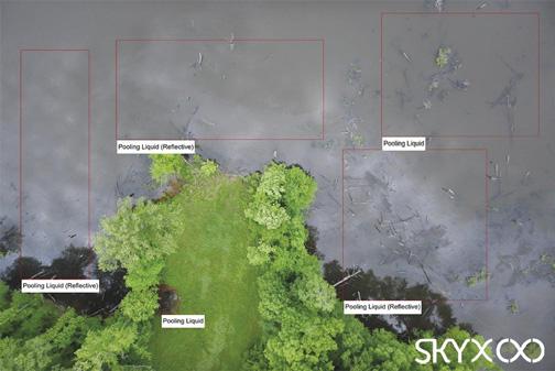
Figure 1. Aerial photo of pipeline showing areas of pooling liquid and reflective pooling liquid which could indicate an oil spill.
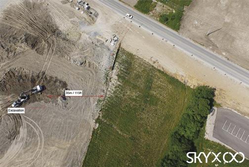
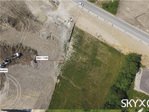
Figure 2. Aerial photo of pipeline showing third-party activity, excavation.
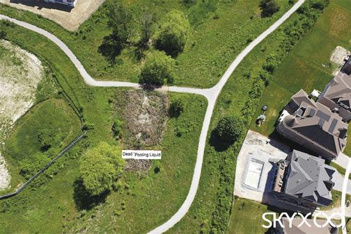
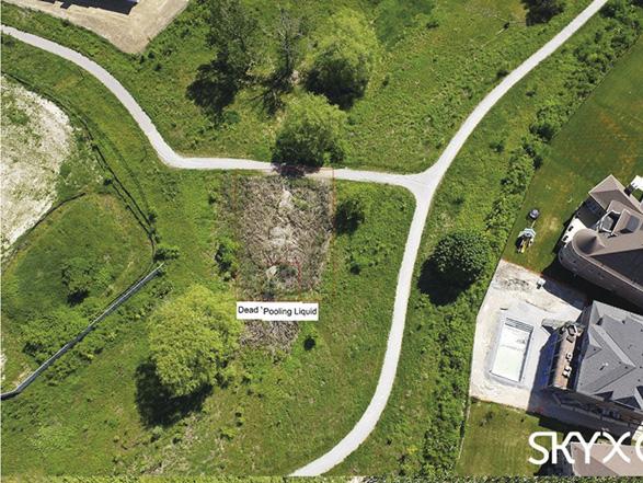
Figure 3. Aerial photo of pipeline showing areas of dead vegetation and pooling liquid that could signal an underground pipeline leak. Detect common midstream pipeline hazards early There are many midstream pipeline hazards that can be detected early using aerial data acquired by UAVs. Here’s how it can help you prevent four of the most common hazards.
1. Pipeline failures, leaks and spills UAVs are able to source imagery with incredible spatial resolution and accuracy, and from these images, a multicategory anomaly detector can spot the signs of a failure. These include pools of oil, gas plumes, abnormal ground discolouration, dying vegetation, and oil slicks in bodies of water.
All of these anomalies can be spotted via standard RGB imagery, but there are a variety of specialised UAV sensors that can help you be 100% sure. For instance, say there’s a strange-looking patch of ground colouration along your right-of-way (ROW), but you’re not quite sure it’s a spill. With an infrared sensor and its thermal imagery, you can identify specific changes in ground temperature that can verify whether it’s actionable.
2. Unauthorised third-party activity Year-over-year, PHMSA’s Significant Incident Report shows that third-party excavation continues to be one of the most persistent threats to pipeline safety. Why is this? The traditional inline technologies you likely rely on will only notify you after damage has already occurred. You may contract manned aerial inspections for this very reason, but these inspections usually don’t happen with the frequency needed to reliably identify these issues. An aerial data solution using UAVs can bring reliability to your visual monitoring efforts.
3. Environmental health Collecting high quality aerial data on a consistent basis makes vegetation management much more straightforward. With accurate 3D models of vegetation canopies around
your ROW and change detection capabilities, it’s easy to analyse the growth of vegetation from inspection to inspection, and get notified when and where unacceptable levels of encroachment are taking place.
4. Pipeline product theft In recent years, illegal tappers have adopted careful theft methods proven to evade traditional leak detection technologies. Increasingly, illegal tappers are using sophisticated, professional methods to extract product from pipelines virtually undetected. This can be prevented using aerial data, arming you with the intelligence you need to identify, monitor and take action on the hotspots of illegal activity, significantly reducing costs associated with stolen product and theftrelated damage.
Key reasons to adopt ongoing aerial monitoring in 2022 If you’re not already convinced that having access to unique, high-quality aerial data on an ongoing basis could greatly enhance your pipeline integrity, here are five compelling reasons. ) Midstream oil and gas companies are lacking access to reliable and quality data. Current technologies for data capture provide lowquality and inadequate data which often remains disconnected and hard to access without excessive manual effort.
) Technologies for solving the data issue already exist. Layering highquality aerial data over your existing ecosystem provides a holistic view of your entire pipeline infrastructure. This is the best way to solve the data issue currently experienced by many pipeline operators.
) The data captured and analysed by today’s technologies help asset operators shift from reactive to proactive decision making, for better outcomes and higher confidence in decision making.
) Being able to visually assess anomalies using highresolution visual data captured by long-range aerial systems can help reduce the likelihood that inspection crews will be dispatched to potentially dangerous conditions.
) Long-range aerial systems that are equipped to do routine flights and gather data on an ongoing basis inform operators of potential problems before they happen, reducing cost and mitigating risk.


Figure 4. Aerial photo of pipeline showing illegal activity, hot tap.
Trust the experts in long-range aerial pipeline data Once you’ve decided that you’re ready to integrate ongoing aerial monitoring to your pipeline integrity management programme, the next step is to decide whether or not to manage the operation in-house or bring in the experts. It pays to know about the capital investment, staff and training that are part of that commitment. Ongoing systematic aerial pipeline monitoring requires: ) Sourcing, purchasing and operating your fleet of drones. ) Servicing, repairing and maintaining the fleet. ) Training drone pilots and operators. ) Planning and executing flights on a regular basis. ) Managing regulatory compliance and ensuring certifications are always up-to-date.
) Storing and analysing thousands of highresolution images to identify anomalies. Since these requirements fall outside of core competencies, forward-thinking midstream oil and gas companies are engaging expert solution providers like SkyX. The SkyX system is an end-to-end aerial data solution that includes the provisioning of unmanned vehicles, operations, ongoing support, data analysis, and high-impact reports for longrange asset inspection and monitoring. Some of the benefits offered by SkyX include: Detailed change detection At SkyX, we know it’s very difficult for a person on foot or in a truck, or even a pilot in a traditional aircraft to pick up subtle changes that change month-over-month, year-over-year, along a ROW. The SkyX system compares images from previous flights for every single foot the right of way so we know when there is a change. It could be man-made change, like digging near a ROW, or it could be a naturally occurring change like a shift or crack in the ground. Targeted, collaborative approach We work very closely with our customers to identify the areas they’d like to monitor. Then, we come up with a concept of operations of how we’ll fly the unmanned vehicles to capture the data. We work hand-in-hand with the customers’ health, safety and environment (HSE) and security maintenance teams on an ongoing basis. Intuitive system Figure 5. SkyX’s SkyVision software showing area of interest marked as high The aerial data our vehicles acquire gets fed into our priority. proprietary software system, SkyVision. This system processes the images, highlights areas of interest or anomalies and then shows them to the customer on a map in a very intuitive way, making it easy for them to see where the issues are. The customer can then export the data and load it into the system that they use to monitor their assets, whether it’s ArcGIS or another platform. Complete solution What SkyX has brought to the market is a complete solution that includes the hardware to capture the data over long distances and the software system that converts all of that data to actionable insights. By flying unmanned vehicles on a regular basis and comparing data over time, we identify potential issues that would often go undetected. Start the aerial data conversation Now is the time to start the conversation about adding a new layer of data to your pipeline integrity programme. Changing to a more proactive pipeline monitoring method will not only protect the health of your aging asset, but also protect people and the planet today and in the future.