INTRODUCTION
In India , as elsewhere, urban edges are often positioned in a developmentalist framework, which assumes a preexisting rural is in transition towards something that inevitably becomes urban. Recent scholarship has started to question such teleological assumptions and offer more complex renderings of notions of urban edges. This book takes up this challenge. In doing so, it pushes back on practices and assumptions that insist on a dichotomous reading of an idealized urban in relation to an idealized periurban, like developed versus undeveloped, complete versus incomplete, or privileged versus disenfranchised. Instead, this book argues that hybrid urban-rural conditions, and urban edges more generally, are best thought of as emplaced.
The book is an up-close study of a one-kilometer-square area of periurban Kolkata, in Gangetic West Bengal, India.1 Specifically, it focuses on periurbanization in southwest Kolkata through an in-depth study of a settlement area in Maheshtala Municipality. This study area sample was selected precisely because of the absence of spectacular or unusually rapid change: there are no megaprojects here, no stories of sudden eviction. In the absence of that type of change there is, nevertheless, the emergence of a particular “kind of urban” condition, remarkable in its characteristic of slow urban-rural hybridization.
Many parts of Gangetic West Bengal, as with Monsoon Asia more broadly, encompass built landscapes created from dense interactions between humans, nonhumans, and their diverse agencies. The current periurbanization processes both rupture and confirm those preexisting logics in spatially and ecologically diverse ways. For instance, the households and institutions in the case study area are embedded in an incrementally changing context that is neither fully rural nor fully urban. For them, the transition from a rural to a post-rural condition has taken a lifetime and encompasses a range of simultaneous changes across a number of generations. The book describes and accounts for the dimensions of these processes through the lenses of governance, livelihoods, ecologies, and infrastructure.
9
Additionally, the book takes a radically literal approach to emplaced scholarship of contemporary settlement conditions. The assumption that urban edges are not much more than “becoming urban” is stitched into place by normative thinking about where and how transcendent urban theory and good urban practice emerge. Core principles of urbanization often derive from Global North experiences. This book participates in thinking anew about such assumptions. Geographer Jennifer Robinson (2002) maintains that cities in the Global South have long been rendered “off the map” of widely circulating approaches to contemporary urbanization. In response, I purposefully shift attention from the “almost urban” toward a larger, collective, and comparative project of learning from multifaceted “kinds of urban.” The book is offering more than just another instance, another isolated case study. It is a situated contribution toward a newly invigorated urban comparativism. As geographer Jane M. Jacobs (2012) reasons, complex, emplaced renderings of urbanization are needed for comparativism to be meaningful.
While it is important to engage the term periurban, it is also necessary to move away from it. I engage the sense of uncertainty that an urban transition implies and delve into “actual socio-spatial and political ecological processes by which specific forms of urbanism come into being,” including the periurban (Friedmann, 2016, p. 163). I do so to better understand the logics and consequences of such conditions, with the ultimate goal of better understanding situated future possibilities. This includes better understanding a range of intersecting questions, including: Are there distinct, “place-specific” periurban phenomena that generate their own dynamics, including dynamics specific to Asia (Friedmann, 2016)? And, thinking specifically about India, to what extent are the urban and the agrarian “co-produced” (Gururani & Dasgupta, 2018) in such edge conditions? The book contributes to this body of scholarship. Central to grasping the temporal and spatial aspects of change and transformation in the case study area is a methodological commitment to the visualization of process.
Rural and Urban in India
The terms urban and rural are social constructs as much as they are lived experiences or land uses. They are categories that are used politically, and this political framing of the rural and the urban is an important context for understanding the transitional assumptions behind the concept of periurbanization, both generally and in India specifically (Leaf, 2016; Shatkin, 2016). As Friedmann (2016, p. 163) notes of India, it is a nation in “catch-up”
10 Introduction
with respect to urbanization, with the central government deliberately aiming (as policy) to have 50 percent of the population living in cities by 2050. Becoming urban, however, requires massive quantities of land suitable for construction and the obstacle in the way is that most of this land is already dedicated to other uses. In India most land is dedicated to other, nonurban uses: “a variety of human settlements, from indigenous villages to the tens of thousands of ‘irregular’ settlements that dot the periurban landscape, as well as smaller urban centers and farming communities” (Friedmann, 2016, p. 163).
At the same time, India has compelling examples of rapidly growing megacities, with populations of over ten million people. It currently has five such cities (New Delhi, Mumbai, Kolkata, Bengaluru, and Chennai) and is projected to have seven by 2030, with the addition of Hyderabad and Ahmedabad (UN Habitat, 2016). In most instances, these Indian megacities incorporate the densely settled, rural-urban, “metropolitan” periphery, and these extended metropolitan regions are, in part, products of changing statelevel definitions of the urban. Such urban regions are often “urban” only by categorization for the purpose of the Census, but do not have the appropriate policy, administrative, or finance structures. Any effective plan-making for such extended “metropolitan” regions is either missing or ineffective (Ahluwalia, 2019, p. 86; see Sivaramakrishnan, 2015). The part of Gangetic West Bengal/Kolkata that forms the focus of this study is an illustrative example of a rural-urban condition that has been nominally designated and imaginatively envisioned as “urban”, and so incorporated into the development framework of the extended Kolkata Metropolitan Area.
Yet this new emphasis on the urban rests on a longer history in which there has been a political bias in favor of the rural sector, at the expense of the urban. For example, the urban population is underrepresented in both national and state legislatures, and until recently there has been an assumption that “urban areas can take care of themselves” (Ahluwalia 2019, p. 86). Such assumptions no longer hold in India, and this is manifest in both political and infrastructure development reforms that have, with various degrees of success, placed new emphasis on the urban. The most pertinent political reform relates to the Constitution of India which, through a commitment to decentralization, now places the responsibility for urban governance on poorly prepared substate local bodies, like Maheshtala Municipality, creating an enduring problem that is still not rectified. The most pertinent economic and infrastructural reform was the launch of the Jawaharlal Nehru National Urban Renewal Mission (JnNURM) in December 2005, and further targeted, “mission-mode” initiatives that aimed to support both sustainable urban development and the “urban growth machine” (Molotch, 1976).
11
Turning first to the political reform of decentralization: the 74th Constitutional Amendment, enacted in 1992, brought in a commitment to decentralization of governance, and as part of this there was formal recognition of urban local bodies as the “third tier” of government in India (Ahluwalia, 2019, p. 84). Under its 12th Schedule, the Amendment mandated that state-level governments transfer to local-level governments a set of specified functions, including town planning functions such as the regulation of land use and infrastructure construction (buildings, roads, and bridges), as well as public health functions, such as the provision of water, sanitation, and solid waste management. Although such responsibilities now rest with urban local bodies, this is not backed by either adequate finances or local capacity in planning and management. Many urban local bodies are in a quandary, as they are unable to deliver the services to residents that are their constitutional responsibility. Maheshtala Municipality, as a formerly rural area that switched to urban local governance in 1993, immediately after the 74th Constitutional Amendment was formally recognized, manifests an explicitly developmentalist version of this troubled condition, wherein becoming urban is often embraced as an aspiration by political institutions that do not have the capacity to realize that vision.
Turning next to the economic and infrastructure reforms: in 1991—and reversing course from a heavily protected and highly regulated policy regime—the Government of India, like many other countries in Asia, launched a process of wide-ranging economic reform. The intention was to create room for market forces and to open the economy to foreign trade and investment (Ahluwalia, 2019, p. 87). Two results of these initiatives relevant to this study are first, the rapid escalation of land prices and the efforts by state governments to capture this value; and second, the initiative of national “missions” for urban renewal, which encouraged urban local bodies to capture the funds and opportunities made possible through these initiatives. Various missions have generated a lot of action on the ground, including preparation of comprehensive City Development Plans, incentivizing private-public partnerships, and the identification and realization of infrastructure and service delivery projects. Urban renewal missions have also encouraged intercity rivalry in India, as different cities vie for recognition for attaining the best progress in various sectors in national government-sponsored competitions (Ahluwalia, 2019, p. 96).
Across India, these fast-track, mission-sponsored infrastructure investments produced “global” projects, reflecting what geographer Eric Shephard et al. term “mainstream global urbanism” (2013, p. 895). A survey of missionsponsored infrastructure investments revealed a preference for “big visions”
12 Introduction
like the construction of large-scale infrastructure projects (Kundu, 2014; Mahadevia, 2011). The impulse to invest in impressive “mega” projects has meant that peripheral urban local bodies, such as Maheshtala Municipality, have not necessarily seen any direct benefit. Instead, as this book will show, mission-sponsored investment is arriving slowly, in fragmented packages that build toward a vision of universal coverage of “basic” services and Sustainable Development Goals.
Yet the municipal authority’s revenues and responsibilities are not matched. The revenue of local urban bodies in India is limited, as it is largely dependent on a single tax—property tax—and the tax itself is not fully collected. In addition, the total “basket of revenues” available to municipal authorities has been described as “narrow, non-buoyant, inflexible, and grossly inadequate” (Mohanty, 2014, p. 130). Nevertheless, in Maheshtala Municipality, much-needed, smaller-scale public services such as street lighting, paved local roads, solid waste management, and the provision of reliable and healthy drinking water are slowly being built. Such infrastructure is being delivered as separate projects, one after the other, and much later than anticipated. As this study shows, the condition of impoverished local urban bodies “muddling through” their service delivery responsibilities is often impacting negatively on the lives and livelihoods of long-term residents, testing the patience of newcomer residents, and contributing to the ruining of the cultivated landscape. At the same time, the condition of impoverished local urban bodies muddling through draws society within the bureaucracy itself, and does so in emplaced ways.
Being Ordinary
The book looks at an ordinary urban local body within an extra-ordinary city and delta region. In what follows, I explain what I mean by the term ordinary, drawing on the notion of the “ordinary city” as called for by geographer Jennifer Robinson (2005). But first, I must explain various territorial boundaries and briefly situate Maheshtala within the expansion of Kolkata over time. Maheshtala Municipality lies on the southwestern edge of Kolkata. It is an urban local body located within the Kolkata Metropolitan Area, but outside of the jurisdiction of the Kolkata Municipal Corporation, which has planning and development responsibility for the core “city” area. In terms of population, Maheshtala Municipality is the largest urban local body of the Kolkata Metropolitan Area, after Kolkata and Howrah.2 This reflects the fact that the planned expansions of metropolitan Kolkata have, until recently,
13
been to the less populated north (in the 1950s), then toward the east and west (since the 1990s), bypassing the historically densely settled southwestern area. Why the southwest has been long settled is a complex of historical and ecological factors. Maheshtala sits, in part, on the levee of the Hooghly River, which is higher ground relative to the surrounds. Since the 1800s, the area has included riverfront industries and port facilities and has been populated by migrant groups seeking refuge following famine, the partition of India and Pakistan, and war. In the words of a local official, “growth” has never been planned toward the south because “we are already urban” (Maheshtala Municipality Officer, personal communication, December 2018). Meaning he didn’t see the need for the southwest to be built up in a planned way, because the area is already densely settled, deeply linked to the city, and long connected to the river and the delta.
Calling the types of changes that do and do not happen in Maheshtala Municipality as “growth” is already assuming something about the development trajectory of the area. By the 1990s, the area may well have been urban in kind, but the formal specification of the Maheshtala Municipality in 1993 offered a framework for planned urban growth in the southwest; albeit growth that is mainly incremental and led by small landholders and entrepreneurs, along with some elite residential high-rise enclaves and related infrastructure development.3 These kinds of periurban changes seen in Maheshtala Municipality stand in stark contrast to contested and politically damaging state-level-led land development projects in the outer western and eastern edges of metropolitan Kolkata, such as Singur, Nandigram, and New Town. Furthermore, not all change is in the direction of increased population density, but is informed by diverse nonhuman agencies, as subsequent chapters will show. When rural local governance is changed by political fiat to urban local governance, it does not mean that irrigation networks, paddy cultivation practices, plantations, and productive home gardens and ponds immediately disappear. Sometimes, such recategorization lags behind public infrastructure provision and livelihood changes, such that it confirms an already-present urban condition. In other areas, it may herald a hopeful transition yet to be realized. The temporality and directionality of such governance change can vary greatly from place to place, and within places. In areas like Maheshtala Municipality, periurbanization is taking place in a jumbled fashion, where areas that are closer to the few main roads are much more congested and connected than (often nearby) areas that are linked by narrow or unsealed roads, lanes, and pathways.
Many of the characteristics of slow, incremental periurban transformation are overlooked, even though stasis and extended temporalities have long been
14 Introduction
noted in relation to agrarian transformation, as small landholders struggle to meet their escalating needs from farming ever smaller landholdings (Rigg et al., 2016, p. 128). Slow, incremental periurban transformation is also vast, in the sense that, when considered collectively, unspectacular rural-urban hybridization is significantly bigger in extent than the type of city created by spectacular “mega” developments (see Sahana et al., 2018). Most importantly, incremental change is lived, and may even be experienced as a slow violation of existing livelihoods or aspired-to lives (Christian & Dowler, 2019; Dillon, 2012). Longtimer and newcomer residents live in this “doubling” for an extended period of time, even a lifetime.
The major conflicts in periurban areas in India are often created by tensions arising from activism by the “new” middle class to exclude others, and this often takes the form of a “bourgeois environmentalism” (Shaw, 2018, p. 106; see Baviskar, 2004). There is, however, an under-studied dimension of periurban middle-class life in India which is the existence of a “peripheralized middle class” (Shaw, 2018, p. 104). Geographer Malini Ranganathan (2011, p. 172) distinguishes between lower middle-class groups who “do not distance themselves from the working-class poor and who are different from the English-speaking middle-class.” In fact, like the poor, Shaw (2018, p. 106) says, the lower middle class also make claims on the state for regularization of their settlements through legal and extralegal means. The one-kilometer-square study area is sited in such a peripheralized middle-class community, which is characterized by many microconflicts where long-timers and newcomers continuously find ways to get by and get along amicably.
Robinson (2005, p. 1) argues that an ordinary-cities approach takes the “world of cities” as its starting point and attends to the diversity and complexity of all cities. Instead of seeing only some cities as the originators for theories of the urban and dividing them up according to levels of development, she argues that “ways of being urban and ways of making new kinds of urban futures are diverse and are the product of the inventiveness of people everywhere” (2005, p. 1). This book is committed to this claim: it also seeks to extend its veracity by thinking beyond a city-scale view toward subcity categories and processes, most notably the category of periurban and the process of rural-urban hybridization everywhere. By starting with periurbanization, this book contributes to scholarship that refuses and decenters city-centrism. This is why I frame the study area as becoming a particular “kind of urban,” one that is not simply defined by being on the edge of Kolkata, or even in the municipality. This ordinary, area is also located in ecologically defined territories such as Gangetic West Bengal and the Ganges Brahmaputra Meghna Delta. As will be clear, the monsoon
15
and delta context influences power and agency in the study area, just as the municipal and local bodies exert juridical and planning power, but they do not define it.
Maheshtala Municipality, like other newly formed urban local bodies of India, is simultaneously newly empowered by the 74th Constitutional Amendment and profoundly disempowered. Yet Maheshtala Municipality, manages to make things happen and “muddle through.” Planning, regulation, and financial management happens, despite shortfalls in capacity and routine procedural detours. Planner Neha Sami (2017, p. 107) talks of the way in which urban governance by such newly formed, urban local bodies is attained through “learning by doing.” In the context of her study in Bangalore, this local learning happened in conversation with arriving experts and through procurement partnerships, a process noted in other Indian cities (see Ghertner, 2011, 2017; Weinstein et al., 2014). In ordinary Maheshtala Municipality there is nothing of a scale or cost from which to garner such external expertise, or to incentivize a model of private-public urban planning and development.
The muddling through evident in the study area is not “planning failure.” As planner Ananya Roy (2009) notes, planning failure in the Indian urban context is often characterized by three explanations. The first is the narrative of the chaotic Third World megacity that defies all planning controls and forecasts. The second is the explanation that places the onus of fault on incompetent Indian planners who consistently underestimate infrastructure and service needs. The third is the explanation that blames failure on the forces of neoliberal capitalism and unchecked liberalization. Roy offers an alternate reasoning for why Indian cities cannot plan, which is to argue that India’s mode of planning is poorly understood. She redefines it as an “informalized entity” that proceeds through systems of deregulation, unmapping, and exceptionalism (2009, p. 86). She says, “these systems are neither anomalous nor irrational; rather they embody a distinctive form of rationality that underwrites a frontier of metropolitan expansion” (2009, p. 86). My study avoids the romanticism evident in Roy’s alternative typology but I do draw on the idea of alternative rationalities. I argue that the local culture of governance in my study area confirms the presence of an alternative, informal state rationality, and that this rationality is grounded in “learning by doing” in a context that is undeniably framed by neoliberalization of development, and most notably the pressure on underresourced local urban bodies to capitalize on the opportunities of urban-like development.
16 Introduction
The Study Area
In this section I offer a concise historical and statistical account of the study area with relevant contextual details about urban local governance.4 Maheshtala Municipality, in the district of South 24 Parganas, was formally constituted on December 21, 1993 (West Bengal Legislative Assembly [WBLA], 2016, p. viii). It was previously self-governed by an assortment of panchayati raj (village rule) institutions, including twenty-one gram panchayats (village councils) and forty partial and total mouzas (rural administrative districts) (2016, p. viii).5 The area was settled long before British colonization, however it is said that the area was named “Maheshtala” for Shri Mahesh Suri, who was given the role of lambadar (land-tax collector) by Shri Ramkanta Banerji, a local zamindar (landholder) who had been nominated by Lord Clive, the governor of Bengal Province under the East India Company (WBLA 2016, p. viii). Relative to surrounding areas, Maheshtala’s municipal status arrived late. For instance, the two municipalities bordering Maheshtala were designated earlier, as they were anchored in colonial trading towns within long-settled bazaar towns, centers of learning, and ports. Budge-Budge Municipality, which is on the Hooghly River and directly to the south of Maheshtala, was established as a municipality as early as 1900 (Bureau of Applied Economics and Statistics, 2009). Similarly, Rajpur-Sonarpur, located nearby on the Adi-Ganga (the old main channel of the Ganges) toward the east of Maheshtala, was established as a municipality in 1876.
For Maheshtala to be designated as a municipality it had to meet three criteria, as outlined in the West Bengal Municipal Act 1993 (Government of West Bengal, 2017, p. 14). First, it had to contain a population of “not less than 30,000 inhabitants.” Second, it had to have a population density of “not less than 750 inhabitants per square kilometer.” Finally, it had to have an “occupational pattern in which more than 50% of the adult population [were] chiefly engaged in pursuits other than agriculture.” By the time it gained its municipal status, Maheshtala exceeded all these measures significantly. In 1991 the total population was 211,352 inhabitants, the “urban” population was 83 percent, and the “rural” population was 17 percent (Bureau of Applied Economics and Statistics, 2009). By 2001 the entire population of Maheshtala—385,266 inhabitants—was categorized as “urban” (Census Organization of India, 2001). Across a municipal area of 42 square kilometers, the population density of Maheshtala was 9,260 people per square kilometer in 2001. As noted earlier, Maheshtala’s population density and urbanity is derived from colonial and post-independence industry. The riverfront is comprised of large factories, and the main artery road, Budge-Budge Trunk Road, continues to be lined
17
with small and medium enterprises. In addition, clothing manufacturers, the nearby Port of Kolkata at Khidirpur, and the industrial area of Taratala have been longtime employment centers for the residents of Maheshtala. The main occupational pattern of the area is described by the state-level government as “non-agricultural,” and the recognized occupations are tailoring, leather works, fireworks, and “a major workforce of unorganized sectors” (West Bengal Legislative Assembly, 2016, p. 1).
As noted earlier in this introductory chapter, being classified as urban or rural in India is a politically motivated nominal and statistical outcome. Although Maheshtala displayed various signs of urbanity in 1993, the 2001 Census also shows that some agricultural cultivation persisted in the area, as evidenced in a close reading of the various categories of “non” or “other” workers. In 2001, of a total of 385,266 inhabitants, some 265,612 (68.9%) were categorized as nonworkers, most likely home-based women but also possibly informal cultivators. Some 119,654 (31.1%) inhabitants were classified as workers, most likely men, with 358 (0.3%) of this worker category described as cultivators and 417 (0.4%) as agricultural laborers (2009; 2001). Some 11,619 (9.7%) inhabitants were described as household or industrial workers, and 107,260 (89.6%) were classified as “other” types of workers.
Maheshtala was also included in the animal census in 2003, which indicated that there were some 3,645 cattle, 1,909 buffalo, 106 sheep, 935 goats, 4,781 pigs, 2,302 dogs, 51,081 poultry birds, as well as 1,006 persons engaged in fishery (Directorate of Animal Resources and Animal Health, 2003). In Ward 13, the specific case study site, there were 308 cattle, 24 buffalo, 0 sheep, 18 goats, 104 dogs, 3,727 poultry birds, as well as 53 persons engaged in fishery in 2001. With an area of 3.12 square kilometers, Ward 13 is the largest ward of the thirty-five wards that comprise the municipality (total area 44.18 square kilometers) and it is the third most populated with a total of 18,829 persons (Maheshtala Municipality, 2015). While the Ward is located adjacent to the southwestern boundary of the Kolkata Municipal Corporation, or “the city,” the density of Ward 13 is 6,034 person per square kilometer, which is less than the average of 10,172 person per square kilometer in the municipality.
What this brief historical and statistical account of the case study area offers is a glimpse into its characteristics of slow urban-rural hybridization. What this account also offers is a reminder of the need to move beyond a dichotomous reading of rural and urban, even if planning and census taking insist on reproducing such terms. To undertake this rethinking, I draw inspiration from urban political ecology, which is an established field of scholarship that seeks to analyze emergent socio-spatial formations and their political-ecological effects. In particular, I draw on a subset thread
18 Introduction
of urban political ecology scholarship that emphasizes the value of being situated (Lawhon et al., 2014). In the periurban area at the heart of this study nonhumans and their diverse agencies are entangled with society, in situ ecologically, via event-linked situations, and through enduring situated institutional and infrastructural formations. It is thus appropriate to place this study in the broader field of relevant scholarship. That scholarship comprises, firstly, work on periurbanization, both within urban geography and wider urban studies, which I address in chapter 8. Secondly, it comprises urban political ecological and related scholarship that helps to break the binary and teleological assumptions linked to understanding periurbanization, by further deconstructing categories such as rural and urban, society and ecology, as well as human and nonhuman agency. It is this scholarship on urban political ecology that I turn to next.
Parsing Urban Political Ecology
Urban political ecology focuses on unsettling traditional understandings of “cities” as ontological entities separate from “nature,” and on how the production of settlements is metabolically linked with humans, nonhumans, and their diverse agencies, like flows of capital (Tzaninis et al., 2020). The approach is central to this study, however not all parts of the field apply evenly. I am selective in how I engage the urban political ecology, which is itself not settled or formalized. In what follows, I parse the field, and in the final section of this chapter I show how the approach informs the organization of the book. In short, I retain the core concept of “metabolism” while advancing emerging concepts about the agency of nonhumans in the context of the unique histories and trajectories of Southern urbanism. I use the term nonhuman agencies in a broad way, encompassing institutions with their official documents and reports, infrastructural and architectural legacies, as well as the forceful agencies of heat, humidity, wind, water, vegetative decay and growth, and the life of animals.
Metabolism
As argued by geographers Erik Swyngedouw and Maria Kaika (2014), the field of urban political ecology emerged in response to late twentiethcentury urban theory and practice, which was “strangely silent” about nature. They observe that urban thought at that time said little about the “socionatures” that underpinned capitalist urbanization processes or about how urbanization processes produced increasingly problematic environmental
19
conditions (2014, p. 464). The field of urban political ecology, they say, also emerged in the Northern context of the increased deterioration of the environment in the 1970s, the “specter of immanent scarcity in nature,” and environmental movements that propelled environmental matters to the top of the urban policy agenda (2014, p. 465). In response to this silence about a troubled nature, Swyngedouw (1996, p. 69) developed a “new language,” which was soon recognized as a productive analytical approach for understanding society and nature (Heynen et al., 2006; Swyngedouw, 2006). Swyngedouw revisited nineteenth-century Marxian social theory, which addressed nature in a historical-materialist and dialectical ontology, and he combined this with work on “cyborgs” (Haraway, 1991) and “quasi-objects” (Latour, 1993). The concept of “metabolism” developed by Swygedouw was the analytical “entry-point” for theorizing and analyzing “socio-natural things” (2006, p. 106; also see Keil & Boudreau, 2006). Since then, the field of urban political ecology has emerged as a rapidly expanding body of thought in nature-society scholarship and the dimensions of this continue to be well documented (Collard et al., 2018; Heynen, 2013, 2016, 2018; Keil, 2003, 2005; Zimmer, 2010).6
Environmental sociologist Jason Moore (2017, p. 286), has argued that metabolism “has become a plastic category that can be molded to serve diverse analytical objectives.” Nonetheless, it has become especially useful to Marxian-inspired scholars who seek to understand the “rupture” in the interaction between humanity and “the rest of nature” that has resulted from capitalist production (Foster, 1999). Metabolist thinking has helped move conceptualization away from the dualism of Humanity and Nature to the dialectics of humanity-in-nature (Moore, 2017, p. 288). Geographer Matthew Gandy (2004, p. 364) argues that the metabolist “dialectical” is especially relevant to urban environments, noting that it points to:
a mutually constitutive conception of relations between nature and culture in urban space: nature is not conceived as an external blueprint or template but as an integral dimension to the urban process, which is itself transformed in the process to produce a hybridized and historically contingent interaction between social and bio-physical systems.
“Hybridity” is also emphasized by Swyngedouw (1996, p. 69) who conceptualized socio-natural things as hybrids (subjects and objects, material and discursive, natural and social) “from the very beginning.” He says, central to dialectical metabolism is to recognize the social, cultural, and political power of socio-natural relations, and to understand such relations
20 Introduction
as “techno-natural imbroglios” (Swyngedouw, 2006, p. 113). In thinking through metabolism, Swyngedouw and Kaika’s (2014, p. 459) concern is not with the presence of nature in the city but, as they put it, the urbanization of nature, “the process through which all forms of nature are socially mobilized, economically incorporated and physically metabolized/transformed in order to support the urbanization process.” In this sense, their interest in “imbroglios” is much more than coincident assemblages or entanglements of social and natural elements, it is invested in understanding a socio-spatial process whose functions are predicated upon ever longer, often globally structured, socio-ecological metabolic flows that not only fuse objects, nature and people together, but do so in socially, ecologically and geographically articulated, but depressingly uneven, manners (2014, p. 462). Historical-geographical insights into these ever-changing configurations are thus necessary for the sake of considering future political-ecological urban strategies (Swyngedouw and Heynen 2003, p. 898). While my research does not adopt a specifically historical-materialist perspective, it does delve into the agency of documents and socio-spatial processes. Such situated geography is highly localized, often being formed amidst policies and aspirations created in comparison with other cities.
Nonhuman Agency
Metabolism is an urban political ecology idea that aims to conceptually consider nature in society. However, this is not always well realized. Geographer Noel Castree (2002, p. 131) argues that much urban political ecology “erases nature altogether in the guise of making non-dualistic theoretical space for it.” Castree (2002, p. 131), who positions himself as writing from a “nonorthodox Marxist perspective,” argues that Marxian-inspired urban political ecology often bestows on capitalism “all the power in the society-nature relation,” such that nature is always ultimately assumed to be outside and subject to the exploitations, constructions, and manipulations of capitalism. Concurring, geographer Bruce Braun (2008, p. 668) suggests that the concept of metabolism can actually “reinstate a separation between nature and society” because it retains “the economy” as a pre-given ontological category.
It is in part this problem that led urban political ecology to engage with actor network and vitalist perspectives that more emphatically emphasize nonhumans and their diverse agencies. The work of Sarah Whatmore (2002, p. 4) was an early lead in this respect, drawing both on concepts of hybridity in actor network theory and feminist science studies “to accommodate nonhumans in the fabric of the social” and “redistribute … agency.” For example, Paul Robbins’s (2007, p. 13) pertinent study Lawn People accounts
21
for the interaction between suburban lawns and suburban people. It offers an urban political ecology that sees the lawn not as an “ecological product” of human action, but as an “environmental actor” that forces behaviors and adjustments in individuals and institutions. As he notes, “The rhythms and behaviors of these neighborhoods, although enforced by human communities, are dictated by the pattern, pace, and specific ecological needs of other species” (2007, p. 116). The present study does not engage directly with these epistemological debates, but it does emphasize the need to think about capital, humans, nonhumans, and their diverse agencies altogether. Furthermore, the study remains inspired by Whatmore’s commitment to “the spatialities of everyday life” and how these “constitute a mode of dwelling in the world.” Accordingly, this study seeks to better understand periurban “nature-culture hybrids” and how “their interferences [are] resisted and accommodated in the intimate fabric of social life” (Whatmore, 2002, p. 5; see also Ingold, 1995; Thrift, 1996).
There are a range of nondualistic approaches that emphasize the liveliness of nonhumans and their agencies. Post-human or “more-than-human” geographies (Whatmore, 2002, 2006) include relational approaches (see Haraway, 1991; Latour, 1993; Massey, 2004)7 and vitalist approaches (see Deleuze & Guattari, 1988). Importantly, post-human ontologies are distinct from the dialectical ontology of metabolism. According to Castree (2002, p. 121), a “relational” ontology is a view of the world where the liveliness of nonhuman agencies is considered on equal status with humans—they are “co-constitutive.” Similarly, a “vitalist” ontology brings a focus on life as an “immanent, vital, and emergent force” (Wylie, 2007, p. 202). Relational and vitalist ontologies are often described as conceptually “flat” or nonhierarchical, and they break the dualist habit of thinking that determines either nature or society/capital to be structuring agents.
A flat ontology such as this offers the possiblity for symmetrical agency. So, while Marxian-inspired metabolist thinking can ultimately erase nature in pursuit of its critical perspective on capitalism and uneven development, post-human approaches open out to a diverse field of liveliness and agency. While not directly political, such approaches are productive in their potentiality. For example, consider “multispecies studies,” which aim to think about sociability within “socio-natures.” As outlined by anthropologists Eben Kirksey and Stephan Helmreich (2010), multispecies studies bring forward “creatures previously appearing on the margins of anthropology—as part of the landscape, as food for humans, as symbols,” and show that they have “legibly biographical and political lives” (2010, p. 545). Multispecies studies reveal that it is possible to put nature in
22 Introduction
society without erasing the notion of nature as something that changes of its own accord (see also de la Bellacasa, 2017; Haraway, 2016; Tsing, 2014).8 Another example, and one that I engage later in this study, is work on the agency of paper documents, like maps. Anthropologist Matthew Hull (2012, p. 21) argues that documents, or what he terms “graphic artefacts,” build associations. They do this through circulation and recontextualization of the graphic artefacts themselves, and through human “involvement in the enactment of the objects [the graphic artefacts] talk about” (2013, p 25).
In sum, Marxian-linked metabolist thinking is a dialectical ontology that has usefully offered a framework for examining society and nature as entangled. However, its explanatory default can still privilege the determining agency of capitalist processes, ultimately pacifying nonhumans and their diverse agencies. Post-human approaches, in contrast, bring nonhuman agencies and social action together through relational and vitalist ontologies, although there can be some loss of explicit political dimensions. In this study, I do not overly commit to one position or the other. There is a place for metabolist thinking as proposed by Swyngedouw and others, particularly when the uneven nature of development is starkly evident. However, my interest in ordinary, periurban conditions that are shaped amidst the graphic artefacts of bureaucratic institutions and a monsoon and delta environment, reveals the need to see diverse nonhuman agencies as powerful. Similar approaches have been pursued by those advocating a “situated” urban political ecology, something that is especially pertinent to conditions of urbanization in the Global South. It is to this special notion of urban political ecology that I now turn.
Southern Urbanism
There have been a number of calls for urban political ecology scholarship to more fully account for the diversity of forms and contexts of urbanism globally. Geographer Yaffa Truelove (2016, p. 4), for example, argues that a “situated” approach to urban political ecology can better account for a range of distinctions, including the unique histories and trajectories of urbanism in Southern cities (Lawhon et al., 2014; Silver, 2016; Zimmer, 2010); the diversity of intra-urban environments in any one city (McFarlane et al., 2017); as well as the diversity across city dwellers in terms of everyday practices and politics (Birkenholtz, 2010; Graham & McFarlane, 2014; Loftus, 2012; Truelove, 2011). Similarly, geographer Mary Lawhon, et al. (2014) aspire to “provincialize” urban political ecology. They show that, for example, African urban political ecologies can inform wider theoretical conceptualizations, thereby influencing associated research methods and policy practice (2014, p. 497). This approach
23
aligns with my interest in shifting the focus from seeing periurban areas as not just “becoming urban” but as emplaced, “kinds of urban.”
Lawhon et al. (2014, p. 497) suggest that a situated, urban political ecology should start with everyday practices, be attuned to discerning diffuse forms of power, and open the way for a politics of change based on practices of “radical incrementalism.” These analytical steps resonate with conditions and possibilities in periurban Gangetic West Bengal/Kolkata and directly inform the way that I have staged urban political ecology in this study.
First, Lawhon et al. (2014, p. 506) observe that there has been a tendency in urban political ecology scholarship to overly link metabolist ideas of “techno-natural imbroglios” to formal infrastructure. However, this does not translate smoothly to ordinary periurban contexts in the Global South where there is a relative paucity of formal or “basic” infrastructure. In such contexts, to focus on modern infrastructure development, for example, can provide only a partial understanding of urbanization. Indeed, the technonatural imbroglios of water, energy, and waste (and even transport, housing, and broadband), in the Global North are very different from those in the Global South, where there is extreme poverty and extensive informality (see Bhan, 2019; Derickson, 2014; McFarlane et al., 2017; Ranganathan, 2014; Roy, 2009; Simone, 2004; Zimmer, 2010). Inspired by Simone’s (2004) idea of people as infrastructure, Lawhon et al. (2014, p. 506) argue that it is better to recognize “people as the central means through which materials flow in many cities” of the Global South. On this basis, they argue for an “epistemological reorientation” in urban political ecology more generally, as seen in the second and third analytical steps.
Second, a situated, urban political ecology begins with a conception of power as diffuse and relational. Building on feminist critiques of urban political ecology (Rocheleau et al., 2013; Truelove, 2011), Lawhon et al. (2014, p. 508) call attention to the limitations of understanding power as created and operating primarily through the process of capital accumulation and class relations. In response, they suggest the need to “reformulate our understanding of power as relationally constructed and enacted.” They operationalize an understanding of power that includes other social categories besides class, such as race and gender, as well as discursive power and associated knowledge claims. This approach has much in common with the work of geographer John Allen (2016; 2010) who argues, in relation to everyday governance, that power has a newfound “reach.” Allen questions the idea that power is simply extended across a given territory or network, and that it is something only related to institutional size and organizational capacity. Instead, he (2016, p. 43) focuses on the way that power as a practical
24 Introduction
tool is mutable, and thus can be practiced in many ways while remaining the same (2016, p. 61). In this study I look closely at “quieter registers” of power, as well as diffuse power as expressed in everyday life as suggested by the feminist critiques noted above.
Third, a situated, urban political ecology makes the connection between theory and practice explicit. Lawhon et al. (2014, p. 502) observe that neo-Marxian recommendations for change largely “fail to respond” to the radical or revolutionary provocation of their arguments (see Swyngedouw, 2018). In response, they argue for a more multifaceted approach for progressive change “rooted in the realities and possibilities of everyday urban practices” (2014, p. 510). This is because, as they put it, “the everyday opens up new spaces through which to derive alternatives for understanding and creating change” (2014, p. 510). For instance, learning from the work of sociologist Edgar Pieterse (2008), they observe how everyday practices can be a foundation and impetus for effecting incremental change, especially in contexts where formal mechanisms are weak, nonexistent, or partisan (Lawhon et al., 2014, p. 511). Others have called this “recursive empowerment” (Ernstson et al., 2014; Silver, 2014). For instance, Simone (2014, p. 36), in describing what he calls the “urban majority of the ordinary” asks:
If residents once made significant accomplishments in building districts that worked for them, then what now? How are their practices of autoconstruction related to the unwillingness or inability of municipal institutions to conduct basic planning and delivery of services, which only dedicated institutions with clear authority and capacity can do at the scale necessary? What has to be considered in order for these accomplishments not to exist as mere relics or shadows of themselves, but constitute a source of influence on subsequent events? What kind of institutional assumptions are prevalent about who residents are and what they can reasonably or legitimately do? What does urban policy attempt to do as an instrument of relating to the residents of the city?
Consistent with this ethos, the research reported upon in this study draws on thick description of everyday life and diffuse power in periurban Gangetic West Bengal/Kolkata. It does so in the hope of enriching our understanding of incremental modes of political empowerment and the futures they make. My intention is to not just communicate the transformations at work in creating a particular “kind of urban,” but also to point to connections that make us rethink the ways in which change happens. I offer the cartographic practice created in this study as yet another
25
circulation of the many documents that I analyze. Furthermore, the study makes a conceptual contribution to periurban scholarship through an urban political ecology approach. This study is not simply a look at a novel and singular periurban condition in and of itself but uses that singularity to better understand periurbanism generally and urban political ecologies particularly. The review of the current scholarship in urban political ecology reminds us of some of the enduring tensions in this field around the conceptualizations of socio-natures, agency, and practice. The urban political ecology approach that I have outlined here offers a way of moving past some of these tensions.
Book Outline
In chapter 1, I begin with urban policy and the search for an appropriate mode of planning by the national Government of India. To do this, I succinctly review the urban reform initiatives that have been launched since the 1990s. I bring a special focus on the 74th Constitutional Amendment for empowering local government and the “mission-mode” projects focused on urban infrastructure. I show how, despite the agenda to empower local government, the central and state governments continue to retain power at the local level, albeit in new ways.
Chapter 1 then shifts to an account of the urban policy and planning initiatives of the State of West Bengal. By way of official visualization strategies, I illustrate how periurban Kolkata has been rendered since the 1990s. I present a close reading of three metropolitan planning documents: the 2011 Perspective Plan; the 2025 Vision Plan; and the 2030 State Plan. The first two plans focus on spatial planning, that is, the planning of “centers” and connective infrastructure. In these earlier plans, the study area is rendered blank, neither being a major center, nor a beneficiary of major infrastructure. The later plan abandons spatial planning altogether, opting for an indicator mode of governance . In this indicator mode, the effects of growth can be read in a digital interface and modulated indefinitely, according to up-tothe-minute urban reform initiatives. What I demonstrate is that situated spatial needs and distinct futures of periurban municipalities do not register on such official maps.
In chapter 2 I situate local-level policy and planning initiatives since the 1980s, revealing the imperfect realization of urban-linked development aspirations. In this chapter, I explain the land use and spatial layout of the municipality and I visualize how Maheshtala was rendered as a “city in the
26 Introduction
making” in its local development plans. The chapter also offers a brief overview of party politics, an important factor in the local governance cultures of West Bengal.
In chapter 3 I seek to speak back to the many assumptions (about, for example, land, livelihoods, and development trajectories) of the official visualizations discussed in chapters 2 and 3. I do so by generating alternative visual materials that are built from the experiences of residents and from my observational work as a researcher in the field. The visual logic of my methodology spans all phases of the research process, from using visual assessments of land cover and land use to select the case study area, through to the analysis and presentation of findings.
Chapters 4, 5, 6, and 7 are linked, as all three chapters are focused on lived accounts of periurban transformations in the one-kilometer-square study area, in Ward 13, Maheshtala Municipality. In chapter 5, I also look back further in time and highlight the characteristics of the long-settledrural through a close reading of colonial maps and reports of Gangetic West Bengal from the 1800s to the mid-1900s. In particular, I look at colonial “drainage works” projects, and the colonial project of establishing cultivated and uncultivated land. In all instances, I map the one-kilometer-square study area into various visualizations, modern and colonial. What I reveal are the ways that big spatial ideas, like the colonial “permanent settlement,” have been built upon, and have shaped, the settled-rural of Gangetic West Bengal.
In chapter 4, I begin what I term “re-rendering” Ward 13, and I introduce the first of three techniques for recognizing the study area anew. I describe the elements and characteristics of drainage and fields in chapter 4, jungle and land in chapter 5, “village” property in chapter 6, and the “urban” land market in chapter 7. That is, I first look at preexisting, periurban infrastructures of tree-lined garden ponds and plantations along with an interlinked waterway and canal system. I then look at the emergence of newly built settlement colonies and a land market amidst preexisting, but now “jungly” rice paddies. The presentation of perspectives on these imbroglios is in chronological order, however, they should also be thought of as occurring simultaneously.
Overall, the empirical chapters (4-7) seek to unfold, or disentangle, how changes were made and the forces which are at work to either diminish or consolidate their presence. I show how the periurban is a condition that is uniquely realized in the context of Gangetic West Bengal specifically, and Monsoon Asia more generally. In chapter 8, I step back and reflect upon the case study in relation to scholarship on periurbanization over time and from India. I argue that the book is a contribution to work being done on urban
27
theory-building from elsewhere than the Global North, specifically from Asia and periurban Gangetic West Bengal/Kolkata. Lastly, the concluding chapter reflects on what this instance of emplaced periurbanization has to say to wider studies about nonhuman agency, territory, and cartographic practice.
28 Introduction
Endnotes
1 Following Friedmann (2016) I use periurban, rather than peri-urban.
2 Maheshtala Municipality has the third-highest population in the Kolkata Metropolitan Area (448,317) after Kolkata (4,496,694) and Howrah (1,077,075) Municipal Corporations (Census Organization of India, 2011).
3 Growth towards the southeast of the Kolkata Metropolitan Area is similarly incremental and led by small landholders and entrepreneurs, however, it has been enhanced by the construction of a bypass and the in-progress relocation of the South 24 Parganas district governance headquarters from Alipur to Baruipur.
4 The study is an in-depth look at a one-kilometer-square area within Ward 13, of Maheshtala Municipality, the reasoning for this dimension and its location is defined in detail in chapter 2.
5 With the founding of Maheshtala Municipality, the twenty-one gram panchayats and forty partial and total mouzas were reassigned into thirty-five wards. Maheshtala Municipality is designated as an “urban local body,” a term I use throughout this chapter, and as interchangeable with the term “municipality.”
6 A narrow critique of urban political ecology argues that it is failing to live up to its promise of constructively examining urbanization as a global process because the city remains central. Geographers Hillary Angelo and David Wachsmuth (2015, p. 16) argue that urban political ecology has “become bogged down in methodological cityism––an overwhelming analytical and empirical focus on the traditional city to the exclusion of other aspects of contemporary urbanization processes.” Recently, this assessment of “methodological cityism” has been refuted by geographer Creighton Connolly (2018, p. 63), who points out that urban political ecology has always moved beyond the city to consider “the various metabolisms and circulations of humans and non-humans connecting cities with places outside of their borders at a variety of scales.” The metabolisms Connolly (2018, p. 69) offers as examples of this claim are: rural-urban metabolisms; landscape; urban agriculture; work on eco and smart cities; and infrastructure. This book, which looks at the metabolism of periurbanization in Gangetic West Bengal/Kolkata, thus aligns within Connolly’s revision of methodological cityism.
7 Swyngedouw also engages this post-human approach.
8 Multispecies studies also reveal the limits of the term “nonhuman nature” because it is, after all, a dualist concept.
29
44 “Quieter” State Power
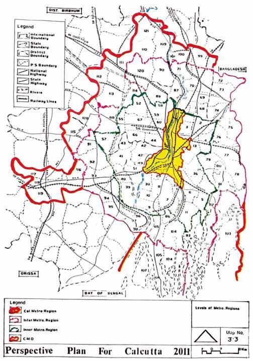
understand what is being supposedly communicated. For example, Figure 1.02 shows the distribution of towns by class (size of population) for the territorially extensive Calcutta Metropolitan Region. The less extensive core of the Calcutta Metropolitan District is barely visible, but is marked out with a thin, black, dashed line in the center of the map and is not specified at all in terms of class of settlement. If it were, it would presumably appear as a very big red dot in the middle of the map. In other words, on this map, metropolitan Kolkata is a “blank” space, and the map is drawing attention to the hierarchy of settlement size for everything other than the Calcutta Metropolitan District, which is shown on a completely separate map. With the Calcutta Metropolitan District missing, the map implies that the existence of an extremely polarized hierarchy of settlement distribution is two separate problems—that of the region as shown on one map, and that of the core as shown on another (see Figure 1.03).
Figure 1.01. Map showing the spatial ambition of A Perspective Plan for Calcutta: 2011. The 2011 plan aimed to discipline urban growth within a region defined by four nested zones. Beginning with the largest, the zones are entitled the Calcutta Metropolitan Region (thick red line), the Intermediate Metropolitan Region (pink dashed line), the Inner Metropolitan Region (green dashed line), and the Calcutta Metropolitan District (yellow area with red outline). Also shown, as an overlay, is the Ward 13 study area (yellow symbol).
(Source: Government of West Bengal, 1990. A Perspective Plan for Calcutta: 2011. Map 3.3. Kolkata, State Planning Board, Development & Planning Department, Government of West Bengal.)
45
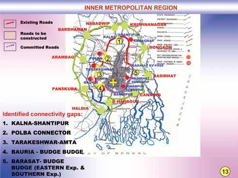
Figure 1.06.
zones. Note the shift from a visual language of dots and centering in the earlier plans toward an emphasis on lines and multidirectional flows. These two maps are from a set of 50 maps from a PowerPoint presentation and accordingly, are diagram-like to rapidly communicate the Plan to an audience. In the KMA map, pink lines show proposed arterial roads and green lines show existing arterial roads. The new arterial roads connect the inner core toward the north-east, where New Town and the airport are located, and the south-east, which is a growth area and a proposed, relocated district government center. The longest red line, which is
58 “Quieter” State Power
Map showing the distribution of proposed arterial roads within the Inner Metropolitan Area (left) and the Kolkata Metropolitan Area (KMA) (right)
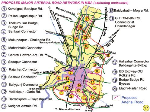
difficult to discern as is it looks like a pink line, is the proposed expressway (shown along the eastern edge of metropolitan Kolkata). The East Kolkata Wetlands area is not shown in this map and the proposed expressway is shown as going through them. This might be thought of as an example of “unmapping” (Roy, 2003) whereby the East Kolkata Wetlands are visioned as “undeveloped land”. Also shown, as an overlay, is the Ward 13 study area (yellow symbol).
(Source: Government of West Bengal, 2006. Comprehensive Mobility Plan 2001-2025 Map no. 13 and 17. Kolkata, Kolkata Metropolitan Development Authority through the Department of Urban Development and Municipal Affairs, Government of West Bengal.)
59
failed experiment for the “bi-nodal city” mentioned earlier in this chapter. While Madhyamgram, Kalyani and Gayeshpur were considered potentially suitable for this study, they were eliminated, as they are not proximate to the “city”—meaning the Kolkata Municipal Corporation area. Next, the new municipalities in the east of metropolitan Kolkata were studied. They were not considered suitable as they have exceptional development and ecological notoriety. In Rajarhat Gopalpur, urbanization is linked to the international airport at Dum Dum. Bidhan Nagar is anchored by spectacular, and contested, new towns and the East Kolkata Wetlands. They are the worlds largest wastewater fed aquaculture system (EKWMA, 2020) and are characterized by Ramsar-endorsed conservation, and the contestation of those measures.3
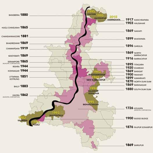
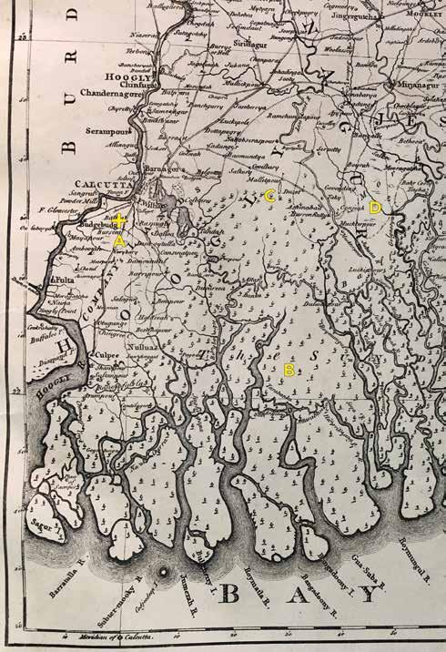
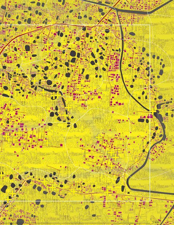
Figure 2.02. Map of the Kolkata Metropolitan Area. Municipal corporations and municipalities are shown in pink with the name and foundation date noted. Municipalities founded after independence and since the 1990s urban reforms are shown in brown with foundation dates noted in yellow. Panchayat (village council areas) are shown in light brown. The founding of a municipality is a politically motivated territorial decision - a “political technology” (Elden, 2010). For instance, on the northeast, the newest municipality of Haringhata is noted. In this case, a panchayat area with many education institutions became both metropolitan and municipal at the same time, while the many other panchayat areas already within the metropolitan area have been retained (or chosen to remain) at the panchayat level.
(Source: author, 2020; Census of India, 2011; Google Earth Pro, 2018; Kolkata Metropolitan Development Authority, 2020.)
72 Becoming Municipal
73
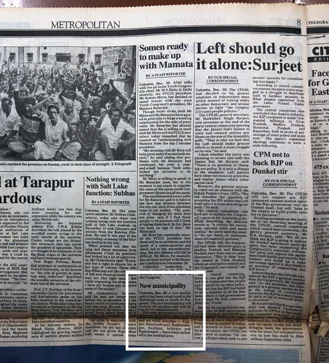
Figure 2.04. The public announcement for Maheshtala Municipality on December 21st, 1993. It reads, “Calcutta, Dec. 20: A new municipality has been constituted in the Maheshtala area in South 24 Parganas. The new municipality will include 40 moujhas and will be run by 12 commissioners. The state government has also declared the Pujali area of the same district as a ‘notified area’ and six other moujhas – Kalipur, Ramchadrapur, Raghunathpur, Raijbpur, Achhipur and Rajarampur – have been included in the notified area”. It is noteworthy that other “metropolitan” news of the day was the right-to-work activism among jute mill workers; the politics around the power bases of the All-India Youth Congress; and the land reforms of the ruling Communist Party India (Marxist)-led Left Front. The page encapsulates how Maheshtala Municipality was formed in a context of industrial decline and the rise of the so-called “Mamata phenomenon” in West Bengal (Ramaswamy, 2011), Mamata Banerjee being at that time a West Bengal Youth Congress member who later became the Chief Minister of West Bengal.
(Source: The Telegraph, 1993. New Municipality, p. 8. Kolkata.)
78 Becoming Municipal
79
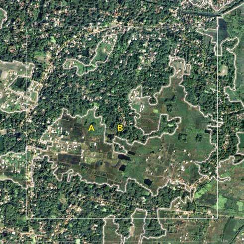
Figure 3.02. Enhanced, remote sensed image from 2004 of the Ward 13 study area (white square) showing “patches” of distinct, land cover mixes. “Patches” (bounded by white lines) are based on the mixture and relative abundance of five elementsbuildings, woody vegetation, herbaceous vegetation, paved surfaces, and bare soil - that can vary independently of one another in different situations.
A. Predominantly “jungly” paddy fields
B. Tree-lined ponds, plantations and gardens with scattered buildings
(Source: author and Google Earth Pro, 2020).
110 Visual Materials
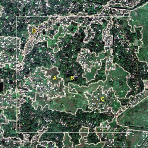
Figure 3.03. Enhanced, remote sensed image from 2018 of the Ward 13 study area (white square) showing “patches” of distinct, land cover mixes. “Patches” (bounded by white lines) are based on the mixture and relative abundance of five elementsbuildings, woody vegetation, herbaceous vegetation, paved surfaces, and bare soil - that can vary independently of one another in different situations.
A. Predominantly “jungly” paddy fields
B. Tree-lined ponds, plantations, and gardens with scattered buildings
C. Predominantly densely built-up buildings with some “jungly” paddy fields
D. Densely built-up buildings also with tree-lined ponds, plantations, and gardens
(Source: author and Google Earth Pro, 2020).
111
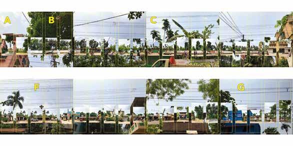
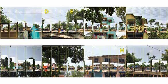
A. Multi-story apartment building
B. Walled bungalow also termed, bagan-bari (farmhouse)
C. Long, tall wall with locked gate
D. Tea shop
E. Plantation
F. Carpentry shop
G. Construction company
H. “Sweets” shop
(Source: author, 2020.)
132 Visual Materials
Figure 3.11. Visual documentation of the half kilometer transect walk encompassing the local, main road.
133
(Source: author, 2018.)
154 From the Household
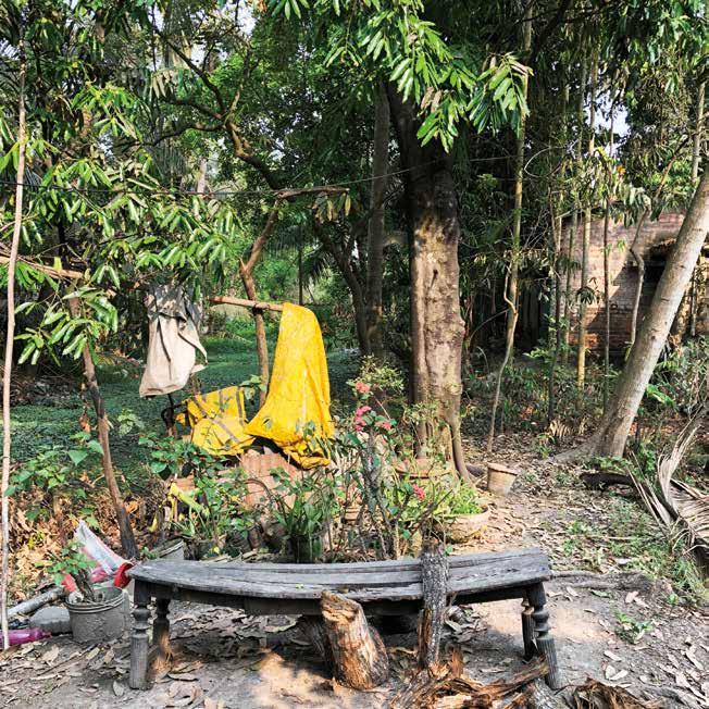
Figure 4.05. The “rivulet” or tidal creek covered in water plants on the left, as viewed through the tree-lined creek bank. The foreground space used for drying clothes and coconut, and for growing a small medicinal garden was created by filling in an edge of the tidal creek.
as now being in “bad shape,” further lamenting that the ponds created by residents from the creek are “not being tended” and “are getting encroached by shrubs and grass” (Resident, interview, L04, 2018). Before 1993, the panchayat (village council) was expected to “maintain” the waterways of the locality, including excavating clogged side channels and removing weeds. They would collect payments for this work, although residents recalled that funds often went directly to panchayat pradhans (village leaders) who, instead of fixing drainage problems went on to “enrich themselves” (Resident, interview L05, 2019). From the point of view of the participant residents, the tidal creek is now a poorly regulated, abandoned infrastructure. Such degradation of creeks and canals has been noted elsewhere in Kolkata (see Bose, 2008; Mukherjee, 2015).
In 1993, with the formation of the municipality, the water ecology again changed. Residents interviewed reported that by 1996, the parts of the Monikhali Canal System that cross the study area had become unreliable, resulting in excessive seasonal waterlogging of land adjacent to the canals and poor drainage of the land around the creek.3 Such seasonal waterlogging was not just an inconvenience. This made reliable, productive farming difficult. As I shall explore later, waterlogging was named by residents as a major contributing factor in farmers’ decisions to sell their paddy land, especially if it was in low-lying areas. Excessive seasonal waterlogging meant that “water would remain stagnant for three to four days at a stretch” and paddy plants would “start rotting” (Resident, interview, L04, 2018). The cultivation of paddy declined precipitously between 1996 and 2007. Although some residents persisted, a drainage renovation in 2007 which was undertaken for the Behala airfield made the problem worse. By 2015, cultivation, including subsistence vegetable farming, was discontinued among all but one household participating in this research.
The second phase in the recent history of water ecology in the study area relates to the renovation of the Begore Canal, starting in 2007. According to one resident, the Begore Canal “was not in existence” prior to 1993 (Resident, interview, L11, 2018). From the point of view of a resident this may well have felt true: the canal did exist, but was located far away, near the eastern boundary of a nearby airport.4 The 2007 work on the Begore Canal involved a range of engineering interventions: it was straightened, its depth and width were increased, and its banks stabilized. But most dramatically, it was realigned from running along the distant eastern edge of the airport to running through the study area (C in Figure 4.03). This renovation and realignment brought Begore to Ward 13, but not for the benefit of the residents. These works were intended to improve drainage of the adjacent Behala Airfield, which the central-level Airports Authority of India had
155
184 Cultivation Practices
of water. Of course, these maps, as colonial artefacts, erase the precolonial fluid ecologies and economies of the Ganga-Brahmaputra-Meghna Delta. But in fact, colonial-era use of the waterways for transport was continuous with precolonial uses. The historian Richard Eaton (1993) describes the early settlement of the delta as one of moving “frontiers.” The sacred geography of the Ganges River (today’s Bhagirathi-Hooghly River) was a powerful conduit that brought Brahaman settlers from the north from the sixth and fifth centuries B.C. (1993, p. 5). From the thirteenth century on, sporadic efforts were made to clear the mangrove and marshlands of the delta, initially by the Bengal Sultanate (1204-1575), then by the Mughal Empire (1575-1765) (1993, p. xxiv). Eaton (1993, p. 310) notes that the settlement of the delta was composed of several interwoven processes:
[T]he eastward movement and settlement of colonizers from points west [that is, from the long-settled Ganga/Bhagirathi-Hooghly River], the incorporation of frontier tribal peoples into the expanding agrarian civilization, and the natural population growth that accompanied the diffusion or the intensification of wet rice agriculture and the production of surplus food grains.
Geographer Kalyan Rudra’s (2018, p. 2) account of the dynamics of the Ganga in West Bengal verifies that the colonial Government of Bengal worked hard to understand the hydrology of the delta. From the late eighteenth century until the first half of the twentieth century, much
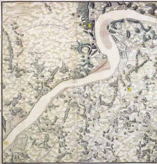
Figure 5.05. Part of a 1910 map of the “Delta of the Ganges,” with this fragment showing the western Ganga-Brahmaputra-Meghna Delta. The study area (yellow symbol) is marked on the western part of the map, southwest from Calcutta and of east of the Bhagirathi-Hooghly River.
A. “Morass” near the study area
B. Sunderbund (Sundarban) mangrove
C. Extent of tidal creeks
D. Another “morass”
(Source: Survey of India, 1910, The Delta of the Ganges; with the adjacent countries on the east: Comprehending the southern inland navigation. Inscribed to Francis Russel esq. by his affect. Friend J. Rennell. Published December 1, 1778. Rennell’s Bengal Atlas 1783, No. I. Calcutta, Survey of India. National Library of India, Kolkata.)
185
an
A. Patterning of paddy fields and tidal creeks
B. Swampy land or “morass”
C. Linear and clustered settlements with treed-lined ponds, home gardens, and plantations
D. Behala area mango plantation
E. Mangrove-lined creek
198 Cultivation Practices
Figure 5.10. A detailed 1785 colonial survey map of the southern periphery of Calcutta. Also shown, as
overlay, is the Ward 13 study area (white square).
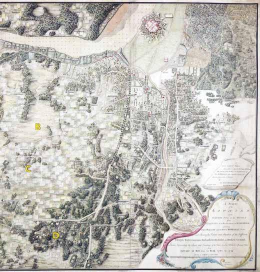
(Source: Mark Wood, 1785. A survey of the country on the eastern bank of the Hughly, from Calcutta to the Fortifications at Budgebudge, including Fort William and the Post at Manicolly Point, and shewing the extent and situation of the different courses, embankments, tanks, or broken ground, likewise representing the sands and soundings of the river at low water in spring tides, from January to May, from the year 1780 till 1784. 1 inch = 2 miles. Calcutta, Mark Wood, Capt. Of Engineers. The British Library, London.)
199
(Source: author, 2018.)

216 Lived Property
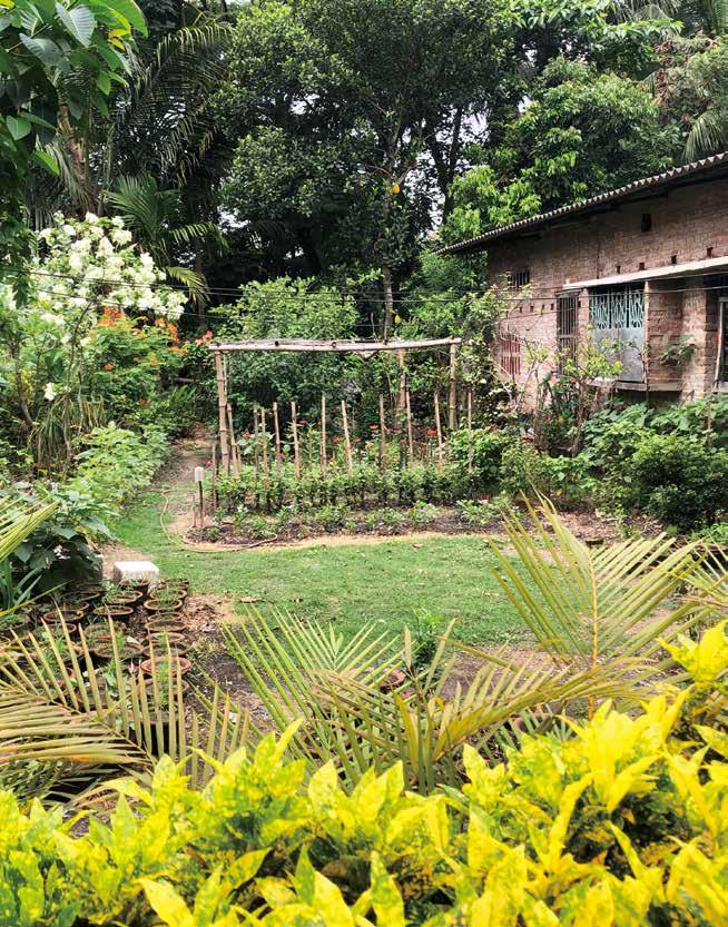
Figure 6.05. A long-term resident’s bagan described as a “hobby garden” with many flowering plants and a lawn in the foreground. Plantation trees can be seen in the near distance.
217
(Source: author, 2019.)
230 Lived Property
Figure 6.09. A long-term resident’s plantation on a tree-lined pond bund. The foreground tree and other wide-girth trees in the middle view are a mahogani (mahogany) plantation. Jungly former paddy fields and a colony can be seen in the far distance.
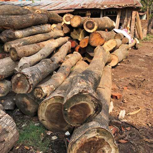
Figure 6.10. A Ward 13 sawmill yard with stored logs. Smaller logs are seen in the foreground and larger, more recently felled, local logs are seen stored behind. These logs are not considered valuable for re-sale and are stored until the owner pays for their milling. The mill—a shed where mostly imported logs are cut—is not visible.
(Source: author, 2018.)
231
264 “Basic” Infrastructure

(Source: author, 2019.)
265
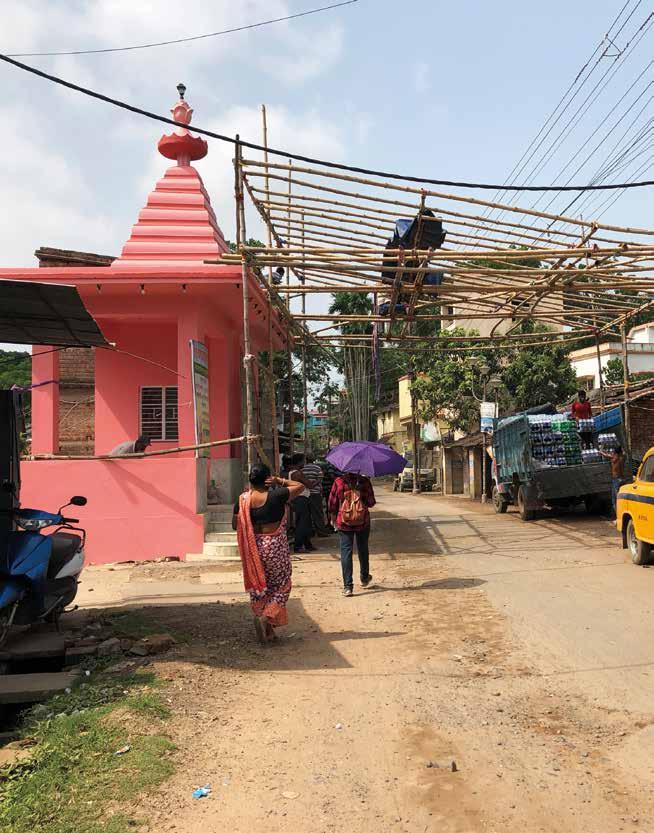
Figure 7.07. A local mandir (Hindu temple) located on the local main road. The mandir is the bright pink painted structure, seen on the left hand of the image. A partly installed bamboo canopy draped with a yet-to-be unfolded plastic shade cloth covers the road. This temporary infrastructure is one of many regular investments made in preparation for a community puja (act of worship).
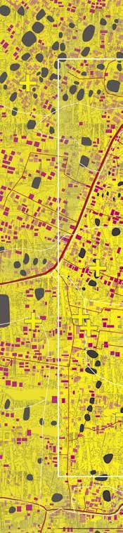
Figure 9.01. All study area data layers: Light pink rectangles: older buildings (2004 data). Dark pink rectangles: newer buildings (2018 data). Thick red lines: local, main roads (with cars and trucks). Thin red lines: pathway roads (with some or no cars). Yellow symbols: participant households (approximate location). White square: one kilometer-square study area. Yellow areas: Land cover patches with invented shading (local main road built up areas; wooded-settled areas; colonies; “jungly” former paddy land). White lines; para boundaries.
(Source: author, 2022; Google Earth Pro, 2018; and unassembled and unpublished GIS files provided by Maheshtala Municipality, 2019.)
294 Conclusion
295