EVERYDAY CYCLING IN SINGAPORE
PROTOTYPING A CYCLING NETWORK FOR ONE-NORTH DISTRICT
NUS School of Design and Environment | Department of Architecture
NUS MLA DESIGN STUDIO LA 4701 12 AUG - 22 NOV 2018
| Fan Lei Helen | Gao Chen Chen | Kong Lingchang | Kuan Wai Tuck Victor | Lam Si Yun Swan
Liu Xiaolei | Wang Hanfeng | Wang Zhe | Xu Linxin | Xu Yuexin
Yao Haomu | Yong Keng-Whye, Raymond
Tutor: Hwang Yun Hye
02
Fax: +65 67793078
Copyright @ 2019 Hwang Yun Hye (ed.)
ISBN: 978-981-14-0187-9
EVERYDAY CYCLING IN SINGAPORE 02
PROTOTYPING A CYCLING NETWORK FOR ONE-NORTH DISTRICT
Published by Department of Architecture School of Design and Environment National University of Singapore 4 Architecture Drive Singapore 117566 Tel: +65 65163452
FOREWORD
Dr Limin Hee Director, Centre for Liveable Cities (CLC)
There is an urgent need to reduce Singapore’s reliance on private cars by encouraging walking as well as cycling. In order to convince people of the mindset that cycling can also be an efficient mode of commuting, one of the key strategies would be to focus on creating better cycling infrastructure. The site of one-north was selected as an ideal site for the focus of the Masters students’ research and project ideas.
one-north is a 200-hectare development in the southwest of Singapore conceived to host a cluster of world-class research facilities and business-park space to support the growth of Biomedical Sciences, Infocomm Technology (ICT), Media, Physical Sciences and Engineering. The district is located in a strategic area, close to larger green networks like the Rail Corridor, the Round Island Route for cycling and the Southern Ridges that can be integrated with one-north’s green spine. However, being surrounded by a high density of uses does not guarantee an equally high frequency of usage. As an innovation hub immersed in greenery, one-north can make for an excellent cycling environment, but the challenge for cyclists in the area is to navigate the undulating terrain as well as the large roads surrounding the district.
The students of the everyday cycling 2 studio used both quantitative and qualitative methods to analyse one-north and its surroundings. Backed by scientific measurements as well as intuitive design methods, the students’ mandate was to deliver a comprehensive proposal at transforming one-north into a cyclable district. I am happy to have been able to contribute as a guest critic for the studio, and found this compendium a useful repository of insightful research findings, unrestrained and imaginative design solutions, which offer a glimpse of what everyday cycling can be re-imagined in one-north.
THE SECOND SERIES ON EVERYDAY CYCLING IN SINGAPORE
Hwang Yun Hye
Cycling as a form of urban transport is gaining attention in countries throughout the world. Singapore is no exception; it aims to become a cycling-friendly nation. As part of an active mobility initiative to meet that aim, 12 students in the Landscape Architecture (MLA) program, part of the Architecture Department in the National University of Singapore, participated in a studio to develop a cycling landscape infrastructure for a site in the One-North District over a 14-week period (August – November 2016). Work included preliminary research to understand the site context, in-depth field trips to identify problems and challenges within the assigned community, and design activities producing relevant solutions and techniques. Many local collaborators, notably Limin Hee and Luther Seet (CLC), Zhang Qian and Jin Hao (JTC), Cheah Kok Ming and Terrence Tan (NUS), Michael van Eggermond (FCL), and Chen Munn Tham (PTV Asia), provided practical perspectives that raised students’ awareness of the architectural, political, and technical aspects of cyclability and walkability. Their efforts contributed to the diversification of perceptions, the raising/ highlighting of problems, the development of practical designs, and the creation of a vision for a prototype cycling network in One-North District.
This book is a compilation of work from the studio. The first half of the book documents the sequential studio process. The studio began with site analysis as group work to explain the context and motivate subsequent design topics; it went on to include field trips and ended with design suggestions. Three distinct design outcomes appear in the second half of the book:
2) Everyday Cycling: Short-distance commuters cycling everywhere;
1) Mobility Hub: Reshaping major destinations to promote everyday cycling;
3) New Urban Vision: Cycling networks as integral transportation systems and part of city revival. The book concludes with a studio chronology and reflections on what we came away with.
We hope the book will launch new discussions of an alternative mobility network that planners and designers can use to create a healthier compact city.


10 11 STUDIO INTRODUCTION P12 - P15 CHRONOLOGY PRELIMINARY RESEARCH P16 - P29 PROPOSALS REFLECTIONS Group 1: Commuters to major destinations Group 2: Commuters within the district Group 3: Long-distance commuters P30 - P93 P276 - P281 P94 - P157 P158 - P219 P220 - P275
EVERYDAY CYCLING IN SINGAPORE 2
Hwang Yun Hye, Assistant Professor, Department of Architecture, School of Design and Environment, National University of Singapore
PREAMBLE/ ISSUE
Beyond the notion of a city in a garden, the nation’s green policy focuses on liveability, sustainability and resilience, achieved, for example, by strengthening the green infrastructure, increasing ecological and green regimes, and creating more pedestrianized streets. A green transport policy might serve as a framework for sustainable land use and transportation plans over the next 30 years. Many alternatives, including walking, cycling, transit-oriented development, stop-lights etc., could be considered as part of such a policy. Among these alternatives, the creation of a cycling friendly landscape infrastructure is a good starting point. Despite Singapore’s attempts to create bicycle routes and infrastructures, there are still many challenges for ordinary, everyday cyclists. The majority of the extensive cycling routes cater to leisure and recreation cycling; major shopping districts prohibit cycling; the PCN does not function as an optimal cycling route, as it is often bisected by physical barriers, such as highways, canals, bridges, and steps; obstacles to cycling include unlinked roadways, high speed vehicles, heavy traffic, uneven surface, a lack of safe intersection crossings, narrow passages, conflicts with pedestrians, and unshaded paths. Only 0.9% of the resident working population over the age of 15 uses bicycles to commute. This figure illustrates how undesirable everyday cycling is in Singapore.
SITE
Located in the southwester part of Singapore, One-North district is designed as a technological and innovation hub hosting a cluster of research facilities and a business park space with over 400 companies and about 46,000 workers. Around 1.7milion square metres of office space are devoted to biomedical sciences, information and communications technology (ICT), media, physical sciences, and engineering. The park spans Biopolis and Fusionopolis, and connects Ayer Rajah Crescent and Rochester Park with Holland Village and Queens Town. Its combination of educational institutions, residences and communal amenities creates a work-live-play-learn environment. Efforts have been made to improve connectivity by providing shuttle buses, flyovers connecting some destinations, the test-bedding of autonomous vehicles, and a long-term master plan for the next 40 years. However, traffic woes persist - traffic congestion is an issue for the business park as is the continuing development and construction. The improvement of mobility is a priority. One-North district is selected as the ‘landing’ site of this module and serves as a point of reference for all design activities. Sites selected by students should be based on users’ demands in the district and its surrounding context. Students should work as a group based on problem statements and topics arising during the research period, aided by the various design exercises and input sessions.
PROJECT
How do we undertake these types of challenges in the field of landscape architecture? How do we mediate between car-oriented traffic policies and an ecological vision of genuine sustainability? How do we curate the cycling routes at different scales? Ultimately, how do we enable more people get on their bicycles every day? This studio aims to address design and planning practices of cycling routes towards the establishment of a liveable city and propose ways to integrate them into our urban environments. We will capitalize on the academic nature of the studio to develop ideas and schemes free of restrictions commonly faced in practice, and beyond any constraints of political correctness. Multiple issues, such as environmental sustainability, walkability, human health, identity, multi functionality, and liveability, will be examined.
Students are expected to develop their ability to read existing landscapes, to assess the environmental impact of design and planning decisions, and to convert their vision into a feasible landscape architectural form.
LEARNING OBJECTIVES AND APPROACHES
The studio has three objectives:
(1) To understand how landscape architecture drives mobility issues in a high-dense tropical context.
(2) To acquire basic knowledge related to the studio topic, for example, heat mitigation and stormwater management strategies, landscape as infrastructure, and promoting health through design.
(3) To synthesize research outcomes and site analysis into consolidated design forms through logical thinking processes.
To facilitate the studio objectives, five basic studio approaches will be emphasized throughout the semester. A high degree of invention, pragmatism, and practicality is expected in the planning and design proposals.
(1) Research centred design: there will be an emphasis on exploring the relationship between documentation and analytical research using diverse conceptual frameworks.
(2) Site specificity: designs will be based on a strong awareness of the geographical characteristics of the surveyed sites, locality, and reality.
(3)Wide ranging spectrum: the spectrum of research will range from a district-scale plan to a landscape detail profile, including a tree along a street.
(4) Mobility: mapping exercises will provide an understanding of the traffic systems and human flows; a review of design guidelines will inform design decisions.
(5) Multi-functionality: as cyclable landscapes can potentially encompass various functional layers, students will be encouraged to produce solutions that address multiple concerns simultaneously.
ACTIVITIES OVERVIEW
This is the third studio in Master Programme of Landscape Architecture, with participants from NUS architecture and graduates from other universities with a Bachelor of Landscape Architecture or a degree in an associated field. The 14-week period includes three weeks of preliminary research to understand site context, with in-depth input sessions from professionals and field trips to identify problems and challenges. The next three weeks will be devoted to applied research activities (including site observation & measurements, surveys and detailed mappings) to acquire knowledge relevant to creating design strategies. The last eight weeks will focus on design application, culminating in a convincing design solution for the issues identified as a team member on each of the three subgroups. A group of experts, including transportation consultants, urban planners from CLC, and researchers in thermal comfort and walkability measurement will help students avoid the pitfalls of shallow and superficial interventions in this academic exercise. They will offer immediate and accurate perspectives on the challenges of and the opportunities inherent in increasing mobility in high dense cities, propose scientific methods to measure cyclablity, and explain how collected data can be applied to address these issues. Students will be tasked to work in subgroups according to the requirements of each stage of the studio. They may end up with one group project after discussing it with tutors.
12 13
REFERENCES
1. Policies and plans
- URA master plan 2014 https://www.ura.gov.sg/uol/master-plan.aspx
- Ministry of Transport Singapore https://www.mot.gov.sg/about-mot/land-transport/cycling
- Walk Cycle Ride SG by LTA https://www.lta.gov.sg/content/ltaweb/en/walk-cycle-ride.html
- Creating Healthy Places through Active Mobility (CLC) https://www.clc.gov.sg/researchpublications/publications/urban-systemsstudies/view/creating-healthy-places-through-activemobility Creating Liveable Cities Through Car-Lite Urban Mobility (CLC) https:// www.clc.gov.sg/research-publications/publications/urban-systemsstudies/view/creating-liveable-cities-through-car-lite-urbanmobility
- One north development by JTC https://www.jtc.gov.sg/industrial-land-and-space/Pages/onenorth.aspx
- Pulse @ one-north Newsletter https://www.jtc.gov.sg/news-andpublications/publications/Pulse/2018_06/files/assets/common/ downloads/publication.pdf
- Maps - Shuttle Bus Service, - one-north Estate Map
- One North Masterplan - Masterplans - Zaha Hadid Architects www.zahahadid.com/masterplans/one-north-masterplan/
- One-north district sees healthy growth but traffic woes persist, Channel news Asia, 28 Dec 2016, Patrick John Lim https://www. channelnewsasia.com/news/singapore/one-north-districtsees-healthy-growth-but-traffic-woes-persist-7657396
2. Case studies and guidelines
- Best cycling cities https://www.wired.com/story/world-best-cycling-cities-copenhagenize/

- Copenhagen cycling design strategies http://www.eltis.org/sites/default/files/casestudies/documents/copenhagens_cycling_ strategy.pdf
- Active Design Guidelines - Center for Active Design _ promoting health through design https://centerforactivedesign.org/dl/ guidelines.pdf https://centerforactivedesign.org/
- Tan, P. Y., Liao K. H, Hwang, Y. H., & Vincent Chua, 2018, Nature, place, and people: forging connections through neighbourhood landscape design, World Scientific, Singapore, Chapter 5: Designing Neighbourhood Landscapes with Landscape Services https:// www.worldscientific.com/doi/pdf/10.1142/9789813236035_0005
- Hwang, Yun Hye, Qin Jie Geraldine Lum, and Yeow Kwang Derek Chan. "Micro-scale thermal performance of tropical urban parks in Singapore." Building and Environment 94 (2015): 467-476. - Cooler Calmer Singapore http://www.fcl.ethz.ch/research/ responsive-cities/cooler-calmersingapore.html
3. Measurement methods and tools
- Urban Network Analysis Toolbox for ArcGIS - http://cityform.mit.edu/projects/urban-networkanalysis.html
- PTV Vissim - Multimodal capacity study Heidelberg https://www.youtube.com/watch?v=18q4is-xyI8
- Mobile MULTI – survey sensor https://www.eco-compteur.com/en/products/multirange/mobile-multi
- Kallus, Rachel. "From abstract to concrete: Subjective reading of urban space." Journal of Urban Design 6.2 (2001): 129-150. https://www-tandfonlinecom.libproxy1.nus.edu.sg/doi/pdf/10.1080/13574800120057818?needAccess=true - Honjo, Tsuyoshi, et al. "Thermal comfort along the marathon course of the 2020 Tokyo Olympics." International journal of biometeorology (2018): 1-13 https://link-springercom.libproxy1.nus.edu.sg/article/10.1007%2Fs00484-018-1539-x
- Forsyth, Ann. "What is a walkable place? The walkability debate in urban design." Urban design international 20.4 (2015): 274-292. 13.http://bb2sz3ek3z.search.serialssolutions.com/?sid=google&auinit=A&aulast=Forsyth&atitl e=What+is+a+walkable+place%3F+The+walkability+debate+in+urban+design&id=doi:10.105 7/ udi.2015.22&title=Urban+design+international+(London,+England)&volume=20&issue=4&d ate=2015&spage=274&issn=1357-5317
- Ewing, Reid, and Susan Handy. "Measuring the unmeasurable: Urban design qualities related to walkability." Journal of Urban design 14.1 (2009): 65-84. https://www-tandfonlinecom.libproxy1.nus.edu.sg/doi/ pdf/10.1080/13574800802451155?needAccess=true
4. Ect. - Engaging Mobility (publications, big data, bike to the future, past projects) http://www.fcl.ethz.ch/research/ responsive-cities/engaging-mobility.html - More materials on IVLE > Source https://ivle.nus.edu.sg/v1/File/Student/Default. aspx?CourseID=3ad521de-7b7a-4831-9ba080bcbd1c819e
14
16 17 CHRONOLOGY 13 August - 22 November 2018
The studio started off with an introduction to the project given by the studio tutor, Hwang Yun Hye The students split themselves into 3 teams to collect related reading materials and resources including policies & plans, case studies & guidelines, and measurement methods & tools.


13 Aug | Studio Orientation

13 Aug |
Three Seminars about Cycling in Singapore
After the project introduction, the studio attended 3 seminars on topics related to the project. The first seminar that the studio has taken is transport history of Singapore given by Chen Munn THAM, Director, PTV Asia, followed by the second seminar presented by Luther Seet, Senior Assistant Director, Centre for Liveable Cities (CLC) regarding the research on walkability and cyclability of Singapore and One-North district. The day was concluded with the last seminars on thermal comfort and landscape design optimisation guided by Dr. Terrence Chun Liang TAN, Research fellow, NUS Building Science.
To prepare for the first group field trip, the students planned a cycling route that explores different segments of One-North from the old residential Ghim Moh district to the newly developed business area around Buona Vista using the existing cycling route.
17 Aug | Field Trip Management and Cycling Route Selection
17 Aug | Group Discussion and Tool Management
According to individual initial knowledge and interest of the site, 12 students were divided into three groups to do site investigation and with three different design approaches. The groups are: commuters within the district; long-distance commuters; and commuters to major destinations. Meanwhile, everyone is actively preparing for the thermal comfort tool installation for fied trip.


18 19
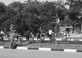
Prof Hwang Yun Hye and 12 students gathered for the first site visit at Holland Drove starting from 8am and cycled for more than 10km till noon to witness different types of commuters and their experiences in and around One-North region. Cycling routes includes Ulu pandan Park Connector, Commonwealth Ave, Queensway, One-North Ave, Dover Rd, Clementi Rd and AYE.
20 Aug | Group Site Visit

20
Aug |
Walkability Measurement through GIS Analysis

After the site visit, Michael van Eggermond, Senior Researcher from ETH Centre gave us an eye-opening lecture about walkability measurement with the use of GIS programming. This lecture also prepared us to anticipate what are the different approaches each team can make to analyse mobility issues.
Tutors from PTV Asia gave us a traffic simulation workshop using Vissim/Viswalk software that allow us to simulate existing and proposed traffic condition. The students have a more indepth of the traffic simulation technology through the tutors’ detailed explanation and demonstration.


23 Aug | Traffic Simulation Workshop
25-27 Aug | Site Survey
During 25th-27th August, three groups of four sudents survyed two targeted groups - cyclists and non-cyclists- about their opinions on cycling in Singapore and particularly in their neighbourhood. We got 283 valid questionnaires and recorded the travel routes of every commuters and their evaluation on connectivity, comfortability and safety of their commuting routes.

20 21
This is the first time for us analyse the collected survey data and site measurements. Analysis includes classification of roads, land use, land ownerships, public open spaces, terrain, thermal comfort, health, walkability and cycablity, etc. Accoding to this discussion, the three desginated groups clarify the data needed in the next step according to their design approaches.
30 Aug | Subgroup Pin-ups & Discussion

6 Sep Site Analysis &
Subgroup Presentation
A group studio preliminary analysis review was held so that each group could conduct sharing of gathered data while checking on individuals’ progression to learn from each other. Everyone had the opportunity to comment and give suggestions on others’ analysis, helping each teams’ work to improve and move ahead.


Every group went through and discussed the site issues with Prof Hwang and determined the group’s target site. Each group marked their target site on the map and discussed their design concept with other groups.
17 Sep | Synthesis &
Site Selection
8 Oct | Mid Review
We are very honored to have invited 8 tutors from CLC, PTV Asia and other professors who listened critically to our mid-review presentation and suggested an array of useful methods and strategies to counter our respective site issues. After the review, the tutors were very satisfied with our mid-term results and made some general advice for the next step development.

Reviewers:
Limin Hee, Director, Centre for Liveable Cities (CLC)
Luther Seet, Senior Assistant Director, Centre for Liveable Cities (CLC)
Jin Hao, Assistant Manager, New Estates Division 2, JTC
Terrence Chun Liang TAN, Research fellow, NUS Building Science
Cheah Kok Ming, Associate Professor, National University of Singapore
Yumi Lee, Visiting Professor, Seoul National University
Chen Munn THAM, Director, PTV Asia
22 23
Prof Hwang and three subgroups met at site. For the major destination group, Prof Hwang emphasized the importance of human flow in MRT junction area, Timber+ commercial area and factory area. For the long distance group, Prof Hwang suggest to pay more attention on neighbourhood community.
22 Oct | Subgroup site visit with the tutor


1
Nov
Design Development Presentation
Each student has generated detailed design on their target area according to their respective own design strategy. Some students have done physical models to better illustrate their own designs. Prof Hwang patiently answered all kinds of design questions for us and proposed some alternative suggestions.
After more than three months of hard work, we finally reached to our final review. We invited mostly tutors and professionals who attended in our mid-term review to follow up on our completed projects. The students reported their research results and designs in a professional manner
22 Nov | Final Review
22 Nov | Final Review
After finishing each group presentation, the critics comment on the group work and each student's work. All the tutors affirmed our design achievements and expressed their own vision of cycling in Singapore. We concluded with a light discussion on the possible future cycling planning in one north region and the rest of singapore.


Reviewers:
Limin Hee, Director, Centre for Liveable Cities (CLC)
Luther Seet, Senior Assistant Director, Centre for Liveable Cities (CLC)
Zhang Qian, Manager, JTC
Jin Hao, Assistant Manager, New Estates Division 2, JTC
Terrence Chun Liang TAN, Research fellow, NUS Building Science
Michael van Eggermond, Senior Researcher, FCL, ETH Centre
Cheah Kok Ming, Associate Professor, National University of Singapore
Yumi Lee, Visiting Professor, Seoul National University
Rudi Maria Frans Anne Stouffs Associate Professor, National University of Singapore

24 25


PRELIMINARY RESEARCH
SINGAPORE REGION
European Cycling cities Asian Cycling Cities Cycling Policies Walkability & Cyclability Consideration Design Guidelines for Cycling in Relation to Health Thermal Comfort Measurement History of the Site Physical Condition & Site Analysis Survey Method & Survey Result
30 31
EUROPEAN CYCLING CITIES
Practicality
COPENHAGEN INDEX

International Cycling-Friendly Standards
THE 14 PARAMETERS
Source : Public Transport Council. Comparison of Rail Fares Between Singapore and 35 Major Cities Around The World. https://www.ptc.gov.sg/docs/defaultsource/publications-and-papers/180305-2-ptc-cities-comparison-report-2016.pdf
Cost of Living Comparison Between Netherlands and Singapore. https://www.numbeo.com/cost-of-living/compare_countries_result. jsp?country1=Netherlands&country2=Singapore
Public Transport Utilisation - Average Daily Public Transport Ridership. Data.gov.sg. https://data.gov.sg/dataset/public-transport-utilisation-averagepublic-transport-ridership
1. Advocacy
How is the city’s advocacy NGOs regarded and what level of influence does it have?

2. Bicycle Culture
Has the bicycle re-established itself as transport among regular citizens or only sub-cultures?
3. Bicycle Facilities
Are there readily accessible bike racks, ramps on stairs, space allocated on trains and buses and well-designed way finding, etc?
4. Bicycle Infrastructure
How does the city’s bicycle infrastructure rate? R


5. Bike Share Programme
Does the city have a comprehensive and well-used bike-sharing programme?
6. Gender Split
What percentage of the city’s cyclists are male and female?
7. Modal Share For Bicycles:
What percentage of modal share is made up by cyclists?
8. Model Share Increase Since 2006
What has the increase in modal share been since 2006 - the year that urban cycling started to kick off?
9. Perception of Safety
Is the perception of safety of the cyclists in the city, reflected in helmet-wearing rates, positive or are cyclists riding scared due to helmet promotion and scare campaigns?
10. Politics
What is the political climate regarding urban cycling?
11. Social Acceptance
How do drivers and the community at large regard urban cyclists?
12. Urban Planning

How much emphasis do the city’s planners place on bicycle infrastructure - and are they well-informed about international best practice?
13. Traffic Calming
What efforts have been made to lower speed limits - for example 30 km/h zones - and generally calm traffic in order to provide greater safety to pedestrians and cyclists?
14. Cargo Bikes and Logistics
Is the city embracing the potential of cargo bikes - both for private citizens and businesses?
32 33
MODE OF TRANSPORT Statistics and Trends SINGAPORE GRONINGEN COPENHAGEN DENSITY PROJECTED CYCLING PERCENTAGE Mode of Commuting Bicycle Walk Public Transport Car 36 % 29 % 28 % 7 % Mode of Commuting Bicycle Walk Public Transport Car 61 % 35 % 3 % 1 % Mode of Commuting Bicycle Walk Public Transport Car 66 % 31 % <2 % <1 % Mode of Commuting Bicycle Walk Public Transport Car Population: 583,525 Area: 88.25 km² Density: 6612 ppl/ km² Population: 200.336 Area: 83.75 km² Density: 2392 ppl/ km² Population: 5,607,000 Area: 719 km² Density: 7796 ppl/ km² Commute with Bicycle Population Growth Total Bicycle Path/Lane Length 1.5% 230km ? km Cyclist are able to access to public roads 416km Mixture of Bicycle Lane, Path and Green Network 700km 61% ?% 36% 583,525 200,336 5,607,000 6,231,082 x 0.3 x 2.84 x 12.3 x 0.11 x 2.04 x ? x 3 50% 600,100 225,000 4.5% Commute with Bicycle Population Growth Total Bicycle Path/Lane Length Commute with Bicycle Population Growth Total Bicycle Path/Lane Length COPENHAGEN VS SINGAPORE Transportation Fee During Peak Hours Transportation Fee During Off Peak Hours
of Public Transport GRONINGEN VS SINGAPORE Transportation Fee During Peak Hours One-way Ticket (Local Transport) Monthly Pass (Regular Price) Taxi Start (Normal Tariff) Taxi 1km (Normal Tariff) Taxi 1hr Waiting (Normal Tariff) Gasoline (1 Liter) SGD 4.62 127.37 6.37 3.45 49.75 2.50 SGD 1.70 100 3.50 0.55 17.50 2.26 % Diff - 63.18% - 21.49% - 45.04% - 84.08% - 64.83% -9.53% SINGAPORE Public Transport Satisfactory Level, 2017 Bus 96.7% MRT 91.8% In GRQ In SG
Short Distance Commuting Within Neighborhood Short Distance Commuting Towards Final Destination Transitional Commuting Between Major Transport Destinations Short Distance Commuting Towards Major Transport Destination 5 - 15mins 5 - 15mins Within 15mins Within 15 - 30mins Within 15 - 30mins Short Distance Commuting Towards Final Destination Public Transport Possible Cycling Route 4 CYCLING SCENARIO WITHIN 30 MINS
Source Copenhagen Index, Copenhagenize Design Company, 2017. http://copenhagenizeindex.eu/criteria.html
EUROPEAN CYCLING CITIES
Critical Understanding of Cycling Strategies
SINGAPORE GRONINGEN COPENHAGEN
Cargo Bike
Additional Carriage and Parking
Does current parking areas enough for cargo bike parking?
Is cargo bike available for sale?

PLUSnet
Communication while Cycling
Does Singapore pedestrian path and vehicular lane has enough space for more than 1 bike lane/path per direction?


1 Good Cycling Tracks All Year Round
Law Protection
Against liability in traffic accidents

How much rights can we give to cyclist without disrupting current road condition?
Viable
Transport Option
For a knowledge-intensive economy
Can our CBD integrate cycling possibility? How can we integrate optimal pedestrian and public transport facilities with cycling? How to balance the ratio of ridership of different transport nodes?

3 Constant Momentum Building of Bike Underpass to Overcome Obstacles


Greater Accessibility

Barrier Free MRT, Pedestrian Overhead Bridges with Ramp
CYCLING INFRASTRUCTURE COMPARISON

Critical Understanding of Cycling Infrastructure Case Studies SINGAPORE GRONINGEN COPENHAGEN BARCELONA

Will these facilities and infrastructure serve as assests or liabilities for cyclist?

Facilitating Cycling

Additional Bicycle Facilities and Infastructure
CYCLING LANES

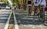
Designated cycling lane highlighted in blue to alert drivers and pedestrian, maintain cyclists’ connectivity for cyclist and upkeeping their momentum
Designated cycling lane highlighted in red to alert drivers and pedestrian, maintain cyclists’ connectivity for cyclist and upkeeping their momentum
Designated cycling lane with bicycle icon or highlighted in red to alert drivers and pedestrian. Furthermore, street elements such as curbs and bollards are placed to serve as physical barrier, increasing cyclist safety
No proper cycling lane, however, there’s a system where cyclist share lane with public buses, this highlights the multifunctional and adaptability of roads during different situations

Will cycling be an important transport node to be used in unfavorable condition?
Are our pedestrian accessibility aiding infrastructure a hindrance for cyclist/neglecting cycling uses?
Are our focus concentrating too much on intra-town development and neglecting generic enforcement of inter-residential town? Retrofitting old residential towns?
5 Cyclist Adaptability of Using Bike Lane or Path


Designated cycling paths clearly separates pedestrians from cyclist, however street layout has been may isolate interaction between cyclist and pedestrian
Designated cycling paths is not as bluntly in separating pedestrians from cyclist, this allow a more harmonious street dynamic
Similar to Groningen, Copenhagen designated cycling paths allow a more interaction between pedestrian and cyclist, giving a more recreational approach towards commuting

Very distinct and clear separation of cycling paths demarcated with vibrant red paving material. Speed regulating strips help to reduce the cyclist’s speed This also gives opportunity for cyclist to interact with pedestrian
Is the transition of Cycling town to typical town smooth?

2 4 6 Smooth Bike Path / Lane High Maintenance Sustainable Strategies Smart technology, Low cost Willingness to Share Openness to share footpath
Cyclist and Vehicles generally head towards the same direction, a systematic approach which enhance one directional momentum however, it also restricts cross directional movement.
Cyclist are given the advantage to do cross directional crossing which boost their convenience and accessibility to designated areas which are adjacent from their initial location, however this system creates conflicts amongst drivers, increasing risk of road accident and lowers driving experience
Junction Crossing for cyclist is isolated from pedestrian designated path to minimise cogging of traffic islands or waiting points.
Small junctions, easier to manage & control flow of pedestrians / cyclist with effective traffic control elements (additional traffic crossing timing can be given to senior citizens, sensory path to allow more access time and frequency to cross)
Is our current vehicular pedestrian infrastructure feasible for riding?

Is there smart tech but low cost innovations to mitigate climatic conditions in Singapore?

With the increase of cyclist on road, will the willingness of sharing be affected thus affecting current riders-pedestrian relationship?


Source : The City of Copenhagen’s Bicycle Strategy, 2011-2015. http://www.eltis.org/sites/default/files/case-studies/documents/copenhagens_ cycling_strategy.pdf Groningen, Cycling City, Cycling Strategy, 2015 - 2025. https://groningenfietsstad.nl/friksbeheer/wp-content/uploads/2016/05/ Groningen_CycleCity_Strategy_2015-2025.pdf Land Transport Master Plan, 2013, Singapore. https://www.lta.gov.sg/content/dam/ltaweb/corp/PublicationsResearch/files/ReportNewsletter/ LTMP2013Report.pdf
Pedestrian crossing is not as clearly demarcated as compared to Copenhagen and road infrastructure contributes for better cycling experience has affected pedestrian flow
Though pedestrian crossing does not have bold demarcation with only dotted white lines, due to the ratio of pedestrians compared to cyclist on the street, crossing has stayed to be pedestrian centric

Dotted white lines at the border to indicated shared pedestrian & cyclist crossing. Weak control of flow

34 35
Clear demarcation of pedestrian crossing with cyclist crossing at the sides to facilitate better perpendicular movement
PEDESTRIANS
CYCLING PATHS JUNCTIONS
CROSSING
1
4 6
2
5 7
CYCLING INFRASTRUCTURE COMPARISON
Critical Understanding of Cycling Infrastructure Case Studies

SINGAPORE GRONINGEN COPENHAGEN BARCELONA
BICYCLE PARKING
Indoor bicycle park areas on top of outdoor parking are often available to meet the demands for the huge pool of cyclist in Copenhagen. However, unlike Groningen, the amount of bicycle is lesser which result to better looking parking condition
Indoor bicycle park areas on top of outdoor parking are often available to meet the demands for the huge pool of cyclist in Groningen. However, there are too many bicycles which results parking area to be overly packed
Bicycle parking are mainly in outdoors and not always in good condition


Bicycle parking can be found both in sheltered and open-air outdoors and can be parked both personal and shared bike
GRONINGEN
SINGAPORE
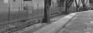
A) Absence of Kerb Physical barriers such as curb that also served as disturbance to cyclist and pedestrian is hardly present on street that drastically improve walking and cycling flow.
A) Adequate amount of road lamps that retain safety for bike riding at night
COPENHAGEN BARCELONA STREET ELEMENTS
A) Utilising street trees to caste shading on street increasing riding and walking comfort while increase street attractiveness

A) On-road markings “LOOK” alerting pedestrians & cyclist when crossing


B)
On top of bike lanes being generally gentle, some bike lanes installed rubber poles with reflective surface are beside vehicular road to provide better demarcation and road awareness both day and night
Bike lanes are generally gentle which makes it easily for cyclist of all age and


condition to ride
Bike lanes with the opposite direction are placed together to allow adaption of lanes during different periods in the day
Bike lanes are mostly unavailable which makes it difficult for cyclist to cycle on road as safely as other countries. However, this also reduce the need of designated space for a new lane in the already confined road space in Singapore TYPES

B) Lack of elevation difference on streets may result to flooding prone scenarios that eliminates cycling or walking as a choice to commute
B) Insufficient road signage to address informal crossing of cyclist that possibly affect traffic condition. Cyclist law enforcement may be overly protective towards cyclist
B) Road buffer is well integrated with landscape elements to soften streetscape


B) Road marking at informal crossings, to alert drivers / cyclist / pedestrians
blue demarcation
B) Cyling lane with only red demarcation and duel directional Cycling path by Street Barrier Elements with clear demarcation of the direction of flow. Street Barrier Elements are also coated with white strips to create more awareness especially amongst drivers
C) Streets do not have car parking on mid-big roads that allows room for cycling lane,small streets do not have cycling demarcation thus allowing street parking which ease congestion around the major roads while utilising the mobility of cycling which can easily manoeuvre in small streets.

Shared bike cycling areas is demarcated by white stripes, this method is easily applicable and adjustable on roads dependent on the changing frequency of parking
Shared bike cycling areas is demarcated by white stripes, this method is easily applicable and adjustable on roads dependent on the changing frequency of parking
Shared bike cycling areas is designated according to the specific bike brands to allow better way finding, maintenance and outlook. However, this also restricts door to door transportation and parking may be inaccessible to certain users
Shared bike cycling areas is demarcated by yellow stripes, this method is easily applicable and adjustable on roads dependent on the changing frequency of parking
36 37
A) Path designated for only cycling with integration with pedestrian pat
A) Wide shared pathway segregated with Green Buffer (strip) of separation and Cycling path with speed regulating strips a simple white strip
Segregated Vehicles and duel directional Cycling path by Concrete Buffer (strip)
B) Segregated Pedestrian and Cycling path by Green Buffer (strip)
BICYCLE FACILITIES AND INFRASTRUCTURE
C) Shared pathway with distinctive red paving for demarcate
A) Segregated Pedestrian and Cycling path by overhead Signages & different use of material
health
OF PATH
BICYCLE PARKING
ASIAN CYCLING CITIES

Critical Understanding of Cycling Strategies
CYCLING LOOP SYSTEM


Critical Understanding of Cycling Strategies
Singapore
Longer Journeys
Heading into the city for shopping, commuting to work, are almost exclusively taken by train
Road Conditions
Hostile / narrow crowded sidewalk shared with pedestrians, a stressful experience
Minor Destinations
Residents have to cycle no more than 5 to 10 mins to reach supermarkets, kindergartens, schools, doctors, dentists, in fact most necessities for everyday living are just a short ride away
38 39
Inconvenient & Expensive
Parking spaces can cost more per month than a small apartment in the suburbs
Short Trips around Neighbourhood Cycle to the station where they park & take a train to their final destination
JAPAN
JAPAN
ASIAN CYCLING CITIES
Critical Understanding of Cycling Strategies
JAPAN
Streets | Weak & No Distinctive Cycling Path
Junctions | Bold & Distinctive Cycling Lanes


Streets | Bold & Distinctive Cycling Path
Junctions | Weak & No Distinct Cycling Lanes / Markings / Logos / Strips
Cycling Lanes in Japan & Singapore
Japan Japan Japan & Singapore Japan & Singapore
Bicycle tack within sidewalk visually segrated from pedestrians by road marking
Cross - Reference

40 41
FIGURE 5. Two types of intersecctions: left, pedestrian crossing only; right, with bicycle crossing strip.
Bicycle road
Tokyo Singapore 5.6 million Population Bicycle Private (Cars & Motorbikes) Public Transport Cycling paths Vision 32% 66% 2030 - 700km 9.24 million 12% 51% 2020 -120km 14%: 1.3million 2%: 112,000 126 km 1km = 10.2600 cyclist 1m = 10.26 cyclist 230 km 1km = 487 cyclist 1m = 0.5 cyclist
Bicycle lane
Sidewalk shared by cyclists and pedestrians
SINGAPORE CYCLING PLANNING STRATEGIES

Critical Understanding of Cycling Infrastructure


CROSS JUNCTION INTEGRATION
MAJOR JUNCTION
Transitional Zone within
1 - Cyling Path and Cycling Lane
2 - Lateral and Longitudinal Flow
3 - Cycling Path and Pedestrian Path
4 - Pedestrian Traffic Crossing and Cycling Traffic Crossing
CROSS JUNCTION INTEGRATION
MAJOR AND MINOR JUNCTION

Dual Zone within
- Cycling Path and Pedestrian Path
- Cycling Lane and Vehicular Lane
Source : Chapter 21, Cycling Path. https://www.lta.gov.sg/content/dam/ltaweb/corp/Industry/files/SDRE(2014)/SDRE17-21%20CYC%201-10-1DEC17.pdf
Transitional Zone within
1 - Cycling Direction
2
- Cycling Priority Area
3 - Conflict Zone
4
- Cycling Lane Position
5 - Intersection Zone

42 43
3 4 2 1
CROSS JUNCTION INTEGRATION MINOR JUNCTION
6
5 6
5
3 4 1 5
2
CYCLING CITIES JAPAN & SINGAPORE
Critical Understanding of Cycling Strategies JAPAN
Compare & Contrast
JAPAN
Cycling Lanes (Road)
Designated cycling lane highlighted in blue to alert drivers & demarcate it just for cyclists (only in specific areas)
No cycling lanes, cyclist cycle on bus lane and along road with no proper infrastructure
Designated cycling lane highlighted in blue to alert drivers & demarcate it just for cyclists (only in specific areas)
Street Elements
Cycling Paths
Junction
Designated cycling paths where it is separated from pedestrians to ensure safety. Placement of overhead & on-road sign ages & markings.
Hong Kong needs an upgrade for their cycling paths in their downtown city, much focus is on recreational cycling along countryside with scenic views
Taiwan is developing their cycling path, however there’s still lots to catch up. Cycling paths are separated with green buffer from pedestrian paths.

No proper cycling lane, however, there’s a system cyclist share lane with public buses
A) Row of Plastic Poles
Physical element to indicate separation, very distinct
C) Barricade along cycling lane 500m in height
A) On-road markings “LOOK” alerting pedestrians & cyclist when crossing
Very distinct and clear separation of cycling paths demarcated with vibrant red paving material. Speed regulating strips help to reduce the cyclist’s speed
Types of Paths
B) Elevated small kerb to separate vehicles & cyclist
D) Metal Railings along cycling lane, separating vehicles & cyclist 1000mm in height
B) Road marking at informal crossings, to alert drivers / cyclist / pedestrians
Pedestrian Crossing
Huge size of junctions where cyclist could feel unsafe & out of scale.
Diagonal crossings which could create very high conflict areas
Small junctions, easier to manage & control flow of pedestrians / cyclist

A) Segregated Pedestrian and Cycling path by overhead Signages & a simple white strip
C) Dual way cycling path, pathway for mothers with pram, pedestrians
A) Segregated Pedestrian and Cycling path with speed regulating strips a simple white strip
C) Wide shared pathway with distinctive red paving material to demarcate cyclist & pedestrians
Distinct white strips to inform people, this crossing is specifically for pedestrians + cyclist. Very wide but not every crossing has a clear demarcation of where pedestrian & cyclist are separated to cross
Distinct yellow strips to inform people, this crossing is specifically for pedestrians + cyclist. Very wide but not every crossing has a clear demarcation of where pedestrian & cyclist are separated to cross
Dotted white lines at the border to indicated shared pedestrian & cyclist crossing. Weak control of flow
B) Segregated Pedestrian and Cycling path by Green Buffer (strip)
D) Wide shared pathway without any indications of separation
B) Segregated Pedestrian and Cycling path by Green Buffer (strip)
D) Wide shared pathway with logo markings & speed regulating strips help to reduce the cyclist’s speed
44 45
HONG KONG TAIWAN SINGAPORE SINGAPORE
JAPAN
LTA POLICIES
Principles of Cycling Planning in Singapore
WALK, CYCLE, RIDE
Building a cycling network across the island and redesigning streets so pedestrians, cyclists, buses and cars can co-exist.
make walking and cycling real alternatives as first and last mile solutions so we can travel “car-lite”.
Every HDB town will have its own cycling network by 2030. These cycling paths will connect commuters from their homes to MRT stations and bus interchanges, and nearby key amenities such as shopping malls and schools.
INTRA-TOWN NETWORK

Every HDB town will have its own cycling network by 2030. These cycling paths will connect commuters from their homes to MRT stations and bus interchanges, and nearby key amenities such as shopping malls and schools.

We’re installing more direct cycling links to connect 12 MRT stations to park connectors nearby so cyclists can make easier and safer first-and-last-mile commutes. See locations of these cycling links.
And to keep our streets safe for all users, always give way to pedestrians, and slow down at high-pedestrian areas such as bus stops. We encourage everyone to follow these rules and code of conduct.
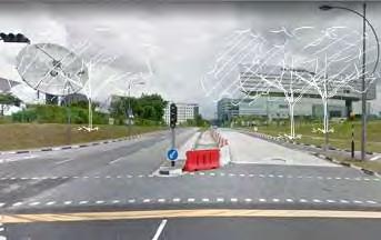
OVERALL ROAD CONNECTIVITY MAP
Potential link into and within one-north Connecting the potential link

Source: https://www.lta.gov.sg/content/ltaweb/en.html
Land Transport Master Plan, 2013, Singapore. https://www.lta.gov.sg/content/dam/ltaweb/corp/PublicationsResearch/files/ ReportNewsletter/LTMP2013Report.pdf
PROPOSED PCN PRIMARY ROUTE SECONDARY ROUTE RECOMMENDATION


GREEN SPACE DEVELOPED PARKS UNDEVELOP PARKS WATER CANAL MRT STATIONS ROAD SYSTEM
PRIVATE LOBBY F&B COMMERCIAL EDUCATION VACANT
GREEN SPACE DEVELOPED PARKS UNDEVELOP PARKS WATER CANAL MRT STATIONS ROAD SYSTEM


LINKING THE KEY NODES OF ONE-NORTH MAKING THE GREEN SPINE A CONNECTOR

46 47
WALKABILITY & CYCLABILITY CONSIDERATIONS
All the considerations are summarized from literature review. Whole studio voted for top 10 from a professional perspective.
1.Continuity And connectivity
Variables Rationale
A- Obstructions (For walking & Cycling) (Cyclability Walkability)
Vote-11
B-Intersections (Cyclability Walkability)
Vote-2
Permanent path obstructions / Obstacles -for walking -for cycling
Suggested Measurement method Reference
The component of connectivity Map out the obstructions: Poles; Signs; Driveway crossover…
-Intersections -Distance walked Intersection density increase the odds of cycling due to increased connections
Proper walking distance encourages walking trips from the property to other destinations Intersection density increase the odds of cycling due to increased connections
Proper walking distance encourages walking trips from the property to other destinations
C-Destinations (Cyclability)
Vote-6
-Connectivity to destinations The greater the number of assessed destinations, the more connected the town
D-Cycling routes proportion (Cyclability)
Vote-9
E-Vertical transport (Walkability)
Vote-0
-Shares of cycling routes relative to total urban network
Provides an understanding of the planned connectivity in the urban area
Count of number of intersections in 400m grid, scored from 1-5, from 0 to >60 intersections
Scored from 1-5, from small block size to big scale block size. intersection in 400m grid, scored from 1-5, from 0 to >60 intersections
Scored from 1-5, from small block size to big scale block size.
(Terri Pikora et al.,2000)
(FCL,2015)
ASpeed limitation (Cyclability Walkability)
Vote-9
Variables Rationale Suggested Measurement method Reference
-Lower speed limits for vehicles
-Traffic calming facilities
-Traffic volumes
A component of safety Reduce the speed of vehicles
Score of 1-5, from 80km/h;60km/h;60km/h;40km/ h30km/h
Count the number of Traffic calming measures.
((Active Living Research,2013) (FCL,2015)
(Thijssen et al.,2000)
(Forsyth Ann et al., 2015)
BStreet parameters (Cyclability Walkability)
Vote-5
Count of number of destinations
Scored from 1-5
(Winters et al.,2013)
(P.P.Koh & Wong,2013)
CLighting condition (Cyclability Walkability)
Vote-3
DSight lines (Cyclability Walkability)
-Separation Path location (how close is the path to the edge of the street/road?)
Record traffic volume on site Score of 1-5 from Little volume to High volume
May out the Separation typeshorizontal/ vertical Estimate the distance between the path and the edge of the road.
Score of 1-5, from Next to More than 3m from kerb
(Terri Pikora et al.,2000) (FCL,2015)
-Lighting cover the path area
A component of sense of safety, also could be a consideration of the safety of riding at night
Does the lights positioned to shine over the path area?
Yes-5 No-1
(Terri Pikora et al.,2000)
A calculation: Total length of cycling routes (km)/total length of urban road network Scored from 1-5
(Winters et al.,2013)
(Council,2000)
(Harbutt & Richardson,2000)
Vote-0
-Good sight lines for users
-Sight lines from others(Street surveillance)
-Proportion windows at street level
Good sight lines increase sense of safety
Windows on the road create surveillance
Score of 1-5, from good sight lines to bad sight lines
Note the proportion of streetlevel façade on your side that is covered by windows of any size.
(Ewing Reid et al,2009) (Forsyth Ann et al., 2015)
-Vertical transport A component of connectivity Map out the vertical transport, account the number and scored from 1-5
F-Continuous Greenery -Connected greenery in cyclists’ view
A component of connectivity Continuous canopy, and more continues shrub and groundcover greenery continuing in 8-10s.
(FCL,2015)
EPerceived and actual crime figures (Cyclability Walkability) Vote-0
-Perceived and actual crime figures
A component of sense of safety
Research online (Forsyth Ann et al., 2015)
(Lu yu etal,2018)
48 49
WALKABILITY & CYCLABILITY CONSIDERATIONS
5.Health Engagement
Variables Rationale Suggested Measurement method Reference
Health engagement (Cyclability Walkability)
Vote-1
Greenery scenarios (Cyclability Walkability)
Vote-4
Noise level (Walkability Cyclability)
Vote-1
Air pollution (Walkability Cyclability)
Vote-0
Number of cycling health facilities Transit-oriented communities increased physical fitness and mental health.
Greenery scenarios on the both side
Count the number of cycling health engagement facilities, score from 1-5
6.Attractiveness
Proportion active uses (Cyclability Walkability)
Vote-0
Variables Rationale Suggested Measurement method Reference
-Presence of outdoor dining
-Cultural activities, Recreational walk
-Number of people
Engagement(Related to Transparency)
Count the number of outdoor tables for dining on your side and within the study area.
Record the number of tables you count.
(Ewing Reid et al,2009)
Noise level A component of comfortability
Providing parameters: Scored by: reservoir, park, playground, lake -7 points, tree alongside- 5 pints,nil-0 points
& Wong,2013)
Air pollution Air pollution can be related with respiratory conditions and cancers
Measure in noise tester/ Walk down the block at a reasonable pace.
Evaluate the level of noise
(1=very quiet, 2=quiet, 3=normal, 4=loud, 5=very loud).
Record your noise level rating.
Score 1-5
Evaluate base on the number of traffic volume scores; factory number; burning activities
Environment color (Cyclability Walkability)
Vote-2
Environmental friendly design (Cyclability Walkability)
Vote-2
Social interaction (Cyclability)
Vote-0
Population increase of this block (Walkability)
Vote-11
-Number of basic building colors (both sides, beyond study area)
Engagement(Related to Complexity)
-Design working with natural systems Integrate nature into our transportation networks, reaping the benefits of ecosystem services while minimizing conflict between humans and wildlife.
Note the amount of active-use buildings that are on your side within the study area. If a building is active, assume all sides are active (even blank walls).
Count the number of basic building/structure/surface colors on both sides of the street within the study areas. Do not distinguish between different shades of the same color.
Record number of distinct building colors.
Count the number of environmental-friendly designcapture and filter storm water, reduce flooding, support pollinator species, strengthen biodiversity, and protect wildlife populations.
-Social interaction Engage riding Measure the width of cycle paths, is it wide enough to accommodate 2 cyclists
-Population increase of this block
6.Attractiveness
Scenery features (Cyclability Walkability)
Vote-9
Variables Rationale Suggested Measurement method Reference
-Number of courtyards, plazas, and parks
-Proportion historic building frontage
-Number of buildings with identifiers
-Number of major landscape features
-Number of pieces of public art
Good scenery as a pull factor that attracts people to cycle
Engagement(Related to imageability; Human Scale; Complexity )
Based on mapping and site visiting
Score from 1-5 for the amount of variables 1-6, divide 5 at last
(P.P.Koh & Wong,2013) (Ewing Reid et al,2009)
Reference:
Engagement- an indicator of better urban areas that attract redevelopment
(Ewing Reid et al,2009)
(ASLA,2018)
(Paige Willis et al.,2013)
Research online (Forsyth Ann et al., 2015)
1. (FCL,2015)Modelling for Walkability Understanding pedestrians’ preferences in Singapore, FCL
2. (Ewing Reid et al,2009)Ewing, Reid, and Susan Handy. “Measuring the Unmeasurable: Urban Design Qualities Related to Walkability.” Journal of Urban Design, vol. 14, no. 1, 2009, pp. 65-84.
3. (Forsyth Ann et al., 2015)Forsyth, Ann. “What is a Walkable Place? The Walkability Debate in Urban Design.” URBAN DESIGN International, vol. 20, no. 4, 2015, pp. 274-292.
4. Cherlyn Lim Li Xuan (MLA class 2016) , Assessing connectivity for a seamless cycling experience in the Tampines intra-town cycling network, 2015–2016 (Accepted for presenting GASS conference 2016)
5. (Active Living Research,2013)Active Living Research-How to Increase Bicycling for Daily Travel
6. (Terri Pikora et al.,2000)SURVEY OF THE PHYSICAL ENVIRONMENT IN LOCAL NEIGHBOURHOODS SPACES INSTRUMENT: OBSERVERS MANUAL
7. (Paige Willis et al.,2013)Paige Willis, Devon, Kevin Manaugh, and Ahmed El-Geneidy. “Uniquely Satisfied: Exploring Cyclist Satisfaction.” Transportation Research Part F: Psychology and Behaviour, vol. 18, 2013, pp. 136-147.
8. ALSA https://www.asla.org/land/LandArticle.aspx?id=54024
52 53
(ASLA,2018)
(FCL,2015)
(P.P.Koh
(FCL,2015)
(ALSA,2018)
DESIGN GUIDELINES FOR CYCLING IN RELATION TO HEALTH
Physical Heath Aspect
Traffic safety
Goal - Safe network for commuters
Space away from traffic
Element Rationale Assessment Criteria Reference
Pollution Source
Goal - reduce negative influences affecting health
Element Rationale Assessment Criteria Reference
Width between cycling routes & pathways i
To reduce the likelihood of collisions with turning around vehicles
Cycle lanes and tracks at least 2.1m wide, away from traffic, make cycling convenient and sociable.
Chartered Institute of Logistics and Transportation, 2010
Sunlight Overheat Locate seatings & overhead protection in areas of maximum sunlight to maximise comfort level
Creating sun traps - areas surrounded by walls with an orientation toward the south (walls should not block plaza/street visibility).
OECD, 2013
Not mixed with pedestrians Clarity on road usage between pedestrian & riders
Layout of carparking Parking bays : between the cycle track & the traffic lanes
Minimize road width Shorter crossing distance
Distinction between footpath & cycle track
Overlapping with pedestrians
Score - 1
Clear distinction between 2 commuters
- Score - 2
Location of car parking & pathway to avoid possibility of traffic
injury
Minimize road width to reduce traffic speeds & pedestrian crossing to encourage continuous commuting
Width of 2.5m avoids the problem of ‘dooring cyclists by parking cars’.
Narrower width
50cm buffer zone
Minimum road width : up to 2.9m
Score - 1
Below 2.9m
Score - 2
Chartered Institute of Logistics and Transportation, 2010
Chartered Institute of Logistics and Transportation, 2010
Land Transport Authority, SG
Wind Comfort Downdrafts from surrounding high-rise buildings can cause user discomfort and should be prevented or reduced through specific design measures
Weather Experiential Promote usage of connecting places through cycling by providing shelters in case of weather changes.
Noise Hearing Avoid ‘stop-dismount-push’ interruption to maintain momentum
Avoid large, open, unprotected areas
Score
Avoid wind funnels: narrow openings between buildings with easterly or northwest alignment
Utilize planting, low walls and canopies for wind deflection.
Undisturbed by drastic weather changes(Score - 4)
Relatively cooling zone(Score 3)
Heat-prone area(Score 2)
Rain-prone area(Score - 1)
Install signs and calories notice board along the cycling path to motivate continuous cycling.
Cycle tracks along a road must not give way at every side road or driveway.
Crossings should detect the presence of cyclists, like most traffic lights.
OECD, 2013
Continuity around bus stops
Provision of spaces for pedestrian waiting & exiting bus
Layer separation Hierarchy of footpath & cycling tracks
Avoid sudden halt to disconnect cycling flow
Place continuous cycle track away from the waiting area. The layout called ‘floating bus stop’.
Robin Heydon & Martin LucasSmith, 2014
Noise Hearing Reduce negative consequences of noise pollution. Improve conduciveness of outdoor spaces for recreation / community use
Area with natural vegetation as buffer 15m wide, (Score 3)
WHO, 2011
Robin Heydon & Martin LucasSmith, 2014
Speed limit up to 30mph
Avoid stop start
manoeuvre
Relation to metabolic rate while cycling
Clearly define cycle tracks for smoother journey
Cycle tracks higher than road surface but lower than footway
Chartered Institute of Logistics and Transportation, 2010
Health benefits gained from physical activity. 15km/hr for traditional bicycles, 22+km/ hr for pedelecs. Metabolic output similar.
Cycle infrastructure Avoid ‘stop-dismountpush’ interruption to maintain momentum
Install signs and calories notice board along the cycling path to motivate continuous cycling.
Cycle tracks along a road must not give way at every side road or driveway.
Crossings should detect the presence of cyclists, like most traffic lights.
Lenten & Stockmann, 2010
Robin Heydon & Martin LucasSmith, 2014
Day Medical Services /Health
Promotion Services
Holistic healthcare
Health education hubs, Active SG sports complex, Health information centre, Neighbourhood clinics
Encourage widespread usage of public health services
Healthcare institutions at neighbourhood
Tan P.Y., Liao K.H., Hwang Y.H., Vincent C (2018)
Ministry of Health, 2018
54 55
Neighbourhood
THERMAL COMFORT MEASUREMENT THERMAL COMFORT MEASUREMENT
Understanding Thermal Comfort Measurement Methodology COMPARISON
THERMAL COMFORT MEASUREMENT Variables Direct MeasurementIndirect Measurement

UTCI PMV STEVE(NH WONG) TSV(Terrace TAN) TSV(WEI Yang)

Reference:
Reference:
1) YANG WEI (2013-03-22). Outdoor Thermal Comfort in Urban Spaces in Singapore. ScholarBank@NUS Repository

2) Honjo, Tsuyoshi, et al. “Thermal comfort along the marathon course of the 2020 Tokyo Olympics.” International journal of biometeorology (2018): 1-13
3) Wong, NH. and Jusuf, SK. (2013). Urban Heat Island Mitigation Strategies at City and Building Level. In: Kolokotsa, D., Santamouris, M. and Akbari, H. (Eds.) Advances in the Development of Cool Materials for the Built Environment, page 3 – 32. Bentham Science Publisher.
4) Thermal Comfort + Landscape Design Optimization by Dr. Tan Chun Liang
1) YANG WEI (2013- 22). Outdoor Thermal Comfort in Urban Spaces in Singapore. ScholarBank@NUSRepository
1) YANG WEI (2013-03 22). Outdoor Thermal Comfort in Urban Spaces in Singapore. ScholarBank@NUSRepository
2) Honjo, Tsuyoshi, et al. "Thermal comfort along the marathon course of the 2020 Tokyo Olympics." International journal of biometeorology (2018): 1
2) Honjo, Tsuyoshi, et al. "Thermal comfort along the marathon course of the 2020 Tokyo Olympics." International journal of biometeorology (2018): 1
3) Wong, NH. and Jusuf, SK. (2013). Urban Heat Island Mitigation Strategies at City and Building Level. In: Kolokotsa , M. and Akbari, H. (Eds.) Advances in the Development of Cool Materials for the Built Environment, page 3 32. Bentham Science Publisher.
3) Wong, NH. and Jusuf, SK. (2013). Urban Heat Island Mitigation Strategies at City and Building Level. In: Kolokotsa , M. and Akbari, H. (Eds.) Advances in the Development of Cool Materials for the Built Environment, page 3 32. Bentham Science Publisher.
4) Thermal Comfort + Landscape Design Optimization by Dr. Tan Chun Liang
4) Thermal Comfort + Landscape Design Optimization by Dr. Tan Chun Liang
58 59
Variables Direct MeasurementIndirect Measurement WBGT
Air Temperature (℃) √ √ √ √ √ Mean Radiant Temperature (℃) √ √ √ √ Relative Humidity (%) √ √ √ √ Wind Speed (m/s) √ √ √ √ Clothing Level (m2K/W) √ Metabolic Rate (J/s) √ Water Vapor Pressure (kPa) √ Built Environment (m) √ √ √ Green Plot Ratio (%) √ Sky View Factor (%) √ √ √ Solar Radiation (W/m² ) √ √ √ Percentage of Hard Paving (%) √ Individual Factor Greenery Physical Condition Greenery Weather Condition
TSV range Air Temperature range (°C) Thermal Perception (Referenced to ASHRAE 7-point scale) -3 to -2 Not applicable Cold to Cool -2 to -1 22.4 - 25.4 Cool to Slightly Cool -1 to 0 25.4 - 28.5 Slightly Cool to Neutral 0 to 1 28.5 - 31.6 Neutral to Slightly Warm 1 to 2 31.6 - 34.7 Slightly Warm to Warm 2 to 3 34.7 - 37.7 Warm to Hot
WBGT UTCI PMV STEVE(NH WONG) TSV(Terrace TAN) TSV(WEI Yang) Air Temperature (℃) √ √ √ √ √ Mean Radiant Temperature (℃) √ √ √ √ Relative Humidity (%) √ √ √ √ Wind Speed (m/s) √ √ √ √ Clothing Level (m2K/W) √ Metabolic Rate (J/s) √ Water Vapor Pressure (kPa) √ Built Environment (m) √ √ √ Green Plot Ratio (%) √ Sky View Factor (%) √ √ √ Solar Radiation (W/m² ) √ √ √ Percentage of Hard Paving (%) √ Individual Factor Greenery Physical Condition Greenery Weather Condition
Reference:
TSV range Air Temperature range (°C) Thermal Perception (Referenced to ASHRAE 7-point scale) -3 to -2 Not applicable Cold to Cool -2 to -1 22.4 - 25.4 Cool to Slightly Cool -1 to 0 25.4 - 28.5 Slightly Cool to Neutral 0 to 1 28.5 - 31.6 Neutral to Slightly Warm 1 to 2 31.6 - 34.7 Slightly Warm to Warm 2 to 3 34.7 - 37.7 Warm to Hot
TEMPERATURE SENSATION VOTE RANGE
OF INDEX
HEAT MITIGATION STRATEGIES
Design Measures to Mitigate Heat
SOFT-SCAPE TACTICS | CREATE WIND CORRIDOR
Fully utilize the terrain in existing landscapes to create wind corridor


Guide the wind
SOFT-SCAPE TACTICS | CREATE CONTINUOUS SHADE
Create green street with trees that can provide enough canopies


SOFT-SCAPE TACTICS | REDUCE IMPERMEABLE SURFACE & ENCOURAGE MORE EVAPORATION
Choose right species and create water feature to increase evaporation & retention of moisture
SOFT-SCAPE TACTICS | CREATE GREEN SURFACES
Fully utilize the building coverage to create more green surfaces to optimize microclimate


HARD-SCAPE TACTICS | CREATE CONTINUOUS SHADE
Fully utilize the building overhead and flyover to provide continuous shading

HARD-SCAPE TACTICS | CREATE CONTINUOUS SHADE
Increase shelter on the road & open spaces to provide enough shading


60 61
Reflect Sunlight Create more shade Evaporation Rainwater retention To keep soil moisture Evaporation Evaporation Evaporation Evaporation Reflection Absorb


62 63 CHANGES OF ROAD NETWORK HISTORY OFTHE SITE 1km High Low Buildings Roads 0 1000m 1914 1945 1966 2018
Understanding Current Land Zoning in One-North LANDUSE MAP


LEGEND
Residential Area House Cando HDB
Commercial & Business Service Business Service Shopping mall Industry & Factory Market and Food Centre Food Court Hotel Farm & Nursery


Administration & Public Service Ministry Institute Education and Research Civic and Community Centre Health and Medical Care Sports Centre Culture & Arts Place of Worship
Transportation & Public Infrastructure Train Station Utilities Car Park Shulter & Pavillion Road Line
HDB with Business HDB with Market and food centre
HDB with community centre
HDB with Minstry Institute
Cando with Minstry Institute
Cando with Business Business with Market and food centre Health and Medical Care with food cort

Ministry institute: Administrative office, police station, post office Utilities: Fire station, power station, water station, gas station Culture & Arts: Library, museum, gallery Place of Worship: Mosque, Church, Chinese temple, Hindu temple

500m

64 65
OPEN SPACES
A variety of open spaces have been identified in One North, serving different social function of commuting and gathering, and some parks and green patches also provide environmental functions including microclimate improvement and pollution mitigation. Open spaces are important for cyclability analysis, as they impact the visibility and experience.


LEGEND
Green Patch

Turf with vegetation
Park

Streetscape
Roof Garden
Reserved Turf Land
Manicured Landscape
Public Plaza
Inter-Building Space


Institutional Landscape
Sparse Landscape
Outdoor Eastery
Sports Field


Construction Site
Car Park

Inter-building Spaces


66 67
500m
Green
Streetscape
Garden
Land
Public
Outdoor
Sports
Patch
Roof
Reserved Turf
Manicured Landscape
Plaza
Eastery
Field
Park
Turf with vegetation
VEGETATION CONDITION


68 69
LOW HIGH VEGETATION DENSITY MAP
LEGEND roads railways buildings Terrian elevation(m) 1 1-5 5-10 10-15 15-20 20-25 25-30 30-35 35-40 40-45 45-50 50-55 55-60 60-65 65-70 3.1% 1.4% 3.8% SLOPE(%) 0-5 5-10 10-15 15-20 20-25 25-30 30-35 35-40 40-45 0.3% 2.3% 4.4% 5.6% 2.3% 7.3% 3.1% 1.4% 4.5% 7.3%(CARRIAGE WAY) 0 500
LANDFORM SLOPE
POPULATION DENSITY
General human density map footprint with population


human density heat map_ morninG CommutinG time


General human density heat map

human density heat map_ niGht CommutinG time
70 71
High Low Buildings Roads 0 1000m High Low Building Roads 400m High Low Buildings Roads 0 1000m High Low Buildings Roads 0 1000m Building Roads 400m High Low Buildings Roads 1000m
ACCESSIBILITY ANALYSIS
Analysing
mrt-600m reaCh aCCessibility analysis


72 73
route seleCtion
on UNA
mrt-600m buildinG aCCessibility analysis shortest
Analysis based
Toolbox for ArcGIS and Rhino
20% more shortest route seleCtion Road Road within 600m Building within 600m Building Road Close Far LEGEND Road Route Building Start/End point LEGEND Road Route Building Start/End point LEGEND LEGEND
URBAN NETWORK SYSTEM
Accessibility
in One-North
ACCESSIBILITY ANALYSIS
Analysing Accessibility in One-North

URBAN NETWORK SYSTEM
route seleCtion possibility analysis

mrt entranCe aCCessibility analysis
connection Building
route usaGe analysis - mrt to one north
route usaGe analysis-residential to mrt


74 75 High Possibility
Circulation MRT Station Building LEGEND Road LEGEND Road Accessibility
LEGEND Circulation MRT Station Building LEGEND Low
THERMAL COMFORT ANALYSIS


Understanding Thermal Comfort in One-North

BUILDING HEIGHT AND TERRAIN
TEMPERATURE - AFTERNOON PERIOD
LEGEND Building height + terrain 0
115 m
Measurement points from GPS track

TEMPERATURE - MORNING PERIOD
Time Period: 08:30 to 09:00 11/09/2018
Data : 98 point for temperature (°C)


MAX 30.97 (DOVER) MIN 26.67(DOVER)
MEAN 29.17 MEDIAN 29.07
56 point for wind speed (m/s)
MAX 3.34(WESSEX) MIN 0.25
MEAN 1.01 MEDIAN 1.01
TEMPERATURE - EVENING PERIOD
Time Period: 12:00 to 12:30
11/09/2018
Data : 105 point for temperature (°C)
MAX 32.44 (HOLLAND VILLAGE) MIN 27.53 (COMMONWEALTH)
MEAN 30.07 MEDIAN 30.1
66 point for wind speed (m/s)
MAX 2.01(QUEENSTOWN) MIN 0.25 MEAN 0.71 MEDIAN 0.5
Time Period: 18:30 to 19:00 11/09/2018
Data : 103 point for temperature (°C)

MAX 30.42 (QUEENSTOWN) MIN 27.14(ONENORTH)
MEAN 28.74 MEDIAN 28.57
66 point for wind speed (m/s)
MAX 2.52(ONENORTH) MIN 0.25
MEAN 0.60 MEDIAN 0.50
TSV Value 1 0 0.5
76 77
GREEN SPACE TYPOLOGY & VEGETATION DENSITY


Its relation to health / social facilities
Maximising health benefits through greenery
Green Typology & Social function related space
Grove, Grassland, Greenway
Manicured Landscape, Community Space
Natural Landscape, Park
Lawn, Turf, Sports field
Open Space with less vegetation, Plaza
Vegetation Density
Very Dense
Dense
Less Dense
Spare
Canopy Location
Health Services & Social Services
Fitness Healthy Eateries
Medical Clinic
Pharmacy
Resident Committee
Community Centre
Student Care Centre
Family Services
78 79
500m
HYDROLOGICAL FLOW


80 81
flow and open drainage typology 20m Type A Water flow 0m 500m 3m Type B 1.6m Type C 0.6-0.8m Type D 0.5m Type E LEGEND A: 20m B1: 3m B2: 3m D1:0.6m D2
D2
D3:0.7m D3:0.7m D4:0.7m
D6
D7
D8:0.8m D9
D10
car
D12
Water
next walkway :0.6m
next walkway :0.6m
D5
fence, next building :0.7m
fence, close green patch:0.8m
next car lane:0.8m
next building:0.8m
next
lane :0.8m D11
one north factory area :0.8m
one north factory area:0.8m
E2 Holland village residence :0.5m C2
E3
car lane :0.5m
C1 in green patch :1.6m
next walkway with fence :1.6m
D13 in express way :0.7m
E1
Holland village residence :0.5m
TRANSPORTATION NETWORK SYSTEM


82 83 LEGEND LEGEND ROAD NETWORK AND BUS STOP Bus stop Cycling path Footpath FOOTPATH AND CYCLING PATH
Understanding Accessibility in One-North LEGEND LEGEND CROSSING AND CAR PARK HDB Carpark URA Carpark Crossing Internal Shuttle Bus Route Public Bus Route BUS ROUTE
TYPOLOGIES | ROAD SECTIONS


Understanding Streetscapes of One-North


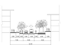
EXPRESSWAY
REGIONAL MAIN ROAD
LOCAL ADDRESSING ROAD 1
84 85
MAIN DISTRICT ROAD
LOCAL ADDRESSING ROAD 2
ENTRANCES & BARRIERS
86 87
leGend Boundary Entrances Physical Barriers Conflict Zones Public Pedestrians All (Cyclist, Pedestrians, Cars) Private Informal Crossings . Marked Non-Signalised
1-7 8-14 15-20
Crossings .
Handicap
(
Ramp . Lift ) Pedestrian Bridges . Bus Stops (without cycling lanes) . Kerbs . Staircases ( Low . Med . High )
BARRIER TYPOLOGIES
Barriers where cyclist momentum is affected / disrupted = dismount = loss / decrease of momentum

Pedestrian Overhead Bridges
Pedestrian Overhead Bridges without wheeling ramps, cyclists have to carry their bicycles up the bridge. Pushing devices across the overhead bridge
Bus Stops
Certain bus stops has an additional space for cyclist usually located at the back of the bus stop, to provide seamless flow for cyclist to avoid collision with passenger boarding / alighting / waiting for buses
14 - 20 steps
Staircases
8 - 13 steps
When a cyclist encounter a staircase, one would have to dismount & carry it down, before cycling again to their destination
1 - 7 steps
Informal Crossings
Found in junctions where a footpath or cycling path intersects with a road. Common types of informal crossings include car park accesses, and minor road junctions within neighbourhoods which do NOT have any indication or marking
Cyclists should slow down and keep a look out for the crossing ahead and also look out for approaching vehicles
Marked Non-Signalised Crossing Kerbs
This could be a small factor, one could argue that it’s’ easy for cyclist to ride over / up onto a kerb.

But it’s still requires a certain group of cyclist to dismount & overcome the kerb. It’s also a barrier which affects one’s speed when cycling
Zebra crossings, are indicated by thick solid white lines on the road
Cyclists should stop and look out for approaching traffic before crossing the road at walking speed
88 89
with lanes without lanes
HIGH MED
LOW
Pedestrian and Vehicular Traffic comes into contact
SURVEY METHODS
Site Survey Process

No. of Surveyors : 12
No. of Response : 288
Date and place of Survey Conducted :
25 / 8 / 2018, Saturday - Ghim Moh, Holland Village, One-North/Bouna Vista, Ayer Ryah and Mount
27 / 8 / 2018, Monday - Ghim Moh, Holland Village, One-North/Bouna Vista, Ayer Ryah and Mount (Morning to Evening)
3 / 9 / 2018, Monday - Dover MRT, Bouna Vista MRT, One-North MRT (Evening)
90 91


92 93
Cyclist Information NON - CYCLIST INFORMATION SURVEY LOCATIONS
of survey conducted LOCATION OF SURVEYEES’ DEPARTURE AND ARRIVAL DESTINATIONS
SURVEY RESULTS
Location
PROPOSALS
TEAM 1. MAJOR DESTINATIONS
A. Buona Vista MRT Junction_Wang Hanfeng

B. Siemens Medical Factory_Xu Yuexin
C. JTC Launchpad_Yong Keng-Whye, Raymond
D. Commonwealth MRT_Kong Lingchang
TEAM 2. COMMUTERS WITHIN THE DISTRICT
E. Ghim Moh Cycling Estate_Kuan Wai Tuck Victor
F. New Cycling Town in Ghim Moh_Liu Xiaolei
G. Freely Cycling Through Indoor and Outdoor_Xu Linxin
H. Intra-Connecting Belts_Yao Haomu
TEAM3. LONG-DISTANCE COMMUTERS
I. Inter-town Spine in Commonwealth Avenue_Wang Zhe
J. Cycling in Green along Dover Road_Lam Si Yun Swan
K. Cycling Loop in One-North_Gao Chenchen
L. Cycling Network for New Development_Fan Lei

95
MOBILITY HUB
Reshaping the Major Destination to Promote Everyday Cycling
A Mobility Hub is a future destination for Everyday Cycling in Singapore. It aims to provide a focal point in the existing mobility network by delivering ease in the fluctuation of transportation systems with densified multifunctions and facilities which will encourage commuters to adopt cycling and cultivating a Cycling Culture. One-North, as a built business hub dominated by 70% of business workers, requires a cycling system or framework that offers more diverse and viable mobility choices to accommodate all commuters.
4 Major Destinations namely - Buona Vista MRT junction, Commonwealth MRT, JTC Launchpad, and Siemens Medical factory were strategically identified as key destinations and selected as design sites based on commuting demand factors regarding the density of workers population, land usage, and public participation results.
Three strategies had been taken to transform these destinations into a successful Mobility Hub. Firstly, improving the cycling mobility and accessibility by proposing alternatives access points to destinations to achieve better perimeter control and strengthen cycling systems. Secondly, considering spatial and functional elements by intensifying potential underutilised spaces, and introduce site-specific related programs for commuters demands. Lastly, advocating cycling culture by increasing outdoor cycling programs and activities.
Here are four types of Mobility Hubs:

JTC Launchpad offers a conducive environment and nurturing ecosystem for startups and incubators. The workplace dominated by 2400 workers is continuously innovating, experimenting, and keeping things fun and flexible. By diversifying access points, reducing barriers, expanding common spaces and introducing a ride-thru food court, it aims to strengthen a harmonious system of workers and food places through active mobility, commercial, and recreation.
Buona Vista MRT junction is a complex transportation hub with heavy traffic volume and varied height difference, causing lots of barriers for pedestrians and cyclists. The aim is to make the circulation more efficient and directly by retrofitting and proposing new multi-tiers cycling network system with underutilised and fragmented built structures and semi-open space near the MRT. Siemens is a manufacturing factory which has 7000 blue-collar workers. Currently, the overutilisation of vehicular roads by other mobility groups - pedestrians and cyclists - generate issues that affect the site’s mobility condition. The proposed design aims to transform building and street infrastructures as part of the cycling network. Also, providing standing eating tables, productive fruit trees and in-out exercise track to attract users to commute by bike.
Commonwealth MRT is supposed to the future commuting destination that serves the high commuting demand for commuters from both arriving by train and within the neighbourhood that counters poor existing continuity condition and connects to the surrounding destinations. This project aims to encourage cycling through the transportation destination by retrofitting the existing built infrastructure to be cyclable and intensifying the space to introduce cycling services.
The making of the Mobility Hub is one step towards achieving a cohesive transportation system and allowing people to make choices that are more environmentally sustainable and physically beneficial.
97
Kong Lingchang | Wang Hanfeng | Xu Yuexin | Raymond Yong
THE NATION CYCLING PLAN


million population Cyclists Current & Future Scenario

5.6

What is a Destination
?
; the place where someone is going or where something is being sent or taken

According to 63 surveyees we’ve interviewed in one-north, majority of them highlighted Transport Systems and Workplace such as Offices are their destinations


98 99 7mins 6mins 15mins 2-3mins 2-3mins 10-15mins 7mins 6mins 15mins 2-3mins 2-3mins 10-15mins
2% 112,000 existinG infrastruCture Home Transit Destination Destinations
DESTINATIONS SELECTION
Destinations Selection
What is a Destination?
OUR DEFINITION | DESTINATION
: The places where workers commute to as a part of their daily life route Destinations Selection Result


Major destination: Metropolis & Fusionopolis, Factory, Holland Village, Ghim Moh Market, Tanglin Market

100 101
1501-5000 865-1500 521-864 261-520 89-260 Legend 0-88 Population Density | one north Population Density | Business 66638-257698 17066-66637 4204-17065 867-4203 0-866 Population Density Commercial 27818-107574 7124-27817 1755-7123 362-1754 0-361 Population Density | Survey 28-53 14-28 4-14 1-4 Legend Legend Legend


102 103 Dover Kent Ridge Dover Queenstown Bouna Vista Kent Ridge Holland Village One North Healthintitution Business Commercial Residential Education Institution 71.3% 13.4% 10.2% 3.9% 1.3% O N ENORTH TIMELINE Major Destinatiom WORKERS TIMETABLE Everyday work life Commercial Area Mrt Junction Area (Commonwealth) Factory Area Mrt Junction Area ( Buona vista) Mrt Junction Area One-North Context ONE-NORTH AS AN INNOVATIVE BUSINESS HUB Legend Mrt Station Commercial Business Factory Education Residential and Utility Mrt Route 0m 500m
EVALUATION OF ECOLOGICAL ASPECT


Landscape Cohesion Least Cost Corridors for 10 species and number of destinations served


CONTRIBUTING FACTORS TO CYCLING MOMENTUM


Barriers, Conflict Zones & Land Ownership


104 105
Thermal Confot & Shaded Areas
Starcases Informal Crossing Steep Slope Overhead Bridge & Kerb Bus Stop high Vegetation Density low 0-5 81-120 6-10 11-20 21-25 26-40 41-60 61-80 121-180 181-210 Shadow Range high low Building Hight Total Area of One north: 1165906m² Total Vegetated Area: 404535m2--34.7% 80 45 0 Legend Morning Noon Evening High Low Barrier Land Ownership Informal Crossing Non-signal Crossing Bus Stop Kerb Overhead Bridge Stairs Ministry of Environment and Water Resources JTC Corporation Private Housing and Development Board Ministry of National Development (Nparks) Major Destination One north area 0m 500m
ROAD USAGE FREQUENCY
STREETSCAPE PAVING TOPOLOGIES


106 107 0-100 101-300 301-700 701-1500 1501-5458 5459-10630 10631-16900 Legend Population density High Low Road Usage Section A Section B Section C Section D
Section E
0-100 101-300 301-700 701-1500 1501-5458 5459-10630 10631-16900 Legend Population density High Low Road Usage Biopolis Area Factory Area 0m 500m 0m 500m
BIOPOLIS AREA EXISTING


AREA EXISTING
108 109 37m 11m 13m 23m 13m 10m 12m 26m 10m 15m 10m Legend
Cycling Inteastructure Green Patches Carparts Courtyard Plaza Entrance for Car and Pedestrian Entrance for Pedestrian Pick up Point Canopy Legend Legend Legend Bicycle parking lots Legend 0-1 1-3 3-5 5-8 8-12 12-15 15-18 19-25 26-30 Handicap Overpass Shelter Crossing Elevation and Slope 0m 500m 0m 250m 0m 500m
CONDITION BIOPOLIS
CONDITION


110 111 High Med Low Vehicular Movement
of Open Spaces Pedestrian Shuttle Bus | Route C Bus 91 Route Heavy Vehicles
Typology
CONDITION
CONDITION Private Green Patches Public Green Patches Carparks Courtyard Plaza Boundary Factory | High Volume of Trucks Entrances Level of Conflict Zones Legend Legend
FACTORY AREA EXISTING
FACTORY AREA EXISTING
ISSUE1 | INCONVENIENCE MOBILITY


112 113 Population in Factory: 43063 Avg. Distance: 600m Avg. Commuting Time: 12 min
Area Interval of 91 bus: Avg. waiting time: 7-14 min Siemens Medical factory : Most inconvenient working place
Average Distance in Factory
of Inconvenience
Timber+ Human Flow
Degree
Siemens Medical factory
Population Density 0-100 101-300 301-700 701-1500 1501-5458 5459-10630 10631-16900 Route 1 Route 2 Route 3 Degree of Inconvenience 0 - 1.6 1.7 - 4.8 4.9 - 13.9 14.0 - 52.3 52.4 - 117.5 Bus Station 91 Bus Route Entrance Recording Time: 1:00-2:00pm 5th Oct. Toilet Stage Hawker Stall Sitting Area Human Flow
ISSUE 2 | DISORGANIZED CIRCULATION
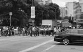


114 115 Car Park Bus stop Car Park Canal Buona Vista Mrt Exit Holland Drive Market Metropolis Drop off zone Greenway 0-100 101-300 301-700 701-1500 1501-5458 5459-10630 10631-16900 Legend Legend Population density High Low Road Usage Selected point Route 1 Route 2 Route 3 Pedestrian Usage Distance Comparison History Map Future Plan Circulation 2000 2003 2009 2016 2018 ISSUE 3 | WEAK LINKAGES ISSUE 4 | DISCONTINUITY Buona Vista Junction Potential Demands 0m 250m 0m 250m
OVERVIEW OF PROJECTS


116 117
A:
B:
C:
D:
Project A: Mobility Hub_Buona Vista MRT Junction


Revitalize Bouna Vista MRT junction as a gateway to activate public cycling willingness.

SITE ANALYSIS

existinG
pedestrain_morninG pedestrain_eveninG CyClist
1. More bicycle facilities are provided: Bicycle Parking lots: 513 Shower room: 22 Water point: 23
Repair point: 17 Washing point: 12 Toilet: 12
2. Created 2700m New Cycling lanes.
3. Provided 72% shaded area for the cycling system.


landsCape performanCe
1. Increased rainwater retention volume: 1512.5m3.
2. Transformed 6780m2 area of grassland into woodland.
3. Reduce Peak Runoff: 9.2%.
1. Health & Welling beings.
2. Recreational & Social value.
3. Scenic quality & Views.
4. Landscape Intervention.


5. Increased accessibility for nature.

119
human
existinG Conditions
Metropolis Railway Corridor Main Point Potential Flow Exist A Exist B Exist C Exist D Holland Drive Market
Vista MRT
flow
Buona
STRATEGY 1: IMPROVING CYCLING MOBILITY AND ACCESSIBILITY BY RETROFITTING AND PROPOSING NEW MULTI-TIERS CYCLING SYSTEM


120 121
New Cycling System Overhead Bridge Plaza Exhibition Platform Jogging Track Multifunctional Open Field
CYCLING SYSTEM & HUMAN FLOW ANALYSIS
NEW
seCtion a-a’
aerial view
MRT Railway Cycling Mobility Hub Southeast Gateway Railway Corridor Rain Garden
STRATEGY 2: MAXIMIZING THE USE OF SPACE FOR INTEGRATING FUNCTIONS BY REDESIGNING UNDERUTILIZED AND FRAGMENTED BUILT STRUCTURES AND SEMI-OPEN SPACE NEAR THE MRT.


122 123 MASTER PLAN a b C
A B C detail plan site C struCture detail plan funCtion site b detail plan site a struCture & system site photos
Human Flow Simulation
the CyClinG journey from one type of works’ perspeCtive


8:40 Leave home to work.
9:00
Arrive at the company and start a day's work.
12:50
Go back to office after lunch.
18:30
Take a shower and have some snacks after exercising on the way back home.
18:00
12:00
Leave office to have lunch.
Leave office and cycle to do exercise before going home.
124 125
Morning
Noon Evening
AIM: REVITALIZE BOUNA VISTA MRT JUNCTION AS A GATEWAY TO ACTIVATE PUBLIC CYCLING WILLINGNESS.


SOUTHEAST GATEWAY &RAILWAY CORRIDOR

126 127 mrt exist b & underGround passinG multifunCtional open field GatherinG plaZa
PROJECT B: SIEMENS MEDICAL FACTORY


Transforming building structure and infrastructure as part of the cycling network


Siemens Medical factory is located in the south part of one-north. There are 7000 workers working in this building which is the most in the factory area. Currently, there are no cycling path around the building. Mixing use of the road such as 91 bus return path, heavy truck, private car and conflicting zone between pedestrian and vehicles will be the periphery issues that affect the cycling.
CONFLICTS & BARRIES
NO TIME AND PLACE TO EXERCISE

7:00 - 8:30
This period is the general start working time and off-duty time. There are three main ways to go to work. One is to take MRT and work to factory, the second is to take the 91 bus, the third is to take Company’s shuttle bus. A large number of workers will buy breakfast in Timber+ and eat at open space around Siemen factory.
12:00-13:00
In this period of time, workers will come to Timber+ to have lunch and have a rest at outside green space.
17:30-18:00
Most of workers will off duty at 17:30, they will stay at the drop off area (in front of the building) and wait for the shuttle bus. During this time, they will chat, eat and rest at the waiting area. Another group of people will go to the 91 bus stop and MRT station to come home.

22:30
This is the starting time for workers who work at night.
129 0m 12m Human Flow Vehicle Flow Cyclist Flow
2. One entrance serves huge number of human flow
3. Different kinds of barries
EXISTING HUMAN FLOW 2 1
1. Informal pedestrian entrance
One-north MRT Bus 91 / Shuttle bus Timber+ Siemens Medical Factory Drop off Area Open Space 3 Workers Timetable
STRATEGY1: MORPHING THE CYCLING NETWORK TO MEET COMMUTERS’ DEMAND AND REDUCE THE CONFLICTS FOR BETTER FLOW


Performance:
1. Three kinds of cycling routes to satisfied commuters’ demands
2. Retrofitting the junction and add one more entrance to reduce the conflicts and serve the large number of flows.


One entrance before
Junction before Junction after Two entrance after
3. Transform the steps to ramp to create coherent cycling
Design Human Flow
Human Flow Vehicle Flow Cyclist Flow
Go across the site Go into the first floor factory Go into the other floor factory
SIEMENS MEDICAL FACTORY MASTER PLAN
Physical Condition
Site area: 17265 m²


Building area: 5850 m²
Shaded area: 5712 m²
Facilities
Shower room: 24
Toilets: 48
Washing point: 5
Repair Tool kit point: 17
Water Point: 23
Function
Green infrastructure


Mobile retail 750 m² recreation area

Information
Health & Well-Being indcator
Legend
Cycling path
Pedestrian
Vehicle lane
Exercise Area
Parking lot
Shower & Washing room
Carica papaya(Papaya tree)
Musa acuminate (Banana tree)
Psidium guajava
133
0m 12m
Performance:

1. Transform hard drainage surface to sofe to create microclimate along the cycling lane


2. 70% paths and open space shaded by vegetation

3. Increase the effective green space from 26.5% to 50%


4. Cycling path temperature reduced by 1.3 degrees (32.9-31.96℃).

134 135
3 m 1.5 m 1 m 3 m 2.5 m 1 m
Water
Cycling
STRATEGY2: CREATING ENVIRONMENTAL FRIENDLY CYCLING INFRASTRUCTURE TO PROVIDE COMFORTABLE CYCLING EXPERIENCE
Planting Area
Way Pedestrian
Path Soft Slope
Original
I. Sofe Surface Drainage Section
drainage
Brush layer
Gabion with Brush Layers Log Cribwall
Gravel Bed Substrate
Wood cribwall built from timber logs Cabion Base
2.5 m
Pervious concrete Wood
II. Intensity Planting Green Street III. Shelter
I. Soft Surface Drainage
Shaded Area (1-3 pm)
II. North Part Entrance
III. Shuttle Area
STRATEGY3: INTERWEAVING OPEN SPACES AND INDOOR COMMON SPACES TO PROMOTE HEALTH RELATED CYCLING CULTURE


TIMETABLE OF EVERYDAY JOURNEY
8:30
8:30
7:00
8:00:
Performance: Help to consume calories
Cycling (moderate) 2 min F: 13cal M: 17cal
Cycling is not only a commute tool but also a good exercise methods. According to the scientific statistics, it can consume 15 calories for 2 minutes.
8:00
7:45
14:30
14:30 17:30
17:30
136 137
7:30 One-north MRT
7:45 Buy breakfast at timber+
Entrance of eating area with standing table and productive planting
Cycling to different floors working place
Exercise at the outdoor cycling track
Waiting the shuttle bus and doing the exercise
Ten floors’ cycling and walking track (15 cal per floor)
OPPORTUNITIES FOR REDEVELOPMENT

The major potential areas are highlight based on entry points, with redevelopment it would improve circulation and reduce conflict points.
PROJECT C: JTC LAUNCHPAD

139
A harmonious system of workers and food place environment
RIDE - THRU JTC LAUNCHPAD Singapore 1st Ride-Thru Gastropark


The workplace dominated by 2400 workers is constantly innovating, experimenting, and keeping things fun and flexible.


140 141
Start
ConCept & interpretation time
RIDE-THRU masterplan leGend 1. One-north MRT 2. Main Plaza 3. Recreation Space 4. Self-Kiosk Plaza 5. Cyclist Court 6. Ride-Thru Market
1 Site 50,000M2 > 150 Companies > 2400 Workers > 1 Gastropark 2200m2
- Ups, Incubators & Accelerators
& aCtivities
RECONFIGURING EXTERNAL & INTERNAL CIRCULATION
Diversifying Entry & Access Points into JTC Launchpad and Office Buildings to improve accessibility and strengthen perimeter control flow map
Studying existing access points into building and site & Analysing existing barriers & conflict areas

Entry Point in/out of Site: 2

Access Points in/out of Buildings: 19
Average Width: 2M
Barriers & Conflict Areas are being resolve through expanding pathways to 6m and creating direct route from one point to another to ease way-finding & efficency.
Entry Point in/out of Site: 5
Access Points in/out of Buildings: 39
Average Width: 3M

142 143
Cyclist Pedestrian Vehicles Access Points Opportunities Conflict & Barriers Bus Stops leGend
BEFORE AFTER
Cyclist Pedestrian Vehicles Access Points Bus
leGend
Stops
MAXIMISING OPEN SPACES

Protuding interal & common spaces into external green spaces, creating multifunctional space
MULTIFUNCTIONAL SHARED SPACE

Stairscases: 17
Cycling Facilities
Unisex Shower Rooms: 52
Total Bicycle Parking: 309m2: 464 Bicycles
Proposed Bicycle Parking: 257m2


Existing Bicycle Parking: 52m2
Self-Kiosk Machines: 43
Bicycle Fixing Kit: 14
Carpark: 211 Crowd
Drinking
18
The safety limits for events are typically assessed at 2 pax per square metre
144 145
Main Plaza Outdoor Collaboration & Refresh Space Recreation & Refresh Space Cyclist Court
Water Points:
2400 Workers Building Infrstructure Lifts: 7
Density
*p = Potential Spaces *1m2 Space = 2pax *1m2 Bicycle Parking = 1.5 Bicycles Existing Bicycle Parking Proposed Bicycle Parking Water Points Bicycle Repair Kit Shower Rooms Self-Kiosk Machines Interior Building Space Potential Spaces Common Spaces Lift Core Existing Green Space Altered Green Space leGend
Types of Recreation & Entertainment Potential Programs in relation to specific site spaces Stage Badminton Basketball Volleyball Futsal Sepak Takraw 0800 - 1000 hrs 1100 - 1500 hrs 1700 - 2000 hrs Programs and activities transcend over different timings study of open spaCes in jtC launChpad
RETROFITTING EXISTING INFRASTRUCTURE

Creating Ride-Thru system in Timbre+ and improve operations efficiency and efficacy
existinG timbre+ & operation serviCes
stall vendor typoloGy loop system
Existing Operating System
Studying space requirements for vendors (serving & cooking)
Proposed Operating System
Stall Vendors Typology could serve as dualfunction


Introducing cycle thru foodcourt incoporated with technology (Self-Order Kiosk) leGend Cycling Lane Cyclist Flow Pedestrian Flow


Programs and activities transcend over different period of time and days. Spaces are flexible and adaptable
multifunCtional spaCe ride - thru Gastropark

Perimeter control in the internal and external spaces of the Gastropark, to provide better operation systems
relationship between Gastropark & offiCes
146 147
A sectional study of how workers moves through spaces from their personal desk to have lunch in Timbre+ Gastropark
PROJECT D: COMMONWEALTH MRT

-A continuous cycling platform for train and neighborhood commuters


AN EXCHANGE STATION FOR WORKING AND LIVING BACKGROUND INFORMATION
To Biopolis Business park To One commonwealth Factory Foodmore food court


Commonwealth MRT is a future commuting transportation destination, serving not only as a transportation hub for the train commuters but also serving as the overhead bridge to get across the Ave to provide access to the neighborhood services. These fragmental public services are attracting the commuters around this area including the workers and residents.

149
1KM
Schools (three schools around this district)
Koufu food court (ground floor of multi story car park)
Soccer Field (valuable open space for the neighborhood)
Tanglin Business(future development)
Buona Vista
MRT
Commonwealth Ave
Commercial services
EXISTING BUILT INFRASTRUCTURE
FLOW/BARRIER IDENTIFICATION


STRATEGY1: INCREASE CYCLING ACCESSIBILITY BY RETROFITTING THE EXISTING BUILT INFRASTRUCTURE

The space inside and outside mrt is quite compact, while the cycling facilities require certain space. The only solution is to fully utilize the existing ground level which has 6 meter height space and part of the second floor's aisle.
Residents Commuting Students Commuting
Cycling Access Toolkits


existing stairs bicycle track
Workers Commuting Workers Commuting
Roof
Level3
Depature floor (9m high)
Level2
Boarding floor (6m high)
Residents Commuting
The existing desin of the mrt entrance direction is mismatching with the actual commuting demands and not friendly to the cyclist due to the elevation difference.
Stairs/ Escalator/Lift (to L2)
Handicap (to Lift)
infrastructure
The design of cycling access ramp depends on the commuting directions, available space and function demands.


Ground floor (0m)
150 151
6.5M 6M 6.5M 6.5M
MRT Entrance 6.5M 6M 6M 0M 5.8M
folded stairs ramp folded ramp light folded ramp curved ramp
elevated lane using exisiting
MRT STATION STRUCTURE
spiral stairs
STRATEGY2: INTEODUCE THE CYCLING FACILITY BY


152 153 6M Seating Area Rest area Way Out Way Out Health Food Shop Cycling Ramp Bicycle Parking Top-up/ ATM Connect to the Business Connect to the Business Cycling Club Rest Area Shower RoomGym Loading Bay Loading Bay Coffee Bar Sports Shopping Mall 6M 3M Seating Area Rest area Way Out Way Out Health Food Shop Cycling Ramp Bicycle Parking Top-up/ ATM Connect to the Business Connect to the Business Cycling Club Rest Area Shower RoomGym Loading Bay Loading Bay Coffee Bar Sports Shopping Mall
6M 6M 3M Connect to the residential Seating Area Rest area Way Out Way Out Health Food Shop Cycling Ramp Bicycle Parking Top-up/ ATM Connect to the Business Connect to the Business Cycling Club Rest Area Shower RoomGym Loading Bay Loading Bay Coffee Bar Sports Shopping Mall 6M 6M 3M Connect to the residential Seating Area Rest area Way Out Way Out Health Food Shop Cycling Ramp Bicycle Parking Top-up/ ATM Connect to the Business Connect to the Business Cycling Club Rest Area Shower RoomGym Loading Bay Loading Bay Coffee Bar Sports Shopping Mall Ground Level Plan Second Level Plan Gym section STAIRS ESCALATOR STAIRS LIFT 6M 6M 3M Connect to the residential Seating Area Rest area Way Out Way Out Health Food Shop Cycling Ramp Bicycle Parking Top-up/ ATM Connect to the Business Connect to the Business Cycling Club Rest Area Shower RoomGym Loading Bay Loading Bay Coffee Bar Sports Shopping Mall MRT Lev1 Toilet: 34 Changing/Shower room: 36 Locker: 200 Gym: 300 m2 Sports Shopping Mall: 800m2 Cycling Club: 640m2 Bicycle Parking: 150+ MRT Lev1.5 Bicycle Parking: 600+ MRT Lev2 Bicycle Parking: 188 Locker: 90 Health Food Court: 885m2 A-A section Perspective C C B-B section Cycling Facilities List A B B A
STRATEGY3: ENCOURAGE THE CYCLING BY DEVELOPING MULTIFUNCTIONAL CYCLING INFRASTRUCTURE

Bicycle Parking
Ground Floor: 517
Platform: 192

Landscape Performance
Elevated infrastructure to minimize surface impact
Fully utilize existing infrastructure

Trees to provide shade for cyclist and pedestrian
Trees provide shade for commercial area
Grass planting parking lots to reduce surface runoff
MASTER PLAN
Water Management
Bioswale Area: 1558m2
Retention Volume: 250m3
Peak Runoff: 58% more capacity
Economic
Rest Seats(commercial): 640
Outdoor Food Stall: 22
Outdoor Commercial Area:849m2
Landscape Performance
Light connction with water
Vegetation material provide thermal comfort

Social resillience
Habitat refugee Tree conservation
Vegetation
Green Plot Ration: 35%(before)47%(after)
Tree Conservation: 95%
Heat Mitigation
Ground Shaded Path: 75%
Elevated Cycling Path: 66%
Landscape Performance
Flexible surfaces encourage activities
Meandered route to slow down the cyclist
Make hole on the roof to conserve the tree trunks
154 A C B 2 1 1.Food stall 2.Food plaza 3.Street seats 4.Grassed bicycle parking 5.Drop off 6.Bus station 7.Street plaza 8.Rain garden 9.Bioswale 10.Coffee bar 11.Elevated cycling lane 12.Landing ramp 13.Elevated platform 6 8 9 4 3 7 6 8 1 10 11 11 12 13 13 13 13 14.MRT station 13 13 12 12 5 5 0M50M
Node A Node B Node C 2 1 1.Food stall 2.Food plaza 3.Street seats 4.Grassed bicycle parking 5.Drop off 6.Bus station 7.Street plaza 8.Rain garden 9.Bioswale 10.Coffee bar 11.Elevated cycling lane 12.Landing ramp 13.Elevated platform 6 8 9 4 3 7 6 8 1 10 11 11 12 13 13 13 13 14.MRT station 13 13 12 12 5 5 0M50M
50m
Landscape Performance
Light connction with water
Surface runoff reduction
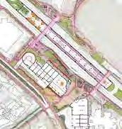
Vegetation material provide thermal comfort


Social resillience
Habitat refugee Tree conservation
Landscape Performance
Flexible surfaces encourage activities

Meandered route to slow down the cyclist

Make hole on the roof to conserve the trees

156 157 Perspective A
Perspective B
Perspective C
a c
b a
Liu Xiao lei, Victor Kuan, Xu Linxin, Yao Haomu
One-north, the high-dense mixed developmental zone has overlooked cycling network to be integrated as part of the development planning due to the segregation of planning phases, ownership and land zoning, resulting to the over-dependence on vehicular transport. This project aims to reduce mobility gaps raised from spatial segregation by means of improving cyclability. Through mobility gap analysis, in broader one-north, Ghim Moh and Biopolis districts are critical zones that have the lowest mobility.
The 4 sections within the mobility gaps are selected through their differences in typology and landuse types – Old Residential Neighbourhood, New Residential Neighbourhood, Business District and intra-connecting belts.
Due to the scarcity of land and the complexity of urban fabric, the conventional way of providing dedicated cycling pathways is not applicable to this project. Instead, there is an opportunity in utilising open spaces to diversify cyclable areas that bridge users to their destination involving their daily needs by providing connectivity, continuity, and comfortability.
Three main strategies are adopted to resolve these concerns.
(1) Diversifying network by enhancing existing flow and venturing alternative linkways by introducing cycling oriented intersection design to reduce walking distance and waiting time; exploring multi-tiered network to active unutilized space interior and exterior open spaces, and active mobility elements to overcome mobile and static obstacles with car-lite intervention and various types of cycling lanes.
(2) Retrofitting open spaces into the multifunctional landscape by leveraging landscape components and modifying topography to expand cyclable space and creating shortcuts along drainage and green corridor, and mitigating heat with landscape and evapotranspiration design.
(3) Facilitating an inclusive cycling community by redesigning amenities with daily needs with cycling-friendly functions such as ride-thru amenities and providing more flexible cycling facilities and planning cycling-oriented guidelines for future HDB and business developments.
This project approaches from the landscape perspective, envisions seamless cyclable spaces for both existing and future residential development to tackle mobility issue and ultimately complementing in the progression of a cycle-friendly and smart nation.

158 159
EVERYDAY CYCLING, EVERYWHERE CYCLABLE
CYCLING AS THE ALTERNATIVE COMPARISON BETWEEN


Are we able to use cycling as an althernative to convert these traveling scenerio?

CYCLING PLANNING FOR ONE-NORTH SINGAPORE CYCLING PLAN


160 161
TRANSPORT
Mode of Transport Per Trip Count (15.6 mil) Main Mode of Transport 31% 66% 1.5% 1.5% 17% 37% 6% 22% 18% Cycle Walk Public Transport Private Vechicle Active Mobility MRT Taxi / PHU Private Vechicle Bus typiCal first and last mile sCenario
MAIN MODE OF
WITH PER TRIP COUNT
Residential (35.1%) Education (30.1%) Business Park (10.5%) Parks (5.0%) Healthcare / POW / (5.0%) Civic Centre Reserve (5.0%) Business (1.6%) Commercial (0.8%) White (4.5%) Commercial and (1.3%) Residential Utility (1.1%) Sport (0.4%) ura masterplan CyClinG time preferenCe of surveyee Less than 15 mins Less than 30 mins Less than 45 mins Less than 1 hr Less than 2 hr More than 2 hr Less than 30 Mins Less than 45 Mins Less than 2 hr More than 2 hr Mode of Commuting Less than 15 Mins Less than 30 Mins Less than 45 Mins Less than 1 hr Less than 2 hr More than 2 hr Less than 15 Mins Less than 30 Mins Less than 45 Mins Less than 1 hr Less than 2 hr More than 2 hr 0 5 10 15 20 25 30 35 40 Mode of Commuting Less than 15 Mins Less than 30 Mins Less than 45 Mins Less than 1 hr Less than 2 hr More than 2 hr 69%
Site Round Island Route Cycling Route Cycling Route Intra-town Cycling Network
CAUSE OF SEGREGATION
CAUSE OF SEGREGATION


162 163 land ownership Private Development Land Transport Authority Housing Development Board
PLANNING PHASES Planned by 1958 Planned by 1980 Jurong Town Corperation Ministry of National Park Development, Ministry of Environment and Water Resources Singapore Land Authority Other Minitries and Authorities
Built by 1914 Built by 1945 Built by 1966 Built after 1966 Loss after 1914 Loss after 1945 Loss after 1966 ONE NORTH BUONA VISTA GHIM MOH HOLLAND DOVER CLEMENTI WEST COAST KENT RIDGE TANGLIN ROAD NETWORK Thick Vegetation Institutional Spaces Park Reserved Turf Turf with Vegetation First-Story Open Spaces ONE NORTH BUONA VISTA GHIM MOH HOLLAND DOVER CLEMENTI WEST COAST KENT RIDGE TANGLIN open spaCe typoloGy Inter-Building Space Planned by 2003 Current Plan Plaza Manicured Landscape ONE NORTH BUONA VISTA GHIM MOH HOLLAND DOVER CLEMENTI WEST COAST KENT RIDGE TANGLIN
MOBILITY FACTORS AND TRANSPORTATION TYPE

MOBILITY BASED ON TRANSPORTATION SHARE PEDESTRIAN NETWORK AND CONNECTIVITY PEDESTRIAN


Pedestrian
Source: https://www.straitstimes.com/singapore/transport/more-opting-to-travel-by-public-transport-survey
HUMAN DENSITY MAP

Compared with public transport and amenity accessibility map to find out the gap areas

With the inclusion of pathways, sheltered walkways and semi outdoor spaces and corridors,areas that are less connected by pedestrians are institutions with security concerns and private developments with minimal access points
SHELTERED - WALKWAY
164 165
CONNECTIVITY MAP
SEMI-OUTDOOR SPACES
Connectivity High Connectivity Search Distance - 400m
leGend Low
Connectivity Active mobility MRT BUS Taxi / Private Hire Car Private Vechicles Traffic Congestion
Amenities Accessibility Public Transport Accessibility leGend
Barriers
IDENTIFYING MOBILITY GAPS
BARRIER MAP
IDENTIFYING MOBILITY GAPS


*Definition of Barrier:
Objects that would affect the speed of walking or cycling Stairs/Ramp/Obstacle/Kerb
MRT Exit/Bus Stop/Building entrance


·Informal/non-signal/signal crossing

leGend Low Connectivity High Connectivity
SLOPE MAP

leGend Low Connectivity High Connectivity
Amenities
leGend
Areas with slope over 8%
166 167
ACCESSIBILITY MAP
AMENITY
Food Court Community Center
School &
Retailing & Shopping Mall
Playground
IDENTIFYING MOBILITY GAPS


leGend
IDENTIFYING THE MOBILITY GAPS
COMBINED
Overlapping of these 5 Mobility Gaps in comparison with existing human density reveal Ghim Moh’s and Holland Close’s neighbourhood to be the least mobile sites within the political boundary of One-North District. Human


168 169
High Congestion Area Low Congestion Area High Congested Road Low Congested Road
TRANSPORT ACCESSIBILITY MAP
Transport Routes Public Transport Stops
Low Connectivity High Connectivity
PUBLIC
Public
leGend
ConGestion map
traffiC
Density Map
Congestion Amenity Accessibility Barrier
Accessibility
Transport Accessibility
Traffic
Pedestrian
Public
MOBILITY GAP MAPPING 500m LEGEND Mobility Gap
SITE SELECTION
IDENTIFYING LAND USE ZONES IN RESPONSE TO IDENTIFIED MOBILITY GAPS


OPEN SPACES AS OPPORTUNITY
CURRENT CYCLING SPACE
Cyclable space
Footpath: 137103m2
Plaza: 684350m2
first floor open space: 20.1%
This industrial area is mainly occupied by shipyards. The percentage of openness is about 80% and the buildings in this area are bigger but more concentrated. So it has a larger and more integrated open space for redeveloping. This industrial area is mainly occupied by shipyards. The percentage of openness is about 80% and the buildings in this area are bigger but more concentrated. So it has a larger and more integrated open space for redeveloping.
ComparinG with CopenhaGen
Population: 583525
Area: 88.25 km²
Density: 6612ppl/km²
Ratio of Total Area to Total Cycling
Distance: 1km²= 4.71km
Population of Residents: 137990 approx
Area: 20.43 km²
Density: 6754ppl/km²

Ratio of Total Area to Total Cycling
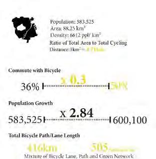
Distance: 1km²= 1.92km
Commute with Bicycle Commute with Bicycle
36% 50% X 0.3
Population Growth X 2.84
583,828 600,100
Total Bicycle Path/Lane Length
416km 505 cycling per km
Mixture of Bicycle Lane, Path and Green Network
Population Growth
1.5% 4.5% X 0.3 X 0.11
5,607,000 6,231,082
Total Bicycle Path/Lane Length

230km
365 cycling per km
X 3.04 700km
401 cycling per km
Source: datasource reference
170 171
500m 500m Cyclable open space
OPEN SPACES AS OPPORTUNITY
CYCLABLE OPEN SPACE TYPOLOGY


This industrial area is mainly occupied by shipyards. The percentage of openness is about 80% and the buildings in this area are bigger but more concentrated. So it has a larger and more integrated open space for redeveloping. This industrial area is mainly occupied by shipyards. The percentage of openness is about 80% and the buildings in this area are bigger but more concentrated. So it has a larger and more integrated open space for redeveloping.
OPEN SPACES AS OPPORTUNITY

DIVERSIFYING CYCLING SPACES

Current cyclable space:9.29%
Pathway:8.7%
Sheltered walkway:0.58%
Potential cyclable space:36.49%

Lawn:27%
Plaza:6.75%
First story open space:2%

Dense vegetation:19%
Building and vehicle lanes:35%
Current cyclable space:13%
Pathway:11%
Sheltered walkway:2%

Potential cyclable space:40%
Lawn:31%
Plaza:9%
Non-cyclable space:54.22% Non-cyclable space:48%
First story open space:0.2%
Dense vegetation:25%
Building and vehicle lanes:23%

172 173
500m 500m
Najas
GHIM MOH
500m
500m
ONE-NORTH
Dense vegetation
Paved without shade
Sheltered walkway
First story open space
Lawn
Paved without shade
500m
WHAT PREVENT PEOPLE FROM CYCLING
SITE SURVEY RESPONSES


Experience
Consistency of Momentum

Way-Finding
Engagement while Travelling
Connectivity of Route
Availability
Bicycle Infrastructure
Bicycle Facilities

Safety
Obstacles and Hazards
Bicycle facilities and Infrastructure Conditions


Personal Confidence in Cycling
Vehicular Congestion

Pedestrian Congestion
Bike path / Lane Dimension


Comfort
Thermal Condition
Overcoming Slopes, barriers

Paving
Wind
Shaded walkway


Satisfied Neutral Unsatisfied
Non-Cyclist Pool
174 175 Residential :old hdb area Residential :new hdb area Commercial: one-north site issues
Cyclist Pool Connectivity Continuity Comfort Attractiveness
WHAT PREVENT PEOPLE FROM CYCLING FLOW MAP (CONNECTIVITY)


BARRIER MAP (CONVENIENCE)
SHADE MAP (COMFORT)
AMENITIES MAP (ATTRACTIVENESS)
176 177
LEGEND Vechicular Flow Pedestrian Flow LEGEND Eateries General Shops LEGEND
Glossaries Store Elderly corner, Elderly care Child care, Pre-school LEGEND Shaded Area 500m 500m 500m 500m
Obstacles (Stairs and Columns) Mobility Aidding Element (Ramps)
PROPOSED OVERALL MASTERPLAN


DIVERSIFYING NETWORK
SMART AND CYCLABLE NATION
INCLUSIVE CYCLING COMMUNITY
RETROFITTING OPEN SPACES INTO MULTIFUNCTIONAL LANDSCAPES
178 179
1 2 3 TOWARDS A CYCLABLE DISTRICT
EXISTING OPEN SPACE USAGE


Ghim Moh Estate, an aging neighbourhood resides with a substantial amount of non-working populations - kids and elderly- that struggle to overcome many existing obstacles such as stairs and kerbs that are made to bridge the elevation differences.


Hence, these factors contribute to the poor mobility of the users, challenging them on a to pursue their daily needs.

PROPOSED OPEN SPACE USAGE
Proposed Site Condition
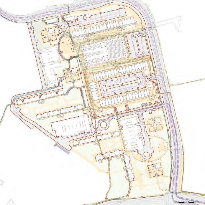

Cyclable Space Active Mobility Elements


3 desiGn interventions transform infrastruCtures to transitional spaCe repurpose linkways as alternative routes leveraGe topoGraphy for elevation advantaGe


Stairs (Obstacles) Ramps (AME) Shelter

180 181
Current Site Condition existinG flow map Comfortability Ghim Moh Market is often visited during lunch hours especially by workers in OneNorth whom are equipped with umbrella to avoid the harsh sun due to the lack of shade ConneCtivity ConvenienCe attraCtiveness The designated circulation flow does not complement the existing human flow
Many commuters are required to cross a series of obstacles to cross from the different entrance points to the center of the Ghim Moh Neighbourhood
site issues
envisioned flow map
Cycling Flow Legend: Pedestrian Flow Vechicular Flow Due to the abundance of mobile and static obstacles and lack of cycling oriented facilities, Ghim Moh Estate is deem to be unattractive to the cycling community
Obstacles Cycling Flow Legend: Pedestrian Flow Vechicular Flow Cyclable Space Active Mobility Elements Obstacles
STRATEGY 01
Diversifying Network DESIGN TACTICS
Identifying Topography and Obstacles Introducing Cyclable Ramps by Leveraging Existing Topography
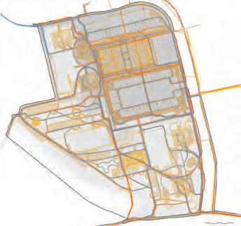


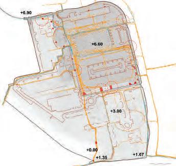
Key Map


STRATEGY 01
Diversifying Network DESIGN TYPOLOGIES
Entrance (Major Conflict Point)
Legend:
1/2
HDB Types
Ramps
Mobility Aiding Stairs

Major Conflict Point (Vechicle and Pedestrian)

Type 2 - HDB Slab Block
Destination 1
Landscape Performance
No. of Main Obstacles: 8
Overall Elevation Difference: 6.9m
Average obstacles encountered per trip: 4
Landscape Performance
No. of Main Ramps on Site: 4
No. of Main Ramps Increased: 6

No. of Main Obstacles Overcame: 6
Bridging Disconnected Sheltered Walkway and Repurposing Existing Infrastructure Exploring Alternative Cyclable Spaces
Cycling Flow
Type 1 - HDB Point Block
Cycling Friendly Ramp
Landscape Performance
Percentage of Shelter Increased: 30%
Percentage of Sheltered Walkway: 33%
Landscape Performance
Percentage of Cyclable Open Space Increased: 66%
Distance of Trip Decreased on Avg: 17%
Mobility Aiding Elements
Destination 2
182 183
1 2
STRATEGY 02
Retrofitting open spaces into the multifunctional landscape CURRENT SHADE AND THERMAL CONDITION

STRATEGY 02
Retrofitting open spaces into the multifunctional landscape PROPOSED HEAT MITIGATION STRATEGIES


Landscape Performance
23% Unshaded Open Space
Most Heated Zone: Ghim Moh Market
Cause of Heat Radiation:
Insufficient Canopy, Reflective Material, Non-porous surfaces
DRY DETENTION PLAZA (SECTION A-A’)
Landscape Performance
More than 25% of Shade Increased
Less than 5% Unshaded Open Space
DESIGN TACTICS:
1 Providing Green Shady Walkway
2 Integrating Cyclable Features on Existing Landscape Infrastructures


3 Designing with Evaportranspiration Process
PLANT PALETTE FOR HEAT MITIGATION:
Native Tree Species with Wide Canopies:


Plant Species for Bioswale:


184 185
Shaded Area Unshaded Area Existing Trees Water Channel Vegetation Proposed Trees Legend: Shaded Area Initial Unshaded Area Existing Trees Water Channel Vegetation Proposed Trees Legend:
Chrysophyllum cainito L.
Hopea odorata
Syzygium grande Syzygium pycnanthum Tabebuia rosea
Cymbopogon citratus chrysopogon zizanioides
Arundo donax
A A’
Wedelia trilobata Pennisetum alopecuroides Ipomea pes caprae
STRATEGY 03
Facilitating an inclusive cycling community
Ghim Moh Cycling Estate : Cycling without Age PROPOSED MASTER PLAN BIKE-TRHU MARKET


186 187
Ride-Thru Bus Stop Ghim Moh Ride-Thru Market Eateries / Food Court Grocery Stores Mixed-Use HDB (BLK 21) Senior Resident’s Corner Pre-School Cycling Playspace Playgrounds Fitness Corners Outdoor Carpark Indoor Carpark Bus Terminal Legend:
VISION
GHIM MOH CYCLING MARKET
1 2 3 4 5 6 7 8 9 10 11 12 13 Overall Landscape Performance No. of Main Ramps Increased: 6 No. of Main Obstacles Overcame: 6 Percentage of Shelter Increased: 30% Percentage of Sheltered Walkway: 33% Percentage of Cyclable Open Space Increased: 66% Distance of Trip Decreased on Average: 17% Average Obstacle Encountered After Proposal According to Main Flow: 0 More than 25% of Shade Increased Less than 5% Unshaded Open Space No. of Bike-Oriented or Friendly Amenities Increased: 9
4
Destination
CYCLING EXPERIENCE
CYCLING EXPERIENCE


188 189
Cycle-thru HDB JUNCTION EXPERIENTIAL SECTION B-B’ Car-lite Zone Cyclable Lawn First Floor Open Space Sheltered Shared Pathway Elevated Bike-Thru Ramp Bike-Thru Green Way Bike-Thru Ghim Moh Market Located at non-traffic heavy roads Grass covered with Ground Protection Mesh From destination to a transitional space 4.5 -3.5m provided shared path with utilisation of landscape infrastructure 1:15 ratio ramps to facilitate better mobility experience Clutter free zone to reduce obstruction when travelling Integrating cyclist as part of pedestrians PAVEMENT PLAN
Experiential
Experiential Cycle-thru B’ B 1 2 3 4 5 6 7 Main Cycling Flow w/ No obstacles Main Cycling Junction CYCLING JUNCTION Destination 5 1 3 2 6 7 Permeable Concrete Paving Ground Protection Mesh EPDM Cyclable Zone Pervious Concrete Slab Elevated Mesh Flooring Pervious Cycling Lane Metal Mesh Drain Cover ROAD TO PATH JUNCTION Main Destination 4 5 Destination 6 Destination 7
PROJECT F: NEW AGE CYCLING TOWN IN GHIM MOH

Site Introduction: New type of HDB with high rise building
Next to the park connector . A bridge connect this area and ghim moh market
Continuity:
-Stable obstacle: this site does not have many stairs, the problem is column of shelter, curb of car lane and each residential building -Movable obstacle: cluster of people at bus stop, market, food court -The conflict between cars and pedestrian walking in the first story of multi-layer car park


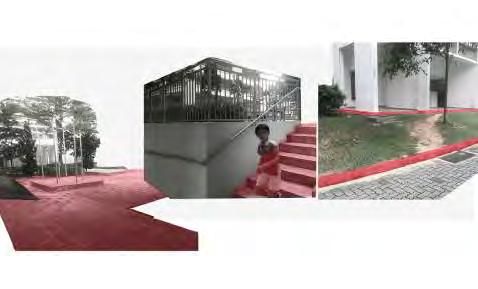

Comfortability :the residential are quite good .the main road lack of shade.
Continuity: Considerable short-cut in green space.
Attractiveness: Attractive space with low accessibility. High accessible not less attractive

Vehicle flow
Human flow
190 191
issue 500m


192 193 after after before DIVERSIFY THE FLOW before CYCABLE SPACE:
Cycable space Vehicle flow Cyclist flow Pedestrian flow YOUNG COMMUNITY CULTIVATION master plan 6 6 3 4 5 8 8 1 7 7 2 1 4 12 11 10 13 9 9 2 14 17 18 15 16 1 cycling playground 2 Fitness corner 3 Outdoor restaurant 4 Foodcourt and shop 5 Grass bricks 6 Plaza 7 Car Lite area 8 Rain garden 9 Precinct pavilion 10 Community centre 11 First floor of multi-story car park 12 Non-cycable space at first floor (grey colour) 13 Fitness playground 14 Community garden 15 Bridge to ghim moh market 16 Platform with facilities 17 Observation point 18Canal 500m
FROM 2% TO 10%
STRATEGY 1 DIVERSIFYING NETWORK


194 195 retrofittinG existinG shelter 2.5m 1.2m 0.3m 3.1m 0.6m dediCated CyClinG route Increased cycling space car-lite area The area of increased cycling space: 400% The percentage of fist story of multi-story car park changed to the cycling friendly space: 80% The percentage of carlie area of the whole service road: 54% The percentage of the road with cycling friendly shelter: 15% Removed obstacles: 70% Vehicle flow Cyclist and pedestrian flow Cycling ramp Existing flow Additional flow
LANDSCAPE PERFORMANCE
Introducing cycable space Car-lite area before after reshapinG the first floor of multi-story Car park Vehicle flow Cyclist and pedestrian flow removinG existinG barriers Cluster of people hdb buildinG before after before after before after Cycling ramp Existing flow Additional flow
STRATEGY 2 MULTIFUNCTIONAL LANDSCAPE
Modifying topography to increase vertical cycling layers

Connect HDB residence to the park connector

Connect HDB residence to the opposite area all the way to Ghim Moh market


Section A-A
Creating cycling routes along drainage


Heat mitigation
STRATEGY 3 FACILITATING AN INCLUSIVE CYCLING COMMUNITY
Cycling through daily amenities
Cycling facilities at each building
Bioswale for evaporation:850m
LANDSCAPE PERFORMANCE
The percentage of sheltered road:72%
2 Cycling facilities
Sheltered road
196 197
10m 10m 9m 9m 8m 8m 7m 6m 5m 4m 3m A A Car park Community centre Fitness corner Cycling playground Precinct pavilion
CYCLING EXPERIENCE


198 199
1 Naturalized drainage 2 Observation point 3 Secondary forest 4 Percent pavilion 5 Fitness corner 6 Community garden 7 Plaza 8 Food court and retail 9 Community centre Cycable space Parking and facilities 1 2 3 4 5 6 7 8 9 attraCtiveness key destinations A B C D F E A Along drainage B Across canal C Secondary forest D First floor of multi story car park F HDB estate E Car-lite area Shade Wind corridor Cooling pavement by painting in light colour Evaporation` Vertical layers Barrier free area Active mobility centric Signage Zebra crossing Painted cycling route Parking and Repairing space Natural views Observation point Street furniture integrated with bike parking Continuous pavement Cycling ramp Zebra crossing Sheltered walkway Parking
PROJECT G - FREELY CYCLING THROUGH INDOOR AND OUTDOOR


200 201
STRATEGY 1 - ACTIVATING THE POTENTIAL SPACES


202 203
STRATEGY 2 & 3 - REDUCING PHYSICAL BARRIERS & INTEGRATING PROGRAMS AND GREENERY IN ACTIVE MOBILITY ELEMENTS
INTEGRATING PROGRAMS AND GREENERY IN ACTIVE MOBILITY ELEMENTS
Get through the buildings by opening the existing interior corridors to make cylclists utilize the lobby, lifts and other facilities, and can easily go through the building.
Get through the buildings by removing some parts of the walls.


Use vertical cycling-friendly structures to overcome the height difference; and help seperate the flow of cyclists and pedestrians from vehicle flow in conflict areas.
From the shade analysis, areas with less shade are conflict areas, too. Therefore, integrating greenery into the vertical structure for heat mitigation.
204 205
key map
Retrofit staircases into cycling-friendly elements.
Legend
Cyclable spaces
Cycling lanes

Sheltered cycling spaces

Cycling-friendly verticle structure

Greenery

2ND FLOOR MASTER PLAN MASTER PLAN
1ST FLOOR MASTER PLAN
PERSPECTIVE AND PERFORMANCE


208 209
PROJECT H : CONNECTION WITHIN DISTRICT


SITE ISSUE & DESIGN CONSIDERATION
SEGREGATION BY INFRASTRUCTURE AND TOPOGRAPHY
FUTURE DEVELOPMENT: CYCLING-ORIENTATED URBAN DESIGN

INSUFFICIENT CONNECTION AND POTENTIAL SHORT-CUT
DESIGN WITH TERRAIN: GREEN AND BLUE NETWORK
212 213 Rail Corridor Ghim Moh Market Ghim Moh Link Metropolis East-WestLine BuonaVistaMRT Rail Corridor East-WestLine BuonaVistaMRT Residential Plot Ratio: 4.9 Park Commercial Rail Corridor Ghim Moh Market Ghim Moh Link Metropolis East-WestLine BuonaVistaMRT Rail Corridor East-WestLine BuonaVistaMRT Residential Plot Ratio: 4.9 Park Commercial
CYCLING-FRIENDLY INTERSECTION DESIGN WITH TERRAIN: GREEN AND BLUE NETWORK


ADD NEW CROSSING EVERY 150 METERS
REDUCE THE WALKING DISTANCE AT EACH CROSSING DIRECT CROSSING BY PEDESTRIAN SCRAMBLE AND WIDE CROSSING leGend
214 215
Current Kerb
Kerb Vehicle Pedestrian & cyclists Bus stop Pedestrian crossing Current entrance Vertical pathway
Proposed
MULTI-LAYERED NETWORK & INCLUSIVE COMMUNITY FOR CYCLING


216 217
leGend Below Road Level Ground Level Elevated Path Sheltered Path
VISION
FREELY CYCLING WITH DIVERSIFIED ROUTES BASED ON SMART NATION


218 219
NEW URBAN VEIN with Cycling Network integral as Transportation System and City Revival
 Wang Zhe, Sawn Lam, Gao Chenchen, Fan Lei
Although the current car-oriented transportation in Singapore resulted in numerous issues including predominant intersectional congestions, compromised road safety and poor mobility of alternative transportation modes, many Singaporeans still choose to cycle to work, for the benefits in improving health condition and lifestyle; and saving of time and money. Popularising cycling for daily commuting could be more than just an integral part of the Singapore transport system by offering higher contributions in the liveliness of the commuters and city vitality. The objective of the design is to create a network of cycling lanes integrated with the existing road system, streetscape and urban open spaces, for continuous, safe and time-efficient commuting by cycling.
Four key intervention sites are chosen to partake this approach - two on the main roads connected with One North area, one for internal circulations within One North, and the fourth site to pre-conceptualize the integration of cycling network for future developments.
The first strategy is proposed to integrate continuous and safe cycling network by modifying the existing transportation system and road configurations that tackle the challenges of land scarcity The continuity of cycling network is further ensured through maintaining consistency of bike lane characters, bypassing or mitigating barriers (congestion, topography, bus stop, car-porches, space constraints), creating seamless road crossings and tackling the conflicts with vehicles and pedestrians.
The second strategy is to further leverage on urban open spaces including cycling lanes and designing new gateways. A variety of urban spatial components including drainage lines, green corridors, roadside void spaces, plazas, school campus and HDB front yards will be utilised and connect with the proposed cycling network to create continuous greenery for better cycling experience and scenery continuity. They would be retrofitted to introduce more social activities and health-related elements such as dense clusters of vegetation, green and blue infrastructures, cyclable campus, urban parks, community gardens and fitness stations.
Therefore, besides the physical integration of cycling network as a new urban vein for transportation, these designs for long distance commuting cyclists is also intended for initiating the transformation of people’s lifestyle and space usage to create new dynamism in One-North districts.
221
ISSUE 1: CAR-ORIENTED TRANSPORTATION SYSTEM
TRANSPORTATION SAFETY AND CONGESTION ISSUES


ISSUE 2: THE EXISTING TRANSPORTATION SYSTEM IS NOT CATERING TO THE NEEDS OF LONG DISTANCE CYCLISTS
many of them put on helmet for road safety
rather than wearinG tiGhts like reCreational CyClists, they put on Comfortable jersy
many of them CyCle on the road where they Could aChieve hiGher speed CarryinG baGs with offiCe essentials
Source: StraitS timeS
in sinGapore, fatalities and injuries for road aCCidents in 2015 is 10,563
Source: Singapore police
the CarriaGeway are desiGned to be wide to enable the Cars to move at a fast speed
pedestrians 1,016 (10%)
CyClists 623 (6%)
motorCyClist and pillion riders 72 (48%)
motorCyClist and pillion riders 5000 (47%)
Current issue of CommunitinG
pedestrians 43 (28%)
most of them use personal bike, but shared bikes are also observed for shorter CommutinG
CyClists 17 (11%)
bike mounted baG for CarryinG stuffs
they usually brinG extra set of Clothes for CyClinG
WHAT THE CyClISTS SAy?
Source: (1) the StraitS timeS, June 2018, (2) filipino expatriate norman de villa, 42
utiliZinG roadside double yellow lines for CyClinG
BASEd ON SITE SuRvEy medium of CyClinG distanCe majority preferred CyClinG time of


CHARACTERS OF EXISTING LONG DISTANCE CYCLISTS their reasons and demand for CyClinG
“mr wong got into cycling around 2011 when he noticed he waS putting on weight and had developed high blood preSSure due to S Sedentary lifeStyle and work StreSS.”
“it S money-Saving, and the average, and the average Speed of public buSeS in 2012 waS 17.8km/h. if you’re fit enough (and you will be), that’S an eaSy number to beat (hiS Speed S 24.6km/h).”

222 223
ISSUE 2: THE EXISTING TRANSPORTATION SYSTEM IS NOT CATERING TO THE NEEDS OF LONG DISTANCE CYCLISTS
REFLECTION OF POLICY
“The intra-town cycling lanes are mainly developed for residential area“ “Every HDB town will have its own cycling network by 2030. These cycling paths will connect commuters from their homes to MRT stations and bus interchanges, and nearby key amenities, such as shopping malls and schools.“ Reference: LTA Intra-Town Cycling Network
FREQUENTLY USED ROUTES BY EXISTING CYCLISTS
Analysis of the routes frequently taken by existing long distance cyclist coming to One North They are not using most of the intra-town cycling lane developed by LTA and some park connectors

lEGENd
frequently used CyClinG routes on main roads
frequently used CyClinG routes on seCondary
roads
lta ntra-town CyClinG routes


other routes used by CyClists
park ConneCtors
224 225 1km
ISSUE 3: ACCESSIBILITY BARRIERS OF ONE NORTH HISTORICAL DEVELOPMENT OF ONE NORTH
Historically, the developments surrounding One North district, land use zoning and road constructions, form boundaries and enclosed condition, compromising its accessibility and interactions with the surroundings.
historiCal land use maps


CURRENT VEHICLE FLOW AND CONGESTION


Heavy traffic flow going in and out of One-north at few gateway lead the serious congestion during commuting time. Only two gateways are identified - one at Bouna Vista MRT Station, one at Dover Road.
topoGraphy


One north area characterize an undulating landform area. One north park is a divider rather than a green spine. Rail corridor which runs through north of Singapore to south(Tanjong pagar) is an opportunity and also a challenge


aCCessibility issue by publiC transportation
The existing bus services mainly access from main roads of the west boundary (North Bouna Vista Road), with limited accessibility of buses to new development areas from south and east borders.
226 227
lEGENd
Terrain elevation (m) 1 1-5 5-10 10-15 15-20 20-25 25-30 30-35 35-40 40-45 45-50 50-55 55-60 60-65 65-70 200m 1914 road network area 1945 road network area 1966 road network
2018 road network area 1819 British Colonial time 1950 1980 2003 2018 World War 2 1965 Singapore independent 1942 OPEN SPACE CEMETERIES INDUSTRY DEVELOP AREA COMMERCIAL RESIDENTIAL GOVERNMENT H.M FORCES LAND BUSINESS EDUCATION COMMUNITY INSTITUTION PARK BOUNDARY RAILWAY MAINROAD SUBROAD CART TRACK ROAD FOOTPATH
area
ConGestion with Cars CominG in and out of the dropoff and entranCes
waitinG at traffiC interseCtion; ConGestion with people CrossinG the road
CyClinG speed measured on dover road

ISSUE 5: UNDER-UTILIZED OPEN SPACES IN ONE NORTH ANALYSIS OF COPENHAGEN NETWORK


pedestrians’ random CrossinG of the street, partiCularly outside one north mrt


the oriGinally ConCeied Green is not servinG people well

one north park - less than 50 visitors hourly measurement
Copenhagen road network
LEGEND
Cycling tracks
Green cycle tracks
Waterbodies and park
Singapore road network

Vehicle roads
Park connector
Waterbodies and park

Source: clc
Compiled road network

LEGEND
Cycling tracks in Copenhagen
Vehicle roads in Singapore

228 229
barrier
barrier maintaininG of speed
As the eateries are positioned at non-ideal streetsides where people do not use frequent in their daily commute. (CLC)
Abundant common spaces and activities available, but low usage. (CLC)
biopolis madiapolis fusionopolis
5 km 0
SITE SELECTION
FEASIBILITY ON PHYSICAL CONDITION_ INTER-TOWN SPINES
existinG road Condition

In 6-lanes avenues, 3.5 m width is enough for bus lane, 3 m width is enough for common vehicle lane. Mostly, the lanes are wide enough.

frequently used CyClinG routes

SITE SELECTION


FEASIBILITY ON PHYSICAL CONDITION_ INTRA-TOWN SPINES


Inside One North area the roads physical conditions and the open spaces associated to the road space allows feasibilities of introducing cycling lanes

Most frequently used route Often used route Park connector
feasibility mappinG
Feasible space on road


Heavy traffic condition
typoloGies of modifiCation feasibilities
230 231
200m 200m >3.5m >3m >3m >3.5m >3 m >3 m
SITE SELECTION
SITE SELECTION


232 233 Use frequency for shortest route 160 times Proposed new gateway Inter-town spine Missing links Intra-town spines 0
shortest routes test for missinG links
with good feasibility Roads with little feasibility FEASIBILITY ON MODIFICATION CONDITION
typoloGies of modifiCation barriers summariZed Conditions of roads and spaCes for modifiCation missinG links between spines
Roads
200m 200m 200m 200m


MASTERPLAN KEY MAP I J K L 200m
DESIGN STRATEGY 1
CREATE CONTINUOUS AND SAFE CYCLING NETWORK

invention spaCe seleCtion
VL- vehicle lane

MS- Median space

GS- Green strip
OS- Open space
barrier treatment
BARRIER TO CONflICT
Bus stops

Intersections


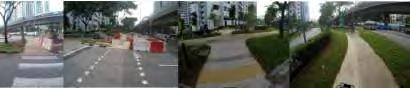
238 239 5 4 3 2 1 DESIGN STRATEGY 2 LEVERAGE URBAN OPEN SPACE visibility analysis
Greenery Continuity assessment
PROJECT I - INTERTOWN SPINE IN COMMONWEALTH AVENUE


feasible spaCe on road


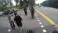


200m
Street tree with big canopy

Feasible space on median space


Feasible space on green strip
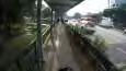


Feasible space on open space
feasible spaCe of Green strip and open spaCe

240 241
site boundary and surroundinG land use barrier analysis speed report BACKGROUND
200m 200m


200m MASTER PLAN BEFORE BEFORE AFTER AFTER BEFORE AFTER
STRATEGY 2- LEVERAGE ON URBAN OPEN SPACES

the ConneCtion between CyClinG system and neiGhbourhood
reasonable rest area and landinG area
how CyClinG network work well with blue and Green system


Water system
New gateway Landing area Cycling system Cycling system
200m 200m
rainwater Garden
10m
Cross seCtion
new Gateway spine transition area
A FAST AND SEAMLESS JOURNEY
the ConneCtion between CyClinG system and neiGhbourhood speed report


Distance:540m Stopping point : 0-1
Distance:580m Stopping point : 1-6
By-pass
BUS STOPS
Departure: Alexandra Queensway PCN
Destination: One-North
CYCLING EXPRESS-WAY
Save time: 1 min
X-crossing
CYCLING TRACK
Greenery assessment :5
CYCLING EXPRESS-WAY
CYCLING LANE
Double yellow line
BUSSINESS
:4
NATURAL PATH
One-north
Gateway
CYCLING PATH

Enlargered street corner + shorter crossing distance
CYCLING LANE
246 247
MRT BRIDGE
MRT BRIDGE HDB
Newstreetscapedefined
Greenery assessment
Greenery assessment :3
Greenery assessment :4
Shade +Shelter
PROJECT J - CYCLING IN GREEN ALONG DOVER ROAD


248 249 One North - Dover Road Cycling Lane People Flow Vehicular Lane
STRATEGY 1
Harmonious commuting for cyclists, pedestrians, drivers


key spaCe desiGn 1


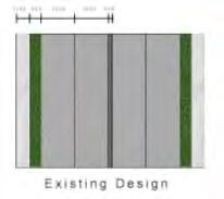
STRATEGY 3

STRATEGY 2
Protected Intersection for cyclists
key spaCe desiGn 2

250 251 new town seConday Campus detailed plan existinG Conditions existinG Conditions 100m 200m
extendinG CyClinG network by linkinG funCtional spaCe
plan
Utilize institutional open areas detailed
SCENIC VIEW ANALYSIS
Experience of cycling in space and greenery
sCeniC view alonG spine b
STREET LEVEL GREENERY AND HEALTH RELATION
Analytical interpretation along all 4 spines
perCeption of CyClinG experienCe via veGetation levellinG


urban GreenspaCes have been determined to provide siGnifiCant health benefits to residents. speCifiC insiGhts on how the desiGn of GreenspaCes, inCludinG street-level Greenery, may independently influenCe walkinG and physiCal aCtivity patterns may help us Gain deeper insiGht reGardinG whiCh type of Greenery has a health impaCt, what kinds of physiCal aCtivity Can be promoted, and what kinds of health benefits Can be delivered ( m lee et al., 2012; sallis et al., 2012).
the Greenway
aye (toll road)
sCeniC view analysis


low-level vision Greenery
nature Can provide stress relief, inCrease soCial interaCtion, enCouraGe physiCal exerCise and even help soothe mental illness.
ayer rajah Cresent
very dense dense less dense
seCtion view of Greenery
mid-level vision Greenery
above vision Greenery
sim lim barraCk rise
sparCe
Greenery simulation to bodily funCtion

252 253
time news what Greens Can do to your mood
http://time.Com/4881665/Green-spaCes-nature-happiness/
LANDSCAPE PERFORMANCE
Investigations on spatial qualities
streetsCape of dover road
institutional
nteGratinG available open spaCe for CyClinG routes
approximately 10% open spaCes for CarparkinG able to add in biCyCle infrastruCture to inCrease ConvenienCes and ConsistenCy

publiC health inCludinG health eatinG habit into lonG distanCe CyClinG routes promote hiGher usaGe of Commuter and utiliZe existinG eateries to be part of healthy CyClinG habits.
1 eatery in every 5 bloCks serve up to 10% of the Community of one area
Greenery CommerCial
Green wall oCCupies 10% of spine b alonG dover Cresent.
street Greenery to enhanCes by 30% to promote lonG distanCe CyClinG and sCeniC view experienCe.

additional ChoiCe for private seCtors staffs to adopt healthy livinG by CyClinG in newly desiGned lanes.
nCreased work and health performanCes & overall health by 50% in physiCal build & better mental health well-beinG
254 255
dover Court international sChool dover neiGhbourhood fairfield methodist sChool buona vista road
PROJECT K - CYCLING LOOP IN ONE NORTH
Vehicle flow
Proposed bicycle flow


People flow
ISSUE STATEMENT AND DESIGN STRATEGY

256 257
LEGEND
Nepal Park
One north park
Wessex
One north MRT
no extra space on vehicle lane
2.9m big mature trees
10m 1.72.9 2.9 6
flow map
width:
alternative way
slope area on the side of the street
ISSUE STATEMENT AND DESIGN STRATEGY
plaza area is not full utilized by people


not full utilized green space in factory area

narrow
The space above the drainage was used for bicycle road, and the surface was used to provide ecology value


Existing picture

258 259
15m 1.5 3 3.7 3.3 2.5 3.6 3.7 7
waiting space for pedestrian zebra line crossing
Detail plan People flow analysis
short cut bicycle track from one north MRT
people crossing the street although there is pedestrian bridge
space along the drainage
3m 1.4m 4.1m 3m 1.4m 2.4m 4.5m 1.7m
Strategy 1
The factory boundary is pushed for bicycle road
Strategy 2
Route A to B, from one north MRT to Biopolis


Total distance-1.2km


Crossing at intersection-1 time , waiting time-1 min
Other road crossing-4 times, no waiting time, may slow down
Pedestrian crossing-2 times,have alternative by pass bicycle road, no waiting time car porch-1 time, no waiting time, may slow down Travelling time with speed of 20km/h -3.6min
Additional time for waiting and slow down -2min
Total time 5.6 min
LANDSCAPE PERFORMANCE
plaza portsdown road
Total lenth of bicycle lane on Portsdown road: 302m shaded area on road: 90%
260 261 0 30 60 120 m
MASTERPLAN
PROJECT L - CYCLING NETWORK FOR NEW DEVELOPMENT

Issues and Characters of Future Development
Issues and Characters of Future Development
Proposed Green Spine
Surface Water flow Future Development Plan


Due to the influence of topography, the surface runoff mainly goes South-wards of the new development, with main open drainage being constructed. Landscape typologies could be leverage on current rainwater flow conditions for the integration of rain gardens.
The major future development is Commercial (30 hectare, almost 4 times the area of Biopolis), Business (12 hectare) and Residential 4.9 hectare for parkland

Elevation Challenges for Accessibility

Existing Vehicle Flow
One-North Avenue is identified to be the key internal spine for vehicle transportation, with the flyover built on Portsdown Ave.


Accessibility of Bus & Pedeatrian Flow

Limited accessibility of buses to new development areas, which mainly access from west boundary main roads


262 263
One North A B Section A - AYE Section B - Portsdown Avenue Rail Corridor Proposed Development (URA) 500m 500m 500m
Portsdown Avenue Dover Road One-North Avenue MRT MRT Planned Linear Park Planned Linear Park Planned Community Space under Viaduct Roof Garden Rail Corridor bound with residential land use Rail Corridor bound with commercial and business land use Rail Corridor bound with residentila land use Community Garden 500m 500m
STRATEGY I: CONTINUITY - Resolve the accessibility barrier caused by topography by forging new connections through different elevations
Forge
STRATEGY II: CONTINUITY - Redesign Vechicle and People Flow to Minimize disturbance


Improved Vehicle Flow
To direct the major flow away from One-North Avenue, and reduce future congestions
Proposed Pedestrian Flow


For enabling the pedestrians to quickly and directly access their destinations in buildings, while minimizing the number of conflicts
STRATEGY III: Strategize Green Spines and Open Spaces for Future Development with integration of Cycling lane and Network


264 265
2nd level Roof Garden 2nd level connection Ground level connection Utilizing existing infrastructure to create transition Elevation transition Bring down to ground level
LANDSCAPE TYPOLOGIES
3 Major Elevation Conditions
Connection between same elevation Rail Corridor Public Plaza Urban Park
Avenue
One-North
500m 50m 200m
Flyover
CYCLING LANE TYPOLOGIES


One-way Cycling Lane along Roads
Elevation Transition

2nd-Level Cycling Track

266 267
DETAIL FLOW Location A
DETAIL FLOW Location B
Flyover Tree Corridor
MASTER PLAN A B C D E F
Open Space
Two-way Cycling Tracks integrated with open spaces and footpaths
Programme: 23 - Rain Garden at Gateway from Portsdown Avenue
200m 100m 100m 100m
Programme: 22 - Entrancing Turf at Gateway from AYE
DETAIL FLOW Location C
Two elevations of Cycling Tracks / Lanes


DETAIL FLOW Location E

DETAIL FLOW

268 269 Programme: 1 - Roof Garden 2 - Activity Lawn 3 - Cycling and Walking Bridge 4 - Fitness / Cycling Facilities 5 - Native Forest with Rain Garden
Location F
DETAIL FLOW Location D 100m 100m 100m 100m Programme: 21 - Activity Lawn & Outdoor Eatery Programme: 15 - Cycling and Walking Bridge 16 - Roof Garden 17 - Urban Park 18 - Eatery 19 - Fitness and Activity Center Programme: 7 - Native Forest 8 - Community Lawn 9 - Community Garden 10 - Farming 11 - Forest Walk 12 - Eatery 13 - Stop-over Amenities with Rain Garden Location of Stop-over and Rain Garden Cycling track going trhough Activity Lawn & Outdoor Eatery
Cycling and Walking Bridge Roof Garden Fitness Roof Garden 2nd Level Connection 2nd Level Connection Ground Level Connection Ground Level Connection
CYCLING ROUTES


Route | Destination 1 to 2
from Portsdown Avenue to Rail Corridor
- Going through Location A, C, E
- Total distance 1.75km
Crossing at intersection - 2 times (+2min)
Other road crossing - 2 times (not main road, internal circulation) - no waiting, may slow down (+1min)
Pedestrian crossing - 2 - no waiting, may slow down
Car porch - 0 - no slow down
Travelling time with speed of 20km/h - 5.25min, counting in 3min additional of waiting / slowing down
- Total time 8.25min
Route | Destination 3 to 4
from Rail Corridor to AYE


- Going through Location F, B
- Total distance 1.39km
Crossing at intersection - 1 time (+1min)
Other road crossing - 3 times (+1min)
Car porch - 1 - may slow down (+0.5min)
Travelling time with speed of 20km/h - 4.14 min, with 2.5min additional - Total time 6.64min

270 271
A B C F D
Road Crossing
E LOCATION F TO DESTINATION 3 LOCATION B FROM DESTINATION 4 LOCATION E TO DESTINATION 2 Destination 1 Destination 4 Destination 3 Destination 2 Flyover cycling track Cyclist and pedestrians prioritized crossing FROM DESTINATION 1 LOCATION A FROM DESTINATION 2 LOCATION C Roof Garden 20,000m2 Urban Plaza 7,000m2 LOCATION A Flyover cycling track Rain Garden 3,000m2 100m Bio-swale Bus-stop Gateway from AYE to One North
Intersection
Barriers:
Cycling entrance to One North Elevated cycling track
different level of Corridor view Elevated Cycling and Walking Bridge Roof Garden Fitness
Native Forest Trail 680m2, with dense and continuous canopy
with
A. Buona Vista MRT Junction_Wang Hanfeng B. Siemens Medical Factory_Xu Yuexin
E. Ghim Moh Cycling Estate_Kuan Wai Tuck Victor F. Cycling Town in Ghim Moh_Liu Xiaolei
I. Spine in Commonwealth Avenue_Wang Zhe J. Cycling in Dover Road_Lam Si Yun Swan
C. JTC Launchpad_Yong Keng-Whye, Raymond D. Commonwealth MRT_Kong Lingchang
G. Cycling Through Indoor and Outdoor_Xu Linxin H. Intra-Connecting Belts_Yao Haomu
K. Cycling Loop_Gao Chenchen L. Cycling Network for New Development_Fan Lei


272 273 B C D A E F G H I J K L


276 277
REFLECTIONS
This MLA studio gave me a different experience compared with the previous two studios. This studio was not only about landscape but also urban design. The design scale was emphasised during the thinking process. When doing the preliminary analysis, we started from large scale to small scale to understand the site context and specific user demands. By contrast, we did the design started from the point major destination to the network future cycling system. This whole process strengthened the logic of my thinking and helped me find the question with targeted solutions. In addition, I learned how to design with the human flow by simulating the process as the core of this studio was user experience. Finally, the group work improved my communication and cooperation skills while my presentation skill still needs to be enhanced in the future study.
Wang Hanfeng


I am very honoured to be involved in this MLA studio ‘Cycling in the Singapore’ and this study has given me a lot of gains. First of all, unlike the traditional landscape design studio, this design combines landscape design with cycling to explore the multi-scale and multifunctionality of landscape design. Secondly, developed our ability to learn and analyse independently. To understand the cycling system as much as possible, we read a lot of theory, cases and practice many new analysis tools such as thermal comfort tools, PTV Vissim in the preliminary analysis. The third is the way to think of different scales. Different from the previous large-scale planning, this time I chose a building as my mobility hub and do the intensify landscape planning at the limited factory space. All the experiences have given me a lot of inspiration.
Xu Yuexin

Everyday Cycling in Singapore studio was a challenging one. There were conflicting mobility infrastructures that one should be aware of, not only by cyclists but also pedestrians, motor vehicles and various types of mobility such as skateboards, scooters, PMDs, electric bikes into consideration. The studio allows me to work in a group where we shared constructive feedbacks and ideas. In a team, it requires good team management where every one of us has to be responsible of our tasks and fulfil them with quality in the limited time frameThis apply on how we would work and perform in the landscape architecture industry once we have graduated. It’s a valuable asset and trait which one should adopt and bring it to the landscape industry which is extremely important and beneficial.
Raymond Yong
This studio is my first attempt to engage with urban design with the landscape perspective, the focal point is workers’ daily lives, and design target is to promote cycling as Singapore’s subsidy transportation method. Although there are some limitations due to the lack of design restriction knowledge in complex urban components, this studio is still the best opportunity for students to explore the working scope as a landscape architect and integrated design could be a more creative concept as future design mainstream. Hopefully, there could be more opportunities for students to get in touch with different disciplinaries to have more brilliant ideas.
Kong Lingchang
278 279
This studio allowed us to explore and design the fundamentals of circulation and mobility. Previously, as a Singaporean, we may complain about the inaccessibility of our neighbourhood with a layman’s attitude, however, after this design adventure, I start to realise the difficulties decision-makers faced when attempting to improve the livelihood of the citizens, even with minor amendments. Though it may seem to be an easy topic, with the complexity of existing planning and policy in Singapore, it was a challenge to achieve the studio’s projected aim. As the first group-oriented studio project, this experience allows individuals to venture according to their strengths and lay a platform for a more effective peer-learning. The flexibility in analysing amenities, transport systems and circulation flow grant us the opportunities to use an array of software from ArcGIS to Vissim. Overall, it was an eye-opening journey that, made me see streetscapes, town infrastructures and movement from a different perspective.
In Singapore, landscape architects are always fighting with space and try to make it multi-functional. In this cycling studio, we compete with both space and existing complex infrastructure. This time, my design project aims to insert a continuous cycling system and keep it harmonious with the vehicle-oriented transportation system on a big scale. It’s not only required to consider designing for one layer but also taking the whole system and multi-layers into account. Especially when designing for urbanised cities, landscape architecture has to work with various systems.
Meanwhile, I realised there is no explicit and exclusive limitation for this profession. Learning how to cooperate with the other disciplines and employ their knowledge to work for landscape architecture project is helpful for the professional work. At last, thanks for my team members, I’ve gained a lot from the group work. This semester is challenging but meaningful, and I hope I could keep the perseverance but work smarter in the future.
Wang Zhe


This studio expands landscape boundary by integrating with architectural and urban planning approach which require us to learn more knowledge beyond landscape and give us a comprehensive understanding of how landscape-centric design can influence the whole urban environment. This experience is also quite challenging for us to explore unfamiliar design approaches. The design topic focuses on current essential issues in Singapore context: cycling is becoming more popular as a healthy and sustainable, but a considerable number of town are not integrated with cycling when planning. Learning to use landscape to promote transport network enrich my knowledge and inspiration. Last, working as a team allow us to help and learn from each other which is critical for our future professional works.
Liu Xiaolei

From this studio, I learned a lot of knowledge about the relationship between people and the built-up environment, mainly in the following aspects: the morphology of the city, human flow, open space utilisation and heat mitigation. Literature review in different aspects of policies, research methods and case studies, teaches me how to quantify and define the core issues according to the analysis from macro scale to micro scale. For example, based on the analysis of human density, traffic congestions, physical barriers, and the accessibility to public transport and amenities, we quantified the so-called mobility gaps and found the areas with the most issues for site selection. In addition, activating and fully utilising the available open spaces (outdoor and indoor) to create a smooth multi-layer flow with integrated heat mitigation strategies is another critical design method that the studio taught me.
Xu Lin Xin


The most important thing I learned from this studio is that being specific and in depth is also essential for a comprehensive solution. As a pre-cyclist for commuting, I have the experience that how would climate, urban planning and social context encourage or discourage people from cycling. Hence, the solution for promoting cycling should be comprehensive, which posed more challenges for this studio since that we need to start from arguing for the necessity of cycling to come up with a detailed operational solution within 12 weeks. Anyway, it’s a tough but good fight.
This semester’s experience was to me a definite ‘culture shock’. It has broadened my horizon by letting me peek into the world of landscape. It is mind-blowing to me regarding how much intricate details and data go into the whole planning process. Previously I thought that landscape was all about design and that having the artistic sense would be fundamental to its success. Having gone through one semester, however, I realised that the logical and practical aspects of it matter so much more. Its multi-faceted thinking required for thorough planning stretched me beyond what I would have imagined. I have come to appreciate and respect the fact that humans do not lord over nature. Furthermore, the wildlife is very much an essential part of the ecosystem, and hence we should take special care to share the same space in harmony, and this is precisely where landscape design can play such a vital role in finding that delicate balance in dividing the area between wildlife and human.an.
The studio of this semester focused on everyday cycling in Singapore, and we tried to find out the possibilities of designing bicycle lane in one north area. We started with the field trip in one north, and we rode bikes on the road to feel the real challenge for cyclists today in Singapore. We learned that design is not only from the perspective of designers but also from the users’ need. This studio is divided into three groups which allow us to approach the design from a different perspective and in this process we can learn from each other beyond our views. Hope that one day what we learn from this studio will apply to the real bicycle road construction in Singapore.
This studio drew my attention and interest to this special group of people who cycle to work in Singapore who are the definite minority for the moment. However, understanding the passion and benefits they obtained through commuting by cycling offers important potentials for strategising livability in Singapore’s urbanised environment and transforming lifestyles of its citizens. Designing with the existing transportation system and road infrastructures to integrate cycling lanes requires not only accessibility and continuity, but some of the key learnings also include the effectiveness in utilising the spaces and landscape architecture approaches in elaborating the experience, especially in preconceptualizing green spines for future development. Thanks to all the guidance, supports and helps throughout the semester, and thank my team for their commitments and hard work even during challenging moments. The teamwork indeed helped me improve my capacity to convey ideas and to collaborate in different stages of design.
280 281
Yao Haomu
Gao Chenchen
Swan Lam
Victor Kuan
Fan Lei Helen
As a studio product which is not censored. It may contain mistakes or deficiencies, and proposed ideas may not represent the position of NUS.
Published by
Department of Architecture
School of Design and Environment
National University of Singapore
4 Architecture Drive Singapore 117566
Tel: +65 65163452
Fax: +65 67793078
Copyright @ 2019 Hwang Yun Hye (ed.)
ISBN: 978-981-14-0187-9
Student Editors
Xu Yuexin
Kuan Wai Tuck Victor
Wang Zhe
Kong Lingchang
Yao Haomu
Copyright @ 2019 Hwang Yun Hye (ed.)
ISBN: 9978-981-14-0187-9
282 283

