Sierra Leone: Guinea 110-1 117-1
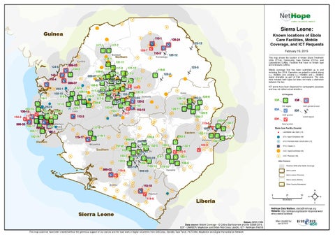
Known locations of Ebola Care Facilities, Mobile Coverage, and ICT Requests
108-24 125-13
117-7 109-7 134-1
Kambia
124-6
134-4
Northern
Koinadugu
111-1
125-12
This map shows the location of known Ebola Treatment Units (ETUs), Community Care Centres (CCCs), and Laboratories (LABs). Facilities that have no known type are Unknowns (UNKs).
131-11
999-03 134-2
131-13 117-2 117-5 109-6 131-12 117-3 142-1 000-07131-8 131-7 103-3 116-4 000-04 000-03 999-07 121-1 108-8 116-7 117-8 109-5 102-4 132-2 093-1 093-2 117-4 000-06 111-12 109-10 131-9 108-10 153-3 153-4 134-3 116-2 111-2 000-05 Tonkolili 116-1 117-6 124-5 120-2 153-2 109-8 111-5 116-5 131-10 093-6 102-8 126-7 Port 119-19 153-1 Loko 102-2 109-11 119-2 102-13 108-12 110-3
102-15 108-13
February 19, 2015
116-3
Bombali
125-5
116-6
Mobile coverage that has been submitted up to and including Nov 2014. Operators are asked to submit strong (>= -92dBm) and variable (>= 100dBm and < -92dBm) signal strengths as part of their submissions. The data here includes both types but does not make a distinction between the two.
125-2
ICT points have been dispersed for cartographic purposes and may not reflect actual locations.
Kono
126-10
ICT Requests
093-3 126-8
119-3
P2P eligible
126-11
ID# 126-9 093-7
120-1 999-04 103-1 102-14 Western
111-4 119-17
ID# 130-7
Boost granted
Ebola Care Facility (Counts)
108-11
141-1
119-1 999-01 Moyamba
157-01 102-3
Southern
103-2
102-11 Kailahun
000-08 159-1
000-11 Bo 000-12 000-09 119-7
132-1
111-3 102-10
109-9
$
Lab/Mobile Lab: Open (12)
! H ! B
ETU: Open/Completed (39)
! H
102-5 160-1
ETU: Planned/Under Construction (12) ETU: Closed (1) CCC: Open/Confirmed (33) CCC: Planned (130)
Other Features
108-6
158-1 000-10
119-4
109-4 102-9 132-3
119-5 999-02
Eastern 093-5
ID# Unmet request
119-8
Western 102-1 Area Rural
VSAT granted & boost
VSAT granted
093-9 999-08
ID#
ID#
102-12 999-05
Potential GSM (2G) Mobile Coverage
119-10 Kenema
Sierra Leone Sierra Leone (Province) Sierra Leone (District)
Bonthe
Other Country Boundaries
119-18 Pujehun
119-6
0
Liberia
25 Kilometers
50
²
NetHope Data Mailbox: ebola@nethope.org Website: http://nethope.org/disaster-response/westafrica-ebola-outbreak
Sierra Leone Datum::WGS 1984 Data source: Mobile Coverage - Š Collins Bartholomew and the GSMA 2014, ECF - UNMEER, MapAction and British Red Cross (Jan24), ICT - NetHope (Feb19) This map could not have been created without the generous support of our donors and the hard work of digital volunteers from GISCorps, Standby Task Force, HOTOSM, MapAction and Digital Humanitarian Network
Map created by: cak 021915