Senegal Guinea Bissau
Mali
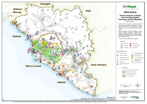
West Africa: Known locations of Ebola Care Facilities, Mobile Coverage, and ICT Requests April 21, 2015 This map shows the location of known Ebola Treatment Units/Ebola Health Centers (ETUs/EHCs), Community Care Centres (CCCs), and Laboratories (LABs). Facilities that have no known type are Unknowns (UNKs). Mobile coverage that has been submitted up to and including Nov 2014. Operators are asked to submit strong (>= -92dBm) and variable (>= 100dBm and < 92dBm) signal strengths as part of their submissions. The data here includes both types but does not make a distinction between the two.
Guinea
ICT points have been dispersed for cartographic ICT Requests P2P granted
Boost granted
P2P eligible
VSAT granted & boost
VSAT granted
Unmet request
Ebola Care Facilities - Type: !
! !
Unknown: Unknown (0)
$
Lab/Mobile Lab: Open (23)
+ $ + ! $
Ò
Cote d'Ivoire
Sierra Leone
H ! B
Unknown: Open (1)
! H Ç P
Lab/Mobile Lab: Planned (1) LAB, Closed (3)
ETU/EHC: Planned/Under Construction (12) ETU/EHC: Closed (9) CCC: Open/Confirmed (38) CCC: Planned/Under Construction (50) CCC: Unknown (49)
ETU/EHC: Open/Completed (98)
Other Features Potential GSM (2G) Mobile Coverage West Africa Country Boundaries West Africa Admin 1 Boundaries Other Country Boundaries
Liberia 0
25
50
Kilometers
100
²
NetHope Data Mailbox: ebola@nethope.org Website: http://nethope.org/disaster-response/westafrica-ebola-outbreak
Datum::WGS 1984 Data source: Mobile Coverage - © Collins Bartholomew and the GSMA 2014, ECF - UNMEER, MapAction, British Red Cross, UNICEF, OCHA Mali (Mar27), ICT - NetHope (Apr19) This map could not have been created without the generous support of our donors and the hard work of digital volunteers from GISCorps, Standby Task Force, HOTOSM, MapAction and Digital Humanitarian Network
Map created by: cak 042115