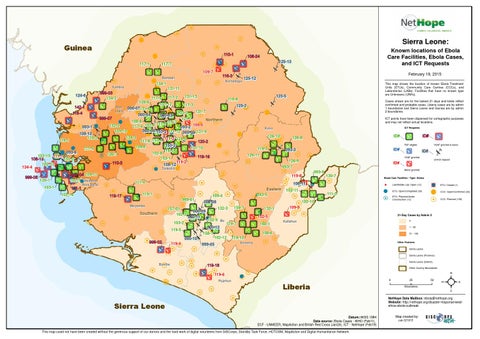
Sierra Leone:
Guinea 110-1 117-1
Known locations of Ebola Care Facilities, Ebola Cases, and ICT Requests
108-24 125-13
117-7 109-7 Koinadugu
134-1 Kambia
124-6
131-13 117-2 117-5 109-6 131-12 117-3 142-1 Port 000-07131-8 Loko 131-7 103-3 116-4 000-04 000-03 999-07 121-1 Northern 108-8 116-7 117-8 109-5 102-4 132-2 117-4 093-1 093-2 000-06 153-3 111-12 000-05 131-9 109-10 108-10 134-3 116-2 111-2 124-5 116-1 117-6 153-4 120-2 153-2 109-8 131-10 111-5 116-5 093-6 102-8 126-7 102-15 111-1 119-19 153-1 108-13 102-2 119-2 110-3 102-13 108-12 134-4 Tonkolili 999-08
120-1 103-1
125-12
125-5
116-6
Cases shown are for the lastest 21 days and totals reflect confirmed and probable cases. Liberia cases are by admin 1 boundaries and Sierra Leone and Guinea are by admin 2 boundaries.
125-2
ICT points have been dispersed for cartographic purposes and may not reflect actual locations. ICT Requests
Kono
126-10
ID#
093-3
126-11
Unmet request
Boost granted
130-7
108-11
119-1 999-01 Moyamba
157-01 102-3
Southern
119-5 999-02
000-10 119-4
102-11
111-3 102-10
000-08
000-09 000-11
103-2
Eastern 093-5
109-4 132-3
159-1
132-1
Ebola Care Facilities - Type: Status
$
Lab/Mobile Lab: Open (12)
! H
ETU: Open/Completed (39) ETU: Planned/Under Construction (12)
Bo
119-7
000-12 158-1 102-12
160-1
ETU: Closed (1) CCC: Open/Confirmed (33) CCC: Planned (130)
21-Day Cases by Admin 2 0
Kailahun
1 - 50
108-6
51 - 100
119-10 Other Features
Kenema
999-05
! B ! H
109-9
102-5
102-9
ID#
ID# 093-9
111-4 119-17
VSAT granted & boost
VSAT granted
126-9 093-7 119-8
Area Rural
ID#
ID#
126-8
P2P eligible
119-3
141-1 102-14
This map shows the location of known Ebola Treatment Units (ETUs), Community Care Centres (CCCs), and Laboratories (LABs). Facilities that have no known type are Unknowns (UNKs).
131-11
999-03 134-2
999-04 109-11 102-1 Western
February 19, 2015
116-3
Bombali
Sierra Leone Sierra Leone (Province) Sierra Leone (District)
Bonthe
119-18
Other Country Boundaries
119-6 0
Pujehun
Liberia
25 Kilometers
50
²
NetHope Data Mailbox: ebola@nethope.org Website: http://nethope.org/disaster-response/westafrica-ebola-outbreak
Sierra Leone Datum::WGS 1984 Data source: Ebola Cases - WHO (Feb11), ECF - UNMEER, MapAction and British Red Cross (Jan24), ICT - NetHope (Feb19) This map could not have been created without the generous support of our donors and the hard work of digital volunteers from GISCorps, Standby Task Force, HOTOSM, MapAction and Digital Humanitarian Network
Map created by: cak 021915