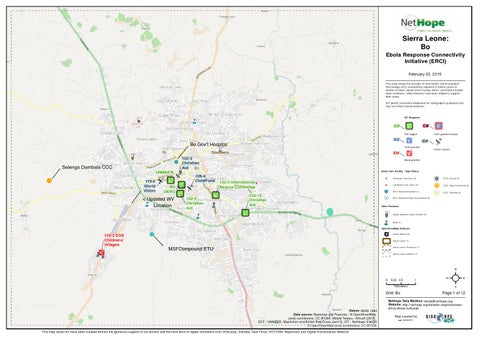
Sierra Leone: Bo Ebola Response Connectivity Initiative (ERCI) February 03, 2015 This map shows the location of Information Communication Technology (ICT) connectivity requests in S ierra Leone in relation to NGO, Ebola Care Facility (ECF), and A fricell mobile tower locations. Other features have been added to support field crews. ICT points have been dispersed for cartographic purposes and may not reflect actual locations.
ICT Requests
ID#
ID# P2P eligible
ID#
Bo Gov't Hospital
VSAT granted & boost
ID# ID# VSAT granted Unmet r eques t
Southern
Bo
ID#
102-3 102-3 Christian Christian Aid Aid
Selenga Dambala CCC UNMEER 119-5 119-5 World World Vision Vision
Bo DERC
< Updated WV Location
Boost granted
Ebola Care Facility - Type:Statu s
109-4 109-4 ChildFund ChildFund 132-3 International Rescue Committee 102-9 Christian Aid
!
Un kno wn: Unk nown (0)
$
Lab/Mob ile Lab: Ope n (2)
! H
102-12 Christian Aid
ETU: Op en/Comp lete d (1)
! B
! H
ETU: Clo sed (0)
CCC: Ope n/Confirmed (0)
CCC: Planned (2)
ETU: Planned /Under Cons truction (0)
Other Features
_
i m n
Mobile Network Tower (A fricell) (5)
NG O (7)
OpenStreetMap Featu res
a
103-2 SOS Childrens' Villages
Police Station (0 ) Sierra Leone (1) Sierra Leone (P rov inc e) (1 )
MSFCompound ETU
Sierra Leone (Distric t) (1)
0
0.25 0.5
1
Kilometers
Grid: Bo
Datum::WGS 1984 Data source: Basemap and Features - © OpenStreetMap (and) contributors, CC-BY-SA, Mobile Towers - Africell (2014), ECF - UNMEER, MapAction and British Red Cross (Jan13), ICT - NetHope (Feb02)
© OpenStreetMap (and) contributors, CC-BY-SA This map could not have been created without the generous support of our donors and the hard work of digital volunteers from GISCorps, Standby Task Force, HOTOSM, MapAction and Digital Hum anitarian Network
²
Page 1 of 12
NetHope Data Mailbox: ebola@nethope.org Website: http://nethope.org/disaster-response/westafrica-ebola-outbreak Map created by: cak 020315