093-8
133-2
114-2 125-9
125-3 108-18
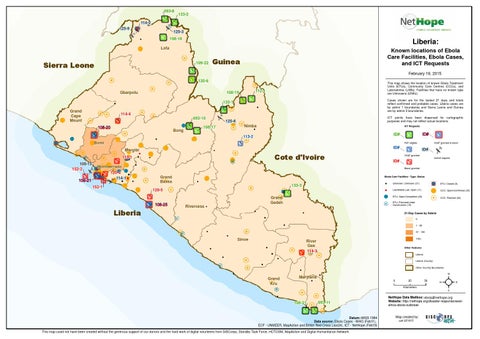
Liberia:
Lofa
109-22
Sierra Leone
Known locations of Ebola Care Facilities, Ebola Cases, and ICT Requests
Guinea
February 19, 2015 120-6 112-1
108-19
Gbarpolu
This map shows the location of known Ebola Treatment Units (ETUs), Community Care Centres (CCCs), and Laboratories (LABs). Facilities that have no known type are Unknowns (UNKs). Cases shown are for the lastest 21 days and totals reflect confirmed and probable cases. Liberia cases are by admin 1 boundaries and Sierra Leone and Guinea are by admin 2 boundaries.
133-1 Grand Cape Mount
114-4 093-10 108-20
Bong
108-17
ICT points have been dispersed for cartographic purposes and may not reflect actual locations.
125-6 Nimba
ICT Requests
Bomi
P2P eligible
ID#
Margibi
Cote d'Ivoire
113-1 108-15 152-2 109-21
ID#
ID#
113-2
Montserrado 120-4 114-1
ID# VSAT granted Unmet request
ID# Boost granted
Grand Bassa
Ebola Care Facilities - Type: Status
133-3
152-1
VSAT granted & boost
120-5
108-25
Grand Gedeh Rivercess
!
Unknown: Unknown (37)
$
Lab/Mobile Lab: Open (11)
! H
ETU: Open/Completed (23)
! B ! H
ETU: Closed (5) CCC: Open/Confirmed (35) CCC: Planned (52)
ETU: Planned/Under Construction (15)
Liberia
21-Day Cases by Admin 0 1 - 50 51 - 100
Sinoe
100+
River Gee 114-3
Other Features Liberia Liberia (County) Other Country Boundaries
Grand Kru
Maryland 0
25 Kilometers
108-21
093-11
Datum::WGS 1984 Data source: Ebola Cases - WHO (Feb11), ECF - UNMEER, MapAction and British Red Cross (Jan24), ICT - NetHope (Feb19) This map could not have been created without the generous support of our donors and the hard work of digital volunteers from GISCorps, Standby Task Force, HOTOSM, MapAction and Digital Humanitarian Network
50
²
NetHope Data Mailbox: ebola@nethope.org Website: http://nethope.org/disaster-response/westafrica-ebola-outbreak
Map created by: cak 021915