125-3
133-2
!
$ ! ! $
108-18
!
!
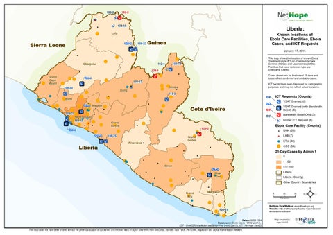
Liberia:
Lofa !
120-6
Sierra Leone
109-22
Known locations of Ebola Care Facilities, Ebola Cases, and ICT Requests
Guinea
! !
Gbarpolu
!
!
!
January 17, 2015
!
!
Grand Cape Mount
!!
!
! !
!
! !!
!! ! !Bomi
!
! ! !
!
! !
108-20
!
133-1 114-4
!
! Margibi ! ! 113-1 !! ! ! ! 109-21! ! !! ! Montserrado ! ! ! ! ! ! ! ! ! 108-15 ! ! ! ! ! ! !!!! ! ! !! ! ! 120-4 !
113-2
!
!
!
!
!
!
!
ICT Requests (Counts)
ID#
VSAT Granted (6)
ID#
! ! !
$
!
ICT points have been dispersed for cartographic purposes and may not reflect actual locations.
!
Bong
!
Cases shown are for the lastest 21 days and totals reflect confirmed and probable cases.
! !Nimba !
$ !! !
!
!
108-17 !
!
108-19
112-1
!
This map shows the location of known Ebola Treatment Units (ETUs), Community Care Centres (CCCs), and Laboratories (LABs). Facilities that have no known type are Unknowns (UNKs).
Cote d'Ivoire
VSAT Granted (with Bandwidth Boost) (6)
ID#
Bandwidth Boost Only (3)
ID#
!
$
!
!
$
$
!
!
120-5
Unmet ICT Request (6)
Grand Bassa
! !
!
!
Ebola Care Facility (Counts)
133-3
!
! ! Grand !
108-25
Gedeh
! !
Rivercess
!
Liberia
!
!
!
!!!
$
LAB (7)
!
ETU (48)
!
CCC (84)
0
!
!
UNK (39)
21-Day Cases by Admin 1
!
!
!
1 - 50
Sinoe
51 - 100
114-3 !
!
Liberia
River ! ! ! !Gee ! !
! !
! !
!
!
Liberia (County) Other Country Boundaries
! !
!
Grand Kru
!
! !
Maryland
!
!
0
25 Kilometers
!
! ! 108-21 ! ! !
Datum::WGS 1984 Data source: Ebola Cases - WHO (Jan14), ECF - UNMEER, MapAction and British Red Cross (Jan13), ICT - NetHope (Jan02) This map could not have been created without the generous support of our donors and the hard work of digital volunteers from GISCorps, Standby Task Force, HOTOSM, MapAction and Digital Humanitarian Network
50
²
NetHope Data Mailbox: ebola@nethope.org Website: http://nethope.org/disaster-response/westafrica-ebola-outbreak
Map created by: mgw 011715