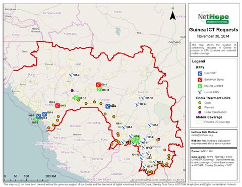
¯ Guinea ICT Requests November 30, 2014
This map shows the location of connectivity requests in Guinea in relation to ETU locations and potential mobile coverage
Legend RFPs
New VSAT
105-4
Bandwidth Boost 109-1
BGANs Granted
109-13
105-3
109-3
Unmet RFPs
109-14 109-2
Ebola Treatment Units
101-10
Open
107-6
108-4
Planned
Under Construction
108-1
Mobile Coverage
108-3
105-2
115-1
107-3
115-3 101-4 107-8
NetHope Data Mailbox: ebola@nethope.org
101-8
Website: http://nethope.org/disasterresponse/west-africa-ebola-outbreak
107-9 101-9 101-13
107-1 107-5
0
50
100
200 KM
Potential 2G coverage
Datum::WGS 1984 129-1
© OpenStreetMap (and) contributors, CC-BY-SA
Data source: RFPs - NetHope, ETUs UNMEER, Basemap - OpenStreetMaps, Mobile coverage - Collins Bartholomew and GSMA, Country Boundary - WFP
This map could not have been created without the generous support of our donors and the hard work of digital volunteers from GISCorps, Standby Task Force, HOTOSM, MapAction and Digital Humanitarian Network