Senegal Guinea: Koundara
Mali
Guinea Bissau
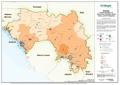
Known locations of Ebola Care Facilities, Ebola Cases, and ICT Requests
Mali
Labe
January 27, 2015
Koubia
Lelouma
Gaoual
Siguiri
Dinguiraye
This map shows the location of known Ebola Treatment Units (ETUs), Community Care Centres (CCCs), and Laboratories (LABs). Facilities that have no known type are Unknowns (UNKs).
Tougue
105-4 Labe 105-4
!
Cases shown are for the lastest 21 days and totals reflect confirmed and probable cases. Liberia cases are by admin 1 boundaries and Sierra Leone and Guinea are by admin 2 boundaries.
Boke Boke
109-1
! Telimele
Dalaba
Kankan
Pita
H
Dabola
Mamou
Kouroussa
Faranah
Fria
ICT Requests
Mamou
H
Kindia
Boffa
109-2 Dubreka
105-3 105-3 Kindia
H
H
H$
108-3 109-3 109-3
$$ !
115-2 115-2
H
ID#
Kankan
ID#
108-5 108-5
VSAT Granted (3)
H H
H Forecariah ! H 107-7 107-7 H H
Unmet ICT Request (27)
Ebola Care Facilities - Type: Status
H Kissidougou 115-1 115-1
107-3 107-3
H Kerouane 101-4 101-4
H 101-8 101-8 101-7 H 101-7 Macenta 108-4 107-8 107-8 HH HH H! 107-9 H 107-9 H 101-10 HH 101-10 H! H 101-9 101-9 H Gueckedou
$
$
Lab/Mobile Lab: Open (6)
! H
ETU: Open/Completed (7) ETU: Planned/Under Construction (7)
H
Beyla
Sierra Leone
P2P Eligible (0)
ID# Bandwith Boost Granted (2)
Faranah
105-1 105-1
ID#
107-6 107-6
H H
108-1 105-2 105-2 Coyah
Guinea
ICT points have been dispersed for cartographic purposes and may not reflect actual locations.
Mandiana
CCC: Planned/Under Construction (40)
21-Day Cases by Admin 2
125-1 125-1
0 1 - 50
$
101-3 101-3
101-6 101-6 101-12 101-12
101-13 101-13
Other Features Guinea
LolaH Nzerekore 107-1 107-1 H ! H H H H 129-1 129-1 H
Guinea (Region) Guinea (Prefecture)
$
H H
HYomou HH
Liberia
H
101-11 101-11 H
H
107-5 107-5
Nzerekore
51 - 100
Other Country Boundaries
0
Cote d'Ivoire
Datum::WGS 1984 Data source: Ebola Cases - WHO (Jan21), ECF - UNMEER, MapAction and British Red Cross (Jan24), ICT - NetHope (Jan25) This map could not have been created without the generous support of our donors and the hard work of digital volunteers from GISCorps, Standby Task Force, HOTOSM, MapAction and Digital Humanitarian Network
25
50 Kilometers
100
²
NetHope Data Mailbox: ebola@nethope.org Website: http://nethope.org/disaster-response/westafrica-ebola-outbreak Map created by: mgw 012715