West Africa RFPs December 01, 2014
105-4
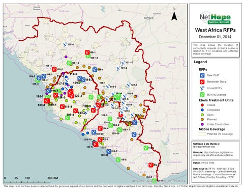
This map shows the location of connectivity requests in Sierra Leone in relation to ETU locations and potential mobile coverage
109-1 109-13 105-3 108-1
109-3 105-2
108-3
109-2
117-7
109-7
117-1 116-4
116-1 103-1
116-3
111-4
115-1
109-4
115-3
107-8
103-2
111-3 104-3 104-1 114-4 108-20
108-15 130-6
Bandwidth Boost
107-3
101-4
109-9
RFPs New VSAT
120-2
111-5 120-1
107-6
108-4
110-1
Legend
101-10
109-14
Unmet RFPs
101-8
BGANs Granted
107-9
101-13
107-1
120-8 104-2 109-25
Ebola Treatment Units
101-9
107-5
Closed
Completed Open
129-1
Planned
112-1
Under Construction
Mobile Coverage
108-17
Potential 2G coverage
113-2
113-1 120-5 108-25
118-1
120-7 118-2
114-3
0
65
130
260 KM
126-5
126-6 Š O penStreetMap (and) contributors, CC-BY-S A
NetHope Data Mailbox: ebola@nethope.org Website: http://nethope.org/disasterresponse/west-africa-ebola-outbreak Datum ::WGS 1984 Data sour ce: RFPs - NetHope, ETUs UNMEER, Basemap - OpenStreetMaps, Mobile coverage - Collins Bartholomew and G SMA , Country Boundary - WFP
This map could not have been created without the generous support of our donors and the hard work of digital volunteers from GISCorps, Standby Task Force, HOTO SM, MapAction and Digital Humanitarian Network