Senegal Guinea Bissau
Mali
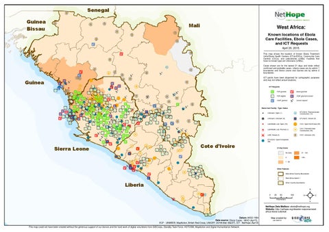
West Africa: Known locations of Ebola Care Facilities, Ebola Cases, and ICT Requests April 20, 2015 This map shows the location of known Ebola Treatment Units/Ebola Health Centers (ETUs/EHCs), Community Care Centres (CCCs), and Laboratories (LABs). Facilities that have no known type are Unknowns (UNKs). Cases shown are for the lastest 21 days and totals reflect confirmed and probable cases. Liberia cases are by admin 1 boundaries and Sierra Leone and Guinea are by admin 2 boundaries. ICT points have been dispersed for cartographic purposes and may not reflect actual locations.
Guinea
ICT Requests P2P granted
Boost granted
P2P eligible
VSAT granted & boost
VSAT granted
Unmet request
Ebola Care Facility - Type: Status !
! !
Unknown: Unknown (0)
$
Lab/Mobile Lab: Open (23)
Ò
$ + $ + !
! H Ç P
Lab/Mobile Lab: Planned (1) LAB, Closed (3)
ETU/EHC: Planned/Under Construction (12) ETU/EHC: Closed (9) CCC: Open/Confirmed (38) CCC: Planned/Under Construction (50) CCC: Unknown (49)
ETU/EHC: Open/Completed (98)
Cote d'Ivoire
Sierra Leone
H ! B
Unknown: Open (1)
21-Day Cases No Data
51 - 100
0
100+
1 - 50
Other Features West Africa Country Boundaries West Africa Admin 1 Other Country Boundaries
Liberia 0
25
50
Kilometers
100
²
NetHope Data Mailbox: ebola@nethope.org Website: http://nethope.org/disaster-response/westafrica-ebola-outbreak Datum::WGS 1984 Data source: Ebola Cases - WHO (Apr15), ECF - UNMEER, MapAction, British Red Cross, UNICEF, OCHA Mali (Mar27), ICT - NetHope (Apr19) This map could not have been created without the generous support of our donors and the hard work of digital volunteers from GISCorps, Standby Task Force, HOTOSM, MapAction and Digital Humanitarian Network
Map created by: cak 042015