18
50
35
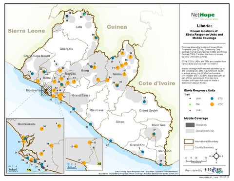
Liberia:
Known locations of Ebola Response Units and Mobile Coverage
56
19
6 23
33
43
5
48
32
31
3
29
53 12 42
16
1
41
7
51
52
20
21
This map shows the location of known Ebola Treatment Units (ETUs), Community Care Centres (CCCs), Laboratories (LABs), and Triage Centres (TRIs). Facilities that have no known type are Unknowns (UNKs).
30 55
ETUs, CCCs, LABs, and TRIs are compiled from various data sources as of 15 Oct 2014. Mobile coverage that has been submitted up to and including Dec 2013. Operators are asked to submit strong (>= -92dBm) and variable (>= 100dBm and < -92dBm) signal strengths as part of their submissions. The data here includes both types but does not make a distinction between the two.
47
54 26
46
9
Ebola Response Units
13
Type
57
UNK
!
ETU
#
TRI
!
CCC
$
LAB
!
37 8
Mobile Coverage Montserrado
4
36
!
!
Global 3G
10
17
Global GSM (2G)
49
!!25 40 !
39
34 $
!! 45 11
-
012
4
Kilometers
!
13
22
International Boundary Country Boundary
2
!
!
3G
!
44
! !!
$$ 14 38 15
-
28
!
!
-
27
!12
37 012
4
Kilometers
!
!
3G
24
Data Sources: Ebola Response Units - MapAction, Operation United Assistance; Boundaries - Humanitarian Response; Mobile Coverage - Š Collins Bartholomew and the GSMA 2014
0
15
30
60
Kilometers
²
Map created by etus_mobile_GC_*.mxd
10.28.14