MUNICIPAL GUIDANCE
Comprehensive Plan | Section 6
As part of the planning process to develop Blueprint Brunswick 2040, six municipalities within the county chose to engaged citizens and other stakeholders to define a future land use vision specifically for their respective jurisdictions. The pages that follow contain the plans developed for each town. The plans summarize relevant background information, present the outcomes of the community engagement activities, and highlight the major issues and opportunities identified. The plans for each also feature a future land use map. Maps are supported by recommendations that relate to the recommended policies forThe County (refer to Section 4).
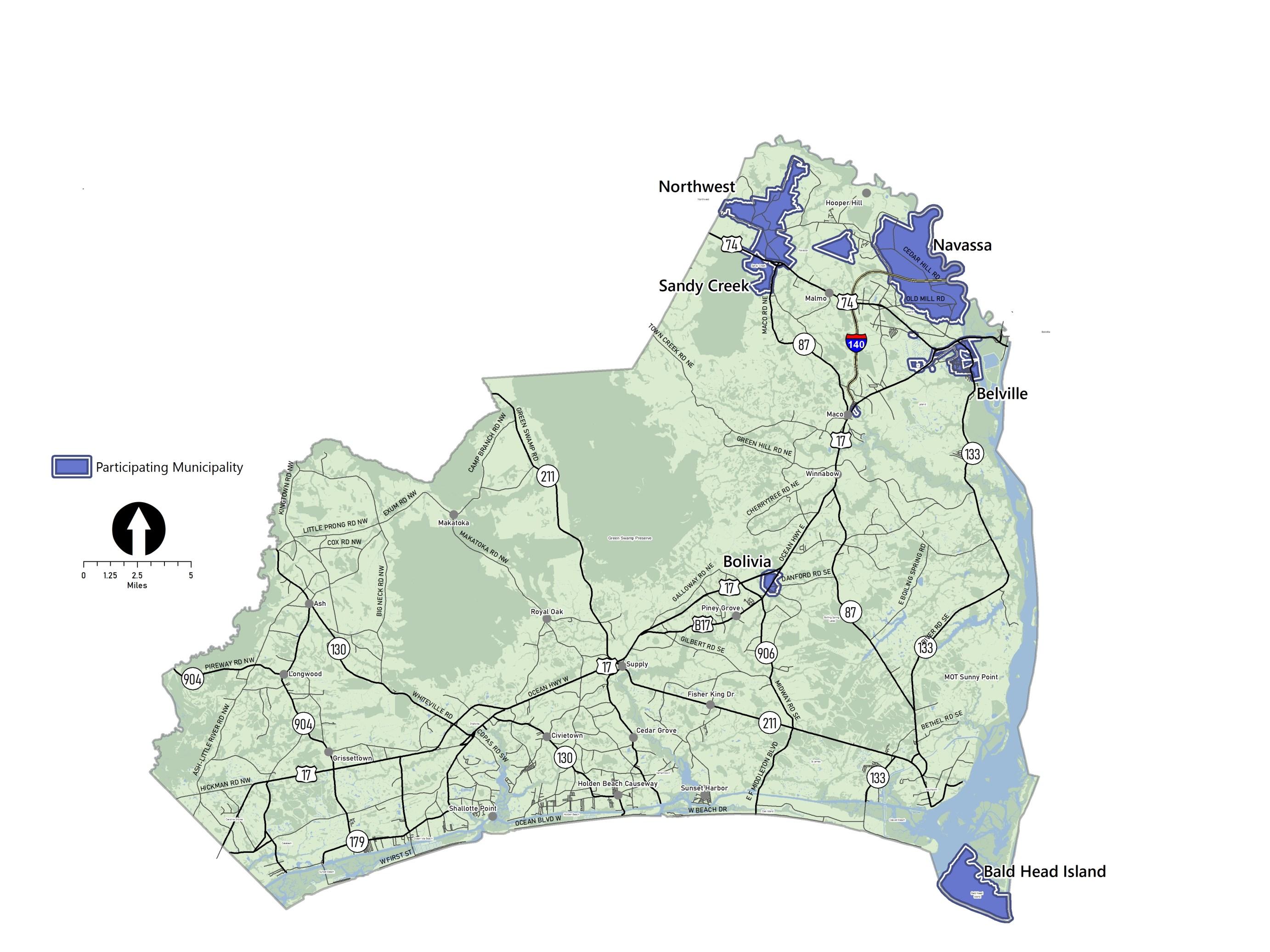
Six municipalities chose to participate in the planning process to create land use plans that supplement the details of this countywide plan. Their jurisdictions are delineated on this map.
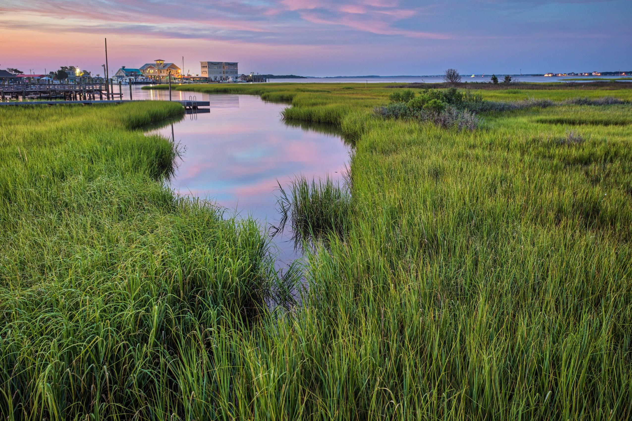
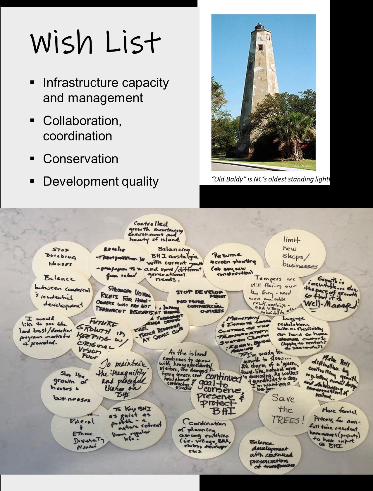
The Village of Bald Head Island is a small community that incorporated in 1985, just two years after development began. Here, planning for the future means striking a balance between conserving the natural and cultural features of the island and providing the infrastructure and services that meet the needs of a community that is still in the process of developing. This plan defines ways the development pattern can shift to accommodate the uses and activities the community desires while preserving the special characteristics of the village and the island it occupies.

Existing Land Use & Development Pattern
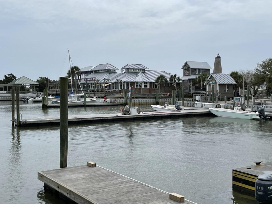
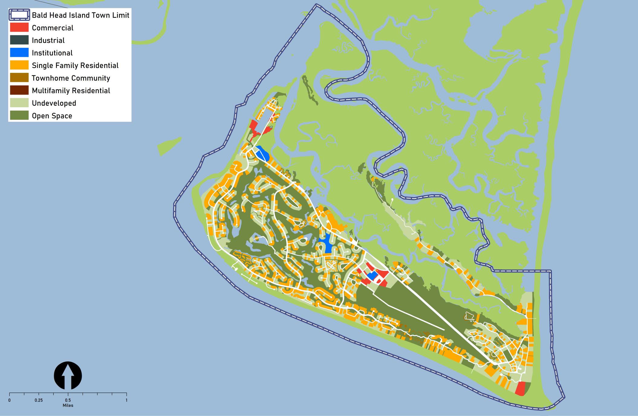
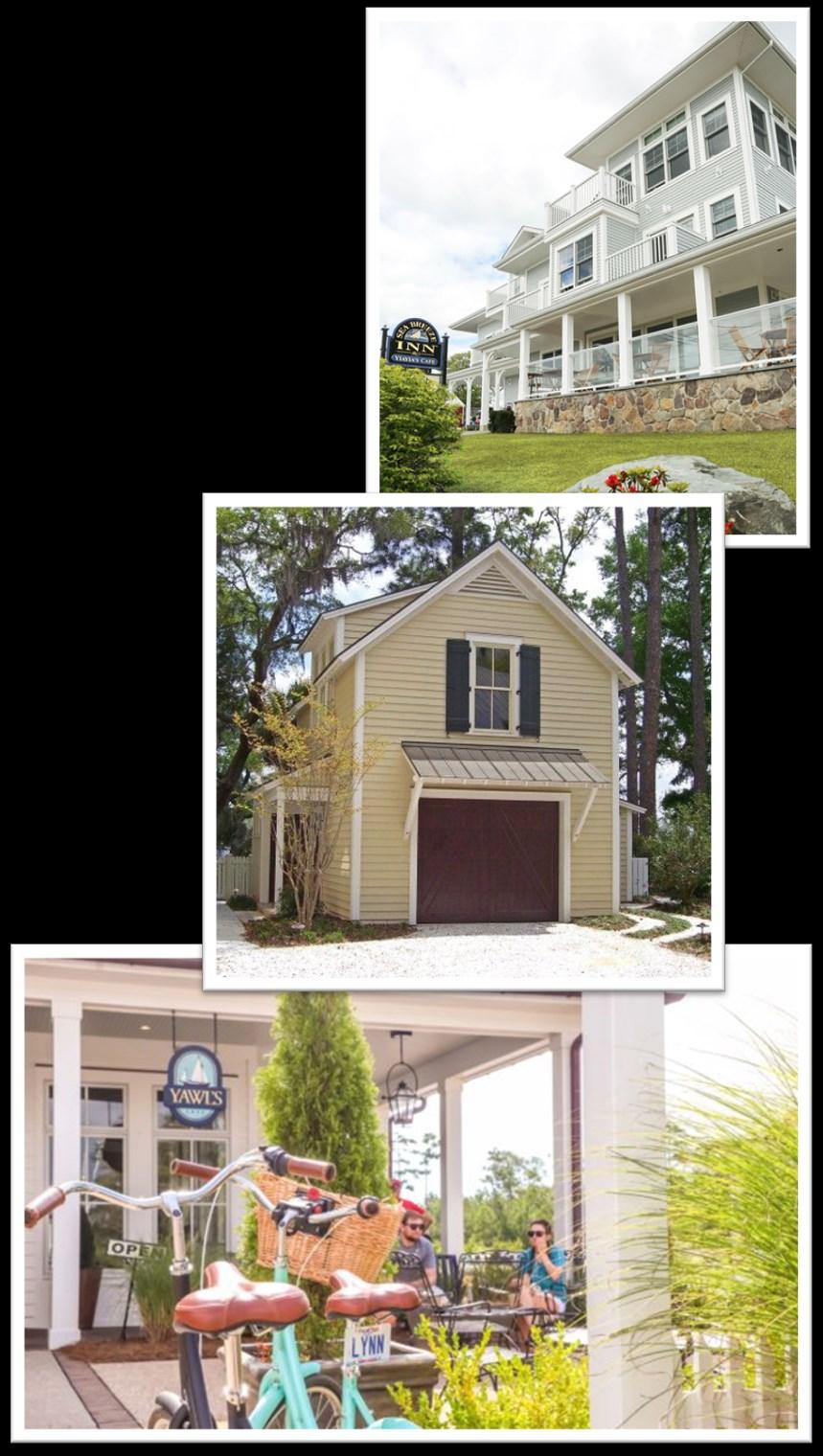
Created originally as a resort community for people to “live in harmony with nature,” the development on the island is comprised primarily of single-family homes around a golf course, a marina and various amenities, and some commercial uses in a few locations. (See Figure 1.) The commercial areas are devoted to restaurants, small shops, convenience grocery, and personal services and serve both the residents of the island as well as the many visitors that travel to the island for day trips or longer stays. The environmental constraints and lack of automobiles have limited the scale of development. The natural and cultural assets are prominent features of the community. “Old Baldy,” for example, is the iconic lighthouse. Constructed in 1817, this historic structure is an important relic of Brunswick County’s seafaring past.
Environment
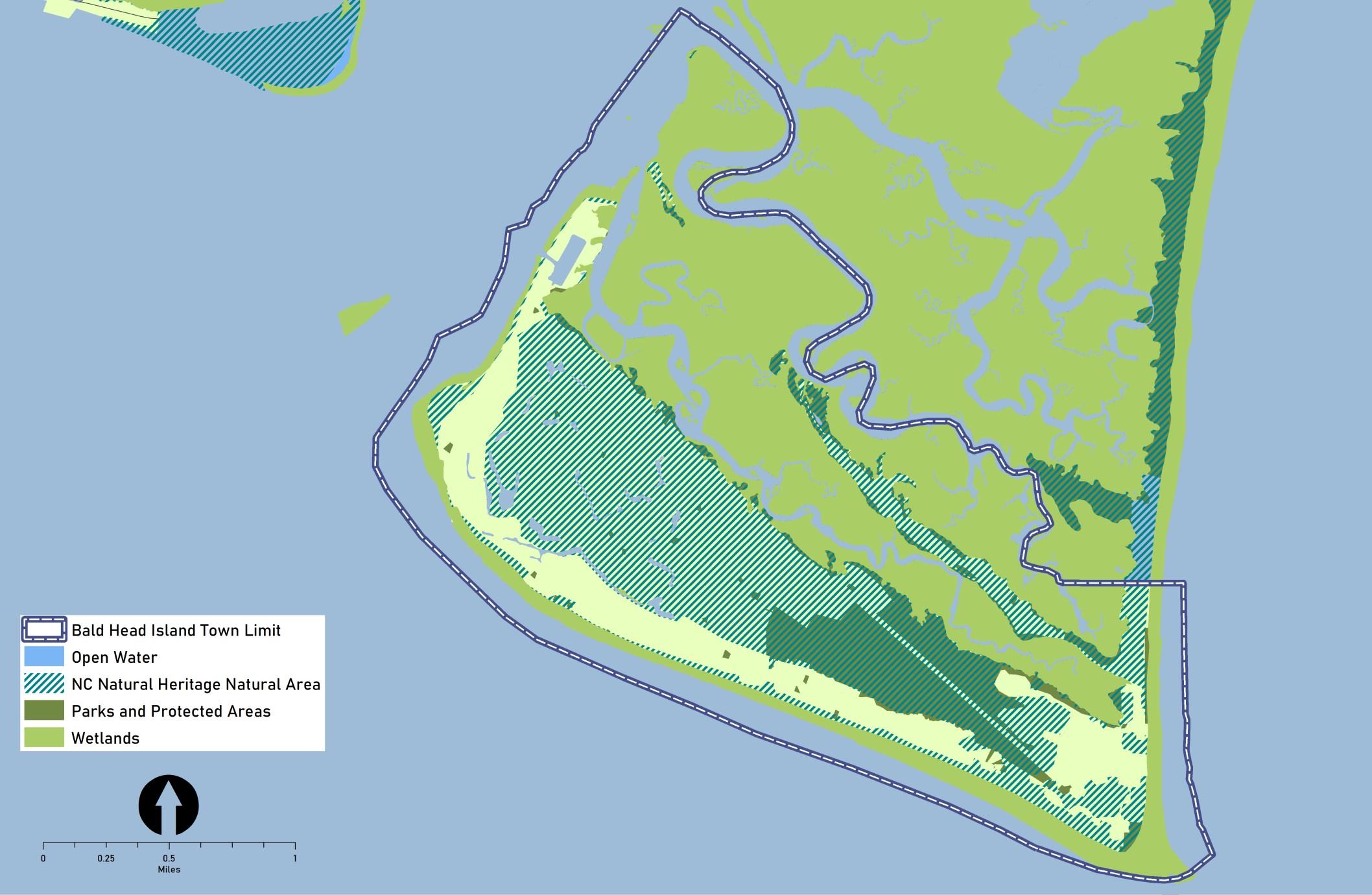
Bald Head Island is the southernmost of North Carolina's cape islands. With most of its 12,000 acres permanently protected as open space, the island boasts ecological diversity with ecosystems comprised of beachfront, dune ridge, maritime forest, and marshland. Through the work of BHI Conservancy, it is nationally recognized for its sea turtle nesting activity. The State of North Carolina manages most of the land as the Bald Head Island State Natural Area. Within the Village, Smith Island Land Trust (SILT) has been instrumental in protecting over 40 properties with conservation easements, bringing the total area of conservation land inside the village to almost 600 acres. The easements encompass some of the areas delineated as “Natural Heritage Natural Areas,” which support rare plant and animal habitats (see Figure 2). Subject to barrier island dynamics, the island has evolved over time, particularly in response to the impacts of tropical storms and hurricanes.
Key Issues & Opportunities
Through the community engagement activities, the residents and other stakeholders shared concerns about future growth, anticipated changes to the development pattern, and potential impacts. While meeting participants and survey respondents identified several issues to be addressed in the coming years, they also highlighted some opportunities to consider as change occurs. The following summary reflects some the concerns and ideas expressed.
Transportation
Residents and visitors rely on electric carts and bicycles to travel around the island. Residents and business owners noted concerns ranging from the long-term viability of ferry service to the island, as automobiles are not permitted, to the challenges of feasibly maintaining the streets (roads and “wynds”), to safety, particularly for pedestrians and cyclists.
Environment
Though much of the land is protected as undisturbed open space, residents are concerned that impacts stemming from new development and increasing tourism could jeopardize the health of the fragile ecosystems.
Housing
Though some desire more housing diversity, residents seemed equally interested in better management of properties used as short-term rentals.
Other Uses
The level of activity on the island is presenting opportunities for a few more commercial services as well as beach-related facilities distributed to improve access.
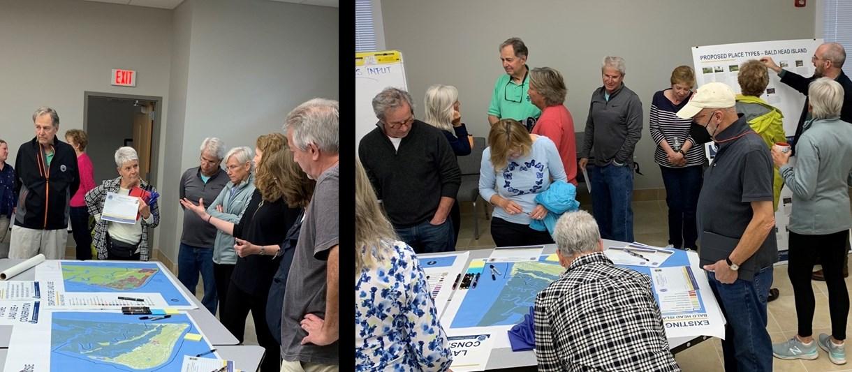
Community Engagement
During the Blueprint Brunswick 2040 planning process, Bald Head Island residents and property owners participated in district level meetings. In addition, community meetings were held at the Village offices on Bald Head Island in March and April of 2022. All such meetings were structured and facilitated to gather input on issues, opportunities and aspirations related to the future development pattern and conservation efforts. Feedback provided through online surveys (22 responses) augmented the input recorded at the in-person meetings.
Top-Ranked Goals
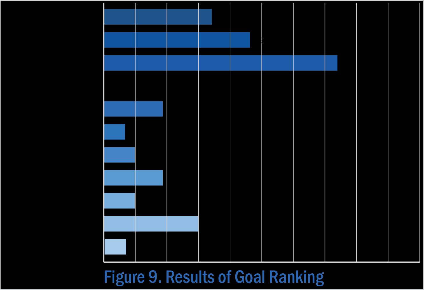
When asked to review the goals for the future of Brunswick County, meeting participants shared their opinions and voted for those they believe are most relevant to Bald Head Island. The goals pertaining to infrastructure, the environment, and land use and growth management ranked first, second, and third, respectively.
Ideas for Land Use + Precedents
• Health services, senior care/support
• School (charter)
• Lodging
• Temporary / pop-up businesses
• ABC Store
• More restaurants, bakery
• Dog grooming, boarding
• Accessory dwelling units (ADUs), garage apartments
• Access points to beaches (with parking and restrooms)
• Playground(s)
• Dog park
• Agriculture
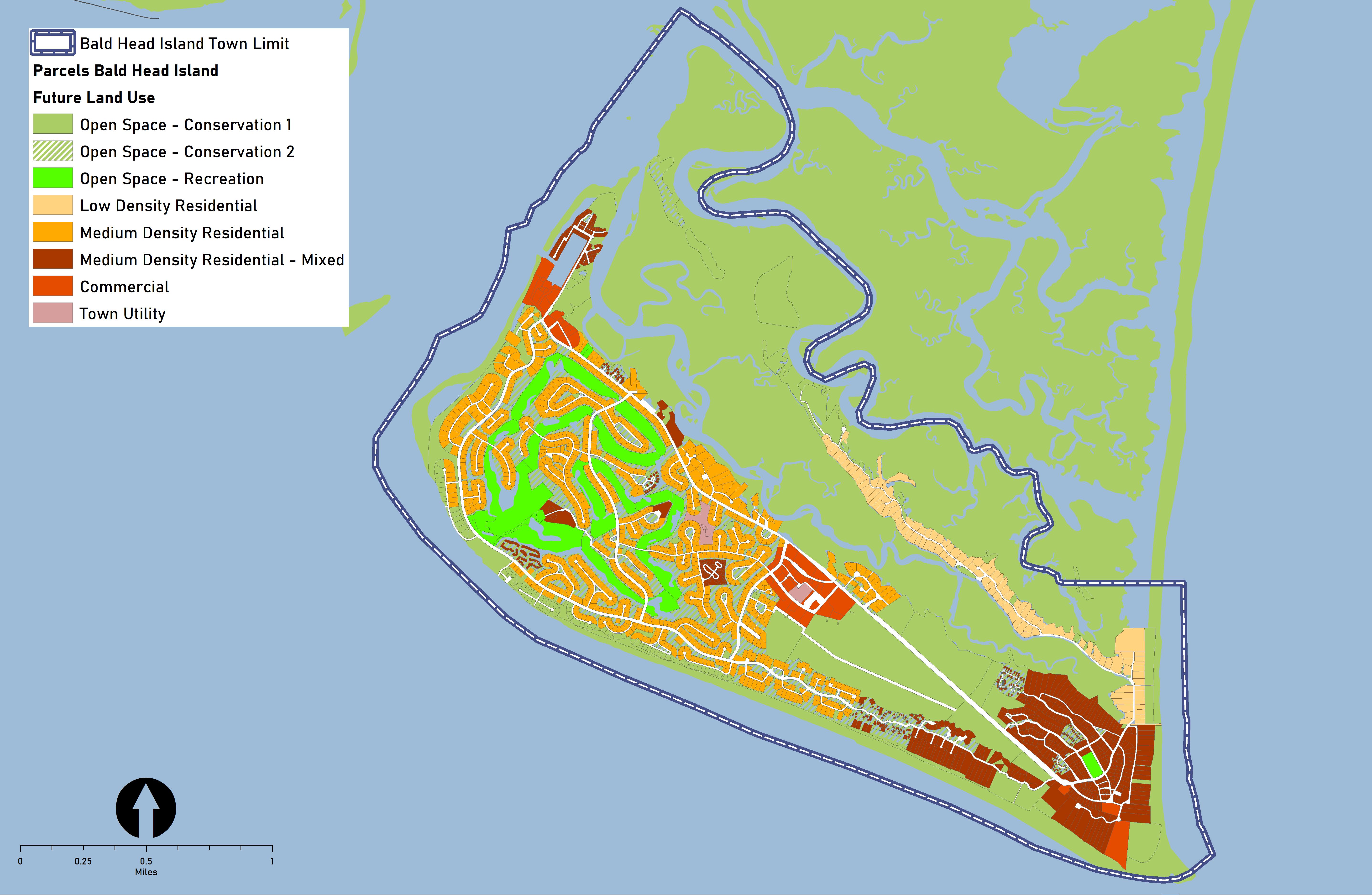
Future Land Use
The community’s vision for Bald Head Island is depicted on the Future Land Use and Conservation Map (Figure 10). The majority of the development pattern is envisioned to remain intact. Most of the new development in the future will consist of housing units on existing home lots. Through infill development and redevelopment in the current commercial nodes, the community will support a limited amount of additional nonresidential uses.
Note: The Place Type descriptions are presented on page ___ in Section 3 of Blueprint Brunswick 2040.
Policy Recommendations & Strategies
The following are a series of policy recommendations and supporting implementation strategies. As indicated in the column on the right, each has a connection to one or more of the recommendations outlined in Section 4 of Blueprint Brunswick 2040.
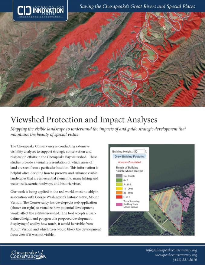
Chesapeake Conservancy Viewshed Studies: The Chesapeake Conservancy is conducting viewshed studies to help prioritize land for protection in the Chesapeake Bay watershed and protect signature views from scenic roads, hiking routes, and water trails.
Recommended Action Plan
Mebane Landscaping
Ordinance Updates: In 2022, the City of Mebane, NC updated its landscaping requirements and a variety of other ordinance standards to better match its expectations for new development.
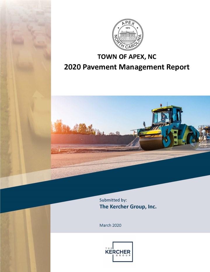
Apex Pavement Management Study: In 2020, the Town of Apex, NC conducted a pavement management study for Town streets using special software to estimate the cost of pavement improvements and identify which repairs would deliver the greatest benefit for the resources available.
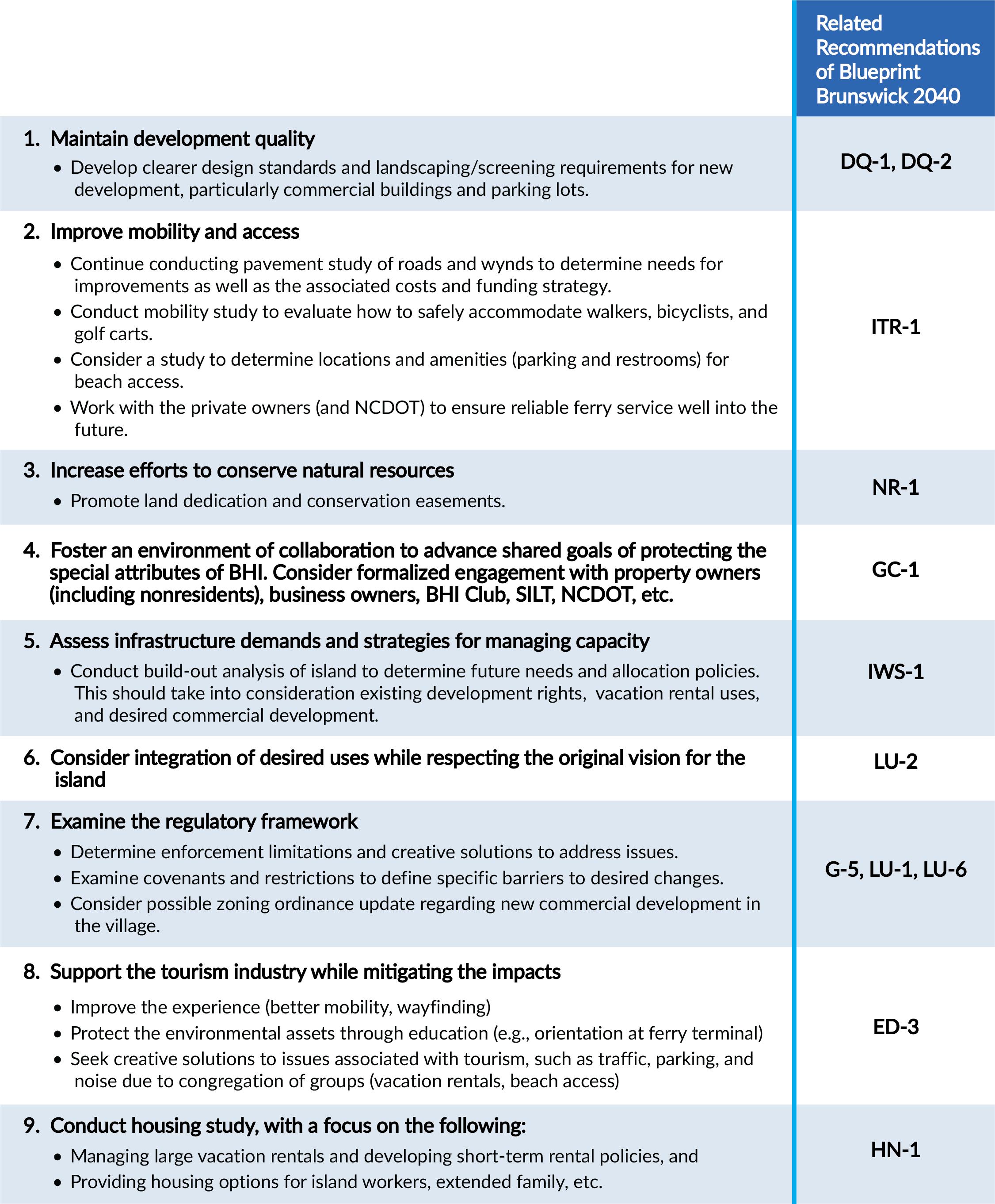
The conservation and development of Bald Head Island has always been about balance – enabling people to experience the special attributes of the place without degrading the qualities they came to see. As the island continues to develop on remaining vacant and underdeveloped lots, preserving the island’s natural qualities and mitigating the impacts of more people are paramount. As a result, the Village should prioritize the following action steps:
1 2 3
Clarify the rules that control new development: Update the Village Zoning Ordinance to clarify the screening requirements for new development, especially commercial buildings and parking lots; evaluate potential additions to permitted nonresidential uses in some zoning districts to meet the changing needs of the island.
Improve the condition and safety of roads and wynds: Continue conducting a pavement management study to identify location and cost of needed improvements to roads and wynds. Conduct a mobility study to improve the safety of walkers, bicyclists, and carts.
Protect the land that protects the island experience: Continue working with the Smith Island Land Trust and Bald Head Island Conservancy to identify and protect signature view-shaping lands and sensitive areas to maintain the island’s natural qualities as development continues.
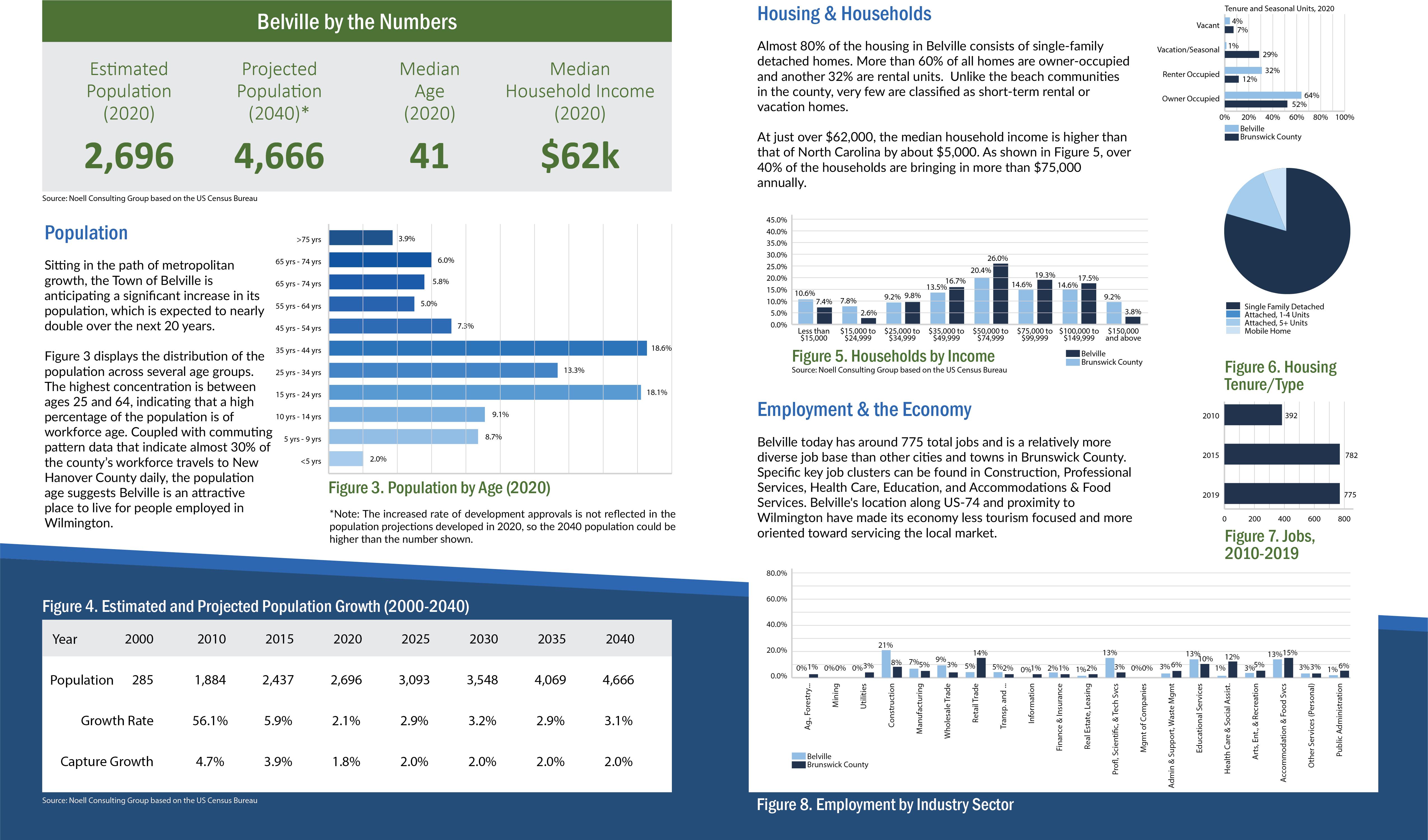
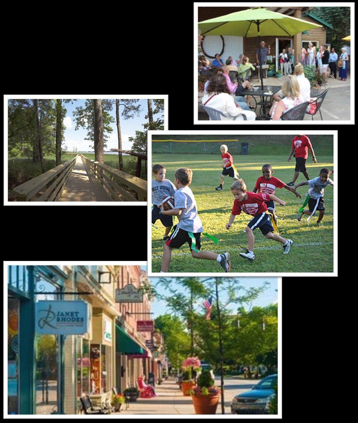
Incorporated in 1977, the Town of Belville is poised for development that is in response to demands for housing, commercial services, and industrial space in the greater Wilmington area. This plan builds on the work completed more than a decade ago and updated in 2021 to determine the vision for Belville’s downtown and waterfront area. The plan conveys ideas for future land use throughout the Town’s jurisdiction. Those ideas are supported by recommendations for policies and strategies for implementation over the next 20 years. The plan was created with thoughtful input of the Town’s elected and appointed officials, staff, and residents who attended the community meetings.
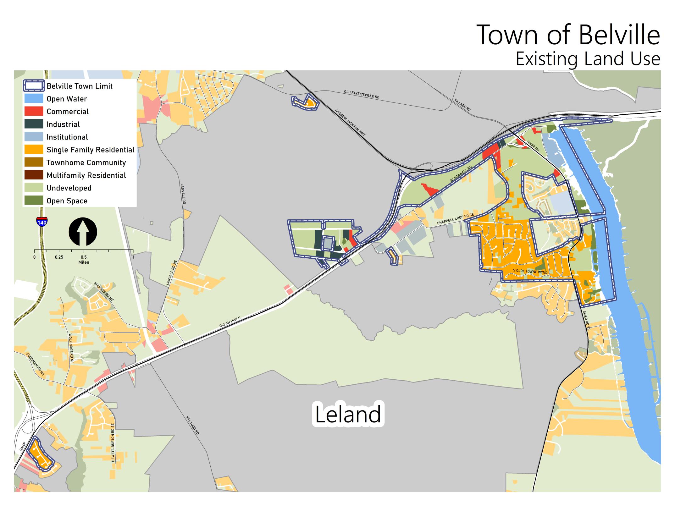
Existing Land Use & Development Pattern
Early development in the town included primarily industrial uses located to take advantage of access to the road network. More recently, development in neighboring Leland and nearby Wilmington is influencing land use changes in Belville. Today, most of the developed portions of the town are devoted to residential neighborhoods. Local- and region-serving commercial development is also part of the development pattern. Undeveloped and underdeveloped sites comprise 37% of the total land area, and some of it will support future development. However, 32% of the town’s jurisdiction is constrained by environmental features, including wetlands, floodplains, and high-risk flood areas and will likely remain as open space as the development pattern evolves over the next two decades.
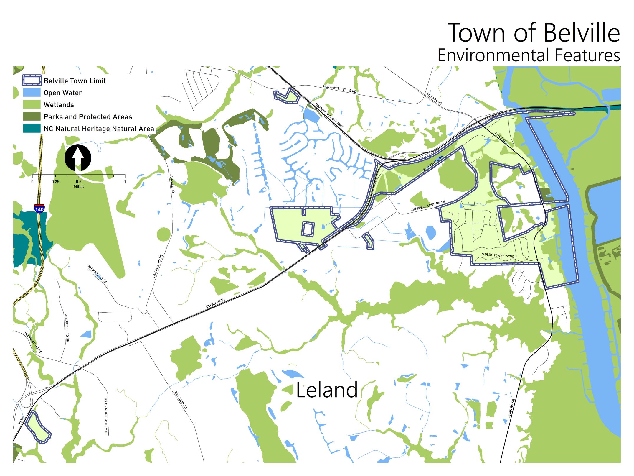
Environment
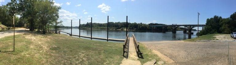
The town is located along the Brunswick River and some of its tributaries. As shown in Figure 2, most of the environmental features are creeks, floodplains, and wetlands. While these features present constraints to development, they are also the assets that can enhance development, providing areas for passive recreation as well as scenic views. Currently, the Town is pursuing funding to construct an extended “Riverwalk” greenway that leverages the visual and physical access to the river to provide a recreational destination within one of these environmentally sensitive areas.
Key Issues & Opportunities
Through the community engagement activities, the residents and other stakeholders shared concerns about future growth, anticipated changes to the development pattern, and potential impacts. While meeting participants and survey respondents identified several issues to be addressed in the coming years, they also highlighted some opportunities to consider as change occurs. The following summary reflects some the concerns and ideas expressed.
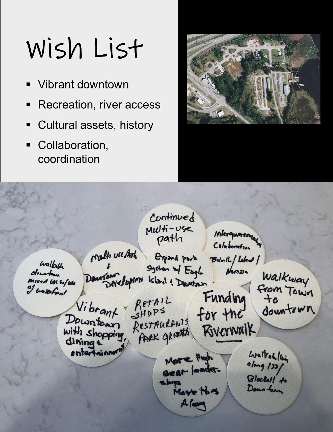
Downtown Development
Support has been building for the creation of a downtown that can support retail shops, restaurants, office, and civic uses. With open space along the waterfront and places for more public spaces that can support programmed events, the community anticipates opportunities for creating a destination to which residents and visitors will gravitate for social gatherings and entertainment. The concept was defined during the development of the Vision 2030 Plan. Citizens expressed support for partnerships the Town is forming with NCDOT, private property owners, and investors to facilitate the changes envisioned.
Traffic on NC-133
A NC Scenic Byway, NC-133 south of Belville offers views of natural areas and historic sites that contribute to the identity of Brunswick County. Traffic is building on this roadway that provides local access to neighborhoods and Belville Elementary School. The route is also a key connection between Wilmington and Southport, particularly for tourists. Meeting attendees shared concerns about safety for motorists exiting the neighborhoods as well as for pedestrians crossing to access the public park at the Riverwalk trailhead.
Active Recreation
While a few parks provide recreational opportunities within the town limits, most residents rely on the parks of neighboring jurisdictions and The County in meeting the full range of recreational needs. Those who participated in the planning process indicated support for improvements to existing public parks as well as new parks with ballfields, provided locations can be identified.
Community Engagement
During the Blueprint Brunswick 2040 planning process, Belville residents and property owners participated in district level meetings. In addition, community meetings were held in Belville in March and April of 2022. All such meetings were structured and facilitated to gather input on issues, opportunities and aspirations related to the future development pattern and conservation efforts. Feedback provided through online surveys augmented the input recorded at the in-person meetings.
Top-Ranked Goals
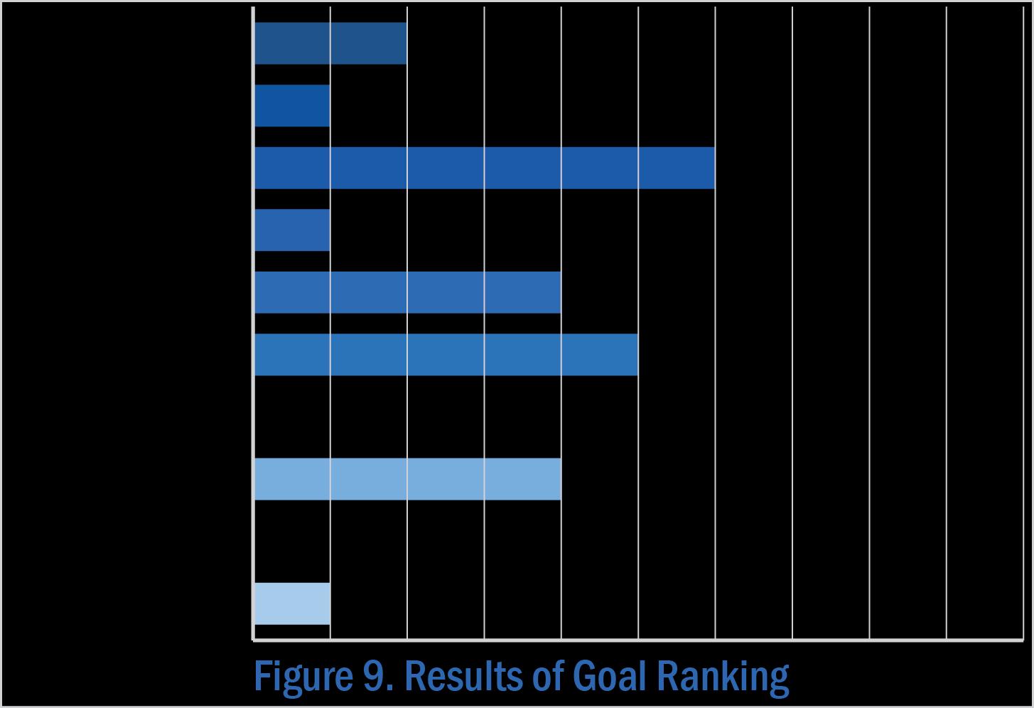
When asked to review the goals for the future of Brunswick County, meeting participants shared their opinions and voted for those they believe are most relevant to Belville. The goals pertaining to infrastructure and economic development ranked first and second, respectively. Goals related to historic, cultural, and scenic resources as well as development quality were also important.
Note: The full set of Goals are presented on page 68-69 in Section 3 of Blueprint Brunswick 2040.

Ideas for Land Use + Precedents
• Retail shops
• Restaurants
• Entertainment
• Parks, ballfields, greenspace, splash pad
• Riverwalk
Future Land Use
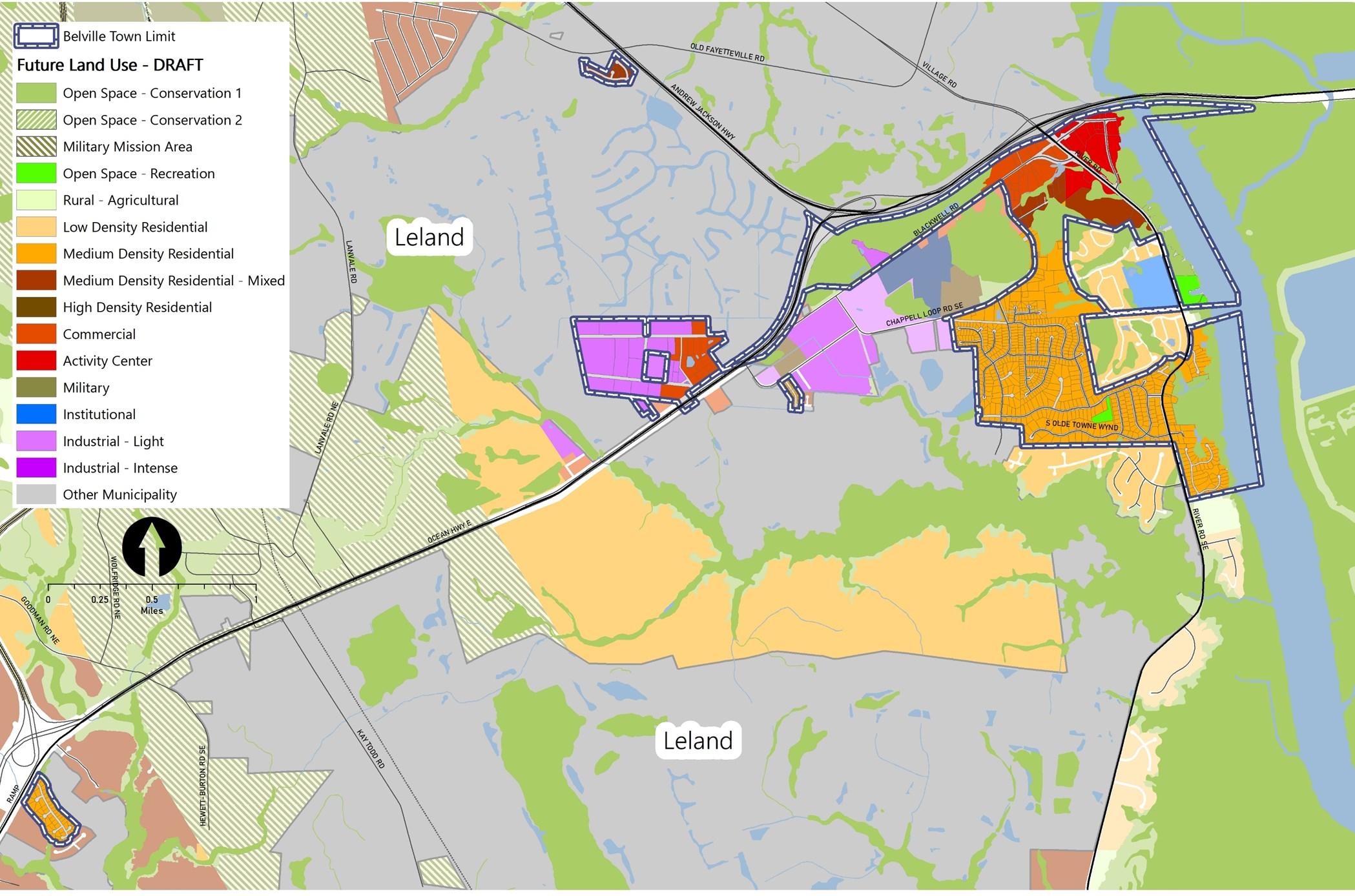
The focus of future development is the mix of uses, primarily commercial and civic, that are envisioned for the heart of the town. The development pattern depicted in the Future Land Use & Conservation Map (Figure 10) also indicates support for higher density residential as well as a desire for more employment uses supported by complementary commercial uses.
Note: The Place Type descriptions are presented on page 72 in Section 3 of Blueprint Brunswick 2040.
Policy Recommendations & Strategies
The following are a series of policy recommendations and supporting implementation strategies. As indicated in the column on the right, each has a connection to one or more of the recommendations outlined in Section 4 of Blueprint Brunswick 2040.
The Town of Knightdale, NC made $20 million in public investments in sidewalk, park, and streetscape improvements to leverage $250 million in private investment to date to revitalize its main street and create a vibrant center of community.
The Town of Cary and the Town of Morrisville, NC collaborated to secure federal funding to fill a gap in the Crabtree Creek Greenway, creating a continuous 4.5-mile segment of trail that now serves both communities.
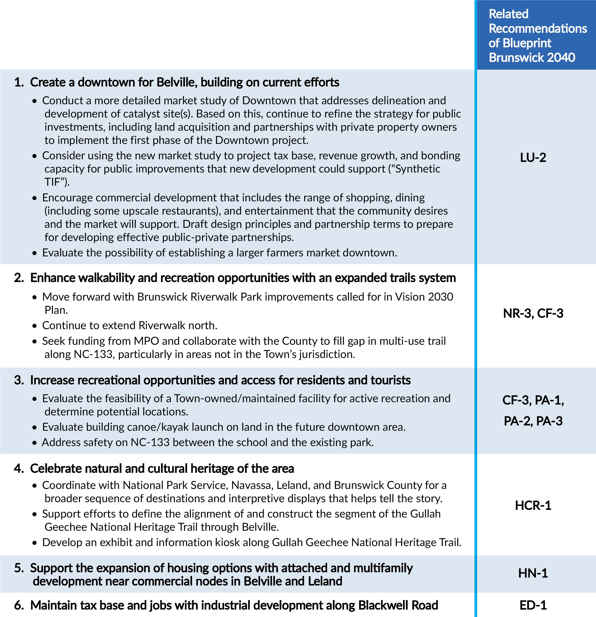
Recommended Action Plan
When a new bridge over the Brunswick River re-routed the main drag through town, Belville lost its downtown. Now, it is working to re-establish a vibrant civic and commercial center for the community. At the same time, the Town is working to create a linked network of trails and greenways and tell the story of the community.
1 2 3
Set the table for public and private investment downtown. Key steps in advancing the reestablishment of a vibrant downtown include identifying some catalyst sites, acquiring land, and drafting design principles and preliminary partnership terms to prepare for developing effective public-private partnerships with private property owners and developers. A more detailed market study and revenue and bonding analysis could help support this work.
Continue creating a linked network of parks and trails. Belville has had great success securing grant funds to leverage Town investment in the Riverwalk. It can build on its accomplishments by locating the next installments of grant funding to continue the job to extend the Riverwalk north, improve the Riverwalk park, and work with The County to fill a gap in the multi-use trail on NC 133.
Develop new recreational facilities. The construction of a second canoe/kayak launch at the Downtown site would enable paddlers to make trips between there and the Riverwalk Park. The Town should also study creation of a facility for active recreation, and address safety crossing NC133 to the school.
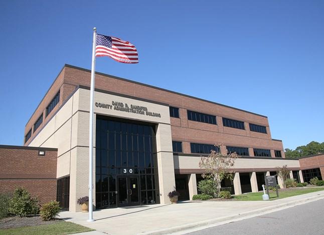
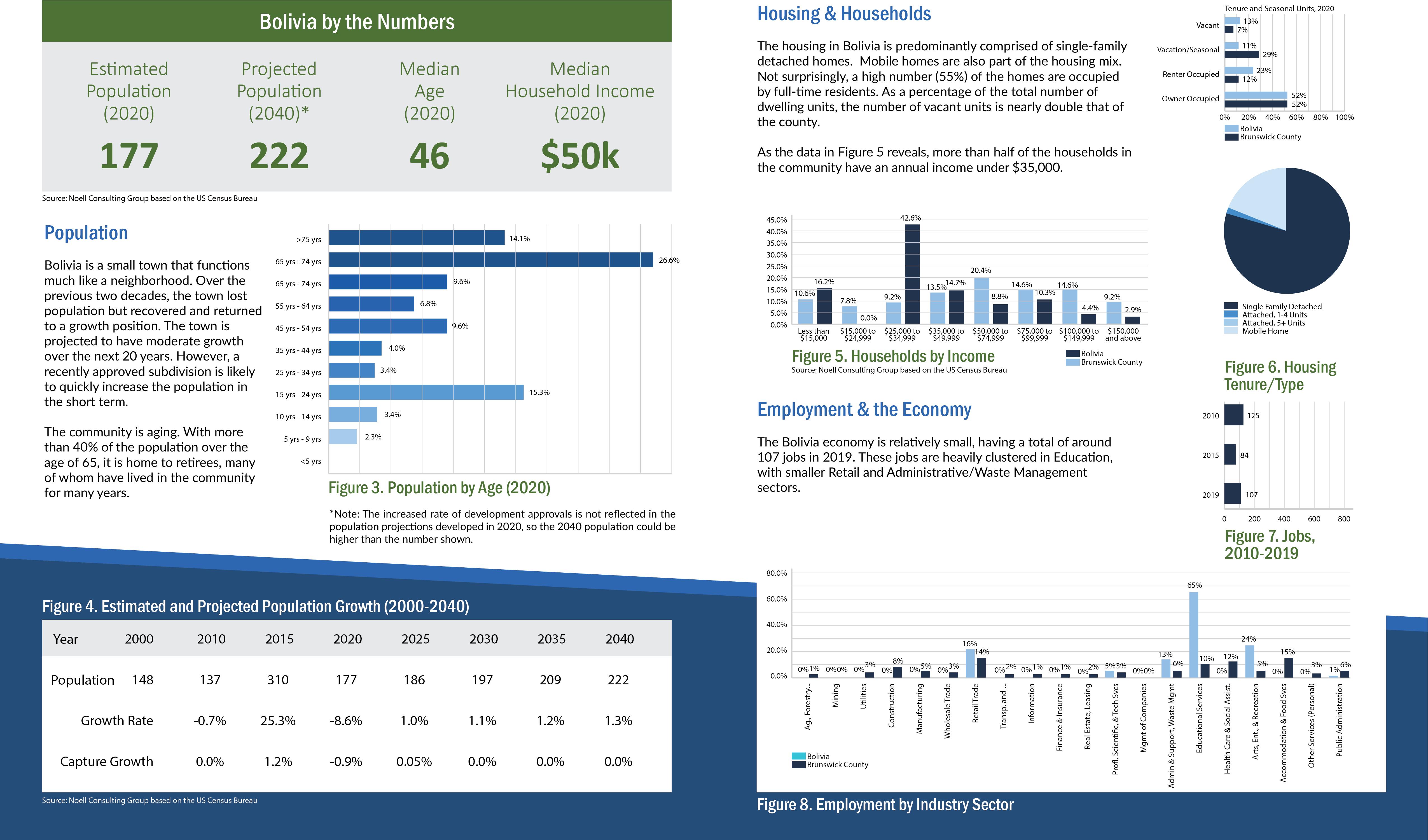
Bolivia is the seat of Brunswick County. As such, it is the location of the County Government Complex. Though the growth has been slow, the town aspires to become a family-friendly community with places and activities that bring residents of all ages together. This plan sets the stage for change that will meet the needs of the existing community, introduce uses that will attract more private investment, and preserve the natural features that are part of the community landscape. The plan conveys ideas for future land use throughout the Town’s jurisdiction. Those ideas are supported by recommendations for policies and strategies for implementation over the next 20 years. The plan was created with thoughtful input of the Town’s elected and appointed officials, staff, and residents who attended the community meetings.
Existing Land Use & Development Pattern
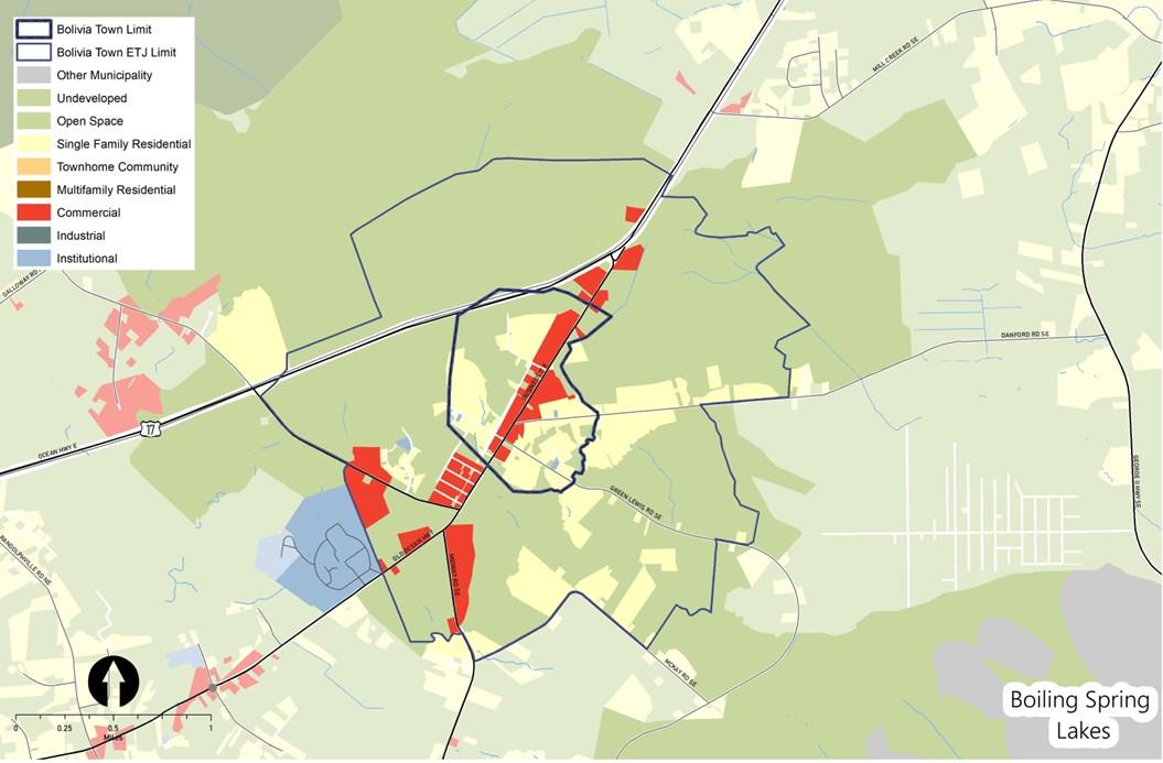
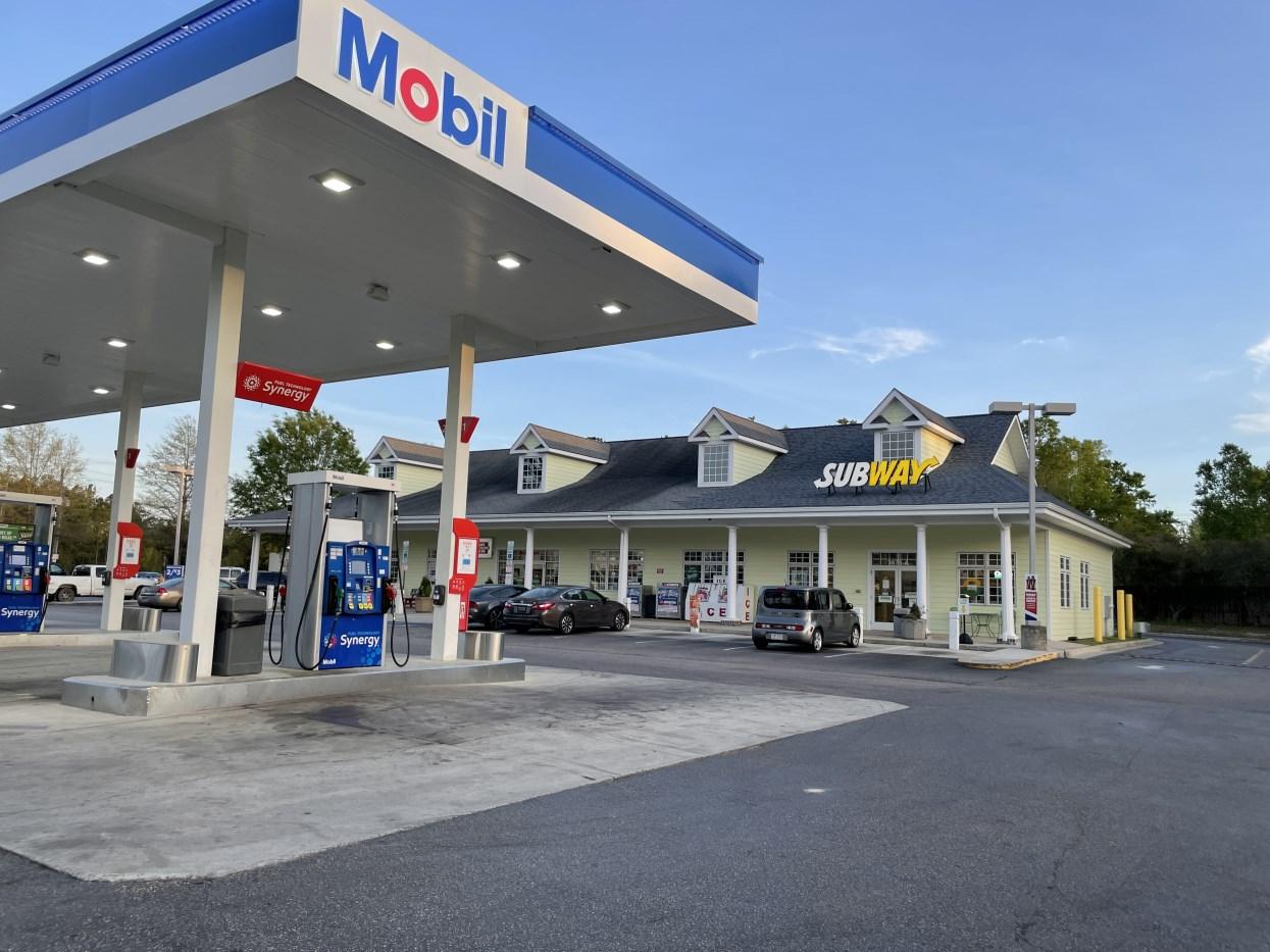
Most of the jurisdictional area of Bolivia is developed for low density residential and commercial uses. Many of the commercial uses are oriented toward US-17 Business, which functions as the town’s main street. Just outside of the Town limits and inside the Town’s extraterritorial jurisdiction (ETJ), the land has remained relatively undeveloped. The Government Complex encompasses almost 140 acres, which is equal to almost half the area of the Town and is in the unincorporated area of The County.
Environment
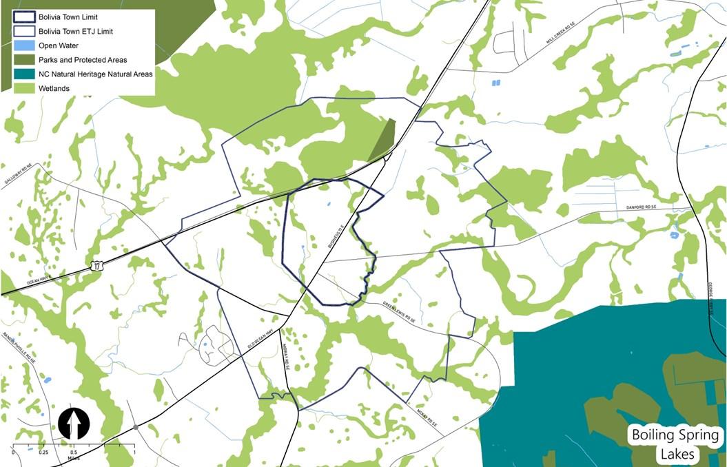
Wetlands and creeks are the primary natural features that, together, generally define the northern and southern edges of the town. The wetlands on the north side of town are extensive and particularly challenging for development. Therefore, future changes in the development pattern will be limited to the southern side of US-17. The locations of wetlands and creek corridors lend themselves to passive recreation opportunities.
Key Issues & Opportunities
Through the community engagement activities, the residents and other stakeholders shared concerns about future growth, anticipated changes to the development pattern, and potential impacts. While meeting participants and survey respondents identified several issues to be addressed in the coming years, they also highlighted some opportunities to consider as change occurs. The following summary reflects the concerns and ideas expressed.
Community Engagement and Gathering Spaces
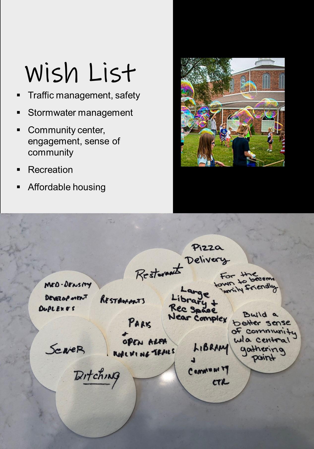
In a small town with a limited budget, engagement of residents in leadership, social events, and other community-focused activities can be challenging. The citizens that participated in the planning process noted opportunities to leverage the presence of county government to expand civic spaces and amenities. Such investments are viewed as a step toward more programming that could foster connections between neighbors.
Aging
To stay in the community over the long term, some residents recognize the need for support services, such as home health, and housing that is appropriate for senior living. This coupled with efforts to build a sense of community and attract younger people, are considered to be the necessary steps to helping residents age in place.
Traffic and Circulation
The roads through this community support not only local traffic but that which is generated by people traveling between US-17 and destinations at the waterfront, including Oak Island and Southport. The configuration of the road network forces most vehicles onto segments of US-17 (Old Ocean Highway) in the center of Bolivia, creating high levels of congestion. Residents have expressed interest in better connectivity, traffic management techniques and road realignments to alleviate some of the issues.
Stormwater
Stormwater conveyance is primarily handled by ditches and culverts along the roadways, so NCDOT has maintenance responsibility. Going forward, residents are concerned the flooding caused by obstructions in the system (i.e., litter, debris, beaver dams, etc.) will increase if a more proactive approach to managing these facilities or stormwater in general is not employed.
Community Engagement
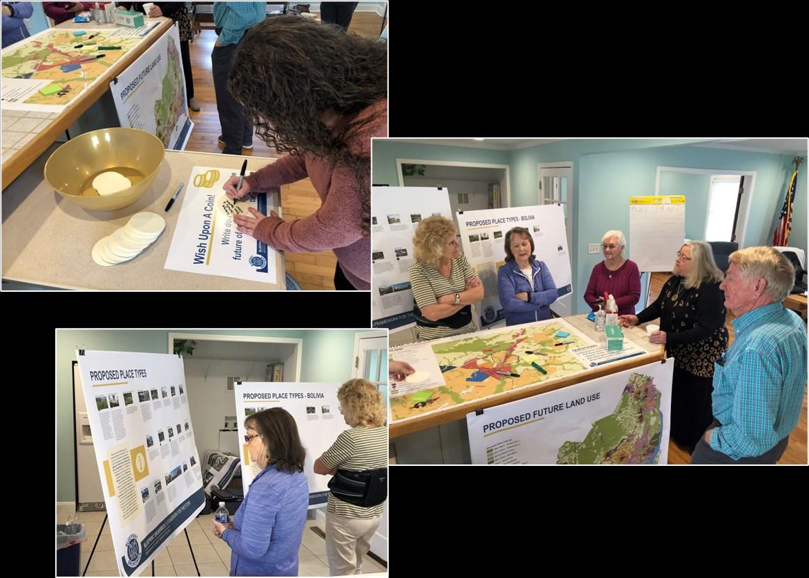
During the Blueprint Brunswick 2040 planning process, Bolivia residents and property owners participated in district level meetings. In addition, community meetings were held in Bolivia in March and April of 2022. All such meetings were structured and facilitated to gather input on issues, opportunities and aspirations related to the future development pattern and conservation efforts. Feedback provided through online surveys augmented the input recorded at the in-person meetings.
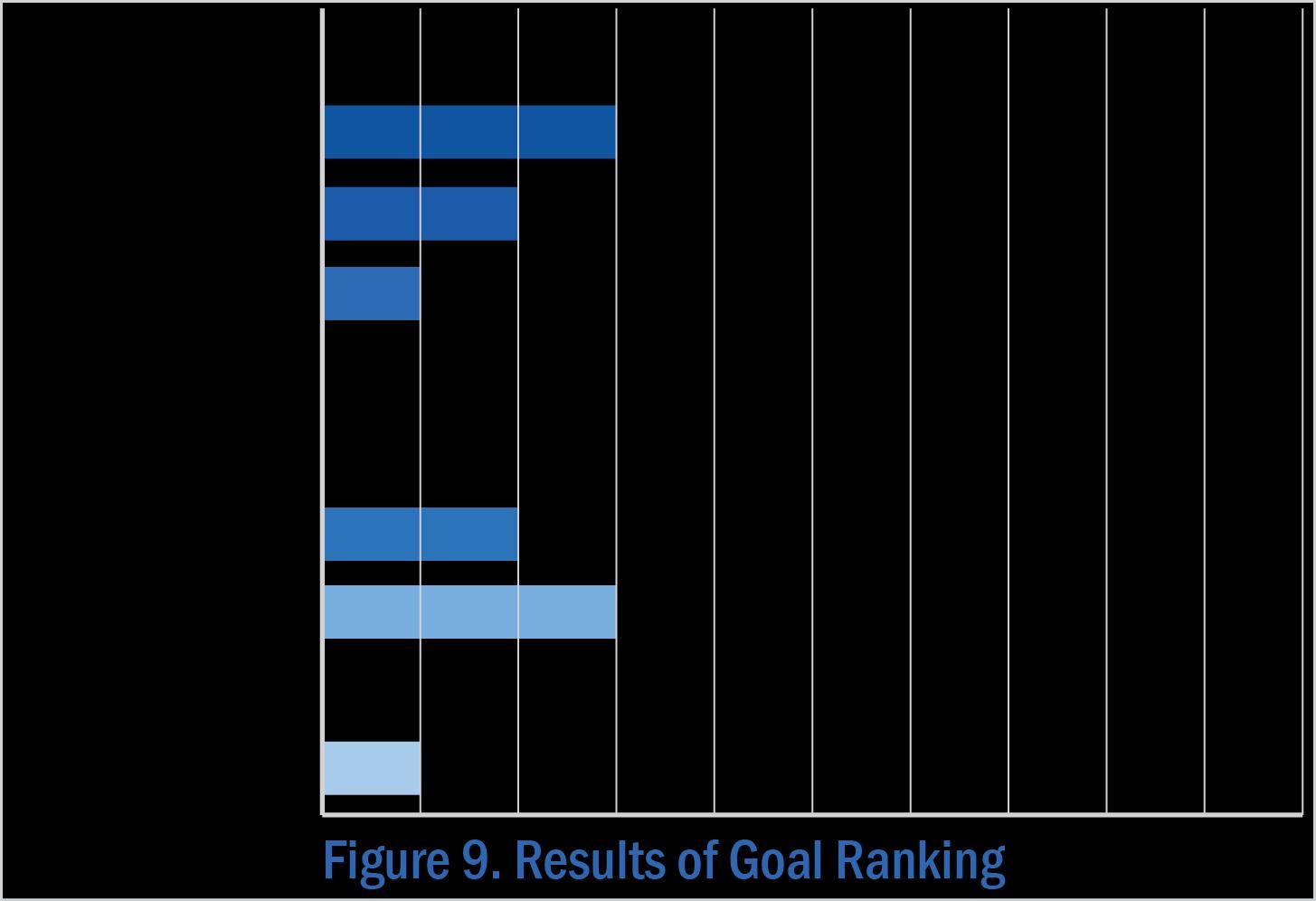
Top-Ranked Goals
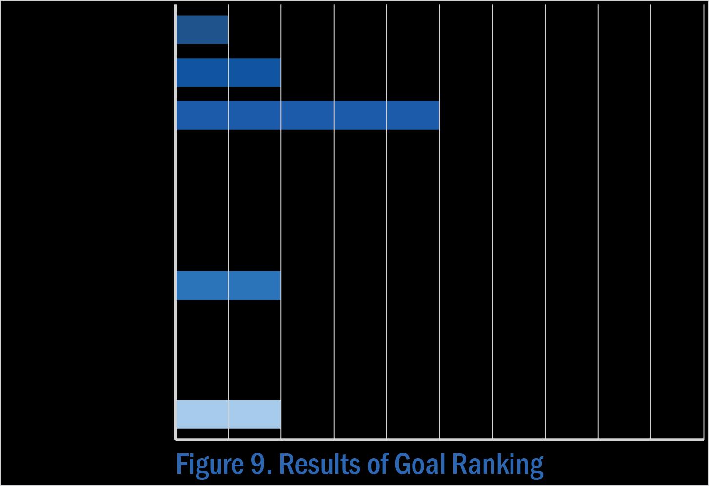
When asked to review the goals for the future of Brunswick County, meeting participants shared their opinions and voted for those they believe are most relevant to Bolivia. The goal pertaining to infrastructure, ranked highest in importance. Goals related to the environment, housing, and governmental coordination were given equal weight.
Note: The full set of Goals are presented on page 68-69 in Section 3 of Blueprint Brunswick 2040.
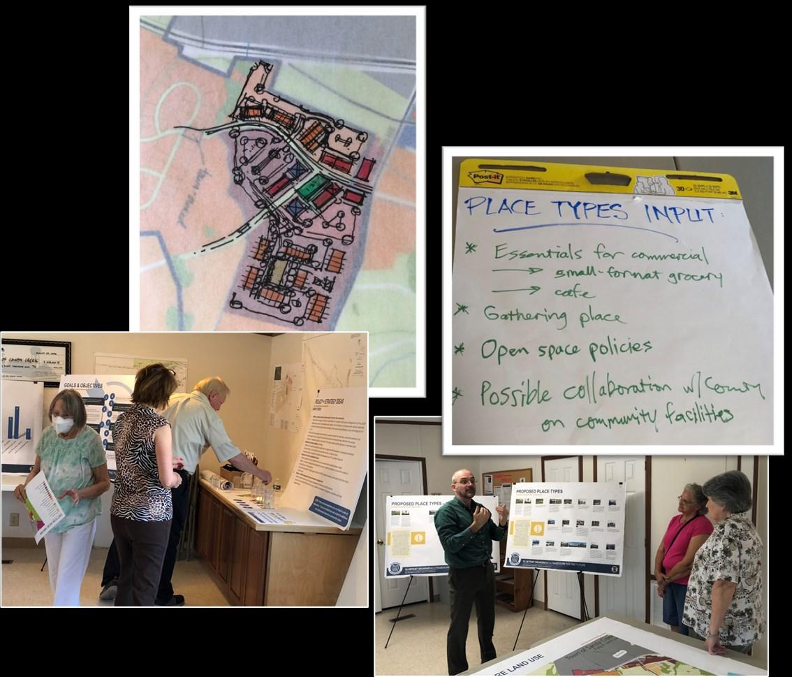
Ideas for Land Use + Precedents
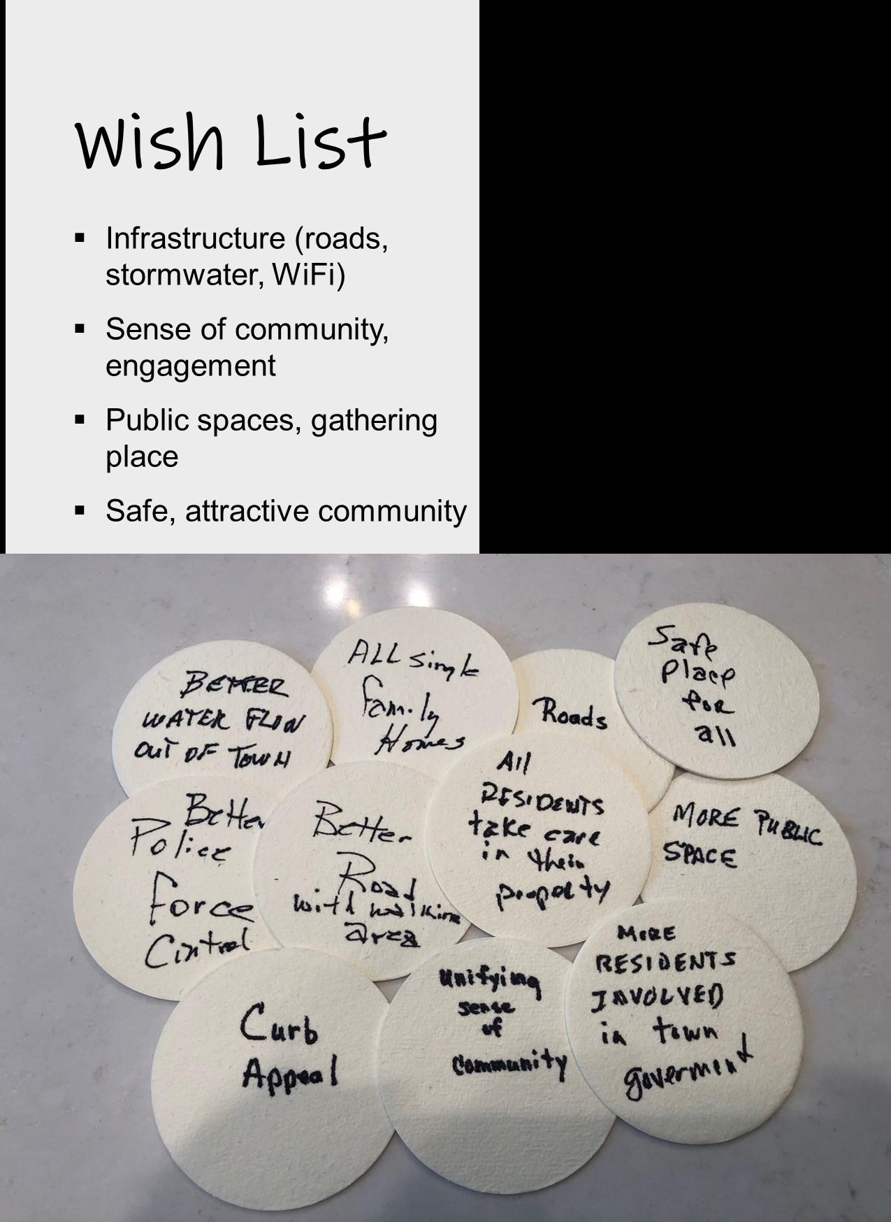
• Central gathering place
• Library (large), community center
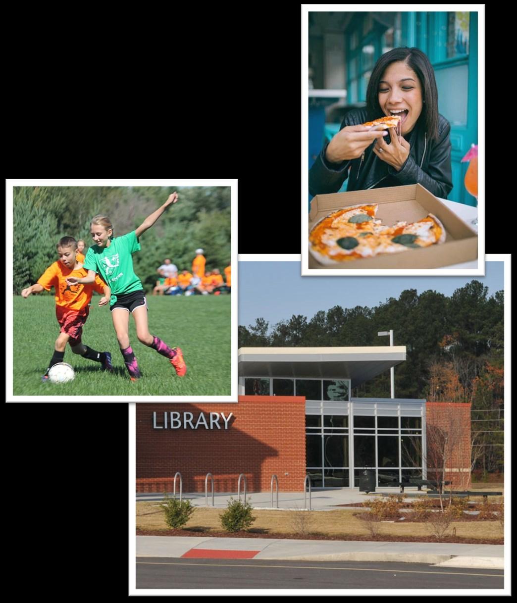
• Recreation space (maybe near government complex)
• Parks, open area, walking trails
• Food service: restaurants, pizza delivery
• Medium-density residential development (apartments, duplexes)
• Neighborhood commercial
• Senior Center
Future Land Use
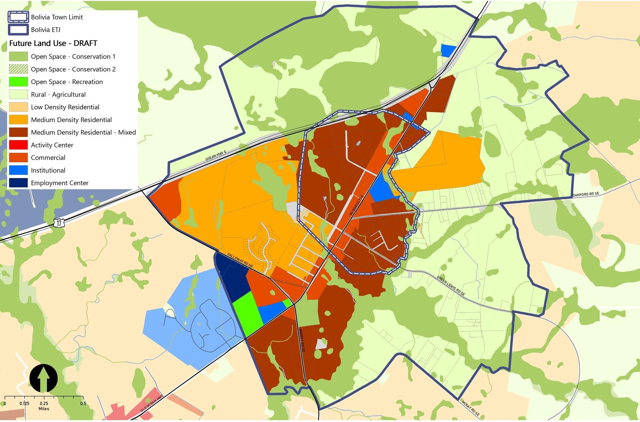
The Future Land Use & Conservation Map (Figure 10) depicts the community’s vision for future development pattern. Key aspects of the plan are the concentration of commercial development along the main street and around a proposed new alignment of Galloway Road intersection serving the resident, employees, and visitors passing through from Southport and Oak Island; a civic and recreational complex with community green space designed for gatherings and events; and opportunities for higher density housing to expand choices in town, particularly for older residents and essential workers in the County.
Note: The Place Type descriptions are presented on page 72 in Section 3 of Blueprint Brunswick 2040.
Policy Recommendations & Strategies
The following are a series of policy recommendations and supporting implementation strategies. As indicated in the column on the right, each has a connection to one or more of the recommendations outlined in Section 4 of Blueprint Brunswick 2040.
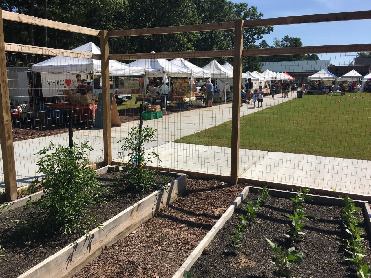
The Town of Morrisville, NC partnered with the Western Wake Farmers, the Morrisville Community Garden, and the John Rex Endowment to construct a farmers market site and demonstration community garden at a major intersection of the local greenway network to promote physical activity and access to healthy food.
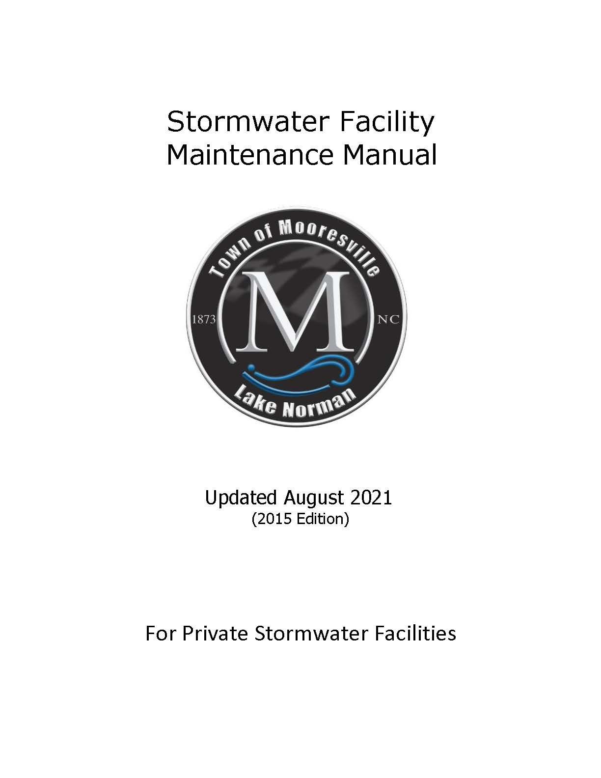
The Town of Mooresville, NC has developed a Stormwater Facility Maintenance Manual for private stormwater facilities to help property owners ensure the continued functioning of drainage ditches and other stormwater control measures.
Recommended Action Plan
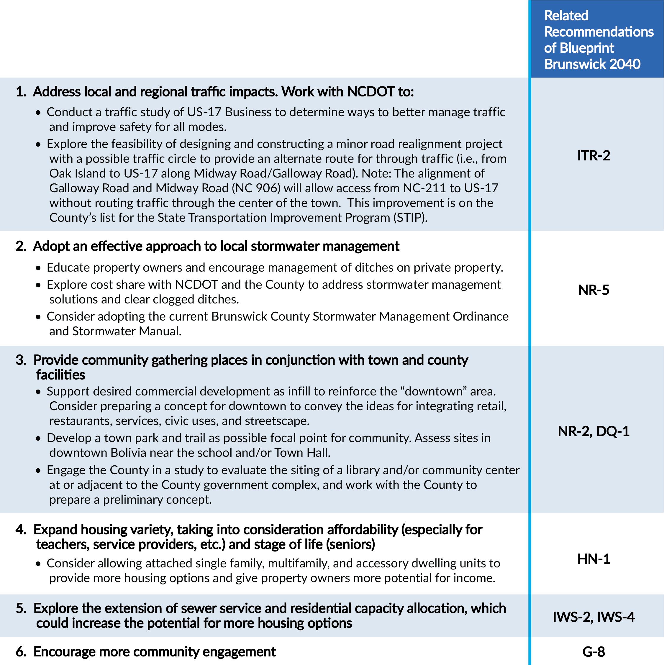
As Brunswick County and Bolivia grow, they face increasing challenges with traffic congestion and stormwater runoff. At the same time, new development brings new opportunities, such as a chance for the Town to leverage growth to strengthen the downtown area, provide new amenities like parks and trails, and work with partners like the County to construct desired community facilities. As a result, the Town will pursue the following priorities:
1 2 3
Improve the road system: Work with the County, the Cape Fear RPO, and/or NCDOT to conduct a traffic study of US-17 Business and assess the feasibility of a minor road realignment project with a possible traffic circle to provide an alternate route for through traffic (i.e., from Oak Island to US-17 along Midway Road/Galloway Road).
Ensure proper design and maintenance of stormwater facilities: Educate property owners about good stormwater maintenance practices, work with the County and NCDOT to provide stormwater management assistance and clear clogged ditches, and consider adopting the current Brunswick Stormwater Management Ordinance and Stormwater Manual, and continuing to arrange to have the County administer it.
Strengthen downtown and provide community gathering spaces: Support desired commercial development as infill downtown, build a park and trail as a community gathering; update the development ordinance to establish a parkland dedication requirement or fee in lieu of dedication and allow for accessory dwelling units; and engage the County in studying the possible siting of a library/community center next to the County government complex.
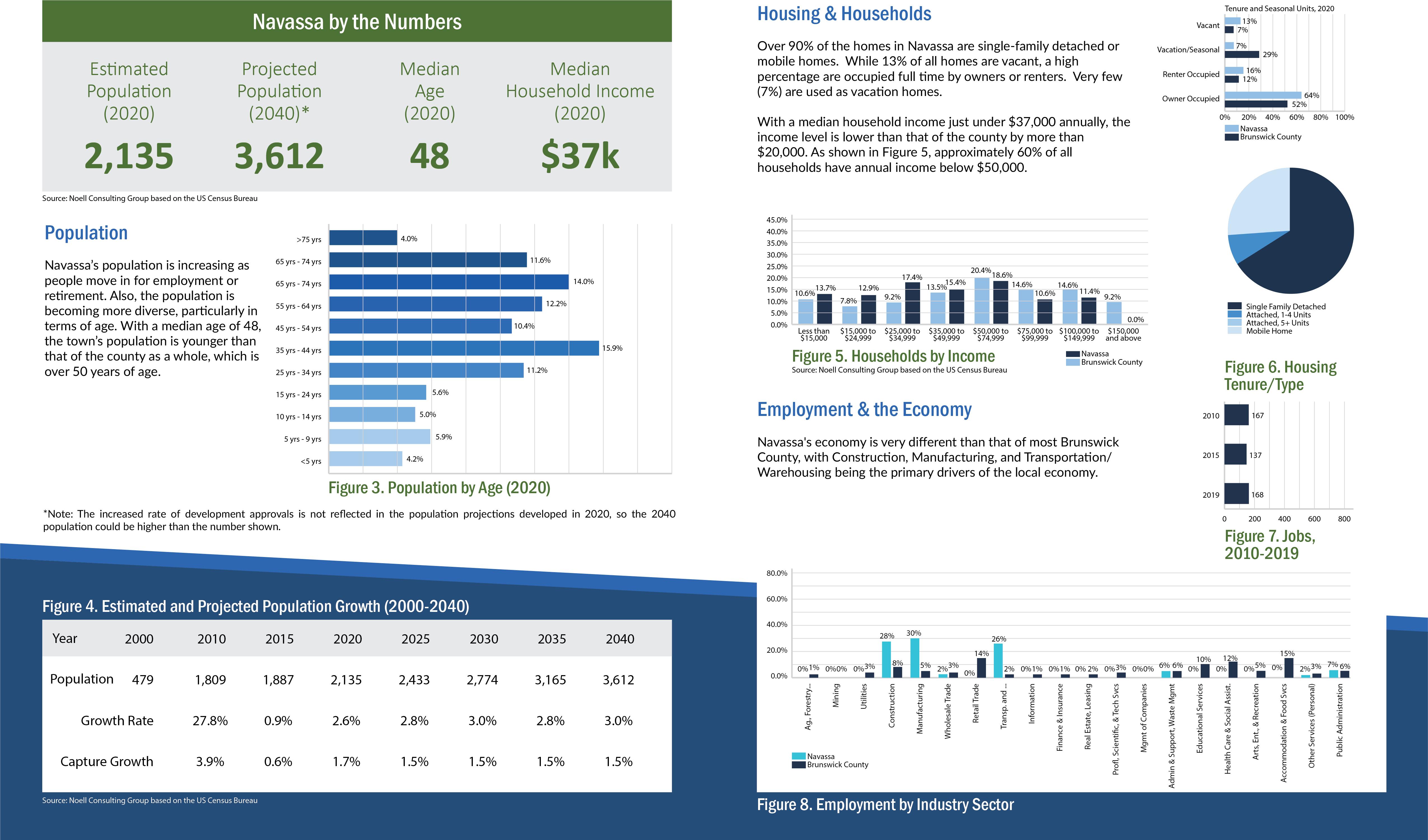
Incorporated in 1977, the Town of Navassa is positioned for development that is in response to demands for housing, commercial services, and industrial space in the Wilmington area. This plan conveys ideas for future land use throughout the Town’s jurisdiction while emphasizing opportunities for conservation of the town’s rich history and culture. Those ideas are supported by recommendations for policies and strategies for implementation over the next 20 years. The plan was created with thoughtful input of the Town’s elected and appointed officials, staff, and residents who attended the community meetings.
Existing Land Use & Development Pattern
From rice plantations to fertilizer production to modern residential and industrial development, Navassa’s development pattern has been evolving for more than three centuries. Prior to the introduction of the automobile, boat and rail trade routes that eventually connected to Wilmington’s seaport, influenced the location of development in the 19th century. Rice plantations and fertilizer plants were among the uses. Over time, highway access has shaped the development pattern, bringing more opportunities for commercial and residential development, particularly near the I-140 interchanges. The town is now experiencing an increase in private investment. New residential neighborhoods between the industrial sites at the northern and southern parts of the town are being constructed to meet the growing demand in the region for housing. The town has an opportunity to harness the current and projected growth to realize some desired land use changes that could result in economic benefits for the community.
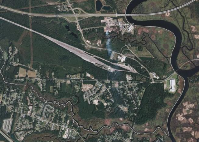
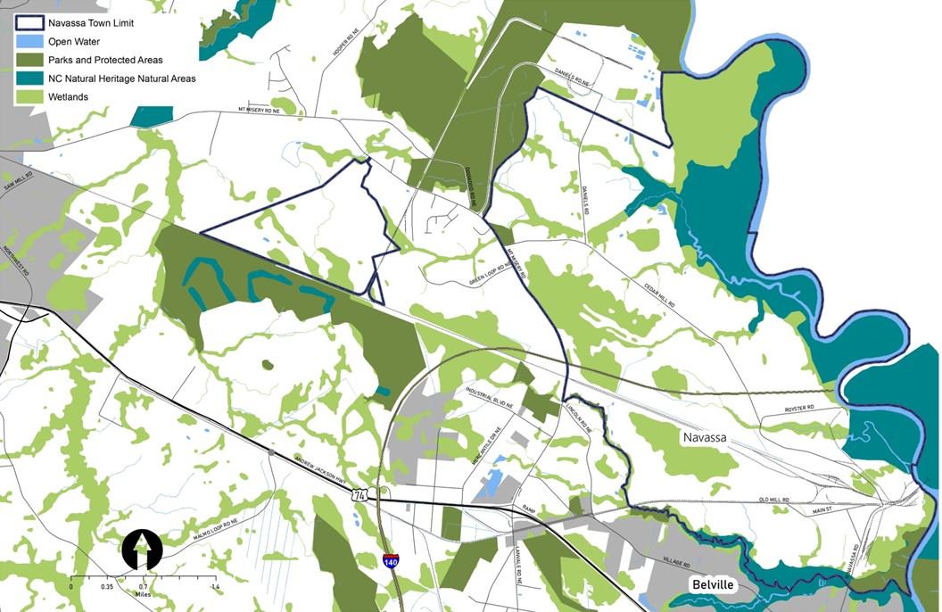
Environment
The natural heritage of the area is in some ways as rich as the cultural heritage. Located on the west side of the Cape Fear River, the town has many contiguous acres of wetlands, which serve as important habitat for a wide variety of plant and animal species. Just outside the town limits are NC Natural Heritage Program areas that are valued for their biodiversity, as they “contain the best rare species populations, habitats, and communities.”
Key Issues & Opportunities
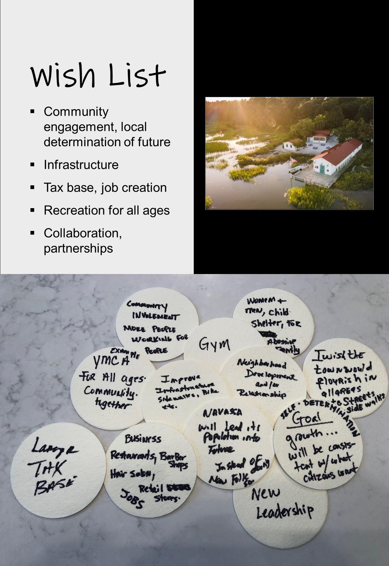
Through the community engagement activities, the residents and other stakeholders shared concerns about future growth, anticipated changes to the development pattern, and potential impacts. While meeting participants and survey respondents identified several issues to be addressed in the coming years, they also highlighted some opportunities to consider as change occurs. The following summary reflects some of the concerns and ideas expressed.
Economic Development
Increasing the local tax base and expanding job opportunities in the community are among the primary interests of the citizens of Navassa. The community boasts a history of high employment when the fertilizer plants and other industries were in operation. Ideas shared by members of the community included leveraging the access through new interchanges along I-140 and utilizing the existing industrial sites to support more nonresidential development.
Infrastructure
From broadband to transportation, the desires of the community as expressed by meeting attendees include a wide range of infrastructure improvements. Understanding that expansions and upgrades across all systems will attract the investments that will improve the economic conditions of the community, the citizens favor changes that will result in equitable access to facilities and services.
Pairing Cultural and Recreational Assets
The story of the town’s rich history can be told as visitors enjoy the waterfront as a recreational amenity. Participating in the implementation of plans to create the Gullah Geechee National Heritage Trail is viewed as an opportunity to be more connected locally and regionally while raising awareness of and celebrating the community’s unique past.
Community Involvement
As the population grows and diversifies, community members are keenly aware of the need to engage residents, including those who are young or new to the town, in taking leadership roles and advancing the interests of the town.
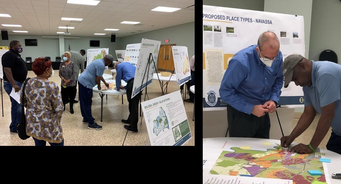
Community Engagement
During the Blueprint Brunswick 2040 planning process, Navassa residents and property owners participated in district level meetings. In addition, community meetings were held in Navassa in March and April of 2022. All such meetings were structured and facilitated to gather input on issues, opportunities and aspirations related to the future development pattern and conservation efforts. Feedback provided through online surveys augmented the input recorded at the in-person meetings.
Top-Ranked Goals
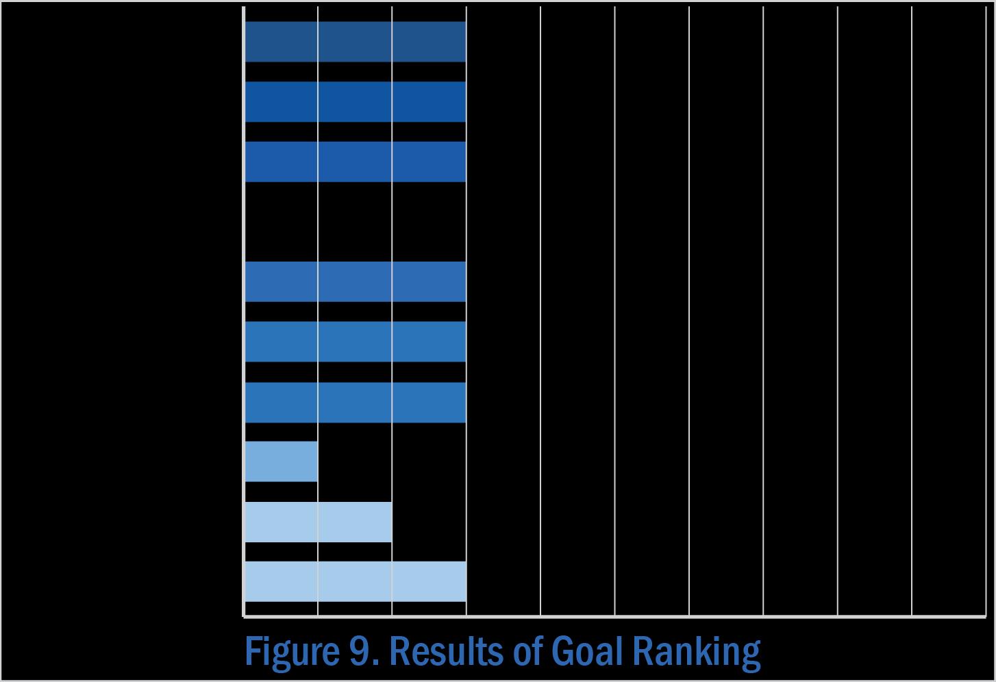
When asked to review the goals for the future of Brunswick County, meeting participants shared their opinions and voted for those they believe are most relevant to Navassa. All but public access to water, development quality, and health and well-being were deemed to be equally important.
Note: The full set of Goals are presented on page 68-69 in Section 3 of Blueprint Brunswick 2040.
Ideas for Land Use + Precedents
• Restaurant
• Retail, shops
• Personal services (barber, hair salon)
• Entertainment
• Industrial (for tax base and job creation)
• Affordable housing
• Shelters (domestic abuse)
• Recreation facilities—one in district 3 on Cedar Hill Rd. (with new development); behind Town Hall for Districts 1 & 2
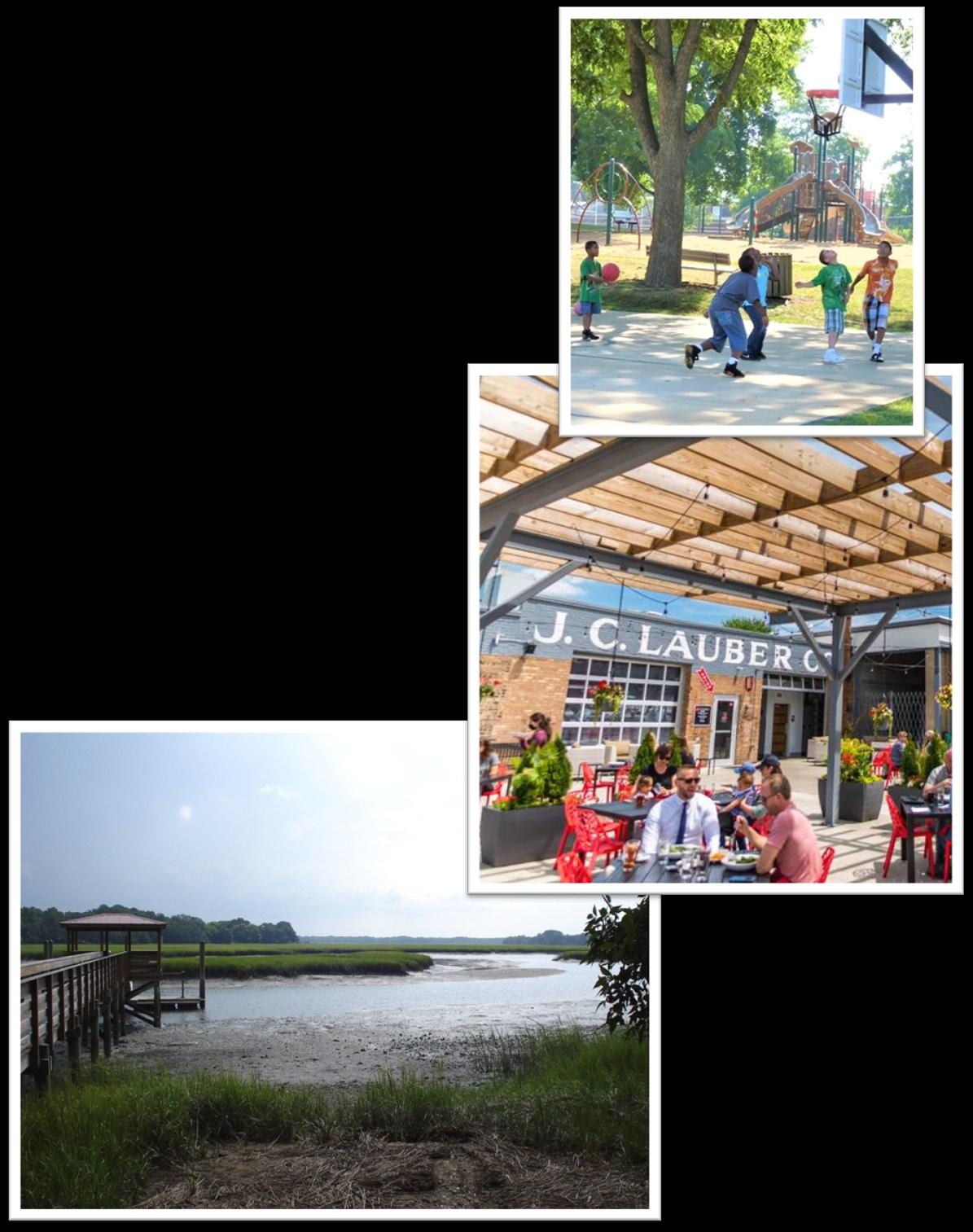
• YMCA, gym
• Parks, splash pad
• Library, community center
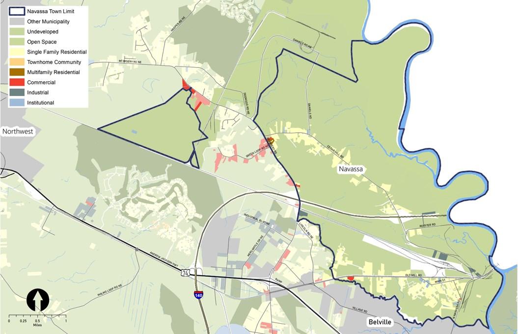
Future Land Use
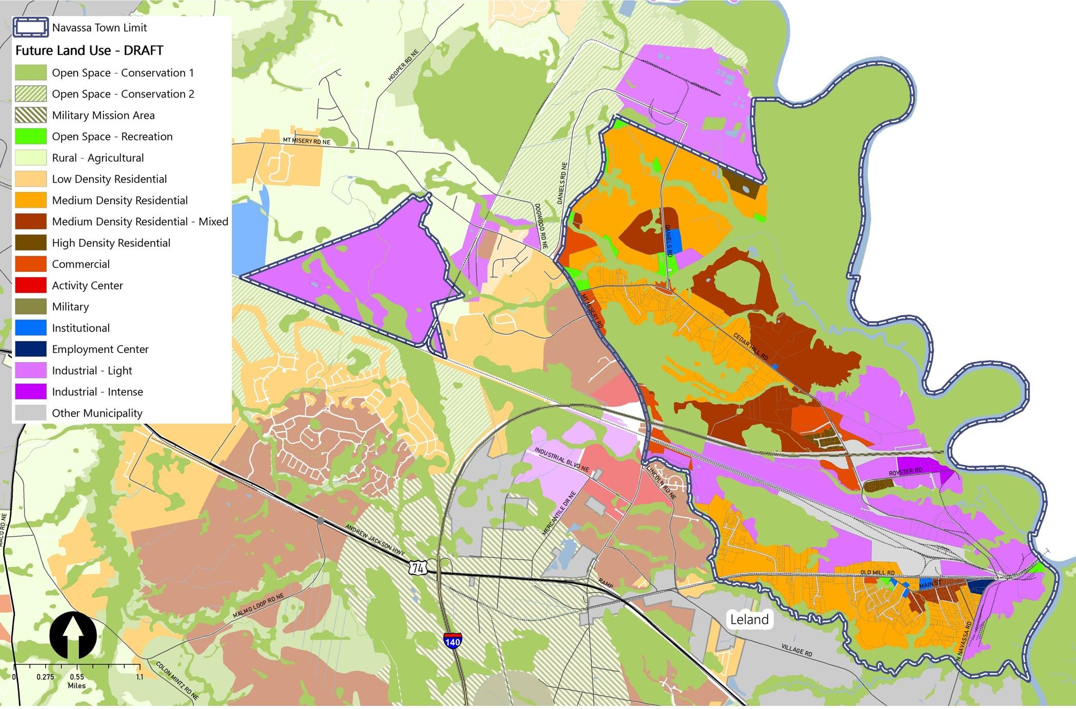
The vision for the future of the community emphasizes private investment in existing and future industrial development. Recognizing the growth that is already occurring in the town, the community’s vision also indicates support for new residential development that includes affordable housing, local-serving commercial development, and areas for passive and active recreation.
Note: The Place Type descriptions are presented on page 72 in Section 3 of Blueprint Brunswick 2040.
Policy Recommendations & Strategies
The following are a series of policy recommendations and supporting implementation strategies. As indicated in the column on the right, each has a connection to one or more of the recommendations outlined in Section 4 of Blueprint Brunswick 2040.
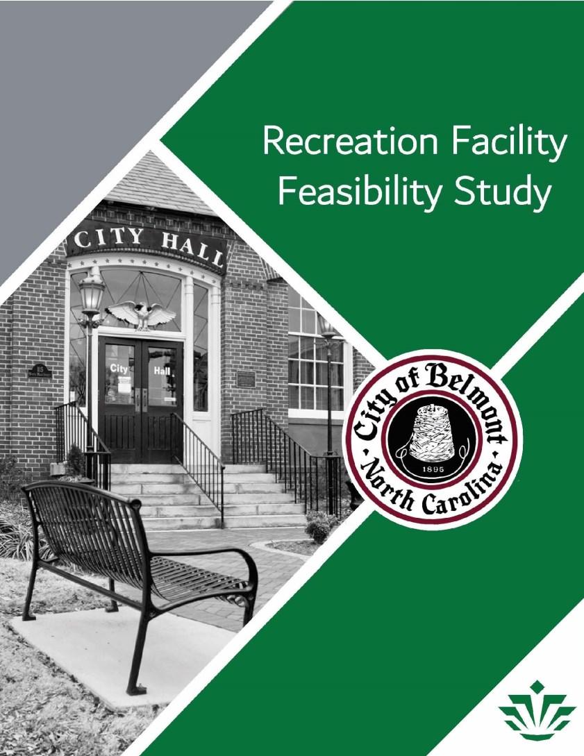
Belmont Recreation Center Feasibility Study: In 2018, the City of Belmont, NC engaged a class from the Master of Public Administration program at the University of North Carolina at Charlotte to prepare a feasibility study for a new recreation facility. The students conducted a survey and analysis to assess community needs, identify what type of facility would be most beneficial, and estimate construction and operating costs.
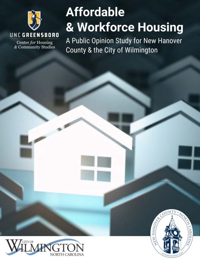
New Hanover County/Wilmington Affordable Housing Study: In 2021, the UNC Greensboro Center for Housing & Community Studies prepared an affordable housing report for New Hanover County and the City of Wilmington, with significant public input and recommendations on how to address the issue. This could serve as a model for Brunswick County.
Recommended Action Plan
Navassa is a small town near Wilmington that is working to improve life for its residents and celebrate its longstanding African-American history as it grows. The Town has been skilled at securing state and federal grants to improve its infrastructure, and should draw on these skills and connections to implement the goals of this plan.
1 2 3
Chattahoochee, FL Park and Trail Improvement Study: The Rivers, Trails, and Conservation Assistance program of the National Park Service is working with the City of Chattahoochee, FL to study how to improve recreational amenities, build a heritage trail, and protect the archeological resources at River Landing Park on the Apalachicola River. (Photo courtesy of City of Chattahoochee, FL) 4
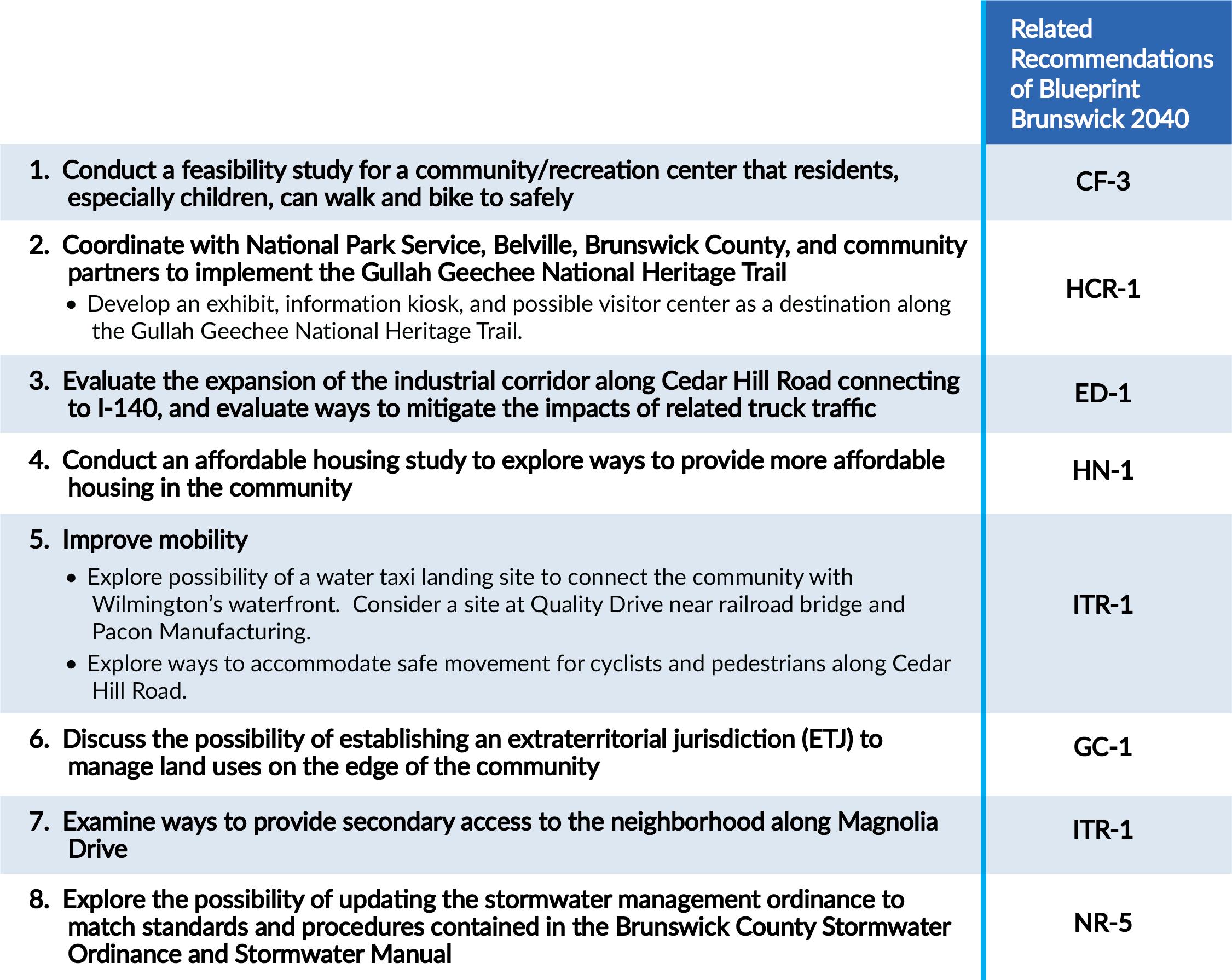
Conduct a feasibility study for a community/recreation center that residents, especially children, can walk and bike to safely. Identify appropriate facility features, location, safe connections to the community, projected cost, and potential funding sources.
Coordinate with National Park Service, Belville, Brunswick County, and community partners to implement the Gullah Geechee National Heritage Trail. The Town should build on its existing efforts to develop an exhibit, information kiosk, and possible visitor center as a destination along the Gullah Geechee National Heritage Trail to tell the story of early residents of the community.
Evaluate the expansion of the industrial corridor along Cedar Hill Road connecting to I-140, and evaluate ways to mitigate the impacts of related truck traffic. This provides an opportunity to increase the job opportunities and tax base for the community in a community-compatible way.
Conduct an affordable housing study to explore ways to provide more affordable housing in the community. Evaluate community needs and workable implementation measures.
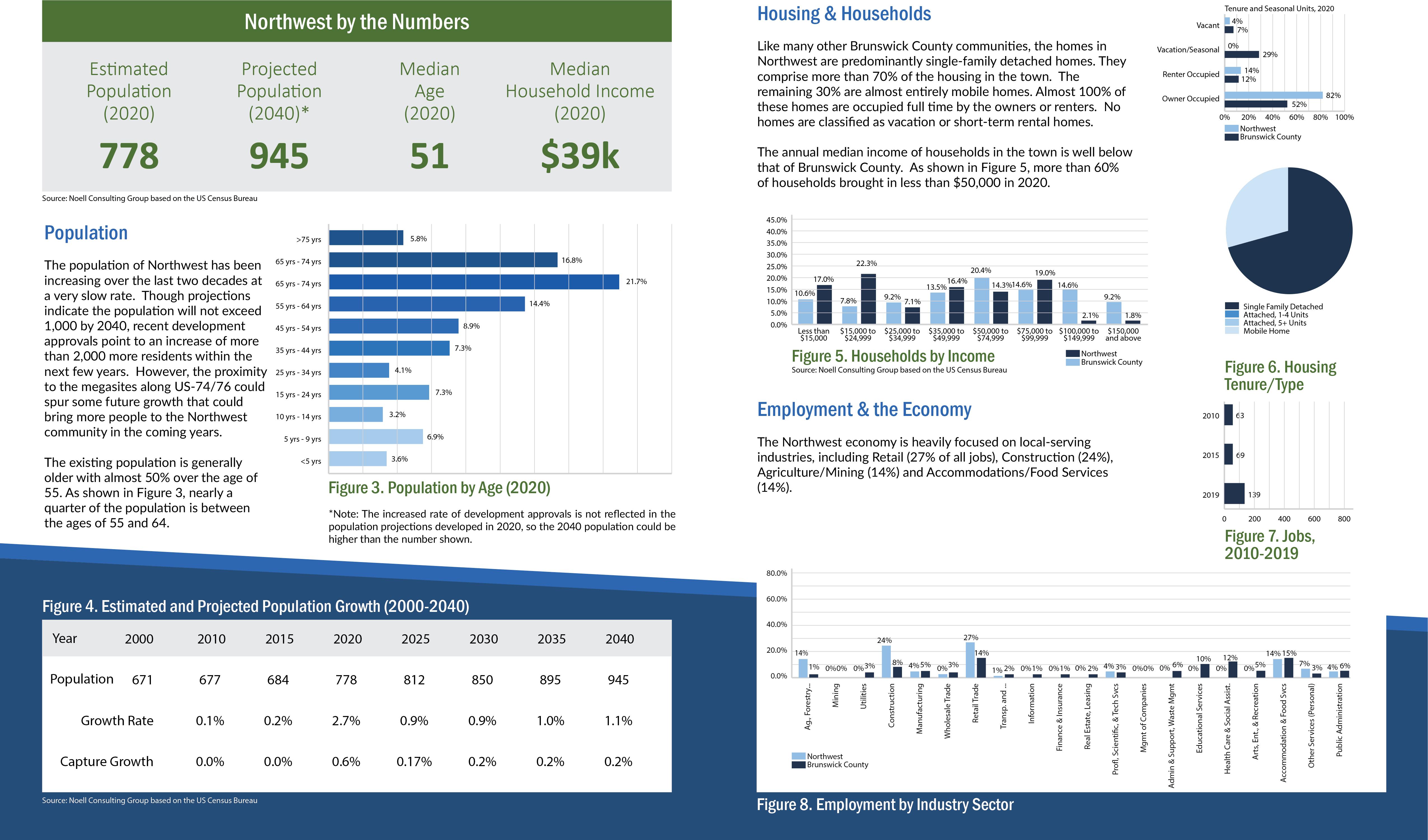
The Town of Northwest was incorporated in 1993. For decades, the railroad town has enjoyed a quiet existence with a rich agricultural history. However, with proximity to the industrial “megasites” along US74/76 and access to I-140, the town is now positioned for development that is in response to demands in the larger Wilmington area for housing, commercial services, and industrial space. This plan conveys ideas for future land use throughout the Town’s jurisdiction. Those ideas are supported by recommendations for policies and strategies for implementation over the next 20 years. The plan was created with thoughtful input of the Town’s elected and appointed officials, staff, and residents who attended the community meetings.
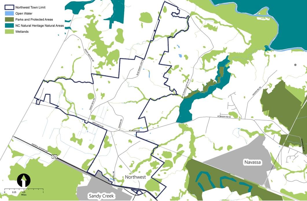
Existing Land Use & Development Pattern
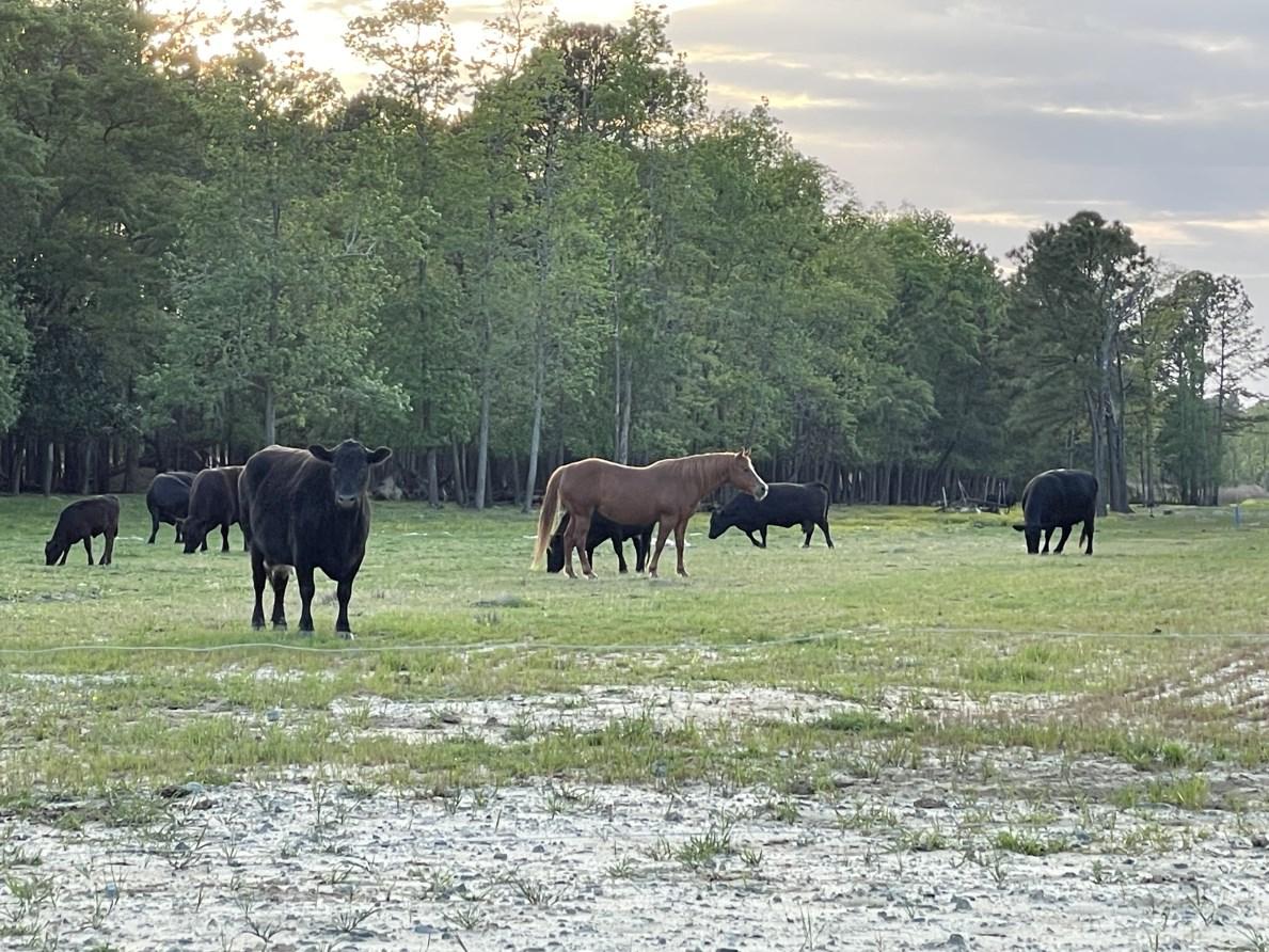
Historically, the town and its surroundings have been part of the larger agricultural community of Brunswick County, and much of the land at the edges remains as working lands primarily for timber production. Over time, development has continued incrementally and at relatively low densities. Single-family homes and large residential lots are located along the few roads that provide a limited amount of circulation around the community. Small-scale light industrial uses are also part of the mix. Several large parcels within the town limits and just beyond are the sites of sizable sand mining operations. Most of the commercial development in the town is oriented toward US-74/76, though some local-serving commercial uses occupy a few parcels internal to the community.
Environment
Few environmental constraints exist within the town limits. Creek corridors and a few wetland areas depicted in Figure 2 contribute to the natural landscape that is the backdrop to the existing development. East and west of the town are areas that have been delineated as by the NC Natural Heritage Program as ecologically important areas valued for the biodiversity within each.
Key Issues & Opportunities
Through the community engagement activities, the residents and other stakeholders shared concerns about future growth, anticipated changes to the development pattern, and potential impacts. While meeting participants and survey respondents identified several issues to be addressed in the coming years, they also highlighted some opportunities to consider as change occurs. The following summary reflects the concerns and ideas expressed.
Economic Development
Citizens recognize that the growth in the region as well as the potential for jobs in the adjacent megasite could spur changes in the community over the next two decades. They view these changes as an opportunity to grow the tax base and create jobs within the town.
Community Involvement
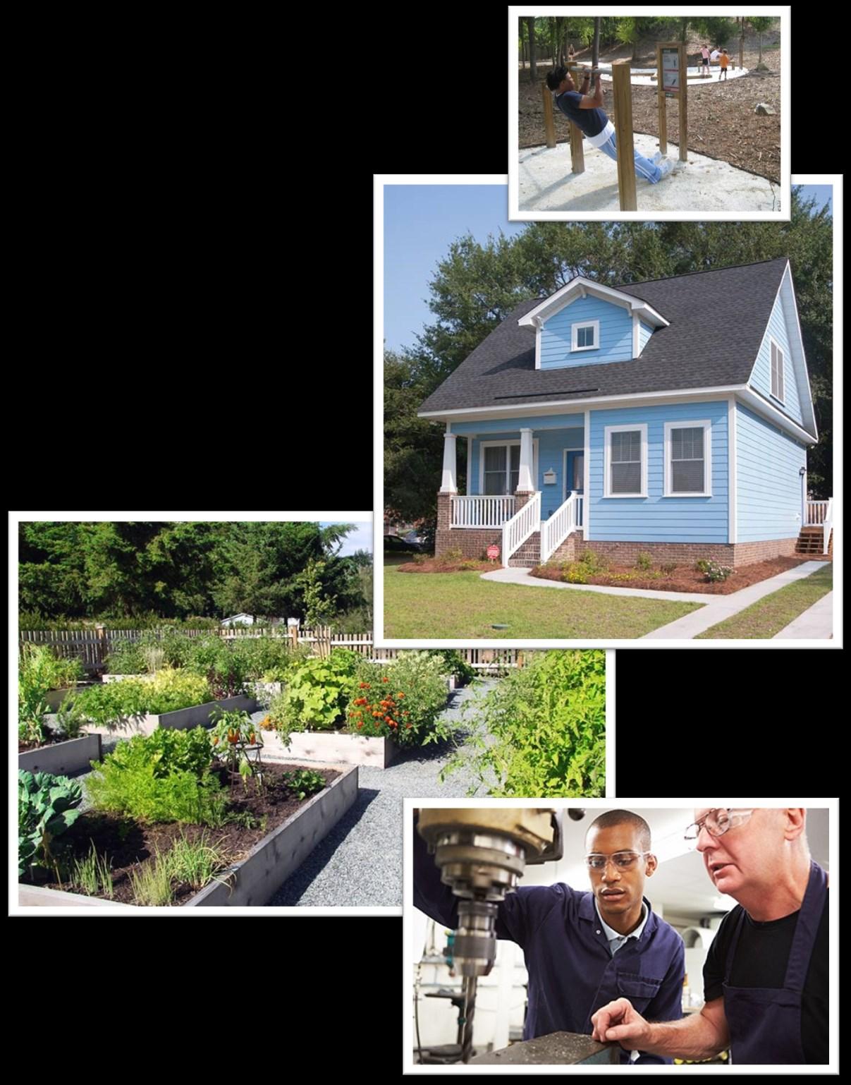
The town is seeking ways to build citizens’ interest in participating in community activities and possible leadership roles. Creating community amenities and other facilities to bring neighbors together is one way the town is planning to foster a sense of community in Northwest.
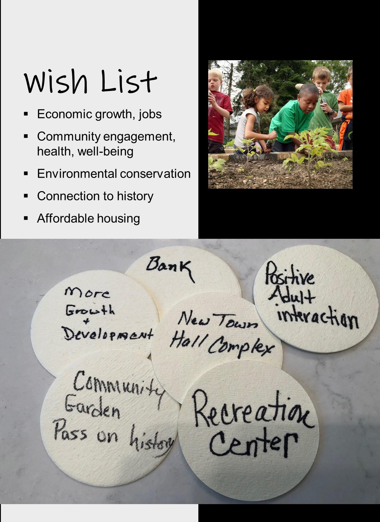
Healthy Living
Social connections, access to healthy food, and recreation that promotes exercise outdoors are among the ideas community leaders are contemplating to ensure the residents of Northwest can have a healthier lifestyle.

Affordable Housing
As the community develops over time, community leaders are supporting the addition of residential development that meets the needs of the future population. Among them is affordable housing. The variety of unit types is already shifting toward smaller products to include apartments.
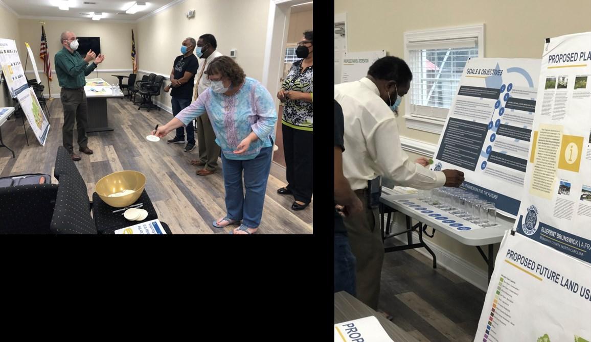
Community Engagement
During the Blueprint Brunswick 2040 planning process, Northwest residents and property owners participated in district level meetings. In addition, community meetings were held in Northwest in March and April of 2022. All such meetings were structured and facilitated to gather input on issues, opportunities and aspirations related to the future development pattern and conservation efforts. Feedback provided through online surveys augmented the input recorded at the in-person meetings.
Top-Ranked Goals
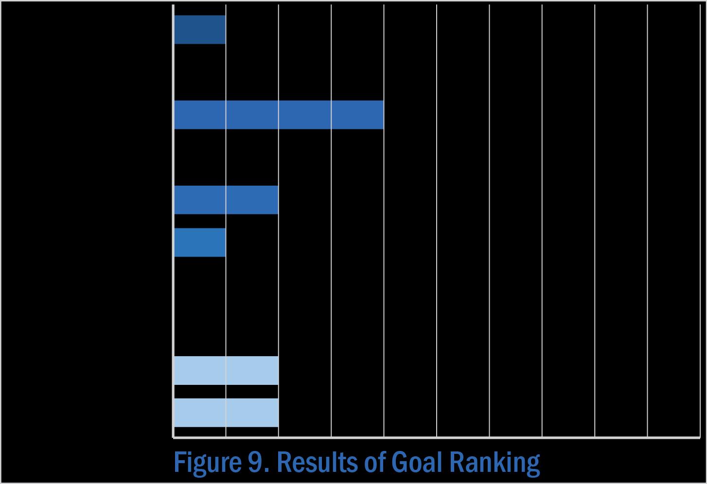
When asked to review the goals for the future of Brunswick County, meeting participants shared their opinions and voted for those they believe are most relevant to Northwest. Meeting attendees agreed the goal pertaining to infrastructure and facilities was the highest priority.
Note: The full set of Goals are presented on page 68-69 in Section 3 of Blueprint Brunswick 2040.
Ideas for Land Use + Precedents
• Mom-n-Pop businesses
• Housing—affordable, senior
• Healthcare, community clinic
• Town hall complex
• Community garden
• Recreation center
• Light industrial
• Bank
• Daycare
Future Land Use
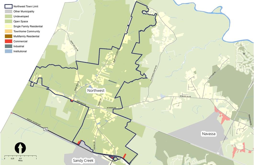
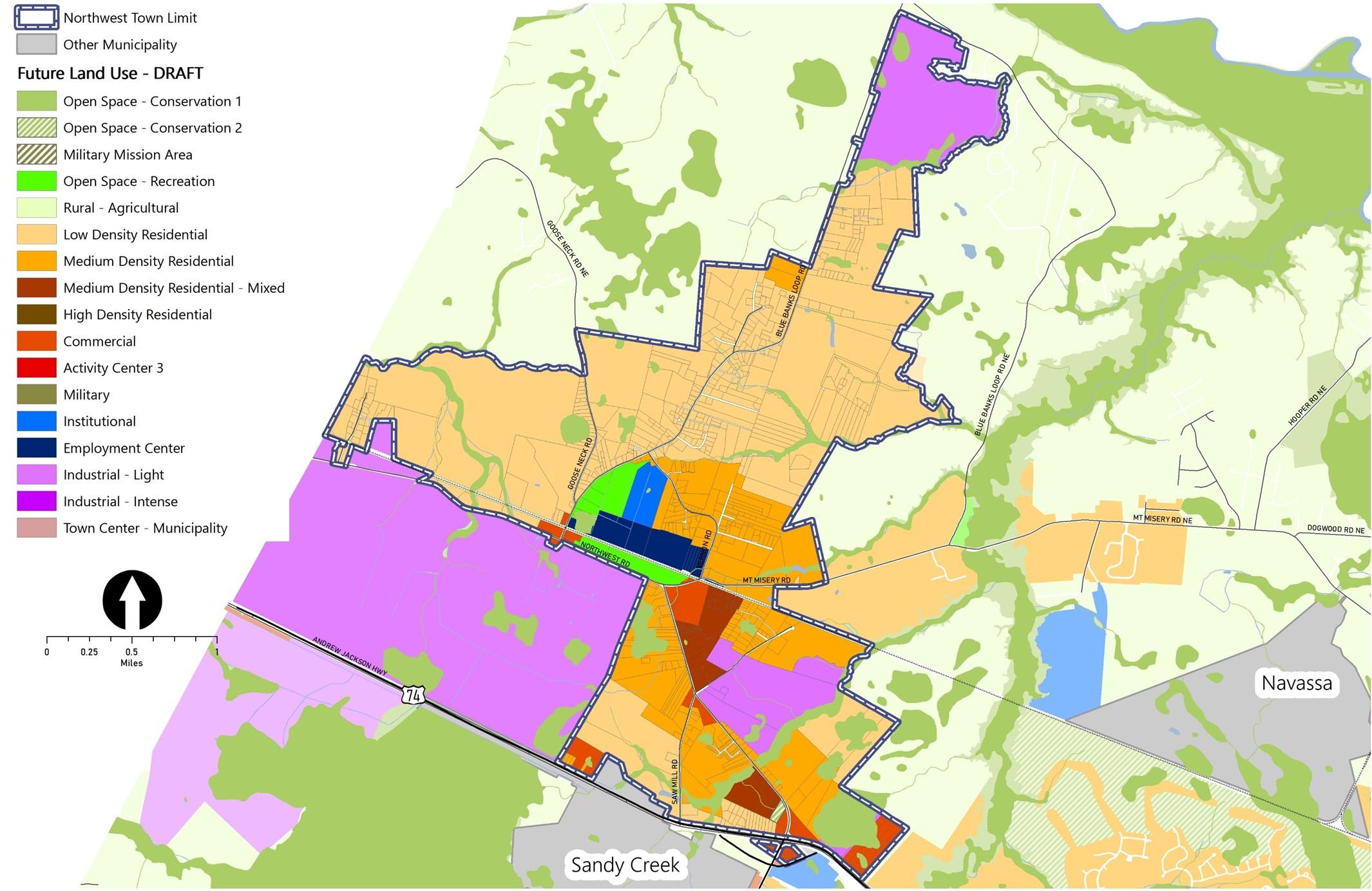
The community’s vision for the future of Northwest indicates support for the creation of a town center where a government complex would be flanked by recreational facilities, community garden space, and some complementary employment uses. Nearby commercial development would be located to also serve the larger daytime population (i.e., people working within and close to Northwest) as well as visitors with access from US-74/76. The plan also accommodates a variety of housing and envisions retention of some of the working lands.
Note: The Place Type descriptions are presented on page 72 in Section 3 of Blueprint Brunswick 2040.
Policy Recommendations & Strategies
The following are a series of policy recommendations and supporting implementation strategies. As indicated in the column on the right, each has a connection to one or more of the recommendations outlined in Section 4 of Blueprint Brunswick 2040.
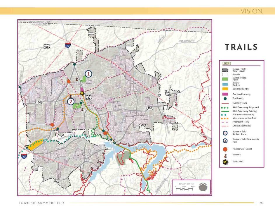
Summerfield Parks, Trails, & Open Space Master Plan: In 2021, the Town of Summerfield, NC hired a consultant to prepare a Parks, Trails, and Open Space Master Plan. The resulting document shows how existing trails can be connected with new facilities to create a linked pedestrian and bicycle network for the community.
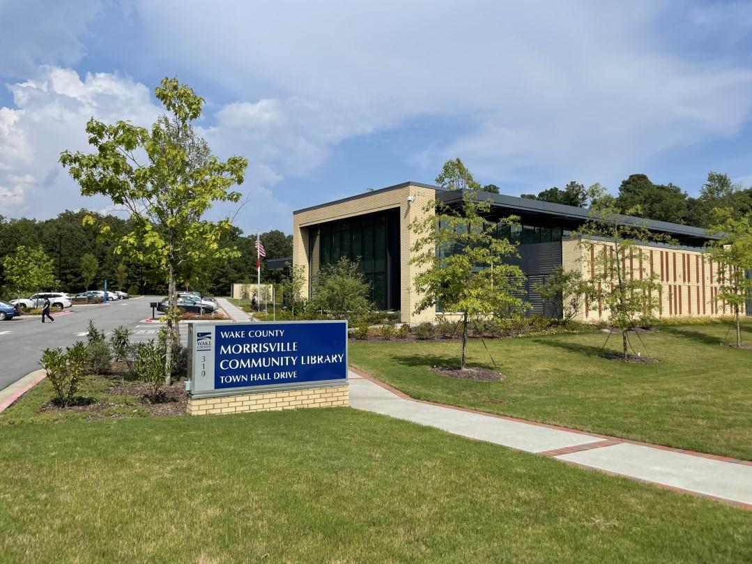
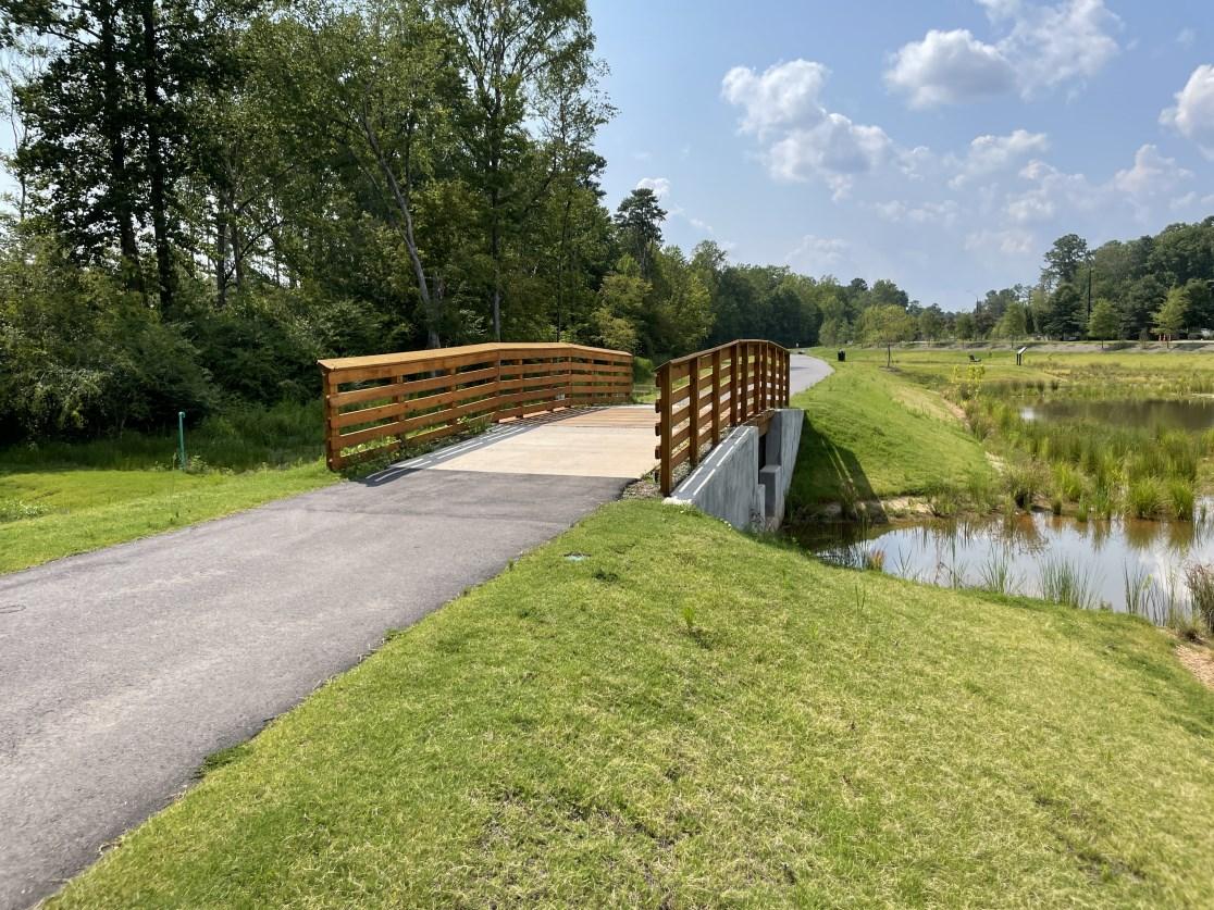
Morrisville Town Center Project: The Town of Morrisville, NC located a trailhead park, a farmers market, a demonstration community garden, and a library in its Town Center to help create a vibrant center of community. These facilities are sited near an intersection in the Town greenway system to help residents access them on foot or by bike. The Town partnered with the Western Wake Farmers Market, the Morrisville Community Garden, and Wake County on different components of the project.
Recommended Action Plan
The Town of Northwest has a long history of small-scale agriculture, semi-rural living, and mutual support, which it would like to preserve, even as its proximity to Wilmington and US 74 brings new growth to the community. The following action steps will help the Town to pursue this vision.
1 2 3
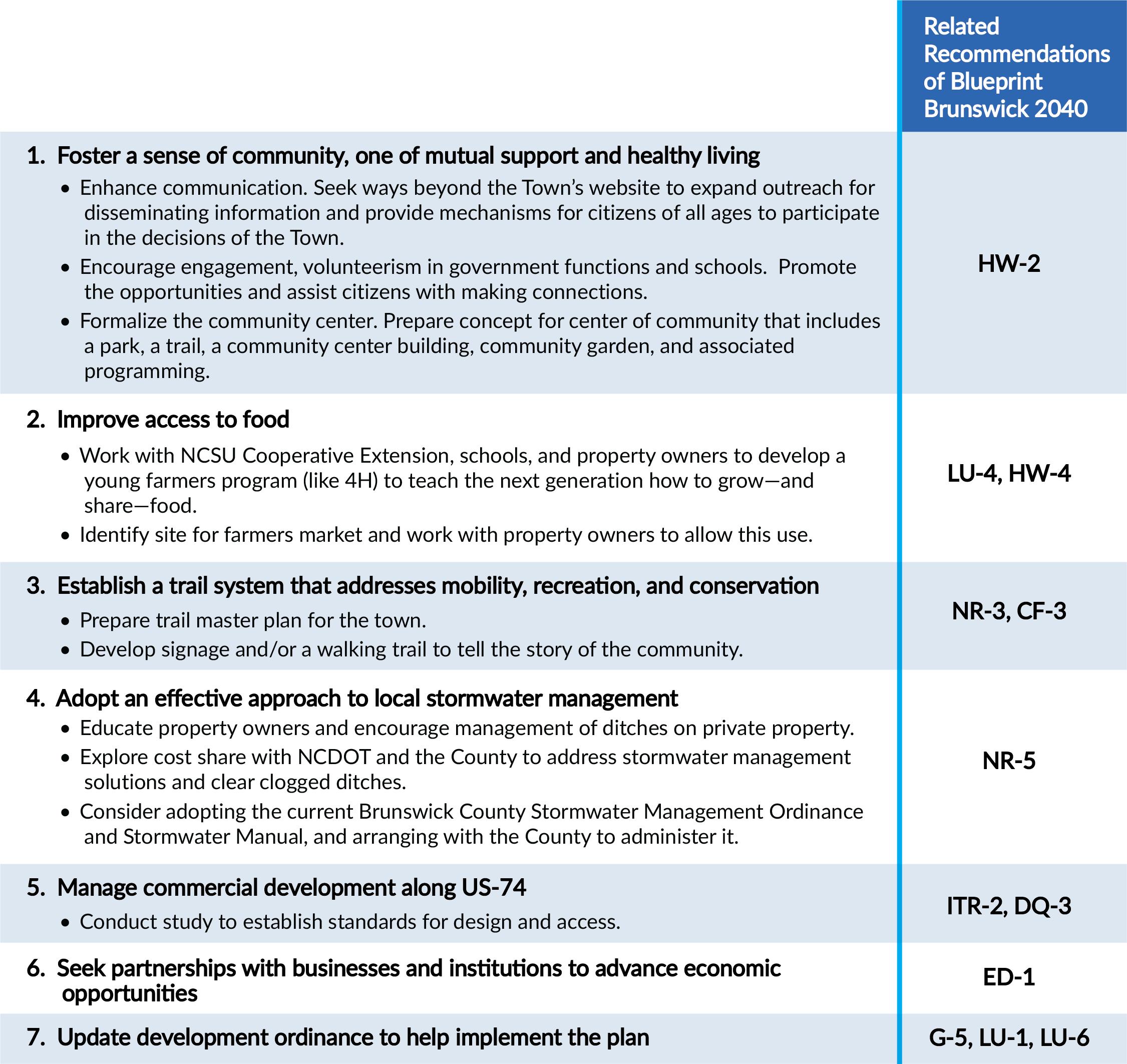
Create a vibrant focal point for community engagement and healthy living. Build upon the existing Town Hall and ballfield to create a dynamic center of community that includes a park, trail, community center building, and community garden, along with programming to engage and connect community residents.
Improve access to locally-grown food. Work with NCSU Cooperative Extension, schools, property owners, and others to develop a young farmers program to teach the next generation how to grow and share food. Identify a site for farmers market and work with local property owners to allow this use.
Develop a community trails system to support mobility, recreation and conservation. Work with the Cape Fear Rural Planning Organization and other partners to hire a consultant to prepare a Trails Master Plan for the community. Develop a walking trail with signage to help tell the story of the community.
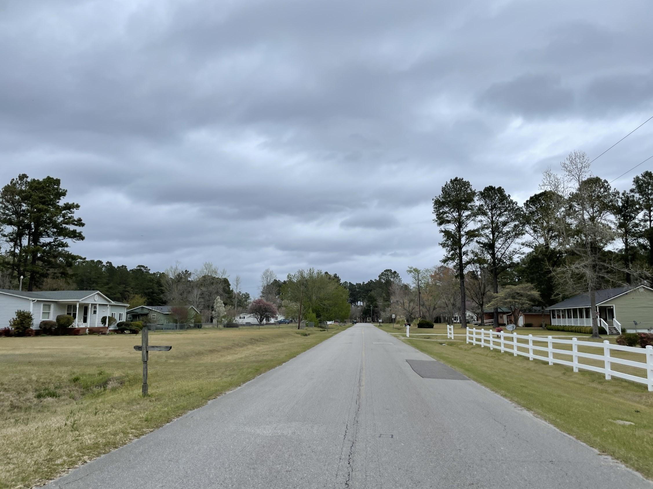
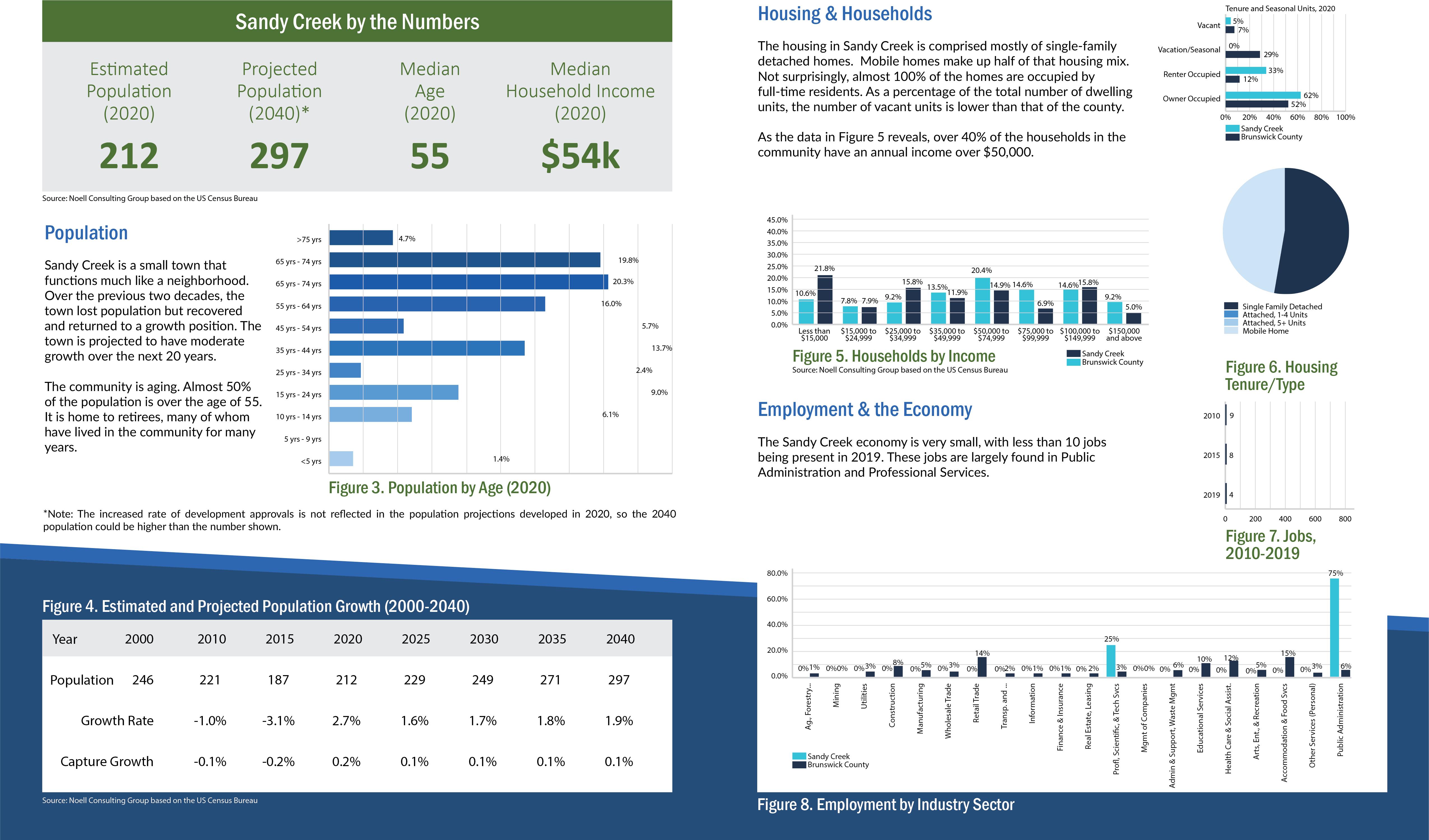
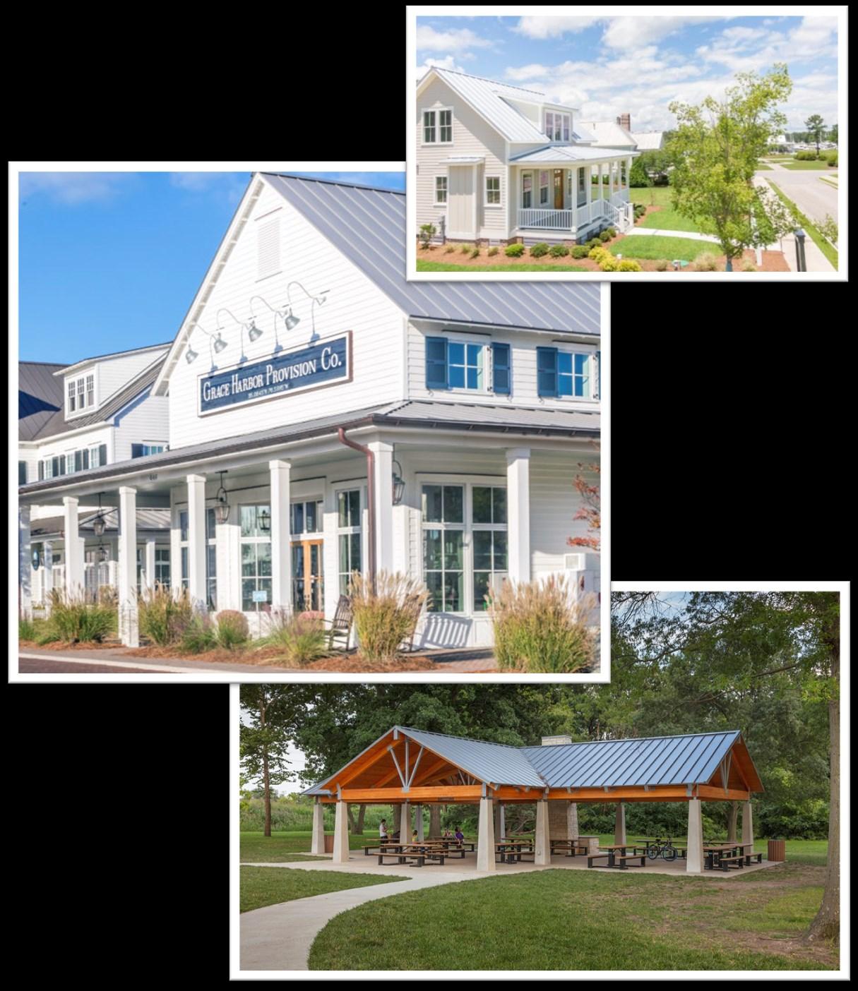
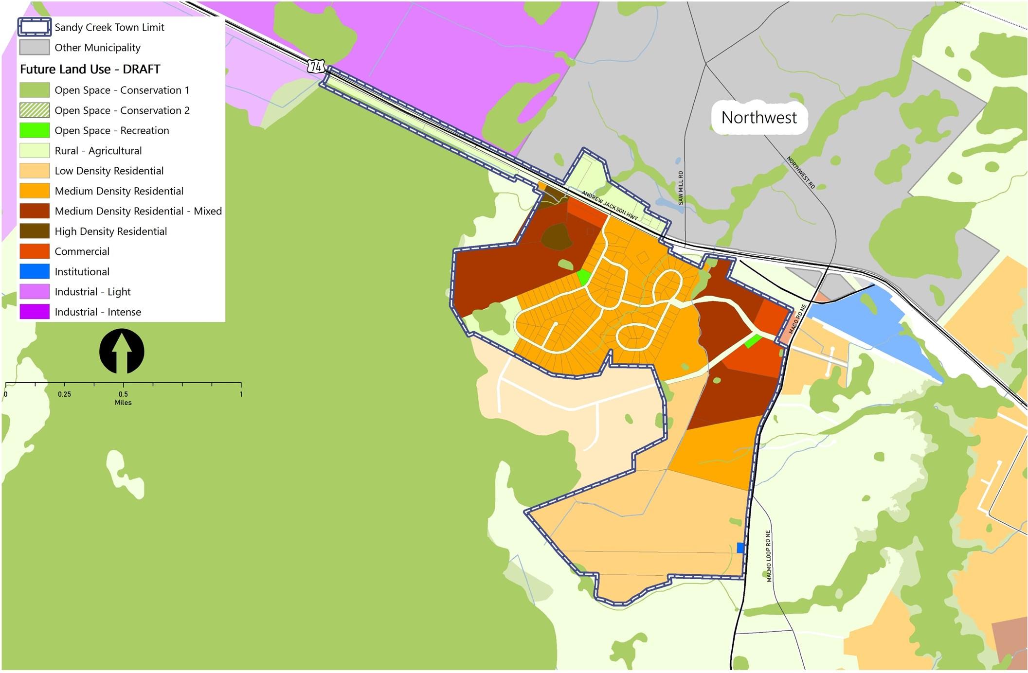
The Town of Sandy Creek began as a private, rural community along US-74. Preserving access was the primary reason the town incorporated in 1988. This plan is a tool for managing change to meet the needs of the existing and future population, introduce uses that will enhance the quality of life in the community while maintaining the “small hometown feeling,” and establish a path forward for sound delivery of infrastructure and services. The plan conveys ideas for future land use throughout the Town’s jurisdiction. Those ideas are supported by recommendations for policies and strategies for implementation over the next 20 years. The plan was created with thoughtful input of the Town’s elected and appointed officials, staff, and residents who attended the community meetings.
Existing Land Use & Development Pattern
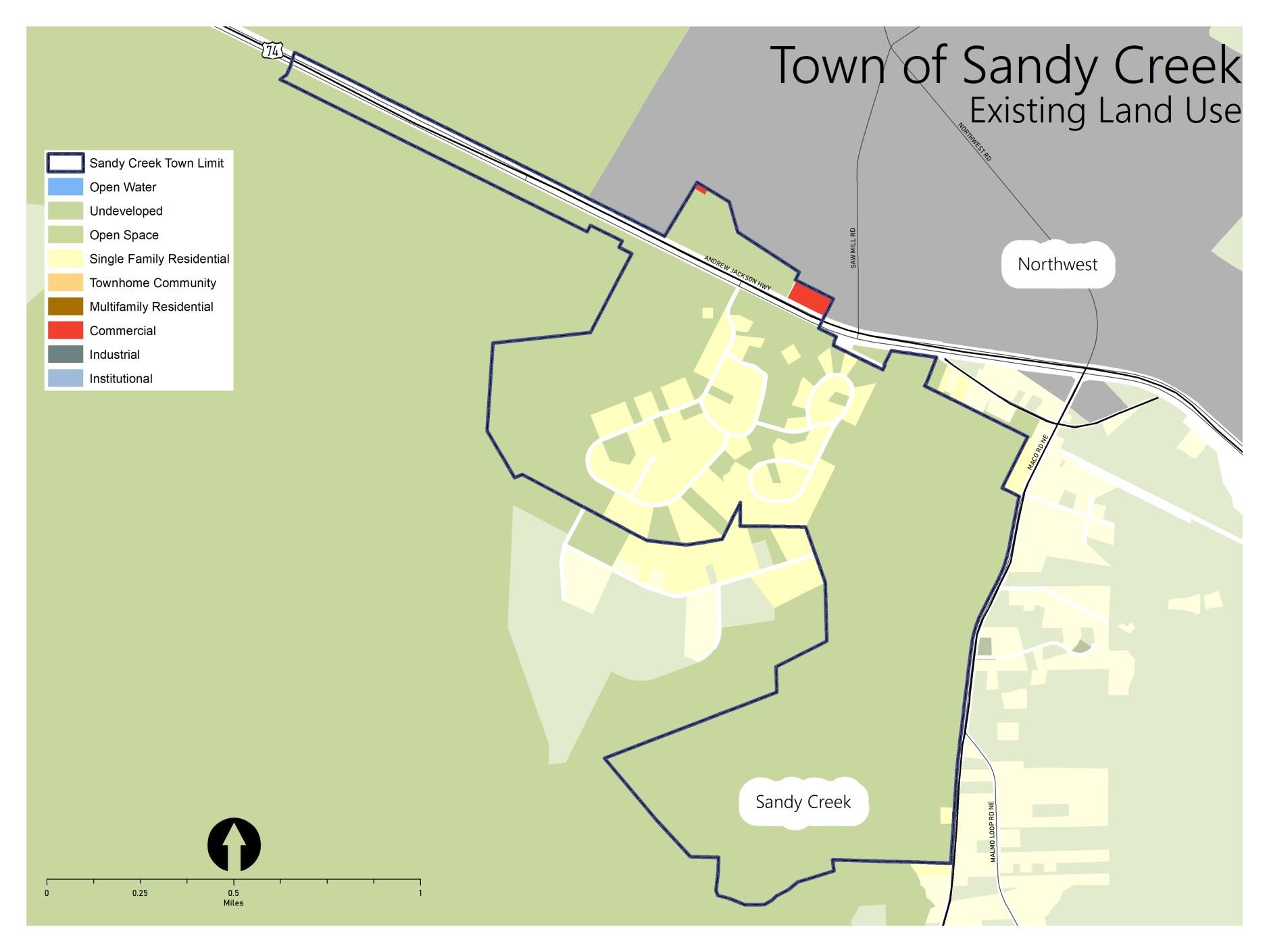
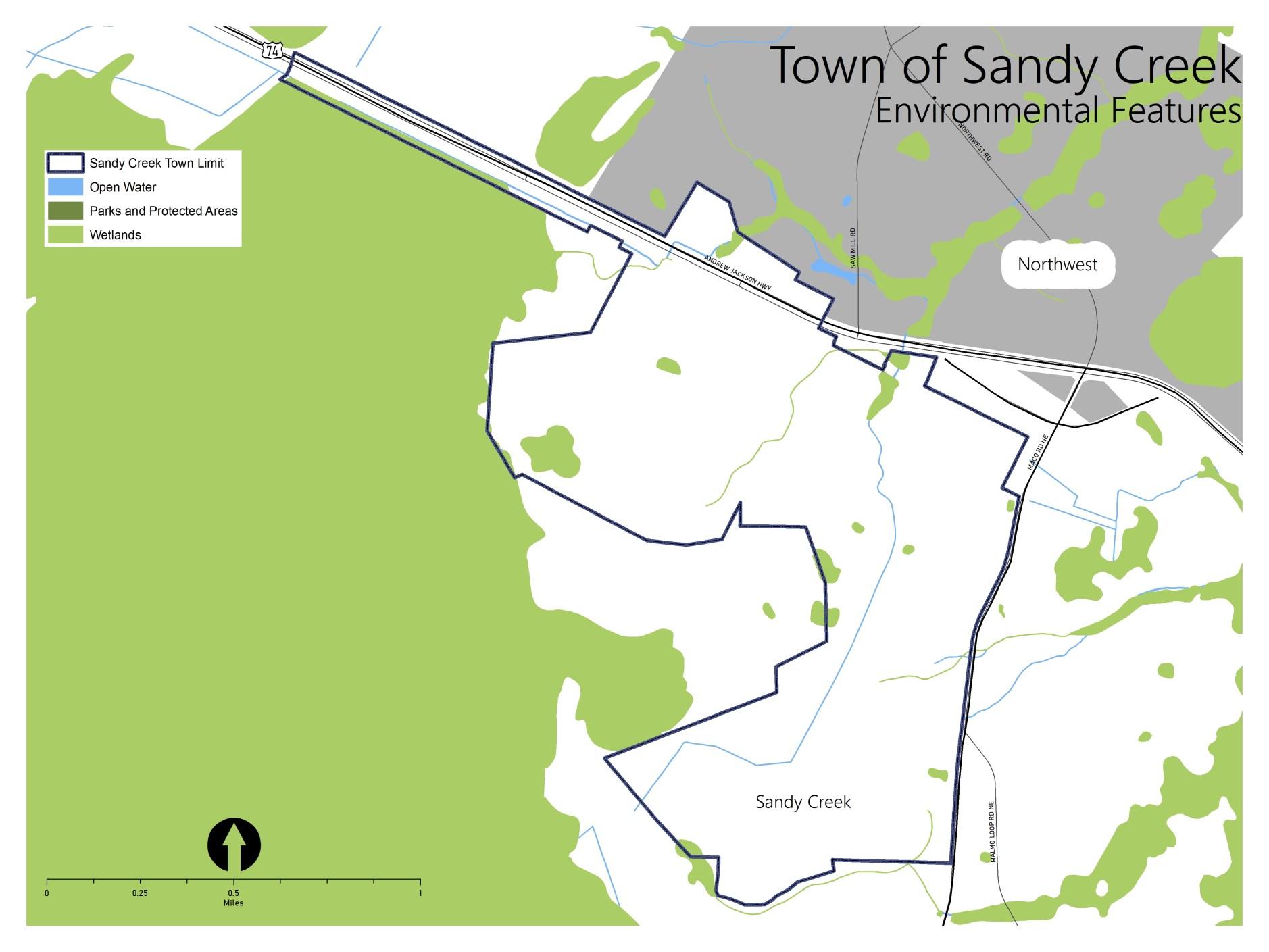
Development in the town is characterized by neighborhoods of large-lot, single-family homes. In fact, the existing lots are each an acre or larger. The few commercial uses are oriented toward US-74 and Maco Rd. NE. Encompassing just 1.3 square miles, most of the area inside the Town limits has remained relatively undeveloped.
Key Issues & Opportunities
Through the community engagement activities, the residents and other stakeholders shared concerns about future growth, anticipated changes to the development pattern, and potential impacts. While meeting participants and survey respondents identified several issues to be addressed in the coming years, they also highlighted some opportunities to consider as change occurs. The following summary reflects the concerns and ideas expressed.
Community Gathering Spaces
In a small town with a limited budget, engagement of residents in leadership, social events, and other community focused activities can be challenging. The citizens that participated in the planning process noted opportunities to utilize undeveloped lots to create public space for gatherings and bring neighbors together.
Access and Circulation
Issues include diminished access for residents and emergency vehicles from the future limitations with the planned conversion of US-74 to a controlled access highway where the town’s sole entrance currently exists; access to new development in town via existing streets; funding to maintain the existing local streets; and safety for pedestrians as there are no sidewalks in the community.
Stormwater
Residents are concerned the flooding caused by obstructions in the ditches and culverts (i.e., litter, debris, etc.) will increase if a more proactive approach to managing these facilities is not employed with adequate funding.
Community Engagement
During the Blueprint Brunswick 2040 planning process, Sandy Creek residents and property owners participated in district level meetings. In addition, community meetings were held in Sandy Creek in March and April of 2022. All such meetings were structured and facilitated to gather input on issues, opportunities and aspirations related to the future development pattern and conservation efforts. Feedback provided through online surveys augmented the input recorded at the in-person meetings.
Top-Ranked Goals
When asked to review the goals for the future of Brunswick County, meeting participants shared their opinions and voted for those they believe are most relevant to Sandy Creek. The goals pertaining to the environment and development quality ranked the highest.
Note: The full set of Goals are presented on page 68-69 in Section 3 of Blueprint Brunswick 2040.
Ideas for Land Use + Precedents
• Essential commercial— café, small-format grocery
• Gathering place
• All single family homes
Future Land Use
The Future Land Use & Conservation Map (Figure 10) reflects a desire to maintain the existing residential area. Consistent with recent approvals, the map also indicates support for new development that offers a broader range of housing types. The vision for future development acknowledges the potential for primary access to shift from US-74 to NC-87 (Maco Rd. NE), which will connect to a planned interchange and redistribute traffic flow. The new entrance would be the place to accommodate small-scale commercial spaces flanked by civic uses (i.e., a new town hall or town green oriented to become a welcoming feature as residents and visitors access the community via a new point of entry).
Note: The Place Type descriptions are presented on page 72 in Section 3 of Blueprint Brunswick 2040.
Policy Recommendations & Strategies
The following are a series of policy recommendations and supporting implementation strategies. As indicated in the column on the right, each has a connection to one or more of the recommendations outlined in Section 4 of Blueprint Brunswick 2040.
Johnston County Conditional Zoning Authorization: In 2021, the Johnston County Board of Commissioners approved a zoning text amendment to authorize the use of conditional zoning to help it work with developers to negotiate site-specific conditions of approval. In so doing, the Board enabled a new tool to help mitigate the impacts of new development and address community needs.
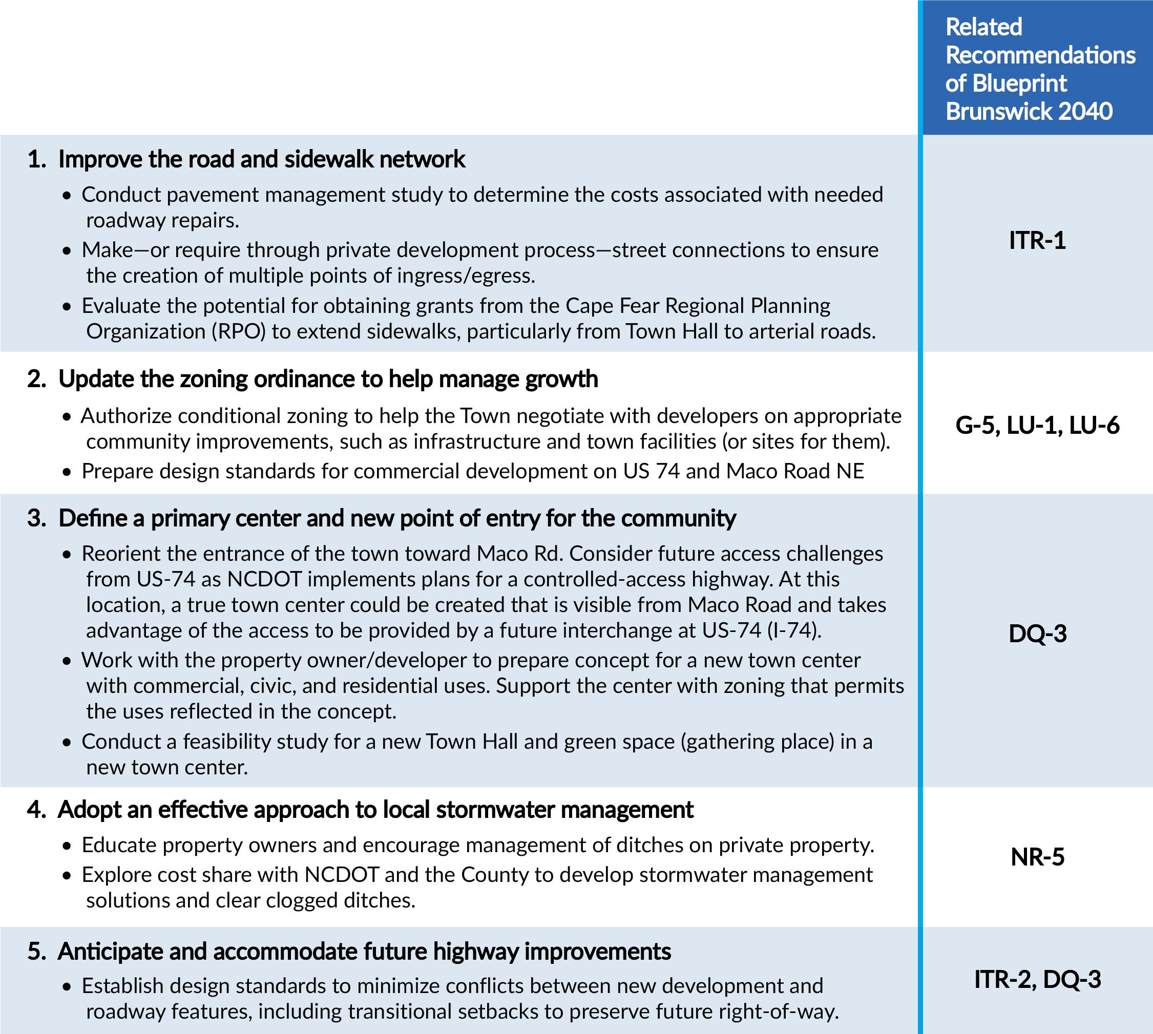
Recommended Action Plan
Apex Pavement Management Study: In 2020, the Town of Apex, NC conducted a pavement management study for Town streets using special software to estimate the cost of pavement improvements and identify which repairs would deliver the greatest benefit for the resources available.
The Town of Sandy Creek is poised for rapid growth, with major road improvements planned on US 74 and new subdivisions and commercial development proposed near existing residences. The Town has a chance to leverage this new investment to help address infrastructure needs and create a dynamic center of community. The following actions will help the Town pursue these opportunities.
1 2 3
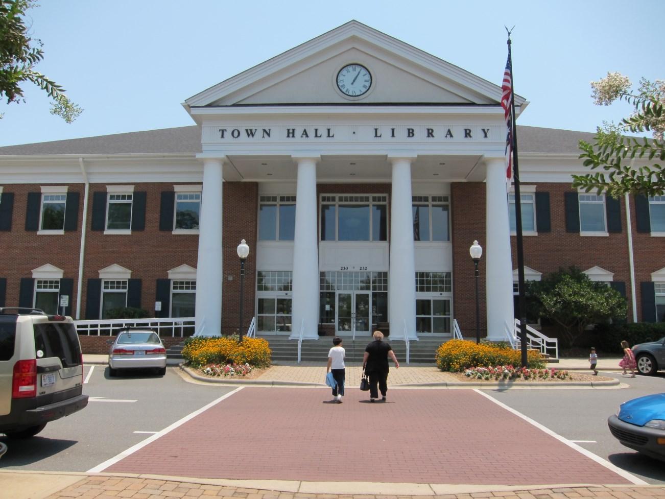
Matthews Main Street Extension: The Town of Matthews, NC worked with a private developer to build a new street with a town hall, library, and shops as part of an extension of its existing commercial district. The result was to create a more dynamic and walkable center of community and add important new public facilities. 4
Improve the road and sidewalk network: Conduct a pavement management study to estimate the cost of needed road repairs. Make or require road connections to ensure a linked network of streets. Work with Cape Fear RPO to explore grants to extend sidewalks to improve pedestrian safety.
Update the zoning ordinance to help manage growth: Authorize conditional zoning to help the Town negotiate with developers on appropriate community improvements, such as infrastructure and town facilities (or sites). Prepare design standards for commercial development on US 74 and Maco Road NE.
Define a primary center and new point of entry for the community. Reorient the entrance of the town toward Maco Road. Consider creating a true town center that is visible from Maco Road and takes advantage of access provided by future interchange at US-74 (I-74). Work with the property owner/ developer to prepare a concept design for a new town center with commercial, civic, and residential uses. Support the center with zoning that permits the uses reflected in the concept. Conduct a feasibility study for a new Town Hall and gathering space in a new town center.
Adopt effective approach to stormwater management: Educate property owners about proper ditch management on private property. Explore cost share with NCDOT and County to develop stormwater management solutions and clear clogged ditches.