REALIZING THE VISION
Comprehensive Plan | Section 4


The policy recommendations presented in this section provide guidance for shaping future growth and development in the county. Along with specific strategies, or action steps, they will aid efforts to achieve the goals and realize the vision reflected in the Future Land Use and Conservation Map. They are in no particular order. (Refer to Section 5 for more about plan implementation and the Action Plan.)
General
County officials should be able to rely on an updated suite of plans, regulations, and data to make sound decisions regarding the future of the County. This plan is one of those tools, and it provides a framework for updates to other plans as well as local ordinances. The following general recommendations focus on using and maintaining the tools necessary for effectively managing growth in Brunswick County over the long term.
G-1. Make consulting Blueprint Brunswick in advance of decision making a regular practice of the County’s elected and appointed officials, County staff, and the County’s strategic partners.
The plan should be the go-to guide on which all County leaders and staff rely for direction as key decisions pertaining to development are contemplated. In conducting the business of the County, leaders and staff should become familiar with the polices set forth in the plan and actively seek ways to ensure all decisions are in agreement with the plan. Ultimately, the plan’s relevance will be measured by its use in everyday decision making.
• Introduce the plan during orientation and consider training sessions at regular intervals to periodically reintroduce the plan. County leaders and staff are subject to at least one orientation as they accept their positions and associated responsibilities. This is an opportune time to familiarize the board members’ and employees with the contents of the plan and the intended uses. However, over time, the information conveyed may be forgotten. Sessions held annually or semi-annually provide individuals an opportunity for a “refresher” and a chance to ask questions to clarify the appropriate application of the plan in decision making.
• Require County officials and staff to reference the plan in providing a rationale for positions taken in conjunction with key decisions. The recommended policies in this section are numbered so individuals can refer to one or more in stating for the record a justification for each decision.
• Share the plan with affected jurisdictions, organizations, and agencies. Municipalities, neighboring counties, local nonprofits, regional planning organizations, Brunswick County Board of Realtors, Business Alliance for a Sound Economy (BASE), and State agencies (i.e., NCDOT, NCDNR, NCDWQ) are among the many entities that may be impacted by the implementation of the County’s plan. (Refer to GC-1.)
• Promote the plan to potential investors. Whether investigating Brunswick County as a place to grow a business or develop property for commercial or residential uses, private investors can make informed decisions about locations and level of investment to consider. At the most basic level, the plan is a communication tool, sharing the community’s expectations and aspirations for the future of the county. As such, the plan can influence private sector decisions. By communicating opportunities and expectations, the plan can facilitate alignment between private investments and public policy. Clear communication can help streamline the development approval process.
G-2. Maintain the relevance of Blueprint Brunswick.
Blueprint Brunswick is a policy guide. Anticipating the growth in the county over the next two decades, it is intended to establish the community’s long-term vision for the future development pattern and provide direction to achieve the vision. Over time, circumstances will change. To ensure the plan remains relevant and useful, the County will need to follow steps to assess and update the plan.
• Every five years, or more frequently, review the plan to determine whether circumstances of the county have changed significantly, warranting adjustments to the specific policies and/or the Future Land Use and Conservation Map. Note: Substantial changes would warrant recertification by the Division of Coastal Management.
G-3. Implement Blueprint Brunswick through a structured implementation process.
Planning is the first step in a process to better manage growth in the county. The resulting plan sets the County officials up for a series of actions and initiatives to be undertaken over a period of several years. The early steps, which include organization, are crucial, as effective plan implementation must be done through a well-thought-out process. To begin efforts to realize the vision documented in the plan, the following initial steps should be considered. (See Section 5 for more about plan implementation.)
• Develop an action plan.
• Based on the action plan, assign responsibilities to the appropriate parties, which will include County departments as well as partner agencies, and establish milestone deadlines for specific actions.
• Maintain accountability.
• Report progress on a regular basis. This may be quarterly but not less than annually.
• Form an implementation committee, if needed, to meet regularly, review progress, and determine the need for a course correction (i.e., reprioritization of action items to address new or emerging circumstances and opportunities).
G-4. Use the plan to guide decisions regarding public investments.
The plan and the policies within provide guidance on directing growth to specific areas of the county as well as guidance on investments in these areas to ensure future development is drawn to these locations. The delivery of infrastructure and services or the commitment to provide them to support the desired development (and redevelopment) can reinforce the Vision while providing a powerful incentive for investors to develop properties in accordance with the Vision. As a result, use the plan to help when updating County utility policies, planned service areas, and water and wastewater system master plans.
15A NCAC 07B .0804 Required Periodic Implementation Status Reports
Jurisdictions with a locally adopted and certified land use plan shall submit an Implementation Status Report to the Division of Coastal Management every two years from the date of initial certification by the CRC. This report shall be based on implementation actions that meet the CRC’s Management Topic goals and objectives, as indicated in the action plan pursuant to Rule 07B .0702(e)(3) of this Section. The Implementation Status Report shall also identify: (1) All local, state, federal, and joint actions that have been undertaken successfully to implement its certified land use plan; (2) Any actions that have been delayed and the reasons for the delays; (3) Any unforeseen land use issues that have arisen since certification of the land use plan; and (4) Consistency of existing land use and development ordinances with current land use plan policies.
G-5. Amend, or rewrite, the Brunswick County Unified Development Ordinance (UDO) to effectively implement the plan with local regulations that align with the policy recommendations.
The County’s UDO contains the regulations associated with land development, including zoning and subdivision standards. It was revised and readopted in 2015 and has been amended several times over the last several years. The number of amendments is an indication the UDO has become less relevant and is no longer serving as an effective tool for managing change in a fast-growing county.
The recommended policies contained herein are intended to achieve the community’s vision for the future of Brunswick County. While many strategies for achieving that vision are presented in connection with those policies, the local regulations are perhaps the strongest mechanisms the County can employ to achieve the desired land use pattern while conserving the many assets the community values. Some necessary adjustments to the code may be accomplished as simple amendments in the near term while others should be addressed as part of a more involved effort to produce a new, modernized UDO.
• Evaluate the UDO to determine the need for significant changes or a full replacement.
• Based on the results of the evaluation, proceed with minor amendments to address immediate needs. This will help alleviate “growing pains” and expedite the County’s efforts to facilitate desired development, particularly those needed in advance of or while pursuing the creation of a new UDO.
• If the evaluation reveals the need for a new UDO, initiate a process to prepare an updated UDO, and move forward with a more detailed assessment of the current regulations, examining them through the Blueprint Brunswick lens. Then, using the assessment as a guide, begin code drafting. The final, adopted UDO may be followed by an update to the Official Zoning Map of Brunswick County to redesignate parcels with the updated set of zoning districts.
• Improve predictability of approvals with a streamlined process.
Evaluate current review and approval procedures for rezonings, subdivisions, and site plans to determine opportunities for expediting steps in each process. Consider administrative approvals for plans that meet specific criteria.
G-6. Update other adopted plans.
Several other plans have been adopted in recent years, including the Brunswick County Trail Plan, the Agricultural Development Plan, and the 2021 Regional Hazard Mitigation Plan. The recommendations of such plans have been taken into consideration and the relevant policies in those plans helped formulate the recommendations outlined in this section. Going forward, current plans should be reviewed to determine the need for updates to ensure consistency with the recommendations of Blueprint Brunswick 2040, which now serves as a new framework for growth management in the unincorporated areas of the county as well as a few participating municipalities.
G-7. Develop and adopt new plans.
The comprehensive plan sheds light on a number of issues, including some emerging trends, that will need to be addressed through supplemental planning efforts. Specific plans provide an opportunity to examine and provide solutions for issues at a deeper level than a comprehensive planning effort affords. Small area, corridor, and facility plans are three examples. All such supplemental plans should build on the policies of the comprehensive plan and be prepared as companion documents that complement Blueprint Brunswick. Together, all adopted plans should work in concert to provide a suite of guidance documents. (Refer to the other subsections of this Section 4 for more information about additional plan recommendations.)
G-8. Raise awareness of Blueprint Brunswick and celebrate implementation milestones.
In rapidly growing communities, it is common for the citizens to be concerned about the direction of growth and how leaders are addressing growth-related issues. “What is the County doing about it?” is a question frequently asked by citizens as they witness change around them. Knowing the County has a plan as well as strategies for implementing it is crucial in building confidence among the citizenry and garnering support.
The comprehensive plan is for the entire community. While County officials and staff will utilize the plan on a regular basis to make informed decisions, citizens and other stakeholders should be familiar with the plan and how it serves to bring about change the community desires. Following plan adoption, the County should be deliberate in raising awareness of Blueprint Brunswick, helping citizens understand the value of the plan, drawing attention to the goals it aims to achieve, and celebrating each successful step completed on the path toward realizing the community’s vision for the future.
Consider the following ways to help citizens take ownership of and appreciate Blueprint Brunswick.
• Create a marketing campaign to roll out the new plan. Using informational materials (print and online), let citizens and other stakeholders know about the plan, its purpose, and its content.
• Measure progress publicly. Celebrating each milestone reached is an effective way to remind the community of the plan’s existence and the County officials’ commitment to implementation.
Connect with print and online media outlets to enhance communication efforts.
Continue to utilize social media to share positive results.
Consider public events to mark major achievements.
• Clearly communicate connections to previous efforts. It may be important to make the point that the development and implementation of Blueprint Brunswick is not a new practice of the County and that the actions of the County will build on earlier initiatives.
Use the roll out and milestone celebrations as opportunities to share information about the County’s history of planning and growth management and to communicate recent successes and ongoing initiatives. As residents and property owners learn more about the cumulative effects of proactive measures over several decades, they may develop a greater appreciation for the County’s efforts over many years.
Land Use Compatibility & Growth Management
Future land use is the emphasis of any comprehensive plan, as the potential future development pattern affects many aspects of decision making in local government. Guiding growth in a manner that is consistent with and will help realize the desired future pattern of development requires an understanding of that pattern as well as the implications for future infrastructure and services to support it. Featured in the “vision” are the assets within the county to be conserved. They, too, are part of the future pattern. County leaders can intentionally help ensure the conservation and sensitive integration of such features as development continues to shape the county. The recommendations that follow address the details of the corresponding Future Land Use and Conservation Map presented as the “Vision” in Section 3.
Brunswick County and its participating municipalities will direct growth in a manner that ensures activities associated with the development or preservation of land are consistent with the suitabilityof the land.
LAND USE COMPATIBILITY & GROWTH MANAGEMENT GOAL:
LU-1. Recognize the County’s position in its evolution and how to leverage that position for positive change. All communities change over time, and the rate of change within each can vary across decades. In periods of high growth, changes can occur so rapidly that market conditions shift before community leaders realize what is happening. After years of supporting a broad array of private investments and welcoming any change as a positive step toward economic stability or growth, it can be difficult, even uncomfortable, for those leaders to scrutinize development proposals and say “no” to those that do not advance the community toward its goals. Brunswick County has evolved beyond the point of needing to accept all forms of economic growth. The County has transitioned to a position that allows leaders to be more discerning in their appraisals of opportunities.
• Educate decision makers. Use the roll out of the new plan as an opportunity to help key decision makers understand the leverage the County now has due to changing market conditions and be more selective. Encourage County officials and staff to examine opportunities through the new lens provided by the plan. With an understanding of the leverage the County has, County leaders and staff should
Support amendments to local land development regulations that raise the standards for future development and redevelopment. Regulatory tolerances go up as market demand for real estate increases. (Note: This may require increases in staff capacity to maintain review schedule.)
Support only those changes in the development pattern that align with the vision.
LU-2. Support development in areas that are best suited for future development.
• Direct future growth toward existing communities where existing and planned infrastructure capacity as well as services can support additional growth. As the centers of commerce in the county and the areas of population concentrations, the existing communities are the logical places for the delivery of services and infrastructure, particularly as they expand over time.
• Direct higher development to unincorporated areas of the county that are designated as commercial and mixed-use activity centers on the Future Land Use and Conservation Map. Encourage growth in areas that are or will be served with infrastructure and services.
• Support the municipalities as they grow and change over time to accommodate new residents, jobs, and activities, and reduce pressure for development in the unincorporated areas of the county.
LU-3. Support the concentration of future development in nodes in unincorporated County areas to ensure more efficient infrastructure provision and service delivery.
Growth in Brunswick County is increasing development at a rate and density that is rapidly consuming land and placing undue burdens on county systems. Directing the same development to a few key areas at higher densities helps reach a critical mass that justifies the provision of services (e.g., transit) and allows for a more resource-efficient approach to the delivery of infrastructure capacity and facilities (e.g., health services).
• Consider facilitating the creation of mixed-use communities in areas identified as “AC 1, Community Centers” on the Future Land Use and Conservation Map.
In connection with a new District Park or Community Park, develop Community Centers (AC 1) in key locations that have the following: senior center/rec center, community green (programmable), retail, restaurants, office, medical office, healthcare services, drugstore, grocery/market, school(s), senior living (assisted, independent, condos and other empty-nester preferences).
Leverage County-owned land and existing or planned facility locations, particularly where existing or planned infrastructure capacity can be utilized. Land owned and maintained by the County coupled with infrastructure to support more intense development offers the leverage the County needs to attract future development to key nodes and create civic anchors (i.e., schools, libraries, parks, community centers, and other public venues) facilitate other anchors (e.g., medical facilities, museums, and entertainment and recreation destinations), that can catalyze development envisioned for the nodes.
• Consider creating area plans for the areas designated as AC 1 to better inform decisions regarding the utilization of County assets to entice private investment.
• Based on the proposed development programs in the area plans, prepare Requests for Proposals (RFPs) to send to developers in seeking partners to utilize County-owned land within designated centers.
Establish these locations as hubs where access to various transportation modes can enhance mobility.
• Link to transit:
Local and Regional Transit –Stops for Brunswick Transit System (BTS), as well as park-n-ride for regional transit service to Wilmington and Myrtle Beach.
Micro-transit service as an alternative to fixed-route buses, shuttles, and vans, micro-transit utilizes ride-sharing technology. Routes, stops, and schedules are dictated by rider demand and are always shifting. Compact, walkable development can make this option more feasible for riders and drivers.
• Link to the regional trail system (segments of the East Coast Greenway and the Gullah Geechee Heritage Trail) via pedestrian and bike path connections.
Carefully crafted land development regulations can facilitate mixed-use development in unincorporated areas of the County. The Briar Chapel development in Chatham County was accomplished with the “Compact Communities Ordinance.

• Encourage other organized centers in places such as those identified as “AC 2, Neighborhood Centers” and “AC 3, Crossroads” on the Future Land Use and Conservation Map. Selected locations should serve existing and emerging population centers, and the form should be compact to minimize sprawl in unincorporated areas.
• Consider establishing location criteria by which new nodes might be evaluated, particularly as applications for proposed development that adheres to the place type descriptions are submitted.
• Based on the description of each place type, establish new zoning districts that enable mixed-use development at varying scales and set forth design standards for development form, connectivity, and open space amenities. (Refer to LU-6)
Consider the principles of compact, walkable communities and define design guidelines that can be codified for each type of center.
As needed, consider developing a small area plan and an associated form-based code for key nodes, such as those experiencing significant growth pressures.
Evaluate whether to establish limits on the amount of commercial development allowed in unincorporated county areas. If such limits are set, determine the criteria for adjusting such limits, including available infrastructure capacity and increased market demand as verified through a market study.
• Discourage “strip” commercial development, particularly that which adds local vehicular trips to major arterials and exacerbates increasing traffic congestion.

Conduct corridor studies as need to
• Establish policies regarding appropriate locations for commercial development nodes along major arterial roads and use standards to effectively discourage development between nodes.
• Establish land development regulations to implement the corridor plan recommendations. (Refer to ITR-2 for more about corridor studies.)
Development Standards that Influence Commercial Location Choices:
• Minimum site area and parcel depth;
• Building setbacks;
• Vehicular access, including secondary access points from local and collector roads, and shared access drives;
• Connectivity across adjacent commercial development sites through cross-access easements; and
• Streetscape improvements and landscape buffers.
Applied to specific areas, development standards can attract commercial development to key nodes and discourage it between those nodes.

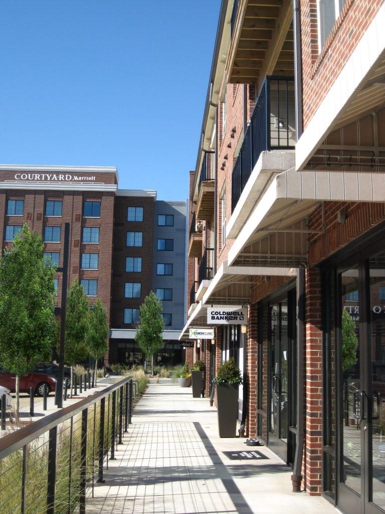
Characteristics of Compact, Walkable Centers

Compact, walkable centers are deliberately designed to efficiently utilize available land within a small area. Some of the characteristics common to many successful centers include the following:

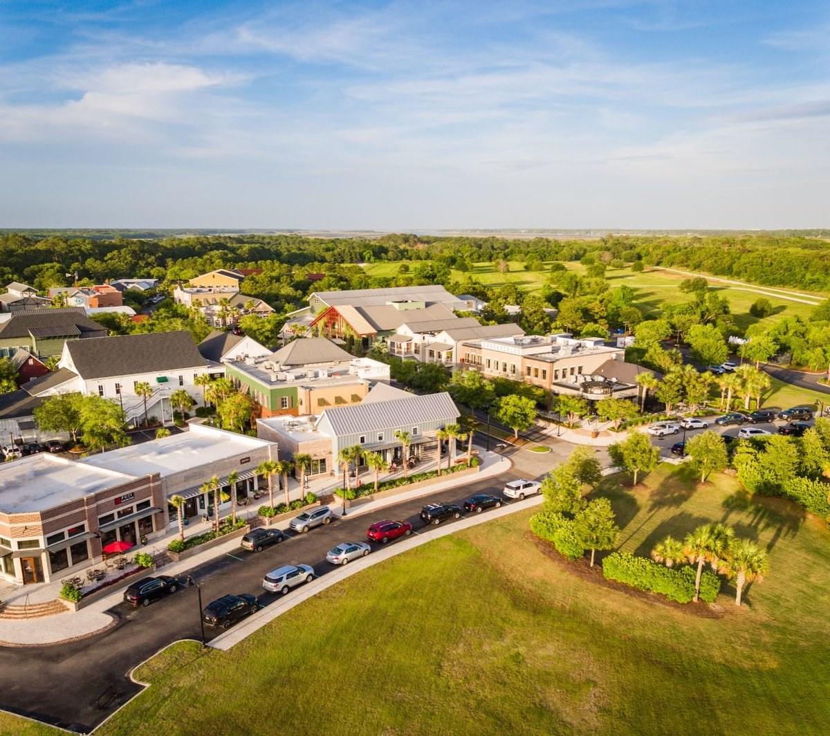

Proximity of Uses – The range of residential and non-residential uses are located within a 10-minute walk distance (1/4-mile radius measured from a center point).
Density – A compact form of development is achieved with multi-story buildings that house residential and/or non-residential uses.
Multi-purpose Public Spaces – Streets, parks, plazas, courtyards, greens, and other publicly-accessible spaces are designed for people to gather, rest, and enjoy being outdoors. Art, water features, landscaping, and seating are among the furnishings enhance comfort and expand the utility of the outdoor spaces as extensions of indoor spaces. Even parking lots can be used as temporary seating/ dining areas and vendor spaces (think: weekly farmers markets).
Complete Streets Streets are designed to support vehicular, pedestrian, bicycle, transit, and other modes, providing convenient access to buildings that are situated close to and oriented toward the streets.
LU-4. Conserve viable agriculture while facilitating the transition of some existing working lands affected by urbanization.
Some, not all, of the land currently in use for agriculture, which includes farms with crops and livestock as well as lands managed for forestry/silviculture, will continue to contribute to the local economy for the foreseeable future. However, the viability of many of the existing operations over the long term depends on several factors related to the physical attributes of the development pattern, including distance from encroaching development, access to the road network for maneuvering farm equipment (i.e., tractors), and contiguity of areas suitable for agriculture. Agriculture is more viable in areas where there is a sufficient amount of land area uninterrupted by other development.
• Conserve and expand agriculture.
Identify areas of viable agriculture (which may include Voluntary Agricultural Districts; Present Use Value program participants; and areas of Productivity, Versatility, and Resiliency, or “PVR”).
• Implement the recommendations of the 2019 Agricultural Development Plan. Consider an enhanced set of tools to ensure the long-term viability of agriculture, including:
• Education about and assistance with conservation easements and family trusts.
• Voluntary Agricultural Districts (VADs), as promotion could help expand these in key areas.
• Buffers - Provided by the developing use (i.e., a new neighborhood), the buffer requirements could be based on a sliding scale with factors, such as the level of protection in place on the existing farm, dictating the width and amount of vegetation to preserve or plant.
• Transitional zones in which a limited set of allowable uses would improve compatibility between residential uses and farming activities.
• Agribusiness Ordinance or District - Consider a zoning district specifically intended for agricultural uses, as the Rural Residential (RR) district may be too broad for the preservation agriculture and may promote urban sprawl instead of conserving the rural character of these unincorporated areas of the county. This may be a base district or an overlay district. The application of the district should align with areas of viable agriculture. Rezoning land to the district should be voluntary and may be incentivized through an expanded set of permitted uses (farm support uses and non-farm uses) as well as eligibility to participate in County programs established to help farmers maintain agricultural operations.
• Purchase of Development Rights, a program that the County could establish and offer to owners of qualifying farmland.
Productivity, Versatility, and Resiliency (or “PVR”)
“The PVR index is the first-ever assessment of agricultural land quality that explicitly accounts for productivity, versatility, and resiliency. Higher PVR values indicate higher suitability for long-term, intensive crop production, especially for food crops such as fruits, nuts, vegetables, and staple grains.” (Source: Farms Under Threat: State of the States project, version 2.0, Conservation Science Partners and American Farmland Trust, 2016.)
Raise awareness of and promote agricultural conservation easements.
• Work with NCSU Cooperative Extension Services (Brunswick County Center) to increase education about conservation easements and the benefits.
• Provide technical assistance to owners of agricultural land in establishing easements.

Work with area farmers and NCSU Cooperative Extension Services (Brunswick County Center) to promote the industry through:
• Agritourism
• Local foods, Farm-to-Fork initiatives
• Value-added options
• Connections – matching young famers and landowners
• Training – continue programs to introduce youth to educational programs to groom a new generation of farmers
• Recognize the need to transition agricultural land where fragmentation (due to new roads and urbanization) and other threats reduce the viability.
Purchase of Development Rights (or “PDR”)
A Purchase of Development Rights (PDR) Program provides a way to financially compensate willing landowners for not developing their land. In buying development rights, the County would establish a conservation easement that permanently restricts development on the land. The landowner, however, still owns the land and can use or sell it for purposes specified in the easement, such as farming or timber production. (Source: Purchase of Development Rights: Preserving Farmland and Open Space, PlannersWeb)
LU-5. Direct growth away from areas not well-suited for development.
• Discourage development in areas designated as Open Space, Military Mission Area, Rural – Agricultural, and Low-Density Residential on the Future Land Use and Conservation Map.
Avoid expansion of water and sewer utilities into those areas where little or no development should occur. Prioritize publicly funded extensions where growth is preferred and adjust infrastructure policies accordingly (Refer to IWS-2 and IWS-4).
Limit development and discourage residential development in close proximity to Military Ocean Terminal Sunny Point (MOTSU) facilities.
• Implement the recommendations of the Joint Land Use Study (JLUS).
• Consider a new zoning district to complement the Military Installation (MI) district. The intent of this new district would be to discourage or prohibit new residential development in areas delineated as Military Mission Area on the Future Land Use and Conservation Map.
• Encourage context-sensitive approaches to development in areas with natural and cultural assets and in close proximity to agriculture.
Promote conservation design as an alternative to conventional subdivision design in residential development.

• Amend the land development regulations to allow conservation design as a by-right option in residential zoning districts. Currently, it can only be accomplished through Planned Development zoning. Instead, conservation design should just continue to be an alternative to conventional design in the subdivision regulations (UDO Article 3), which will help make conservation design a feasible choice.
• Establish clear design standards to facilitate administrative approvals.
• Land set aside to meet required open space standards must be protected in perpetuity through dedication to a public entity or establishment of a permanent conservation easement.
• Clarify the types of open space to be counted in meeting minimum open space requirements so areas of protection align with the conservation objectives. (Refer to NR-3.)
Conservation subdivision design
Conservation subdivision design offers an alternative to conventional options. This design approach is one that accommodates the intended development program on a site while deliberately conserving open space valued for its natural resources, culturally important landscapes, passive recreational amenities, or working farmland and timberland. In conservation design, smaller minimum lot sizes are permitted in exchange for more open space (typically 40%+ of the project area). With less land area needed for development due to smaller lots, more land can be protected as managed open space. Such land must be protected in perpetuity through dedication to a public entity or establishment of a permanent conservation easement. Development is usually clustered to ensure contiguous open space areas remain intact. In agricultural areas, designated open space may be located to function as a buffer or increased setback, minimizing encroachment of new development on adjacent agricultural operations. Though water and sewer services may be required for subdivisions with the smaller lots, some conservation subdivisions, or portions thereof, may be achieved with community on‐site septic systems.
Conceptual Conservation Subdivision Design
This concept shows 350 lots of varying sizes. Smaller lots allow for the preservation of more open space and, in some instances, farmland. Tree preservation, especially in areas where riparian buffers can be maintained to protect water quality, is accomplished more effectively as less land clearing is required to accommodate the home sites. Existing home sites are maintained and farm buildings may be reused as community buildings in amenity areas.
Conceptual Conventional Subdivision Design
This concept depicts a large‐lot subdivision of 350 lots. Lots are roughly equal in size. The amount of preserved open space is minimal as private open space within lots is the preferred form. The preservation of existing tree canopy is challenging, particularly if individual lot owners’ landscaping practices are not restricted by covenants. Encroachment into adjacent farmland can lead to the conversion of such properties into rural estates.


LU-6. Amend land development regulations to align with Place Types as defined within Blueprint Brunswick.
• Review and update zoning districts in the Unified Development Ordinance (UDO) to accommodate the range of uses the community desires. The following table indicates the appropriate application of existing zoning districts in each Place Type. Modifications to existing districts could include the following:
Conservation/Protection (CP) District - The allowable uses should be re-evaluated. Currently, the district allows activities such as single-family homes, manufactured homes, auditoriums, civic centers, and exposition centers, government and community buildings, and places of worship. Such uses can be accomplished with other existing and proposed districts, affording an opportunity to achieve conservation objectives with a more restrictive definition of the CP district.
Rural Residential (RR) District - An expansive range of uses are also currently permitted in this district, allowing for what could become a disjointed collection of different activities that are inconsistent with a rural landscape. Consider limiting the range of uses to very low density residential uses.
Planned Development (PD) District – The current version should be reviewed and assessed to determine whether amendments would improve this option, making it a more effective tool for accommodating desired development:
• Density Bonus - The density bonuses offered as part of the PD district for workforce housing, public facilities, and exceptional design (UDO Section 4.3.2) may have limited use if not calibrated to the local market. Clear criteria for achieving “exceptional design” is also necessary for the incentive to be attractive and allow for consistency in staff reviews.
The Economic Development (ED) District – This overlay district is currently not only encouraged to be applied along major thoroughfares but also in the Rural Low Density Residential District. This latter allowance should be changed to the new Agricultural District, and should only be allowed in this area through a careful consideration of compatibility as part of the rezoning.
Scenic Waterway Viewshed Overlay (SWO) District – Rename the Viewshed Protection Overlay to be clear it is only applied to specific waterways and riparian areas.
• Expand the range of districts. A future assessment of the UDO may identify new zoning districts to be considered. As a starting point, several districts have been proposed along with a sample intent statement for each. (Refer to LU-3, LU-4, and ED-2)
Military Support Area (MS) District – This provides a good way to limit residential development in areas that could be impacted by military activities, such as movement of hazardous or explosive material. It could offer protection for MOTSU and make residents aware of potential dangers.
The purpose of the Military Support District (MS) is to recognize the importance of protecting military facilities in Brunswick County as well as protecting the function of ancillary facilities, such as the rail line between MOTSU and the Leland Intermodal Facility, that are mission critical. Application of the MS district should align with the area delineated in the Joint Land Use Study, which is the area where new residential development should be discouraged.
Agricultural (AGR) District – If developed, it could provide the potential for a truly supportive agricultural designation, and not simply a rural holding zone that allows for significant encroachment of incompatible residential development. Consider a minimum lot size that supports agricultural activities.
The purpose of the Agricultural District (AGR) is to ensure the continuance of agricultural activity by protecting and enhancing working lands and viable agricultural operations. While limiting encroachment of residential and other development, this district encourages the use of land for agricultural uses as well as compatible nonfarm support uses.
Image Source: Nealon Planning
Neighborhood Mixed-Use (NMU) District – Though similar to the Neighborhood Commercial District, this district would put more emphasis on connecting uses in an integrated, walkable design. More than a commercial district, this encourages a blending of compatible uses and amenities to enable the center to function as a neighborhood gathering place.
The NMU, Neighborhood Mixed-Use, District is intended to facilitate the creation of neighborhood-serving centers in which the mix of uses includes mostly retail, office, and personal service uses, though some civic uses and residential uses in the form of multifamily and attached single-family units may be integrated. A vertical mix of uses in 2- and 3-story buildings is a feature of these districts, though residential and nonresidential uses are more typically separated.
Community Center (CC) District – While the current Planned Development option provides a means for pursuing mixed use, a Community Center District does this in a more direct and consistently mixed-use manner to not only support but possibly require this type of development in targeted areas.
The CC, Community Center, District is primarily intended to accommodate moderate to high intensity retail, office, service, recreational, institutional, and civic uses. Residential uses may be a component of the predominantly nonresidential development. The district is established to provide a mix of uses in a compact, walkable form in a few key areas of the county. Uses may be mixed horizontally but a vertical mix is more common. The combination of uses, which serve the needs of surrounding residents as well as those living and working within the center, may serve a great regional area. Compatibility between uses as well as with adjacent neighborhoods is reflected in seamless transitions accomplished through design standards for both sites and buildings. Due to high levels of infrastructure demand, these centers are intended for locations that have or are planned to have adequate infrastructure capacity.
Office-Employment Support (O) District – For predominantly office uses and compatible support uses, this district could facilitate small office parks and complexes outside of industrial areas and near mixed-use centers. Unlike the Transitional Office District that addresses the conversion of existing residential buildings into office space, this district would be intended for new office construction.
The Office District (O) is primarily intended to accommodate a range of office uses as well as supporting commercial and service uses.
Institutional Campus (IC) District – These function in a manner that differs from office and other employment centers.
The purpose of the Institutional Campus District is to support the creation of enclosed systems of associated uses, the buildings that house them, shared parking and amenities, and localized transportation networks that support internal movement. Concentrations of medical or educational facilities are two types of use categories that could maximize land utilization through the application of this type of district.
Industrial-Light (IL) District – This would allow warehousing and light industrial activities that occur entirely within enclosed buildings.
The purpose of the Light Industrial District is to allow the manufacturing, predominately from previously prepared materials, of finished products or parts, including processing, fabrication, assembly, treatment, and packaging of such products, and incidental storage, sales, and distribution of such products, provided all manufacturing activities are contained entirely within a building and noise, odor, smoke, heat, glare, and vibration resulting from the manufacturing activity are confined entirely within the building. In so doing, this district allows for industrial activity that is generally compatible not only with neighboring heavy manufacturing activities but also commercial districts and in some cases, the agricultural district.
Scenic Roadway Viewshed Overlay (SRO) District – A new overlay district should be developed to apply to scenic road corridors. Currently, the Viewshed Protection Overlay is only applied to waterways and riparian areas.
The intent of the Scenic Roadway Viewshed Overlay is to protect and enhance the scenic character of Brunswick County’s rural areas, particularly along designated NC Scenic Byways, with the broader goal of ensuring the preservation of views from various vantage points along such roadways.
Wellhead Protection Overlay (WP) District - This new overlay district should help implement the Wellhead Protection Program.
The intent of the Wellhead Protection Overlay (WP) District is to protect drinking water quality by supplementing the underlying zoning regulations with additional development restrictions that minimize development-related pollutants near intakes.
• Highway Overlay District - An overlay district similar to one the County once had in the UDO should address a variety of design considerations. Among them may be landscaping and streetscape enhancements. Transitional setbacks should also be established to ensure the relationship between development and adjacent highways, particularly as they are widened over time, remains appropriately scaled.
The intent of the Highway Overlay District is to manage the evolution of the highway edge conditions so changes occur in a consistent manner, improving the appearance of the county from these vantage points and maintaining setbacks to development even as highways are expanded to accommodate future traffic volumes.

Open Space, Natural Resources, and the Environment
The attributes of the landscape of Brunswick County distinguish it from other counties in North Carolina. In addition to maintaining the aesthetics that draw visitors to the county and protecting environmental resources, such as water and air, open space conservation is warranted for other reasons. The Green Swamp and surrounding game lands, for example, encompass a broad, contiguous geographic area with rare natural vegetation. Such lands, if properly preserved to remain relatively undeveloped, could create opportunities for publicly accessible recreational areas that meet the needs of county residents while also adding ecotourism value. Other areas that are subject to flooding could maintain natural storage capacity for stormwater and minimize the amount of damage to property or loss of lives.
ENVIRONMENTAL RESOURCE CONSERVATION GOAL: Brunswick County and its participating municipalities will ensure that the use of land and resources minimize direct and secondary environmental impacts while avoiding risks to public health, safety, and welfare.
• NATURAL HAZARD AREAS GOAL: Brunswick County will protect the public health, safety, and welfare by maintaining its floodplains, shorelines, and other natural features for their storm protection functions.
• WATER QUALITY GOAL: Brunswick County will maintain, protect, and enhance surface and subsurface water quality throughout the County, including all coastal wetlands, rivers, streams, and estuaries.
NR-1. Conserve natural resources of the County.
• Increase awareness of environmental assets and help create a sense of responsibility among residents, property owners, business owners, and visitors.
Promotion of the assets (marketing)
Educational programs (value)
Stewardship programs
• Reduce development pressure in areas that are rich in natural resources.
Encourage conservation easements and acknowledge that conservation (for environmental benefits, such as wildlife habitat conservation) is a land use and subject to related allowances.
Ensure utility and roadway extension policies and ordinance guidance help minimize disturbance of environmentally sensitive areas.
• Evaluate the effectiveness of the Conservation and Protection (CP) district in protecting these areas, and consider partnering with regulatory agencies to assess how rules could be strengthened to ensure better protection of the environment.
• Support and partner with municipalities in renourishment and dredging programs designed to improve and maintain the public use of county beaches, inlets, and rivers.

NR-2. Maintain the “green” of Brunswick County as development continues.
• Require open space in new development and redevelopment to accomplish the conservation objectives.
Natural resources, such as trees, vegetation, water and wildlife habitats, shall be integral parts of open space areas.
Prioritize areas delineated in Green/Blue Network Master Plan in meeting open space requirements, especially in conservation design option. (Refer to NR-3.)
• Encourage conservation design in new residential development. (Refer to LU-5)
• Examine existing development and evaluate buffer standards in the UDO to determine whether there are conditions under which more substantial buffers in terms of width and amount of vegetation are needed to protect and promote areas of conservation.
• Investigate options for effectively preserving trees with tree protection standards. Consider implementing a more formal intent of the current Heritage Tree Survey requirement in preventing mass clear cutting of land for development, with pursuit of the following:
Special legislation from the State to adopt a tree protection ordinance and resources to enforce it.
Opportunities to educate property owners and developers of the value of tree preservation.

NR-3. Facilitate the creation of a “Green + Blue Network” that informs environmental and economic development initiatives.
• Prepare a Green/Blue Network Master Plan. Building on the Park & Recreation Master Plan and the Trail Plan, conduct a more detailed analysis of opportunity, and delineate the following: Parks and Greenways; Protected Natural Areas; Environmentally Important Areas (i.e., wetlands); Culturally Important Sites; Water Bodies; Beaches; Blueways; Public Access Areas. In the preparation of the master plan, consider:
Alignment with Park & Recreation Master Plan recommendations;
Incorporating existing and planned trail systems (More than a Trail, East Coast Greenway, Gullah Geechee Heritage Trail, neighborhood bike and pedestrian connections, etc.); and
Supporting initiatives that aim to protect, conserve, or reestablish natural features.
Case Study:
Open Space Vision, Nashville-Davidson County, TN

• Employ the Green/Blue Network Master Plan to:
Identify and communicate priorities in open space conservation.
Define open space requirements set forth in local land development regulations so priorities, particularly connections, are reinforced through the minimum standards for private development (refer to NR-2). Evaluate the effectiveness of the open space standards in the UDO, and require open space in new development and redevelopment to accomplish conservation objectives, which could address the following:
• Open space comprised of uplands with trees, and vegetation to better support wildlife habitats.
• Buffers around wetlands to protect natural resources as well as provide maintain wildlife habitats and increase flood resiliency.
• Connections between established communities, meeting recreational and transportation needs among others.
• Better utilization of available open space.
• Refocusing the discussion around linkages for purposes greater than recreation, such as transportation alternatives.
Consider augmenting private efforts through significant County investment in open space acquisition, working with Cape Fear Resource Conservation & Development and other conservation partners; and
Work with NC Brunswick to leverage the economic development opportunities, as the features to be included are most likely among the assets that draw people to Brunswick County first as visitors and later as investors.

NR-4: Reduce the potential for property damage and impacts due to natural hazards.
• Support Emergency Services in efforts to evaluate and improve emergency preparedness.
Regularly update the Emergency Operations Plan.
Include all county government center departments in assessing programming and permitting viability with respect to potential property damage from natural hazards.
Maintain or improve the County’s NFIP Community Rating System score to ensure insurance rates are not negatively affected.
• Continue to enforce the State Building Code, which sets forth construction standards intended to help structures withstand some of the most common characteristics of severe storms, such as high winds and flooding, that can have damaging effects.
• Initiate cooperative efforts with the NCDOT, private landowners and municipalities to keep ditches, streams and rivers clear of obstructions and debris. This includes work with NC Wildlife when beaver dams are obstructing important flow paths Seek to obtain easements for future maintenance of key drainage routes.
• Coordinate efforts and/or programs and Capital Improvement Planning to evaluate and protect utility assets (water/sewer/electrical/telecom) from wind and flood damage.
Underground versus overhead conversions
Inflow and Infiltration
Strategic infrastructure locations to reduce vulnerability
• Minimize potential impacts of flooding.
Consider implementing supplemental regulations in locally-mapped flood-prone areas.
Discourage new development in flood-prone areas. On the FLUP&C Map, the areas designated for “Conservation” encompass floodplains, flood hazard, ocean hazard, and other high-risk flood areas. Here, development intensity should remain the lowest in the county.
• Limit the rezoning of parcels to districts that support the following:
Recreational uses. Development should be limited to that which is associated with access and management of such facilities, including parking areas.
Very low residential development.
Very low intensity nonresidential development.
• Where development is permitted by right, educate property owners and developers about best practices regarding floodplain management and development approaches that exceed the building codes requirements and local land development regulations. For example, in addition to raising the finished floor elevation of the lowest floor, thereby increasing freeboard capacity, consider waterproofing the lower levels of structures. A best practices guide could be made available to property owners through the County’s website and disseminated when real estate is transferred.
• Develop and share mapping locations of known flood-prone areas. Allow these for consideration during project reviews in areas of concern.
Support program to develop a online mapping tool that informs residents about hazards and provides resources for mitigating these hazards. Note: The RISE program has this polices/programs that we should add to help with resiliency.
• Support program to develop a online mapping tool that informs residents about hazards and provides resources for mitigating these hazards.
• Support programs and tools to provided construction-related mitigation solutions by providing funding for grants for improvements to structures. Consider:
• Retrofitting of structures, particularly dwelling units, located in areas susceptible to flooding during storm events. Improvements may include elevating and waterproofing structures.
• Consider providing assistance through a program for the removal of homes from flood-prone areas.
Case Study:
Mecklenburg County Case Study
Mecklenburg County Stormwater Services implemented a program through which property owners could sell homes that were losing value due to flooding. Through the program, more than 25 homes located in the floodplain that were damaged repeatedly by flooding were purchased by Mecklenburg County and removed. The land was later converted to a segment of the Little Sugar Creek Greenway created by the County.

NR-5: Minimize and mitigate the impacts of stormwater run-off from development. While the County does not maintain stormwater infrastructure, the County does assume a role in ensuring effective practices are employed and mechanisms are put in place to manage stormwater runoff and protect water quality.
• Continue to advance efforts to manage stormwater with land development regulations. Brunswick County’s Stormwater Ordinance and Stormwater Management Manual address requirements for stormwater management for all new development and redevelopment in the county. Both should continue to be evaluated on a regular basis to determine effectiveness, with updates and modifications performed as needed to promote better stormwater management techniques. Consider altered design and outfall practices within watersheds to model varied releases of stormwater and account for frequency changes in design storm events.
• Utilize the 25-year design storm event as a planning baseline for development activities, and evaluate the need for a 100-year design storm event for development activates in flood-prone areas.
• Encourage the use of low impact design (LID). The Brunswick County LID Guidance Manual and LID Spreadsheet Tool have been made available through the County’s website to encourage the use of innovative stormwater management techniques.
Promote community education of techniques. Consider the provision of brochures during permitting processes as well as workshops or site demonstrations.
• Encourage tree preservation as a way of managing stormwater while minimizing potential impacts of runoff.

Managing Stormwater with Trees
Trees reduce stormwater runoff when collecting rainfall in their canopy and releasing water into the atmosphere.
Trees naturally provide water management. More than 50% of a tree is made up of water. A mature tree can take in more than 100 gallons of water per day. Roots take up water and help promote infiltration into the soil.
Trees and forests play a significant role in maintaining and improving water quality. Root systems can help filter harmful substances through nutrient and harmful chemical uptake and also help manage soil erosion. Leaf canopies also help reduce erosion from falling rain.
Source: US Environmental Protection Agency
• Strengthen efforts to maintain water quality.
Conserve water resources by supporting CAMA and DWR stormwater run-off regulations.
Continue to participate in programs that test new technologies and techniques to treat stormwater runoff.
Encourage marinas to participate in the “Clean Marina” program.
Encourage conservation design in new residential development. (Refer to LU-5)
Work with landowners, encouraging them to become better stewards of surface water and groundwater on private property. Encourage them to:
• Maintain existing vegetation, particularly areas that serve as buffers adjacent to wetlands and water bodies;
• Permanently protect undeveloped land that serves to maintain or improve water quality with conservation easements and other mechanisms; and
• Exceed the standards of adopted regulations and employ innovative techniques to minimize development-related impacts.
Discourage inappropriate disposal of hazardous waste, such as mixing it into household waste.
• Seek guidance from Brunswick County Solid Waste Management to identify and implement specific measures.
Discourage the use of underground storage vessels for chemicals and petroleum products.
Promote best management practices relative to treatment of wastewater.
• Consider incentives for voluntary connection to public sewer when available for property owners currently utilizing on-site methods.

• Continue to provide educational material for proper maintenance of on-site treatment facilities in conjunction with the issuance of building permits.
Protection of public water supply sources to ensure safe drinking water remains a priority. Implement the Wellhead Protection Plan, reducing contamination and maintaining clean drinking water. This may include additional local regulatory reviews to minimize impacts of development. (Refer to LU-6.)
• Uphold the application of county, state and federal regulations pertaining to water quality and stormwater management.
Require the submission of county and state-approved sedimentation and erosion control and stormwater management plans when triggers are met for property development activities.

Continue to enforce state and federal regulations for water quality protection on land devoted to agriculture and forestry operations.
• Continue to enforce stormwater control measure (SCM) maintenance requirements and impervious areas limitations through annual SCM inspections and permitting reviews.

• Continue to request sedimentation and erosion control measures on site development plans even when state level triggers are not initiated.
• Partner with state and other area agencies to improve stormwater management and protect water quality. Encourage county staff outreach annually to compare stormwater management program methods, successes, and areas of concern. Implement best practices. Agencies and strategies may include, but are not limited to the following:
North Carolina Department of Transportation (NCDOT)
• Help with the management of ditches and other stormwater conveyance along NCDOT roadways, particularly evacuation routes, which is the responsibility of NCDOT. The County can promote better management of such stormwater conveyance by encouraging private property owners to participate in the removal of litter and debris that can block culverts and obstruct the flow of stormwater.
Adjacent Counties and Municipalities
Soil and Water Conservation District
DEMLR – Sedimentation & Erosion Control
NCDEQ – Stormwater
NC Cooperative Extension
Coastal Regional Solid Waste Management Authority
NC Dept. of Agriculture

Infrastructure
As Brunswick County and cooperating utility providers focus on infrastructure planning and implementation, citizen's standard of living will continue to be enhanced through provision of basic facility services, such as roads, water supply, electricity, and telecommunications.
INFRASTRUCTURE CARRYING CAPACITY GOAL: Brunswick County will provide an infrastructure system that meets its citizens’ present and future needs, supports a vibrant economy, protects the environment, and adds to the overall qualityof life.
• TRANSPORTATION GOAL: Brunswick County and participating municipalities will support a safe, connected multi-model system to accommodate future growth and a diverse population in terms of geographic location, age, income levels, and abilities.
• UTILITES (WATER & WASTEWATER) GOAL: Brunswick County and its participating municipalities will provide for continuous and sustainable growth of the water supply, storage and distribution systems, and wastewater collection and treatment systems.
• COMMUNITY FACILITIES & PROGRAMS GOAL: Brunswick County and its participating municipalities will seek regional cooperation by all local governments to maximize service delivery while minimizing duplication of facilities and services.
• EDUCATION GOAL: Brunswick County and its participating municipalities will promote quality education and lifelong learning opportunities.
• PUBLIC SAFETY GOAL: Brunswick County and its participating municipalities will ensure the delivery of effective and efficient public safety services.
• RECREATION GOAL: Brunswick County and its participating municipalities will work together to provide a safe, connected system of parks and recreation facilities that meet the needs of a diverse population in terms of age, income levels, abilities, and interests.
Transportation
Transportation of people and goods from place to place is important for social and economic interactions. Whether by land, air, or water, each mode of transportation adds value in connecting people with one another, as well as with goods and services.
ITR-1: Support the implementation of the Comprehensive Transportation Plan (CTP).
Promote improvements to the road network by supporting specific projects recommended in the adopted CTPs, including the extension of the “Carolina Bays Parkway” (US-31) to I-140. Consider the current and proposed projects of NCDOT (STIP), WMPO Area, Cape Fear RPO Area, and the GSATS Area. (Refer to the websites of each organization for updated project lists.)
• Enhance mobility by supporting efforts to create a multi-modal network.
Improve transit service. Based on the development pattern reflected in the Future Land Use and Conservation Map, consider ways in which the local and regional transit service might better respond to needs in the community.
• Continue to strengthen the Brunswick-New Hanover partnership.
• Explore the possibility of a BTS-South Carolina partnership.
• Examine BTS routes with respect to existing and potential future hubs.
• Continue to examine emerging technologies that will enable more efficient options and service delivery.
• Consider the implications of evolving on-demand service and microtransit.
• Develop strategies to address the issues associated with increases in seasonal traffic of the beach communities.
Expand the pedestrian/bike system, particularly that which connects neighborhoods and commercial or mixed-use nodes to the emerging regional system formed by the East Coast Greenway and the Gullah Geechee Heritage Trail. (Refer to NR-3 and CF-3 for more information about greenways and other off-road trail systems.)

• Implement the Brunswick County’s “More than a Trail” Plan. In doing so, support efforts to create a connected system of greenways and paths that facilitate pedestrian and bicycle use for transportation as well as recreation.

Prioritize trail projects that would enhance mobility in the County. (Refer to NR-3 and CF-3 )
Increase access from neighborhoods (the privately maintained trail systems within) to public trails, particularly connections that would link residents to nearby schools, shopping, services, and employment.
Work with municipalities and planned communities to address gaps between existing local
ITR-2: Maintain and improve mobility and capacity in the network.
• Broaden the focus on planning through local initiatives that help guide the development of NCDOT's and other transportation partner agencies' plans.
Consider establishing a transportation committee with a focus on the broader county-wide as well as the three planning organization viewpoints.
Evaluate staffing levels and areas of expertise, and expand both as needed to adequately address the County's specific transportation planning issues.
• Protect important corridors.
Support efforts to facilitate connections to the Port of Wilmington.
Discourage development along road and rail corridors that could interfere with mission-critical operations of MOTSU. (Refer to LU-5 and LU-6 for more information about development around MOTSU facilities.)
Protect designated evacuation routes by ensuring development does not obstruct the safe and efficient evacuation of people from Brunswick County in the event of an emergency (i.e., hurricanes, nuclear plant disasters, etc.)
• Seek opportunities to improve the network through the private development process.
Evaluate local street networks and collector street improvements. Amend the local land development regulations to (1) emphasize connectivity requirements, and (2) require the design and construction of new roads to meet NCDOT's standards to ensure acceptance of roadways into the state-maintained system through dedication.
Amend standards in local land development regulations to effectively minimize the impacts of development on the network.
• Improve design standards to address access management, connectivity, and safety.
• Assess standards pertaining to alternative modes of transportation (i.e., bike and pedestrian facility requirements) to reduce vehicle trips generated by new development and redevelopment projects.
• Broaden the current Traffic Impact Analysis required by the County to a “Transportation Impact Analysis” that also considers facilities for pedestrians, bicyclists, and scooters.
• Conduct studies and prepare plans to assess and mitigate the potential impacts of future development on existing and new road corridors, particularly where development pressure is increasing.
Consider conducting a comprehensive street connector plan and corridor studies in key areas. In conducting such studies, address the following:
• The volume of traffic to be generated by future development, based on recent approvals and potential development scenarios;
• Connectivity standards to consider to minimize the impacts of development on roadway capacity; and
• Access management and other strategies to mitigate anticipated impacts of development on mobility in the corridor (i.e., congestion and safety).
Where appropriate, partner with affected municipalities to ensure the objectives of local planning efforts are taken into consideration.
• Evaluate the usefulness of a separate transportation model the County could create and use to better understand and analyze transportation impacts and needs. It would be updated each time the results of a new transportation study are released, and with each Transportation Impact Analysis accepted for a proposed new development project.
Future Transportation Plans and Studies to Consider
• A Highway 17 Corridor Study after the general alignment of Carolina Bays Parkway (US-31) has been determined.


• Comprehensive Street Connector Plan – At a minimum, this plan would address future roadway alignments, road types, design guidelines (such as complete streets), construction guidelines (to adhere to NCDOT standards), and funding options for public road network improvements.
• Transit Plan Updates – Systems planning requires coordination with public transit agencies (i.e., Brunswick Transit System, or BTS) to connect places (origins, such as neighborhoods, with destinations, such as shopping and employment centers).


Utilities – Water and Sewer
Brunswick County and participating municipalities intend to meet the present and future needs of citizens through public infrastructure expansion and maintenance, while also demonstrating responsible stewardship of highly valued natural resources and protecting the sensitive coastal environment.
IWS-1: Expand water and sewer treatment facilities.
Brunswick County and participating municipalities have provisions for the treatment of public water and/or sewer. Expansion of treatment facilities is essential for accommodating future extensions to underserved areas, as well as population expansion centers and public facilities created in response to County growth. (Refer to Water & Sewer Master Plans developed concurrently with this plan.)
• Continue planning infrastructure expansions and extensions that meet water and sewer demand projections.
Periodic update of water and sewer master plans to guide expansion needs.
Annual update of water and sewer capital improvement plans (CIP)
Annual integration of capital needs into the budget process.
• Construct infrastructure to meet capacity needs in a prioritized and cost-effective manner.
Implement related CIP projects.
Seek alternative funding sources.
Continue to require developers to contribute infrastructure requisite for each new development
IWS-2: Extend water and sewer utilities strategically.
Brunswick County and participating municipalities have provisions for public water and/or sewer service extension. This extension of infrastructure allows for greater access to clean water and effective management of sewage waste.
• Utilize existing water and sewer extension policies to help respond to growth patterns, while influencing higher density in areas depicted on the Future Land Use and Conservation Map as Activity Centers, Commercial, Employment Centers, and Mixed, Medium, and High Density Residential.
Periodically review and update of extension policies to improve the development process and compliance with applicable standards.
• Implement related CIP projects. Seek alternative funding sources.
• Continue active protection of the environment.
Eliminate failing septic tanks through the Brunswick County Rural Sewer Program.
Ensure that public infrastructure systems are sized, located, and managed so the quality and productivity of Areas of Environmental Concern (AECs) and other fragile areas are protected or restored.
County plans and policies shall establish service criteria to ensure improvements minimize impacts to AECs and other fragile areas.
IWS-3: Permit effective and safe on-site water and sewer systems.

Brunswick County and participating municipalities have provisions for installation of safe on-site potable water wells and septic treatment systems.
• Utilize Brunswick County Health Services (Environmental Health Division) and the NC Department of Environmental Quality guidelines for the installation and maintenance of all on-site potable water wells and septic treatment systems.
• Support the use of package treatment plants and other on-site treatment options, provided properly established design, permitting, and monitoring protocols are followed.
• Participate in programs established to educate property owners about proper management of on-site treatment. For example, distribute educational literature for proper maintenance of on-site treatment facilities in conjunction with issuance of building permits.
• Continue to explore new alternatives for coastal on-site water and sewer systems.
IWS-4: Coordinate water and sewer services with new development
Brunswick County’s Public Utilities Department strives to fully integrate water and sewer utility needs into the County’s overall development process. Close coordination between Public Utilities, Engineering, Environmental Health, Fire Marshal and Planning is necessary to ensure the County’s investments in water and sewer infrastructure will continue to address the capacity requirements of one of the fastest growing regions in the nation.
• Support regular communication and coordination across departments to ensure seamless integration of policies and standards applicable to providing appropriate water and sewer services across the County and meeting all regulatory requirements.
• Continue to refine the development process including periodic review of policies, standards and
Utilities - Energy
It is important to provide communities with reliable, affordable and sustainable energy. Electrical energy powers the many devices that help us live in greater comfort. We depend on energy production to support our way of life. Fossil and nuclear energy production facilities have long been a part of our region. As technologies for renewable energy continue to develop these sources of power are likely to become more abundant.
IEN-1: Increase energy security.
• Support the production of renewable energy to ensure supply is not a limiting factor in attracting future development the County desires or supplying power to the public facilities needed to support such development.

Continue to allow solar energy facilities in accordance with the provisions of Article 5 of the UDO.
Promote roof-mounted solar systems in conjunction with the construction of large-footprint buildings. The colocation of panels and buildings can maximize the use of available land for such facilities.

Discourage the conversion of farmland, particularly where the sole use of the real estate is for electrical production. In addition to the inefficient use of land, parcels devoted entirely to “solar farms” may be subject to long-term negative impacts. An article posted on NC Cooperative Extension (Craven County Center) website notes many of the impacts to consider, including potential environmental degradation, loss of tax base, and diminished opportunities for the future use of the land. (https:// craven.ces.ncsu.edu/considerations-for-transferring-agricultural-land-to-solar-panel-energyproduction/). Consider encouraging agrivoltaics as an alternative, as such practices enhance water and soil conservation, support wildlife habitats, and allow for the continuation of some forms of agriculture.
Educate property owners about the pros and cons of leasing or selling land for this purpose as well as the importance of including liability and decommissioning provisions in lease agreements.
IEN - 2: Support the maintenance of our most reliable energy source (nuclear) and other proven technologies to ensure reliable power for our communities.
• Educate citizens of the importance of Duke Energy's Brunswick Nuclear Plant and Sutton Plant power production and the distribution of power by Duke and BEMC to our communities.
https://www.coagrivoltaic.org/agrivoltaics
Utilities - Broadband
Broadband access is a critical piece of our global infrastructure. Today, we depend on reliable, high-speed internet service to work, learn, and communicate in all aspects of our lives.
IBB-1: Expand broadband access to unserved and underserved areas of the county.
• Support current efforts to extend fiber-optic cabling to provide high speed internet access throughout Brunswick County.
• Follow the NC Community Broadband Planning Handbook developed by the N.C. Department of Information Technology, Division of Broadband and Digital Equity. (https://www.ncbroadband.gov/ technical-assistance/playbook)
• Prepare a Digital Inclusion Plan for the County using the template provided by the State of North Carolina (https://www.ncbroadband.gov/assistance/digital-inclusion-template-guide).


• Pursue funding to expand broadband access.
Seek grants from the Growing Rural Economies with Access to Technology (GREAT) Grant program and the Completing Access to Broadband (CAB) Grant program.

Use other resources available from the State of North Carolina. (https://www.ncbroadband.gov/

Community Facilities
Community facilities are considered essential community infrastructure. These facilities provide space for county and non-profit services and programs, and offer places for community members to gather.
CF-1. Support efforts to align plans for community facilities with the policies of Blueprint Brunswick 2040.
• Work with various County departments and partner agencies to evaluate the recommendations of existing facilities plans, and as such plans are updated, help identify specific changes in facilities plans that will advance shared goals.
Educate County departments and related organizations about the concept of placemaking in order for new strategies to be successfully planned and implemented. Facilities are often located on donated land and separated from the compatible uses. Sites where facilities can become anchors within activity centers improves accessibility while strengthening the viability of business locations.
• Make coordination of activities across all departments a regular practice.
Host quarterly meetings of department heads to proactively share information in a timely manner.
Update the County’s GIS system in a timely manner to provide information about recently approved and pending development so such data can be reviewed in advance of or during coordination meetings as well as monthly Technical Review Committee (TRC) meetings. This information should be a layer within the publicly accessible database (Brunswick County GIS Data Viewer and/or Interactive Maps).
• Coordinate with the departments of the municipalities to provide up-to-date information about approved development and capital investments that may have an impact on the facilities of one or more municipalities.
CF-2. Support the implementation of the facilities plans of Brunswick County Schools.


• Coordinate with Brunswick County Schools.
Share growth projections so future school locations and expansions occur in areas toward which the County is directing future development.
Continue to provide GIS data in a timely manner to inform future school location and expansion decisions. Consider:
• Place type open geospatial files of the Future Land Use and Conservation Map indicating areas where future development will be supported. This information should be a layer within the publicly accessible database (Brunswick County GIS Viewer and/or Interactive Maps)
• Approved subdivision plans and Planned Developments.
CF-3. Support the implementation of the County’s Parks and Recreation Master Plan.
In conjunction with the creation of a new CAMA land use plan for the County, a new Parks and Recreation Master Plan was also developed. (Refer to Appendix E)
• Consider the following recommendations of the new Parks and Recreation Master Plan, which will advance the community’s vison for incorporation more active recreation opportunities into the future development pattern while preserving natural areas for passive recreation.
Improve existing parks based on the “Recreation Needs Assessment: Evaluation of Facility Needs” included in the Parks and Recreation Master Plan. (Refer to Existing Park Recommendations in Section 5 of the Parks and Recreation Master Plan.)

[Provide] short-distance access and service to all Brunswick County residents. Provide recreation facilities in gap areas [and] consider not only where people are living currently but where anticipated development will occur.

Seek to coordinate planning efforts with the Brunswick County School System, local municipalities, and State and National Park systems to provide greenway and park facilities.

Require new developments in Brunswick County to incorporate open space into their development plans. The inclusion of public greenways, trails, and bike lanes in private developments should also be encouraged. If no suitable land for park or greenway development is available, the County should consider allowing developers to pay into the fee-in-lieu of parkland dedication.
Promote land uses and site designs that make walking and bicycling convenient and enjoyable. They should also encourage the inclusion of public greenways or trails in private developments and the establishment of connectivity to and/or between both current and future public schools, parks, and other public destinations.
Encourage the coordination and planning for future utility easements with greenway facilities.

Public Access
In 2003, Brunswick County updated its Shoreline Access Plan, which is summarized in Appendix B. County resident participation was key in the development of this plan, which intended to address occupational and recreational use needs. Public input sessions and surveys recently conducted as part of the Blueprint Brunswick planning process confirmed that policies should promote public access and use of coastal areas.
PUBLIC
ACCESS
GOAL: Brunswick County and its participating municipalities will maximize public access to their shorelines and public trust waters.

PA-1. Retain and maintain current public shoreline access points and features. Brunswick County and its municipalities currently provide public access to coastal waters, beaches, and related features. To ensure continued access, the County should work independently and with the municipalities to:
• Update Shoreline Access Plan.
• Retain properties with existing access and do not restrict such access.
• Maintain properties in order that current use is not hindered.
Support dredging activities to maintain depths.
• Enhance existing access locations as able to meet other public use goals/objectives.
• Support the development and maintenance of associated uses (i.e., marinas, docks, piers, parking, and dry stack storage) provided all local, state, and federal regulations are met.
PA-2. Acquire properties having access potential.
• Define the characteristics of properties suited for public access. Building on the recommendations of an updated Shoreline Access Plan, establish a specific list of criteria each site must meet to be considered for acquisition.
• Retain County-owned properties with access potential.
• Direct staff (and consultants, as needed) to evaluate properties thoroughly to determine whether they meet the site criteria.
• Acquire additional properties with characteristics that support public water access.

Develop a decision matrix to evaluate parcels. Evaluations should be conducted on a regular basis, not less frequently than every five years.
Create an inventory of parcels to target for acquisition, limiting the list of potential sites to those that meet specific criteria.
• Update the existing inventory.
Investigate potential sites identified in the Shoreline Access Plan to determine those remaining undeveloped. Retain in the inventory those that meet the updated criteria.
• Expand the inventory.
Utilizing the GIS analysis capabilities of the County, conduct an initial analysis of parcels to identify those that meet the site criteria.
Engage independent real estate agents to seek properties meeting specific search criteria (site characteristics, market value/price, general location, etc.), focusing on those identified through the initial GIS analysis. Consider engaging three or more agents to investigate acquisition opportunities.
PA-3. Seek public access to shorelines through private development.
• Amend the land development regulations to:
Encourage public access locations within new development and redevelopment in exchange for flexible planning options. Prepare and adopt alternative compliance to offer the incentive for public use sites within new developments.
Where access is feasible and permitted, require improvements that ensure neighborhood access to shorelines is provided in new subdivisions so owners of both waterfront and non-waterfront property have an equal opportunity to enjoy the asset.

• Give credit for public access to shorelines in meeting the open space requirements.

PA-4: Improve public access features on existing properties and create public access features on future properties.
• Establish design standards for all public access features and adhere to the standards providing improvements to existing and future public access sites.
Review the recommendations in the Shoreline Access Plan as well as specific to shoreline access recommendations in the adopted Parks & Recreation Plans of the County and its municipalities. Incorporate such recommendations, updated based on current public inputs, into site specific projects.
Ensure all plans incorporate accessible design components.
• Define specific projects. Prioritization and budgeting of the projects should be part of the Capital Improvement Planning process.
Upgrade existing facilities. Brunswick County and its participating municipalities may currently own property suitable for access, but such properties may be in need of design, permitting, and development for desired uses and amenities.
Retrofit existing facilities to adhere to the updated standards and remove existing barriers to access.
• Support the development and maintenance of associated uses (i.e., marinas, docks, piers, parking, and dry stack storage) provided all local, state, and federal regulations are met.


PA-5: Work with municipalities to improve public access to beaches and waterways.
• Participate in activities and funding that maintain public access in areas that lie within municipal jurisdictions.
Consider funding support for municipalities engaged in beach renourishment activities and dredging.
• Acknowledge existing and planned municipal access points to beaches when evaluating future needs.
• Consider participating in providing amenities needed to make facilities truly accessible. Park-n-ride lots, shuttle stops, restrooms, and concession (food service) space may be among the amenities.