Detailed Zoning Information R10 (Low Density Residential)
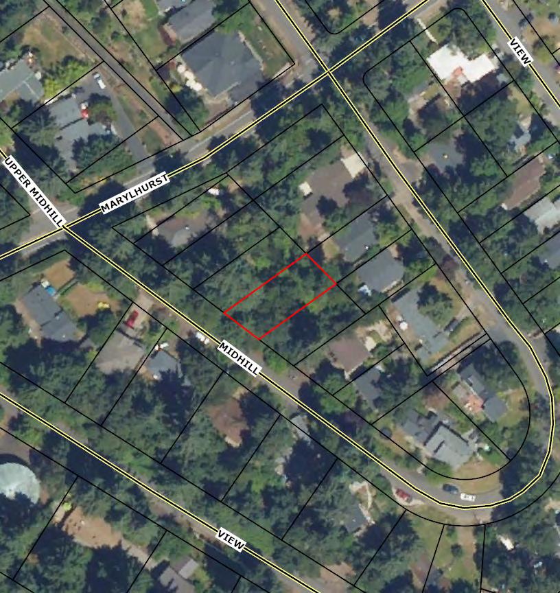
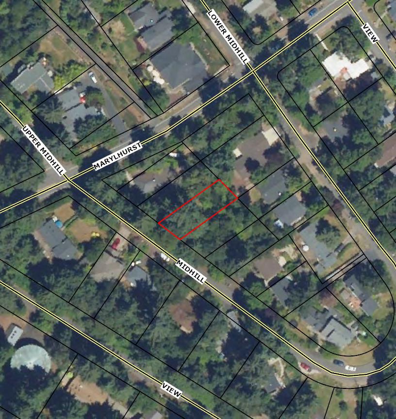
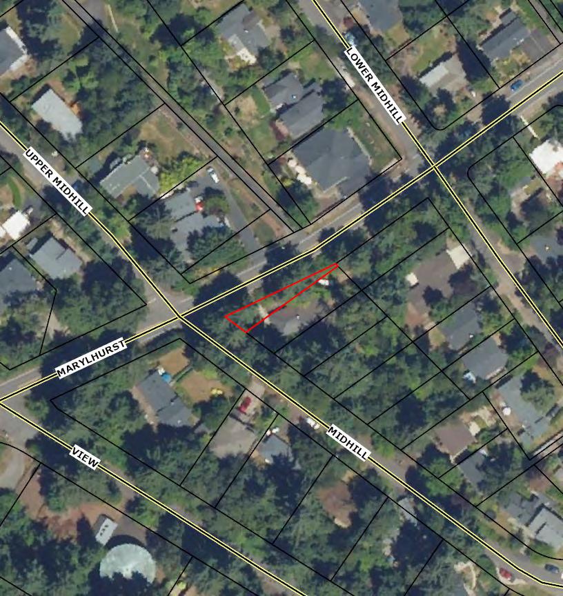
Zoning Map
Community Jurisdiction
The information contained is provided by WFG’s Customer Service Department to our customers, and while deemed reliable, is not guaranteed.
Chapter 05 GENERAL
05.010 PURPOSE
The purpose of the zoning provisions of this code is: to implement the Comprehensive Plan; to provide rules, regulations, and standards governing the use of land and structures; to carry out the development pattern and plan of the City; to promote the public health, safety, and general welfare; to lessen congestion in the streets; to secure safety from fire, flood, pollution, and other dangers; to provide adequate light and air, prevent overcrowding of land, and facilitate adequate provision for transportation, water supply, sewage, and drainage; and to encourage the conservation of energy resources.
05.020 CLASSIFICATIONS OF ZONES
All areas within the corporate limits of the City of West Linn are hereby divided into zone districts, and the use of each tract and ownership of land within the corporate limits shall be limited to those uses permitted by the zoning classification applicable to each such tract as hereinafter designated.The zoning districts within the City of West Linn are hereby classified and designated as follows:
Zoning District
Willamette
Zoning District
Wetland and RiparianArea WRA
Willamette Falls Drive Commercial Design District WFC
A. The boundaries of each of the foregoing districts and the zoning classification and use of each tract in each of said zoning districts are hereby prescribed to coincide with the identifying zone classifications shown on the map entitled “West Linn Zoning Map,” dated with the effective date of this code and signed by the Mayor and City Recorder and hereafter referred to as the “Zoning Map,” and said map by this reference is made a part of this code.Acertified print of the adopted Zoning Map or map amendments shall be maintained in the office of the Community Development Department as long as the code remains in effect.
B. Each lot, tract, and parcel of land, or portion thereof, within the zone boundaries as designated and marked on the Zoning Map, is hereby classified, zoned, and limited to the uses as hereinafter specified and defined for the applicable zone classification.
C. Amendments to the City Zoning Map may be made in accordance with the provisions of Chapters 98 and 99 CDC. Copies of all map amendments shall be dated with the effective date of the document adopting the map amendment and shall be maintained without change, together with the adopting documents, on file in the Community Development Department.The Planning Director shall maintain in their office, and available for public inspection, an up-to-date copy of the City Zoning Map to be revised so that it accurately portrays changes of zone boundaries.
D. The Planning Director shall maintain on a set of zoning maps an index indicating the case number, type of action, and location of actions taken under this code. (Ord. 1621 § 25, 2014)
05.040 DETERMINATION OF ZONING BOUNDARIES
Where due to the scale, lack of scale, lack of detail, or illegibility of the City Zoning Map, or due to any other reason, there is uncertainty, contradiction, or conflict as to the intended location of district boundary lines, determination of zoning boundaries shall be determined by the Planning Director in accordance with the following standards:
A. Boundaries indicated as approximately following the center lines of streets, highways, or alleys shall be construed to follow such center lines.
B. Boundaries indicated as approximately following platted lot or parcel lines shall be construed as following such lot or parcel lines.
C. Boundaries indicated as approximately following City limits shall be construed as following City limits.
D. Boundaries indicated as approximately following river, stream, and/or drainage channels shall be construed as following river, stream, and/or drainage channels.
E. Whenever any street is lawfully vacated, and when the lands within the boundaries thereof attached to and become a part of lands adjoining such street, the lands formerly within the vacated street shall automatically be subject to the same zoning district designation that is applicable to lands to which same attaches. (Ord. 1636 § 4, 2014)
05.050 REVIEW OFANNEXED LAND FOR SOLID WASTE FACILITY SITING
Within a one-year period following annexation of land into the City, the City will determine whether or not the annexed land, where the land is designated for commercial and industrial use, includes appropriate areas for siting solid waste facilities. If commercial or industrial designated land is annexed to the City that is appropriate for siting solid waste facilities, the City will then notify Metro of the need to update this agreement. (Ord. 1442, 1999)
The West Linn Community Development Code is current through Ordinance 1755, passed December 9, 2024.
Disclaimer:The City Recorder's Office has the official version of the West Linn Community Development Code. Users should contact the City Recorder's Office for ordinances passed subsequent to the ordinance cited above.
City Website: https://westlinnoregon.gov/ CityTelephone: (503) 657-0331
Codification services provided by General Code
PERMITTED USES
ACCESSORYUSES 11.050 USESAND DEVELOPMENT PERMITTED UNDER PRESCRIBED CONDITIONS
CONDITIONALUSES
11.070 DIMENSIONALREQUIREMENTS, USES PERMITTED OUTRIGHTAND USES PERMITTED UNDER PRESCRIBED CONDITIONS
11.080 DIMENSIONALREQUIREMENTS, CONDITIONALUSES 11.090 OTHERAPPLICABLE DEVELOPMENT STANDARDS
11.010 PURPOSE
The purpose of this zone is to provide for urban development at levels which relate to the site development limitations, proximity to commercial development and to public facilities and public transportation.This zone is intended to implement the Comprehensive Plan policies and locational criteria, and is applicable to areas designated as Low Density Residential on the Comprehensive Plan Map andType I andType II lands identified under the Buildable Lands Policy. (Ord. 1745 § 1 (Exh.A), 2023)
11.020 PROCEDURESANDAPPROVALPROCESS
A. Ause permitted outright, CDC 11.030, is a use which requires no approval under the provisions of this code, except that some uses require design review pursuant to CDC 11.090(B). If a use is not listed as a use permitted outright, it may be held to be a similar unlisted use under the provisions of Chapter 80 CDC.
B. Ause permitted under prescribed conditions (CDC 11.050) is a use for which approval will be granted provided all conditions are satisfied, and:
1. The Planning Director shall make the decision in the manner provided by CDC 99.060(A)(2), Administrative Procedures, except that no notice shall be required; and
2. The decision may be appealed by the applicant to the Planning Commission as provided by CDC 99.240(A).
C. Aconditional use (CDC 11.060) is a use the approval of which is discretionary with the Planning Commission.The approval process and criteria for approval are set forth in Chapter 60 CDC, Conditional Uses. If a use is not listed as a conditional use, it may be held to be a similar unlisted use under the provisions of Chapter 80 CDC.
D. The following code provisions may be applicable in certain situations:
1. Chapter 65 CDC, Non-conforming Uses Involving a Structure.
2. Chapter 66 CDC, Non-conforming Structures.
3. Chapter 67 CDC, Non-conforming Uses of Land.
4. Chapter 68 CDC, Non-conforming Lots, Lots of Record.
Accessory uses are allowed in this zone as provided by Chapter 34 CDC. (Ord. 1745 § 1 (Exh.A), 2023)
11.050 USESAND DEVELOPMENT PERMITTED UNDER
PRESCRIBED CONDITIONS
The following uses are allowed in this zone under prescribed conditions.
1. Home occupations, subject to the provisions of Chapter 37 CDC.
2. Sign, subject to the provisions of Chapter 52 CDC.
3. Temporary uses, subject to the provisions of Chapter 35 CDC.
4. Water-dependent uses, subject to the provisions of Chapters 28 and 34 CDC.
5. Agricultural or horticultural use; provided, that no retail or wholesale business sales office is maintained on the premises; and provided, that poultry or livestock shall not be permitted within 100 feet of any residence other than a dwelling on the same lot, nor on a lot of less than one acre, or which has less than 20,000 feet per head of livestock.These uses are subject to the nuisance provisions found in Section 5.400 et seq. of the West Linn Municipal Code.
6. Wireless communication facilities, subject to the provisions of Chapter 57 CDC. (Ord. 1298, 1991; Ord. 1308, 1991; Ord. 1408, 1998; Ord. 1565, 2008; Ord. 1624 § 5, 2014; Ord. 1635 § 9, 2014; Ord. 1745 § 1 (Exh.A), 2023)
11.060 CONDITIONALUSES
The following are conditional uses which may be allowed in this zoning district subject to the provisions of Chapter 60 CDC, Conditional Uses.
1. Cultural exhibits and library services.
2. Lodge, social, community center and civic assembly.
11.070 DIMENSIONALREQUIREMENTS, USES PERMITTED OUTRIGHTAND USES PERMITTED UNDER PRESCRIBED CONDITIONS
Except as may be otherwise provided by the provisions of this code, the following are the requirements for uses within this zone:
STANDARD
Minimum lot size
REQUIREMENT ADDITIONALNOTES
Average minimum lot or parcel size for a townhouse project 10,000 sf 1,500 sf
Minimum lot width at front lot line
Average minimum lot width
Minimum yard dimensions or minimum building setbacks
35 ft
50 ft
For a single-family attached or detached unit
Does not apply to townhouses or cottage clusters
Does not apply to townhouses or cottage clusters
Except as specified in CDC 25.070(C)(1) through (4) for the Willamette Historic District. Front, rear, and side yard setbacks in a cottage cluster project are 10 ft.There are no additional setbacks for individual structures on individual lots, but minimum distance between structures shall follow applicable building code requirements.
STANDARD
REQUIREMENT ADDITIONALNOTES
Front yard 20 ft
side yard
Maximum building height
Maximum lot coverage 35%
Except for steeply sloped lots where the provisions of CDC 41.010 shall apply
Townhouse common walls that are attached may have a 0-ft side setback.
Except for steeply sloped lots in which case the provisions of Chapter 41 CDC shall apply.
Maximum lot coverage does not apply to cottage clusters. However, the maximum building footprint for a cottage cluster is less than 900 sf per dwelling unit.
• This does not include detached garages, carports, or accessory structures.
• Adeveloper may deduct up to 200 sf for an attached garage or carport.
Minimum accessway width to a lot which does not abut a street or a flag lot
Maximum floor area ratio
Maximum FAR does not apply to cottage clusters.
STANDARD
REQUIREMENT ADDITIONALNOTES
Duplex, triplex, and quadplex 0.60 Type I and II lands shall not be counted toward lot area when determining allowable floor area ratio, except that a minimum floor area ratio of 0.30 shall be allowed regardless of the classification of lands within the property. That 30 percent shall be based upon the entire property, includingType I and II lands. Existing residences in excess of this standard may be replaced to their prior dimensions when damaged without the requirement that the homeowner obtain a nonconforming structures permit under Chapter 66 CDC.
Except as may otherwise be established by this code, the appropriate lot or parcel size for a conditional use shall be determined by the approval authority at the time of consideration of the application based upon the criteria set forth in CDC 60.070(A) and (B). (Ord. 1636 § 9, 2014; Ord. 1745 § 1 (Exh.A), 2023)
11.090 OTHERAPPLICABLE DEVELOPMENT STANDARDS
A. The following standards apply to all development including permitted uses:
4. Chapter 41 CDC, Building Height, Structures on Steep Lots, Exceptions.
5. Chapter 42 CDC, Clear VisionAreas.
6. Chapter 44 CDC, Fences.
7. Chapter 46 CDC, Off-Street Parking, Loading and ReservoirAreas.
8. Chapter 48 CDC,Access, Egress and Circulation.
9. Chapter 52 CDC, Signs.
10. Chapter 54 CDC, Landscaping.
B. The provisions of Chapter 55 CDC, Design Review, apply to all uses except attached and/or detached single-family dwellings, cottage clusters, townhouses, manufactured homes, accessory dwelling units, residential homes and residential facilities. (Ord. 1590 § 1, 2009; Ord. 1675 § 9, 2018; Ord. 1736 § 1 (Exh.A), 2022; Ord. 1745 § 1 (Exh.A), 2023)
The West Linn Community Development Code is current through Ordinance 1755, passed December 9, 2024.
Disclaimer:The City Recorder's Office has the official version of the West Linn Community Development Code. Users should contact the City Recorder's Office for ordinances passed subsequent to the ordinance cited above.
City Website: https://westlinnoregon.gov/
CityTelephone: (503) 657-0331
Codification services provided by General Code
LOT SIZE SETBACK & HEIGHT REQUIREMENTS
SIZES
10,000 sq. ft. unless an existing lot of record
DIMENSIONAL REQUIREMENTS BY ZONE
RESIDENTIAL
COMMERCIAL
INDUSTRIAL
(a) 20’ for garage
(b) Depends on location of building type
(c) Maxmum 20’ when fronting an arterial roadway
(d) Same as abutting residential district with at least 10’ landscaped in addition to fence.
(e) See CDC Ch. 41, R‐3 thru R10 45 ft in steep lots
(f) See CDC Ch. 41, R‐3 thru R10 45 ft in steep lots
EXCEPTIONS
Planned Unit Development (PUD) may provide developers with the opportunity to introduce a range of housing types; including multi‐family, into a single‐family residential zone.
Lot dimension and setbacks may be modified if developed as a PUD.
If there is a dwelling on one abutting lot with a front yard of less depth then the required depth for the zone, the front yard for the lot need not exceed a depth one‐half between the depth of the abutting lot and the required front yard depth.
If there are dwellings on both abutting lots with front yard depths less that the required depth for the zone, the depth of the front yard for the intervening lot need not exceed the average depth of the front yards of the abutting lots.
On building site of over 25% grade, garages may be located within three feet of the front lot line according to Section 41.010 of the West Linn Community Development Code.
Flag lots can be created where it can be shown that no other reasonable street access is possible. (See dimensional requirements in Section 85.200(B)7 of the CDC.)
Decks, porches, balconies, bay windows and other kinds of structural features may project into yard areas. (See CDC Chapters 34 or 38 for details.)
MU district has 5,000 sq. ft. maximum ground floor size and 6,000 sq. ft. total building size
SIDE YARD TRANSITIONS
New house construction or remodels to the side wall of existing homes shall transition to homes on either side by one of two methods (A), (B) or satisfy one of the exemptions (C) (1‐6) listed below:
A. The side elevation of the house must be divided into smaller areas or planes to minimize the appearance of bulk when viewed from the neighboring properties or a side street. When the side elevation of the house is more than 700 square feet in area, the elevation must be divided into distinct planes of 700 square feet or less. For the purpose of the standard, a distinct plane is created when there is a recessed or projecting section of the structure, that projects or recedes a least two feet, for a length of at least six feet.
Side elevation
Two-foot pop out
700 square foot of vertical space of elevation (any combination of height x width) requires a two‐foot indentation or pop out.
B. The height of the sidewall shall not exceed 22 feet measured from grade at the mid‐point of the sidewall to the eaves. Sidewall can resume vertically after minimum 7.5’ setback. 22 feet
feet
Sidewalls less than 22 feet high to eaves from average grade are exempt from popout/indentation requirement. Sidewall can resume vertically if set back 7.5 feet.
C. Exemptions
1. The side of homes that are built 20 feet or more from the side lot line.
2. Homes on steep lots where the peak of the roof would be more than 24 feet above the average street grade.
3. Homes on narrow lots 50 feet wide or less shall be allowed a minimum side‐to‐side width of 30 feet for floors above the first floor. The 30‐foot wide floor shall be able to accommodate a nine‐foot floor‐to‐ceiling measurement on the second floor.
4. Homes whose side yard are contiguous to an open space, unbuildable area, or non‐residentially zoned lands are exempt. (No exemption if adjacent to a park.)
5. Houses that have the gable end facing the side lot line are exempt.
6. Replacement in kind of building materials on the sidewall of an existing house. For example, the replacement of siding would be exempt.
EXEMPTIONS FROM SIDE WALL STANDARD
Homes that are built 20’ or more from the side lot line 1.
Homes on steep lots where the roof would be no more than 24’ above average grade 2.
Homes on lots 50’ wide or less can have second floor width of at least 50 feet 3.
4.
Home next to open space, etc.
Homes with the gable end facing the side lot line
5.
The material and information on this website are made available for general informational purposes only. Although Metro makes reasonable efforts to ensure the accuracy, completeness, and currency of this information, the data and maps may contain errors or inaccuracies. No representations or warranties of any kind, express or implied, are provided.
Address
City
County Clackamas
Metro councilor Christine Lewis
Metro councilor email
Land Use and Planning
Urban growth boundary Inside
Sub-watershed Oswego Creek-Willamette River
Basin Willamette
Sub-basin Lower Willamette
Urban
Residential hauler West Linn Refuse and Recycling, Inc.
Residential hauler phone (503) 557-3900
Commercial hauler West Linn Refuse and Recycling, Inc.
Commercial hauler phone (503) 557-3900
Dropbox provider Republic Services
Dropbox provider phone (503) 981-1278
School district WEST LINN-WILSONVILLE
School district number 3J
Fire district Tualatin Valley Fire and Rescue District
Park district No data
Sewer district Tri-City Service District
Water district
No data
The material and information on this website are made available for general informational purposes only. Although Metro makes reasonable efforts to ensure the accuracy, completeness, and currency of this information, the data and maps may contain errors or inaccuracies. No representations or warranties of any kind, express or implied, are provided.
Address
City
County Clackamas
State
Taxlot Information
Taxlot ID
Metro councilor Christine Lewis
Metro councilor email
Land Use and Planning
Urban growth boundary Inside
Sub-watershed Oswego Creek-Willamette River
Basin Willamette
Sub-basin Lower Willamette
Urban
Residential hauler West Linn Refuse and Recycling, Inc.
Residential hauler phone (503) 557-3900
Commercial hauler West Linn Refuse and Recycling, Inc.
Commercial hauler phone (503) 557-3900
Dropbox provider Republic Services
Dropbox provider phone (503) 981-1278
School district WEST LINN-WILSONVILLE
School district number 3J
Fire district Tualatin Valley Fire and Rescue District
Park district No data
Sewer district Tri-City Service District
Water district
No data
The material and information on this website are made available for general informational purposes only. Although Metro makes reasonable efforts to ensure the accuracy, completeness, and currency of this information, the data and maps may contain errors or inaccuracies. No representations or warranties of any kind, express or implied, are provided.
City
County Clackamas
State
Taxlot Information
Metro councilor Christine Lewis
Metro councilor email
Land Use and Planning
Urban growth boundary Inside
Sub-watershed Oswego Creek-Willamette River
Basin Willamette
Sub-basin Lower Willamette
Urban
Residential hauler West Linn Refuse and Recycling, Inc.
Residential hauler phone (503) 557-3900
Commercial hauler West Linn Refuse and Recycling, Inc.
Commercial hauler phone (503) 557-3900
Dropbox provider Republic Services
Dropbox provider phone (503) 981-1278
School district WEST LINN-WILSONVILLE
School district number 3J
Fire district Tualatin Valley Fire and Rescue District
Park district No data
Sewer district Tri-City Service District
Water district
No data
The material and information on this website are made available for general informational purposes only. Although Metro makes reasonable efforts to ensure the accuracy, completeness, and currency of this information, the data and maps may contain errors or inaccuracies. No representations or warranties of any kind, express or implied, are provided.
Summary data
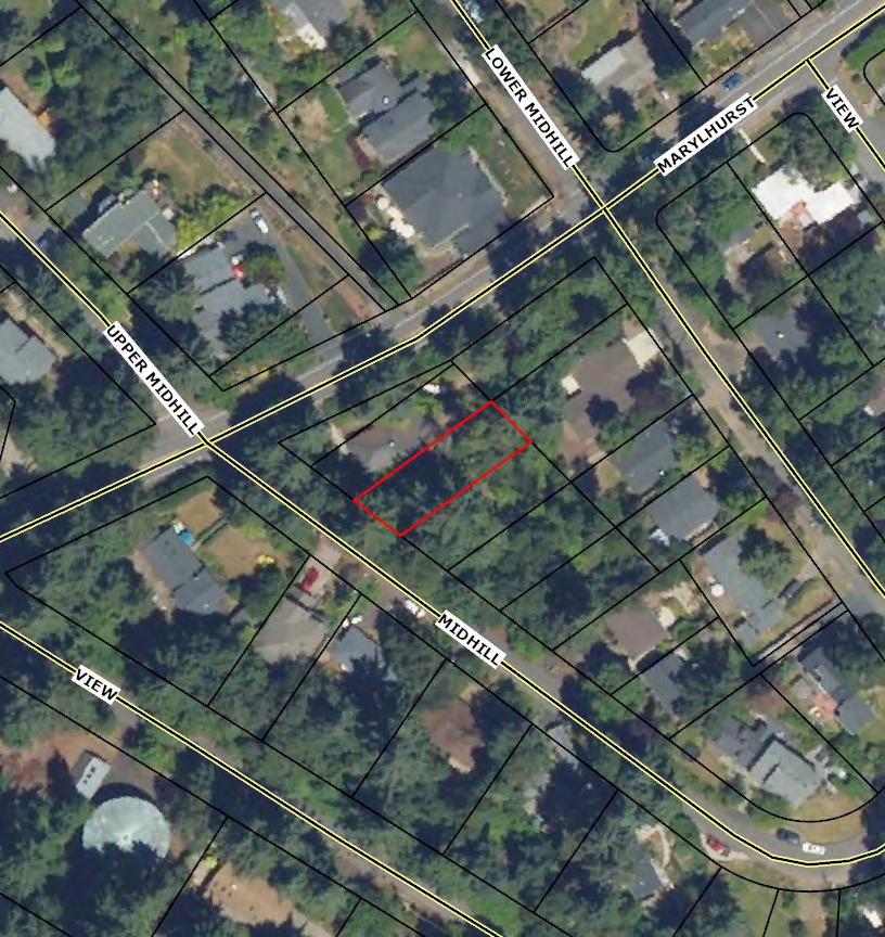
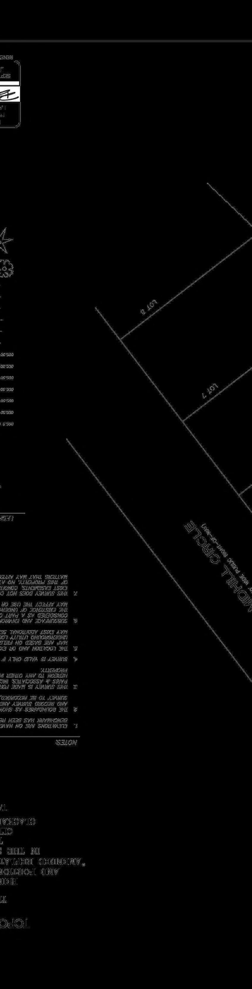
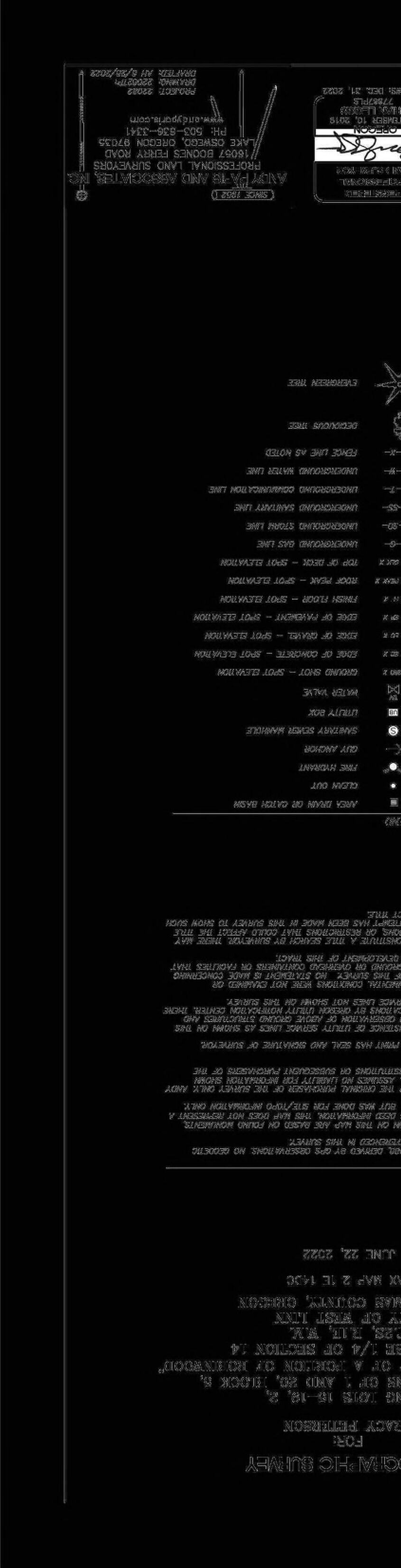
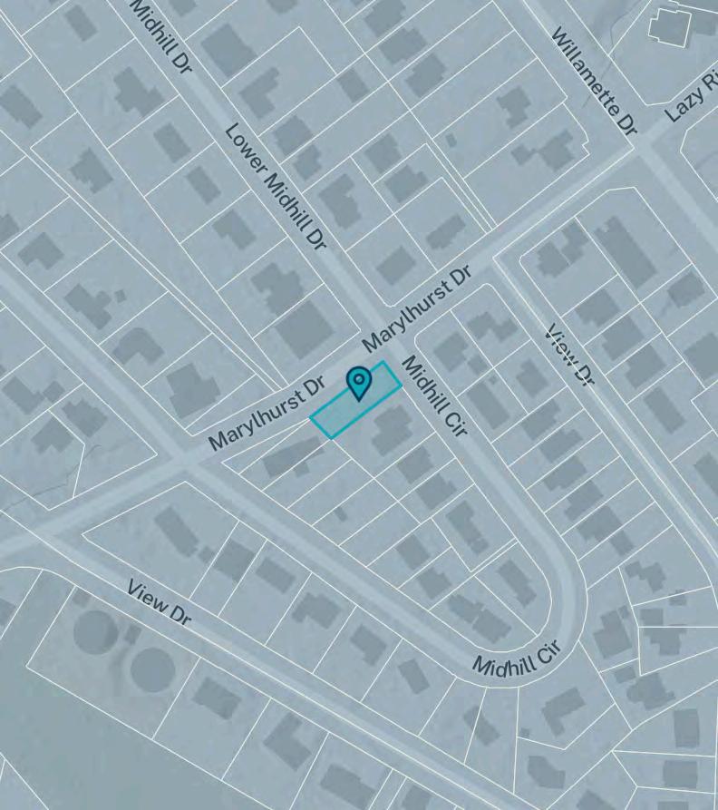
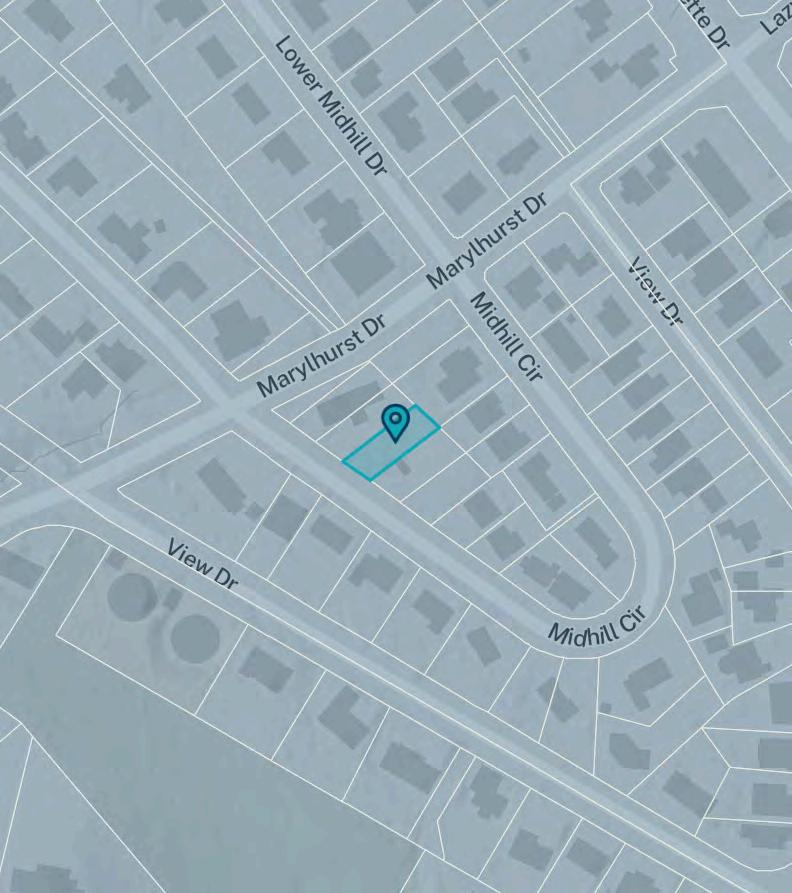
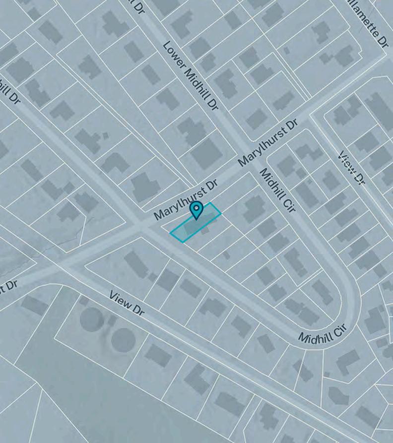
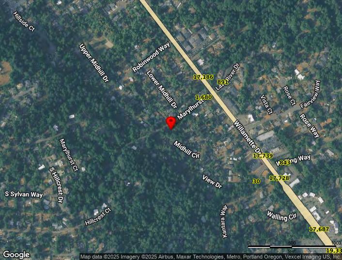
Site Location
Address
City
County Clackamas
State No data
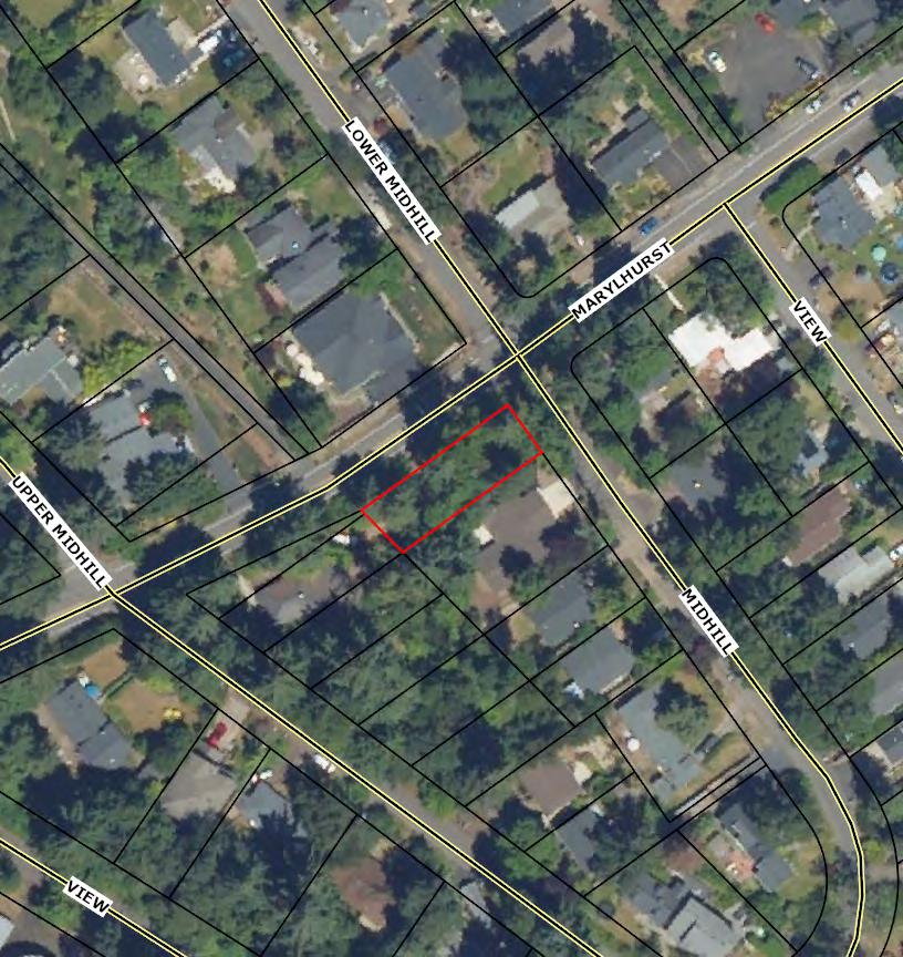
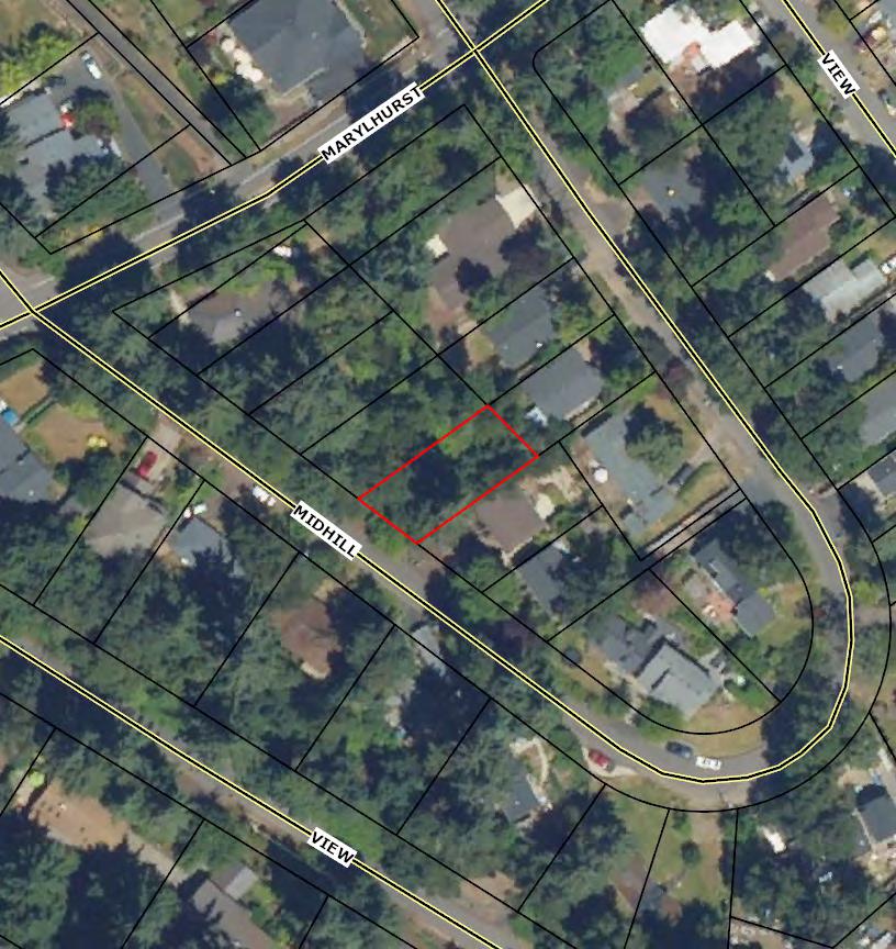
Coordinates (45.390391, -122.648002)
Taxlot Information
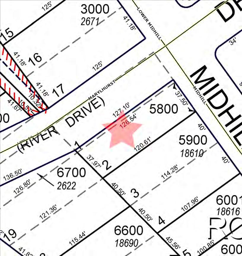
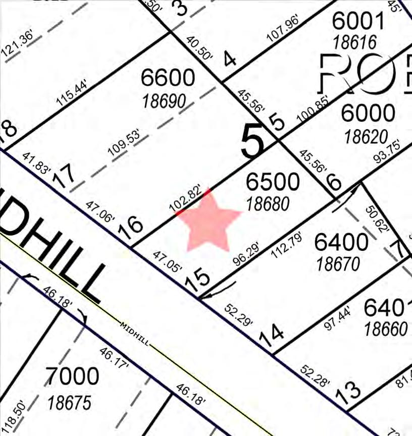
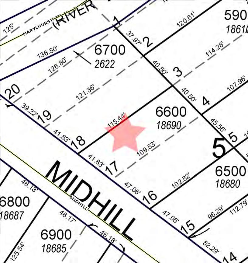
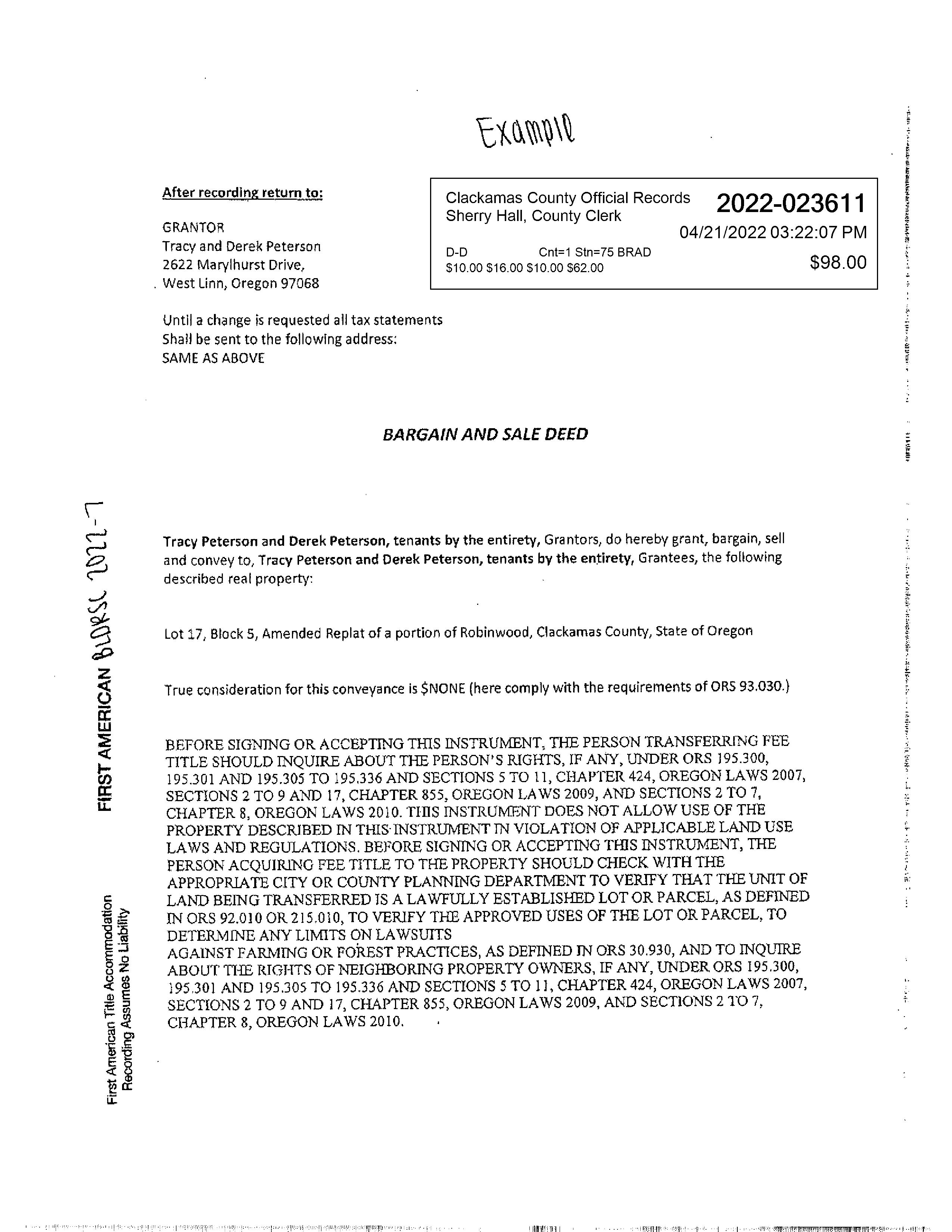
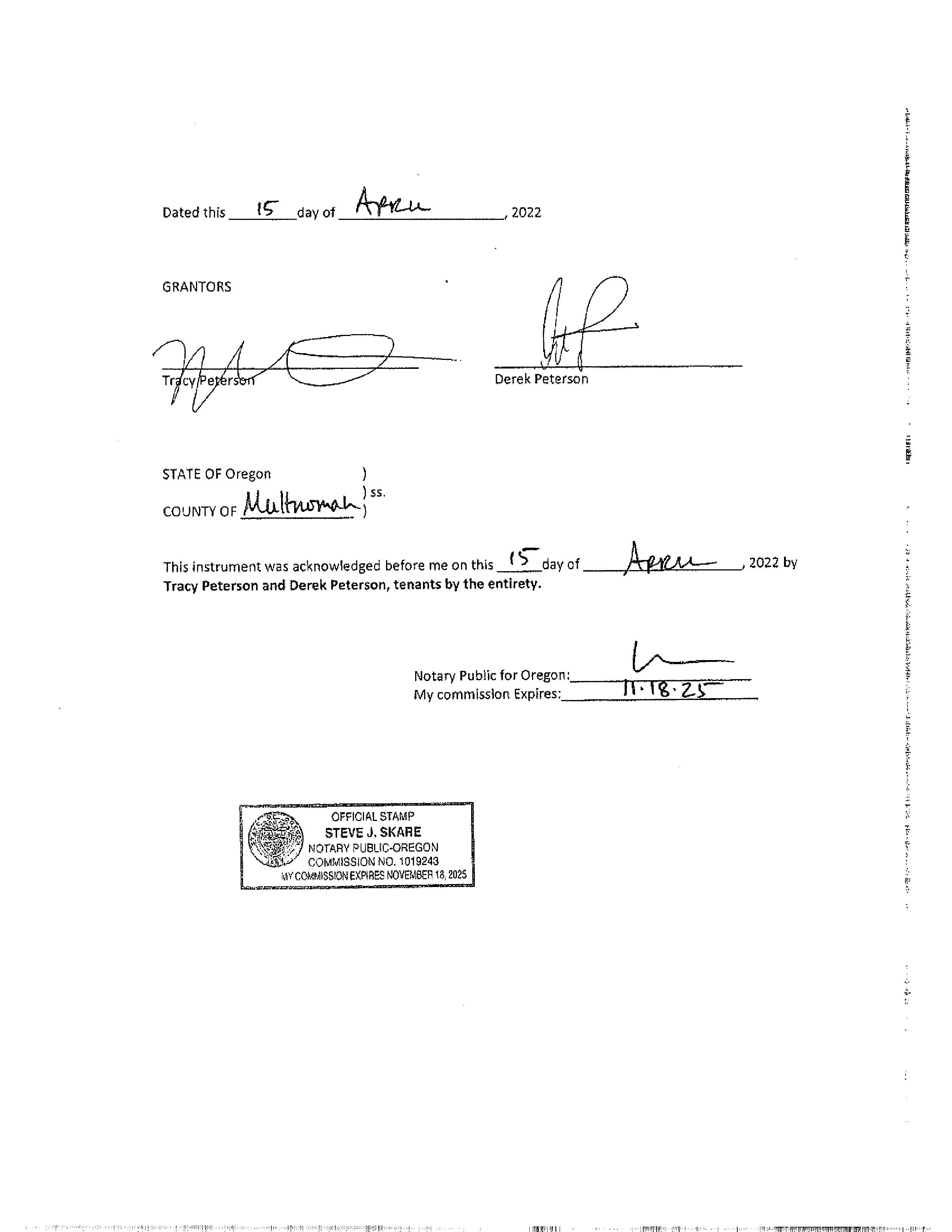
Taxlot ID 21E14DC06601
Taxlot area 0.10 acres
Sale price Unavailable
Date
Metro councilor Christine Lewis
Metro councilor email
Land Use and Planning
Urban growth boundary Inside
Sub-watershed Oswego Creek-Willamette River
Basin Willamette
Sub-basin Lower Willamette
Urban
Residential hauler West Linn Refuse and Recycling, Inc.
Residential hauler phone (503) 557-3900
Commercial hauler West Linn Refuse and Recycling, Inc.
Commercial hauler phone (503) 557-3900
Dropbox provider Republic Services
Dropbox provider phone (503) 981-1278
School district WEST LINN-WILSONVILLE
School district number 3J
Fire district Tualatin Valley Fire and Rescue District
Park district No data
Sewer district Tri-City Service District
Water district
No data
The material and information on this website are made available for general informational purposes only. Although Metro makes reasonable efforts to ensure the accuracy, completeness, and currency of this information, the data and maps may contain errors or inaccuracies. No representations or warranties of any kind, express or implied, are provided.
Address
County Clackamas State OR
Metro councilor Christine Lewis
Metro councilor email
Land Use and Planning
Urban growth boundary Inside
Sub-watershed Oswego Creek-Willamette River
Basin Willamette
Sub-basin Lower Willamette
Urban
Residential hauler West Linn Refuse and Recycling, Inc.
Residential hauler phone (503) 557-3900
Commercial hauler West Linn Refuse and Recycling, Inc.
Commercial hauler phone (503) 557-3900
Dropbox provider Republic Services
Dropbox provider phone (503) 981-1278
School district WEST LINN-WILSONVILLE
School district number 3J
Fire district Tualatin Valley Fire and Rescue District
Park district No data
Sewer district Tri-City Service District
Water district
No data
The material and information on this website are made available for general informational purposes only. Although Metro makes reasonable efforts to ensure the accuracy, completeness, and currency of this information, the data and maps may contain errors or inaccuracies. No representations or warranties of any kind, express or implied, are provided.
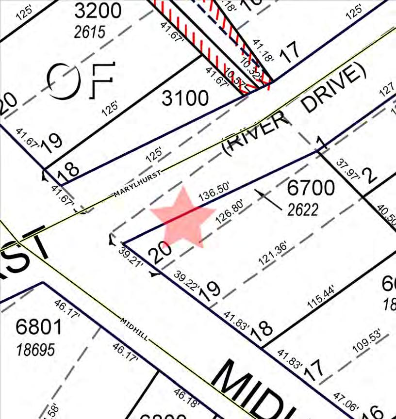
Summary data
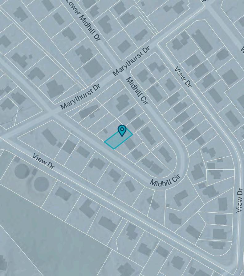
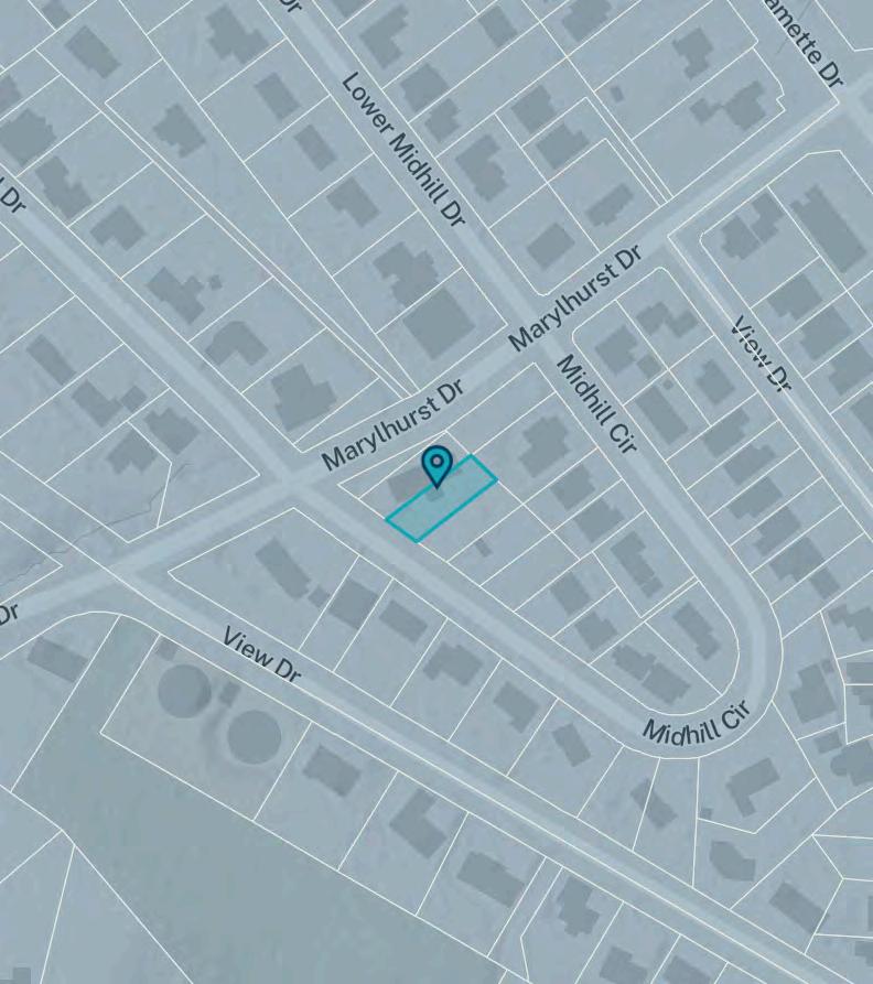
Site Location
Address
City
Coordinates (45.390494, -122.648172)
Taxlot Information
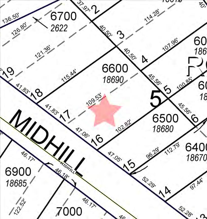
Taxlot ID 21E14DC06701
Taxlot area 0.11 acres
Metro councilor Christine Lewis
Metro councilor email
Land Use and Planning
Urban growth boundary Inside
Sub-watershed Oswego Creek-Willamette River
Basin Willamette
Sub-basin Lower Willamette
Urban
Residential hauler West Linn Refuse and Recycling, Inc.
Residential hauler phone (503) 557-3900
Commercial hauler West Linn Refuse and Recycling, Inc.
Commercial hauler phone (503) 557-3900
Dropbox provider Republic Services
Dropbox provider phone (503) 981-1278
School district WEST LINN-WILSONVILLE
School district number 3J
Fire district Tualatin Valley Fire and Rescue District
Park district No data
Sewer district Tri-City Service District
Water district
No data
The material and information on this website are made available for general informational purposes only. Although Metro makes reasonable efforts to ensure the accuracy, completeness, and currency of this information, the data and maps may contain errors or inaccuracies. No representations or warranties of any kind, express or implied, are provided.
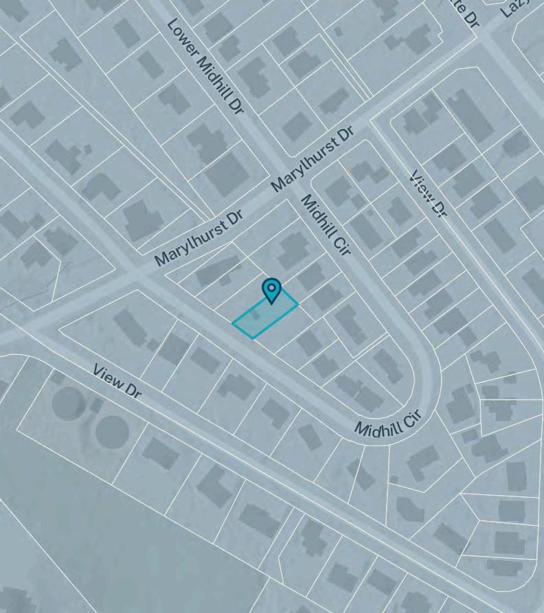
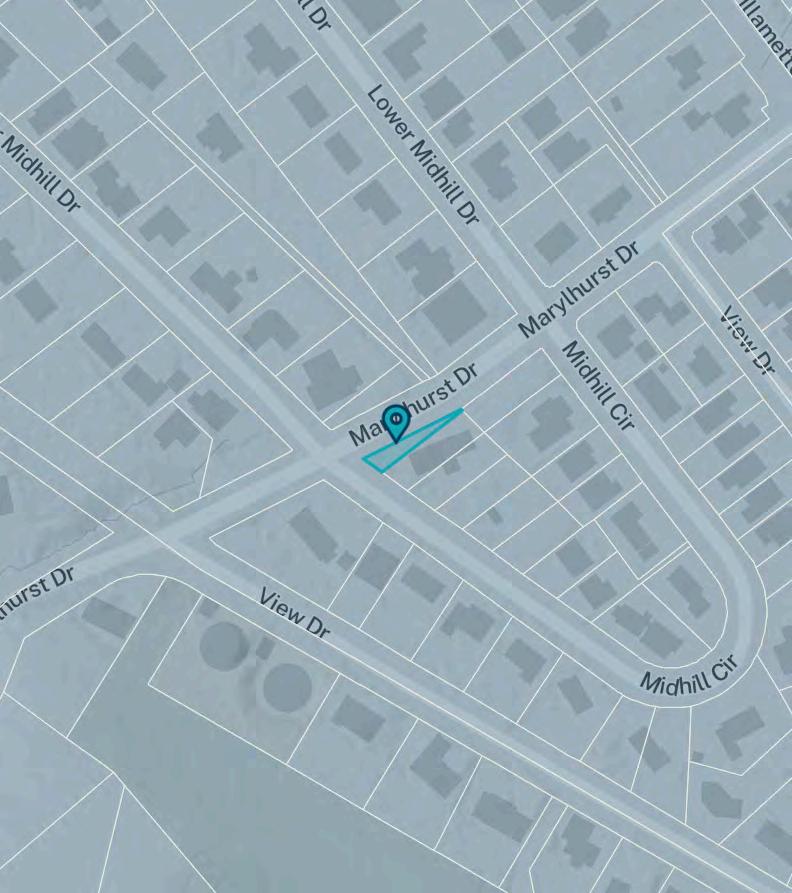
Site Location
Address
County Clackamas
State No data
Coordinates (45.390559, -122.64845)
Taxlot Information
Taxlot ID 21E14DC06702
Taxlot area 0.05 acres
Sale price Unavailable
Metro councilor Christine Lewis
Metro councilor email
Land Use and Planning
Urban growth boundary Inside
Sub-watershed Oswego Creek-Willamette River
Basin Willamette
Sub-basin Lower Willamette
Urban
Residential hauler West Linn Refuse and Recycling, Inc.
Residential hauler phone (503) 557-3900
Commercial hauler West Linn Refuse and Recycling, Inc.
Commercial hauler phone (503) 557-3900
Dropbox provider Republic Services
Dropbox provider phone (503) 981-1278
School district WEST LINN-WILSONVILLE
School district number 3J
Fire district Tualatin Valley Fire and Rescue District
Park district No data
Sewer district Tri-City Service District
Water district
No data
Topography
CUSTOM
MAPS
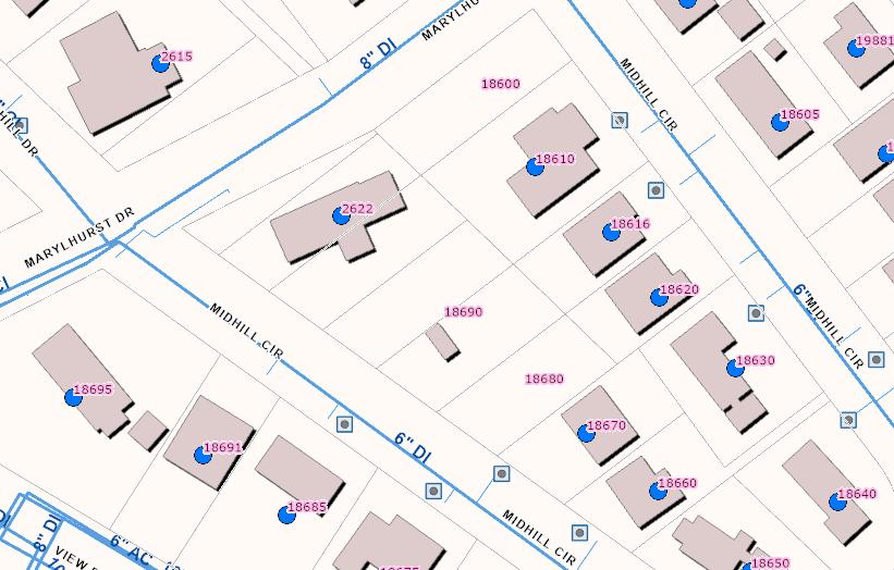
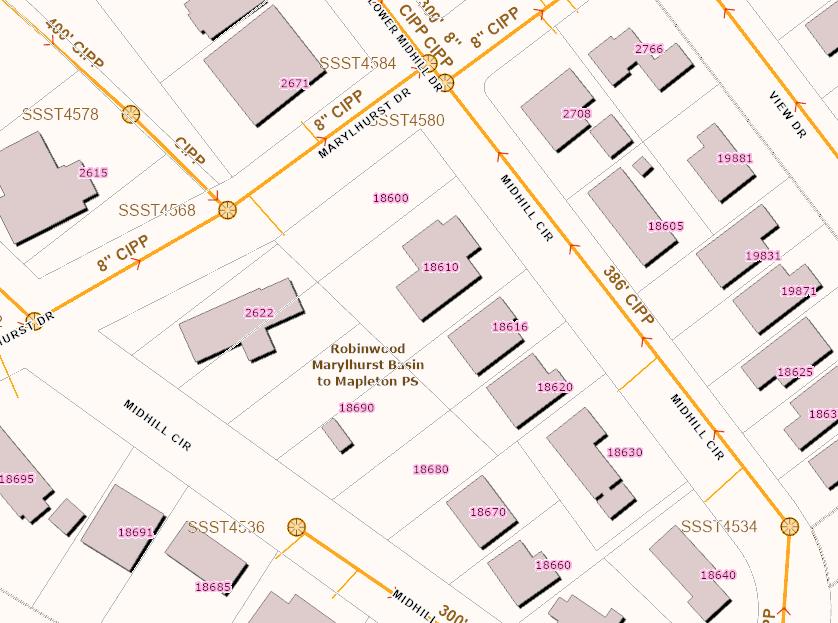
Water Features
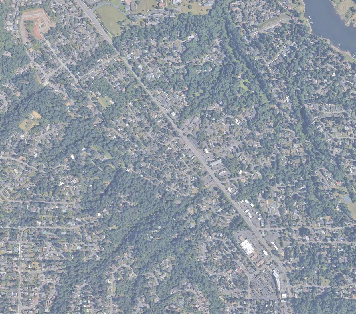
Aerial
Aerial Environmental
Community
Transit
Vacant Land
The information contained is provided by WFG’s Customer Service Department to our customers, and while deemed reliable, is not guaranteed.
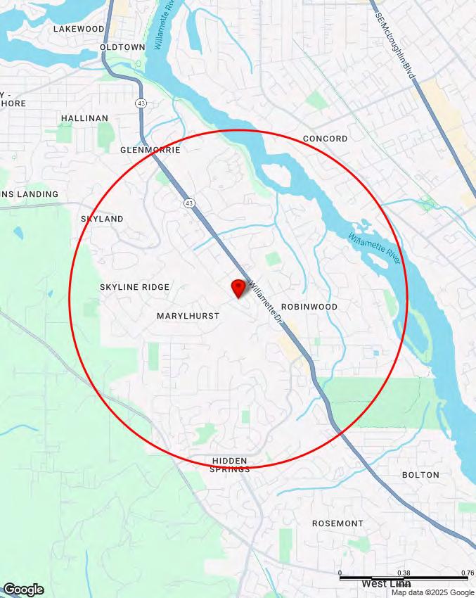
VIEWDR MIDHILLCIR
CO UNCLAIMED #4
Heron Creek Marylhurst University
KinderCare - West Linn
²603-1700
The Columbia Academy
Park Primary
Cedaroak
SKYLANDS
CLACKAMAS
ROBINWOOD
SKYLINE RIDGE
STAFFORD-TUALATIN VALLEY HIDDEN SPRINGS
MARYLHURST
OAK GROVE COMMUNITY COUNCIL
COMMUNITY
Demographics
Traffic Counts INFORMATION
The information contained is provided by WFG’s Customer Service Department to our customers, and while deemed reliable, is not guaranteed.
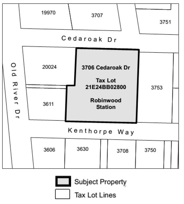
21E14DC 5800,6700,6701,6702,6600,6601,6500, West Linn, OR 97068
Gift, novelty, and souvenir stores (NAICS 45322) $791,076 $
$713,882
Used merchandise stores (NAICS 4533) $1,021,588 $719,149 $302,440
Other miscellaneous store retailers (NAICS 4539) $4,116,508 $3,212,816 $903,693 Pet and pet supplies stores (NAICS 45391) $1,120,597 $2,006,478 -$885,881
Art dealers (NAICS 45392) $670,201 $ 84,226 $585,974
Manufactured (mobile) home dealers (NAICS 45393) $561,837 $ 0 $561,837
All other miscellaneous store retailers (NAICS 45399) $1,763,874 $1,122,111 $641,763 Tobacco stores (NAICS 453991) $416,506 $940,901 -$524,395
All other miscellaneous store retailers (except tobacco stores) (NAICS 453998) $1,347,368 $181,210 $1,166,157
Retail Market Power data is derived from two major sources of information. The demand data is derived from the Consumer Expenditure Survey (CE Survey or CEX), which is fielded by the U.S. Bureau of Labor Statistics (BLS). The supply data is derived from the Census of Retail Trade (CRT), which is made available by the U.S. Census. Additional data sources are incorporated to create both supply and demand estimates. The difference between demand and supply represents the opportunity gap or surplus available for each merchandise line in the specified reporting geography. When this difference is positive (demand is greater than the supply), there is an opportunity gap for that merchandise line; when the difference is negative (supply is greater than demand), there is a surplus.