Development Standards
A. Purpose. A broad range of housing types are allowed in the multi-dwelling zones. This range allows for efficient use of land, provides options to increase housing variety and housing opportunities, and promotes affordable and energy-efficient housing.
B. Housing types. The types of housing allowed in the multi-dwelling zones are stated in Table 120-2.
Table 120-2
Housing Types Allowed In The Multi-Dwelling Zones
House
(See 33.120.270 C.)
Accessory dwelling unit (See 33.205)
Duplex
Attached Duplex (See 33.120.270.F)
Triplex
Dwelling (See Chapter 33.251)
Dwelling Park (See Chapter 33.251)
Houseboat (See Chapter 33.236)
Congregate Housing Facility
Yes = allowed; No = prohibited.
Notes:
[1] The only type of multi-dwelling development allowed in the RMP zone is manufactured dwellings in a manufactured dwelling park.
[2] Except on individual lots created under the provisions of 33.642, Land Divisions of Manufactured Dwelling Parks, manufactured dwellings are only allowed in manufactured dwelling parks.
33.120.205 When Primary Structures are Allowed
A. Purpose. The regulations of this section require lots, adjusted lots, lot remnants, and lots of record to be an adequate size so that new development on a site will in most cases be able to comply with all site development standards, including density. Allowing the ownership to be separated may increase opportunities for residential infill while preserving existing housing.
Chapter 33.120
33, Planning and Zoning
B. Where these regulations apply. These regulations apply to lots, adjusted lots, lot remnants, and lots of record in the multi-dwelling zones. The creation of new lots is subject to the lot size standards listed in Chapter 33.612, Lots in Multi-Dwelling Zones.
C. Primary structures allowed. Development of a primary structure is allowed as follows:
1. On a lot or adjusted lot created on or after July 26, 1979;
2. On a lot created through the Planned Development or Planned Unit Development process;
3. On a lot, adjusted lot, lot remnant or lot of record that did not abut a lot, adjusted lot, lot remnant, or lot of record, under the same ownership on July 26, 1979, and has not abutted a lot, adjusted lot, lot remnant, or lot of record under the same ownership since July 26, 1979;
4. On a lot or adjusted lot or combination thereof that either:
a. Meets the minimum lot size requirements in Table 120-3; or
b. Does not meet the lot size requirements in Table 120-3, but meets all of the following:
(1) No portion of the lot, adjusted lot or combination is in an Environmental, River Environmental, or Pleasant Valley Natural Resources overlay zone;
(2) No portion of the lot, adjusted lot or combination is in the combined flood hazard area; and
(3) The lot, adjusted lot or combination has an average slope of less than 25 percent.
5. On a lot of record or lot remnant or combination thereof that meets the minimum lot size requirements of Table 120-3.
Table 120-3
Minimum Lot Size Requirements
RM1 through RM4 Zones
Lot 33 feet wide and 4,000 sq. ft.
Adjusted Lot
Lot Remnant
Lot of Record
RX Zone
Lot 10 foot front lot line
Adjusted Lot
Lot Remnant
Lot of Record
RMP Zone
Lot 70 feet wide and 10,000 sq. ft.
Adjusted Lot
Lot Remnant
Lot of Record
D. Plots. Development is prohibited on plots that are not lots, adjusted lots, lots of record, lot remnants, or tracts.
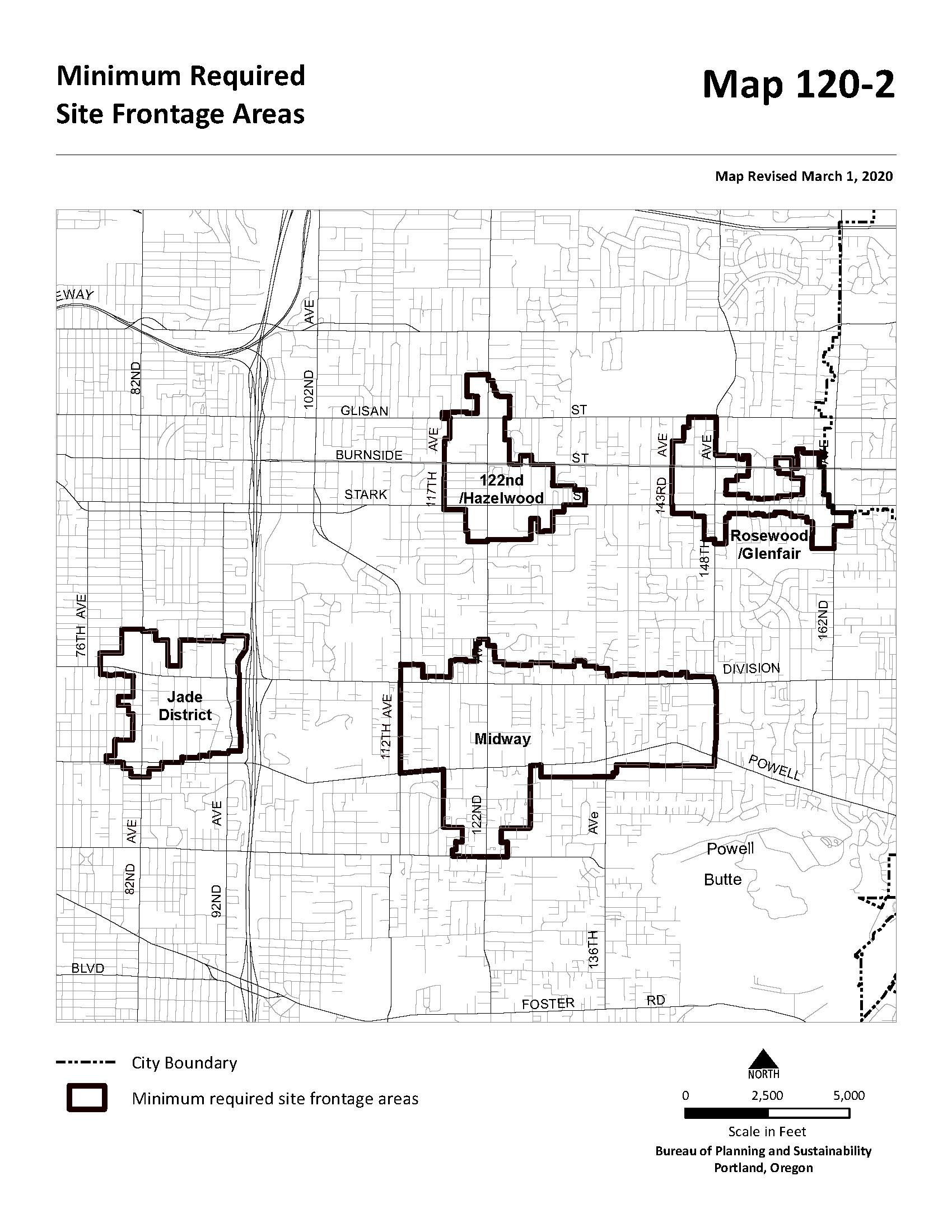
33.120.206 Minimum Required Site Frontage for Development
A. Purpose. The purpose of the minimum required site frontage standard is to ensure that sites in and around certain centers in Eastern Portland have sufficient street frontage and site area to:
• Accommodate new streets where pedestrian, bicycle and vehicular connectivity is lacking;
• Foster efficient site design;
• Allow for buildings with an orientation to the street; and
• Provide opportunities to create outdoor space and preserve trees.
B. Where the standard applies. The minimum required site frontage standard applies in the multi-dwelling zones to sites shown on Map 120-2.
C. Minimum required site frontage standard.
1. Standard. If the site is more than 160 feet deep, new dwelling units are prohibited unless the site has at least 90 feet of frontage on a street. Adjustments to reduce the required amount of frontage by up to 10 percent may be requested prior to January 2, 2032. Beginning January 2, 2032, adjustments are prohibited.
2. Exceptions. The following exceptions apply:
a. Adding an accessory dwelling unit to a lot with an existing house, existing attached house, existing manufactured home, or existing duplex is allowed;
b. Development is allowed on a site when all of the lots that share a side lot line with the development site meets at least one of the following:
(1) The lot is zoned multi-dwelling and meets the minimum density standard for the base zone;
(2) The lot is zoned multi-dwelling and has at least three primary dwelling units on the lot; or
(3) The lot is not zoned multi-dwelling
c. Development approved through a Planned Development Review is allowed. See Chapter 33.270, Planned Development.
Table 120-4
Summary of Development Standards in Multi-Dwelling Zones Standard
Maximum FAR (See 33.120.210)
Maximum Density (See 33.120.212)
Maximum Density with Affordable Housing Bonus (See 33.120.212.C)
Minimum Density (See 33.120.213)
Base Height (See 33.120.215)
Step-down Height (see 33.120.215.B.2
- Within 25 ft. of lot line abutting RF-R2.5 zones
- Within 15 ft. of lot line across a local service street from RF – R2.5 Zones
Minimum Setbacks
- Front building setback
- Side and rear building setback.
- Garage entrance setback
(See 33.120.220)
Maximum Setbacks (See 33.120.220)
Transit Street or Pedestrian District
Max. Building Coverage (See 33.120.225)
Building Length (See 33.120 230)
Landscaped Area (See 33.120.235)
Required Outdoor Areas
(See 33.120.240)
Notes: [1] See
33.120.210 Floor Area Ratio
A. Purpose. Floor area ratios (FARs) regulate the amount of use (the intensity) allowed on a site. FARs provide a means to match the potential amount of uses with the desired character of the area and the provision of public services. FARs also work with the height, setback, and building coverage standards to control the overall bulk of development.
B. FAR standard. The maximum floor area ratios are stated in Table 120-4 and apply to all uses and development. In the RM4 zone the maximum FAR is 4 to 1, except in Historic Districts and Conservation Districts, where the maximum FAR is 3 to 1. Floor area ratio is not applicable in the RMP zone. There is no maximum limit on the number of dwelling units within the allowable floor area, but the units must comply with all building and housing code requirements. Additional floor area may be allowed through bonus options described in Section 33.120.211, or transferred as described in Subsection D. Maximum FAR does not apply to one alteration or addition of up to 250 square feet when the alteration or addition is to a primary structure that received final inspection at least 5 years ago. This exception is allowed once every 5 years. Adjustments to the maximum floor area ratios are prohibited. Floor area does not include the following:
1. Floor area for structured parking when at least 50 percent, or 6, of the parking spaces in the structure, whichever is greater, have at least a Level 2 charger adjacent to the space, up to a maximum of 0.5 to 1;
2. Floor area for required long term bicycle parking that is not located in a dwelling unit, up to a maximum of 0.5 to 1; and
3. Floor area for indoor common area used to meet the requirements of Section 33.120.240.
C. Maximum increase in FAR. An increase in FAR using bonuses and transfers of more than is stated in Table 120-5 is prohibited. This total FAR includes FAR transferred from another site, and any additional FAR allowed from bonus options.
D. Transfer of FAR. FAR may be transferred from one site to another subject to the following:
1. Sending site. FAR may be transferred from:
a. A site where all existing dwelling units are affordable to those earning no more than 60 percent of the area median family income. In order to qualify for this transfer, the applicant must provide a letter from the Portland Housing Bureau certifying that this affordability standard and any administrative requirements have been met. The letter must be submitted before a building permit can be issued for the development, but is not required in order to apply for a land use review;
b. A site where trees that are at least 12 inches in diameter are preserved. The maximum amount of floor area that may be transferred for each preserved tree is indicated in Table 120-5, however the maximum amount of FAR that can be transferred may not exceed the total amount of unused FAR on the site. This transfer provision does not apply to dead, dying or dangerous, or nuisance trees. To qualify for this transfer, a report is required from the City Forester or a
certified arborist documenting that the trees to be preserved are not nuisance trees and are not dead, dying or dangerous; or
c. A site that contains a Historic or Conservation Landmark or a contributing resource in a Historic or Conservation District. Sites that are eligible to send floor area through this transfer are allowed to transfer:
(1) Unused FAR up to the maximum FAR allowed by the zone; and
(2) An additional amount equivalent to 50 percent of the maximum FAR for the zone. To qualify to transfer this additional amount of FAR, Portland Permitting & Development must verify that the landmark or contributing resource on the site meets one of the following:
• If the building is classified as Risk category I or II, as defined in the Oregon Structural Specialty Code, it has been shown to meet or exceed the American Society of Civil Engineers (ASCE) 41- BPOE improvement standard as defined in City of Portland Title 24.85;
• If the building is classified as Risk category III or IV, as defined in the Oregon Structural Specialty Code, it has been shown to meet or exceed the ASCE41- BPON improvement standard as defined in City of Portland Title 24.85; or
• The owner of the landmark or contributing resource has entered into a phased seismic agreement with the City of Portland as described in Section 24.85.
2. Receiving site. The transfer must be to a site zoned RM1, RM2, RM3, RM4, RX, CM1, CM2, CM3, or CE outside of the Central City plan district. Transferring to a site zoned RMP is prohibited. Transferring to a site where a Historic or Conservation Landmark or a contributing structure in a Historic or Conservation District has been demolished within the past ten years is prohibited unless the landmark or contributing structure was destroyed by fire or other causes beyond the control of the owner, the only structure on the site that was demolished was an accessory structure, or the demolition was approved through demolition review.
3. Maximum increase in FAR. An increase in FAR on the receiving site of more than 1 to 1 from a transfer is prohibited. In addition, the total FAR on the receiving site, including FAR from transfers and bonuses, may not exceed the overall maximum FAR with other bonuses stated in Table 120-56.
4. Covenants. The property owner must execute a covenant with the City that meets the requirements of Section 33.700.060 and is attached to, and recorded with, the deeds of both the site transferring and the site receiving the density. The covenant must reflect the respective increase and decrease of potential FAR. In addition, the covenant for the site where trees will be preserved must:
(a) Require that all trees be preserved for at least 50 years; and
(b) Require that any tree covered by the covenant that is dead, dying or dangerous be removed and replaced within a 12-month period. The trees must be determined to be dead, dying, or dangerous by the City Forester or a certified arborist. If a tree covered by the covenant is removed in violation of the
requirements of this Section, or is dead, dying, or dangerous as the result of a violation, Tree Review is required.
Table 120-5
Transferable Floor Area for Tree Preservation in Multi-Dwelling Zones
33.120.211 Floor Area Bonus Options
A. Purpose and description. The bonus options allow additional floor area as an incentive for development that includes affordable housing, family-sized units, or units that are physically accessible to people of all abilities. The bonus options are designed to allow additional development intensity in a manner that is consistent with the purposes of the multi-dwelling zones.
B. General floor area bonus regulations.
1. The floor area bonus options in this section are only allowed in the RM1, RM2, RM3, RM4, and RX zones outside the Central City and Gateway plan districts. Sites where a Historic or Conservation Landmark or a contributing structure in a Historic or Conservation District has been demolished within the past ten years are not eligible to use bonus options unless the landmark or contributing structure was destroyed by fire or other causes beyond the control of the owner, the only structure on the site that was demolished was an accessory structure, or the demolition was approved through demolition review.
2. More than one bonus may be used up to the overall maximum per site stated in Table 120-6. Adjustments to the maximum amount of floor area obtainable through bonuses are prohibited.
3. The increment of additional FAR allowed per bonus is stated in Table 120-6 and described in Subsection C.
4. The bonus option standards must be met in full to receive the bonus.
Overall Maximum Per Site [1]
Maximum FAR with deeper housing affordability bonus (see 33.120.211.C.2)
Increment of Additional FAR Per Bonus Inclusionary Housing (see 33.120.211.C.1)
Deeper Housing Affordability (see 33.120.211.C.2)
Three-Bedroom Units (see 33.120.211.C.3)
Table 120-6
Summary of Bonus FAR
[1] Overall maximum FAR includes FAR received from a transfer.
[2] Other bonuses are the Inclusionary Housing, Three-Bedroom Units, and Visitable Units bonuses.
[3] The lower FAR applies in the RM4 zone in Historic and Conservation districts.
C. Bonus options.
1. Inclusionary housing bonus option. Maximum FAR may be increased as stated in Table 120-6 if one of the following is met:
a. Mandatory inclusionary housing. Bonus FAR is allowed up to the maximum with inclusionary housing bonus stated in Table 120-6 for development that triggers the requirements of 33.245, Inclusionary Housing. To qualify for this bonus, the applicant must provide a letter from the Portland Housing Bureau certifying that the regulations of 33.245 have been met; or
b. Voluntary inclusionary housing. Bonus FAR is allowed up to the maximum with inclusionary housing bonus stated in Table 120-6 when one of the following voluntary bonus options is met:
(1) Bonus FAR is allowed for projects that voluntarily comply with the standards of 33.245.040 and 33.245.050. To qualify for this bonus, the applicant must provide a letter from the Portland Housing Bureau certifying that the regulations of 33.245 have been met. The letter must be submitted before a building permit can be issued for the development, but is not required in order to apply for a land use review; or
(2) Bonus FAR is allowed in exchange for payment into the Affordable Housing Fund. For each square foot of floor area purchased a fee must be paid to the Portland Housing Bureau (PHB). The Portland Housing Bureau collects and administers the Affordable Housing Fund and determines the fee. PHB determines the fee per square foot and updates the fee at least every three years. The fee schedule is available from Portland Permitting & Development. To qualify for this bonus, the applicant must provide a letter from PHB documenting the amount that has been contributed. The letter is required to be submitted before a building permit can be issued for development but is not required in order to apply for a land use review.
2. Deeper housing affordability bonus option. Bonus FAR is allowed up to the maximum with deeper housing affordability bonus as stated in Table 120-6 when at least 50 percent of all the dwelling units on the site are affordable to those earning no more than 60 percent of area median family income or an affordability level established by Title 30. Projects taking advantage of this bonus are also allowed an additional 10 feet of base height and an additional 10 percent of building coverage beyond the limits for the zone stated in Table 120-4. To qualify for this bonus the applicant must provide a letter from the Portland Housing Bureau certifying that the development meets the affordability requirement of this bonus and any administrative requirements of the Portland Housing Bureau. The letter must be submitted before a building permit can be issued for the development but is not required in order to apply for a land use review.
3. Three-bedroom unit bonus option. Bonus FAR is allowed up to the maximum with three-bedroom unit bonus as stated in Table 120-6 if at least 50 percent of the dwelling units on the site have at least three bedrooms and are affordable to those earning no more than 100 percent of the area median family income. To qualify for this bonus, the applicant must provide a letter from the Portland Housing Bureau certifying that the required three-bedroom units meet the affordability requirement of this bonus and any administrative requirements of the Portland Housing Bureau.
4. Visitable units bonus option. Bonus FAR is allowed up to the maximum with visitable units bonus as stated in Table 120-6 when at least 25 percent of all the dwelling units on the site meet the following visitability standards, except that this bonus is not available for projects with buildings that are required by the Oregon Structural Specialty Code to include Type A or Type B accessible units:
a. Visitable entrance. At least one entrance must be accessible via a route that does not have any stairs between it and the street lot line or an on-site parking space. The slope of the route may not exceed 1:8;
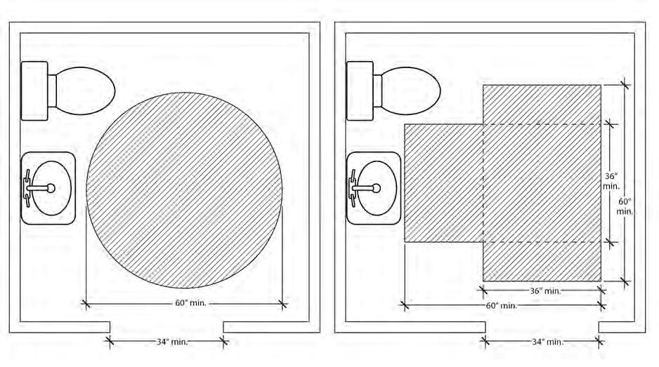
b. Visitable bathroom. At least one bathroom with a sink and toilet must be designed to accommodate an unobstructed circle that is at least 60-inches in diameter. As an alternative, the bathroom may be designed to accommodate an unobstructed area that is comprised of two rectangles that are at least 36 inches by 60 inches, and oriented at right angles to each other. See Figure 120-1. The visitable bathroom must be on the same floor as the visitable entrance or be accessible from the visitable entrance via a ramp, elevator or lift. Adjustments are prohibited;
33.120.212
c. Visitable living area. There must be at least 200 square feet of living area on the same floor as the visitable entrance or 200 square feet of living area must be accessible from the visitable entrance via a ramp, elevator or lift. Adjustments are prohibited; and
d. Visitable doors. All door openings between and including the visitable entrance, visitable living area, and the visitable bathroom must be at least 34 inches wide. Adjustments are prohibited.
Maximum Density
A. Purpose. The maximum number of dwellings per unit of land, the maximum density, is controlled in the RMP zone so that housing can match the availability of public services and the availability of support commercial areas. The standards also allow the housing density to be matched with the carrying capacity of the land. In addition, the density standard is used as one type of control of overall building bulk The bonus density options allow additional floor area as an incentive for providing affordable housing.
B. Maximum density. The maximum density for the RMP zone is stated in Table 120-4. There is no maximum density for any other multi-dwelling zone. All new housing built, or converted from other uses, must be on sites large enough to comply with the density standards. The number of units allowed on a site is based on the presumption that all site development standards will be met. The allowed density is not a special right that justifies adjusting other development standards.
C. RMP zone affordable housing bonus option. In the RMP zone, maximum density can be increased up to the maximum with RMP affordable housing bonus stated in Table 120-4 when at least 50 percent of all of the dwelling units on the site are affordable to those earning no more than 60 percent of area median family income. To qualify for this bonus the applicant must provide a letter from the Portland Housing Bureau certifying that the development meets the affordability requirement of this bonus and any administrative requirements of the Portland Housing Bureau. The letter must be submitted before a building permit can be issued for development, but is not required in order to apply for a land use review.
D. Transfer of density.
1. Density may be transferred from a site zoned RMP to a site zoned RM1, RM2, RM3, or RM4 outside of the Central City plan district. When density will be transferred from a site zoned RMP, one dwelling unit is equal to 800 square feet of floor area. Transfers of density or FAR to a site zoned RMP is prohibited.
2. The property owner must execute a covenant with the City that is attached to, and recorded with, the deed of both the site transferring and the site receiving the density reflecting the respective increase and decrease of potential density. The covenant for the receiving site must meet the requirements of Section 33.700.060.
Visitable Bathroom Clearances
33.120.213 Minimum Density
A. Purpose. The minimum density standards ensure that the service capacity is effectively utilized and that the City's housing goals are met. The standards also ensure that incremental development will not preclude the ability to meet the intended development intensity of the zoning of a site.
B. Minimum density. The minimum density requirements for the multi-dwelling zones are stated in Table 120-4. Group living uses are exempt from minimum density requirements. Land within an Environmental zone may be subtracted from the calculation of minimum density.
1. If units are being added to a site with an existing building with residential units, the minimum density is reduced by two units.
2. In the RMP zone, if maximum density is two units then minimum density is two units. If maximum density is one unit, minimum density is one unit.
3. On sites where trees that are 12 or more inches in diameter are proposed for preservation, minimum density may be reduced as follows:
a. The maximum allowed reduction in minimum density is shown in Table 120-7.
b. When this provision is used to reduce density, the owner must execute a covenant with the City. The covenant is not required if the site is also part of a proposed Land Division. The covenant must:
(1) Require that all trees used to reduce the minimum density be preserved for at least 10 years;
Figure 120-1
(2) Allow trees used to reduce the minimum density that die, are dying, or become dangerous to be removed and replaced within the 10 year preservation period. The trees must be determined to be dead, dying, or dangerous by an arborist, and a Title 11 tree permit must be obtained. If a tree used to reduce the minimum density is dead, dying, or dangerous as the result of a violation, Tree Review is required; and
(3) The covenant must meet the requirements of Section 33.700.060 and be recorded before a development permit is issued.
Table 120-7
Reduction in Minimum Residential Density from Tree Preservation
33.120.215 Height
A. Purpose. The height standards serve several purposes:
• They promote a reasonable building scale and relationship of one residence to another;
• They promote options for privacy for neighboring properties; and
• They reflect the general building scale of multi-dwelling development in the City's neighborhoods.
B. Height standard.
1. Base height. The base heights allowed in the multi-dwelling zones are stated in Table 120-4. The maximum height standard for institutional uses is stated in 33.120.275, Development Standards for Institutions The maximum height standards for detached accessory structures are stated in 33.120.280, Detached Accessory Structures. In the RM4 zone the base height is 75 feet, except as follows:
a. On sites that are not within a Historic or Conservation district but are within 500 feet of a transit street with 20-minute peak hour service the base height is 100 feet; and
b. On sites within 1,000 feet of a transit station the base height is 100 feet, including on sites that are within a Historic or Conservation district.
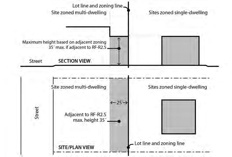
2. Step-down height. In the following situations, the base height is reduced, or steppeddown:
a. On the portion of a site within 25 feet of a lot line abutting a site zoned RF through R2.5, the step-down height is 35 feet. See Figure 120-2. Sites with property lines that abut a single-dwelling zone for less than a 5-foot length are exempt from this standard; and
b. On the portion of the site within 15 feet of a lot line that is across a local service street or alley from a site zoned RF through R2.5 the following step-down height limits apply. The limits do not apply to portions of buildings within 100 feet of a transit street.
(1) The step-down height is 45 feet for sites in the RM2, RM3, RM4, and RX zones.
(2) The step-down height is 35 feet for sites in the RM1 and RMP zones.
Step-Down Height Adjacent to Single-Dwelling Zones
C. Exceptions to the maximum height.
1. Chimneys, vents, flag poles, satellite receiving dishes, and other similar items, with a width, depth, or diameter of 5 feet or less may extend above the height limit, as long as they are attached to a building and do not exceed 5 feet above the top of the
Figure 120-2
highest point of the roof. If they are greater than 5 feet in width, depth, or diameter, they are subject to the height limit.
2. Parapets and railings. Parapets and rooftop railings may extend 4 feet above the height limits.
3. Walls and fences. Walls or fences located between individual rooftop decks may extend 6 feet above the height limit provided that the wall or fence is set back at least 4 feet from the edges of the roof.
4. Rooftop mechanical equipment and stairwell enclosures that provide rooftop access may extend above the height limit as follows, provided that the equipment and enclosures are set back at least 15 feet from all roof edges on street facing facades
a. Elevator mechanical equipment may extend up to 16 feet above the height limit; and
b. Other mechanical equipment and stairwell enclosures that cumulatively cover no more than 10 percent of the roof area may extend up to 10 feet above the height limit.
5. Antennas, utility power poles, and public safety facilities are exempt from the height limit.
6. Small wind turbines are subject to the standards of Chapter 33.299.
7. Roof mounted solar panels are not included in height calculations, and may exceed the maximum height limit as follows:
a. For flat roofs or the horizontal portion of mansard roofs, the roof mounted solar panel may extend up to 5 feet above the top of the highest point of the roof.
b. For pitched, hipped, or gambrel roofs, the roof mounted solar panel must be mounted no more than 12 inches from the surface of the roof at any point, and may not extend above the ridgeline of the roof. The 12 inches is measured from the upper side of the solar panel.
33.120.220
Setbacks
A. Purpose. The building setback regulations serve several purposes:
• They maintain light, air, separation for fire protection, and access for fire fighting;
• They reflect the general building scale and placement of multi-dwelling development in the City's neighborhoods;
• They promote a reasonable physical relationship between residences;
• They promote options for privacy for building residents and neighboring properties;
• They provide adequate flexibility to site a building so that it may be compatible with the neighborhood, fit the topography of the site, allow for required outdoor areas, and allow for architectural diversity;
• Setback requirements along transit streets create an environment that is inviting to pedestrians and transit users; and
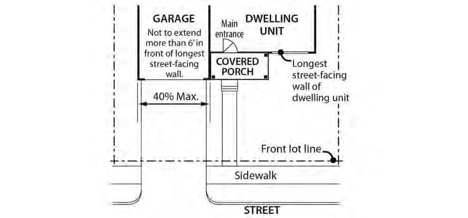
• They provide room for a car to park in front of a garage door without overhanging the street or sidewalk, and they enhance driver visibility when backing onto the street.
B. Minimum building setbacks. The required minimum building setbacks apply to all buildings and structures on the site except as specified in this section. Setbacks for parking areas are in Chapter 33.266.
1. Generally. The required minimum building setbacks, if any, are stated in Table 120-4. In the RM3 and RM4 zones, the minimum side and rear building setbacks apply as follows:
a. Buildings that are up to 55 feet tall. The required minimum side and rear building setback for buildings that are up to 55 feet tall is 5 feet. Minor projections allowed by Paragraph 33.120.215.C do not count toward this height measurement; and
b. Buildings more than 55 feet tall. The required minimum side and rear building setback for buildings that are more than 55 feet tall is 10 feet from a side or rear lot line that is not a street lot line, and 5 feet from a side or rear lot line that is a street lot line.
2. Eastern Pattern Area minimum rear building setback.
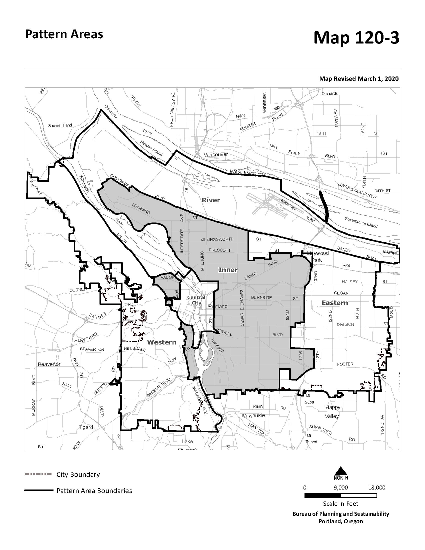
a. Minimum rear building setback. In the RM1, RM2, RM3 and RM4 zones in the Eastern Pattern Area the required minimum rear building setback is an amount equal to 25 percent of the total depth of the site. No more than 50 percent of the Eastern Pattern Area rear setback can be vehicle area. The Eastern Pattern Area is shown on Map 120-3.
b. Exemptions. The following are exempt from the Eastern Pattern Area minimum rear building setback. When a site is exempt from the Eastern Pattern Area minimum rear building setback, the base zone required minimum rear building setback stated in Table 120-4 applies:
(1) Corner lots and lots that are up to 100 feet deep are exempt from the Eastern Pattern Area minimum rear building setback; and
(2) Sites where at least 10 percent of the total site area is outdoor common area and the common areas measure at least 30 feet in all directions are exempt from the Eastern Pattern Area minimum rear setback.
(3) Cottage clusters allowed under section 33.120.270.G.
3. Exceptions to the required building setbacks.
a. Setback matching. The minimum front and side street building setbacks and the setback of decks, balconies, and porches may be reduced to match the setback on an abutting lot.
b. Raised ground floor. In the RM2 and RM3 zones the minimum front building setback may be reduced to 5 feet, and in the RM4 zone the minimum front and side street building setbacks may be reduced to zero feet, for buildings where the finished floor of ground floor residential units is between 2 feet and 5 feet
above the grade of the closest adjoining sidewalk. This exception does not apply in the Eastern Pattern Area shown on Map 120-3.
c. Courtyard. Except in the Eastern Pattern Area shown on Map 120-3, the required minimum front or side street setback may be reduced to zero in the RM2 and RM3 zones, and may be reduced to 5 feet in the RM1 zone when:
(1) At least 20 feet or 25 percent of the length of the street-facing building facade, whichever is greater, is setback at least 40 feet from the street lot line;
(2) At least half of the area between the setback portion of the building and the street lot line is landscaped to at least the L1 standard and the setback includes no vehicle area; and
(3) The finished floor of the ground floor is between 2 feet and 5 feet above the grade of the closest abutting sidewalk.
d. Ground floor commercial. The required minimum front or side street setbacks may be reduced to zero in the RM2, RM3 and RM4 zones when the ground floor includes a commercial use and at least 50 percent of the length of the groundfloor street-facing façade is in a commercial use or is an indoor common area, such as an indoor recreation facility or community room. This exception does not apply in the Eastern Pattern Area shown on Map 120-3.
e. Environmental zone. The required minimum front and street building setback and garage entrance setback may be reduced to zero where any portion of the site is in an environmental overlay zone. Where a side lot line is also a street lot line the side building and garage entrance setback may be reduced to zero. All other provisions of this Title apply to the building and garage entrance.
f. Split zoning. No setbacks are required from an internal lot line that is also a zoning line on sites with split zoning.
g. Alley. No side or rear building setback is required from a lot line abutting an alley.
h. Land divisions with existing development. When a dedication of public right-ofway along the frontage of an existing street is required as part of a land division, the minimum front or side setback between an existing building and a lot line that abuts the right-of-way may be reduced to zero. Eaves on an existing building may extend one foot into the reduced setback, except that they may not extend into the right-of-way. Future additions or development must meet required minimum setbacks.
i. Eastern Pattern Area. In the Eastern Pattern Area, the footprint of buildings containing only indoor common area, such as recreational facilities or tenant community rooms, may cover up to 25 percent of the Eastern Pattern Area minimum rear building setback. In this case, the building must be set back at least 5 feet from the rear lot line.
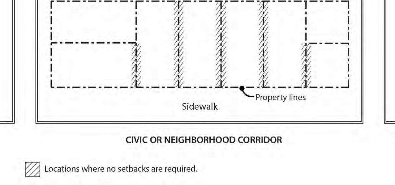
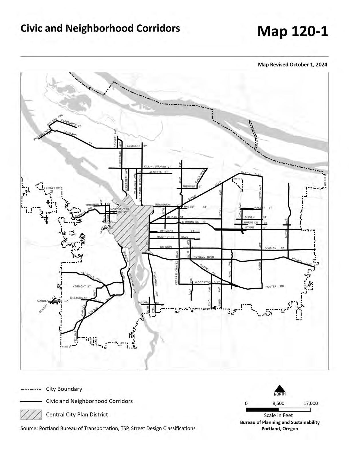
j. Inner Pattern Area. In the RM2, RM3, and RM4 zones in the Inner Pattern Area, on sites that abut a Civic or Neighborhood Corridor shown on Map 120-1, no setback is required from a lot line that abuts a property that also has a lot line on a Civic or Neighborhood Corridor. See Figure 120-3. However, windows in the walls of dwelling units must be setback a minimum of 5 feet from a lot line that abuts another property and this setback area must be a minimum width of 12 feet or the width of the residential window, whichever is greater.
Figure 120-3
No setbacks between properties on Civic or Neighborhood Corridors
C. Maximum building setbacks.
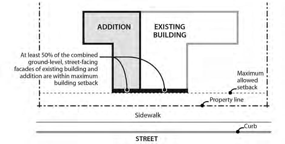
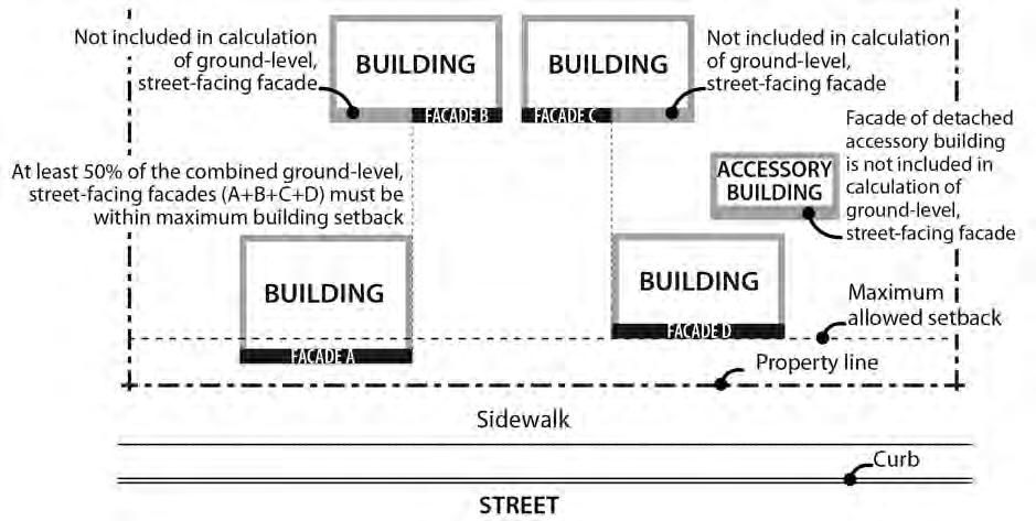
1. Maximum building setbacks on a transit street or in a Pedestrian District. The required maximum building setbacks, if any, are stated in Table 120-4, and apply only to buildings that are enclosed on all sides. The maximum building setbacks on a transit street or in a Pedestrian District are as follows At least 50 percent of the length of the ground level street-facing façade of the building must meet the maximum building setback standard:
a. Applying the standard
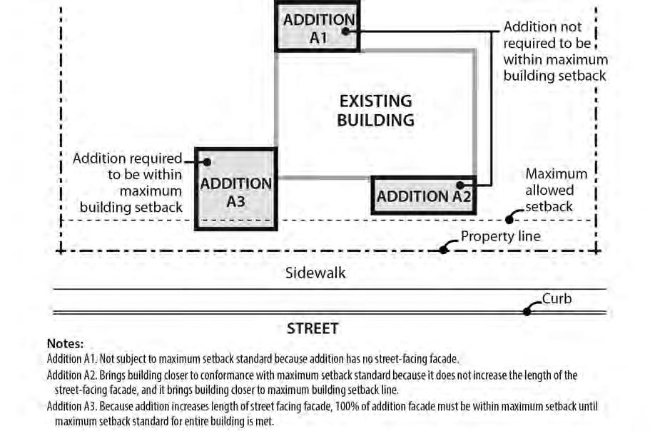
(1) Where an existing building is being altered, the standards apply to the ground level, street-facing facade of the entire building. See Figures 120-4 and 120-5.
(2) Where there is more than one building on the site, the standards of this paragraph apply to the combined ground level, street-facing facades of all the buildings. See Figures 120-6 and 120-7.
(3) For buildings where all of the floor area is in residential use, the streetfacing facade of an open porch that meets the following standards is included as part of the ground level, street-facing facade of the building:
• For houses, attached houses, manufactured homes and duplexes, the porch must be at least 25 square feet in area. For multi-dwelling structures, the porch must be at least 9 feet wide and 7 feet deep;
• The porch must have at least one entrance facing the street; and
• The porch must have a roof that is:
No more than 12 feet above the floor of the porch; and
At least 30 percent solid. This standard may be met by having 30 percent of the porch area covered with a solid roof, or by having the entire area covered with a trellis or other open material if no more than 70 percent of the area of the material is open.
b. Outside a Pedestrian District. Where the site is not in a Pedestrian District:
(1) One transit street. Where the site is adjacent to one transit street, the standard must be met on the transit street frontage;
(2) Two non-intersecting transit streets. Where the site is adjacent to two transit streets that do not intersect:
• The standard must be met on the frontage of the street with the highest transit classification. If both streets have the same highest classification, the applicant may choose on which street to meet the standard;
• If one of the transit streets intersects a City Walkway, the standard must be met along both the street with the highest transit classification and the City Walkway;
(3) Two or more intersecting transit streets. Where the site is adjacent to two or more intersecting transit streets, the standard must be met on the frontages of the two streets with the highest transit classifications. If more than two streets have the same highest transit classification, the applicant may choose on which two streets to meet the standard;
c. In a Pedestrian District. Where the site is in a Pedestrian District, the maximum building setback standard applies to all street frontages, with the following exceptions:
(1) Through lots. If the site is a through lot, the maximum setback standard only applies to the street with the highest transit street classification. If multiple streets have the same highest transit street classification, the applicant may choose on which street to apply the standard.
(2) Three or more street frontages. If the site has street lot lines on three or more streets, the maximum setback standard only applies to two of the streets. When this occurs, the standard must be applied to the streets with the highest transit street classifications. If multiple streets have the same highest transit street classification, the applicant may choose on which streets to apply the standard.
Title 33, Planning and Zoning
Figure 120-4
Alteration to Existing Building in Conformance with Maximum Setback Standard
Figure 120-5
Alterations to Existing Building
Figure 120-6
Calculating Maximum Building Setback When More Than One Building On Site
Figure 120-7
New Buildings On Sites With Buildings That Do Not Meet The Maximum Building Setback
2. Exemptions.
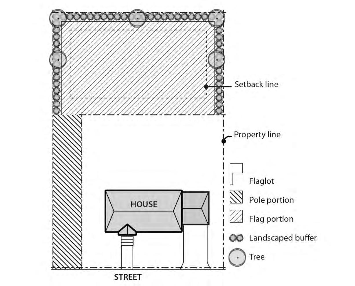
a. Flag lots. Flag lots are exempt from the maximum setback standards of this section.
b. Detached accessory structures. Detached accessory structures are exempt from the maximum setback standards of this section. The street-facing facades of detached accessory structures do not count towards meeting maximum setback standards. See Figure 120-6.
D. Extensions into required building setbacks.
1. The following features of a building may extend into a required building setback up to 20 percent of the depth of the setback, except as indicated. However, the feature must be at least 3 feet from a lot line, except as allowed in 33.120.270, Alternative Development Options:
a. Chimneys, fireplace inserts and vents, mechanical equipment, and fire escapes;
b. Wheelchair ramps, water collection cisterns and stormwater planters that do not meet the standards of Paragraph D.4;
c. Decks, stairways, and uncovered balconies that do not meet the standard for Paragraph D.4, but only along a street lot line; and
d. Bays and bay windows but only along a street lot line and must meet the following requirements:
(1) Each bay and bay window may be up to 12 feet long, but the total area of all bays and bay windows on a building facade cannot be more than 30 percent of the area of the facade;
(2) At least 30 percent of the area of the bay which faces the property line requiring the setback must be glazing or glass block; and
(3) Bays and bay windows must cantilever beyond the foundation of the building.
2. Building eaves may project up to 2 feet into a required setback, provided the eave is at least 3 feet from a lot line.
3. Canopies and awnings may extend up to 5 feet into a required setback along a street lot line.
4. The following minor features may extend into entire required building setbacks:
a. Utility connections attached to the building that are required to provide services, such as water electricity and other similar utility services;
b. Gutters and downspouts that drain stormwater off a roof of the structure;
c. Stormwater planters that are no more than 2-1/2 feet above the ground;
d. Water collection cisterns that are 6 feet or less in height;
e. Attached decks, stairs, and ramps that are no more than 2-1/2 feet above the ground. However, stairways and wheelchair ramps that lead to one entrance on the street-facing facade of a building are allowed to extend into the required street setbacks regardless of height above ground; and
f. On lots that slope down from the street, vehicular or pedestrian entry bridges that are no more than 2-1/2 feet above the average sidewalk elevation.
5. Detached accessory structures. The setback standards for detached accessory structures including detached mechanical equipment are stated in 33.120.280 below. Fences are addressed in 33.120.285, below. Detached accessory dwelling units are addressed in Chapter 33.205.
E. Garage entrance and structured parking setback.
1. Garage entrance setback. The garage entrance setback is stated in Table 120-4. See Chapter 33.910, Definitions, for a description. The walls of the garage structure are subject to 33.120.283 and the applicable front, side, or rear building setbacks.
a. In the RM2, RM3, RM4, and RX zone, the garage entrance must be either 5 feet or closer to the street lot line, or 18 feet or farther from the street lot line. If the garage entrance is located within 5 feet of the front lot line, it may not be closer to the lot line than the facade of the residential portion of the building.
b. Exceptions. No setback is required from a lot line abutting an alley. However, the Bureau of Transportation may require the garage entrance to be set back to ensure adequate turning radius into the garage.
2. Setbacks for structured parking. Structured parking that allows exiting in a forward motion is subject to the setback requirements for buildings. Structured parking that does not allow exiting in a forward motion is subject to the garage entrance setback standard stated in Table 120-4.
33.120.225 Building Coverage
A. Purpose. The building coverage standards, along with the height and setback standards, limit the overall bulk of structures. They assure that larger buildings will not have a footprint that overwhelms adjacent development. The standards help define the character of the different zones by determining how built-up a neighborhood appears.
B. Maximum building coverage. The maximum building coverages for all covered structures on the site are stated in Table 120-4. In the RM2 zone, maximum building coverage on sites that abut a Civic Corridor or Neighborhood Corridor shown on Map 120-1 is 70 percent of site area. Maximum building coverage on all other RM2 sites is 60 percent of site area.
C. Exception. Structured parking that is no more than 6 feet above grade at any point, except as indicated below, does not count toward building coverage if the structured parking does not have floor area above it, and the structured parking is covered by landscaping or an outdoor common area. Vehicle or pedestrian access into the structured parking is exempt from the calculation of grade, if the access is no more than 20 feet wide.
33.120.230
Building Length and Façade Articulation
A. Purpose. These standards, along with the height and setback standard, limit the bulk of buildings close to the street. These standards help ensure that large buildings will be divided into smaller components that relate to the scale and development patterns of Portland’s multi-dwelling residential areas and add visual interest and variety to the street environment.
B. Maximum building length. In the RM1, RM2, and RMP zones, the maximum building length for the portion of buildings located within 30 feet of a street lot line is 100 feet. The portions of buildings subject to this standard must be separated by a minimum of 10 feet. See Figure 120-8. Manufactured dwelling parks are exempt from this standard.
Figure 120-8
Maximum Building Length
C. Facade articulation
1. Where the standard applies. This standard applies in the RM2 through RM4 zones as follows. Development that includes a residential use is exempt from this standard until January 1, 2029:
a. In the RM2 zone, the standard applies to buildings more than 35 feet high that have facade areas of more than 3,500 square feet within 20 feet of a street property line.
b. In the RM3 and RM4 zones, the standard applies to buildings more than 45 feet high that have facade areas of more than 4,500 square feet within 20 feet of a street property line.
c. Portions of building facades that are vertically separated by a gap of at least 10 feet in width extending at least 30 feet in depth from the street property line are
considered to be separate facades areas for the purposes of the facade area measurements. See Figure 120-8.
2. The standard. At least 25 percent of the area of a street-facing facade within 20 feet of a street lot line must be divided into facade planes that are off-set by at least 2 feet in depth from the rest of the facade. Facade area used to meet the facade articulation standard may be recessed behind, or project out from, the primary facade plane, but projections into street right-of-way, and balconies that do not count toward floor area do not count toward meeting this standard. See Figure 120-9.
Figure 120-9 Facade Articulation
33.120.231 Main Entrances
A. Purpose. The main entrance standards:
• Together with the window and garage standards, ensure that there is a physical and visual connection between the living area of the residence and the street;
• Enhance public safety for residents and visitors and provide opportunities for community interaction;
• Ensure that the pedestrian entrance is visible or clearly identifiable from the street by its orientation or articulation; and
• Ensure a connection to the public realm for development on lots fronting both private and public streets by making the pedestrian entrance visible or clearly identifiable from the public street.
B. Where these standards apply.
1. The standards of this section apply to all residential structure types in the multidwelling zones except for accessory dwelling units, manufactured dwelling parks, and houseboat moorages. For multi-dwelling development, the standards apply only to residential structures that are located within 40 feet of a street lot line.
2. Where a proposal is for an alteration or addition to existing development, the standards apply only to the portion being altered or added.
3. On sites with frontage on both a private street and a public street, the standards apply to the site frontage on the public street. On all other sites with more than one street frontage, the standards apply to the transit street. If there is no transit street, the applicant may choose on which frontage to meet the standards. If there is more than
one transit street, the standards apply to the street with the highest transit street classification. If all streets have the same transit street classification, the applicant may choose on which frontage to meet the standards.
4. Development on flag lots or on lots that slope up or down from the street with an average slope of 20 percent or more are exempt from these standards.
5. Subdivisions and PUDs that received preliminary plan approval between September 9, 1990, and September 9, 1995, are exempt from this standard.
6. Development on lots where any portion of the lot is in a combined flood hazard area is exempt from the standard in Subsection D.
C. Main entrance.
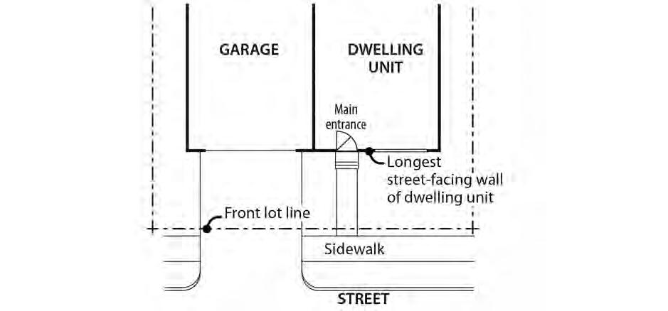
1. Standard. At least one main entrance for each structure must:
a. Be within 8 feet of the longest street-facing wall of the structure; and
b. Either:
(1) Face the street. See Figure 120-10;
(2) Be at an angle of up to 45 degrees from the street; or
(3) Open onto a porch. See Figure 120-11. The porch must:
• Be at least 25 square feet in area;
• Have at least one entrance facing the street; and
• Have a roof that is:
No more than 12 feet above the floor of the porch; and
At least 30 percent solid. This standard may be met by having 30 percent of the porch area covered with a solid roof, or by having the entire area covered with a trellis or other open material if no more than 70 percent of the area of the material is open.
2. Alternative for multi-dwelling structures. As an alternative to Paragraph C.1, an entrance to a multi-dwelling structure may face a courtyard if the courtyard-facing entrance is located within 60 feet of a street and the courtyard meets the following standards:
a. The courtyard must be at least 15 feet in width;
b. The courtyard must abut a street; and
c. The courtyard must be landscaped to at least the L1 level, or hard-surfaced for use by pedestrians.
D. Distance from grade. For houses, attached houses, manufactured homes, duplexes, triplexes, and fourplexes, the main entrance that meets Paragraph C.1 must be within 4 feet of grade. For the purposes of this Subsection, grade is the average grade measured at the outer most corners of the street facing facade. See Figure 120-12.
Chapter 33.120 Title 33, Planning and Zoning
Figure 120-10
Main Entrance Facing the Street
Figure 120-11
Main Entrance Opening Onto a Porch
Figure 120-12
Calculation of Grade: (Elevation A + Elevation B) / 2
33.120.232 Street-Facing Facades
A. Purpose. The standards:
• Work with the main entrance and garage standards to ensure that there is a visual connection between the living area of the residence and the street;
• Enhance public safety by allowing people to survey their neighborhood from inside their residences; and
• Provide a pleasant pedestrian environment by preventing large expanses of blank facades along streets.
B. Where these standards apply.
1. The standards of this section apply to the street-facing facades of all residential structure types except for accessory dwelling units, manufactured dwelling parks, and houseboat moorages. The standards of this section also do not apply in the RMP zone.
2. Where a proposal is for an alteration or addition to existing development, the applicant may choose to apply the standard either to the portion being altered or added, or to the entire street-facing facade. For a residential building with up to 4 units, the side wall of a dormer is exempt from this standard.
3. Development on flag lots, and development on lots that slope up or down from the street with an average slope of 20 percent or more, is exempt from these standards.
4. Subdivisions and PUDs that received preliminary plan approval between September 9, 1990, and September 9, 1995, are exempt from Subsection C.
5. For structures subject to ground floor window standard in Subsection D, windows used to meet the ground floor window standard may also be used to meet the requirements of Subsection C.
C. Windows. At least 15 percent of the area of each facade that faces a street lot line must be windows or main entrance doors. Windows used to meet this standard must allow views from the building to the street. Glass block does not meet this standard. Windows in garage doors do not count toward meeting this standard, but windows in garage walls do count toward meeting this standard. To count toward meeting this standard a door must be at the main entrance and facing the street property line. Development on flag lots or on lots which slope up or down from the street with an average slope of 20 percent or more are exempt from these standards.
D. Ground floor windows. The following ground floor window standards apply to the portion of a building with ground floor commercial uses. For the purposes of this Paragraph, ground floor wall area includes exterior wall area from 2 feet to 10 feet above the finished grade. Required ground floor windows must be windows in walls or entrances that allow views into working area or display windows that are at least 24 inches deep set into a wall. The bottom of qualifying windows must be no more than 4 feet above the adjacent exterior grade:
1. Windows must cover at least 40 percent of the ground floor wall area of the portion of a building that has a ground floor commercial use when the ground floor wall is located closer than 5 feet from a street lot line.
2. Windows must cover at least 25 percent of the ground floor wall area of the portion of building that has a ground floor commercial use when the ground floor wall is located 5 feet or more from a street lot line.
33.120.235
Landscaped Areas
A. Purpose. The standards for landscaped areas are intended to enhance the overall appearance of residential developments and institutional campuses in multi-dwelling zones. The landscaping improves the residential character of the area, breaks up large expanses of paved areas and structures, provides privacy to the residents, and provides separation from streets. Landscaping also helps cool the air temperature, intercept rainfall and reduce stormwater run-off by providing a non-paved permeable surface. Landscaping can also provide food for people and habitat for birds and other wildlife.
B. Minimum landscaped areas. The required amount of landscaped area is stated in Table 120-4. Sites developed with a house, attached house, duplex, or manufactured dwelling park are exempt from this standard. Any required landscaping, such as for required setbacks or parking lots, applies toward the minimum required landscaped area.
1. Except as allowed by Paragraph B.2., required landscaped areas must:
a. Be at ground level or in raised planters that are used to meet minimum Bureau of Environmental Services stormwater management requirements; and
b. Comply with at least the L1 standard described in Chapter 33.248, Landscaping and Screening. However, up to one-third of the required landscaped area may be improved for active or passive recreational use or for use by pedestrians. Examples of active or passive recreational use include walkways, play areas, plazas, picnic areas, garden plots, and unenclosed recreational facilities.
2. Urban green alternative landscaped area. One or more of the following may be used to meet up to 50 percent of the required landscaped area:
a. Ecoroof. An ecoroof area may apply toward meeting the required landscaped area standard at a ratio of 4 square feet of ecoroof area for every 1 square foot of required landscaped area. The ecoroof area must be approved by the Bureau of Environmental Services as being in compliance with the Stormwater Management Manual.
b. Raised landscaped areas. Landscaped area raised above ground level may apply toward meeting the minimum landscaped area standard when landscaped to at least the L1 standard and soil depth is a minimum of 30 inches. Large trees are not allowed in raised landscaped area used to meet this alternative.
C. Additional landscaping standards.
1. Building setbacks. The required building setbacks must be landscaped to at least the L1 standard of Chapter 33.248, Landscaping and Screening. Ground-level pedestrian pathways, detached accessory structures and other development allowed in the setbacks are exempt from this standard except in the Eastern Pattern Area where allowed development can cover no more than 50 percent of the Eastern Pattern Area minimum rear setback area. Sites that are 10,000 square feet or less in total site area are also exempt from this standard.
2. Parking areas. Perimeter and internal parking area landscaping standards are stated in Chapter 33.266, Parking, Loading, and Transportation and Parking Demand Management
33.120.237 Trees
Requirements for street trees and for on-site tree preservation, protection, and overall tree density are specified in Title 11, Trees. See Chapter 11.50, Trees in Development Situations.
33.120.240 Required Outdoor and Common Areas
A. Purpose. The required outdoor and common area standards ensure opportunities for outdoor relaxation or recreation. The standards work with the building coverage and minimum landscaped areas standards to ensure that some of the land not covered by buildings is of adequate size, shape, and location to be usable for outdoor recreation or relaxation. The standards also ensure that outdoor areas are located so that residents have convenient access. Required outdoor areas are an important aspect in addressing the livability of a residential property by providing outdoor living opportunities, some options for outdoor privacy, and a healthy environment. These standards also allow for common area requirements to be met by indoor community facilities because they also provide opportunities for recreation and gathering.
B. Outdoor area and common area requirements. In the RM1 through RM4 zones, on sites with a residential use, both outdoor and common areas are required. Required common area may count toward required outdoor area, but individual private outdoor area may not count toward required common area. The standards of this section do not apply in the RX and RMP zones.
1. Required outdoor area. Outdoor area is required in the amounts stated below. Outdoor area may be provided as individual private outdoor area, such as a patio or balcony, or may be provided as common area, such as outdoor courtyards, outdoor play area, indoor recreational facilities, or indoor community rooms. There may be a combination of individual or common areas.
a. RM1 and RM2 zones. In the RM1 and RM2 zones, at least 48 square feet of outdoor area is required per dwelling unit.
b. RM3 and RM4 zones. In the RM3 and RM4 zones, on sites that are 20,000 square feet or less in total area, at least 36 square feet of outdoor area is required per dwelling unit. In the RM3 and RM4 zones, on sites that are more than 20,000 square feet in total area, at least 48 square feet of outdoor area is required per dwelling unit.
2. Required common area.
a. Required common area standard. On sites that are more than 20,000 square feet in total site area, and on sites with a congregate housing facility, at least 10 percent of total site area must be provided as common area. At least 50 percent of the required common area must be outdoor area, such as outdoor courtyards or outdoor play areas. Up to 50 percent of the required common area may be indoor common area, such as indoor recreation facilities or indoor community rooms.
b. Exemption. The required common area standard does not apply to sites where:
(1) All of the dwelling units have individual entrances that are within 20 feet of a street lot line;
(2) Each entrance is connected to the street by a path that is at least 3 feet wide and hard surfaced; and
(3) Each dwelling unit has at least 200 square feet of individual outdoor area with a minimum dimension of 10 feet by 10 feet.
C. Size, location and configuration.
1. Individual unit outdoor area. Where a separate outdoor area is provided for an individual unit, it must be designed so that a 4-foot x 6-foot square will fit entirely within it. The outdoor area must be directly accessible to the unit. Areas used for pedestrian circulation to more than one dwelling unit do not count towards meeting this standard of this subsection. If the area is at ground level, it may extend into the entire required side and rear setback. Individual unit outdoor areas located at ground level may also extend into the entire required street setback, but when located within a required street setback the outdoor area must either be at least 2 feet above the grade of the closest adjoining sidewalk or separated from the street lot line by a minimum 3 foot setback landscaped to at least the L2 standard described in Chapter 33.248, Landscaping and Screening. Covered outdoor areas are subject to Paragraph C.5 below.
2. Common areas.
a. Outdoor common area. Where an outdoor, shared common area is provided, it must be designed so that it is at least 500 square feet in area and must measure at least 20 feet in all directions. The outdoor common area must be located within 20 feet of a building entrance providing access to residential units
b. Indoor common area. Where an indoor common area is provided, it must be an indoor recreational facility or an indoor tenant community room. Indoor common areas that are not recreational facilities or community rooms, such as lobbies, hallways, laundry facilities, storage rooms, and vehicle or bicycle facilities, cannot be used to meet this requirement.
c. Combination of individual and common areas. Where a combination of individual unit and common areas is provided, each individual area must meet C.1 above and each common area must meet C.2.a or C.2.b above, providing an amount equivalent to the total required by Paragraph B.1 or B.2
3. Surfacing materials. Required outdoor areas must be surfaced with lawn, pavers, decking, or sport court paving which allows the area to be used for active or passive recreational use.
4. User amenities. User amenities, such as tables, benches, trees, shrubs, planter boxes, garden plots, drinking fountains, spas, or pools, may be placed in the outdoor area. Common, shared outdoor areas may also be developed with amenities such as play areas, plazas, roof-top patios, picnic areas, and open recreational facilities.
5. Enclosure. Outdoor areas used to meet the requirements of this section may be covered, such as a covered patio, but they may not be fully enclosed. Covered outdoor areas are subject to the setback standards of this chapter.
33.120.250
Screening
A. Purpose. The screening standards address specific unsightly features which detract from the appearance of multi-dwelling residential areas.
B. Garbage and recycling collection areas. All exterior garbage cans, garbage collection areas, and recycling collection areas must be screened from the street and any adjacent properties. Trash receptacles for pedestrian use are exempt. Screening must comply with at least the L3 or F2 standards of Chapter 33.248, Landscaping and Screening.
C. Mechanical equipment. Mechanical equipment located on the ground, such as heating or cooling equipment, pumps, or generators must be screened from the street and any abutting residential zones by walls, fences, or vegetation. Screening must comply with at least the L2 or F2 standards of Chapter 33.248, Landscaping and Screening, and be tall enough to screen the equipment. Mechanical equipment placed on roofs must be screened in one of the following ways, if the equipment is within 50 feet of an R zone:
1. A parapet along facades facing the R zone that is as tall as the tallest part of the equipment;
2. A screen around the equipment that is as tall as the tallest part of the equipment; or
3. The equipment is set back from roof edges facing the R zone 3 feet for each foot of height of the equipment.
D. Other screening requirements. Outdoor seating associated with a Retail Sales And Service use must be screened from any abutting residential zones by walls, fences or vegetation. Screening must comply with at least the L3 or F2 standards of Chapter 33.248, Landscaping and Screening. The screening requirements for parking, exterior storage, and exterior display areas are stated with the regulations for those types of development.
33.120.255 Pedestrian Standards
A. Purpose. The pedestrian standards encourage a safe, attractive, and usable pedestrian circulation system in all developments. They ensure a direct pedestrian connection between abutting streets and buildings on the site, and between buildings and other activities within the site. In addition, they provide for connections between adjacent sites, where feasible. The standards promote configurations that minimize conflicts between pedestrians and vehicles. In order to facilitate additional pedestrian oriented space and less impervious surface, the standards also provide opportunities for accessways with low traffic volumes, serving a limited number of residential units, to be designed to accommodate pedestrians and vehicles within the same space when special paving treatments are used to signify their intended use by pedestrians as well as vehicles.
B. The standards. The standards of this section apply to all development except houses, attached houses, manufactured homes on individual lots, duplexes, and attached duplexes. The standards of this section also do not apply to manufactured dwelling parks. An on-site pedestrian circulation system must be provided. The system must meet all standards of this subsection.
1. Connections. The on-site pedestrian circulation system must provide connections as specified below:
a. Connection between streets and entrances.
(1) Sites with one street frontage.
• Generally. All primary buildings located within 40 feet of a street lot line must have a connection between one main entrance and the adjacent street. The connection may not be more than 20 feet longer or 120 percent of the straight line distance, whichever is less.
• Tree preservation. If a tree that is at least 12 inches in diameter is proposed for preservation, and the location of the tree or its root protection zone would prevent the standard of this paragraph from being met, the connection may be up to 200 percent of the straight line distance.
(2) Sites with more than one street frontage. Where the site has more than one street frontage, the following must be met:
• The standard of B.1.a(1) must be met to connect the main entrance of each building located within 40 feet of a street lot line to the closest sidewalk or roadway if there are no sidewalks.
• An additional connection, which does not have to be a straight line connection, is required between each of the other streets and a
pedestrian entrance. However, if at least 50 percent of a street facing facade is within 10 feet of the street, no connection is required to that street.
b. Internal connections. On sites larger than 10,000 square feet, an internal pedestrian connection system must be provided. The system must connect all main entrances on the site that are more than 20 feet from the street, and provide connections to other areas of the site, such as parking areas, bicycle parking, recreational areas, common outdoor areas, and any pedestrian amenities.
2. Materials.
a. The circulation system required by the standards of this section must be hardsurfaced and must meet the following minimum width requirements:
(1) The circulation system on sites with up to 4 residential units must be at least 3 feet wide.
(2) The circulation system on sites with 5 to 20 units must be at least 4 feet wide.
(3) The circulation system on sites with more than 20 residential units must be at least 5 feet wide.
(4) Segments of the circulation system that connect only to an entrance providing access to up to 4 units may be 3 feet wide.
b. Except as allowed in subparagraph d, below, where the system crosses driveways, parking areas, and loading areas, the system must be clearly identifiable, through the use of elevation changes, speed bumps, a different paving material, or other similar method. Striping does not meet this requirement. Elevation changes and speed bumps must be at least 4 inches high.
c. Except as allowed in subparagraph d, below, where the system is parallel and adjacent to an auto travel lane, the system must be a raised path or be separated from the auto travel lane by a raised curb, bollards, landscaping or other physical barrier. If a raised path is used it must be at least 4 inches high and the ends of the raised portions must be equipped with curb ramps. Bollard spacing must be no further apart than 5 feet on center.
d. The pedestrian circulation system may be within an auto travel lane if the auto travel lane provides access to 16 or fewer parking spaces and the entire auto travel lane is surfaced with paving blocks or bricks.
3. Lighting. The on-site pedestrian circulation system must be lighted to a level where the system can be used at night by the employees, residents, and customers.
33.120.260 Recycling Areas
Requirements for recycling areas are regulated by the Bureau of Planning and Sustainability. See Section 17.102.270, Businesses and Multifamily Complexes Required to Recycle, of the Portland City Code.
33.120.270
Alternative Development Options
A. Purpose. The alternative development options provide increased variety in development while maintaining the residential neighborhood character. The options are intended to:
• Accommodate a diversity of housing types and tenures;
• Encourage development which is more sensitive to the environment, especially in hilly areas;
• Encourage the preservation of open and natural areas;
• Promote better site layout and adequate opportunities for private or common recreation and open areas;
• They promote a visual connection between the residences and the common open areas;
• Allow for greater flexibility within a development site while limiting impacts to the surrounding neighborhood;
• Promote more opportunities for affordable housing;
• Allow more energy-efficient development; and
• Reduce the impact that new development may have on surrounding residential development.
B. General requirements for all alternative development options. The alternative development options listed in this section are allowed by right unless it is specifically stated otherwise. They must conform with all other development standards of the base zone unless those standards are superseded by the ones in this section. Sites in the RMP zone are not eligible for alternative development option.
C. Attached houses. The development standards for attached housing are:
1. Density, height, and other development standards. The minimum density, height, building length, landscaped areas, required outdoor area, and window requirements of the base zone apply.
2. Lot size. See 33.612, Lots in Multi-Dwelling Zones, for lot size information.
3. Building setbacks. The side building setback on the side containing the common or abutting wall is reduced to zero. The reduced setback applies to all buildings on the lot and extends along the full length of the lot line that contains the common or abutting wall.
4. Building coverage. The maximum building coverage of the base zone applies to the entire attached housing project, however the maximum building coverage for an individual lot may not exceed 5 percent more than the base zone allowance.
5. Maximum building length. The maximum building length standard stated in Table 1204 applies to the combined length of the street-facing facades of each unit.
D. Reduced setbacks for detached houses. For land divisions that include lots created for detached houses, where the lots are at least 25 feet wide, the detached houses may have their side setbacks reduced to 3 feet on lot lines internal to the land division site. The reduced side setbacks must be shown on the land division Preliminary Plan Eaves may
project up to one foot into the reduced side setback. All building setbacks around the perimeter of the land division site are those of the base zone.
E. Attached duplexes. The attached duplex regulations allow for an alternative housing type that promotes owner-occupied structures, the efficient use of land, and for energyconserving housing.
1. Lot size. Each attached duplex must be on a lot that complies with the lot size standard for new lots of the base zone.
2. Building setbacks. The side building setback on the side containing the common wall is reduced to zero.
3. Number of units. A maximum of 2 units per lot and 4 units per structure is allowed.
F. Cottage cluster. Cottage clusters that meet the following standards are allowed in the RM1 zone. Cottage clusters are prohibited on sites that do not have frontage on a maintained street, except sites that have frontage on a private street that connects to a maintained street, and sites that have frontage on a self-contained pedestrian connection created solely for pedestrians and bicycles that connects to a maintained street. Payment in lieu of street improvements does not satisfy this requirement. Except as allowed below, adjustments to the following standards are prohibited.
1. Minimum site dimensions. Adjustments to reduce the minimum required site dimensions by up to 10 percent may be requested prior to January 2, 2032. Beginning January 2, 2032, adjustments are prohibited.
a. Minimum site area. Cottages cluster sites must be at least 5,000 square feet in area.
b. Minimum site width. Cottage cluster sites must be at least 36 feet wide. Site width for a cottage cluster is measured as lot width is measured. See 33.930.100.
2. Maximum area. Cottage cluster sites must not be greater than 40,000 square feet. Adjustments to increase the area by up to 10 percent above this standard may be requested prior to January 2, 2032, if an adjustment to the maximum number of dwelling units is also requested. Beginning January 2, 2032, adjustments are prohibited.
3. Maximum dwelling units. The maximum number of dwelling units allowed on a cottage cluster site is 16. Adjustments to this standard may be requested prior to January 2, 2032. Beginning January 2, 2032, adjustments are prohibited.
4. Floor area. Cottage clusters are exempt from 33.120.210, Floor Area Ratio. However, the maximum average floor area for all dwelling units on the cottage cluster site is 1,400 square feet, including the floor area for attached accessory structures. The applicant may choose to exclude the floor area of any existing dwelling units that received final inspection at least 5 years ago from the average. The maximum floor area allowed for a detached accessory structure is 400 square feet.
5. Maximum height. The maximum height allowed is 25 feet. Existing dwelling units that that received final inspection at least 5 years ago exceed this maximum height are
allowed but the height cannot be increased. The maximum height standards for detached accessory structures are stated in 33.120.280, Detached Accessory Structures.
6. Separation. Dwelling units within the cottage cluster site must be separated by 6 feet.
7. Building coverage. Cottage clusters are exempt from 33.120.225. Building Coverage. The following building coverage standards apply:
a. The maximum building coverage allowed for each dwelling unit is 900 square feet and includes attached accessory structures. Existing dwelling units that received final inspection at least 5 years ago that exceed this limit are allowed but the building coverage cannot be increased; and
b. The building coverage of a detached covered accessory structure may not be greater than the building coverage of the smallest primary structure.
8. Common outdoor area. The following common outdoor area standards apply to cottage clusters. Cottage clusters are exempt from 33.120.240:
a. The total amount of common outdoor area required is 150 square feet per dwelling unit if all the dwelling units are separated by at least 10 feet or 200 square feet per dwelling unit if any of the dwelling units are separated by less than 10 feet. Adjustments to reduce the total required amount of common outdoor area by up to 25 percent may be requested prior to January 2, 2032. Beginning January 2, 2032, adjustments are prohibited.
b. Each common outdoor area:
(1) Must be at least 450 square feet in area. Required pedestrian connections located adjacent to or within a common outdoor area count toward this minimum size;
(2) Must measure at least 15 feet in all directions. Required pedestrian connections located adjacent to or within a common outdoor are included in this minimum width; and
(3) Must be located outside the required front setback.
c. Each required common outdoor area must be surfaced with landscaping, pavers, decking, or sport court paving to allow the shared area to be used for active or passive recreational use. No more than 50 percent of the total common outdoor area can be in an impervious surface. Common outdoor area may not be used as vehicle area. No feature of a dwelling unit may extend into the common outdoor area, and the common outdoor area may not contain structures that are not specifically an amenity for the user of the common outdoor area including bike storage lockers and trash enclosures.
d. User amenities. User amenities, such as tables, benches, trees, shrubs, planter boxes, garden plots, drinking fountains, spas, or pools, Common, shared outdoor areas may also be developed with amenities such as play areas, plazas, picnic areas, and open recreational facilities.
9. Dwelling unit orientation. Dwelling units located within 25 feet of a street property line must meet the base zone main entrance standards of 33.120.231, Main Entrances. All other dwellings units are exempt from 33.120.231 but must meet the following dwelling unit orientation standards. Adjustments to the following standards may be requested prior to January 2, 2032. Beginning January 2, 2032, adjustments are prohibited:
a. At least 50 percent of the dwelling units that are exempt from 33.120.231 must:
(1) Have at least one main entrance facing a common outdoor area; and
(2) Be located within 10 feet of the common outdoor area, measured from the closest point of the facade with the main entrance to the nearest edge of the common outdoor area.
b. Dwelling units that do not have a main entrance facing the common outdoor area or street must have at least one main entrance facing a pedestrian connection that is connected to the common outdoor area.
10. Windows. Cottage clusters are exempt from 33.120.232.C. However, 15 percent of the area of the façade with the required main entrance must be windows or main entrance doors. Adjustments to this standard may be requested prior to January 2, 2032, however adjustments to reduce the percentage required below 12 percent are prohibited. Beginning January 2, 2032, all adjustments are prohibited. Windows used to meet this standard must allow views from the building to the street, pedestrian connection, or common outdoor area. Glass block does not meet this standard. Windows in garage doors do not count toward meeting this standard, but windows in garage walls do count toward meeting this standard.
11. Visitability.
a. Purpose. The visitability standard ensures that a baseline of accessible features is provided to accommodate people living in or visiting the residence regardless of age or ability. The standards:
• Promote a diverse supply of more physically accessible housing;
• Allow people of all ages and abilities to easily enter and visit the residence;
• Foster community interaction by reducing barriers that can lead to social isolation; and
• Enhance public safety for all residents and visitors.
b. Visitable unit standard. Unless exempted by Subparagraph G.11.c., at least 33 percent of the dwelling units on the cottage cluster site must meet all of the following visitability standards:
(1) Visitable entrance. At least one entrance must be accessible via a route that does not have any stairs between it and the street lot line or an on-site parking space. The slope of the route may not exceed 1:8.
(2) Visitable bathroom. At least one bathroom with a sink and toilet must be designed to accommodate an unobstructed circle that is at least 60-inches in diameter. As an alternative, the bathroom may be designed to
accommodate an unobstructed area that is comprised of two rectangles that are at least 36 inches by 60 inches, and oriented at right angles to each other. See Figure 120-1. The visitable bathroom must be on the same floor as the visitable entrance or be accessible from the visitable entrance via a ramp, elevator or lift;
(3) Visitable living area. There must be at least 200 square feet of living area on the same floor as the visitable entrance or 200 square feet of living area must be accessible from the visitable entrance via a ramp, elevator or lift; and
(4) Visitable doors. All door openings between and including the visitable entrance, visitable living area, and the visitable bathroom must be at least 34 inches wide.
c. Exemption The following are exempt from this Paragraph:
(1) Lots with an average slope of 20 percent or greater are exempt; and
(2) Lots that are less than 7,000 square feet in area when there is more than a 3-foot rise between the highest elevation along the street lot line and the lowest grade measured at the front setback.
G. Planned Development. See Chapter 33.270, Planned Development.
33.120.275
Development Standards for Institutions
A. Purpose. The general base zone development standards in the multi-dwelling zones are designed for residential buildings. Different development standards are needed for institutional uses which may be allowed in multi-dwelling zones. The intent is to maintain compatibility with and limit the negative impacts on surrounding residential areas.
B. Use categories to which these standards apply. Except for Daycare uses, the standards of this section apply to uses in the institutional group of use categories in the multi-dwelling zones, whether allowed by right, allowed with limitations, or subject to a conditional use review. Daycare uses are subject to the regular base zone development standards. The standards of this section apply to new development, exterior alterations, and conversions to institutional uses. Recreational fields used for organized sports on a school, school site, or in a park, are subject to the regulations of Chapter 33.279, Recreational Fields for Organized Sports.
C. The standards.
1. The development standards are stated in Table 120-8. If not addressed in this section, the regular base zone development standards apply.
2. Setbacks on a transit street or in a Pedestrian District. If the minimum setback conflicts with the maximum setback, the maximum setback supersedes the minimum.
3. Exterior storage. Exterior storage of materials or equipment is prohibited.
4. Outdoor activity facilities. Except as specified in paragraph C.5, below, outdoor activity facilities, such as swimming pools, basketball courts, tennis courts, or baseball
diamonds must be set back 50 feet from abutting R-zoned properties. Playground facilities must be set back 25 feet from abutting R-zoned properties if not illuminated, and 50 feet if illuminated.
5. Recreational fields used for organized sports. Recreational fields used for organized sports on a school, school site, or in a park, are subject to Chapter 33.279, Recreational Fields for Organized Sports.
6. Electrical substations. In addition to the standards in Table 120-8, the entire perimeter of electrical substations, including the street lot line (except for the access point), must be landscaped to the L3 standards stated in Chapter 33.248. This landscaping must be planted on the outside of any security fence. Electrical substations that are in a fully enclosed building are exempt from this requirement.
7. Grassy areas. Grassy play areas, golf courses, cemeteries, and natural areas are not subject to the high hedge buffering standard and are exempt from the setback standard of Paragraph C.4, above.
8. Access for accessory Retail Sales And Service Uses. Areas occupied by an accessory Retail Sales And Service use may have no direct access to the outside of the building. Access to the area must be from an interior space or from an exterior space that is at least 150 feet from a public right-of-way.
9. Exterior signage for accessory Retail Sales And Service uses is prohibited.
Table 120-8
Institutional Development Standards [1]
Minimum Site Area for New Uses
10,000 sq. ft.
Maximum Floor Area Ratio [2] 2 to 1
Maximum Height [3] 75 ft.
Minimum Building Setbacks [2] 1 ft. back for every 2 ft. of bldg. height, but in no case less than 10 ft.
Maximum Building Coverage [2]
70% of site area
Minimum Landscaped Area [2,4] 20% of site area
Buffering from Abutting Residential Zone [5] 10 ft. to L3 standard
Buffering Across a Street from a Residential Zone [5] 10 ft. to L1 standard
Setbacks for All Detached Accessory Structures Except Fences 10 ft.
Parking and Loading
See Chapter 33.266, Parking, Loading, and Transportation and Parking Demand Management Signs See Title 32, Signs and Related Regulations
Notes:
[1] The standards of this table are minimums or maximums as indicated. Compliance with the conditional use approval criteria might preclude development to the maximum intensity permitted by these standards.
[2] For campus-type developments, the entire campus is treated as one site. Setbacks are only measured from the perimeter of the site. The setbacks in this table only supersede the setbacks required in Table 120-4. The normal regulations for projections into setbacks and for detached accessory structures still apply.
[3] Towers and spires with a footprint of 200 square feet or less may exceed the height limit, but still must comply with the setback standard.
[4] Any required landscaping, such as for required setbacks or parking lots, applies towards the landscaped area standard.
[5] Vehicle areas are subject to the parking lot setback and landscaping standards stated in Chapter 33.266, Parking, Loading, and Transportation and Parking Demand Management.
33.120.280 Detached Accessory Structures
A. Purpose. This section regulates detached structures that are incidental to primary buildings to prevent them from becoming the predominant element of the site. The standards limit the height and bulk of the structures and promote compatibility of design for larger accessory structures when they are in conjunction with single-dwelling development. The standards provide for necessary access around structures, help maintain privacy to abutting lots, provide flexibility for the location of accessory structures, and maintain open front yard areas.
B. General standards.
1. The regulations of this section apply to all accessory structures Additional regulations for accessory dwelling units are stated in Chapter 33.205.
2. Detached accessory structures are allowed on a site only in conjunction with a primary building and may not exist on a site prior to the construction of the primary structure, except as allowed by Paragraph B.3, below.
3. A detached accessory structure that becomes the only structure on a lot as the result of a land division, a property line adjustment, a lot confirmation, or a demolition of the primary structure may remain on the lot if the owner has executed a covenant with the City that meets the requirements of Section 33.700.060.
a. For a land division, the covenant must require the owner to remove the accessory structure if, within two years of final plat approval, a primary structure has not been built and received final inspection. The covenant must be executed with the City prior to final plat approval.
b. For a property line adjustment or a lot confirmation, the covenant must require the owner to remove the accessory structure if a primary structure has not been built and received final inspection within two years. The two years begins on the date the letter from PP&D approving the property line adjustment or lot confirmation is mailed. The covenant must be executed with the City before the final letter from PP&D is issued.
c. For a demolition of a primary structure, the covenant must require the owner to remove the accessory structure if a new primary structure has not been built and received final inspection within two years of the demolition of the old primary structure. The two years begins on the date of the final inspection of the demolition. The covenant must be executed with the City prior to the issuance of the demolition permit.
C. Detached covered accessory structures. Detached covered accessory structures are items such as garages, greenhouse, artist’s studios, guest houses, accessory dwelling units, laundry or community buildings, storage buildings, covered bicycle parking, wood sheds, water collection cisterns, and covered decks or patios. The following standards apply to all
detached covered accessory buildings. Garages are also subject to the standards of 33.120.283.
1. Height. In general, the height standard of the base zone apply to detached covered accessory structures. The maximum height allowed for detached covered structures that are accessory to a house, attached house, duplex, attached duplex or manufactured home on an individual lot is 20 feet.
2. Setbacks. Except as follows, detached covered accessory structures are subject to required building setbacks. See the additional regulations for garages in 33.120.283.
a. Water collection cisterns that are 6 feet or less in height are allowed in side and rear setbacks.
b. Detached covered accessory structures are allowed in the side and rear building setbacks, if all of the following are met:
(1) The structure is at least 10 feet from a street lot line or no closer to a street line than the closest primary building, whichever distance is greater;
(2) The structure’s footprint has dimensions that do not exceed 24 feet by 24 feet, excluding eaves;
(3) If more than one structure is within the setback, the combined length of all structures in the setback adjacent to each property line is no more than 24 feet;
(4) The structure is no more than 15 feet high, and the walls of the structure are no more than 10 feet high, excluding the portion of the wall within a gable;
(5) The portion of the structure within the setback must be screened from adjoining lots by a fence unless it is enclosed within the setback by a wall. Screening is not required for enclosed structures. Screening must comply with the F2 standards of Chapter 33.248, Landscaping and Screening;
(6) Walls located within the setback may not have doors or windows facing the adjacent lot line;
(7) The structure does not have a rooftop deck; and
(8) Dormers are set back at least 5 feet from the side and rear lot lines that abut another lot
3. Building coverage. The following additional building coverage standards apply to detached covered accessory structures.
a. The combined building coverage of all detached covered accessory structures may not exceed 20 percent of the total area of the site.
b. The building coverage of a detached covered accessory structure may not be greater than the building coverage of the primary structure.
4. Additional development standards for detached covered accessory structures. The following additional standards apply to detached covered accessory structures that are more than 15 feet high, and are accessory to houses, attached houses, duplexes, attached duplexes, manufactured homes, triplexes, or fourplexes on individual lots. Additions to existing structures that do not meet a standard are exempt from that standard.
a. Exterior Finish Materials. The exterior finish materials on the detached covered accessory structure must meet one of the following:
(1) The exterior finish material must be the same or visually match in type, size and placement, the exterior finish material of the primary structure; or
(2) Siding must be made from wood, composite boards, vinyl or aluminum products, and the siding must be composed in a shingle pattern, or in a horizontal clapboard or shiplap pattern. The boards in the pattern must be 6 inches or less in width.
b. Roof Pitch. The pitch of the roof with the highest ridgeline on the detached covered accessory structure must meet one of the following:
(1) The pitch of the roof with the highest ridgeline must be the same as the pitch of the roof with the highest ridgeline of the primary structure; or
(2) The pitch of the roof with the highest ridgeline must be at least 6/12.
c. Trim. The trim on the detached covered accessory structure must meet one of the following:
(1) The trim must be the same in type, size, and location as the trim used on the primary structure; or
(2) The trim around all windows and doors must be at least 3 ½ inches wide.
d. Windows. The windows on all street facing facades of the detached covered accessory structure must meet one of the following:
(1) The windows must match those on the street facing façade of the primary structure in orientation (horizontal or vertical); or
(2) Each window must be square or vertical – at least as tall as it is wide.
e. Eaves. The eaves on the detached covered accessory structure must meet one of the following:
(1) The eaves must project from the building walls the same distance as the eaves on the primary structure;
(2) The eaves must project from the building walls at least 1 foot on all elevations; or
(3) If the primary structure has no eaves, no eaves are required.
D. Detached uncovered vertical structures. Vertical structures are items such as flag poles, trellises, arbors, and other garden structures, play structures, antennas, satellite receiving
dishes, detached structures that hold electric vehicle chargers, and lamp posts. The following standards apply to uncovered vertical structures. Fences are addressed in Section 33.120.285 below:
1. Height. Except as follows, the maximum height allowed for all detached uncovered vertical structures is the maximum height of the base zone. The maximum height allowed for detached uncovered vertical structures that are accessory to a house, attached house, duplex, attached duplex or manufactured home on an individual lot is 20 feet:
a. Antennas, utility power poles, and public safety facilities are exempt from height limits.
b. Flagpoles are subject to the height limit of the base zone for primary structures.
c. Detached small wind turbines are subject to the standards of 33.299.
2. Setbacks. Except as follows, detached uncovered vertical structures are subject to the required building setbacks:
a. Detached uncovered vertical structures that are no larger than 3 feet in width, depth, or diameter and no taller than 8 feet are allowed in required building setback.
b. A single arbor structure that is up to 6 feet wide, up to 3 feet deep, and up to 8 feet tall is allowed in a front setback. The arbor must allow for pedestrian access under its span.
c. Flagpoles are allowed in required building setbacks.
d. Detached uncovered vertical structures that exceed the allowances of Subparagraph 2.a are allowed in side and rear setbacks if all of the following are met:
(1) The structure is at least 40 feet from a front lot line, and if on a corner lot, at least 20 feet from a side street lot line;
(2) The structure’s footprint has dimensions that do not exceed 24 feet by 24 feet; and
(3) The structure is no more than 10 feet high;
(4) The portion of the structure within the setback must be screened from adjoining lots by a fence or landscaping, unless it is enclosed within the setback by a wall. Screening is not required for enclosed structures. Screening must comply with the L3 or F2 standards of Chapter 33.248, Landscaping and Screening; and
(5) The structure does not have a rooftop deck.
3. Additional standard for detached uncovered vertical structures that hold electric vehicle chargers. In addition to Paragraphs 1. and 2. above, a detached uncovered vertical structure that holds at least a Level 2 electric vehicle charger must be located so that the electric vehicle charger is within 5 feet of a vehicle area.
E. Detached uncovered horizontal structures. Uncovered horizontal structures are items such as decks, stairways, swimming pools, hot tubs, tennis courts, and boat docks not covered or enclosed. The following standards apply to detached uncovered horizontal structures:
1. Height. In general, the maximum height allowed for detached uncovered horizontal structures is the maximum height of the base zone. The maximum height allowed for detached uncovered horizontal structures that are accessory to a house, attached house, duplex, attached duplex or manufactured home on an individual lot is 20 feet.
2. Setbacks. Except as follows, detached uncovered horizontal structures are subject to the required building setbacks:
a. Detached uncovered decks, ramps, and stairways that are more than 2-1/2 feet above the ground may extend into a required building setback up to 20 percent of the depth of the setback. However, the deck or stairway must be at least three feet from a lot line.
b. Structures that are no more than 2-1/2 feet above the ground are allowed in all building setbacks
F. Detached mechanical equipment. Mechanical equipment includes items such as heat pumps, air conditioners, emergency generators, radon mitigation components, and water pumps. Generally, detached mechanical equipment will not be attached to the building but may have components such as ventilation or electrical systems attached to the primary structure. The following standards apply to detached mechanical equipment:
1. Height. In general, the maximum height allowed for detached mechanical equipment is the maximum height of the base zone. The maximum height allowed for detached mechanical equipment that is accessory to a house, attached house, duplex, attached duplex or manufactured home on an individual lot is 20 feet.
2. Setbacks. Except as follows, detached mechanical equipment is subject to required building setbacks. Detached mechanical equipment accessory to a house, attached house, duplex, attached duplex, manufactured home, triplex, or fourplex on an individual lot is allowed in side or rear building setbacks if all of the following are met:
a. The equipment is no more than five feet high; and
b. The equipment is screened from adjoining lots by walls, fences or vegetation. Screening must comply with the L3 or F2 standards of Chapter 33.248, Landscaping and Screening.
33.120.282 Additional Development Standards for Shared Courts, Common Greens, and Alleys in Private Ownership.
A. Purpose. These standards:
• Promote courtyard-oriented housing by facilitating the use of common greens and shared courts as part of housing projects;
• Allow a greater sense of enclosure within common greens and shared courts;
• Ensure adequate open area within shared courts and common greens;
• Allow the shared court or common green to be utilized as a shared yard; and
• Limit the potential traffic impacts from development on shared courts.
B. When these standards apply. The following standards apply to:
1. Development on lots with a front lot line on a common green or shared court; and
2. Development in a common green, shared court, or privately owned alley.
C. Standards
1. Housing types allowed. On a lot with a front lot line on a shared court, housing types are limited to a house, house with one ADU, attached house, attached house with one ADU, attached duplex or duplex.
2. Minimum density in RM1 and RM2 zones. For lots with a front lot line on a shared court or common green, the minimum density in the RM1 zone is 1 unit per 3,000 square feet and the minimum density in the RM2 zone is 1 unit per 2,000 square feet;
3. Setbacks.
a. The front and side minimum building setbacks from common greens and shared courts are reduced to 3 feet. Eaves, awnings, and trellises are allowed in this setback; and
b. The garage entrance setbacks of garage entrances accessed from a shared court must be either 5 feet or closer to the shared court property line, or 18 feet or further from the shared court property line. If the garage entrance is located within 5 feet of the shared court property line, it may not be closer to the property line than the residential portion of the building.
4. Building coverage. The building coverage on lots with a front lot line on a shared court or common green is 5 percent greater than the building coverage of the base zone.
5. Minimum landscaped area. The minimum landscape area on lots with a front lot line on a shared court or common green is 5 percent less than the minimum landscape area of the base zone.
6. Garages facing shared courts. For garages accessory to houses or attached houses that are less than 22 feet wide and that face a shared court, the length of the garage wall facing the shared court may be up to 12 feet long if there is interior living area above the garage. The living area must be set back no more than 4 feet from the garage wall facing the shared court.
7. The following standards apply to accessory structures in common greens, shared courts, and privately owned alleys.
a. Detached accessory structures for the common use of residents are allowed within common greens and shared courts but are not allowed in privately owned alleys. Detached accessory structures include gazebos, garden structures, greenhouses, picnic areas, play structures and bike parking areas;
b. Structures for enclosing recycling or waste disposal are allowed within common greens, shared courts, and privately owned alleys;
c. Accessory structures in common greens, shared courts, and privately owned alleys may be up to 15 feet high;
d. The accessory structure must be setback at least 10 feet from a public street. The minimum setback from all other edges of the right-of-way is 3 feet; and
e. The combined building coverage of all accessory structures located in common greens, shared courts or privately owned alley tracts may not exceed 15 percent. In shared courts, at least 250 square feet must remain uncovered. In common greens, at least 400 square feet must remain uncovered.
33.120.283 Additional Development Standards for Structured Parking and Garages
A. Purpose. These standards:
• Together with the window and main entrance standards, ensure that there is a physical and visual connection between the living area of residential buildings and the street;
• Ensure that the location and amount of the living areas of residential buildings, as seen from the street, are more prominent than structured parking or garages;
• Prevent structured parking and garages from obscuring the main entrance from the street and ensure that the main entrance for pedestrians, rather than automobiles, is the prominent entrance;
• Provide for a more pleasant pedestrian environment by preventing structured parking and garages from dominating the views of the neighborhood from the sidewalk; and
• Enhance public safety by preventing structured parking and garages from blocking views of the street from inside the residence.
B. Additional regulations. The regulations of this Section apply in addition to those of 33.120.280, Accessory Structures.
C. Existing detached garages.
1. Rebuilding. A detached garage that is nonconforming due to its location in a setback may be rebuilt on the footprint of the existing foundation, if the garage was originally constructed legally. In this case, the rebuilt garage may be no more than 15 feet high, and the garage walls may be no more than 10 feet high, excluding the portion of the wall within a gable. Decks are not allowed on the roof of the garage. The rebuilt garage is not required to comply with other standards of this chapter.
2. Additions. An addition may be made to an existing detached garage that is nonconforming due to its location in a setback as follows:
a. The expanded garage meets all other standards of this chapter; or
b. The combined size of the existing foundation and the addition is no larger than 12 feet wide by 20 feet deep. In this case, the garage is no more than 15 feet high, and the walls of the addition may be no more than 10 feet high, excluding the portion of the wall within a gable. Decks are not allowed on the roof of the garage. The expanded garage is not required to comply with other standards of this chapter.
D. Length of street-facing garage or structure parking wall.
1. Where these regulations apply. The regulations of this subsection apply to structured parking and garages in multi-dwelling zones. Where a proposal is for an alteration or addition to existing development, the standard applies only to the portion being altered or added.
2. Exemptions.
a. Development on flag lots and development on lots that slope up or down from the street with an average slope of 20 percent or more are exempt from the standard of this Subsection.
b. Garages and structured parking that are located more than 40 feet from a street lot line and sites where all parking access is from a shared court are exempt from the standards of this Subsection.
c. Subdivisions and PUDs that received preliminary plan approval between September 9, 1990, and September 9, 1995, are exempt from the standard of this subsection
d. Structured parking where the elevation of the floor is 4 feet or more below the lowest elevation of an adjacent right-of-way is exempt from the standards of this Subsection.
e. On corner lots:
(1) Garages. On corner lots, only one street-facing garage wall that contains the garage door must meet the standards of this Subsection.
(2) Structured parking. On corner lots, only one street-facing facade of a building with structured parking must meet the standards of this Subsection. For sites with more than one street frontage, the standards of this Subsection must be met along the street with the highest transit street classification. If two or more streets have the same highest transit street classification, then the standards must be met on the longest street-facing façade located within 40 feet of a street lot line. If two or more streets have the same highest transit street classification and the street-facing facades are the same length, the applicant may choose on which of those streets to meet the standards.
3. Standards.
a. Garages that are accessory to houses. For garages that are accessory to houses or manufactured homes, the length of the garage wall facing the street may be up to 50 percent of the length of the street-facing building facade See Figure 120-13. Where the street-facing facade is less than 22 feet long, an attached garage is not allowed as part of that facade.
b. Garages that are accessory to attached houses. The following standards apply to garages that are accessory to attached houses and attached duplexes:
(1) The length of the garage wall facing the street may be up to 50 percent of the length of the street facing building façade. See Figure 120-13. When all the units are 22 feet wide or wider, the standard applies to the street-facing façade of each unit. In all other situations, the standard applies to the total length of the street-facing facade; and
(2) When the attached house structure is made up of more than three attached houses and at least one attached house is less than 22 feet wide, at least 50 percent of the total length of the street-facing facade must be without garage, and the 50 percent length without garage must be contiguous. See Figure 120-14.
c. Garages and structured parking that are accessory to all other residential structure types. The following standards apply to garages and structured parking that are accessory to all residential structure types:
(1) The length of the garage or structured parking wall facing the street may be up to 50 percent of length of the street-facing building façade. See Figure 120-13. Where the length of the street-facing facade is less than 22 feet long, an attached garage and structured parking are not allowed; and
(2) For a fourplex or a multi-dwelling structure, at least 50 percent of the total length of the street-facing building facade must be without garage or structured parking, and the 50 percent length without garage or structured parking must be contiguous. See Figure 120-14.
E. Street lot line setbacks.
1. Where this standard applies. The standard of this paragraph applies to structured parking and garages in multi-dwelling zones. Where a proposal is for an alteration or addition to existing development, the standard applies only to the portion being altered or added.
2. Exemptions.
a. Development on flag lots or on lots that slope up or down from the street with an average slope of 20 percent or more are exempt from this standard.
b. Subdivisions and PUDs that received preliminary plan approval between September 9, 1990, and September 9, 1995, are exempt from this standard.
3. Standard. A structured parking or garage wall that faces a street may be no closer to the street lot line than the longest street-facing wall of the building. Where a lot has more than one street lot line, and there is an existing dwelling unit on the lot, this standard must be met only on the street-facing facade on which the main entrance is located. See Figure 120-15.
4. Exception. A street-facing garage wall may be up to 6 feet in front of the longest street-facing wall of the building, if:
a. The street-facing garage wall is 40 percent or less of the length of the building facade; and
b. There is a porch at the main entrance. The garage wall may not be closer to the street lot line than the front of the porch. See Figure 120-16. The porch must meet the following:
(1) The porch must be at least 48 square feet in area and have minimum dimensions of 6 feet by 6 feet;
(2) The porch must have a solid roof; and
(3) The roof may not be more than 12 feet above the floor of the porch.
Figure 120-13
Length of Street-Facing Garage Wall
Figure 120-14
Combined Length of Street-Facing Garage Wall
Chapter 33.120 Title 33, Planning and Zoning Multi-Dwelling Zones 3/1/25
Figure 120-15
Street Lot Line Setback
Figure 120-16
Garage Front Setback Exception
33.120.284 Additional Development Standards for Flag Lots
A. Purpose. These standards include required screening and setbacks to protect the privacy of abutting residences and increase the compatibility of new development on flag lots.
B. Where these standards apply. The additional standards of this section apply to flag lots in the multi-dwelling zones created before July 1, 2002.
C. Standards.
1. Setbacks. Flag lots have required building setbacks that are the same along all lot lines. The required setbacks are: Zone Setback
RM1, RM2, RM3, RM4 10 feet
2. Landscaped buffer area. In the RM1 through RM4 zones, on lots that are 10,000 square feet or less in area, a landscaped area is required around the perimeter of the flag lot to buffer the flag portion from surrounding lots. The pole and the lot line that separates the flag lot and the lot from which it was divided are exempt from this requirement. The landscaped area must be at least 3 feet deep and be landscaped to at least the L3 standard. See Figure 120-17.
Figure 120-17 Flag Lot Description and Buffer
33.120.285 Fences
A. Purpose. The fence standards promote the positive benefits of fences without negatively impacting the community or endangering public or vehicle safety. Fences can create a sense of privacy, protect children and pets, provide separation from busy streets, and enhance the appearance of property by providing attractive landscape materials. The negative effects of fences can include the creation of street walls that inhibit police and
community surveillance, decrease the sense of community, hinder emergency access, lessen solar access, hinder the safe movement of pedestrians and vehicles, and create an unattractive appearance. These standards are intended to promote the positive aspects of fences and to limit the negative ones.
B. Types of fences. The standards apply to walls, fences, and screens of all types whether open, solid, wood, metal, wire, masonry, or other material.
C. Location and height.
1. House, attached house, duplex, attached duplex, and manufactured home. The following fence location and height standards apply to houses, attached houses, duplexes, attached duplexes, and manufactured homes:
a. Front building setbacks. Fences up to 3-1/2 feet high are allowed in a required front building setback, or within the first 5 feet of the front lot line, whichever is greater.
b. Side and rear building setback.
(1) Fences up to 8 feet high are allowed in required side or rear building setbacks that do not abut a pedestrian connection.
(2) Fences abutting a pedestrian connection.
• Fences up to 8 feet high are allowed in required side or rear building setbacks that abut a pedestrian connection if the pedestrian connection is part of a right-of-way that is at least 30 feet wide.
• Fences up to 3-1/2 feet high are allowed in required side or rear building setbacks that abut a pedestrian connection if the pedestrian connection is part of a right-of-way that is less than 30 feet wide.
c. Exception for corner lots. On corner lots, if the main entrance is on the facade facing the side street lot line, the applicant may elect to meet the following instead of Subparagraphs C.1.a. and C.1.b.:
(1) Fences up to 3-1/2 feet high are allowed within the first 10 feet of the side street lot line.
(2) Fences up to 3-1/2 feet high are allowed in required setbacks that abut a pedestrian connection if the pedestrian connection is part of a right-of-way that is less than 30 feet wide;
(3) Fences up to 8 feet high are allowed in the required front building setback, outside of the area subject to c(1).
(4) Fences up to 8 feet high are allowed in all other side or rear building setbacks.
d. Not in building setbacks. The height for fences that are not in required building setbacks is the same as the regular height limits of the zone.
2. All other development. The following fence location and height standards apply to development that is not a house, attached house, manufactured home, duplex or attached duplex:
a. Front building setbacks. Fences up to 3-1/2 feet high are allowed in a required front building setback, or within the first 5 feet of the front lot line, whichever is greater.
b. Side and rear building setbacks.
(1) Fences up to 3-1/2 feet high are allowed in required side building setbacks that abut a street.
(2) Fences abutting a pedestrian connection.
• Fences up to 8 feet high are allowed in required side or rear building setbacks that abut a pedestrian connection if the pedestrian connection is part of a right-of-way that is at least 30 feet wide.
• Fences up to 3-1/2 feet high are allowed in required side or rear building setbacks that abut a pedestrian connection if the pedestrian connection is part of a right-of-way that is less than 30 feet wide.
(3) Fences up to 8 feet high are allowed in required side or rear building setbacks that do not abut a street or a pedestrian connection.
c. Not in building setbacks. The height for fences that are not in required building setbacks is the same as the regular height limits of the zone.
D. Reference to other regulations. Electrified fences are regulated under Title 26, Electrical Regulations. The use of barbed wire is regulated under Title 24, Building Regulations.
33.120.290 Demolitions
A. Generally. Demolition on a site that requires a demolition permit is subject to the tree preservation and protection requirements of Title 11, Trees. See Chapter 11.50, Trees in Development Situations.
B. Historic resources. Demolition of historic resources is regulated by Chapter 33.445, Historic Resource Overlay Zone.
33.120.300 Nonconforming Development
Existing developments that do not conform to the development standards of this chapter may be subject to the regulations of Chapter 33.258, Nonconforming Situations.
33.120.305 Parking, Loading, and Transportation and Parking Demand Management
The regulations for vehicle parking, bicycle parking, loading, and transportation and parking demand management are stated in Chapter 33.266, Parking, Loading, and Transportation and Parking Demand Management.
33.120.310 Signs
The sign regulations are stated in Title 32, Signs and Related Regulations.
33.120.320 Inclusionary Housing
The regulations pertaining to inclusionary housing are stated in Chapter 33.245, Inclusionary Housing.
33.120.330 Street and Pedestrian Connections
A. Large site pedestrian connectivity.
1. Purpose. The large site pedestrian connectivity standard implements regional pedestrian and bicycle connectivity standards. The standard enhances direct movement by pedestrians and bicycles between destinations and increases the convenience of travelling by foot or bike. The standard also protects public health and safety by ensuring safe movement and access through a large site. The standard provides flexibility for locating the pedestrian connection in a manner that addresses site constraints such as existing development.
2. When does the standard apply. The large site pedestrian connectivity standard applies to new development and major remodeling on sites that are more than 5 acres in size.
3. Standard. If the site does not have pedestrian connections at least every 330 feet as measured from the centerline of each connection, then dedication of right-of-way for pedestrian connections is required.
4. Exemptions. Dedication of right-of-way for pedestrian connections is not required in:
a. The Central City plan district; and
b. Areas of a site that are in the Environmental Protection overlay zone, the Environmental Conservation overlay zone, or have slopes with an average slope of 20 percent or greater. This means that if the 330 feet interval falls in one of these areas, that pedestrian connection is not required.
5. Pedestrian connection alignment, width and design. The Bureau of Transportation must approve the alignment of the pedestrian connections. The final alignment must ensure that pedestrian connections are located at least 200 feet apart. The Bureau of Transportation must also approve the width of, and configuration of elements within, the pedestrian connections.
B. Additional requirements for street and pedestrian/bicycle connections are regulated by the Bureau of Transportation. See Section 17.88.040, Through Streets, of the Portland City Code.
(Amended by: Ord. No. 165376, effective 5/29/92; Ord. No. 165594, effective 7/8/92; Ord. No. 166313, effective 4/9/93; Ord. No. 166702, effective 7/30/93; Ord. No. 167054, effective 10/25/93; Ord. No. 167186, effective 12/31/93; Ord. No. 167189, effective 1/14/94; Ord. No. 168698, effective 4/17/95; Ord. No. 169535, effective 1/8/96; Ord. No. 169699, effective 2/7/96; Ord. No. 169987, effective 7/1/96; Ord. No. 170704, effective 1/1/97; Ord. No. 171081, effective 5/16/97; Ord. No. 171219, effective 7/1/97; Ord. No. 171718, effective 11/29/97; Ord. No. 171879, effective 2/2/98; Ord. No. 173533, effective 8/2/99; Ord. No. 173593, effective 9/3/99; Ord. No. 173729, effective 9/8/99; Ord. No. 174263, effective 4/15/00; Ord. No. 174378, effective 5/26/00; Ord. No. 174980,
Title 33, Planning and Zoning
effective 11/20/00; Ord. No. 175204, effective 3/1/01; Ord. No. 175837, effective 9/7/01; Ord. No. 175966, effective 10/26/01; Ord. No. 176193, effective 2/1/02; Ord. Nos. 175965 and 176333, effective 7/1/02; Ord. No. 176469, effective 7/1/02; Ord. No. 177028, effective 12/14/02; Ord. No. 177422, effective 6/7/03; Ord. No. 177920, effective 11/8/03; Ord. No. 178423, effective 6/18/04; Ord. No. 178509, effective 7/16/04; Ord. No. 178657, effective 9/3/04; Ord. No. 178832, effective 10/21/04; Ord. No. 178927, effective 12/31/04; Ord. No. 179845, effective 1/20/06; Ord. Nos. 179980 and 179994, effective 4/22/06; Ord. No. 180619, effective 12/22/06; Ord. No. 181357, effective 11/9/07; Ord. No. 182072, effective 8/22/08; Ord. No. 182429, effective 1/16/09; Ord. No. 183269, effective 10/21/09; Ord. No. 183598, effective 4/24/10; No. 183750, effective 6/4/10; Ord. No. 184016, effective 08/20/10; Ord. No. 184524, effective 7/1/11; Ord. No. 185412, effective 6/13/12; No. 185915, effective 5/1/13; Ord. No. 186639, effective 7/11/14; Ord. No. 186736, effective 08/28/14; Ord. No. 186053, effective 1/1/15; Ord. No. 187216, effective 7/24/15; Ord. No. 187471, effective 1/1/16; Ord. No. 188077, effective 12/9/16; Ord. No. 188142, effective 1/13/17; Ord. No. 188162, effective 2/1/17; Ord. No. 188259, effective 3/31/17; Ord. No. 188177, effective 5/24/18; Ord. No. 188958, effective 5/24/18; Ord. No. 189000, effective 7/9/18; Ord. No. 189137, effective 8/22/18; Ord. No. 189488, effective 12/2/19; Ord. No. 189807, effective 12/18/19; Ord. No. 189805, effective 3/1/20; Ord. No. 189784, effective 3/1/20; Ord. No. 190023, effective 8/10/20 and 8/1/21; Ord. No. 190380, effective 4/30/21 and 8/1/21; Ord. No. 190687, effective 3/1/22; Ord. No. 190851, effective 6/30/22; Ord. No. 190978, effective 8/31/22; Ord. No. 191164, effective 3/31/23; Ord. No. 191310, effective 6/30/23; Ord. No. 191477, effective 3/1/24; Ord. No. 191609, effective 3/1/24; Ord. No. 191779, effective 10/1/24; Ord. No. 191848, effective 10/1/24; Ord. No. 191942, effective 1/1/25; Ord. No. 191961, effective 3/1/25.)
Chapter 33.120
33, Planning and Zoning
33.420 Design Overlay Zone
Sections:
33.420.010 Purpose
33.420.020 Map Symbol
33.420.021 Applying the Design overlay zone
33.420.025 Where These Regulations Apply
33.420.041 When These Regulations Apply
33.420.045 Items Exempt From Design Review and Design Standards
33.420.050 Design Standards
33.420.060 Design Guidelines
Map 420-1 Design Districts in the Central City and South Auditorium Plan Districts
Map 420-2 Terwilliger Design District
Map 420-3 Marquam Hill Design District
Map 420-4 Gateway Design District
33.420.010 Purpose
The Design overlay zone ensures that Portland is both a city designed for people and a city in harmony with nature. The Design overlay zone supports the city’s evolution within current and emerging centers of civic life. The overlay promotes design excellence in the built environment through the application of additional design standards and design guidelines that:
• Build on context by enhancing the distinctive physical, natural, historic and cultural qualities of the location while accommodating growth and change;
• Contribute to a public realm that encourages social interaction and fosters inclusivity in people’s daily experience; and
• Promotes quality and long-term resilience in the face of changing demographics, climate and economy.
33.420.020 Map Symbol
The Design overlay zone is shown on the Official Zoning Maps with a letter "d" map symbol.
33.420.021 Applying the Design overlay zone
The Design overlay zone is applied to current and emerging urban locations including centers and corridors. The Design overlay zone is also applied to areas outside of centers and corridors that have distinct features with important development context, and to specific zones identified through the Comprehensive Plan. Application of the Design overlay zone must be accompanied by adoption of design guidelines, or by specifying which guidelines will be used.
Some areas of the Design overlay zone are referred to as design districts. A design district may be divided into subdistricts. Subdistricts are created when an area within a design district has unique characteristics that require special consideration and additional design guidelines. The location and name of each design district and subdistrict is shown on maps 420-1 through 420-4 at the end of this chapter.
Chapter 33.420 Title 33, Planning and Zoning Design Overlay Zone 10/1/24
33.420.025
Where These Regulations Apply
The regulations of this chapter apply to all design overlay zones. Meeting the regulations of this chapter may also be a requirement of a plan district, other overlay zone, or as a condition of approval of a quasi-judicial decision. This chapter does not apply to sites located within the boundary of a Historic Landmark, Conservation Landmark, Historic District, or Conservation District.
33.420.041
When Design Review or Meeting Design Standards is Required
Unless exempted by Section 33.420.045, Items Exempt From This Chapter, the following must meet the design standards or be approved through design review:
A. New development;
B. Exterior alterations to existing development;
C. Nonstandard improvements in the public right-of-way such as street lights, street furniture, planters, public art, sidewalk and street paving materials, landscaping, and new bridges Nonstandard improvements in the public right-of-way must receive approval from the City Engineer prior to applying for design review. Improvements that meet the City Engineer’s standards are exempt from this chapter;
D. Items identified in the Citywide Policy on Encroachments in the Public Right-of-Way or Title 17, Public Improvements, as requiring design review;
E. Removal of trees 6 or more inches in diameter in the South Auditorium plan district;
F. Where City Council requires design review of a proposal because it is considered to have major design significance to the City. In these instances, the City Council will provide design guidelines by which the proposal will be reviewed, and specify the review procedure; and
G. Floating structures, except individual houseboats.
33.420.045
Items Exempt From This Chapter
The following items are exempt from the regulations of this chapter:
A. General exemptions:
1. Development that does not require a permit;
2. Development when:
a. The only use on the site will be Household Living;
b. There will be no more than four dwelling units total on the site;
c All new buildings and additions to existing buildings on the site are no more than 35 feet in height; and
d. The site is not zoned RX, EX, or CX;
3. Houseboats in a houseboat moorage;
4. Manufactured dwelling parks;
5. Outdoor shelters;
6. Development associated with a Rail Lines and Utility Corridor use;
7. Development associated with a Parks and Open Areas use when the development does not require a conditional use review;
8. Anemometers, and small wind energy turbines that do not extend into a view corridor designated in the Scenic Resources Protection Plan; and
9. New bridges in the right-of-way, and alterations to existing bridges in the right-of-way. However, a new bridge in the right-of-way with a horizontal span more than 100 feet must complete a design advice request with the Design Commission as specified in 33.730.050.B.
B. Exterior alterations
1. Repair, maintenance, and replacement with comparable materials;
2. Exterior alterations to a structure required to meet the Americans With Disabilities Act’s requirements, or as specified in Section 1113 of the Oregon Structural Specialty Code;
3. Exterior work activities associated with an Agriculture use;
4. Detached accessory structures when the structure has a building coverage no more than 300 square feet in area and is located at least 20 feet from all street lot lines, or located within an existing vehicle area;
5. Exterior alterations for parking lot landscaping, short-term bicycle parking, and pedestrian circulation systems when all relevant development standards of this Title are met;
6. Fences and retaining walls that meet the standards of this Title;
7. Electric vehicle chargers and equipment.
8. Except in the South Auditorium plan district, signs with a sign face area of 32 square feet or less;
9. The following alterations to the facade of a building:
a. Awnings as follows:
(1) If awnings were approved on the same facade through design review, then a new or replacement awning is exempt if it meets the previous design review conditions of approval; or
(2) If there are no previous conditions of approval for awnings on the same facade, then a new or replacement awning is exempt if the awning projects at least four feet from the wall, and the area of the awning does not exceed 200 square feet measured from the building elevation, except in the Central City, where it does not exceed 100 square feet measured from the building elevation;
10
b. Alterations to an existing ground floor storefront glazing and mullion system that uses the same materials and profile as the existing system without reducing the percentage of ground floor windows on the facade;
c. Louvers or vents for mechanical systems that meet the following:
(1) The louver or vent opening affects 1 square foot or less of the facade and is the same color as the adjacent facade; or
(2) The louver or vent is placed within an existing window mullion, is the same color as the mullion, and is at least 8 feet above the adjacent grade;
d. Radon systems on non-street facing facades;
e. The removal of fire escapes;
f. Seismic bracing, except on street-facing facades within the Central City plan district; or
g. Any other alteration to a facade when the total area of the alteration is 200 square feet of the facade or less measured from the building elevation and the alteration meets one of the following. This exemption does not apply to signs or within the Central City plan district:
(1) On street-facing facades, the alteration is above the ceiling of the ground floor or is setback at least 20 feet from the street lot line; or
(2) The alteration is on a facade that does not face the street;
The following alterations to the roof of a building when the roof has a 1/12 pitch or less:
a. Ecoroofs, landscaping on a roof, solar panels, skylights, and roof hatches;
b. Protective railings that project up to 4 feet above the adjoining roof;
c. Rooftop alterations and equipment that do not increase floor area when:
(1) The proposed alteration or equipment is screened by an existing parapet, screen, or enclosure that is as tall as the tallest part of the equipment or alteration;
(2) The proposed alteration or equipment is set back 4 feet from the edge of the roof for every 1 foot of height above the roof surface or top of parapet;
(3) The proposed alteration or equipment is located entirely within 5 feet of the facade of an existing equipment penthouse, does not extend above the penthouse, and is the same color as the penthouse; or
(4) The proposed alteration or equipment does not exceed 3 feet in width, depth, length, diameter or height.
d. Radio frequency transmission facilities as follows:
(1) New or replacement antennas that are mounted to the side of an existing stairwell enclosure or an existing or extended equipment penthouse when the antennas do not extend above the penthouse and are the same color as the existing penthouse or stairwell enclosure.
(2) New or replacement equipment associated with the antennas when screened by an existing penthouse or located entirely within 5 feet of the facade of an existing penthouse. As an alternative, an existing penthouse may be extended to screen the equipment if:
• The penthouse extension is at least 15 feet from any street facing roof edge;
• The equipment does not extend above the penthouse; and
• The penthouse extension is the same color as the existing penthouse;
(3) Alterations to an existing facility that comply with a previous design review approval for the facility including screening or concealment; or;
(4) Alterations to an existing eligible facility, that qualifies under the terms pursuant to 47 U.S.C. §1455, when approved measures of concealment are maintained.
11. The following alterations and additions to the roof of a building when the roof has a pitch that is greater than 1/12:
a. The addition or alteration is parallel with the roof surface and extends no more than 12 inches above the roof surface; or
b. The addition or alteration extends no more than 18 inches from the surface of the roof and is less than 2 feet in diameter.
12. Public Art as defined in Chapter 5.74, or a Permitted Original Art Mural as defined in Title 4.
13. Gates, outdoor lighting, and video or digital cameras are exempt until January 1, 2029. Gates and outdoor lighting must meet the following:
a. The gate must be less than 50 percent site obscuring;
b. The exterior light fixture is located no more than 15 feet above grade, and only projects light downward.
C. Geographically specific:
1. In the South Auditorium plan district shown in Map 420-1, signs that meet the following:
a. Except within 50 feet of the Halprin Open Space Sequence historic district, signs with a sign face area of 32 square feet or less; and
b. Within 50 feet of the Halprin Open Space Sequence historic district, signs with a sign face area of 3 square feet or less;
2. In the Marquam Hill Design District shown on Map 420-3:
Chapter 33.420
Title 33, Planning and Zoning
Design Overlay Zone 10/1/24
a. Additions of less than 25,000 square feet of floor area;
b. Exterior alterations that affect less than 50 percent of the area of the facade where the area affected is also less than 3,000 square feet;
c. Exterior improvements that are less than 5,000 square feet in total area, except for exterior improvements affecting areas counting towards the formal open area requirements of Section 33.555.260; and
d. Landscaping not associated with formal open areas required under 33.555.260.
33.420.050 Design Standards
The design standards provide an alternative process to design review for some proposals. Proposals that are eligible to use the design standards are stated in Subsection A The standards for signs are stated in Title 32, Signs and related Regulations. Adjustments to the design standards are prohibited. Proposals that do not meet the design standards stated in Subsection C — or where the applicant prefers more flexibility — must go through the design review process.
A. Unless excluded by Subsection B, proposals that are within the maximum limits of Table 420-1 may use the design standards stated in Subsection C as an alternative to design review.
Table 420-1
Maximum Limits for Use of the design standards [1]
Zones
RM2, RM3, RM4, C, E, I, & CI Zones
IR Zone
Zones
All except IR
Maximum Limit—New Floor Area
40,000 sq. ft. of floor area
No limit unless stated in the institution's Impact Mitigation Plan or Conditional Use Master Plan.
Maximum Limit—Exterior Alterations
• For street facing facades less than 3,000 square feet, alterations affecting less than 1,500 square feet of the facade
• For street facing facades 3,000 square feet and larger, alterations affecting less than 50% of the facade area
IR Zone No limit unless stated in the institution's Impact Mitigation Plan or Conditional Use Master Plan.
Notes:
[1] There are no maximum limits for proposals where any of the floor area is in residential use.
B. The design standards may not be used as an alternative to design review as follows:
1. In the Central City plan district. See Map 420-1;
2. In the Gateway plan district as follows See Map 420-4;
a. New development and alterations to existing development when any portion of the new development or alteration exceeds 35 feet in height not including additional height allowed through a height exception in the base zone; and
b. Development subject to the requirements of 33.526.240, Open Area;
3. New buildings or additions when any portion of the new building or addition exceeds 75 feet in height not including additional height allowed through a height exception in the base zone;
4. For Institutional uses in residential zones, unless specifically allowed by the base zone, overlay zone, plan district, or an approved Impact Mitigation Plan or Conditional Use Master Plan;
5. Non-standard improvements in the right-of-way or other encroachments identified in City Titles as requiring design review;
6. In the CM3 zone within the St. Johns plan district, structures that exceed 45 feet in height not including additional height allowed through a height exception in the base zone;
7. For motor vehicle fuel sales in the 122nd Avenue subdistrict of the East Corridor plan district; and
8. In the North Interstate plan district proposals taking advantage of the additional height allowed by 33.561.210.B.2.
C. Design standards
1. New development.
a. Required design standards. New development must meet all the design standards identified in Table 420-2 as required standards. Only the standards applicable to the development apply; and
b. Optional design standards. New development must meet the optional design standards as follows. Unless otherwise stated, if a standard is required, no optional points are earned:
(1) Buildings up to 55 feet tall. New development with buildings that are 55 feet tall or less must meet enough of the standards identified in Table 420-2 as providing optional points to total 20 points, or one point for every 1,000 square feet of site area, whichever is less. For sites that are required to earn 20 points, at least one point must be earned in each of the context, public realm, and quality and resilience categories;
(2) Building more than 55 feet tall. New development with buildings that are more than 55 feet tall must meet enough of the standards identified in Table 420-2 as providing optional points to total 20 points, or two points for every 1,000 square feet of site area, whichever is less. For sites that are required to earn 20 points, at least one point must be earned in each of the context, public realm, and quality and resilience categories.
2. Alterations to existing development must meet all the design standards identified in Table 420-2 as required. Only the standards applicable to the alteration apply. In addition, major remodels must meet enough of the standards identified in Table 420-2 as optional to total 5 points, or one point for every 1,000 square feet of site area, whichever is less. If the proposal is not a major remodel and there are no applicable
Chapter
required standards, design review is not required.
Table 420-2 Design Standards CONTEXT (C1 – C18)
The standards for context provide an opportunity for development to respond to the surrounding natural and built environment and build on the opportunities provided by the site itself. The context standards are split into the following categories: Building Massing and Corners, Older Buildings/History, Landscaping, and Adjacent Natural Areas
Required (X) APPLIES TO: THE DESIGN STANDARD
BUILDING MASSING AND CORNERS X C1 Corner Features on a Building
New development on a site on a corner lot, located within a neighborhood or town center, where the zoning does not require a minimum building setback from a street lot line:
At least one of the following must be met:
• At least one building must be within 5 feet of the intersecting street lot lines and meet the following:
• Each street facing wall meeting this standard must be at least 25 feet long;
• At least 30 percent of the street-facing building wall within 25 feet of the corner must be windows or main entrance doors. Windows and doors used to meet ground floor window requirements may be used to meet this standard; and
• At least one main entrance to a lobby or individual commercial tenant space must be located within 15 feet of the two intersecting street lot lines, and face the street with the highest transit designation.
• At least one building must abut a plaza at the corner of the two intersecting street lot lines. The plaza must meet the following standards:
• The plaza must measure at least 20 feet in all directions;
• The plaza must be hard surfaced for use by pedestrians or be an extension of the sidewalk;
• No more than 25 percent of the plaza may be covered;
• The plaza must include benches or seating that provides at least 10 linear feet of seating surface. The seating surface must be at least 15 inches deep, and between 16 and 24 inches above the grade upon which the seating or bench sits; and
• At least one main entrance to a lobby or commercial tenant space must face the plaza.
C2 Building Facade on Local Service Streets.
New building with at least one street-facing facade of 1,500 square feet or more facing a local service street
Divide the building elevation on the facade facing a local service street into distinct wall planes measuring 1,500 square feet or less.
To qualify, the wall plane must be offset in depth by at least 2-feet from adjacent facades. Facades may also be separated by balconies or architectural projections that project at least 2 feet from adjacent facades for a minimum distance of 8 feet. Projections into street right-of-way do not count toward meeting this standard.
C3 Buildings in Inner Neighborhoods with Centers Main Street overlay zone
New building located in the Centers Main Street (m) overlay zone within the Inner Pattern area shown on Map 130-2
Meet any of the following standards up to a maximum of 4 points:
• The portion of the street-facing facade that fronts a non-residential use must provide the following:
• A transom window must be provided above each ground floor window and door opening. The transom window must be at least 12 inches in height and separated from main ground floor windows by at least 4 inches. Mullions within a storefront glazing system do not count toward the window separation.
• A base sill or bulkhead must be provided at the ground level. The base must be at least 18 inches above grade, but is not required where access doors are located.
• Street-facing ground floor windows must be split up into sections no more than 25 feet wide, separated by a column made up of a different material than the storefront glazing system and at least 12 inches wide.
• The following must be provided on street-facing facades:
• The ground floor of the building must be visually distinct from upper stories by providing either a cornice, belt course or projecting band between the first and second floor of the building, or a change of material between the first floor and upper floors of the building.
3
2
1
• The top of the building must have a parapet or cap that extends at least 18 inches above the roofline and is distinguished from the rest of the building by a different color or material.
• The street-facing windows on floors above the ground floor must be vertical – taller than it is wide. Street-facing windows on each upper floor must be directly above the one below, excluding the ground floor. Upper floors that step back per the standard below do not need to be vertical or aligned.
• On street-facing facades, floors that are more than 35 feet above the existing or proposed sidewalk adjacent to the site must be set back at least 5 feet from the exterior walls below.
• On corner sites, a main entrance for a ground floor tenant must be located at the corner of the intersecting streets and be at an angle of 30 to 45 degrees from the transit street with the highest classification.
C4 Preservation of Existing Facades
Alteration or addition to a building that:
• is at least 50 years old and
• has at least 1,000 square feet of net building area
Meet one of the following standards:
• Retain at least 75 percent of the area of all existing street-facing facades and meet the standards of 33.415.200 Required Ground Floor Active Use.
• Retain at least 75 percent of the area of all existing street-facing facades and at least 75 percent of the existing building’s exterior walls and meet the standards of 33.415.200 Required Ground Floor Active Use.
• Retain at least 90 percent of the area of the existing street-facing facade and at least 75 percent of the existing building’s exterior walls and meet the standards of 33.415.200 Required Ground Floor Active Use. This option is only available if the building is listed on the City’s Historic Resources Inventory.
1
2
1
2
3
5
C5 Vertical Addition to Existing Building.
Building addition above the existing wall of a building that is at least 50 years old
The building addition must include one of the following features:
• Set back the walls above the existing facade at least 2 feet from the exterior edge of the existing wall.
• Place windows on the vertical extension directly above the existing windows. The area of the new windows may be up to 20 percent larger or smaller than the area of the existing windows, but the center of the new window must align with the vertical plane of the center of the existing windows. 2
C6 Historical Plaque.
Site that contains a building that is at least 50 years old
Install a plaque on a street-facing facade of the building that provides information on the previous uses of the building or site. The plaque must be:
• at least 2 square feet in area,
• made of metal with stamped lettering and
• be permanently secured to the building facade. 1
X C7
Building Abutting a Historic Landmark
New building located on a site that abuts a site containing a Historic Landmark.
If the new building abuts a site containing a historic landmark and the historic landmark contains only residential uses, C9 applies instead of this standard.
Meet one of the following standards. Additional features may be provided for optional points up to a maximum of 3 points.
• The ground floor height in the new building must match the ground floor height in the Historic Landmark, or be at least 10 feet tall, whichever is greater. This standard only applies to new buildings not subject to Standards PR1 or PR2.
• Street-facing ground floor windows in the new building must be as tall as the ground floor windows in the Historic Landmark.
• The base of the street-facing ground floor windows must be the same distance above grade as the ground floor windows in the Historic Landmark.
• If the Historic Landmark has transom windows on the ground floor, the new building must include transom windows that match in location, size, and distance above grade as the transom window on the historic building.
• The exterior materials on the new building must match the exterior materials on the Historic Landmark on at least 80 percent of the new building’s street-facing facade
• Floor and cornice bands on the new building must match the width and location of the floor and cornice bands on the Historic Landmark.
• If any portion of the new building is taller than the Historic Landmark, that portion of the new building must be setback at least 10 feet from the property line adjacent to the site that contains the Historic Landmark.
1
1
1
1
1
1
2
Required (X) APPLIES TO: THE DESIGN STANDARD
C8 Building Near Historic Landmark or Property on Historic Resource Inventory.
New building that is either:
• located on a site that is across the street from a site containing a historic landmark, or
• located on a site that abuts or is across the street from a site containing a building on the Historic Resources Inventory (HRI)
Meet any of the following standards, up to a maximum of 2 points:
• The ground floor height in the new building must match the ground floor height in the Historic Landmark or HRI building, or be at least 10 feet tall, whichever is greater. This standard only applies to new buildings not subject to Standards PR1 or PR2.
• Street-facing ground floor windows in the new building must be as tall as the ground floor windows in the Historic Landmark or HRI building.
• The base of the street-facing ground floor windows must be the same distance above grade as the ground floor windows in the Historic Landmark or HRI building.
• If the Historic Landmark or HRI building has transom windows on the ground floor, the new building must include transom windows that match in location, size, and distance above grade as the transom window on the historic building.
• The exterior materials on the new building must match the exterior materials on the Historic Landmark or HRI building on at least 80 percent of the new building’s street-facing facade
• Floor and cornice bands on the new building must match the width and location of the floor and cornice bands on the Historic Landmark or HRI building.
1
1
1
1
1
1
C9 Building Abutting a Residential Historic Landmark.
New building located on a site that abuts a site that contains a Historic Landmark that:
• only contains residential uses, and
• is located within 10 feet of the street lot line
If the new building abuts a site containing a historic landmark and the historic landmark contains non- residential uses, C7 applies instead of this standard.
LANDSCAPING
C10 Tree Preservation.
Site with at least one tree 20 inches or greater in diameter
Meet any of the following standards up to a maximum of 2 points.
• The ground floor height in the new building must match the ground floor height in the Historic Landmark, or be at least 10 feet tall, whichever is greater.
• The exterior materials on the new building must match the exterior materials on the Historic Landmark on at least 80 percent of the new building’s street-facing facade
• Floor and cornice bands on the new building must match the width and location of the floor and cornice bands on the Historic Landmark.
• If any portion of the new building is taller than the Historic Landmark, that portion of the new building must be setback at least 10 feet from the property line adjacent to the site that contains the Historic Landmark.
Earn one point for each tree 20 inches or greater in diameter that is protected as specified in Title 11, Trees. No more than 6 points can be earned.
A report from a certified arborist is required documenting the diameter of each tree to be preserved and that the trees are not nuisance trees and are not dead, dying or dangerous.
1
C11 Grouping of Trees.
Site located within the Eastern Pattern Area shown on Map 1302
Plant a minimum of 5 evergreen trees in an area that is at least 500 square feet in area and measures at least 20 feet in all directions.
Trees planted must be a minimum of 5 feet in height and listed on the Portland Plant List.
1
1
2
1-6
2
Required (X) APPLIES TO:
C12 Native landscaping.
Site that is 20,000 square feet or larger and located outside of environmental zones
THE DESIGN STANDARD
• Plant at least 80 percent of the total landscaped area with native species listed on the Portland Plant List, and
• Plant at least 80 percent of all trees on site with native trees listed on the Portland Plant list.
C13 Trees in Setbacks along a Civic Corridor.
Site with at least 100 feet of street frontage on a civic corridor identified on Map 130-1
Plant trees within the 10-foot required building setback for the civic corridor. The row of trees must meet the following.
• The row must extend along at least 50 percent of the street frontage.
• A minimum of 4 trees must be planted and the trees must meet the L1 standard for tree spacing.
• Trees planted to meet perimeter parking lot landscaping do not count toward meeting this standard.
ADJACENT NATURAL AREAS
C14 Setback from Waterbodies.
Site that:
• Has at least one wetland, water body, seep or spring, and
• Is located outside of environmental zones
Locate all buildings, structures, and outdoor common areas that are more than 50 percent impervious a minimum of 50 feet from the edge of wetlands, the top of bank of water bodies, and seeps or springs located on the site.
2
1
4
Chapter
Required (X) APPLIES TO: THE DESIGN STANDARD
C15 Public View of Natural Feature.
Site that:
• Has at least one existing natural feature on site, such as a grove of native trees, rock outcropping, wetland, water body, seep or spring, and
• is located outside of environmental zones
Provide a view corridor between the public street and an existing natural feature on site. The area of the natural feature must be at least 500 square feet and measure 20 feet in all directions.
The view corridor must:
• be a minimum of 20 feet wide and
• be landscaped with shrubs and ground cover or include a pedestrian connection to a viewing platform accessible from the street.
Trees greater than 6 inches in diameter that are not on the nuisance plant list must be preserved in the view corridor. 2
X C16 Maximum Building Length Adjacent to Willamette River.
In the River overlay zones, a new building located in, or within 25 feet landward of, the river setback.
See 33.475 for a description of the river setback.
The maximum building length of the portion of the building located within 25 feet landward of the river setback is 100 feet.
The portions of a building subject to this standard must be separated by a minimum of 20 feet when located on the same site. See Figure 130-8.
Required (X) APPLIES TO:
X C17 Building Features Adjacent to Willamette River.
In the River overlay zones, a new building that:
• is located within 50 feet landward of the River setback; and
• contains commercial or residential uses.
Meet one of the following standards. Additional standards may be met for optional points up to a maximum of 3 points.
• At least 25 percent of the building facade facing the river must be divided into facade planes that are off-set by at least 2 feet in depth from the rest of the facade. Facade area used to meet the facade articulation standard may be recessed behind or project out from the primary facade plane. See Figure 130-10.
• Provide balconies on at least 75 percent of the dwelling units that have facades that face a lot line abutting the Willamette River and are located above the ground floor.
• Ground floor windows must cover at least 40 percent of the ground floor wall area of facades facing a lot line abutting the Willamette river. Ground floor wall area includes all exterior wall areas from 2 feet to 10 feet above finished grade. Windows must meet the standards for qualifying window features stated in 33.130.230.B.3.
• Windows must cover at least 15 percent of the area of facades facing the property line along the river above the ground level wall areas. This requirement is in addition to any required ground floor windows.
• One main entrance must be located on the facade facing a lot line abutting the Willamette river. The main entrance must provide access to a nonresidential tenant space or to a lobby area of a multi-dwelling structure. The entrance must be unlocked during regular business hours.
2
1
1
1
1
Chapter 33.420
Required (X) APPLIES TO: THE DESIGN STANDARD
X C18 Open Area Adjacent to Willamette River Greenway Trail. New development on a site that is at least 20,000 square feet in site area, located within the River overlay zone that has the major public trail designation.
Provide an outdoor area of at least 500 square feet and a minimum 20 feet dimension in all directions.
The open area must:
• be adjacent to and landward of the greenway trail.
• include a minimum of 15 percent landscaping, with one small canopy tree per 100 square feet of landscaping,
• include benches or seating that provides at least 10 linear feet of seats. The seating surface should be at least 15 inches deep and between 16 and 24 inches above the grade upon which the seating or bench sits.
• include one of the following:
• The open area must connect directly to the Willamette Greenway trail through a pedestrian connection that is hard surfaced and at least 6 feet wide.
• If there is a building located directly adjacent to the open area, the building must have a main entrance to a nonresidential tenant space or to a lobby area of a multi-dwelling structure.
• At least 15 percent of the open area is covered by awnings, building eaves or other covered structures.
• The open area includes a 5-foot setback from the Willamette Greenway trail landscaped to the L2 standard.
PUBLIC REALM (PR1 – PR22)
The standards for public realm provide an opportunity for development to contribute positively to the adjoining sidewalks, streets and trails. They encourage spaces on the ground floor that support a range of uses and create environments that offer people a welcoming and comfortable experience. The public realm standards are split into the following categories: Ground Floors, Entries/Entry Plazas, Weather Protection, Utilities, Vehicle Areas, and Art and Special Features.
GROUND FLOORS
X PR1 Ground Floor Height
New building in a C or E zone with street-facing facade on a street identified as a civic or neighborhood corridor on Map 130-3. Until January 1, 2029, this standard does not apply to development that includes a residential use.
At least 50 percent of the ground floor walls that are at an angle of 45 degrees or less from the civic or neighborhood corridor must meet the following:
• The distance from the finished floor to the bottom of the structure above must be at least 12 feet. The bottom of the structure above includes supporting beams; and
• The area meeting this standard must be at least 25 feet deep measured from the street-facing façade on the civic or neighborhood corridor
X PR2 Ground Floor Height for Taller Buildings
New building in a C or E zone with a street-facing facade on a street identified as a civic or neighborhood corridor on Map 130-3 as follows:
The standard is required for a new building with a height that exceeds 55 feet.
The standard is optional for a building that is 55 feet or less in height.
Until January 1,2029, this standard is optional for all new buildings that include a residential use.
At least 50 percent of the ground floor walls that are at an angle of 45 degrees or less from the civic or neighborhood corridor must meet the following:
• The distance from the finished floor to the bottom of the structure above must be at least 15 feet. The bottom of the structure above includes supporting beams; and
• The area meeting this standard must be at least 25 feet deep, measured from the street-facing facade on the civic or neighborhood corridor.
2
PR3 Ground Floor Active Floor Area
Site that is at least 10,000 square feet in total site area except for a site located within the Centers Main Street Overlay Zone or where a commercial use in excess of 1,500 square feet is prohibited.
(X) APPLIES TO:
The site must have:
• at least 1,500 square feet of floor area on the ground floor in one of the following active uses: Retail Sales and Service, Office, Manufacturing and Production, Community Service, or Daycare; and
• at least one main entrance to the space that faces the street and is within 5-feet of the street lot line.
THE DESIGN STANDARD
PR4 Affordable Ground Floor Commercial Space
Site where commercial uses are allowed or limited
Provide at least 1,500 square feet of floor area located on the ground floor for an affordable commercial space that meets the affordable commercial space program administrative requirements of the Portland Development Commission. To qualify the applicant must:
• Submit a letter from the Portland Development Commission certifying that any program administrative requirements have been met; and
• Execute a covenant with the City, complying with the requirements of 33.700.060, that ensures that the floor area will meet the administrative requirements of the Portland Development Commission or qualified administrator. 2
PR5 Oversized Street-Facing Opening
New building that has at least one ground floor tenant space with a facade that faces the street lot line and is used for Retail Sales And Service uses
At least 50 percent of the ground floor tenant spaces, with a minimum of one, must meet the following:
• Provide a roll-up door or movable storefront that provides an opening to the street; and
• The opening must be at least 8 feet wide and cannot open onto storage areas, mechanical equipment and utility areas, garbage and recycling areas, or vehicle parking areas. 1
X PR6 Louvers and Vents
New louver or vent
All new louvers or vents must be the same color as the adjacent facade material.
For new louvers or vents on street-facing facades within 5 feet of the street, one of the following standards must be met. The measurement is made from the adjacent grade:
• The bottom of the louver or vent is at least 7 feet above the adjoining grade; or
• The top of the louver or vent is a maximum of 2 feet above the adjoining grade Required (X) APPLIES TO:
X PR7 Exterior Lighting
New building with a street-facing facade within 20 feet of the street
Provide exterior light fixtures on the street facing facade that meet the following:
• The fixtures must be spaced a maximum of 30feet apart;
• The bottom of each fixture is a maximum of 15 feet above the adjoining grade or sidewalk; and
• Lights may only project light downward.
PR8 Ground Floor Bicycle Parking
Long-term bicycle parking racks located within the ground floor of a building
ENTRIES / ENTRY PLAZAS
Set back the bicycle racks at least 10 feet from any exterior walls that are adjacent to, and facing, a street lot line. 1
X PR9 Nonresidential Main Entrance Location
New building with at least one main entrance for a nonresidential tenant space, or an existing building where the main entrance to a nonresidential tenant space is being moved.
Locate the main entrances at least 25-feet from a lot line that abuts an RF through R2.5 zone.
For alterations that impact the location of an existing main entrance, the applicant must either meet the standard or move the existing entrance further from the single dwelling zone lot line.
Chapter 33.420
Required (X) APPLIES TO:
PR10 Residential Entrance
New building with ground floor dwelling unit main entrances adjacent to a street that is not identified as a civic or neighborhood corridor on Map 130-3.
THE DESIGN STANDARD
At least 50 percent, or four, whichever is more, of the dwelling units on the street-facing ground floor of the building must have a pedestrian connection between the street and the main entrance of the dwelling unit.
The entrance must be set back at least 6 feet from the street lot line and have at least two of the following within the setback:
• A wall or fence that is 18 to 36 inches high;
• Landscaping that meets the L2 standard;
• A tree within the small tree category identified in 33.248.030;
• Individual private open space of at least 48 square feet designed so that a 4-foot by 6-foot dimension will fit entirely within it. The floor of the open space is between 18 and 36 inches above the grade of the right of way; or
• A change of grade where the door to the dwelling unit is 18 to 36 inches above the grade of the right of way.
In addition, the dwelling units meeting this standard must not have windows into bedrooms located on the ground floor that face the street.
3
Required (X) APPLIES TO: THE DESIGN STANDARD
PR11 Separation of Dwelling Unit Entry from Vehicle Areas
New building with ground floor dwelling unit entrances adjacent to a parking area
At least four of the ground floor dwelling units must provide pedestrian entrances adjacent to a parking area.
Doors leading to the ground floor dwelling units that face a vehicle area on site must be set back at least 8 feet from the vehicle area and have at least two of the following within the setback:
• A wall or fence that is 18 to 36 inches high;
• Landscaping that meets the L2 standard;
• A tree within the small tree category identified in 33.248.030;
• Individual private open space of at least 48 square feet designed so that a 4-foot by 6-foot dimension will fit entirely within it. The floor of the open space is between 18 and 36 inches above the grade of the vehicle area; or
• A change of grade where the door to the dwelling unit is 18 to 36 inches above the grade of the vehicle area. 2
PR12 Seating Adjacent to Main Entrance
Main entrance to a lobby or to a non-residential tenant space.
Provide at least 10 linear feet of seating or bench within 25 feet of a main entrance. The seating or bench must be accessible to the sidewalk or a completed trail and the access must be open to the public. The seating surface must be at least 15 inches deep and between 16 and 24 inches above the grade upon which the seating or bench sits. 1
Required (X) APPLIES TO:
PR13 Pedestrian Access Plaza.
New development
THE DESIGN STANDARD
Provide an outdoor plaza that abuts a sidewalk on a public right-of-way. The plaza must meet the following requirements:
• The plaza is designed so that it is at least 500 square feet in area and must measure at least 20-feet in all directions.
• A maximum of 25 percent of the plaza may be covered by structures or overhangs.
• A minimum of 15 percent of the plaza must be landscaped with a small canopy tree for each 100 square feet of landscaping.
• The plaza must include benches or seating that provides at least 10 linear feet of seats. The seating surface should be at least 15 inches deep and between 16 and 24 inches above the grade upon which the seating or bench sits.
WEATHER PROTECTION
• A plaza provided to meet C1 does not count toward meeting this standard. 4
X PR14 Weather Protection at Entrances
New main entrances at a new or existing building
Provide weather protection at new main entrances that face a street lot line. The weather protection may be an awning, a portion of the building, a balcony, or other covered structure. The weather protection must meet the following:
• The weather protection must project out at least 4 feet from the wall above the doorway;
• The weather protection is four feet wider than the doorway, unless there is a building wall that prohibits this width; and
• The height of the weather protection must be between 9 feet and 15 feet above the grade underneath it.
Required (X) APPLIES TO:
THE DESIGN STANDARD
X PR15 Weather Protection Along a Transit Street
New building on a transit street as follows:
The standard is required for a new building with a height that exceeds 55 feet.
The standard is optional for new buildings that are 55 feet or less in height
UTILITIES
X PR16 Location of Utilities
New electric meters, gas meters and radon mitigation equipment located at the ground level of a building
Weather protection must be provided along at least 50 percent of the street-facing facade located within 20 feet of a transit street lot line. The weather protection must meet the following:
• The weather protection must project out at least 4 feet from the adjoining wall.
• The height of the weather protection must be between 9 feet and 15 feet above the grade underneath it.
When this standard is met as an optional standard, the street facing facade within 20 feet of a transit street lot line must have a length of at least 50 feet.
2
Screen new electric meters, gas meters and radon mitigation equipment located at ground level from the street or a completed major recreational trail by meeting one of the following standards:
• The meters or equipment are enclosed by a building;
• The meters or equipment are screened by a fence or wall meeting the F2 standards that is as tall as the tallest part of the meters or equipment, excluding the conduit or pipe;
• The meters or equipment are mounted to a wall that does not face a street or major recreational trail. Electric and gas meters must be set back at least 5-feet from a street lot line or lot line along a major recreational trail; or
• The meters or equipment are set back at least 20feet from all street lot lines or a major recreational trail.
VEHICLE AREAS
PR17 Pervious Paving Materials
New surface parking area with at least 10 parking spaces
PR18 No Parking Area
At least 50 percent of the vehicle area must be paved with pervious pavement, approved by the Bureau of Environmental Services as being in compliance with the Stormwater Management Manual.
PR19 Structured Parking and Vehicle Areas
New vehicle area
At least 80 percent of the proposed vehicle area is covered by a building. The vehicle area may meet PR19 or PR20, but not both.
PR20 Alternative Shading of Vehicle Areas
New surface vehicle area smaller than 21,780 square feet
At least 50 percent of the proposed vehicle area is covered by structures containing photovoltaic panels, reflective roof shade structures with a Solar Reflectance Index (SRI) greater than 75, or tree canopy. The amount of shade from tree canopy is determined by the diameter of the mature crown spread stated for the species of tree. The vehicle area may meet PR19 or PR20, but not both. 1
APPLIES TO:
ART AND SPECIAL FEATURES
PR21 City Approved Public Art Installation
Any site
Provide an art feature or mural on the site that has been approved by the City Arts Program or its designee.
The feature must be set back a maximum of 15 feet from the street lot line with the highest street classification.
To meet this option, the applicant must provide the following prior to the issuance of the building permit:
• A letter from the City Arts Program or its designee indicating the approval of the art.
• A covenant in conformance with 33.700.060, Covenants with the City. The covenant must state the steps to be taken by the property owner and the City Arts Program or its designee to ensure the installation, preservation, maintenance, and replacement of the public art. 2
PR22 Water Feature
Any site
Provide a water feature, such as a fountain, waterfall, or reflecting pool. The feature must be setback a maximum of 20 feet from the street lot line with the highest street classification. The water feature must have the following:
• A feature area of at least 6 square feet that contains water year-round; and
• A bench or seat with 6 linear feet of seating adjacent to it. 1
Chapter 33.420
QUALITY AND RESILIENCE (QR1 – QR23)
The standards for Quality and Resilience provide an opportunity for development of quality buildings that provide benefits to current users and can adapt to future changes. They also provide an opportunity for successful site designs that enhance the livability of those who live, work and shop at the site. The quality and resilience standards are split into the following categories: Site Planning and Pedestrian Circulation, On-site Common Areas, Windows and Balconies, Building Materials, and Roofs. Required (X) APPLIES TO:
SITE PLANNING AND PEDESTRIAN CIRCULATION
X QR1 On-site Building Separation
New building containing dwelling units on the ground floor
Set back any building on the site that contains dwelling units on the ground floor at least 10 feet from other buildings on the site that contain dwelling units on the ground floor.
X QR2 Vertical Clearance to Pedestrian Circulation System
New building
Projections from a building, such as a balcony, bay window, or skybridges must be at least 9 feet above the grade of any pedestrian circulation system below.
QR3 Pedestrian Connection to a Major Public Trail
New development on a site with the major public trail designation.
Provide a pedestrian connection from a completed trail to the site’s pedestrian circulation system. The pedestrian connection must be unlocked during business or daylight hours.
This standard is not available if the major public trail designation is located within a street.
QR4 Windows Facing a Pedestrian Walkway
New buildings that are within 15 feet of, and face the on-site pedestrian circulation system
At least 15 percent of the area of each facade that faces the circulation system must be windows or main entrance doors.
1
1
Required (X) APPLIES TO: THE DESIGN STANDARD
ON-SITE COMMON AREAS
QR5 On-site Outdoor Common Area
New Development
Provide a common outdoor area designed so that it is at least 600 square feet in area and measures 20 feet in all directions. On sites in the Western or Eastern pattern area identified on Map 130-2, provide a common outdoor area designed so that it is at least 800 square feet in area and measures 20 feet in all directions. Up to 20 percent of the outdoor area may be landscaped to the L1 standard. The remainder of the outdoor area must meet one of the following:
• The outdoor area is hard-surfaced or meets the surfacing materials requirement in 33.130.228.B.3. The outdoor area includes at least 4 linear feet of seating per 100 square feet of area;
• The entire outdoor area is a community garden with the area divided into individual raised garden beds. The beds are raised at least 12 inches above grade and can each be between 12 and 50 square feet in area. Individual beds are separated by pathways at least 3 feet in width; or
• The entire outdoor area is a children’s play area that includes a play structure at least 100 square feet in area and manufactured to the American Society for Testing and Materials (ASTM) standards for public playground equipment. At least 4 linear feet of seating per 100 square feet of area must be located adjacent to the play structure.
X QR6 Facades Adjacent to Outdoor Common Area
New building with facade facing and within 10 feet of an outdoor common area
Meet the following standards:
• At least 15 percent of the facade that faces the outdoor common area must be windows; or doors leading to lobbies, tenant spaces or dwelling units; and
• Pedestrian access must be provided between the outdoor common area and at least one entrance for a lobby, tenant space or dwelling unit.
2
Required (X) APPLIES TO:
QR7 Buildings Walls Adjacent to Outdoor Common Area
New building with walls located within 10 feet of an outdoor common area meeting QR5
WINDOWS AND BALCONIES
Walls located within 10 feet of an outdoor common area meeting QR5 must not be taller than two-times the shortest width of the outdoor area. As an example, if the outdoor area is 20-feet by 30-feet, the building walls within 10-feet of this open area may be up to 40-feet above the grade of the open area.
X QR8 Street-Facing Window Detail
New street-facing facade Meet the following window standard on the streetfacing facade:
• Provide trim that is at least 3 inches wide around 80 percent of the windows; or
• Recess the window glazing at least 3 inches behind the exterior wall or window frame for 80 percent of the windows.
Ground floor storefront or curtain wall glazing systems are exempt from this standard. Alterations must either meet this standard or match the window trim and recess of the existing building for all new windows on street facing facades.
2
QR9 Upper Floor Windows
New building, and an expansion of existing building above the ground floor
At least 30 percent of the area of the new streetfacing facade above the ground floor must be:
• Windows; or
• Doors opening up to balconies.
Required (X) APPLIES TO: THE DESIGN STANDARD
QR10 Street-Facing Balconies
New building with six or more dwelling units located above the ground floor that have facades that face a street lot line
Provide balconies for at least 50 percent, or six whichever is greater, of the dwelling units with facades that face a street lot line and are located above the ground floor. The balconies must be designed so that a 4-foot by 6-foot dimension will fit entirely within it. If the balcony has glazed railings,
2
3
Title 33, Planning and Zoning
QR11 Sunshades for Windows
New windows above the ground floor on south facing and west facing facades
they must have a treatment pattern that is applied using techniques from the Portland Bird Safe Windows list.
Provide awnings or eaves directly above 50 percent of the window openings on facades that are facing within 45 degrees of south and facades facing within 45 degrees of west. The awning or eave must project out at least 2 feet.
QR12 Bird-Safe Glazing for Windows
Facades that contain more than 30 percent glazing
2
At least 90 percent of the windows must provide bird-safe glazing. Treatment patterns and application techniques must be from the Portland Bird Safe Windows list. 2
QR13 Operable Windows on Upper Level Units
Dwelling units or commercial tenant spaces located above the ground floor
Provide at least one operable window in an exterior wall of each dwelling unit or tenant space. Each window meeting this standard must provide an operable opening of at least 6 square feet.
1 X QR14 Ground Floor Windows
New building as follows:
The standard is required for a new building with a height that exceeds 55 feet.
The standard is optional for new buildings that are 55 feet or less in height
The 60 percent ground floor window standard in 33.415.340 of the Centers Main Street Overlay Zone applies to all street-facing elevations. Other ground floor window standards of the base zone apply.
2
Required (X) APPLIES TO:
BUILDING MATERIALS
X QR15 Exterior Finish Materials
New building that has a net building area of at least 5,000 square feet
Alterations to buildings with a net building area of at least 5,000 square feet may choose to meet the standard above or use materials which are the same as, or visually match the appearance of, those on the existing building.
Meet the following standards:
• The exterior finish materials on 80 percent of the building must be materials listed on the approved materials list in Table 420-3 excluding windows and doors.
• The exterior finish materials on 90 percent of the street facing facade of the ground floor must be materials listed on the approved materials list in Table 420-3 excluding windows and doors.
• No more than 3 exterior finish material types listed on Table 420-3 may be used per building.
• There may be no more than one unlisted material used per facade.
QR16 Exterior Finish Materials Option
New building
The exterior finish materials on 100 percent of the building must be materials listed on the approved materials list in Table 420-3 excluding windows and doors. No more than 3 exterior finish material types listed in Table 420-3 may be used per building.
QR17 Building Materials Application to Side Walls of Building
New building located 20 feet or closer to the street lot line
Exterior finish materials on the street-facing facade of buildings located 20 feet or closer to a street lot line and on the first 2 feet of the adjoining, but not streetfacing, facades must be the same exterior finish materials.
2
points
QR18 Sustainable Wood Building using wood products where allowed as an exterior material in Table 420-3
Provide at least one of the following Forest Stewardship Council (FSC) certified materials on at least 500 square feet of the exterior of a building:
• Salvaged/reclaimed wood having “FSC Recycled” certification.
• Wood from well-managed forests having a “FSC 100%” certification.
1
1
Title 33, Planning and Zoning
Required (X) APPLIES TO:
QR19 Low Carbon Concrete
New building using concrete as allowed for an exterior material in Table 420-3
ROOFS X QR20 Rooftop Equipment
New rooftop equipment
QR21 Ecoroof
New building or alteration
Use mixes that have a global warming potential (GWP) that is 15 percent lower than the GWP limits referenced in the City’s Pre-Approved Concrete Mix Design List maintained by the Bureau of Environmental Services’ materials testing lab. 1
QR22 Solar Energy System
New building or alteration
New rooftop equipment must be screened by a parapet that is as tall as the equipment, or the rooftop equipment must be set back 3 feet for every 1 foot of height above the roof or parapet.
Provide an ecoroof that covers at least 40 percent of the total building roof area or 2,000 square feet whichever is greater. The ecoroof must meet the Stormwater Management Manual’s Ecoroof Facility Design Criteria. 2
Provide a rooftop solar energy system that covers at least 40 percent of the total building roof area or 2,000 square feet whichever is greater. 2
QR23 Reflective Roof Surface
New building or alteration
Meet the Energy Star requirements for solar reflectance on at least 90 percent of the roof area not covered by rooftop equipment, vents, skylights, stairwells or elevator enclosures.
This standard does not apply if either standard QR21 or QR22 are met. 1
Chapter
Table 420-3
Approved Exterior Finish Materials
Material Category and Approved Usage by Material Category
Brick
All brick and brick veneer
Stucco
Stucco that is one of the following:
• Portland cement based three coat stucco system; or
• Cement board stucco system
Wood
• The wood must be painted or sealed. If clear-finished or stained wood is used on a facade, the facade that contains this wood product must be protected from the elements. Protection from the elements means the wood is recessed at least two feet back from the exterior walls, or there is an eave or awning that extends out two feet from the edge of the wood wall; and
• On the ground floor, the wood must be at least 6 inches above the foundation grade.
Material Type
Additional Approved Usage by Material Type
Brick and Brick veneer n/a
Stucco n/a
Wood: boards
Wood: shakes/ shingles
• The boards have a width of 6 inches or less.
• Wood with a larger dimension must contain a reveal or board pattern that has dimension of 6 inches or less.
The shingles or shakes must contain a reveal of 10 inches or less.
Table 420-3
Approved Exterior Finish Materials
Material Category and Approved Usage by Material Category
Metal Wall Cladding
The cladding must have a factory applied color or coat finish. Exterior paint applied to the panels does not count to meet this requirement.
Metal wall cladding made of zinc or copper does not need a factory applied color or coat finish;
Material Type
Fiber Cement Wall Cladding
In Town Centers and on Civic Corridors, fiber cement wall cladding cannot be used on the ground floor except on the portion of the ground floor containing residential uses;
Metal: narrow format panels
Metal: large format panels
Additional Approved Usage by Material Type
If the material has a vertical or horizontal dimension of 12 inches or less, the material must have a minimum thickness of 24-gauge.
If the material has a vertical or horizontal dimension greater than 12 inches, the material must meet one of the following:
• The material has a minimum thickness of 20-gauge. The panels must include a rib or reveal of 4 inches or less. The rib or reveal must have a minimum depth of 7/8 inch.
• The material is bonded to a minimum 1/8” thick solid phenolic resin or plastic core.
Fiber Cement: planks
Fiber cement: shake/shingles
If the product has a vertical or horizontal dimension or reveal of 6 inches or less, it must have a thickness of at least 5/16 inch. If the product has a vertical or horizontal dimension or reveal more than 6 inches and less than 12 inches, it must have a thickness of at least 5/8 inch.
If the product is composed of shingles or shakes, the installation of the shingles or shakes must contain a reveal of 10 inches or less and have a thickness of at least 5/16 inch.
Chapter 33.420
Title 33, Planning and Zoning Design Overlay Zone 10/1/24
Fiber cement: panels
Material Category and Approved Usage by Material Category
Material Type
If the product has a vertical or horizontal dimension greater than 12 inches, the panel must have a density greater than 80 pounds per cubic foot.
Additional Approved Usage by Material Type Concrete
Concrete: Poured in Place
Poured in place Architectural Concrete meeting ACI 117 Class A Surface and ACI 301 Surface Finish 3.0, used as an exterior material; or Poured in place concrete used as an exterior material for the foundation and ground floor up to the floor level of the second floor; Concrete Masonry Units (CMU) CMU may be used as a foundation material if the material is not revealed more than 3 feet above the finished grade adjacent to the foundation wall.
33.420.060 Design Guidelines
For projects subject to design review, guidelines specific to a design district have been adopted for the areas shown on maps 420-1 through 420-4 at the end of this chapter. Projects within the South Auditorium Plan District use the Central City Fundamental Design Guidelines for the Downtown Subdistrict. All other areas within the Design overlay zone use the Portland Citywide Design Guidelines.
Title 33, Planning and Zoning
(Amended by: Ord. No. 163697, effective 1/1/91; Ord. No. 167054, effective 10/25/93; Ord. No. 169987, effective 7/1/96; Ord. No. 171589, effective 11/1/97; Ord. No. 171849, effective 4/1/98; Ord. No. 174263, effective 4/15/00; Ord. No. 175204, effective 3/1/01; Ord. No. 175837, effective 9/7/01; Ord. No. 176587, effective 7/20/02; Ord. No.176742, effective 7/31/02; Ord. No. 177920, effective 11/8/03; Ord. No. 178172, effective 3/5/04; Ord. Nos. 178423 and 178480, effective 6/18/04; Ord. No. 178452, effective 7/10/04; Ord. No. 178509, effective 7/16/04; Ord. No. 178946, effective 010705, Ord. Nos. 179980 and 179994, effective 4/22/06; Ord. No. 180372, effective 9/30/06; Ord. No. 181357, effective 11/9/07; Ord. No. 182072, effective 8/22/08; Ord. No. 182429, effective 1/16/09; Ord. No. 182962, effective 7/31/09; Ord. No. 183518, effective 03/05/10; Ord. No. 183598, effective 4/24/10; Ord. No. 184842, effective 9/2/11; Ord. No. 185915, effective 5/1/13; Ord. No 186639, effective 7/11/14; Ord. No. 187216, effective 7/24/15; Ord. No. 188259, effective 3/31/17; Ord. No. 188177, effective 5/24/18; Ord. No. 188958, effective 5/24/18; Ord. No. 189000, 7/9/18; Ord. No. 189137, effective 8/22/18; Ord. No. 189488, effective 12/2/19; Ord. No. 189805, effective 3/1/20; Ord. No. 190380, effective 4/30/21; Ord. No. 190093, effective 8/1/21; Ord. No. 190477, effective 8/1/21; Ord. No. 190687, effective 3/1/22; Ord. No. 191164, effective 3/31/23; Ord. No. 191310, effective 6/30/23; Ord. No. 191609, effective 3/1/24; Ord. No. 191779, effective 10/1/24.)
Chapter
33.430 Environmental Zones
Sections: General
33.430.010 Purpose
33.430.015 Purpose of the Environmental Protection Zone
33.430.017 Purpose of the Environmental Conservation Zone
33.430.020 Environmental Reports
33.430.030 Relationship to Other Environmental Regulations
33.430.033 Relationship to Scenic Resources Zone
33.430.035 Other City Regulations
33.430.040 Overlay Zones and Map Symbols
33.430.050 Subareas of Environmental Zones
33.430.060 Where These Regulations Apply
33.430.070 When These Regulations Apply
33.430.080 Items Exempt From These Regulations
33.430.090 Prohibitions
Development Standards
33.430.110 Purpose
33.430.120 Procedure
33.430.130 Permit Application Requirements
33.430.140 General Development Standards
33.430.150 Standards for Utility Lines
33.430.155 Standards Septic Systems
33.430.160 Standards for Land Divisions and Planned Developments
33.430.165 Standards for Property Line Adjustments and Replats
33.430.170 Standards for Resource Enhancement Projects
33.430.175 Standards for Right-of-Way Improvements
33.430.180 Standards for Stormwater Outfalls
33.430.185 Standards for Certain Flood and Water Control Facilities
33.430.190 Standards for Public Trails
33.430.195 Standards for Tree Removal in the Scenic Resources Zone
Environmental Review
33.430.210 Purpose
33.430.220 When Review is Required
33.430.230 Procedure
33.430.240 Supplemental Application Requirements
33.430.250 Approval Criteria
33.430.260 Use of Performance Guarantees
33.430.270 Special Evaluation by a Trained Professional
33.430.280 Modification of Base Zone Development Standards
Natural Resource Management Plans
33.430.310 Purpose
33.430.320 Scope
33.430.330 Procedure
33.430.340 Components
33.430.350 Approval Criteria for Adoption and Amendment Corrections to Violations of This Chapter
33.430.400 Purpose
33.430.405 Correction Options
33.430.407 Recurring Violations of This Chapter Notice and Review Procedure
33.430.410 Purpose
33.430.420 When These Regulations Apply
33.430.430 Procedure
Map 430-1 Environmental Overlay Zone Map Correction Project Area
Map 430-2 Columbia Corridor Industrial and Environmental Mapping Project Area
Map 430-3 East Buttes, Terraces and Wetlands Conservation Plan Area
Map 430-4 Johnson Creek Basin Protection Plan Area
Map 430-5 Northwest Hills Natural Areas Protection Plan Area
Map 430-6 East Columbia Neighborhood Natural Resources Management Plan Area
Map 430-7 Peninsula One Natural Resources Management Plan Area
Map 430-8 Forest Park Natural Resources Management Plan Area
Map 430-9 Middle Columbia Corridor/Airport Natural Resources Inventory
Environmental Mapping Project Area
Map 430-10 Bank Reconfiguration and Basking Features Area
General
33.430.010 Purpose
Environmental zones protect resources and functional values that have been identified by the City as providing benefits to the public. The environmental regulations encourage flexibility and innovation in site planning and provide for development that is carefully designed to be sensitive to the site's protected resources. These regulations also help meet other City goals, along with other regional, state, and federal goals and regulations. The environmental regulations also carry out Comprehensive Plan policies and objectives.
33.430.015 Purpose of the Environmental Protection Zone
The Environmental Protection zone provides the highest level of protection to the most important resources and functional values. These resources and functional values are identified and assigned value in the inventory and economic, social, environmental, and energy (ESEE) analysis for each specific study area. Development will be approved in the environmental protection zone only in rare and unusual circumstances.
33.430.017
Purpose of the Environmental Conservation Zone
The Environmental Conservation zone conserves important resources and functional values in areas where the resources and functional values can be protected while allowing environmentally sensitive urban development.
33.430.020
Environmental Reports
The application of the environmental zones is based on detailed studies that have been carried out within six separate areas of the City. The City’s policy objectives for these study areas are described in reports. Each study identifies the natural resource features and describes the functional values within resource sites. Functional values are the benefits provided by resources. The values for each resource site are described in the inventory section of these reports. The City has adopted the following six environmental study reports:
• Environmental Overlay Zone Map Correction Project
• Columbia Corridor Industrial and Environmental Mapping Project
• East Buttes, Terraces and Wetlands Conservation Plan
• Johnson Creek Basin Protection Plan
• Northwest Hills Natural Areas Protection Plan
• Middle Columbia Corridor/Airport Economic, Social, Environmental and Energy (ESEE) Analysis
33.430.030
Relationship To Other Environmental Regulations
Some of the six study areas discussed under Section 33.430.020 impose additional environmental regulations in Plan Districts. These additional regulations either supplement or supersede the regulations of this Chapter. Paragraph 33.700.070.E describes the hierarchy of regulations within the Zoning Code.
Additionally, Natural Resource Management Plans may contain regulations that supersede or supplement the regulations of this chapter. Whenever natural resource management plan provisions conflict with other provisions of this chapter, the natural resource management plan provisions supersede. Non-conflicting provisions supplement the provisions of this chapter. Maps 430-6, 7, and 8 show Natural Resource Management Plan areas.
The following Plan Districts and Natural Resource Management Plans have additional regulations that may supersede or supplement the environmental regulations of Chapter 430:
• The Balch Creek Watershed (see Chapter 33.563, Northwest Hills Plan District)
• Cascade Station / Portland International Center Plan District (see Chapter 33.508, Cascade Station / Portland International Center [CS/PIC])
• The Columbia South Shore within the Columbia Corridor (see Chapter 33.515, Columbia South Shore Plan District)
• Johnson Creek Basin (see Chapter 33.537, Johnson Creek Basin Plan District)
• Northwest Hills Natural Areas (see Chapter 33.563, Northwest Hills Plan District)
• Skyline West Conservation Plan area (see Chapter 33.563, Northwest Hills Plan District)
• East Columbia Neighborhood Natural Resources Management Plan (separate document)
• Forest Park Natural Resources Management Plan (separate document)
• Natural Resources Management Plan for the Peninsula Drainage District No. 1 (separate document)
• Portland International Airport Plan District (see Chapter 33.565, Portland International Airport Plan District)
Chapter 33.430 Title 33, Planning and Zoning
This chapter contains only the City's environmental regulations. Activities which the City regulates through this chapter may also be regulated by other agencies. In cases of overlapping City, Special District, Regional, State, or Federal regulations, the more stringent regulations will control. City approval does not imply approval by other agencies.
33.430.033 Relationship to Scenic Resources
When an environmental zone has been applied at the location of a designated scenic resource, environmental review must include consideration of the scenic qualities of the resource as identified in the Scenic Resources Protection Plan, Central City Scenic Resources Protection Plan, or River Plan / South Reach Scenic Resources Protection Plan, and any relevant development standards of 33.480
33.430.035 Other City Regulations
Other City regulations such as Title 10, Erosion Control, and Title 11, Trees, may apply to sites in the environmental overlay zones.
33.430.040 Overlay Zones and Map Symbols
There are two environmental overlay zones.
A. The Environmental Protection overlay zone is applied wherever the City determines that highly significant resources and functional values are present. The Environmental Protection overlay zone is shown on the Official Zoning Maps with either the "p" symbol or a dark green color
B. The Environmental Conservation overlay zone is applied wherever the City determines that significant resources and functional values are present. The Environmental Conservation overlay zone is shown on the Official Zoning Maps with either the "c" symbol or a light green color.
33.430.050 Subareas of Environmental Zones
Environmental overlay zones contain resource areas and transition areas. Resource areas contain significant resources and functional values. Transition areas surround the resource areas. Resources and functional values within transition areas are not significant, but they provide a buffer for the significant resources and functional values within the resource area. The transition area is measured as the first 25 feet inward from an environmental zone boundary. The remaining area is the resource area. See Figure 430-1. The following are three exceptions:
A. Where part of an environmental zone boundary is also the City Limits or Urban Service Boundary, there is no transition area.
B. Where environmental zone boundaries are contained within other environmental zone boundaries, there is no transition area.
C. Where environmental zone boundaries abut other environmental zone boundaries, transition areas are only measured from the combined outer-most boundaries of the environmental zones.
Title 33, Planning and Zoning
Environmental Zone Subareas
33.430.060 Where These Regulations Apply
These regulations apply to all environmental zones, except those in the Columbia South Shore Plan District that are south of NE Marine Drive, those in the Cascade Station/Portland International Center Plan District, City-owned land within the Forest Park Natural Resources Management Plan area, and the Peninsula Drainage District No. 1 Natural Resources Management Plan area. See also Section 33.430.030, Relationship to Other Environmental Regulations
33.430.070 When These Regulations Apply
Unless exempted by Section 33.430.080, below, the regulations of this chapter apply to the following:
A. Development;
B. All land divisions, property line adjustments, and replats except for middle housing land divisions. The regulations of this chapter do apply to development proposed on a middle housing land division site;
C. Removing, cutting, mowing, clearing, burning, or poisoning native trees and plants listed in the Portland Plant List;
D. Planting or removing trees and plants listed on the Nuisance Plants List, and planting or removing non-native non-nuisance trees and plants;
E. Changing topography, grading, excavating, and filling;
F. Resource enhancement; and
G. Dedication and expansions of rights-of-way.
Figure 430-1
33.430.080 Items Exempt From These Regulations
The following items, unless prohibited by Section 33.430.090, below, are exempt from the regulations of this chapter. Other City regulations such as Title 10, Erosion Control, and Title 11, Trees, must still be met.
A. Change of ownership;
B. Temporary emergency procedures necessary for the protection of life, health, safety, or property;
C. Dedicating right-of-way to widen an existing right-of-way;
D. Existing development, operations, and improvements, including the following activities:
1. Maintenance, repair, and replacement of existing structures, exterior improvements, roads, public trails, public rest points, public view areas, public interpretative facilities, and utilities. Except for the replacement of structures associated with a Basic Utility use, replacement is not exempt within the combined flood hazard area. Replacement is also not exempt whenever coverage or utility size is increased;
2. Continued maintenance of existing gardens, pastures, lawns, and other planted areas, including the installation of new irrigation and drainage facilities, new erosion control features, and the installation of plants except those listed on the Nuisance Plants List. Change of crop type or farming technique on land currently in agricultural use. Pruning trees and shrubs within 10 feet of buildings and structures attached to buildings, such as decks, stairs, and carports;
3. Changes to existing disturbance areas to accommodate the following when plantings do not include plants on the Nuisance Plants List and no trees 6 or more inches in diameter are removed;
a. Gardens, including raised beds no greater than 2 feet in height, and play areas surfaced with grass, groundcover plants, bark chips, sand or gravel;
b. Accessory structures with a footprint no larger than 100 square feet that are not on a foundation or concrete pad; and
c. Septic systems.
4. Alterations to buildings that do not change the building footprint and do not require adjustments to site-related development standards;
5. Operation, maintenance, and repair of the following:
a. Irrigation systems;
b. Stormwater management systems;
c. Pumping stations; and
d. Erosion control and soil stabilization features;
6. Operation, maintenance, and repair of drainage facilities, flood control structures, and conveyance channels that are managed by Drainage Districts as defined in ORS 547, and where the activity is conducted or authorized by the Drainage District. This
exemption does not apply if dredge spoils are placed onto the top of banks of the drainageway, or onto portions of the environmental overlay zone above the ordinary high water mark. Operation, maintenance, and repair of drainage facilities include:
a. Dredging and channel cleaning below the ordinary high water mark and vegetative maintenance within the minimum floodway cross-section of drainageways;
b. Operation, maintenance, and repair of drainage district pump stations, water control structures, or levees;
c. Reconfiguring the cross-section of drainage channels below the ordinary high water mark, or changing the location of the low flow channel within a wider drainage channel; and
d. Stabilizing banks and restoring levees back to original condition and footprint;
7. Removing or pruning the following trees and plants:
a. Trees. The following trees may be removed or pruned if no development or other activities subject to the regulations of this chapter are proposed and all removal or pruning activities are surrounded or protected to prevent erosion and sediment from leaving the site or negatively impacting resources on the site. Permanent erosion control, such as replanting areas of bare soil must be installed after removal or pruning:
(1) Dead, dying, diseased, or dangerous trees, or portions of trees, when they pose an immediate danger as determined by the City Forester or an arborist. On sites 7,000 square feet or larger in area, all sections of wood more than 12 inches in diameter must remain or be placed in the resource area of the site on which they were cut or within a commonly-owned environmental resource tract. These sections of wood are not required to remain when:
• The site contains only transition area; or
• The City Forester authorizes removal of diseased wood because it will threaten the health of other trees;
(2) Non-native non-nuisance trees located outside of the combined flood hazard area, except in the IH, IG2 and EG2 zones where non-native nonnuisance trees and plants can be removed within and outside of the combined flood hazard area;
(3) Trees listed on the Nuisance Plants List;
(4) Trees or portions of trees that are located within 10 feet of an existing building or structure attached to a building, such as a deck, stairs, or carport. This exemption does not apply to tree removal within the combined flood hazard area unless the tree to be removed is located on a lot zoned IH, IG2 or EG2; or
(5) Trees or portions of trees that exceed the height restriction of a view corridor with special height restrictions designated in the Scenic Resources
Protection Plan, Central City Scenic Resources Protection Plan or River Plan / South Reach Scenic Resource Protection Plan.
b. Other plants. The following may be removed or pruned if removal or pruning activities are surrounded or protected to prevent erosion and sediment from leaving the site or negatively impacting resources on the site. Permanent erosion control, such as replanting areas of bare soil, must be installed after removal or pruning:
(1) Plants that exceed the height restrictions of a view corridor with special height restrictions designated in the Scenic Resources Protection Plan, Central City Scenic Resources Protection Plan or River Plan / South Reach Scenic Resources Protection Plan; or
(2) Plants that block signage along a public recreational trail, within a resource enhancement area, or required by a state or federal agency; or
(3) Non-native plants and plants listed on the Nuisance Plant List.
8. Pruning trees in accordance with Title 11 permit requirements;
9. Alterations to existing houseboats or replacing houseboats in existing slips;
10. Development over existing paved surfaces that are not within the combined flood hazard area and are over 50 feet from any identified wetland or water body; and
11. Land divisions, Property Line Adjustments, or replats where all properties are developed, no additional building sites are created and no additional development is proposed.
E. The following new development and improvements:
1. Planting of native vegetation listed on the Portland Plant List when planted with handheld equipment;
2. Public street and sidewalk improvements meeting all of the following:
a. Improvements must be within a public right-of-way used by truck or automobile traffic; and
b. Streets and sidewalks must not exceed the minimum width standards of the Bureau of Transportation Engineering.
3. Groundwater monitoring wells constructed to the standards of the Oregon Water Resources Department and water quality monitoring stations, where access is by foot only;
4. Utilities installed above or below developed portions of public rights-of-way;
5. Utility service using a single utility pole or where no more than 100 square feet of ground surface is disturbed outside of the top of bank of water bodies and where the disturbed area is restored to the pre-construction conditions;
6. Temporary site investigative work including soil tests, land surveys, groundwater and water quality monitoring stations when all of the following are met:
a. The work is conducted using hand-held equipment only;
b. The disturbance is temporary;
c. Disturbance areas are restored to pre-existing conditions; and
d. No native trees are removed and within the combined flood hazard area located outside of the IH, IG2 and EG2 zones, no non-native non-nuisance trees are removed.
7. Installation of temporary fencing to protect resource enhancement project planting areas, or to close off or control the use of illegal trails. The fence must be removed within 5 years;
8. Installation of signage as part of public recreational trail, as part of a resource enhancement project, or as required by a state or federal agency;
9. Additional disturbance within an existing cemetery when all of the following are met:
a. The disturbance is for soil removal for a burial plot;
b. No more than 10 cubic yards of soil is removed per burial plot;
c. The disturbance area is set back at least 5 feet from the resource area of the environmental protection zone; and
d. No native trees 6 inches or more in diameter are removed;
10 Additional disturbance for gardens, play areas surfaced with grass, groundcover plants, bark chips, sand or gravel, and septic systems when the added disturbance area meets all of the following:
a. The added disturbance area does not exceed 500 square feet;
b. The total disturbance area on the site does not exceed standards in Table 430-1;
c. Outside the combined flood hazard area, no native trees 6 or more inches in diameter are removed;
d. Within the combined flood hazard area, no native or non-native non-nuisance trees 6 or more inches in diameter are removed; and
e. The disturbance area is located at least 30 feet from the top of bank of a stream or drainage and at least 50 feet from the edge of a wetland.
11. Trails and fire breaks meeting all of the following:
a. The trails or fire break must be confined to a single ownership or be within a public trail easement;
b. Widths must not exceed 36 inches. For trails, stair width must not exceed 50 inches, and trail grade must not exceed 20 percent except for the portion of the trail containing stairs;
Chapter 33.430 Title 33, Planning and Zoning
c. Plant trimming must not exceed a height of 8 feet and a width of 6 feet as shown in Figure 430-2;
d. Outside the combined flood hazard area, no native trees 6 or more inches in diameter and no native shrubs larger than 5 feet tall may be removed;
e. Within the combined flood hazard area, no native or non-native non-nuisance trees 6 or more inches in diameter and no native shrubs larger than 5 feet tall may be removed;
f. The trails or fire break must not be paved; and
g. The trails or fire break must be at least 15 feet from the top of bank of all water bodies.
12. All land divisions with tentative plans, final plans, and recorded plats showing all of the following for every lot created or adjusted; and Property Line Adjustments and replats with plans showing all of the following for each lot adjusted:
Figure 430-2
Trail Vegetation Pruning and Maintenance Area
a. Building sites at least five feet from all resource areas. For the purpose of this subsection, “building site” means an area of any shape in which a square 40 feet by 40 feet will fit;
b. Public and private utilities (including water lines, sewer lines or drain fields, and stormwater disposal facilities) where none of these utilities are in a resource area; and
c. Streets, driveways, and parking areas where all pavement is at least ten feet from a resource area.
F. Hand removal of trash, provided that native vegetation is not removed or damaged.
33.430.090
Prohibitions
The following items are prohibited in all environmental zones. Prohibitions apply to both transition areas and resource areas:
A. The use, packaging, transportation, or storage of hazardous substances, except as follows:
1. Transportation of hazardous substances through environmental zones by rail or on designated truck routes is allowed; and
2. Use of consumer quantities of hazardous substances within environmental zones is allowed subject to the regulations of this Title. Consumer quantities of hazardous substances are packaged and distributed in a form intended or suitable for sale through retail sales outlets for consumption by individuals for purposes of personal care and household use.
B. The planting or propagation of any plant listed on the Nuisance Plants List;
C. Exterior work activities, unless in conjunction with a river-related or river-dependent use. See Chapter 33.910, Definitions; and
D. Dumping of yard debris or trash.
Development Standards
33.430.110
Purpose
These development standards are intended to:
A. Encourage sensitive development while minimizing impact on resources;
B. Provide clear limitations on disturbance within resource areas;
C. Ensure that new development and alterations to existing development are compatible with and preserve the resources and functional values protected by the environmental zones;
D. Provide clear planting and erosion control requirements within resource areas;
E. Buffer the resource area from the noise, fumes, lights, and motion of vehicular traffic associated with industrial, commercial, and multi-dwelling residential uses; and
F. Limit the impacts on resources and functional values resulting from construction of certain types of utilities.
33.430.120 Procedure
A. Generally. Compliance with the development standards of this chapter is required for all development in the environmental zones and is determined as part of the building permit or development permit application process. For proposals that cannot meet all of the standards, Environmental Review is required. Where a proposal can meet all the standards, the applicant may choose to go through the discretionary environmental review process, or to meet the objective standards of this chapter.
The development standards are Sections 33.430.140 through .195; Sections 33.430.150 through .195 address specific types or aspects of development, while 33 430.140 applies to proposals not covered by the more specific sections. A proposal may be subject to several sections. For example, construction of a house may be subject to the General Development Standards of 33.430.140, the standards of 33.430.150, Utilities, and the standards of 33.430.180, Stormwater Outfalls. If the proposal can meet the general standards and standards for utilities, but not those for a stormwater outfall, environmental review is required only for the stormwater outfall. To be eligible to use the development standards for an aspect of a proposal, all of the standards within the relevant section must be met.
B. Adjustments prohibited. Adjustments to these standards are prohibited. Proposals that do not meet all the standards within each relevant section require approval through environmental review described in Sections 33.430.210 through .280.
33.430.130 Permit Application Requirements
A building permit or development permit application that is reviewed for compliance with the standards of this chapter requires more information than a permit not affected by these provisions. The information in Subsections A and B must be submitted with permit application plans Submission of the information in Subsection C is optional.
A. An existing conditions site plan including:
1. Location of all Environmental Zone lines on the site;
2. Outline of any existing disturbance area, including existing utility locations;
3. Location of any wetlands or water bodies on the site or within 50 feet of the site. Indicate the location of the top of bank, centerline of stream, or wetland boundary as appropriate;
4. Within the disturbance area, all trees that are 6 or more inches in diameter must be indicated by size and species. Trees outside of the disturbance area must be shown as crown cover with an indication of species composition;
5. Topography shown by contour lines at 2 foot vertical contours in areas of slopes less than 10 percent and at 5 foot vertical contours in areas of slopes 10 percent or greater; and
6. Extent of the combined flood hazard area.
B. Proposed development plan including:
1. Outline of the proposed disturbance area, including all areas of proposed utility work;
2. Location and description of all proposed erosion control devices;
3. A stormwater management plan;
4. A landscape plan indicating the size, species, and location of all vegetation to be planted in the environmental zone;
5. Trees proposed to be preserved and trees proposed to be removed. For trees to be preserved, tree protection, meeting the requirements of Chapter 11.60, Technical Specifications, must be shown. A tree plan may also be required to comply with Chapter 11.50, Trees in Development Situations;
6. Where applicable, the location and specifications of the site enhancement option with dimensions, a list of plants on the Nuisance Plants List to be removed, and a landscape plan indicating the size, species, and location of all vegetation to be planted;
7. Location and volume (cubic yards) of fill to be placed within the combined flood hazard area; and
8. Location, volume (cubic yards), and design of proposed cut within the combined flood hazard area.
C. Photographs of the site are not required but are encouraged to supplement the existing conditions site plan.
33.430.140 General Development Standards
The standards below apply to all development in the environmental zones except as follows:
• Utilities subject to Section 33.430.150;
• Septic systems subject to Section 33.430.155;
• Land divisions subject to Section 33.430.160;
• Property line adjustment subject to Section 33.430.165;
• Resource enhancement projects subject to Section 33.430.170;
• Rights-of-way improvements subject to Section 33.430.175;
• Stormwater outfalls subject to Section 33.430.180;
• Flood and water control facilities subject to Section 33.430.185;
• Public recreational trails subject to Section 33.430.190; and
• Tree removal in scenic resources zone subject to Section 33.430.195.
Standards A through C and G through S apply to new development in the resource area. Standards D through S except L apply to alterations to existing development in the resource area. Only standards E, J, K, N, Q, R, and S apply to new development and alterations to existing development in the transition areas. All of the applicable standards must be met.
A. The maximum disturbance area allowed within the resource area on the site is determined by subtracting all portions of the site outside the resource area from the number listed in
Note:
Table 430-1.
Table 430-1
50% of the base zone building coverage or 1 acre, whichever is less [1]
[1] Subtract the amount of area on the site outside the resource area from the number given in the table.
B. The disturbance area is set back at least 5 feet from the resource area of any environmental protection zone;
C. The disturbance area must be set back at least:
1. Fifty feet from the edge of any identified wetland;
2. Fifty feet from the top of bank of any identified water body within the Columbia Corridor or any identified water body within a protection zone on lots zoned R10, R20, or RF;
3. Thirty feet from the top of bank of any identified water body within a protection zone on all lots except those zoned R10, R20 or RF;
4. Thirty feet from the top of bank of any identified water body within a conservation zone except those within the Columbia Corridor; and
5. Five feet from the edge of the combined flood hazard area. This standard does not apply within the IH, IG2 and EG2 zones.
6. When reconfiguration of the bank carried out in accordance with subsection 33.430.170.A results in the top of bank shifting landward, the applicant may choose to measure the setback from the original top of bank. When this occurs, a survey of the original top of bank line and the new top of bank line must be submitted for verification and then recorded with the County recorder. In all cases the disturbance area must be set back at least 5 feet from the new top of bank line.
D. For alterations to existing development, one of the following must be met:
1. The disturbance area does not exceed the limitations of Table 430-1 and the disturbance area is not expanded into or within five feet of the resource area of an environmental protection zone or within five feet of the combined flood hazard area located outside of the IH, IG2 and EG2 zones; or
2. If the existing disturbance area now exceeds the limitations of Table 430-1, alterations are allowed within the existing disturbance area if the following are met:
a. The existing disturbance area may not be expanded; and
b. Increases in building coverage and exterior improvement area are allowed if:
(1) The increase is located outside of the combined flood hazard area. This standard does not apply within the IH, IG2 and EG2 zones; and
(2) A site enhancement option is completed on the site. Applicants must show that an area equivalent in size to at least 50 percent of the area proposed for development will be enhanced following one or more of the options described in Table 430-2. If the proposed development is less than 100 square feet, the minimum enhanced area will be 50 square feet.
E. The proposed development is set back at least 5 feet from the resource area of any environmental protection zone;
F. The proposed development must be set back at least:
1. Fifty feet from the edge of any identified wetland;
2. Fifty feet from the top of bank of any identified water body within the Columbia Corridor or any identified water body within a protection zone on lots zoned R10, R20, or RF;
3. Thirty feet from the top of bank of any identified water body within a protection zone on lots except lots zoned R10, R20 or RF;
4. Thirty feet from the top of bank of any identified water bodies within a conservation zone except those within the Columbia Corridor; and
5. When reconfiguration of the bank carried out in accordance with subsection 33.430.170.A results in the top of bank shifting landward, the applicant may choose to measure the setback from the original top of bank. When this occurs, a survey of the original top of bank line and the new top of bank line must be submitted for verification and then recorded with the County recorder. In all cases the disturbance area must be set back at least 5 feet from the new top of bank line.
G. The proposed buildings must be set back at least 5 feet from the edge of the disturbance area;
H. Where the distance between a building and the edge of the disturbance area is less than 10 feet, additional temporary disturbance area is allowed. The edge of the additional temporary disturbance area may extend no more than 10 feet from the building. The temporary disturbance area must be replanted with three different native shrub species at a minimum 1-gallon size or bare root, planted at a density of 3 plants per 10 square feet with the remaining area planted with native groundcover using a minimum of 4-inch pots at a density of 8 plants per 10 square feet;
I. Temporary disturbance areas and portions of the resource area where removal of nonnative vegetation occurs must be replanted so that the area achieves a 90 percent vegetation cover within one year;
J. Tree removal and replacement standards.
1. Removal of native trees is allowed as follows:
a. Trees removed from resource and transition areas must be replaced as shown in Table 430-3. Trees less than 6 inches in diameter do not have to be replaced.
b. In resource and transition areas, the combined total diameter of all trees removed may not exceed 225 inches, counting only native trees that are at least 6 inches in diameter;
c. In resource areas, trees may be removed only if one of the following is met:
(1) Within 10 feet of existing or proposed buildings and structures attached to buildings, such as decks, stairs, and carports;
(2) Within 10 feet of proposed driveways or right-of-way improvements; or
(3) To create up to 500 square feet of permanent disturbance area for uses such as gardens and play area.
2. Non-native non-nuisance trees may be removed if each tree at least 6 inches in diameter is replaced as shown in Table 430-3;
3. Trees listed on the Nuisance Plants List may be removed, if each tree at least 6 inches in diameter is replaced with one native tree; and
4. For replacement of non-native trees, applicants may pay a revegetation fee as described in Table 430-2 in lieu of planting on the site. The fee is based on the number of trees required under Table 430-3, Option A.
Option Action
Option 1 Restoration Planting
Option 2
Impervious Surface Reduction
Option 3
Parking Lot Retrofit
Option 4 Revegetation Fee
Table 430-2
Minimum Site Enhancement Options
Remove plants listed on the Nuisance Plants List. Plant the area with native plants at the following minimum planting density: 10 plants per 50 square feet at a ratio of one tree, two shrubs, and 7 groundcover plants. Trees must be at least one-half inch in diameter, shrubs must be at least 1 gallon, and groundcover plants a minimum pot size of 4 inches. The remaining area may be seeded with native grass seed.
Remove impervious surface to improve stormwater management, and replant the area with native plants at the following minimum planting density: 10 plants per 50 square feet at a ratio of one tree, two shrubs, and 7 groundcover plants. Trees must be at least one-half inch in diameter, shrubs must be at least 1 gallon, and groundcover plants must be a minimum pot size of 4 inches. The remaining area may be seeded with native grass seed.
Replace existing interior parking lot landscaping with a vegetated infiltration basin using native plants. The minimum planting ratio for this option is one tree and two shrubs for every 50 square feet of planting area, and groundcover plants to cover the remaining area, planted on 12-inch centers. Trees must be at least one-half inch in diameter, shrubs must be at least 1 gallon, and groundcover plants a minimum pot size of 4 inches. Enhancements must be approved by the Bureau of Environmental Services as meeting the Stormwater Management Manual, and must also comply with parking lot landscape requirements of this Title.
Pay a revegetation fee.
1. Fee use and administration. The revegetation fee is collected by PP&D and is administered by the Bureau of Environmental Services. The fees collected are used for revegetation projects on public or private property within the same watershed as the site.
2. Calculation of required fee contributions. Applicants must contribute the cost to purchase and plant trees, shrubs, and groundcover plants as set out in 3. below. The cost to purchase and plant trees and plants will be adjusted annually as determined by the Director of BES based on current market prices for materials, labor, and maintenance.
3. Required fee contribution. The applicant must contribute the following revegetation fee before a building permit will be issued:
- The cost to purchase, plant, and maintain one tree, two shrubs, and 7 groundcover plants for every 50 square feet of planting area;
- The fee calculation will be rounded up to the next multiple of $10; and
- The minimum area to be used in this calculation is 50 square feet. Calculations that are not a multiple of 50 will be rounded up to the next multiple of 50.
K. Replacement trees must be at least one-half inch in diameter; shrubs must be in at least a 1-gallon container or the equivalent in ball and burlap. All trees and shrubs must be selected from the Portland Plant List and planted on the site within the environmental zone. Conifers must be replaced with conifers and shrubs must consist of at least two different species;
L. Nuisance plants.
1. Remove plants on the Nuisance Plants List in an area on the site that is equal to 50 percent of the size of the proposed permanent disturbance area, or from the entire site, whichever is less.
2. Plant removal must occur outside of the permanent and temporary disturbance areas.
3. Nuisance plant removal entails actions such as the removal of: roots, the above ground portion of the plant, and the seeds of the plant such that existing nonnuisance or newly installed plants are able to grow and survive. The non-nuisance plants are maintained free of nuisance plants.
4. The cleared area must be replanted as follows:
a. Seed the entire area of removal with a native grass seed.
b. Install seven groundcover plants and two shrubs per 50 square feet. Groundcover plants must be a minimum size of four-inch pots and the shrubs a minimum size of one gallon pots.
c. Install one native tree that is at least one-half inch in diameter for every nuisance tree over 6 inches in diameter that is removed.
d. Planting native species listed on the Portland Plant List is required.
M. All vegetation planted in a resource area is native and listed on the Portland Plant List Plants listed on the Nuisance Plants List are prohibited;
Table 430-3
Tree Replacement in Environmental Overlay Zone
Size of tree to be removed (inches in diameter)
Option A (no. of native trees to be planted)
Option B (combination of native trees and shrubs)
At least 6 and up to 12 2 [1] not applicable
More than 12 and up to 20 3
More than 20 and up to 25 5
More than 25 and up to 30 7
More than 30 10
Note:
1 tree and 3 shrubs [2]
3 trees and 6 shrubs
5 trees and 9 shrubs
7 trees and 12 shrubs
[1] Within the combined flood hazard area located outside of the IH, IG2 and EG2 zones, Option A requires at least 3 native trees to be planted.
[2] Option B is not applicable within the combined flood hazard area except on lots zoned IH, IG2 or EG2.
N. The minimum front and street building setback and garage entrance setback of the base zone may be reduced to any distance between the base zone minimum and zero. Where a side lot line is also a street lot line the side building and garage entrance setback may be reduced to any distance between the base zone minimum and zero. Parking spaces may be allowed within the first 10 feet from a front lot line, and within a minimum side street setback;
O. Maximum front or street setbacks are as follows:
1. The front building or street setback of the base zone is the maximum building setback for primary structures.
2. On a lot with more than one street lot line the maximum setback standard applies to the street lot line that is farthest from the resource area
3. In zones with no minimum front or street setback, the maximum setback is 10 feet.
P. Fences are allowed only within the disturbance area;
Q. Parking and truck area buffers:
1. Auto and light truck areas. For commercial, industrial, and multi-dwelling residential uses, parking areas for autos and light trucks include a ten foot perimeter buffer from the resource area. The buffer is landscaped with plants listed on the Portland Plant List to at least the L2 standard, as stated in Chapter 33.248, Landscaping and Screening;
2. Medium and heavy truck areas. Where allowed by the base zone, the parking, loading, and maneuvering areas for medium and heavy trucks include a ten foot perimeter buffer from the resource area. The buffer is landscaped with plants listed on the Portland Plant List to at least the L3 standard, as stated in Chapter 33.248, Landscaping and Screening;
R. Exterior lights must be spaced at least 25 feet apart. Incandescent lights exceeding 200 watts (or other light types exceeding the brightness of a 200-watt incandescent light) must be placed so they do not shine directly into resource areas; and
S. Exterior storage and display areas include a ten-foot perimeter buffer from the resource area. The buffer is landscaped to at least the L3 standard, as stated in Chapter 33.248, Landscaping and Screening.
33.430.150 Standards for Utility Lines
The following standards apply to private connections to existing utility lines and the upgrade of existing public utility lines All of the standards apply in the resource area. Only standard E applies in the transition area.
A. The disturbance area for private connections to existing utility lines is no greater than 10 feet wide;
B. The disturbance area for the upgrade of existing public utility lines is no greater than 15 feet wide;
C. The utility construction does not occur within a stream channel, identified wetland, or water body;
D. Disturbance areas must be planted with native species listed in the Portland Plant List according to the following densities:
1. Three different native shrub species are required at a minimum 1-gallon size or bare root, planted at a density of 3 plants per 10 square feet;
2. The remaining area must be planted with native groundcover using a minimum of four inch pots at a density of 8 plants per ten square feet; and
3. Below the top of bank on slopes greater than 30 percent or in riprap areas, live stakes, 2 to 12 inches in diameter, may be substituted for the requirements of D.1 and D.2 above. Stakes must be installed at a density of 2 to 4 stakes per square yard. Detailed specifications for installing live stakes are found in the Erosion Control Manual.
E. Tree removal and replacement standards are as follows:
1. Native trees more than 12 inches in diameter may not be removed. Each native tree more than 6 but less than 12 inches in diameter that is cut must be replaced as shown in Table 430-3;
2. Non-native non-nuisance trees may be removed, if each tree 6 or more inches in diameter is replaced as shown in Table 430-3;
3. Trees listed on the Nuisance Plants List may be removed if each tree 6 or more inches in diameter is replaced with one tree;
4. Replacement trees and shrubs must meet the planting standards in 33.430.140.K; and
5. Where a utility line is approximately parallel with the stream channel at least half of the replacement trees must be planted between the utility line and the stream channel, except where a utility easement precludes tree planting.
F. Exemption. If a proposed utility line or upgrade to a utility line runs through an area that has already been approved as a disturbance area, or allowed by the standards of this chapter, it is exempt from Subsections A, B and D.
33.430.155
Standards for Septic Systems
The following standards apply to septic systems. All of the standards must be met
A. The maximum disturbance area allowed within the resource area on the site for the septic system is no greater than 2,000 square feet;
B. No trees greater than 6 inches in diameter may be removed;
C. The proposed disturbance area is located at least 50 feet from the top-of-bank of a stream or edge of any wetland; and
D. The proposed disturbance area is replanted with a minimum of eight ground cover plants per 10 square feet. The ground cover plants must be a minimum size of four inch pots and must be native species listed in the Portland Plant List
33.430.160
Standards for Land Divisions and Planned Developments
The following standards apply to land divisions and Planned Developments in the environmental overlay zones. All of the standards must be met.
A. All development, except for development associated with stormwater outfalls that meet Section 33.430.180, is outside the resource area of the environmental protection zone;
B. The total amount of disturbance area allowed within the resource area of the environmental zone is either the amount listed in Table 430-4 or 1 acre, whichever is less, minus the amount of area outside the resource area. Disturbance area associated with construction or installation of stormwater outfalls that meets Section 33.430.180 are not counted towards maximum disturbance area;
C. Where there is a house on the site that is in the environmental protection zone, it may remain if a new lot is created that meets the following:
1. The existing house will remain; and
2. A new lot is created that is no larger than required to contain the existing house, garage, minimum required setbacks, a 12-foot wide driveway, and an open area of 20 feet by 20 feet.
D. Resource areas of the environmental protection zone that are outside of lots being created under the provisions of Subsection B., above, are located entirely within environmental resource tracts. The tracts must be owned in common by all of the owners of the land division site, by a Homeowners’ Association, by a public agency, or by a non-profit organization;
Table 430-4
Maximum Disturbance Area for a Land Division and PD Allowed Within the Resource Area[1]
Notes:
[1] Disturbance area includes utility construction.
E. Resource areas outside designated disturbance areas must be placed entirely within environmental resource tracts. The tracts must be owned in common by all of the owners of the land division site, by a Homeowners’ Association, by a public agency, or by a nonprofit organization;
F. Tree removal is allowed as follows:
1. Native trees. In residential zones, the combined total diameter of native trees cut may not exceed 225 inches per lot, counting only native trees that are at least 6 inches in diameter. In all other zones, native tree removal is limited to the boundaries of the approved disturbance area. Native trees must be replaced as shown in Table 430-3;
2. Non-native non-nuisance trees. Non-native non-nuisance trees may be removed, but must be replaced as shown in Table 430-3; and
3. Nuisance trees. Trees listed on the Nuisance Plants List may be removed, but must be replaced. Each tree 6 or more inches in diameter must be replaced with one native tree.
G. The standards of Subsections 33.430.140.B, C, and K through R must be met.
H. Streets, alleys, walkways, and stormwater facilities are not created within 50 feet of an identified wetland or water body. The standard does not apply to recreational trails identified by the Comprehensive Plan;
I. New right-of-way and roadway widths do not exceed the maximums listed in Table 430-5; and
J. Utility construction must meet the applicable standards of Section 33.430.150. Private utility lines on a lot where the entire area of the lot is approved to be disturbed and where the private utility line provides connecting service directly to the lot from a public system are exempt from this standard; and
K. The standards of Subsection 33.430.180 must be met.
Table 430-5
Maximum
Right-of-way and Roadway Widths
Base Zone
33.430.165 Standards for Property Line Adjustments and Replats
The following standards apply to Property Line Adjustments (PLAs) and replats in the environmental overlay zones that do not meet one of the exemptions in 33.430.080.D.11 or 33.430.080.E.12. For purposes of this section, the site of a Property Line Adjustment is the two properties affected by the relocation of the common property line. All of the standards must be met.
A. A Property Line Adjustment or replat may not result in any property being entirely in the environmental protection zone or entirely in the combined flood hazard area unless that property was entirely in the environmental protection zone or combined flood hazard area before the PLA or replat, or the property will be dedicated or limited by deed restriction to the uses allowed in the OS zone.
B. The amount of area on each property that is outside of the resource area of the environmental overlay zone may not be reduced below the square footage in Table 430-6. A property that contains less than the area listed in Table 430-6 outside of the resource area of the environmental overlay zone may not move further out of conformance with Table 430-6.
Table 430-6
Minimum Area Required Outside of Resource Area
33.430.170 Standards for Resource Enhancement Projects
The following standards apply to resource enhancement projects in the environmental zones. The applicant for projects that will take place within the area shown on Map 430-10 may choose to meet all of the standards of subsection A, all of the standards of subsection B, or all of the standards of subsection C. Applicants for projects that will take place outside the area shown on Map 430-10 must meet all of the standards in subsection C.
A. Bank reconfiguration. The following standards apply to bank reconfiguration projects that take place in the Bank Reconfiguration and Basking Features Area shown on Map 430-10. Slough and drainageway banks, which are the area between the ordinary high water mark and the top of bank, may be regraded when all of the following are met:
1. The activity is conducted or authorized by the Multnomah County Drainage District #1 or Peninsula Drainage District #2;
2. The final slope above ordinary high water after grading is 33 percent or less (33 percent slope represents a rise to run ratio equal to 1:3);
3. Rock armoring may not be used except surrounding outfalls, inlets, culverts and bridge crossings, the rock armoring cannot exceed a distance of 5 feet from those features, and must be planted with live stakes of native plant stock, one half inch in diameter. Stakes must be used at a density of 2 to 3 stakes per 9 square feet. If the armoring is located on a levee, live stakes are not required;
4. The placement of large wood on the bank is allowed to improve bank stabilization if installed above the Base Flood Elevation (BFE), as defined on the Federal Emergency Management Agency Flood Insurance Rate Maps;
5. Trees or snags, 6 inches or greater in diameter, that are removed landward of the new top-of-bank must be replaced and meet the following:
a. Each tree or snag, 6 inches or greater in diameter, removed must be replaced as specified in Table 430-3, Tree Replacement;
b. Replacement trees and shrubs must be native and selected from the Portland Plant List;
c. Replacement shrubs must be in at least a 2-gallon container or the equivalent in ball or burlap;
d. Replacement trees must:
(1) Be at least one-half inch in diameter and have a maximum height-atmaturity that will not project above the height limit of the h overlay zone; and
(2) Be planted within a transition area or resource area on a property owned by the applicant; or for which the applicant possesses a legal instrument that is approved by the City (such as an easement or deed restriction) sufficient to carry out and ensure success of the mitigation; or can demonstrate legal authority to acquire the site through eminent domain;
e. If the replacement trees are planted within 100 feet of the Columbia Slough main channels or secondary drainageways, the trees must be planted above the Base Flood Elevation (BFE), as defined on the Federal Emergency Management Agency Flood Insurance Rate Maps.
6. The area between the ordinary high water mark and the new top of bank must be revegetated as specified in Figure 430-3 and Table 430-7, Bank Revegetation.
Figure 430-3 Bank Revegetation
Table 430-7
Bank Revegetation
Water Body
Zone (See Figure 565-2)
Zone 1
Sloughs and drainageways; except on levees
Zone 2
On levees Zone 1 and 2
Planting Requirements
A mix of native emergent wetland vegetation planted at a rate of 50 plugs of vegetation per 100 square feet of area, ten native shrubs for every 100 square feet of area and a native grass and forb seed mix at a rate of 30 pounds per acre. No trees may be planted in Zone 1.
A. Outside of the Airport Subdistrict of the Portland International Airport plan district, one native tree, three native shrubs and four other native plants for every 100 square feet of area. Trees may be clustered.
B. Within the Airport Subdistrict of the Portland International Airport plan district, Option A or ten native shrubs for every 100 square feet of area and a native grass and forb seed mix at a rate of 20 pounds per acre.
A native grass and forb seed mix at a rate of 50 pounds per acre or a grass seed mix approved by the US Army Corps of Engineers for use on levees applied at a rate of 50 pounds per acre.
7. Disturbance areas related to structure removal must be replanted with native plants to achieve a 90 percent vegetative cover within one year. Disturbance area that is related to the removal of structures from the water is exempt from this standard;
8. No structures are proposed except for public viewing areas developed as part of the project. The public viewing areas must meet the following:
a. The viewing area contains no more than 500 square feet of permanent disturbance area;
b. The viewing area is at least 30 feet from the top of bank of a stream, drainageway, wetland, or other water body;
c. The viewing area is not in the floodway;
d. Outside the combined flood hazard area:
(1) Native trees more than 10 inches in diameter are not removed; and
(2) Each 6 to 10-inch diameter native tree removed is replaced at a rate of three trees for each one removed. The replacement trees must be a minimum one-half inch diameter or 3 to 5-gallon conifers and be native trees listed on the Portland Plant List. All trees must be planted on the site;
e. Within the combined flood hazard area:
(1) Native and non-native non-nuisance trees more than 10 inches in diameter are not removed; and
(2) Each 6 to 10-inch diameter native or non-native non-nuisance tree removed is replaced at a rate of three trees for each one removed. The replacement trees must be a minimum one-half inch diameter or 3 to 5-gallon conifers and be native trees listed on the Portland Plant List. All trees must be planted on the site.
9. Temporary disturbance areas may be seeded with non-native seed that is sterile and is certified as 100 percent weed-free for erosion control purposes until replanting occurs.
B. Basking features. The following standards apply to the placement of large wood or large rocks as basking features for wildlife in the Bank Reconfiguration and Basking Features Area shown on Map 430-10. The placement of large wood or large rocks as basking features for wildlife within the Columbia Slough, Whitaker Slough, Buffalo Slough, Peninsula Canal, or other drainageways or identified wetlands is allowed when all of the following are met:
1. The activity is conducted or authorized by the Multnomah County Drainage District #1, Peninsula Drainage District #2 or the City of Portland Bureau of Environmental Services;
2. No native trees are removed and no non-native non-nuisance trees are removed within the combined flood hazard area;
3. The basking feature is installed above the Base Flood Elevation (BFE), as defined on the Federal Emergency Management Agency Flood Insurance Rate Maps;
4. Disturbance areas related to structure removal must be replanted with native plants to achieve a 90 percent vegetative cover within one year. Disturbance area that is related to the removal of structures from the water is exempt from this standard;
5. No structures are proposed except for public viewing areas developed as part of the project. The public viewing areas must meet the following:
a. The viewing area contains no more than 500 square feet of permanent disturbance area;
b. The viewing area is at least 30 feet from the top of bank;
c. The viewing area is not in the floodway;
d. Outside the combined flood hazard area:
(1) Native trees more than 10 inches in diameter are not removed; and
(2) Each 6 to 10-inch diameter native tree removed is replaced at a rate of three trees for each one removed. The replacement trees must be a minimum one-half inch diameter or 3 to 5-gallon conifers and be native trees listed on the Portland Plant List All trees must be planted on the site;
e. Within the combined flood hazard area:
(1) Native and non-native non-nuisance trees more than 10 inches in diameter are not removed; and
(2) Each 6 to 10-inch diameter native or non-native non-nuisance tree removed is replaced at a rate of three trees for each one removed. The replacement trees must be a minimum one-half inch diameter or 3 to 5-gallon conifers and be native trees listed on the Portland Plant List. All trees must be planted on the site; and
6. Temporary disturbance areas may be seeded with non-native seed that is sterile and is certified as 100 percent weed-free for erosion control purposes until replanting occurs.
C. All other resource enhancement projects. The following standards apply to all other resource enhancement projects not addressed by subsections 170.A or B. All of the following standards must be met:
1. There is no excavation or fill of, or construction activity within any wetland or water body;
2. There is no net fill, or increase in the amount of soil on the site;
3. Outside the combined flood hazard area, no native vegetation listed on the Portland Plant List is removed except as allowed by C.6. below Non-native trees and vegetation may be removed;
4. Within the combined flood hazard area, no native trees or vegetation listed on the Portland Plant List or non-native non-nuisance trees are removed, except as allowed by C.6. below;
5. Disturbance areas related to structure removal must be replanted with native plants to achieve a 90 percent vegetative cover within one year. Disturbance area that is related to the removal of structures from the water is exempt from this standard;
6. No structures are proposed except for public viewing areas developed as part of the project. The public viewing areas must meet the following:
a. The viewing area contains no more than 500 square feet of permanent disturbance area;
b. The viewing area is at least 30 feet from the top of bank;
c. The viewing area is not in the floodway;
d. Outside the combined flood hazard area:
(1) Native trees more than 12 inches in diameter are not removed; and
(2) Each 6 to 12-inch diameter native tree removed is replaced as shown in Table 430-3. Replacement trees and shrubs must comply with the planting standards of Subsection 33.430.140.K;
e. Within the combined flood hazard area:
(1) Native and non-native non-nuisance trees more than 12 inches in diameter are not removed; and
(2) Each 6 to 12-inch diameter native and non-native non-nuisance tree removed is replaced as shown in Table 430-3. Replacement trees and shrubs must comply with the planting standards of Subsection 33.430.140.K; and
7. Temporary disturbance areas may be seeded with non-native see that is sterile and is certified as 100 percent weed-free for erosion control purposes until replanting occurs.
33.430.175 Standards for Right-of-Way Improvements
The following standards apply to unimproved and partially improved rights-of-way. All of the standards must be met. New rights-of-way that are part of a proposed land division or planned development must be reviewed under the Standards for Land Divisions and Planned Developments in Section 33.430.160.
A. The proposed paved roadway portion of the right-of-way must not be more than 26 feet wide and 2600 square feet in area;
B. The proposed disturbance area for the right-of-way improvement must;
1. Be at least 50 feet from the edge of any wetland or waterbody;
2. Be at least 5 feet from the resource area of any environmental protection zone; and
3. Be no larger than 3300 square feet in area;
C. Planted areas, including stormwater swales, must be planted with native plants from the Portland Plant List;
D. Trees within the right-of-way may be removed within the improvement area and within 10 feet of the edge of the improvement except that native and non-native non-nuisance trees
greater than 6 inches in diameter located in the combined flood hazard area may not be removed. In no case may the combined total diameter of all trees removed exceed 225 inches, counting only native trees that are at least 6 inches. Trees that are not native trees do not count toward the 225 inches; and
E. The right-of-way improvements meet the development requirements of the City Engineer or the Permanent Rule for Private Rights-of-Way.
33.430.180 Standards for Stormwater Outfalls
The following standards apply to the installation of stormwater outfalls. All of the standards apply in the resource area. Only standards B through E and H apply in the transition area.
A. The temporary disturbance area for the stormwater outfall is no greater than 10 feet wide;
B. Native trees 12 or more inches in diameter may not be removed Each native tree at least 6 inches but less than 12 inches in diameter that is removed must be replaced as shown in Table 430-3;
C. Non-native non-nuisance trees may be removed. Each tree at least 6 inches in diameter must be replaced as shown in Table 430-3;
D. Trees listed on the Nuisance Plant List may be removed. Each tree at least 6 inches in diameter must be replaced with one tree.
E. Replacement trees and shrubs must comply with the planting standards of Subsection 33.430.140.K; and
F. Temporary disturbance areas must be planted with native species listed in the Portland Plant List according to the following densities:
1. Three different native shrub species are required at a minimum 1-gallon size or bare root, planted at a density of 3 plants per 10 square feet; and
2. The remaining area must be planted with native groundcover using a minimum of 4inch pots at a density of 8 plants per 10 square feet;
G. When constructed open channels or vegetated swales are proposed, the slope between the stormwater source and the waterbody does not exceed 15 percent at any point;
H. Only one outfall pipe may be used on a site. The outfall pipe size may not exceed 6 inches in diameter; and
I. If an outfall riprap pad is used it must be planted with live stakes of native plant stock, onehalf inch in diameter. Stakes must be installed at a density of 2 to 3 stakes per square yard. Detailed specifications for installing live stakes are found in the Erosion Control Manual
33.430.185 Standards for Certain Flood and Water Control Facilities
The following standards apply to minor improvements to certain existing flood and water conveyance control facilities. For the purposes of this Section, an existing flood or water conveyance control facility is defined as existing pump stations, wet wells, electrical panels or pads, and trash racks. The minor improvements that these standards apply to are defined as the addition or modification of handrails, access paths, ADA ramps, safety vaults, fall protection posts or pads, or Sewer Level Remote Telemetry (SLRT). All of the standards must be met.
A. The disturbance area for the minor improvement is not greater than 10 feet wide, not greater than 500 square feet total, and is contiguous to the existing disturbance area for the flood or water conveyance control facility that is being altered;
B. Temporary disturbance areas must be planted with native species listed in the Portland Plant List according to the following densities:
1. Ten native shrubs for every 100 square feet of temporary disturbance area and a native grass and forb seed mix at a rate of 20 pounds per acre; or
2. If on a levee, a native grass and forb seed mix at a rate of 50 pounds per acre or a grass seed mix approved by the US Army Corps of Engineers for use on levees at a rate of 50 pounds per acre.
C. The proposed disturbance area must be located above the ordinary high water mark and outside of wetlands;
D. No trees more than 6-inches in diameter are removed with the exception of nuisance species trees. Nuisance species trees 6 inches in diameter or larger that are removed must be replaced with one tree meeting the standard of 33.430.140.K; and
E. At least one site enhancement option must be completed on the site. Applicants must show that an area equivalent in size to at least 100 percent of the proposed permanent disturbance area will be enhanced following one or more of the options described in Table 430-2. If the proposed permanent disturbance area is less than 100 square feet, the minimum required enhanced area must be 100 square feet. The site enhancement area must be located outside of the proposed permanent and temporary disturbance area.
33.430.190
Standards for Public Trails
The following standards apply to public trails and viewing areas developed in conjunction with the public trail. All of the standards must be met.
A. The trail is located on public property or within a public trail easement;
B. The trail is no longer than 5,000 feet and no wider than 4 feet with a maximum vegetation clearance of 8 feet high and 2 feet on either side of the trail (see Figure 430-4);
C. If the trail crosses a waterbody it is constructed above the top of bank;
D. If a public viewing area is proposed, the following must be met:
1. The viewing area may create up to 500 square feet of permanent disturbance area;
2. The viewing area is at least 30 feet from the top of bank of a stream, drainageway, wetland or other water body; and
3. The viewing area is not in the floodway;
E. Tree removal and replacement standards:
1. Native trees up to 12 inches in diameter and non-native trees of any size may be removed with hand-held equipment or equipment with a wheel/surface-to-ground pressure of no more than 7.5 psi;
Chapter 33.430 Title 33, Planning and Zoning
2. Trees that are more than 6 inches in diameter that are removed must be replaced as shown in Table 430-3; and
3. Replacement trees must meet the planting standards in 33.430.140.K.
Figure 430-4
Trail Vegetation Pruning and Maintenance Area
33.430.195 Standards for Tree Removal in the Scenic Resources Zone
The following standards apply to removal of native trees up to 12 inches in diameter and non-native trees of any size that are located within an environmental overlay zone and the Scenic Resource zone:
A. Trees may be removed with hand-held equipment or equipment with a wheel/surface-toground pressure of no more than 7.5 psi;
B. Trees that are more than 6 inches in diameter that are removed must be replaced as shown in Table 430-3, and replacement trees must be planted outside of the Scenic Resource overlay zone;
C. Temporary disturbance areas caused by the tree removal must be replanted to meet one of the following options. Shrubs planted to meet this standard may be counted towards meeting the replacement requirements shown in Table 430-3:
1. Option 1. Three shrubs and four other plants must be planted for every 100 square feet of temporary disturbance area; or
2. Option 2. Three shrubs must be planted for every 100 square feet of temporary disturbance area and the remainder of the temporary disturbance area must be seeded with a grass and forb seed mix at a ratio of 30 pounds per acre; and
D. Replacement plantings must meet the planting standards in 33.430.140.K.
33.430.210 Purpose
Environmental review is intended to:
Environmental Review
A. Prevent harm to identified resources and functional values, compensate for unavoidable harm, and ensure the success of mitigation and enhancement activities;
B. Provide a mechanism to modify the development standards of this Chapter if the proposed development can meet the purpose of these regulations;
C. Provide flexibility for unusual situations. The review provides for consideration of alternative designs for development that have the least impact on protected resources in the environmental conservation zone and more exacting control over development in the environmental protection zone;
D. Allow for more accurate maps and more certainty for property owners by allowing for the location of the environmental zone boundary to be modified when permitted changes to a resource occur or when the boundary location is determined more precisely on a specific site through a more detailed environmental study; and
E. Provide for the replacement of resources and functional values that are lost through violations of this Chapter.
33.430.220 When Environmental Review is Required
Environmental review is required for all development in an environmental zone that does not meet the development standards of Sections 33.430.140 through .190 and for violations of this chapter. Environmental review is also required when an applicant wishes to fine-tune the zone boundary location based on a detailed environmental study. The City Council, Planning Commission, or Director of PP&D may initiate an environmental review for environmental zone boundary amendments to reflect permitted changes in the location or quality of resources or functional values. Removal of environmental zone boundaries are processed as a change of an overlay zone, as stated in Chapter 33.855, Zoning Map Amendments. The zone boundary change procedure does not apply to changes caused by violations of this chapter. The procedure for violations of this chapter is described in Section 33.430.400.
33.430.230 Procedure
Environmental reviews are processed through the following procedures:
A. Property Line Adjustments, replats, resource enhancement activities, public recreational trails, rest points, view points, and interpretative facilities are processed through the Type Ix procedure.
B. The following are processed through the Type II procedure:
1. Roads, driveways, walkways, stormwater disposal, and buried connections to existing utility lines;
2. Public safety facilities;
3. Septic systems;
4. Environmental zone boundary modifications;
5. All other uses and development in resource areas of Environmental Conservation zones; and
6. Development within the Transition Area only.
C. All other uses or development in resource areas of Environmental Protection zones are processed through the Type III procedure.
33.430.240 Supplemental Application Requirements
In addition to the application requirements of Section 33.730.060, the following information is required for an environmental review application:
A. Supplemental site plans required. One copy of each plan must be at a scale of at least one inch to 100 feet. The following supplemental site plans are required:
• Existing conditions;
• Conditions existing prior to a violation (if applicable);
• Proposed development;
• Construction management; and
• Mitigation or remediation.
A mitigation site plan is required whenever the proposed development will result in unavoidable significant detrimental impact on the identified resources and functional values. A remediation site plan is required whenever significant detrimental impacts occur in violation of the Code and no permit was applied for. The Director of PP&D may waive items listed in this Subsection if they are not applicable to the specific review; otherwise they must be included. Additional information such as wetland characteristics or soil type may be requested through the review process.
1. The existing conditions site plan must show the following for the entire site:
a. Combined flood hazard area and floodway boundaries;
b. Boundaries of the resource area and the transition area. These boundaries may be scaled in relation to property lines from the Official City Zoning Maps;
c. Topography shown by contour lines at two foot vertical contours in areas of slopes less than ten percent and at five foot vertical contours in areas of slopes ten percent or greater;
d. Drainage patterns, using arrows to indicate the direction of major drainage flow; and
e. Existing improvements such as structures, or buildings, utility lines, fences, etc.
2. The proposed development site plan must show the following:
a. Combined flood hazard area and boundaries of the resource area and the transition area;
b. In areas of the site that have been or will be part of the permanent disturbance area, distribution outline of shrubs and groundcovers, with a list of most abundant species;
c. In areas of the site that are and will remain undisturbed: Tree crown cover outline, and generalized species composition;
d. A grading plan showing proposed alteration of the ground at two-foot vertical contours in areas of slopes less than ten percent and at five-foot vertical contours in areas of slopes ten percent or greater;
e. Trees six or more inches in diameter, identified by species, with trees proposed to be preserved and removed indicated. In the case of violations, also indicate those that were cut or damaged by stump diameter and species;
f. Proposed development, including proposed buildings, walkways, decks, retaining walls, bridges, garages, utility lines, stormwater management systems; and
g. Proposed planting areas.
3. A construction management site plan must show the following:
a. Combined flood hazard area and boundaries of the resource area and the transition area;
b. Areas that will be temporarily or permanently disturbed, including equipment maneuvering areas, and perimeter controls;
c. Areas where existing topography and vegetation will be left undisturbed;
d. Location of site access and egress;
e. Equipment and material staging and stockpile areas;
f. Erosion control measures; and
g. Measures to protect trees and vegetation. Tree protection must meet the requirements of Chapter 11.60, Technical Specifications.
4. A mitigation or remediation site plan must show the following:
a. Dams, weirs, or other in-water structures;
b. Distribution outline, species composition, number, and percent cover of groundcovers to be seeded or planted;
c. Distribution outline, species composition, size, number, and spacing of shrubs to be planted;
d. Location, species, number, and size of each tree to be planted;
e. Stormwater management features, including retention, infiltration, detention, discharges, and outfalls;
f. Water bodies to be created, including depth;
g. Water sources to be used, including volumes; and
h. Information showing compliance with Section 33.248.090, Mitigation and Restoration Plantings.
B. Supplemental narrative. The following is required:
1. Impact evaluation. An impact evaluation is required to determine compliance with the approval criteria and to evaluate development alternatives for a particular site. The alternatives must be evaluated on the basis of their impact on the resources and functional values of the site. In the case of a violation, the impact evaluation is used to determine the nature and scope of the significant detrimental impacts. To the extent that the site resources and functional values are part of a larger natural system such as a watershed, the evaluation must also consider the cumulative impacts on that system. The impact evaluation is based on the resources and functional values identified as significant in the reports listed in section 33.430.020;
a. An impact evaluation includes:
(1) Identification, by characteristics and quantity, of the resources and their functional values found on the site;
(2) Evaluation of alternative locations, design modifications, or alternative methods of development to determine which options reduce the significant detrimental impacts on the identified resources and functional values of the site; and
(3) Determination of the alternative that best meets the applicable approval criteria and identify significant detrimental impacts that are unavoidable.
b. An impact evaluation for a violation includes:
(1) Description, by characteristics and quantity, of the resources and functional values on the site prior to the violation; and
(2) Determination of the impact of the violation on the resources and functional values.
2. Construction management plan. Identify measures that will be taken during construction or remediation to protect the remaining resources and functional values at and near the construction site and a description of how undisturbed areas will be protected. For example, describe how trees will be protected, erosion controlled, construction equipment controlled, and the timing of construction; and
3. Mitigation or remediation plan. The purpose of a mitigation or remediation plan is to compensate for unavoidable significant detrimental impacts that result from the chosen development alternative or violation as identified in the impact evaluation. A mitigation or remediation plan includes:
a. Resources and functional values to be restored, created, or enhanced on the mitigation or remediation site;
b. Documentation of coordination with appropriate local, regional, special district, state, and federal regulatory agencies;
c. Construction timetables;
d. Operations and maintenance practices;
e. Monitoring and evaluation procedures;
f. Remedial actions for unsuccessful mitigation; and
g. Information showing compliance with Section 33.248.090, Mitigation and Restoration Plantings.
33.430.250 Approval Criteria
An environmental review application will be approved if the review body finds that the applicant has shown that all of the applicable approval criteria are met. When environmental review is required because a proposal does not meet one or more of the development standards of Section 33.430.140 through .190, then the approval criteria will only be applied to the aspect of the proposal that does not meet the development standard or standards.
A. Public safety facilities, rights-of-way, driveways, walkways, outfalls, utilities, septic systems, land divisions, Property Line Adjustments, Replats, Planned Developments, and Planned Unit Developments. Within the resource areas of environmental zones, the applicant's impact evaluation must demonstrate that all of the general criteria in Paragraph A.1 and the applicable specific criteria of Paragraphs A.2, 3, or 4, below, have been met:
1. General criteria for public safety facilities, rights-of-way, driveways, walkways, outfalls, utilities, septic systems, land divisions, Property Line Adjustments, replats, Planned Developments, and Planned Unit Developments:
a. Proposed development locations, designs, and construction methods have the least significant detrimental impact to identified resources and functional values of other practicable and significantly different alternatives including alternatives outside the resource area of the environmental zone;
b. There will be no significant detrimental impact on resources and functional values in areas designated to be left undisturbed;
c. The mitigation plan demonstrates that all significant detrimental impacts on resources and functional values will be compensated for;
d. Mitigation will occur within the same watershed as the proposed use or development and within the Portland city limits except when the purpose of the mitigation could be better provided elsewhere; and
e. The applicant owns the mitigation site; possesses a legal instrument that is approved by the City (such as an easement or deed restriction) sufficient to carry out and ensure the success of the mitigation program; or can demonstrate legal authority to acquire property through eminent domain.
2. Public safety facilities. The public benefits of the proposal outweigh all significant detrimental impacts;
3. Rights-of-way, driveways, walkways, outfalls, utilities, and septic systems;
a. The location, design, and construction method of any outfall or utility proposed within the resource area of an environmental protection zone has the least significant detrimental impact to the identified resources and functional values of other practicable alternatives including alternatives outside the resource area of the environmental protection zone;
b. There will be no significant detrimental impact on water bodies for the migration, rearing, feeding, or spawning of fish; and
c. Water bodies are crossed only when there are no practicable alternatives with fewer significant detrimental impacts.
4. Land divisions, Property Line Adjustments, replats, Planned Developments, and Planned Unit Developments:
a. Proposed uses and development must be outside the resource area of the Environmental Protection zone except as provided under Paragraph A.3 above. Other resource areas of Environmental Protection zones must be in environmental resource tracts;
b. There are no practicable arrangements for the proposed lots, tracts, roads, or parcels within the same site, that would allow for the provision of significantly more of the building sites, vehicular access, utility service areas, and other development on lands outside resource areas of a conservation zone; and
c. Development, including building sites, vehicular access and utilities, within the resource area of a conservation zone must have the least amount of detrimental impact on identified resources and functional values as is practicable. Significantly different but practicable development alternatives, including alternative housing types or a reduction in the number of proposed or required units or lots, may be required if the alternative will have less impact on the identified resources and functional values than the proposed development.
B. Resource enhancement projects. In resource areas of environmental zones, resource enhancement projects will be approved if the applicant's impact evaluation demonstrates that all of the following are met:
1. There will be no loss of total resource area;
2. There will be no significant detrimental impact on any resources and functional values; and
3. There will be a significant improvement of at least one functional value.
C. Public recreational facilities. In resource areas of environmental zones, public trails, rest points, public viewing areas, and interpretative facilities will be approved if the applicant's impact evaluation demonstrates that all of the following are met:
1. Proposed development locations, designs, and construction methods are less detrimental to identified resources and functional values than other practicable and significantly different alternatives;
2. The public benefits of the proposal outweigh all significant detrimental impacts;
3. Areas disturbed during construction, that do not contain permanent development, will be restored with native vegetation that is similar to the vegetation existing on the site and found on the Portland Plant List; and
4. There will be no significant detrimental impact on resources and functional values in areas designated to be left undisturbed.
D. Modification of zone boundaries. Modifications of environmental zone boundaries that reflect permitted changes in the location or quality of resource areas will be approved upon finding that the applicant's statement demonstrates that either Paragraph D.1 or D.2 below are met. For the minor modification of environmental zone boundaries based on a more detailed site specific environmental study, the applicant's impact evaluation must demonstrate that Paragraph D.3 below is met:
1. Successful mitigation. An approved mitigation plan has been successful and a new, restored, or enhanced resource exists which, depending on its degree of significance, should be included in either the resource area of an Environmental Conservation zone or the resource area of an Environmental Protection zone; or
2. Approved loss of resource area. All of the following must be met:
a. All approved development in a resource area has been completed;
b. All mitigation required of this development has been successful; and
c. The identified resources and functional values at the developed site no longer exist, or have been subject to a significant detrimental impact.
3. The proposed environmental zone line location accurately reflects the location of the significant or highly significant resources and functional values on the site, plus 25 feet of transition area. The significant or highly significant resources are identified in the Resource Site Inventory of the relevant Environmental Study Report, see 33.430.020.
E. Other development in the Environmental Conservation zone or within the Transition Area only. In Environmental Conservation zones or for development within the Transition Area only, the applicant's impact evaluation must demonstrate that all of the following are met:
1. Proposed development minimizes the loss of resources and functional values, consistent with allowing those uses generally permitted or allowed in the base zone without a land use review;
2. Proposed development locations, designs, and construction methods are less detrimental to identified resources and functional values than other practicable and significantly different alternatives;
3. There will be no significant detrimental impact on resources and functional values in areas designated to be left undisturbed;
4. The mitigation plan demonstrates that all significant detrimental impacts on resources and functional values will be compensated for;
5. Mitigation will occur within the same watershed as the proposed use or development and within the Portland city limits except when the purpose of the mitigation could be better provided elsewhere; and
6. The applicant owns the mitigation site; possesses a legal instrument that is approved by the City (such as an easement or deed restriction) sufficient to carry out and ensure the success of the mitigation program; or can demonstrate legal authority to acquire property through eminent domain.
F. Other development in the Environmental Protection zone. In Environmental Protection zones the applicant's impact evaluation must demonstrate that all of the following are met:
1. All sites within the Portland city limits, in which the proposed use or development is possible, are also in the resource areas of Environmental Protection zones;
2. Of these sites, development on the proposed site would have the least significant detrimental environmental impact;
3. There is a public need for the proposed use or development;
4. The public benefits of the proposed use or development outweigh all significant detrimental impacts;
5. There will be no significant detrimental impact on resources and functional values in areas designated to be left undisturbed;
6. The mitigation plan demonstrates that all significant detrimental impacts on resources and functional values will be compensated for;
7. Mitigation will occur within the same watershed as the proposed use or development and within the Portland city limits except when the purpose of the mitigation could be better provided elsewhere; and
8. The applicant owns the mitigation site; possesses a legal instrument that is approved by the City (such as an easement or deed restriction) sufficient to carry out and ensure the success of the mitigation program; or can demonstrate legal authority to acquire property through eminent domain.
G. Corrections to violations. For corrections to violations of this Chapter the application must meet all applicable approval criteria stated in subsections A through F above, and paragraphs 1, 2.b and 2.c, below. If these criteria cannot be met, then the applicant’s remediation plan must demonstrate that all of the following are met:
1. The remediation is done in the same area as the violation; and
2. The remediation plan demonstrates that after its implementation there will be:
a. No permanent loss of any type of resource or functional value;
b. A significant improvement of a least one functional value; and
c. There will be minimal loss of resources and functional values during remediation until the full remediation program is established.
33.430.260
Performance Guarantees
The Director of PP&D may require performance guarantees as a condition of approval to ensure mitigation or remediation. See Section 33.700.050, Performance Guarantees.
33.430.270
Special Evaluation by a Professional
A professional consultant may be hired to evaluate proposals and make recommendations if the Director of PP&D finds that outside expertise is needed due to exceptional circumstances. The professional will have expertise in the specific resource or functional value or in the potential adverse impacts on the resource or functional value. A fee for these services will be charged to the applicant in addition to the application fee.
33.430.280
Modifications That Will Better Meet Environmental Review Requirements
The review body may consider modifications for lot dimension standards or site-related development standards as part of the environmental review process. Except as specified in 33.610.200 and 33.611.200, the review body may not consider modifications to standards for which adjustments are prohibited. Modifications are done as part of the environmental review process and are not required to go through the adjustment process. Adjustments to use-related development standards (such as floor-area ratios, intensity of use, size of the use, number of units, or concentration of uses) are subject to the adjustment process of Chapter 33.805. In order to approve these modifications, the review body must find that the development will result in greater protection of the resources and functional values identified on the site and will, on balance, be consistent with the purpose of the applicable regulations. For modifications to lot dimension standards, the review body must also find that the development will not significantly detract from the livability or appearance of the area.
Natural Resource Management Plans
33.430.310 Purpose
Natural resource management plans provide an alternative to case-by-case environmental reviews. These plans provide the means to evaluate the cumulative effects of development and mitigation proposed at different times and in different places within the same large ecosystem. These plans are of particular value in areas of multiple ownership. These plans also provide opportunities for coordination with, or joint adoption by, other local governments; special districts; and regional state, and federal agencies.
33.430.320 Scope
Natural resource management plans must cover large ecosystems such as a forests, creeks, sloughs, or watersheds. These plans must address all resources and functional values conserved and
protected by environmental zones within the plan boundaries. The plan must also address all significant detrimental impacts of uses allowed by the plan.
33.430.330 Procedure
Adoption and amendment of natural resource management plans is a legislative procedure. Whenever natural resource management plan provisions conflict with other provisions of this chapter, the natural resource management plan provisions supersede. Non-conflicting provisions supplement the provisions of this chapter.
33.430.340 Components
The applicant must submit a natural resource management plan with the following components:
A. Management objectives to maintain or enhance resources and functional values;
B. Lists of allowed and prohibited uses;
C. Maps of areas where these uses are allowed and prohibited;
D. Types of mitigation or enhancement required;
E. Maps of areas reserved for these mitigation or enhancement actions;
F. Timetables for development, mitigation, and enhancement; and
G. Procedures and criteria for approving uses.
33.430.350 Approval Criteria for Adoption and Amendment.
A natural resource management plan, or an amendment to a natural resource management plan, will be approved if it meets the following approval criteria:
A. Compliance with Sections 33.430.310 through 350;
B. Compliance with Statewide Planning Goals and the Portland Comprehensive Plan; and
C. If the natural resource management plan is approved as part of a plan district, the criteria for adoption of plan districts that are in Section 33.500.050 are met.
33.430.400 Purpose
Corrections to Violations of This Chapter
The purpose of Sections 33.430.400 and .405 is to ensure the timely restoration and remediation of natural resources and functional values that have been degraded due to a violation of this chapter. These sections establish a process to determine which review requirements will be applied to remedy a violation that takes place in the environmental overlay zone. The type of review required depends on the circumstances of the violation. Section 33.430.405 details methods for correcting such violations and Title 3 of the City Code details the enforcement penalties.
33.430.405 Correction Options
Applicants must choose one of the following options to correct environmental code violations.
A. When these options may be used.
1. If all of the following are met, the applicant may choose Option One, Option Two, or Option Three:
a. Tree removal:
(1) Only non-native trees have been removed;
(2) No more than 12 diameter inches of native trees have been removed; or
(3) No more than one of the following has been removed:
• A Madrone 4 inches or less;
• A Garry Oak 4 inches or less; or
• A Pacific Yew 2 inches or less;
b. No development, exterior alteration, or exterior improvement has occurred below the top of bank or within a wetland, stream channel, drainageway, or waterbody.
c. The proposal will remove all illegal development; and
d. The proposal will replant illegal clearing.
2. If any of the following apply, the applicant may not use Option One, but may chose either Option Two or Option Three:
a. Tree removal. More than 12 diameter inches of native trees have been removed;
b. More than one of the following has been removed:
(1) A Madrone 4 inches or less;
(2) A Garry Oak 4 inches or less;
(3) A Pacific Yew 2 inches or less;
c. Any of the following has been removed:
(1) A Madrone larger than 4 inches;
(2) A Garry Oak larger than 4 inches; or
(3) A Pacific Yew larger than 2 inches.
3. If the applicant cannot meet Options One or Two, Option Three must be used.
4. If the violation also violates a condition of approval of a land use review and no trees have been removed, the applicant may choose Option One or the process described in Section 33.730.140. The applicant may not choose Options Two or Three.
5. If the violation also violates a condition of approval of a land use review, and trees have been removed, the applicant must use the process described in Section 33.730.140. The applicant may not choose one of the options in this section.
B. Option One, Remove and Repair. This option results in removal of illegal development and replanting and repair of any damage. All of the requirements of this subsection must be met, and the notice and review procedure described in Sections 33.430.410 through 33.430.430 must be followed. Adjustments and modifications to these requirements are prohibited.
1. All items and materials placed in the area of violation are removed and no new disturbance area is created;
2. Any soil compaction resulting from the violation is tilled or otherwise broken up to a depth of 6 inches prior to planting; and
3. Violation remediation planting. The area to be planted is the area disturbed by the violation. All of the following must be met:
a. The area disturbed by the violation activity must be replanted;
b. One tree, 1 shrub, and 5 groundcover plants are required to be planted for every 50 square feet of planting area. Plants must be native and selected from the Portland Plant List;
c. A second area, equal in size to the area disturbed by the violation activity, must also be replanted as remediation, or 7 additional plants as described in B.3.b. must be planted on the site for every 50 square feet disturbed;
d. Any plants on the Nuisance Plants List on the Portland Plant List must be removed from the planting area and within 10 feet of the planting area;
e. Trees must be a minimum one-half inch in diameter unless they are oak, madrone, or conifer, which may be 3 to 5-gallon size. No more than 10 percent of the trees may be oak or madrone. Shrubs must be a minimum of 1-gallon size. All other species must be a minimum of 4-inch pots; and
f. The requirements of Section 33.248.090, Mitigation and Restoration Planting, must be met.
4. For violations involving the removal of trees, three native trees must be planted on the site for each tree removed, in addition to other remediation vegetation planted. If any tree removed was a Garry Oak, Madrone, or Pacific Yew, the replacement trees must be of the same species. Planted trees must be a minimum one-half inch in diameter unless they are oak, madrone, or conifer, which may be 3 to 5-gallon size.
C. Option Two, Retain and Mitigate. This option results in legalizing the illegal development and mitigating for any damage. All of the requirements of this subsection must be met and the notice and review procedure described in Sections 33.430.410 through 33.430.430 must be followed. Adjustments and modifications to these standards are prohibited.
1. The applicable standards of Section 33.430.140 through .190 must be met; and
2. Violation remediation planting. The area to be planted is the area disturbed by the violation. Where development is approved for the area disturbed by the violation, an area of the same size elsewhere on the site must be planted. All of the following must be met:
a. The area disturbed by the violation activity must be replanted;
b. One tree, 1 shrub, and 5 groundcover plants are required to be planted for every 50 square feet of planting area. Plants must be native and selected from the Portland Plant List
c. A second area, equal in size to the area disturbed by the violation activity, must also be replanted as remediation, or 7 additional plants as described in C.2.b must be planted on the site for every 50 square feet disturbed;
d. Any plants on the Nuisance Plants List on the Portland Plant List must be removed from the planting area and within 10 feet of the planting area;
e. Trees must be a minimum one-half inch in diameter unless they are oak, madrone, or conifer, which may be 3 to 5-gallon size. No more than 10 percent of the trees may be oak or madrone. Shrubs must be a minimum of 1-gallon size. All other species must be a minimum of 4-inch pots; and
f. The requirements of Section 33.248.090, Mitigation and Restoration Planting, must be met.
3. For violations involving the removal of trees, three native trees must be planted on the site for each tree removed, in addition to other remediation vegetation planted. If any tree removed was a Garry Oak, Madrone, or Pacific Yew, the replacement trees must be of the same species. Planted trees must be a minimum one-half inch in diameter unless they are oak, madrone, or conifer, which may be 3 to 5-gallon size.
D. Option Three, Environmental Review. This option requires Environmental Review, using the approval criteria and procedures below:
1. Approval criteria. The approval criteria of Subsection 33.430.250.G must be met.
2. Review procedures. Reviews are processed as follows:
a. Type III. The following situations require a Type III review:
(1) The removal of trees that exceeds the quantity of environmental standard 33.430.140.J.
(2) Any development, exterior alteration, or exterior improvement within or below top of bank of a wetland, stream channel, drainageway, or waterbody.
b. Type II. All other environmental reviews to correct environmental code violations are processed through a Type II procedure.
c. All environmental reviews must provide the information required in Section 33.430.240, Supplemental Application Requirements.
33.430.407 Recurring Violations of This Chapter
A. Recurring violations on a site. Sites where there have been more than one environmental violation while in the same ownership may be subject to fines under Title 3.
B. Recurring violations by an individual or business. Individuals or businesses who have committed more than one environmental violation may be subject to fines under Title 3.
33.430.410 Purpose
Notice and Review Procedure
The purpose of this notice and review procedure is to notify the public of the permit review process for development proposed in areas having identified significant resources and functional values.
33.430.420 When These Regulations Apply
These regulations apply when a building permit or development permit application is requested within the resource area of the environmental conservation zone and is subject to the Development Standards of Section 33.430.110 through .190, 33.430.405.B, or 33.430.405.C. These regulations do not apply to building permit or development permit applications for development that has been approved through environmental review.
33.430.430 Procedure
Applications for building permits or development permits as specified in Section 33.430.420 will be processed according to the following procedures:
A. Application. The applicant must submit a site plan with an application for a permit The site plan must contain all information required by 33.430.130, Permit Application Requirements, and any additional information required for a building permit or development permit review.
B. Notice of an application.
1. Notice on website Upon receipt of a complete application for a building or development permit, the Director of PP&D will post a notice of the application on the PP&D website and mail a notice of the request to all recognized organizations within 400 feet of the site. The posted notice of the application will contain at least the following information:
• A statement that a building or development permit has been applied for that is subject to the Development Standards of Section 33.430.110 through .190, 33.430.405.B, or 33.430.405.C.
• The legal description and address of the site;
• A copy of the site plan;
• The place where information on the matter may be examined and a telephone number to call; and
• A statement that copies of information on the matter may be obtained for a fee equal to the City’s cost for providing the copies.
The notice will remain on the website until the permit is issued and administrative decision is made, or until the application is withdrawn.
2. E-mailed notice to recognized neighborhood associations. At the time a notice is posted on the PP&D website, the Director of PP&D will e-mail information about the internet posting to all recognized neighborhood associations and neighborhood coalition offices within 400 feet of the site. When an e-mail address is not available, the notice will be mailed to the neighborhood association and coalition office.
C. Posting the site and marking development. The applicant must post notice information on the site and identify disturbance areas as specified below.
1. Posting notice on the site. The applicant must place a public notice about the request on the site when the application is deemed complete by Portland Permitting & Development. A posted notice must be placed on each frontage of the site. If a frontage is over 600 feet long, a notice is required for each 600 feet, or fraction thereof. Notices must be posted within 10 feet of a street lot line and must be visible to pedestrians and motorists. Notices may not be posted in a public right-of-way. The posted notice will contain the same information as the notice posted on the internet.
2. Marking proposed development on site. Prior to inspection of the site, the applicant will mark all trees over six inches diameter to be removed on the site and the building and pavement outlines with high visibility tape. The extent of the disturbance area must be marked with orange construction fencing or similar highly visible material. For corrections to violations, the disturbance area and remediation area to be planted must be identified with high visibility tape or similar high visibility material.
D. Site inspection. A PP&D inspector will inspect the site prior to issuance of the permit and will provide the Director of PP&D with one of the following:
1. An inspection report that confirms the accuracy of the site plan and conformance with the applicable development standards; or
2. A check sheet identifying the deficiencies in the plan. Deficiencies must be corrected before a building permit is approved, or they may be addressed through environmental review as described in Sections 33.430.210 through 33.430.280.
E. Comments. Any interested person may comment on the permit application by writing and specifically identifying errors or non-compliance with development standards.
F. Response to comments. If a comment is received, the Director of PP&D will respond in writing or in a manner suitable to the comment. The response will specifically address each comment that concerns compliance with the development standards of Section 33.430.140 through .190. The Director of PP&D will recheck permits for compliance with development standards and approve the permit if compliance is reaffirmed or when identified deficiencies are corrected, and when all applicable standards and regulations of the Zoning Code are met.
(Amended by: Ord. No. 167293, effective 1/19/94; Ord. No. 168698, effective 4/17/95; Ord. No. 169375, effective 10/4/95; Ord. No. 171219, effective 7/1/97; Ord. No. 171260, effective 7/12/97; Ord. No. 171740, effective 11/14/97; Ord. No. 173015, effective 2/12/99; Ord. No. 174263, effective 4/15/00; Ord. Nos. 175965 and 176333, effective 7/1/02; Ord. No. 177422, effective 6/7/03; Ord. No. 178509, effective 7/16/04; Ord. No. 178657, effective 9/3/04; Ord. No. 178961, effective 6/13/05; Ord. No. 179540, effective 9/26/05; Ord. No. 180619, effective 12/22/06; Ord. No. 181357, effective 11/9/07; Ord. No. 183598, effective 4/24/10; Ord. No. 183534, effective 7/1/10; Ord. No. 184235, effective 11/26/10; Ord. No. 183534 and Ord. No. 184524, effective 7/1/11; Ord. No. 184944, effective 11/18/11; Ord. No. 185915, effective 5/1/13; Ord. No. 184944, effective 12/31/13; Ord. No. 186639, effective 7/11/14; Ord. No. 186053, effective 1/1/15; Ord. No. 187216, effective 7/24/15; Ord. No. 188177, effective 5/24/18; Ord. No. 188958, effective 5/24/18; Ord. No. 189002, effective 7/9/18; Ord. No. 190023, effective 8/10/20; Ord. No. 190241, effective 3/1/21; Ord. No. 190851, effective 6/30/22; Ord. No. 190834, effective 10/1/22; Ord. No. 191477, effective 3/1/24.)
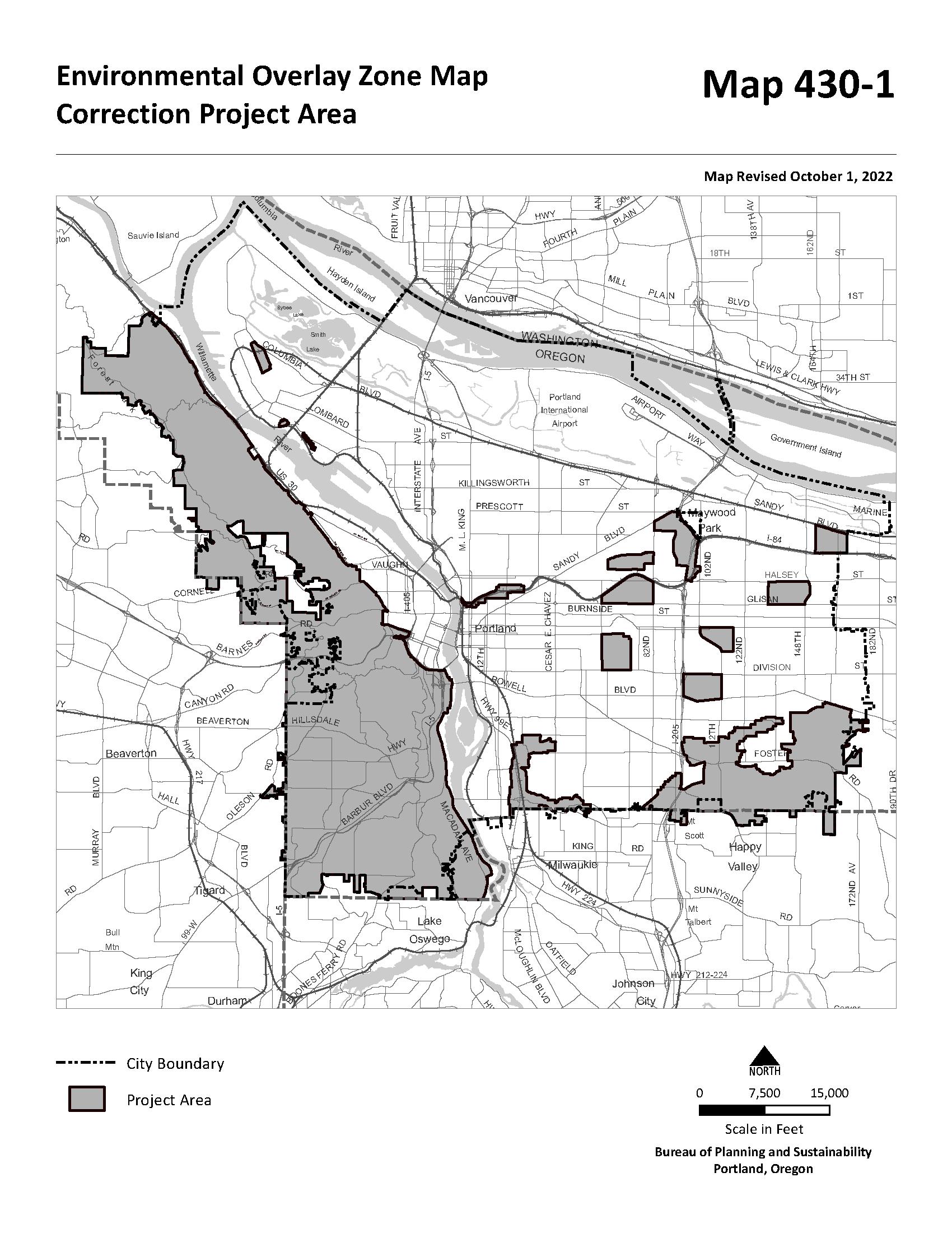
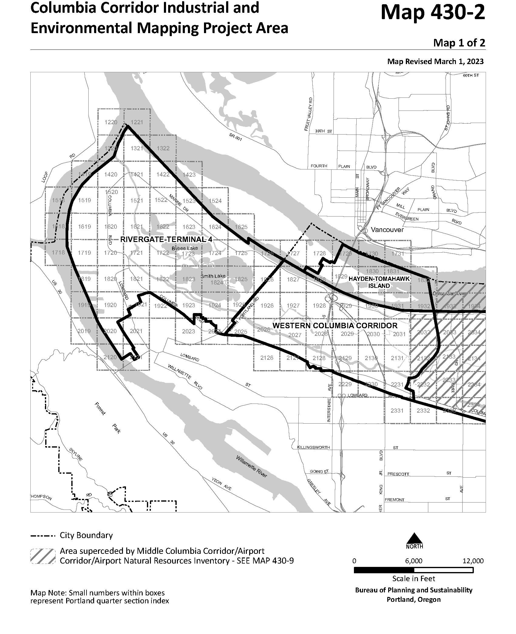
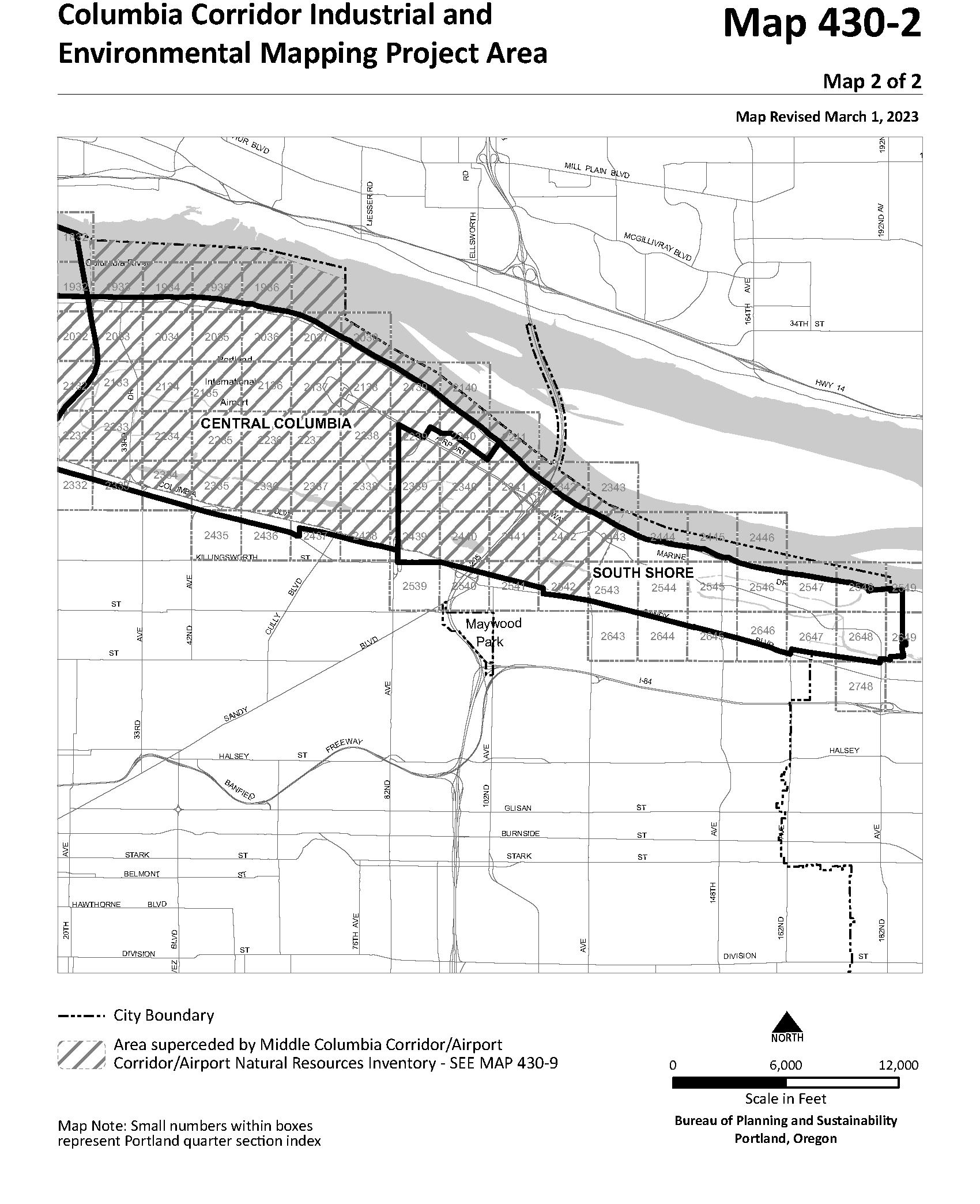
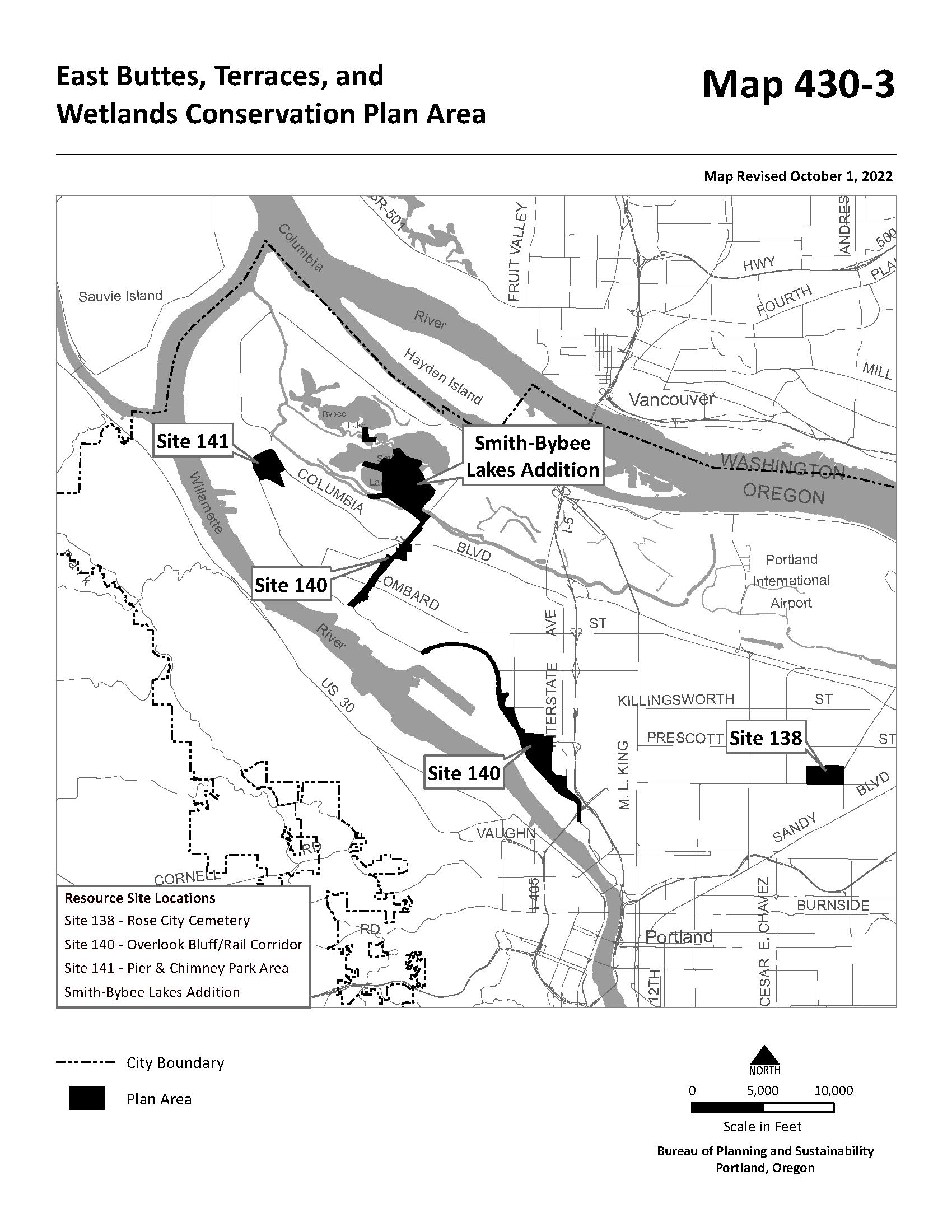
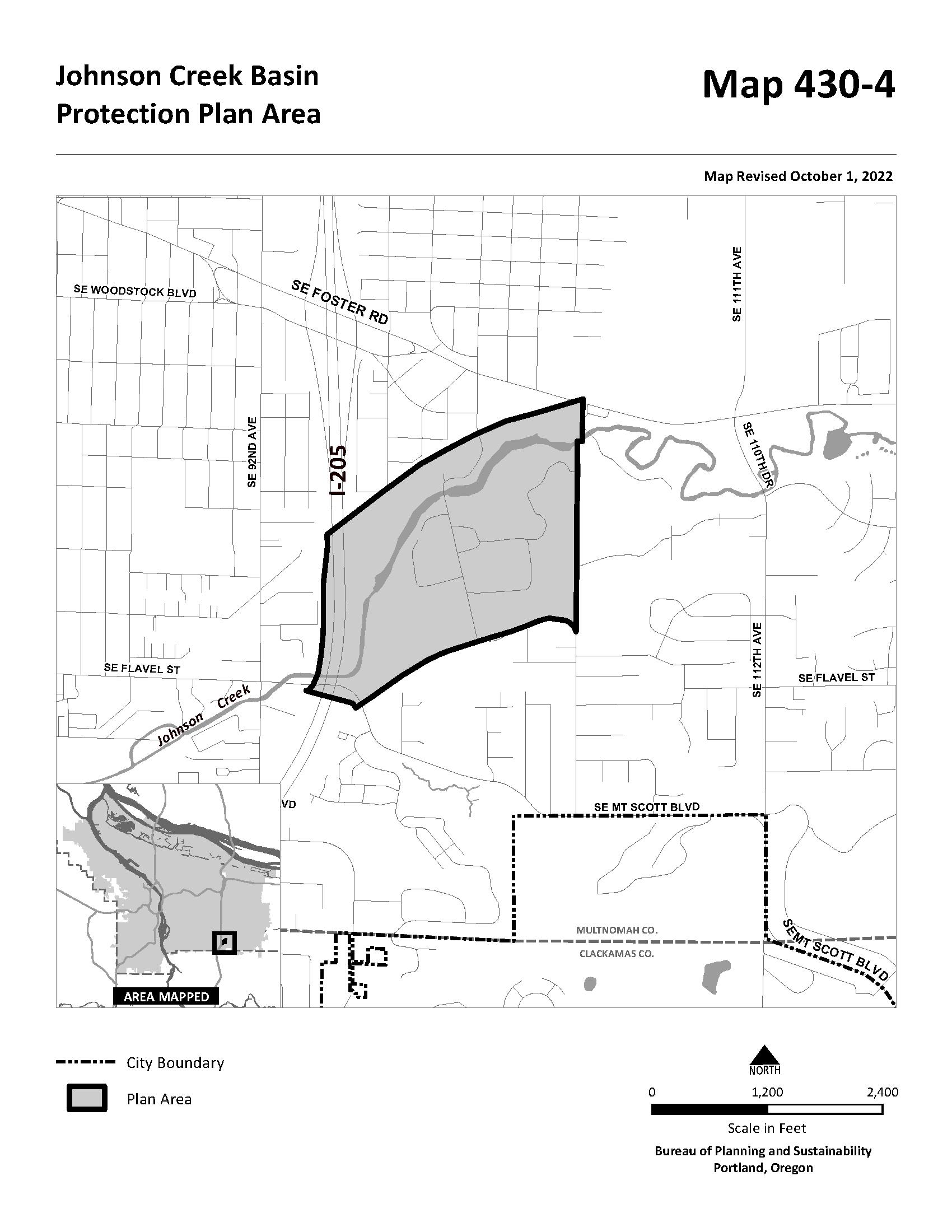
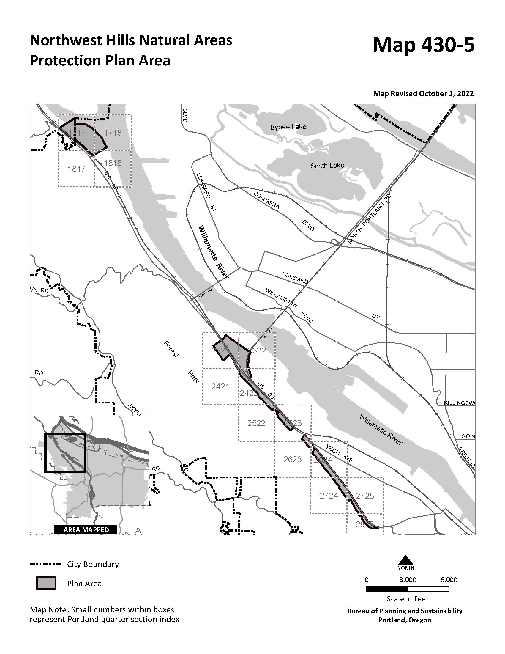
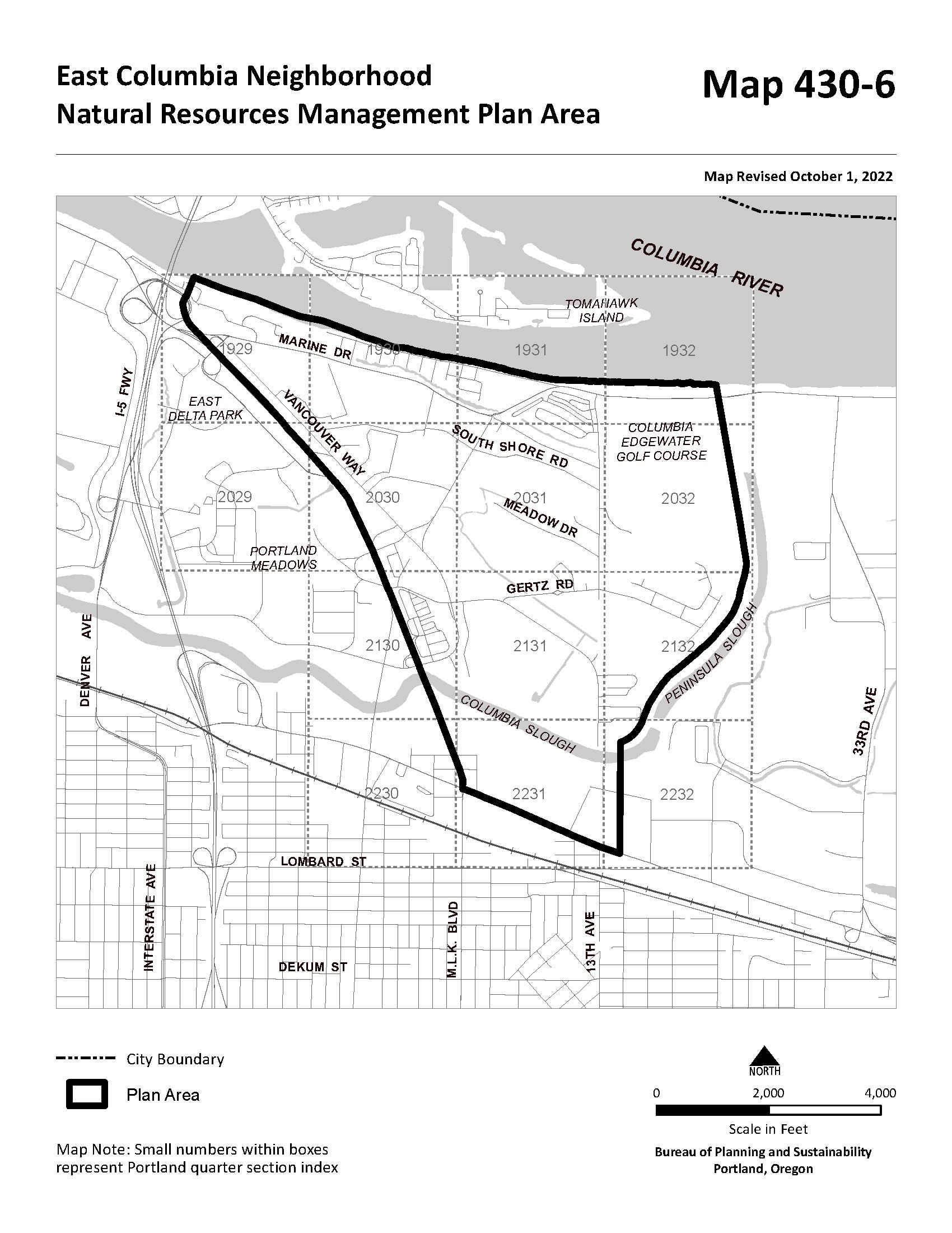
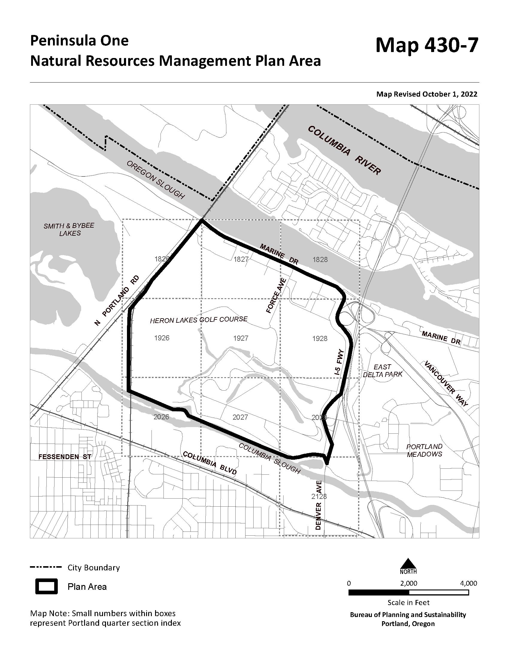
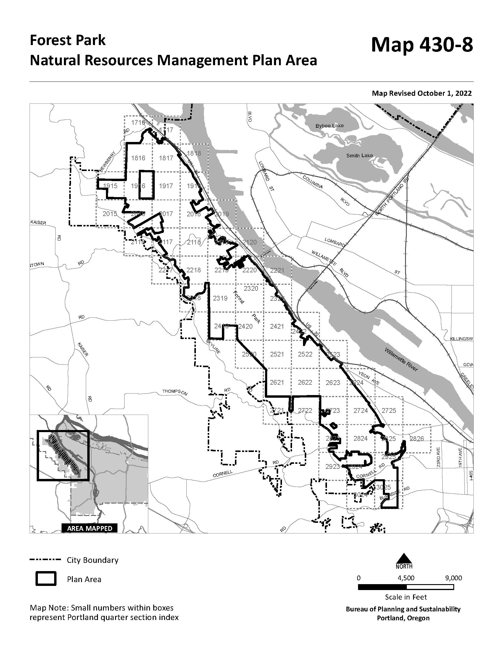
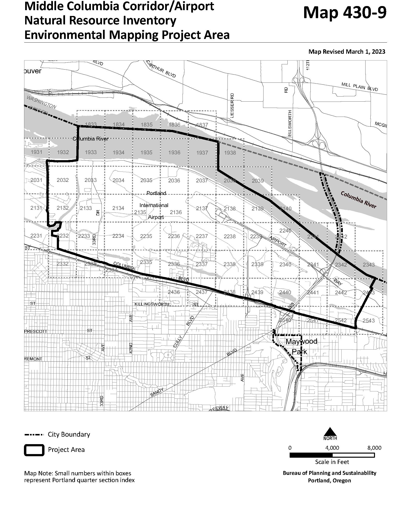
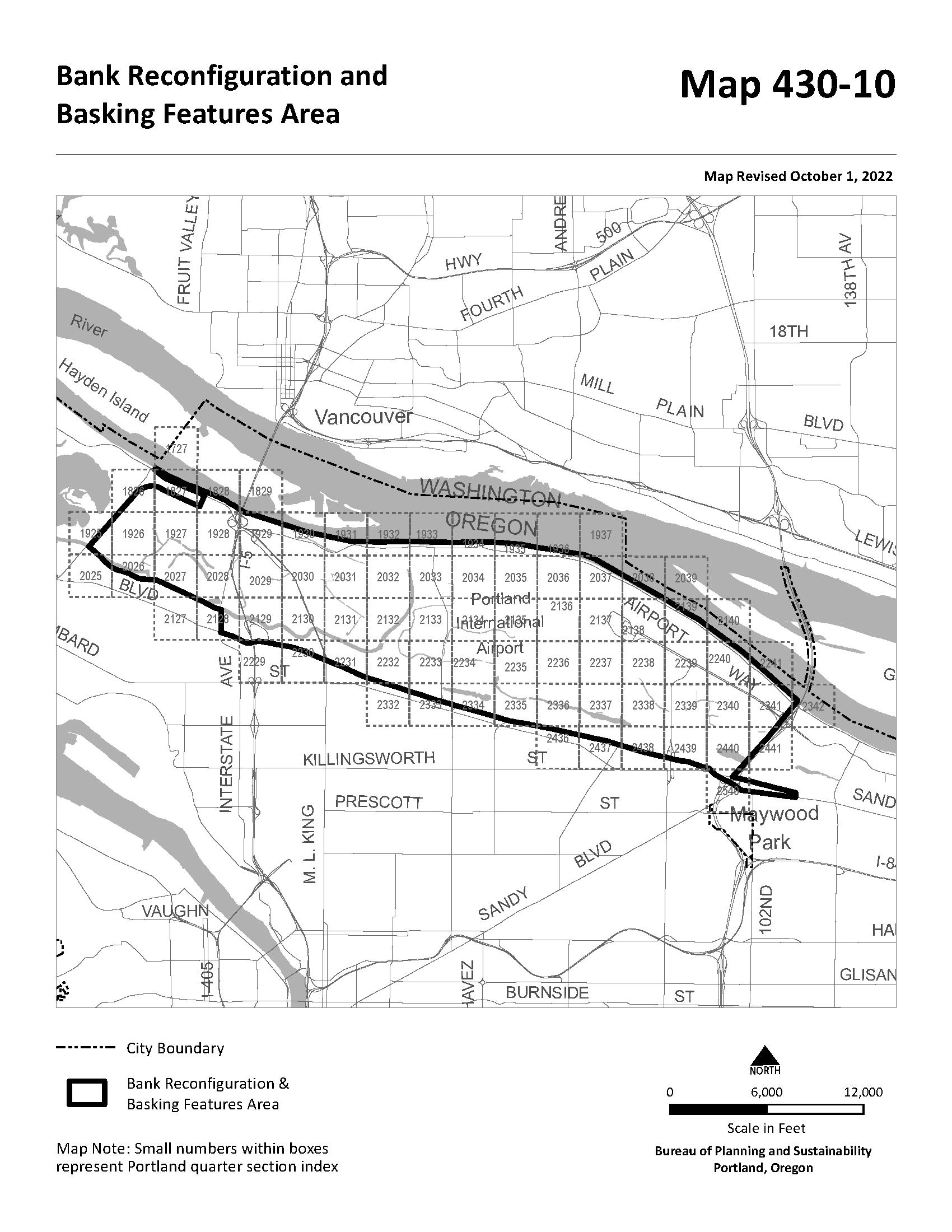

The material and information on this website are made available for general informational purposes only. Although Metro makes reasonable efforts to ensure the accuracy, completeness, and currency of this information, the data and maps may contain errors or inaccuracies. No representations or warranties of any kind, express or implied, are provided.
Address
City
County Multnomah
Taxlot Information
Metro councilor Duncan Hwang Metro councilor
Land Use and Planning
Urban
Sub-watershed Fanno Creek
Sub-basin Tualatin
Urban
Residential hauler Heiberg Garbage Service
Residential hauler phone (503) 794-8212
Commercial hauler Unfranchised
Commercial hauler phone No data
Dropbox provider Unfranchised
Dropbox provider phone No data
School district PORTLAND
School district number 1J
Fire district No data
Park district No data
Sewer district No data
Water district No data
Topography
CUSTOM
MAPS
Water Features
Aerial
Aerial Environmental
Community
Transit
Vacant Land
The information contained is provided by WFG’s Customer Service Department to our customers, and while deemed reliable, is not guaranteed.
Streams
Flood Plain
Wetlands
Rivers
SWSUNSETBLVD
Multnomah Playschool Neveh Shalom Foundation School
Hilltop Preschool & Kindergarten
HILLSDALE
HOMESTEAD
SWSUNSETBLVD
Dewitt Park