CULTURAL LANDSCAPE REPORT


Yosemite Village
Yosemite National Park FEBRUARY 2023
National Park Service • U.S. Department of the Interior
Cover Illustration: Mundus Bishop, 2021.
Publication Credits: Information in this publication may be copied and used, with the condition that full credit is given to the authors, their companies, and the National Park Service. Appropriate citations and bibliographic credits should be made for each use.
Notice: This manuscript has been authored by Mundus Bishop with the National Park Service. The United States Government retains and the publishers, by accepting the article for publication acknowledges that the United States Government retains a non-exclusive, paid-up, irrevocable, world-wide license to publish or reproduce the published form of this manuscript, or allow others to do so, for the United States Government purposes.
United States Department of the Interior Mission Statement: As the Nation’s principal conservation agency, the Department of the Interior has responsibility for most of our nationally-owned public lands and natural resources. This includes fostering sound use of our land and water resources; protecting our fish, wildlife, and biological diversity; preserving the environmental and cultural values of our national parks and historical places; and providing for the enjoyment of life through outdoor recreation. The Department assesses our energy and mineral resources and works to ensure that their development is in the best interests of all our people by encouraging stewardship and citizen participation in their care. The Department also has a major responsibility for American Indian reservation communities and for people who live in island territories under U.S. administration.
National Park Service Mission Statement: The National Park Service preserves unimpaired the natural and cultural resources and values of the national park system for the enjoyment, education and inspiration of this and future generations. The Park Service cooperates with partners to extend the benefits of natural and cultural resource conservation and outdoor recreation throughout this country and the world.

Village Yosemite National Park FEBRUARY 2023 YOSE 104 187380
CULTURAL LANDSCAPE REPORT Yosemite
Acknowledgments
National Park Service
Yosemite National Park
Dawn Bringelson, Cultural Resource Program Manager, Division of Resource Management and Science
Nicole Athern, Ph.D., M.B.A., Division Lead, Resources Management and Science
Cicely Muldoon, Superintendent, Yosemite National Park
Erin (Echo) Davenport, Supervisory Archeologist
Scott Shinton, Historic Landscape Architect
Donald Faxon, Historical Architect
Erin Gearty, Archeologist
Ephriam Dickson, Chief of Interpretation and Education Division
Hope Schear, Section 106 Coordinator and Historic Preservation Officer
Brad Lewis, Landscape Architect/Project Manager
Jim Donovan, Community Planner and Project Manager
Yosemite Conservancy
Schuyler Greenleaf, Chief of Projects
Ryan Kelly, Project Manager
Consultant Team
Mundus Bishop
Anderson Hallas
Chapter 1: Introduction ..................................................................................................................... 1-1 Introduction ........................................................................................................................................................... 1-3 Context and Study Area .................................................................................................................................... 1-4 Project Purpose and Need 1-6 Chapter 2: Site History 2-1 Introduction 2-3 Historical Context and Overview 2-4 Statement of Significance 2-10 Periods of Landscape Development 2-11 Chapter 3: Existing Condition and Analysis .............................................................................. 3-1 Introduction 3-3 Assessment of Integrity 3-5 Study Area 3-10 Yosemite Cemetery ......................................................................................................................................... 3-38 Indian Village of the Ahwahnee .................................................................................................................. 3-42 Valley Visitor Center and Theater Courtyard 3-46 Building and Structures 3-50 Chapter 4: Treatment ...................................................................................................................... 4-1 Introduction 4-3 Rehabilitation Treatment Approach 4-4 Relevant Planning Documents 4-4 Treatment Goals 4-5 General Treatment Guidance 4-6 Detailed Treatment Guidance ........................................................................................................................ 4-8 Yosemite Cemetery ........................................................................................................................................ 4-20 Indian Village of the Ahwahnee 4-20 Valley Visitor Center and Theater Courtyard 4-21 Building and Structures 4-22 Appendices A. Bibliography A-1 B. Treatment Terminology A-6
Table of Contents
This Page Intentionally Left Blank
INTRODUCTION 1
This Page Intentionally Left Blank
INTRODUCTION
This document presents the Cultural Landscape Report (CLR) for Yosemite Village (the study area) within Yosemite National Park (the park). The study area includes the Visitor Services and Administrative Core and the Village Store and Garage Core of Yosemite Village.

This CLR is the primary treatment document for the cultural landscape. This CLR presents detailed documentation of historical development, existing condition, analysis of integrity, and identification of contributing features. This document establishes a treatment philosophy and treatment recommendations to guide long-term care and stewardship of the cultural landscape.
This work builds upon previously developed studies, investigations, and documentation prepared for Yosemite Village and Yosemite Valley Historic District. These include the 2006 Yosemite Valley Historic District National Historic Register Nomination (NRHP), 2020 Draft Yosemite Valley Historic District Amendment, 2014 Merced Wild and Scenic River Comprehensive Management Plan, cultural landscape reports, and historic structure reports developed for sites and buildings within the study area, archeology investigations, and relevant plans and resources reports. Treatment recommendations are consistent with the park’s foundation document.
Numerous projects were underway or in the planning stages for Yosemite Village in the coming years. This CLR will help guide the planning and compliance process for these projects and assist in ensuring modifications and additions fit into the holistic goals of rehabilitation and interpretation of Yosemite Village. The NPS initiated several construction projects during the development of this CLR. This includes Valley Shuttle Stops and Valley Welcome Center and nearby visitor parking. These projects are not documented in existing condition documentation and are not evaluated in the assessment of integrity.
Chapter 1: Introduction 1-3
Figure 1-1. Yosemite Village (source: Mundus Bishop, 2021).
CONTEXT AND STUDY AREA
YOSEMITE NATIONAL PARK AND YOSEMITE VALLEY HISTORIC DISTRICT

Yosemite National Park is comprised of 747,956 acres along the central western slopes of the Sierra Nevada Mountain range in east-central California. The park is internationally recognized for its spectacular granite cliffs, waterfalls, clear streams, giant sequoia groves, and biological diversity and is designated a United Nations Educational, Scientific and Cultural Organization (UNESCO) World Heritage Site. 1.1
The park encompasses one of the largest and most intact habitat blocks in the Sierra Nevada and features trails, campgrounds, climbing areas, bike trails, visitor service facilities, and sites of natural and cultural significance.
Tall granite walls define the relatively level floor of Yosemite Valley. The Merced River meanders through the meadow and riparian habitat of the valley. Although the valley represents less than one percent of the park’s landmass, it is the most highly visited region of the park and serves as the center of visitor services.

Yosemite Village is within Yosemite Valley Historic District (historic district), which is listed as a district in the National Historic Register Nomination (NRHP) for its early and ongoing role in the history of the park and the Mission 66 and Parkscape USA phases of the Mission 66 program. The historic district encompasses six developed areas within Yosemite Valley, including Yosemite Village, The Ahwahnee, Curry Village, Yosemite Lodge, Housekeeping Camp, and Pines Campgrounds.1.2
1.1 United States Department of Interior, National Park Service, Foundation Document – Yosemite National Park, (Yosemite: Yosemite National Park, 2016), 3.
1.2 United States Department of the Interior, National Park Service. National Register of Historic Places NominationYosemite Valley Historic District Historic District Amendment (draft). (San Francisco: Architectural Resource Group, 2020), 2.
Yosemite Village Cultural Landscape Report 1-4
Yosemite National Park Tuolumne Meadows Visitor Center Yosemite Village Historic District T oga Road Va ley LoopRoad W a w ona Southside Drive Glacier PointRoad Northside Drive Merced River Yosemite Valley Historic District The Ahwahnee Curry Village Yosemite Village
STUDY AREA
Yosemite Village is centrally located in Yosemite Valley on the northern side of the Merced River. The developed area of the study area is set within stands of deciduous trees—primarily black oak interspersed with ponderosa pines and incense cedars—with views to Cook’s Meadow to the southwest, Yosemite Falls to the northwest, and granite walls and mountain peaks in all directions.
Yosemite Village was originally developed by the NPS as the civic core of the park to provide for visitor services and administrative functions. It continues this role today. The study area consists of two distinct areas—the Visitor Services and Administrative Core and the Village Store and Garage Core.1.3
Visitor Services and Administrative Core includes the Administration Building, Yosemite Museum, Valley Visitor Center and Theater, Ansel Adams Gallery, Rangers' Club, Post Office, Indian Village of the Ahwahnee, Yosemite Cemetery, and Village Mall. Village Store and Garage Core includes Village Store, Concessioner Garage, Garages 1, 2, 3, and 4, Engine 7, and visitor parking.
The study area is part of the larger Yosemite Valley Historic District and is associated with the early development of the park and the NPS rustic style and the Mission 66 program. Yosemite Village is also within the larger Yosemite Valley Archeological District with archeological sites indicating indicate American Indians were present in this natural landscape for at least 4,000 years before development of Yosemite Village.1.4 1.5
1.4 United States Department of the Interior, National Park Service. National Register of Historic Places NominationYosemite Valley Archeological District. (Yosemite: Yosemite National Park, 1976), 1.
1.5 Mission 66 includes three phases: Pre-Mission 66 (1945-1955), Mission 66 (1956-1966), and Parkscape USA (19671972). No Yosemite Village improvements exist from the Pre-Mission 66 phase.

Chapter 1: Introduction 1-5
1.3 The Yosemite Valley Historic District does not identify a Visitor Services and Administrative Core or a Village Store and Garage Core. This distinction is based on landscape character areas identified in the 1994 Yosemite Valley Cultural Landscape Report.
Figure 1-4. Yosemite Village consists of two distinct areas—the Visitor Services and Administrative Core and the Village Store and Garage Core (source: Mundus Bishop, 2022).
Yosemite Village
Merced River Sentinel Drive Southside Drive AhwahneeDrive VillageDrive Northside Drive NorthsideDrive Vil age Drive Tec oy a Ro a d
Visitor Services and Administrative Core Village Store and Garage Core
PROJECT PURPOSE AND NEED REPORT METHODOLOGY
This document was prepared in accordance with The Secretary of the Interior’s Standards for the Treatment of Historic Properties and Guidelines for the Treatment of Cultural Landscapes, conducted at a thorough-level investigation and documentation.
1.6
A review of select documentation of known and presumed relevance from readily available primary and secondary sources included documents from the park archives, park library, and the NPS’s ETIC and IRMA databases. Planning documents, administrative reports, technical reports, cultural resource studies, natural resource studies, and correspondence were reviewed. Review of historical documentation included drawings and photographs, correspondence from primary and secondary sources, and archeological documentation. This CLR did not include archeological or ethnographic investigations.
Background data provided by the NPS was used to prepare drawings and illustrations, which included historic drawings. Site investigations conducted in Fall 2021 documented existing conditions through field reconnaissance and were conducted according to best practices.
PARK PURPOSE AND SIGNIFICANCE
President Abraham Lincoln signed the Yosemite Grant in 1864, designating Yosemite Valley and Mariposa Grove as scenic natural areas and granting the lands to the State of California. This marked the first act of public land being set aside in the United States to “be held for public use, resort, and recreation...inalienable for all time” and was critical to the creation of a national park system. Yosemite National Park was established by the U.S. Congress in 1890 and included the surrounding mountains and forests of Yosemite Valley but excluded Yosemite Valley and Mariposa Grove. Yosemite Valley was ceded by the State of California to the United States in 1905 along with Mariposa Grove of Big Trees. The U.S. Congress accepted the state grant in 1906 and added these lands to Yosemite National Park.
The purpose of Yosemite National Park is to preserve the dynamic natural setting within the park’s boundaries, including soaring granite domes, dramatic cliffs, towering waterfalls, ancient sequoia groves, expansive wilderness terrain, and freeflowing wild and scenic rivers; to celebrate the cultural and historic traditions of the Central Sierra Nevada, including thousands of years of human history; to perpetuate the American conservation ethic; and to provide opportunities for scientific exploration, recreation, education, and inspiration for generations to come.1.7
Yosemite Village Cultural Landscape Report 1-6
1.6 Page, Robert R., Cathy A. Gilbert, and Susan A. Dolan, A Guide to Cultural Landscape Reports: Contents, Processes and Techniques, (Washington D.C.: National Park Service, 1998).
1.7 United States Department of Interior, National Park Service, Yosemite National Park Foundation Document, (Yosemite: Yosemite National Park, 2016), 5.
The park's 2016 Foundation Document describes the significance of the park, Yosemite Valley, and Yosemite Village as follows.1.8
• The park is noted for its outstanding scenery.
• The park contains a unique assemblage of massive granite domes and glacial features, resulting from a rich geologic history. Several of the largest exposed granite monoliths on earth are in Yosemite Valley.
• In connection with its neighboring national parks and forests, the park is at the center of the second largest contiguous area of designated wilderness in the lower 48 states.
• The park contains extensive blocks of intact old growth forests, including three groves of giant sequoia trees— the first to be protected by law—as well as some of the largest known specimens of several tree species.
• The park contains extensive reaches of two designated wild and scenic rivers—the Tuolumne and the Merced. In addition to their free-flowing condition and exceptionally high water quality, both have remarkable values that are of geological, cultural, scenic, and recreational importance.
• The park includes the headwaters of two of California’s major watersheds, providing clean drinking water to millions of people in the San Francisco Bay Area and are a valuable source of water to the agricultural industry in California’s Central Valley. The forests and meadows of these watersheds enhance ecological resilience to help offset the impacts of climate change.
• Alpine and sub-alpine lakes and meadows abound in the park.
• The park is a vital living research laboratory, a sanctuary, and an example of a relatively pristine natural environment. This is of special significance in California, a state with a rapidly growing population.
• The vast landscape of the park provides refuge for the survival and recovery of many rare, endemic, and threatened or endangered species. The park is home to a diversity of living things, fostered by a broad elevation range and the sequence of climatic zones contained within its boundaries.
• Land preserved within the park is part of the ancestral homeland of several contemporary American Indian tribes.
• The park was the first scenic natural area to be set aside by the United States for public benefit and appreciation of landscape beauty. Yosemite Valley and the Mariposa Grove were the 1864 birthplace of the national park idea.
• The park has international recognition for its past and present role as a leader in park preservation, management, and partnerships. Important elements include the role of the U.S. Army (including Buffalo Soldiers), the first female ranger (1917),
Chapter 1: Introduction 1-7
1.8 NPS, Yosemite National Park Foundation Document, 6-7.
the formal institution of interpretation (1920), participation in the evolution of 150 years of public-use management, the first wildlife management program in the NPS as inspired by George Wright (late 1920s), and establishment of the first nonprofit stewardship partners in the NPS (1923).
• The park was the home of the first NPS landscape design office, providing design services for all parks in the West. The park represents the birthplace of the NPS Rustic Style of architecture and numerous important historic structures.
• The decision-making and stewardship actions taken at the park inspire an international audience and influence stakeholders, policymakers, and communities worldwide. The park has a distinction as a UNESCO-designated World Heritage Site.
• Yosemite Valley and Camp 4 have played a significant role in the history of big wall climbing and the development of climbing techniques and equipment, which have since gained worldwide acceptance.
MANAGEMENT
Yosemite Village is managed by the NPS as part of Yosemite National Park. The study area's management is guided by the park’s Foundation Document; its inclusion within Yosemite Valley Historic District and Yosemite Archeological District; and through the Merced Wild and Scenic River Comprehensive Management Plan (MRP). Concessioner services within Yosemite Village are provided by Yosemite Hospitality, LLC, a subsidiary of Aramark, who manages food, beverage, and retail services at Degnan’s Kitchen and Village Store within the study area.
Management issues identified by the CLR scope of work include those provided through discussions with park staff and through findings during field reconnaissance conducted in Fall 2021. These issues assist in defining treatment guidance for Yosemite Village.
• Guidance is needed to improve the overall condition of the cultural landscape and address the next twenty years of appropriate maintenance, operations, and interpretive objectives.
• Rehabilitation recommendations are needed for the circulation system (e.g., clarifying, rerouting, widening, and reducing paved surfaces), wayfinding and site orientation, and universally accessible access throughout the cultural landscape.
• View and vista preservation and rehabilitation recommendations are needed.
• Rehabilitation recommendations for views and vistas, vegetation, and small scale features are needed.
Yosemite Village Cultural Landscape Report 1-8
SITE HISTORY # 2
Page Intentionally Left Blank
This
INTRODUCTION
This chapter presents an overview of the physical evolution of the study area from its origins as lands inhabited by indigenous peoples to its development as the center of administration and visitor services in Yosemite Valley. The site history includes the study area's development in the early twentieth century as part of the establishment of Yosemite National Park and modifications completed during Mission 66.
Yosemite Village was one of several well-defined clusters of development established by the National Park Service (NPS) shortly after the establishment of the national park. Between 1924 and 1926, the NPS and concessioners built buildings and structures to support administration and the increasing number of visitors to the valley and larger park. This included Administration Building, Yosemite Museum, Post Office, photography studios, and several garage buildings.
Initial development embodied the NPS rustic style principles of preserving natural resources and scenic qualities through harmony with the landscape. Clustered development, spatial arrangement, site design architecture, and use of natural materials are characteristic of the NPS rustic design aesthetic.
Modifications and additions completed in the 1950s and 1960s as part of Mission 66 introduced a modern aesthetic to design and construction. Mission 66 improvement expanded visitor services, improved vehicular circulation, and modernized facilities for interpretation. Mission 66 additions included Valley Visitor Center and Theater, Degnan’s Kitchen, Village Store, and Comfort Station.
This chapter provides a historical context and overview of the development of the study area and a statement of significance for Yosemite Village with a period of significance of 1855 to 1966.2.1 A summary and chronology organized into five periods of physical development and change describe the evolution of the study area in greater detail.
Chapter 2: Site History 2-3
2.1 This matches the period identified in the 2006 NRHP nomination and 2020 amendment for the larger Yosemite Valley Historic District.
HISTORICAL CONTEXT AND OVERVIEW
Yosemite Village represents ambitious and historically significant advancements in the preservation of natural and scenic resources, planning of park villages, and development of unified architectural styles—from its original development in the early twentieth century as part of the establishment of Yosemite National Park to its modification by the Mission 66 program. Yosemite Village exemplified early NPS directives to protect resources and elevate the planning and design of national parks with influential planners and designers developing principles and standards that were replicated in national parks throughout the country.
Tourists who were inspired by reports of a thousand-foot waterfall first visited Yosemite Valley in 1855. Accounts of this first trip were republished throughout the country, capturing national attention and sending tourists, landscape painters, and settlers to Yosemite Valley. Development expanded as settlers established hotels, built homes, brought livestock to graze, and planted orchards throughout Yosemite Valley.
The 1864 Yosemite Grant was enacted to protect the valley as a scenic natural area as continued development threatened the scenic and natural resources of Yosemite Valley.2.2
The state appointed commissioners to manage lands included in the 1864 grant. Frederick Law Olmsted, chairman of the commission, prioritized public access and the protection of the natural beauty of Yosemite Valley.2.3
Despite the commission's attempts growth and development continued to threaten scenic and natural resources of Yosemite Valley. John Muir and Robert Underwood Johnson, editor of The Century Magazine, visited Yosemite Valley and were appalled to find the valley “despoiled by commercialism and exploitation.” They believed the commission’s management would ruin the valley’s landscape.2.4
The U.S. Congress established Yosemite National Park in 1890 to protect the larger Yosemite landscape. The park did
not initially include Yosemite Valley and the valley remained under California’s authority.2.5
Yosemite Valley was receded by the California legislature to the federal government in 1905. The federal government moved to relocate their facilities from Old Village to a new center for government and civic use at the park (Yosemite Village). Old Village, a small community south of the Merced River, had organically grown into the administrative and commercial center of the park. Old Village was prone to flooding and in poor condition but provided essential services to the growing number of visitors to Yosemite Valley. The directive to demolish Old Village and move facilities to Yosemite Village was indicative of the mission of the newly established National Park Service to protect natural resources and elevate the planning and design of national parks through comprehensive plans for park development.
Yosemite Village Cultural Landscape Report 2-4
2.2 NPS, Historic Resource Study, 33.
2.3 NPS, Sense of Place, 28-29.
2.4 NPS, Sense of Place, 30.
2.5 United States Department of the Interior, National Park Service, Tuolumne Meadows Cultural Landscape Inventory (Oakland: National Park Service, Pacific West Regional Office, 46.
Landscape engineer Mark Daniels was hired to develop a plan for Yosemite Valley and Yosemite Village in 1914 by the Department of the Interior Secretary Franklin Lane. Daniels' plan was not implemented, but it established principles that served as a basis for park village planning throughout the NPS, including a unified architectural style, strong visual relationships between public spaces and natural features, zoning by use, and a hierarchy of street types. Daniels described the importance of establishing planned park villages at the 1915 National Park Conference.2.6
“In the Yosemite Valley there are times when there are five or six thousand people congregated at one time. That community ceases to be a camp; it becomes a village. It can no longer be administered or looked upon in the light of a camp. It has its municipal problems. There are many incorporated cities in this State and in the United States that do not have
5,000 in population. This village has the population of a municipality. It must have a sanitary system, a watersupply system, a telephone system, an electric light system, and a system of patrolling. There is no instance in the United States of any village that grew to any size without some forethought, without some planning, that did not turn out to be an ugly repellent object. For that reason, if for no other, it is absolutely essential that we take care of the villages in these various parks.”
Mark Daniels
2.7
Stephen Mather, appointed as director of the NPS in 1916, planned to elevate Yosemite National Park as the showplace of the national park system and establish Yosemite Village as the civic core of the park. His vision for quality planning and design prompted a comprehensive study of park structures and the creation of a landscape engineering division within the NPS.2.8
Charles Punchard was hired by Director Mather to serve as the NPS’s landscape engineer and was responsible for ensuring quality architectural design and landscape planning in parks. Punchard was stationed in Yosemite National Park between 1918 and 1919 to develop Director Mather's vision and identify the location of Yosemite Village.2.9
Although Yosemite Village was central to Director Mather's vision for Yosemite National Park, Old Village concessioners contested relocation to the new village as they believed the move would negatively impact business. Director Mather believed concessioners could be swayed if the NPS took the lead in developing Yosemite Village. He successfully convinced the U.S. Congress of the importance of adequate appropriations for park infrastructure and received funding for the design and construction of Yosemite Village and personally donated funds for the design of Rangers' Club, the first government building in Yosemite Village.
2.6 United States Department of the Interior, National Park Service. National Register of Historic Places Nomination - Yosemite Valley Historic District. (Yosemite: Yosemite National Park, 2006), 62.
2.7 United States Department of the Interior. Proceedings of the National Park Conference Held at Berkeley, California. (Washington: Washington Government Printing Office, 1915), 19, 20.
2.8 McClelland, Linda. Presenting Nature: The Historic Landscape Design of the National Park Service 1916 to 1942, (Washington, D.C., 1993), 79-80, 86.
2.9 NPS, 2006 Yosemite Valley Historic District, 63.
Chapter 2: Site History 2-5
Punchard's design of Rangers' Club formed the foundations of NPS rustic design that served as the standard for the national park system from 1916 to 1940. The NPS rustic style relied on natural materials—native stone, timbers, shakes, and shingles—and was designed to harmonize with the natural landscape.2.10
Myron Hunt, Daniel Hull, and Thomas Vint, architects and landscape architects for the NPS, advanced earlier concepts for Yosemite Village in 1924. Their comprehensive plan reflected Punchard's solution for park villages that was implemented in national parks throughout the 1920s and early 1930s. Punchard's design clustered administrative and commercial buildings along three sides of a village square with a road along the fourth.2.11
Hunt, Hull, and Vint's plan organized Yosemite Village into three concentrated zones of development organized by use— administration, residential, and maintenance. The design of Yosemite Village thoughtfully identified building sites, expressed a unified architectural style that harmonized with the natural environment, capitalized on strong visual relationships between public spaces and natural features, and established a hierarchy of roads. Park administration and visitor service buildings were organized around a central plaza (Yosemite Village Plaza).2.12
Yosemite Village was dedicated in 1924 and Old Village buildings were incrementally removed over the next forty years. Initial NPS development included Administration Building, Yosemite Museum, Post Office, and Yosemite Village Plaza. Initial concessioner development included Pillsbury Studio, Best Studio, Foley Studio, Concessioner’s Headquarters, and Concessioner Garage.2.13
“This plan places the unit on the opposite side of the valley from the present village and offers every advantage to the establishment of the various general stores, studios, and shops in satisfactory relation to the administration building and the post office. All buildings erected will, of course, be built in accordance with plans approved by the service and no opportunity will be lost to have the structures harmonize with their natural surroundings.”
Daniel Hull 2.14
2.10
2.11
2.12
2.13 United States Department of
2.14
Interior, National Park Service and Land & Community Associates. Yosemite Valley Cultural Landscape Report, Vol. 1-2. (Yosemite: Yosemite National Park, 1994),
Yosemite Village Cultural Landscape Report 2-6
NPS, Sense of Place, 32.
McClelland, Presenting Nature, 87.
NPS, Sense of Place, 101.
the
1-6.
McClelland, Presenting Nature, 96.

Chapter 2: Site History 2-7
Figure 2-1. Administration Building (left) and Yosemite Museum (right) within Yosemite Village Plaza. View from parking to Yosemite Falls, c. 1941 (NPS Gallery - 1031 Yosemite Historic Photo Collection).
New Deal programs furthered the improvement of Yosemite Village between 1933 and 1942. The Civilian Conservation Corps (CCC) focused on the beautification of Yosemite Village, and the Public Works Administration (PWA) completed capital improvements based on master plans. NPS landscape engineers supervised work and continued to further develop the NPS rustic style. New Deal improvement of Yosemite Village included placing log curbing along roads and parking, maintaining trees, planting native ferns, trees, and shrubs around buildings, and improving Yosemite Museum Garden (present-day Indian Village of the Ahwahnee).2.15
The CCC's improvement of Yosemite National Park ended when the United States entered World War II (WWII) in 1941. The NPS limited the improvement of Yosemite Village during the war to work essential for the protection of resources and public use facilities.
Although development of Yosemite Valley slowed during WWII, Thomas Vint, NPS
landscape architect, recognized future development was imminent and would cause unacceptable damage to the scenic and natural resources of the valley. Vint’s 1945 plan for Yosemite Valley recommended establishing the valley as a day use destination and relocating administrative and overnight accommodations outside the valley. The plan did not receive Yosemite’s Board of Expert Advisors’ endorsement as the valley was the “heart of the park” and the primary destination for most visitors.
in 1966, the NPS’ fiftieth anniversary. Wirth presented the Mission 66 prospectus to President Eisenhower in January 1956 and received the president’s endorsement.
2.16
Visitation to national parks rebounded dramatically after WWII ended. Increased prosperity, leisure time, and automobile use and ownership put pressure on the national parks. Postwar budgetary constraints coupled with the overuse of parks and lack of repaired or new facilities resulted in deterioration of park facilities and degradation of resources and reached crises proportions. NPS Director Conrad Wirth presented a plan, Mission 66, to modernize and expand the national park system in 1956. Mission 66 was named after the target date for the plan’s completion
Mission 66 improvement introduced a modern aesthetic to Yosemite Village and focused on improving visitor use and interpretation. Mission 66 additions and modifications included Valley Visitor Center and Theater, Comfort Station, Post Office Garage, Degnan’s Kitchen, Village Store, and expanded parking areas throughout the village. Northside Drive and Village Drive were realigned in the late 1950s to alleviate congestion in the study area and allow visitors to bypass traffic at Village Store, Degnan's Kitchen, and Yosemite Village Plaza.
Yosemite Village Cultural Landscape Report 2-8
2.15 NPS, Sense of Place, 36.
2.16 Carr, Ethan. Mission 66 Modernism and the National Park Dilemma, (Amherst: University of Massachusetts Press, 2007), 247.
The NPS closed Yosemite Village Plaza to vehicular traffic in 1972. This contrasted the Mission 66 emphasis to modernize roads and expand parking and instead prioritized concerns associated with unrestricted access within Yosemite Valley and riots that erupted in the park in 1970. The conversion of the civic center of Yosemite National Park was a symbolic end to the practice of continuous expansion of parking and represented the park's new objective of encouraging visitors to get out of their cars and use shuttles.
Yosemite Village improvements initiated after completion of Mission 66 primarily addressed resource protection, visitor congestion, and visitor services. Major improvements and modifications to the study area included the redesign of Yosemite Village Plaza as a pedestrian mall (Village Mall), shuttle service and associated infrastructure, and removal of facilities within the wild and scenic corridor of Merced River.
Mission 66 institutionalized an NPS systemwide approach to planning and design. It emphasized the use of master plans and parkwide studies, instilled new planning procedures, and defined cohesive design concepts that embraced the Modern movement, e.g., the use of cost-efficient materials and construction systems. The program focused on facilitating public enjoyment by providing amenities for the exponential growth in visitation.
Mission 66 emphasized conservation and preservation of natural resources as the new identity of the NPS. Mission 66 planning concentrated development into clusters to protect natural resources and grouped facilities by use and function. This assured “balanced relationships between preservation of the park resources and visitor needs.” Mission 66 focused on a modern design aesthetic for buildings, structures, and features but retained the naturalistic principle of harmonizing with nature.
The Mission 66 program introduced a new building type, the visitor center, as a successor to museums and centerpiece of the reinvented NPS. Visitor centers were located at park entrances, along major roads, and at major destinations. Visitor centers were designed to be subservient to the landscape through the design of low buildings massed into smaller units and the use of materials and colors blending with the site.2.17
The NPS completed the Mission 66 Prospectus for Yosemite in August 1956 and approved the plan in May 1957. Aspects of the prospectus reflected the 1945 Vint Plan. The prospectus recommended adequate roads and trails, accommodations and facilities for visitors, interpretation of resources, and facilities and personnel necessary for administration, maintenance, and protection of the park. Park authorities planned to limit facilities in Yosemite Valley to those essential for visitor use with supporting facilities for parkwide operations located elsewhere.2.18
Chapter 2: Site History 2-9
2.17 Carr, Ethan. National Park Service Mission 66 Era Resources Multiple Property Documentation Form. (Santa Fe: National Park Service Intermountain Regional Office, 2015), 13-17, 44.
2.18 NPS, Historic Resource Study, 753-754.
STATEMENT OF SIGNIFICANCE
The recommended period of significance for Yosemite Village is 1855 to 1972. This period recognizes two major initiatives of the NPS—NPS rustic design and Mission 66. The study area, in its entirety, was designed by the NPS beginning in 1914 and largely built between 1924 and 1926. Modifications and additions of buildings and roads were completed by Mission 66 between the 1950s and 1970s. Mission 66 improvement followed the earlier naturalistic design principles in a new, modern aesthetic.
Yosemite Village was initially planned by the NPS to address the growing need to provide administrative and visitor services and concerns associated with the impacts of development to the natural and scenic resources of Yosemite Valley. Preliminary village planning completed by landscape architect Mark Daniels served as a basis for subsequent village plans within Yosemite Valley and across the entire NPS.
Stephen Mather, director of the NPS, appointed Charles Punchard as the agency's first landscape engineer and established Yosemite National Park as the headquarters
of the Landscape Engineering Division of the NPS. Punchard was tasked to further develop Daniels' plan for Yosemite Village to ensure quality design and planning throughout the NPS. His design of Rangers' Club established the foundations of the NPS rustic style that served as the standard for the entire national park system from 1916 to 1940.
Myron Hunt, Daniel Hull, and Thomas Vint advanced Punchard’s concept for Yosemite Village in 1924. Initial development was designed and built in the NPS rustic style between 1924 and 1926. NPS facilities included Administration Building, Yosemite Museum, Post Office, and Yosemite Village Plaza. Concessioner facilities included Pillsbury Studio, Best Studio, Foley Studio, Concessioner’s Headquarters, Concessioner Garage, and several smaller garages. Yosemite Village represents one of the largest collections of NPS rustic style buildings in the NPS.
Mission 66 represents the last major development initiative implemented by the NPS in the twentieth century.
Mission 66 improvement introduced a modern aesthetic to Yosemite Village and focused on improving visitor use and interpretation. Mission 66 additions and modifications included Valley Visitor Center and Theater, Comfort Station, Post Office Garage, Degnan’s Kitchen, Village Store, and expanded parking areas and road realignments throughout the village to alleviate congestion. Valley Visitor Center and Theater, Comfort Station, Degnan’s Kitchen, and Village Store combined costefficient materials with Modernist design to reflect a style of park building representative of the modern era. The Modern Movement style served as the basis for the national park system from 1945 to 1972.2.19
Yosemite Village is part of Yosemite Valley Historic District, which was listed in the National Register of Historic Places in 2006 with a period of significance from 1855 to 1942. An update to the Yosemite Valley Historic District was drafted in 2020 to include historic resources from Mission 66. The period of significance for Mission 66 resources is from 1945 to 1972.
2.19 Mission 66 includes three phases of planning, design, and construction: Pre-Mission 66 (1945-1955), Mission 66 (1956-1966), and Parkscape USA (1967-1972).
Yosemite Village Cultural Landscape Report 2-10
PERIODS OF LANDSCAPE DEVELOPMENT
Five periods of landscape development describe the physical evolution of the cultural landscape from the earliest use of the area by indigenous peoples through the present day. The beginning and end of each period corresponds to and documents major physical changes in the cultural landscape.
YOSEMITE VILLAGE PERIODS OF
DEVELOPMENT
1800
EXCLUSIVE INDIGENOUS OCCUPATION (TO C. 1855)
2.20
Merced River was well established before glaciation. Glaciers followed the route of Merced River and created its present-day course 10,000 to 1.8 million years ago. Retreating glaciers left behind the U-shaped gorge of Yosemite Valley and sheer granite walls, woodlands, and meadows of the valley.
2.21
Humans have occupied the region for more than 10,000 years. Bedrock mortars and pestles, midden deposits, lithic scatters, rock shelters, oral histories, and cultural ties indicate the enduring importance and value of the study area to American Indians.
Central and Southern Sierra Miwuk primarily
occupied the park within late prehistoric and historic periods. Woodlands and open meadows of Yosemite Valley provided rich habitat. Miwuks subsisted on the valley’s diverse resources in prehistoric and early historic periods. They followed seasonal subsistence patterns and gathered clover and bulbs in the spring; seeds and fruits in the summer; acorns, nuts, and manzanita berries in the fall; mushrooms in the late winter and early spring; and hunted grizzly bears, black bears, deer, elk, and small mammals, and fished along the Merced River.
The Ahwahneechee, a subset of the Miwuks, built permanent and seasonal villages for hunting, gathering, and fishing in Yosemite Valley for thousands of years and burned the meadows to facilitate growth of black oak trees, whose acorns were a critical source of food. 2.22
2.20 The scope of this CLR does not include documentation of the Exclusive Indigenous Occupation period and does not include ethnographic and archeological research. This summary is provided for context.
2.21 United States Department of the Interior, National Park Service. Merced Wild and Scenic River Final Comprehensive Management Plan and Environmental Impact Statement, Vol 1-3B, (Yosemite: Yosemite National Park, 2014), 5-63.
2.22 Historic accounts often refer to the Ahwahneechee as Yosemite Indians. The Ahwahneechee called their home Ahwahnee, the Indian word for mouth. This name connects the Ahwahneechee to Yosemite Valley and likens the valley’s shape to a gaping mouth.
NPS, Historic Resource Study, 1-3.
1850
Euro-American Exploration and YOSE Establishment (1855 to 1919)
Yosemite Village Period of Significance (1855-1972)
1900
1950 2000
NPS Rustic and New Deal Development (1920 to 1955) Mission 66 and Parkscape USA Development (1956 to 1972)
Contemporary Alterations (1973 to present)
2.23 American Indian stewardship, traditional use, and use and connections to the study area extend beyond 1855 to present-day but were irreversibly altered by the establishment of the national park and Yosemite Village, displacement of individuals from Yosemite Village to Indian Village, and federal housing and employment mandates.
Chapter 2: Site History 2-11
Exclusive Indigenous Occupation (to c. 1855)
2.23
EURO-AMERICAN EXPLORATION AND ESTABLISHMENT OF YOSEMITE NATIONAL PARK
(1855 TO 1919)
The early planning and design of Yosemite Village exemplified the National Park Service (NPS) directive to protect natural resources and elevate the planning and design of national parks through comprehensive plans for park development. Director Stephen J. Mather planned to establish Yosemite National Park as the showplace of the national park system and establish a new civic center for the park at Yosemite Village.
Director Mather hired Charles Punchard, the first NPS landscape engineer, to ensure quality architectural design and landscape planning for the NPS. Punchard was stationed at Yosemite National Park to advance earlier plans and locate a site for NPS and concessioner development in Yosemite Valley.
Preliminary planning and design of the study area served as the basis for subsequent plans for Yosemite Village. Punchard's work at Yosemite Village established a model for a unified architectural style (NPS rustic design) that served as the standard for the national park system from 1916 to 1940.2.24
1849 to 1852
Thousands of miners traveled to the region after 1849 in search of gold. They were ruthless in their search and thousands of Miwuk people were killed or died of starvation. The Mariposa Battalion, a statesponsored militia, entered Yosemite Valley in 1851 to relocate American Indians to the Fresno River reservation. These attempts along with a U.S. Army expedition in 1852 were unsuccessful.2.25
1850s
James Hutchings, inspired by reports of a thousand-foot waterfall in Yosemite Valley, organized the first tourist party in 1855. Hutchings’ account of the valley appeared in Hutchings’ California Magazine 2.26
Hutchings’ story captured national attention and settlers and tourists traveled to Yosemite Valley. Three hotels were established by 1859 near the Merced River to capitalize on views to the river, meadow, and granite walls of the valley.2.27
2.25 NPS, Sense of Place, 25, 26; https://www.nps.gov/ yose/learn/historyculture/their-lifeways.htm
2.26 NPS, Historic Resource Study, 33.
2.27 NPS, 1994 Yosemite Valley CLR, 1-3.
Yosemite Village Cultural Landscape Report 2-12
2.24 McClelland, Presenting Nature, 87.
1850s (continued)
Settlers established residences, brought livestock to graze, and planted orchards in Yosemite Valley.
1860s
Yosemite Cemetery was dedicated.2.28
1864
The Yosemite Grant, signed by President Abraham Lincoln, designated Yosemite Valley and Mariposa Grove as scenic natural areas. This marked the first act of public land being set aside in the United States to “be held for public use, resort, and recreation... inalienable for all time” and was critical to the creation of a national park system.2.29
Frederick Law Olmsted, chairman of eight commissioners appointed to manage areas protected by the Yosemite Grant, recommended campgrounds, trails, a road into and around the valley, and a system
2.28 NPS, Historic Resource Study, 211.
for funding the park through contracts and concessions. The act stipulated that the area was no longer open to homestead entry. Ten-year leases were granted to hotel owners, road and trail developers, and others for the preservation and improvement of Yosemite Valley and Mariposa Grove.2.30
Several possessory claims were filed but not surveyed prior to the passage of legislation. This included lands purchased by James Hutchings in 1864 previously leased to several families. Hutchings built several farm buildings, a small log house, corrals, fences, and bridges across Merced River and Yosemite Creek, and planted an orchard of 200 fruit trees near the study area 2.31
1870s
Private companies raced to build toll roads to be the first to reach Yosemite Valley in the early 1870s.2.32
c. 1886
Galen Clark planted six sequoia trees at his plot in Yosemite Cemetery.2.33
1889
John Muir and Robert Underwood Johnson, editor of The Century Magazine, visited Yosemite Valley and were appalled to find it “despoiled by commercialism and exploitation.” They believed management was inadequate and would ruin Yosemite Valley’s landscape.2.34
2.29 UNESCO Advisory Board, Yosemite National Park – Nomination to the World Heritage List (Gland: International Union for the Conservation of Nature, 1984), 1.; United States Department of the Interior, National Park Service. Foundation Document – Yosemite National Park. (Yosemite: Yosemite National Park, 2016), 2.
2.30 NPS, Sense of Place, 28-29.
2.31 NPS, Historic Resource Study, 70.
2.32 NPS, Sense of Place, 29.
2.33 NPS, Historic Resource Study, 213.
2.34 NPS, Sense of Place, 30.
Chapter 2: Site History 2-13
1890
Muir’s articles for The Century Magazine brought national attention to the Sierra Nevada and fostered a growing awareness of the threats to the mountain environment. U.S. Congress established Yosemite National Park in 1890. The park did not include the Yosemite Valley. The state grant remained in place and Yosemite Valley remained under California’s authority.2.35
1906 to 1907
Gabriel Sovulewski and John Degnan planted a row of incense cedar trees along the south and west sides of Yosemite Cemetery.2.36
1908
The annual Superintendent Report noted the condition of Old Village. “The village, so called, has grown up since 1900, and resembles the temporary houses built for a county fair more than the residences and offices of a government institution.”
The report described the water condition of Merced River as grossly polluted downstream of Sentinel Hotel and recommended a new water supply and sewage system.2.37
1914
Department of the Interior Secretary Franklin Lane hired landscape architect Mark Daniels to develop a concept for Yosemite Valley. Daniels' concept relocated dilapidated government facilities in Old Village to a new Yosemite Village site. Daniels' plan was not implemented but established principles for park village planning—unified architectural style, visual relationships between spaces and natural features, zoning by use, and a street hierarchy.2.38
National Park. Yosemite: Yosemite National Park, 1908),
District. (Yosemite: Yosemite National Park,
Yosemite Village Cultural Landscape Report 2-14
2.35 NPS, Tuolumne Meadows CLI, 46.
2.36 NPS, Historic Resource Study, 211.
2.37 United States Department of the Interior, National Park Service. Superintendent’s Annual Report – 1908. (Yosemite
15, 23.
2.38 United States Department of the Interior, National Park Service. National Register of Historic Places Nomination - Yosemite Valley Historic
2006), 62.
1916
The U.S. Congress passed the Organic Act on August 25, 1916, creating the National Park Service. Stephen J. Mather was appointed director of the NPS and Washington B. Lewis was appointed superintendent of Yosemite National Park.2.39
1918
Gabriel Sovulewski and John Degnan built a fence around part of Yosemite Cemetery.2.40
1918 to 1920
Secretary of the Interior Franklin Lane approved a statement of policy to guide administration of the NPS. This 1918 statement of policy established a process of park design and planning based on principles of landscape preservation and harmonization. The policy assigned the responsibility of this process to landscape engineers and required parks to prepare comprehensive plans for future development by the NPS and concessioners. The first organized plans landscape engineers developed were for villages of government and concessioner facilities.
Director Mather planned for Yosemite Village to elevate the park as the showplace of the national park system. This resulted in a comprehensive study on the design of new park structures and the establishment of a landscape engineering division to ensure structures would be built in harmony with their surroundings. Under Mather’s leadership, the rustic style of architecture
was established as the standard for the planning and development of NPS park facilities.
Director Mather appointed Charles Punchard as landscape engineer in 1918 for the NPS and established Yosemite National Park as the headquarters of the Landscape Engineering Division of the NPS.
Punchard redesigned campgrounds and park facilities, developed the design of Rangers’ Club, and located a new village site (Yosemite Village).2.41 2.42
2.40
2.41
Chapter 2: Site History 2-15
2.39 NPS, Historic Resource Study, 63, 327; NPS, Tuolumne Meadows CLI, 30.
NPS, Historic Resource Study, 211.
McClelland, Presenting Nature, 79-80, 86.
2.42 NPS, Historic Resource Study, 580.
NPS RUSTIC AND NEW DEAL DEVELOPMENT (1920 TO 1955)
The continued presence of the Landscape Engineering Division of the NPS at Yosemite National Park reflected Director Mather’s vision to elevate the park as the showplace of the NPS. Yosemite Village was central to this vision and Director Mather successfully persuaded the U.S. Congress to allocate funding for the design and construction of Yosemite Village in 1923.

Myron Hunt, Daniel Hull, and Thomas Vint advanced Punchard’s early plans for Yosemite Village. They organized development into three concentrated zones organized by use—administration, residential, and maintenance. They planned for the increasing presence of vehicles by providing parking areas and worked closely with concessioners to reach design solutions to meet their needs while harmonizing with the design of Yosemite Village and the natural landscape.
The initial development of Yosemite Village occurred from 1924 to 1926. Development of NPS facilities included Administration Building, Yosemite Museum, Post Office, Yosemite Village Plaza, and roads, parking, and walks. Development of concessioner facilities included Pillsbury Studio, Best Studio, Foley Studio, Concessioner’s Headquarters, Concessioner Garage, and several smaller garages.
New Deal programs furthered the improvement of Yosemite Village between 1933 and 1942. The Civilian Conservation Corps (CCC) focused on the beautification of Yosemite Village and the Public Works Administration (PWA) completed capital improvements based on master plans. NPS landscape engineers supervised this work.
Yosemite Village Cultural Landscape Report 2-16
Figure 2-2. Yosemite Superintendent Lewis and NPS Director Mather at Yosemite Village, c. 1924 (source: NPS Gallery - 1031 Yosemite Historic Photo Collection).
OakLane
Yosemite Museum Garden (1920s)
StudyAreaBoundary
Cedar Lane
Yosemite Cemetery (1860s)
Stone Wall (1920) Yosemite Village Plaza (1924)
Yosemite Museum (1925) Administration Building (1924)
Residences and Garages (1920s)
Parking (1950)
Lost Arrow Dormitory (1949) Pillsbury Studio (1925)
Ansel Adams Gallery (1925)
Boysen Studio (1925)
Post O ce (1925)
Village Drive
Foley Studio (1925)
Parking (1950)
Indian Creek Road I
VillageDrive
Transformer Shelter (1920) Rangers’ Club (1920)
Parking (1924)
Garage (1920)
Comfort Station CS-442 (1927)
Visitor Services and Administrative Core
Northside Drive (c. 1882)
Indian Canyon Creek Bridge #2 (1930s)
Indian Canyon Creek Bridge #3 (1930s)
Study Area Boundary
Cook’s Meadow
NPS Rustic and New Deal Development (1920 to 1955)
Building or Structure
Vehicular and Pedestrian
Circulation
Study Area Boundary
Sources: 1942 Government Center Master Plan for Yosemite National Park (YOSE 104-2023); 1950 Proposed New Village Master Plan (YOSE 104-2149); 1930 Yosemite Park and Curry Company Holdings, Plat No. 4.
0125250 feet
Village Store and Garage
Gas Station (1920)
Car Shed (1920)
Engine 7 (1950s)
Garages (1922)
Concessioner Garage (1922)
Concessioner’s Headquarters (1939)
Chapter 2: Site History 2-17
Figure 2-3. Yosemite Village, 1920 to 1955 (source: Mundus Bishop, 2022).
n d i anCanyonCreek
N
1920
Daniel Hull was appointed NPS landscape engineer after Charles Punchard died of tuberculosis in 1920.2.43
1920 to 1930
The NPS built the Rangers’ Club with funds donated by Stephen T. Mather. Mather donated the building to the rangers of Yosemite for their use and enjoyment.2.44


The NPS completed the garage/wood storage building and transformer enclosure at Rangers’ Club in a design style similar to Rangers’ Club.2.45
Improvements to the grounds of Rangers’ Club completed by 1930 included walks lined with boulders and a fence between Rangers’ Club and the garage.2.46
2.43 United States Department of the Interior, National Park Service. Historic Structure Report – Yosemite National Park Administration Building. (Yosemite: Yosemite National Park, 2013), 8.
2.44 United States Department of the Interior, National Park Service. Historic Structure Report – Rangers’ Club. (Yosemite: Yosemite National Park, 1973), 7.
2.45 United States Department of the Interior, National Park Service. Historic Structure Report – Rangers’ Club. (Yosemite: Yosemite National Park, 2011), 173.
2.46 NPS, 2011 Rangers' Club HSR, 174.
Yosemite Village Cultural Landscape Report 2-18
Figure 2-4. Rangers' Club under construction (source: NPS Gallery - 1031 Yosemite Historic Photo Collection).
Figure 2-5. Rangers' Club, c. 1932 (source: NPS Gallery1031 Yosemite Historic Photo Collection).
Figure 2-6. Rangers' Club picket fence, c. 1935 (source: NPS Gallery - 1031 Yosemite Historic Photo Collection).
1920 to 1922
Yosemite National Park Company built several garage buildings in the study area. These included a garage and automobile repair shop, Concessioner Garage, car shed, gas station, and toilet building.


1922
2.47
Daniel Hull, NPS landscape engineer, and Edwin Symmes, Yosemite National Park Company architect and engineer, developed a preliminary concept for Old Village and Yosemite Village development. Hull believed Old Village was of historical importance and authored a pamphlet entitled "Save (Old) Yosemite Village." He advocated for Old Village to remain with continued NPS and concessioner use. Punchard recommended developing hotels at the new Yosemite Village site.2.48
Old Village concessioners shared Hull's sentiment and believed moving to Yosemite Village would negatively impact business.
2.47 NPS, Historic Resource Study, 1092. Yosemite National Park Company, established in 1917, consolidated with Curry Camping Company in 1925 to form Yosemite Park and Curry Company (YP&CC). YP&CC was the primary park concessioner at Yosemite National Park for nearly 70 years (1925-1993).
2.48 United States Department of the Interior, National Park Service. Historic Structure Report – Yosemite National Park Administration Building. (Yosemite: Yosemite National Park, 2013), 8.

Chapter 2: Site History 2-19
Figure 2-7. Car shed and gas and oil station, c. 1923 (source: YOSE).
Figure 2-8. Car shed building and gas and oil station, c. 1923 (source: YOSE).
Figure 2-9. Gas and oil station, c. 1923 (source: YOSE).


Yosemite Village Cultural Landscape Report 2-20
Old Village Rangers' Club Present-day Yosemite Village Concessioner Garage Merced River Concessioner Housing Yosemite Cemetery NPS Residential
Figure 2-10. Hull's 1922 concept for continued NPS and concessioner use at Old Village. Hull argued Old Village was historically significant and that retaining the site would be less expensive for concessioners and more convenient for visitors. He recommended realigning the road (source: National Park Service, Frederick Law Olmsted National Historic Site).

Chapter 2: Site History 2-21
Figure 2-11. Hull's 1922 concept for the area Punchard identified for development of New Village. Hull recommended a year-round hotel along Indian Canyon Creek (labeled "E"), garages, government housing, and preservation of an Indian Village at the new Yosemite Village site. Rangers' Club was completed (labeled "M") on the edge of Cook's Meadow (source: National Park Service, Frederick Law Olmsted National Historic Site).
1923
Hull's 1922 recommendations to save Old Village were rejected. Hull worked with NPS architect Myron Hunt and NPS landscape engineer Thomas Vint on a plan to replace dilapidated Old Village facilities with new facilities at Yosemite Village. The designers based the location and design of Yosemite Village on Punchard's concept.
Set above the floodplain, Yosemite Village was organized into three concentrated areas of development by use— administrative, residential, and maintenance. Each was located to be conveniently next to each other but separated by vegetation, topography, and design. Their plan called for thoughtful selection of buildings; a unified vernacular architectural theme that harmonized construction with the natural environment; strong visual relationships between public spaces and natural features; and a hierarchy of roads.
The plan organized park administration and concessioner buildings around three
sides of a central parking plaza (Yosemite Village Plaza). Rangers’ Club and three administrative buildings—Administration Building, Yosemite Museum, and Post Office—formed a civic center.2.49
The U.S. Congress granted $35,000 towards the construction of the Administration Building. Gilbert Stanley Underwood was hired as an architectural draftsman to develop studies for a new administration building. Director Mather retained Myron Hunt to design the Administration Building.2.50
The headquarters of the Landscape Engineering Division of the National Park Service was moved from Yosemite National Park to Los Angeles, CA, in 1923.

1924
The NPS allocated funds for the design and construction of Yosemite Village. Administrative buildings and studios were planned along Yosemite Village Plaza.2.51
The NPS built gravel roads, footpaths, and parking areas in the village. Work included grading roads, building rock walls and curbing, and placing three to four inches of gravel along the 25’ wide road. Parking areas included a 110’ x 85’ parking area at Rangers’ Club and a 75’ x 100’ parking area at Administration Building. 2.52
2.49 NPS, Sense of Place, 101.
2.50 United States Department of the Interior, National Park Service. Historic Structure Report – Yosemite National Park Administration Building. (Yosemite: Yosemite National Park, 2013), 15.
2.51 United States Department of the Interior, National Park Service. Superintendent’s Annual Report – 1924. Yosemite National Park. (Yosemite: Yosemite National Park, 1924).
2.52 United States Department of the Interior, National Park Service. Superintendent’s Monthly Report – November 1924. (Yosemite: Yosemite National Park, 1924), 23.
Yosemite Village Cultural Landscape Report 2-22
Figure 2-12. Director Mather and A. F. Hall at Yosemite Village dedication (source: NPS Gallery - 1031 Yosemite Historic Photo Collection)
 Figure 2-13. 1942 Master Plan for Yosemite Village illustrating implementation of the 1923 plan. Park administration and concessioner buildings were organized around a central parking plaza, Yosemite Village Plaza (source: YOSE).


Yosemite Village Cultural Landscape Report 2-24
Figure 2-14. Administration Building, c. 1925 (source: NPS Gallery - 1031 Yosemite Historic Photo Collection)
Figure 2-15. Yosemite Village walks, 1926 (source: NPS Gallery - 1031 Yosemite Historic Photo Collection)
Figure 2-16. NPS Administration Building, 1927 (source: NPS Gallery - 1031 Yosemite Historic Photo Collection).
1924 (continued)
Myron Hunt's plans for Administration Building were approved in April 1924. Excavation and site preparation began in June 1924 and the building was completed in October 1924.2.53
NPS Director Stephen Mather dedicated Administration Building on November 16, 1924, and the cornerstones of Yosemite Museum and Post Office were placed.2.54
Gutleben Brothers began building Pillsbury’s and Best’s studios.2.55
Yosemite National Park Company holdings in the study area included Concessioner Garage, two car sheds, one car shed with a paint shop, one gas and oil station, and a toilet building.2.56
1925
Yosemite Museum, designed by architect Herbert Maier, and Post Office, designed by architect Gilbert Underwood, were completed. Yosemite Museum included a back porch for open-air exhibits and a sequoia tree planted in front of the building. Two hundred cubic yards of earth were spread to create lawn and grounds at Administration Building.2.57 2.58 2.59

Grading of the service road behind Yosemite Village and the road and stormwater trench north of Yosemite Cemetery were completed. Roads included curbing built of boulders placed two feet apart was installed as road edge between Yosemite Creek and Administration Building.2.60
2.53 NPS, Administration Building HSR, 20-22.
2.54 NPS, Superintendent’s Monthly Report – November 1924, 11.
2.55 United States Department of the Interior, National Park Service. Superintendent’s Monthly Report – October 1924. (Yosemite: Yosemite National Park, 1924), 25.
2.56 NPS, Historic Resource Study, 642, 644.
2.57 United States Department of the Interior, National Park Service. Superintendent’s Monthly Report – February 1925. (Yosemite: Yosemite National Park, 1925), 10.
2.58 McClelland, Presenting Nature, 159-160.
2.59 NPS, 1994 Yosemite Valley CLR, 2-104.
2.60 United States Department of the Interior, National Park Service. Superintendent’s Monthly Report – January 1925. (Yosemite: Yosemite National Park, 1925), 12.
Chapter 2: Site History 2-25
Figure 2-17. Post Office, 1926 (source: NPS Gallery - 1031 Yosemite Historic Photo Collection)


Yosemite Village Cultural Landscape Report 2-26
Figure 2-18. Post Office, 1927 (source: NPS Gallery - 1031 Yosemite Historic Photo Collection)
Figure 2-19. Post Office (source: NPS Gallery - 1031 Yosemite Historic Photo Collection) Figure 2-20. Yosemite Museum, c. 1930 (source: NPS Gallery - 1031 Yosemite Historic Photo Collection)
1925 (continued)
A.C. Pillsbury, H.C. Best, and D.A. Foley built studios under franchise agreements with the NPS to conduct photographic business in the park. Buildings were approved by the NPS and were designed to harmonize with the natural surroundings.2.61
1926
Walks, water lines, and sewer systems were installed in Yosemite Village. A sequoia tree was planted in front of Yosemite Museum to replace the first sequoia tree which had died (planted in 1925). The NPS completed electric lighting of Yosemite Village Plaza. 2.62


Chapter 2: Site History 2-27
2.61 NPS, Superintendent’s Annual Report – 1925. 2.62 NPS, 1994 Yosemite Valley CLR, 2-104, 2-109.
Figure 2-21. Pillsbury's Studio (left) and Best's Studio (right), c. 1926 (source: NPS Gallery, YOSE 88104).
Figure 2-22. Foley's Studio, c. 1926 (source: NPS Gallery, YOSE 85493).
Figure 2-23. Pillsbury's Studio, c. 1925 (source: NPS Gallery, YOSE 82665).

Yosemite Village Cultural Landscape Report 2-28
Figure 2-24. Yosemite Village Plaza, 1927 (NPS Gallery - 1031 Yosemite Historic Photo Collection).
1927
Comfort Station (CS-442) was built along the south side of Yosemite Village Plaza. The NPS planned for the 18’-0” by 30’0” building to be the basement portion of an Information and Restroom Building. The upper information level was never constructed.2.63


The water system was extended to Yosemite Village. It included more than 1300 feet of cast iron pipe, four frostproof fire plugs, and excavation of heavy boulders.
D.A. Foley built a residence behind his studio, H.C. Best built a garage behind his residence, and A.C. Pillsbury built a large front porch with a garage underneath the Pillsbury residence. Pillsbury added one bedroom to an employee residence by connecting the original residence with a formerly separate cottage.2.64
1928
Campers were permitted to proceed to public campgrounds without first registering in Yosemite Valley. This alleviated traffic at Yosemite Village Plaza and the concentration of visitors in the Chief Ranger’s Office.2.65
A.C. Pillsbury sold his studio to Yosemite Park and Curry Company. It became the Lost Arrow Studio.2.66
1929
Yosemite Village Plaza was graded and paved.
An experimental student project, a rock garden at the mouth of Indian Canyon, was created in Yosemite Museum Garden.2.67
1930s
Chris Brown (“Chief Lemee”) built the first sweathouse within the northwest corner of Yosemite Museum Garden.2.68
2.63 "Comfort Station," n.d., Series 6, Subseries B, Box 4, Folder 146, Yosemite National Park Archives, (Yosemite: Yosemite National Park).
2.64 United States Department of the Interior, National Park Service. Superintendent’s Annual Report – 1927. (Yosemite: Yosemite National Park, 1927).
2.65 United States Department of the Interior, National Park Service. Superintendent’s Annual Report – 1928. (Yosemite: Yosemite National Park, 1928).
2.66 NPS, Historic Resource Study, 676.
2.67 McClelland, Presenting Nature, 160.
2.68 https://www.nps.gov/yose/learn/historyculture/indian-village-of-the-ahwahnee.htm
Chapter 2: Site History 2-29
Figure 2-25. Comfort Station, 1927 (source: YOSE Archives 4838).
Figure 2-26. Yosemite Village Plaza graded and paved in front of Yosemite Museum, 1935 (source: YOSE 79968).
Figure 2-27. Paving New Village, 1928 (NPS Gallery1031 Yosemite Historic Photo Collection).
Yosemite Village Study Area
 Figure 2-28. 1930 survey of Yosemite Park and Curry Company holdings in the study area, including two large garages, and several smaller garages. Holdings to the east of the study area included residential buildings (source: YOSE_104_60593).
1932
Business at Best, Boysen, and Foley photographic studios continued to diminish. The Superintendent Report noted this downward trend related to their relocation from the center of business at Old Village to Yosemite Village. Degnan Bakery and Delicatessen remained in Old Village and did not experience the downward trend.2.72
A chucka (acorn granary) was built in Yosemite Museum Garden. Exhibits included two chuckas, three o-chums (dwellings), and a mortar rock.2.73
1933 to 1942
President Roosevelt’s National Industrial Recovery Act and Federal Unemployment Relief Act were approved by the U.S. Congress. The acts provided fiscal allotments to federal agencies to purchase supplies and employ skilled labor and created the Civilian Conservation Corps (CCC) to work on federal and stateadministered forestry conservation projects.2.74
Five CCC camps were established within Yosemite National Park in 1933. CCC work focused on a beautification program in Yosemite Valley. NPS landscape architects provided design and oversight of CCC work.


Resident landscape architect John Wosky developed a plan for the naturalization of Yosemite Village. This included native plantings—California azalea, California wild grapes, ferns, manzanita, cascara—and replacement of boulders embedded along roads with less conspicuous sections of partially embedded log curbing. Sections of Yosemite Museum Garden were dedicated for the cultivation of seeds to be used to plant cut-and-fill slopes along Wawona Road.2.75 2.76
Marjorie Montgomery Ward donated $4,000 “for the purpose of landscaping the area behind Yosemite Museum and the conversion of that semi-desert into a live exhibit of the flora of the lower regions of Yosemite National Park.”
2.72 United States Department of the Interior, National Park Service. Superintendent’s Annual Report – 1932. (Yosemite: Yosemite National Park, 1932), 7.
2.73 NPS, Historic Resource Study, 811.
2.74 NPS, Tuolumne Meadows CLI, 66.
2.75 NPS, Sense of Place, 36.
2.76 McClelland, Presenting Nature, 122, 129, 157.
Chapter 2: Site History 2-31
Figure 2-29. Administration Building, 1932 (NPS Gallery - 1031 Yosemite Historic Photo Collection)
Figure 2-30. Large boulders were removed and replaced with logs at Yosemite Village Plaza, 1935 (source: NPS Gallery - 1031 Yosemite Historic Photo Collection)
1933 to 1942 (continued)
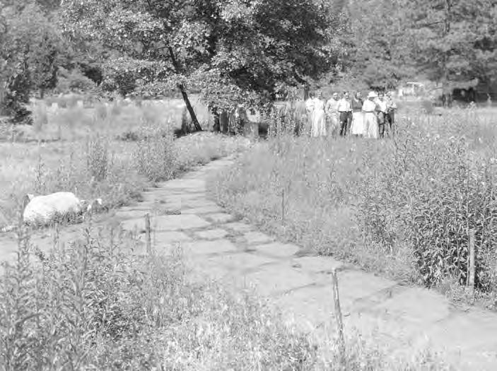
The Landscape Division of the NPS developed a plan for the garden, which was built by the CCC. The garden included flagstone walks, an area for outdoor programming, log benches, and a brook feeding a small boulder-lined lake in 1933. The soil was improved and trees and flowers were planted. 350’ of brook and two areas of lake (40’ x 20’ and 32’ x 50’) were excavated. Ten cascades were made from rock to prevent erosion. A 55” galvanized fence painted green with two 6’ pedestrian gates and a 10’ service gate enclosed the garden. Trees and shrubs transplanted from the El Capitan vicinity screened the fence. These included Manzanita, Jeffrey Pine, Cedar, Sugar Pine, Douglas Fir, Yellow Pine, Live Oak, Nutmeg, Scrub Oak, Golden Oak, Lodgepole Pine, Maple, Azalea, Gooseberry, Wild Rose, and Blackberries.2.77

1935
The CCC removed the perimeter fence, transplanted cedar trees, and improved the entrance, mounding and marking of gravesites, and new paths at Yosemite Cemetery. Large boulders were removed from Yosemite Village Plaza.2.78
Yosemite Village Cultural Landscape Report 2-32
2.77 United States Department of the Interior, National Park Service. Final Report - Landscaping Museum Area (Yosemite: Yosemite National Park, 1933).
2.78 NPS, Historic Resource Study, 839. Figure 2-31. 1933 Plan for the development of gardens behind Yosemite Museum (source: YOSE).


Chapter 2: Site History 2-33
Figure 2-32. Yosemite Museum Garden, c. 1933 (source: YOSE 87895).
Figure 2-33. Yosemite Museum Garden, c. 1933 (source: YOSE 79983).
Figure 2-34. Yosemite Museum Garden, c. 1933 (source: YOSE 87904).
Figure 2-35. Yosemite Museum Garden, c. 1933 (source: YOSE 79987).
Yosemite Park and Curry Company built an office building, Concessioner’s Headquarters, west of Concessioner Garage.2.79
A concept to expand Yosemite Park and Curry Company facilities was developed. This included parking, store and food warehouse, residences, warehouses, and garages.
The NPS developed design drawings for a 2’-0” tall stone wall along portions of Yosemite Cemetery.2.80

An updated master plan for Yosemite National Park was completed. Recommendations for Yosemite Village included road realignments, new community building to the east of Rangers' Club, auditorium addition to Yosemite Museum, and restrooms to Administration Building.
Yosemite Museum courtyard was converted to an interior space.2.81
2.79 United States Department of the Interior, National Park Service. Superintendent’s Annual Report – 1932. (Yosemite: Yosemite National Park, 1932), 20.
2.80 United States Department of the Interior, National Park Service. Proposed Cemetery Wall. (Yosemite: Yosemite National Park, 1940).

2.81 United States Department of the Interior, National Park Service. Historic Structure Report – Yosemite Museum. (Yosemite: Yosemite National Park, 2007), 21.
 Figure 2-37. Yosemite Cemetery tree planting, c. 1935 (source: NPS Gallery - 1031 Yosemite Historic Photo Collection).
Figure 2-38. Yosemite Cemetery before addition of wall, c. 1940 (source: NPS Gallery - 1031 Yosemite Historic Photo Collection).
Figure 2-37. Yosemite Cemetery tree planting, c. 1935 (source: NPS Gallery - 1031 Yosemite Historic Photo Collection).
Figure 2-38. Yosemite Cemetery before addition of wall, c. 1940 (source: NPS Gallery - 1031 Yosemite Historic Photo Collection).


Chapter 2: Site History 2-35
Figure 2-39. Olmsted's concept for the expansion of Yosemite Park and Curry Company facilities, c. 1939 (source: National Park Service, Frederick Law Olmsted National Historic Site).
1945
The Vint Plan for Yosemite Valley recommended the valley become a day use destination. The plan did not receive endorsement by Yosemite’s Board of Expert Advisors. They did not support the plan stating that Yosemite Valley was the “heart of the park” and the primary destination for most visitors.2.82
Yosemite Museum’s “wildflower garden” was reported in the Superintendent's Annual Report to have received minimum maintenance by naturalists and laborers but remained popular despite its poor condition.2.83
Twenty-four headstones were placed in Yosemite Cemetery.2.84
1949
Donohoe, Inc. built a two-story dormitory, Degnan’s Dormitory, to the north of Post Office (present-day Lost Arrow Dormitory).2.85
1950
Asphalt parking areas were built north and south of Lost Arrow Dormitory. Parking areas included a dry rock wall, large boulders to define the road and parking areas, and a floodlight for the larger parking area.2.86
1951
Foley Studio was removed and the NPS landscaped the area in October 1951.2.87
2.82 Carr, Mission 66 Modernism, 247.
2.83 United States Department of the Interior, National Park Service. Superintendent’s Annual Report – 1945. (Yosemite: Yosemite National Park, 1945), 6.
2.84 NPS, Historic Resource Study, 871.
2.85 United States Department of the Interior, National Park Service. Superintendent’s Annual Report – 1950. (Yosemite: Yosemite National Park, 1950).
2.86 United States Department of the Interior, National Park Service. Project Completion Report - Service Roads, Degnan's Dormitory. (Yosemite: Yosemite National Park, 1950).
2.87 United States Department of the Interior, National Park Service. Superintendent’s Annual Report – 1952. (Yosemite: Yosemite National Park, 1952).

Yosemite Village Cultural Landscape Report 2-36
Figure 2-40. Lost Arrow Dormitory asphalt parking with boulders to define parking, 1950 (source: NPS Gallery - 1031 Yosemite Historic Photo Collection).

Chapter 2: Site History 2-37
Figure 2-41. 1942 Master Plan for Yosemite Village (source: YOSE)
 Figure 2-42. 1954 drawing to remove the existing comfort station south of Yosemite Village Plaza, build a new comfort station east of Yosemite Museum, and increase parking (source: YOSE).
1953
Yosemite Village roads were improved and parking areas and utility lines were completed in anticipation of the future development of Degnan’s Kitchen and Village Store.2.88 2.89

Rangers’ Club fence was replaced.2.90
1954
Hazardous trees and limbs were removed in heavily utilized areas of Yosemite Valley, including Yosemite Village. Yosemite Village utility improvements continued for the proposed construction sites of DegnanDonohoe, Inc.2.91
1955
New exhibits, including the Indian Sweathouse and Indian U-ma-cha, were built in the Museum Garden.2.92

2.88 United States Department of the Interior, National Park Service. Superintendent’s Annual Report – 1953. (Yosemite: Yosemite National Park, 1953).
2.89 United States Department of the Interior, National Park Service. Superintendent’s Annual Report – 1957. (Yosemite: Yosemite National Park, 1957).
2.90 NPS, 2011 Rangers' Club HSR, 174.
2.91 United States Department of the Interior, National Park Service. Superintendent’s Annual Report – 1954. (Yosemite: Yosemite National Park, 1954).
2.92 United States Department of the Interior, National Park Service. Superintendent’s Annual Report – 1955. (Yosemite: Yosemite National Park, 1955).
Chapter 2: Site History 2-39
Figure 2-43. Yosemite Village Plaza, c. 1954 (source: NPS Gallery - 1031 Yosemite Historic Photo Collection).
Figure 2-44. Superintendent Preston and NPS Director Wirth dedicating a plaque near exhibits in Museum Garden (source: NPS Gallery - 1031 Yosemite Historic Photo Collection).
MISSION 66 AND PARKSCAPE USA DEVELOPMENT 2.93 (1956 TO 1972)
Overdevelopment and congestion within Yosemite Valley grew significantly after WWII. Park funding increased slightly but did not reflect post-war visitation numbers. Visitor facilities and services were capable of serving 500,000 annual visitors, but annual visitation had grown to 1,114,173 in 1956. Nationwide budgetary constraints coupled with the overuse of national parks, deferred maintenance, and a lack of new facilities resulted in the deterioration of park facilities. The degradation of resources reached crisis proportions.
1956
Yosemite Cemetery was closed to further burials.2.95
1957
2.94
NPS Director Conrad Wirth presented Mission 66 to modernize and expand the national park system in 1956. Mission 66 responded to continued growth at Yosemite Village by expanding visitor services, providing a visitor center to centralize services and ensure basic levels of interpretation, and alleviating congestion through infrastructure and management improvements. Mission 66 improvement of Yosemite Village included Valley Visitor Center and Theater, Degnan’s Kitchen, Village Store, and expanded parking. Northside Drive and Village Drive were realigned to alleviate congestion in the study area and allow visitors to bypass traffic associated with visitor services at Village Store and along Yosemite Village Plaza in the late 1950s.
The NPS closed Yosemite Village Plaza to vehicular traffic in 1972. This contrasted Mission 66's emphasis on modernizing roads and expanding parking and prioritized concerns associated with unrestricted access in Yosemite Valley and riots that erupted in the park in 1970. The conversion of the civic center of Yosemite National Park was symbolic and represented the park's new objective to encourage visitors to get out of their cars, use shuttles, and reduce the supply of available parking in a location increasingly overwhelmed by visitor use.
The Mission 66 Prospectus for Yosemite National Park was approved. The prospectus built upon the 1945 Vint Plan and established recommendations for roads and trails, visitor accommodations and facilities, interpretation, and facilities and personnel necessary for administration, maintenance, and protection of the park. Park authorities planned to limit facilities in Yosemite Valley to those essential for visitor use with supporting facilities for parkwide operations located elsewhere.2.96
Mission 66 projects initiated in 1957 included a new Comfort Station near the Yosemite Village Plaza and a four-stall garage for Post Office employees. The Mission 66 plan guided concessioners to make significant investments at Yosemite Village. This included Degnan’s Kitchen and Village Store. The NPS approved preliminary plans for Degnan’s Kitchen and Village Store and the architect, Eldridge Spencer, developed drawings for construction in the fall of 1957.2.97
2.93 Mission 66 includes three phases: Pre-Mission 66 (1945-1955), Mission 66 (1956-1966), and Parkscape USA (19671972). No improvements exist from the Pre-Mission 66 phase.
2.94 United States Department of the Interior, National Park Service. National Register of Historic Places NominationYosemite Valley Historic District Historic District Amendment (draft). (San Francisco: Architectural Resource Group, 2020), 6.
2.95 NPS, 1994 Yosemite Valley CLR, 2-114.
2.96 NPS, Historic Resource Study, 753, 754.
2.97 NPS, Superintendent’s Annual Report – 1957.
Yosemite Village Cultural Landscape Report 2-40


Yosemite Village Cultural Landscape Report 2-42
Historic Photographs
Architectural Resources Group | Degnan’s Restaurant and Loft
B4
Degnan’s Restaurant after completion, c.1960 (Yosemite National Park Research Library Negative Files).

Chapter 2: Site History 2-43
Figure 2-49. The map developed for the self-guided tour of Yosemite Cemetery identifies the approximate locations of gravesites, a stone wall to the north and east of the cemetery, cedar trees planted along the western boundary and portions of the northern and southern boundaries, and four redwood trees at the gravesite of Galen Clark (source: Guide to Pioneer Cemetery, 1959).
Historic Photographs
completed Village Store. The “merchandise center” included a market, clothing store, restaurant, and barbershop. The landscape surrounding the building was largely open with a few large trees. Grasses, shrubs, and small trees were planted around the building to allow for views to the building
The NPS completed Yosemite Village Plaza by-pass road and Post Office Access Road; concrete curbs, asphalt walks, and concrete walks at Village Store; concrete curbs and asphalt walks from Administration Building to Post Office; and parking areas at Degnan’s Kitchen and Village Store. Barriers were placed to define the edge of roads and parking. This included logs at Yosemite Village Plaza and Village Store and boulders to the south of Administration Building and

National Register of Historic Places
Nomination - Yosemite Valley Historic District oads and Parking, New Project


Architectural Resources Group | Yosemite Village Store B3 Yosemite Village Store after completion (view of the West Porch, looking south), c.1960 (Yosemite National Park Archives, YP&CC Collection, photographer: Philip Hyde).
Figure 2-51. Village Store entry plantings, c. 1960 (source: YP&CC Collection, photographer: Philip Hyde)
Architectural
B11 Postcard view of Village
Resources Group | Yosemite Village Store
Store, c.1960, west elevation (ARG collection).
Figure 2-52. Village Plaza by-pass road, 1956 (source: 1956 Roads and Parking Project Completion Report).

Chapter 2: Site History 2-45
Figure 2-53. Village Store Planting Plan, 1959 (Source: Yosemite Park and Curry Co.).
1960
Village Store parking was enlarged.2.105
mid 1960s
Lost Arrow Building was removed.
1967
The original entrance to Yosemite Museum was closed and the NPS established a new entrance on the east façade.2.106
Valley Visitor Center and Theater was completed. As constructed drawings indicate the south façade of the building was landscaped with large boulders and included a flagpole to the east of the main entrance, a fence marked the east perimeter of the site, and a terraced plaza with central planting and seating area designed between the building and comfort station.
1970
Yosemite Park and Curry Company built Wells Fargo Bank south of Village Store.

Hundreds gathered in the park over the Fourth of July weekend threatening violence over the Vietnam War and other antiestablishment sentiments. Riots erupted in Stoneman Meadow and spilled to nearby campgrounds and parking lots. Park officials recognized unrestricted vehicular access to Yosemite Valley contributed to the large crowds and riots and determined change was needed to control park access. They closed the eastern third of Yosemite Valley and Mariposa Grove to vehicular use and shuttled visitors to this area. This marked a shift away from the automobile-oriented focus of Mission 66 and established the basis for future changes to transportation patterns in Yosemite Village.2.107
1972
Yosemite Village Plaza was closed to all vehicles to reduce traffic. The parking areas and connecting drives remained as a space dedicated to pedestrian use.2.108
2.106
2.108
Yosemite Village Cultural Landscape Report 2-46
2.105 United States Department of the Interior, National Park Service. Superintendent’s Annual Report – 1960. Yosemite National Park. (Yosemite: Yosemite National Park, 1960).
NPS, 1994 Yosemite Valley CLR, 2-115.
2.107 Runte, Alfred. Yosemite The Embattled Wilderness. (Lincoln: University of Nebraska Press, 1990).
NPS, 1994 Yosemite Valley CLR, 2-114.
B12
Figure 2-54. Degnan's Kitchen (left) and Village Store (right). View from Village Drive, c. 1960 (source: ARG collection, 2018 Village Store HSR).
Historic Photographs
Architectural Resources Group | Yosemite Village Store
Postcard view of Yosemite Village, c.1960, Village Store at right and Degnan’s Restaurant at left (ARG collection).

Chapter 2: Site History 2-47
Figure 2-55. Grounds Development for Yosemite Valley Visitor Center and Theater As Constructed Drawing, 1969 (Source: Yosemite National Park).
CONTEMPORARY ALTERATIONS (1973 TO PRESENT)
Yosemite Village improvements initiated after the completion of Mission 66 primarily addressed resource protection, visitor congestion, and visitor services. Major improvements and modifications to the study area included the redesign of Yosemite Village Plaza as a pedestrian mall with nodes for interpretation and gathering (Village Mall), shuttle service and infrastructure, and removal of unnecessary facilities within the wild and scenic corridor of the Merced River.
1973
NPS director George Hartzog symbolically "retired" Yosemite Village Plaza on October 4, 1973. During a celebration commemorating the Centennial, pavement in front of Valley Visitor Center and Theater was jackhammered to mark the opening of the area as Yosemite Village Pedestrian Mall. The NPS hired EDAW to develop a design for Yosemite Village Pedestrian Mall. Funds for these improvements were never allocated. 2.109
1975
The NPS built a ceremonial roundhouse in Indian Village of the Ahwahnee, placed interpretive signs along the path, and developed a self-guided tour leaflet.2.110
2.109 United States Department of the Interior, National Park Service. Superintendent’s Annual Report – 1973. Yosemite National Park. (Yosemite: Yosemite National Park, 1973).
2.110 United States Department of the Interior, National Park Service. Superintendent’s Annual Report –1975. Yosemite National Park. (Yosemite: Yosemite National Park, 1975).
Yosemite Village Cultural Landscape Report 2-48
1976
The NPS relocated the sequoia round from the front of the Yosemite Museum to a location behind the Valley Visitor Center and Museum.2.111
late 1970s
The NPS completed improvements at Yosemite Cemetery, including split rail fencing, native surface paths, a new entrance and sign aligned to the north Administration Building walk, native plantings, and irrigation.
early 1980s
The NPS formalized circulation at Indian Village of the Ahwahnee with the establishment of a concrete path.


1980
The NPS approved the General Management Plan (GMP) for Yosemite National Park. Recommendations for Yosemite Village included creating a central interpretive program area framed by Valley Visitor Center and Theater and Yosemite Museum; separating interpretive and commercial services; redesigning the Yosemite Village Plaza as a pedestrian mall (Village Mall) with space for interpretation, pedestrian circulation, and shuttle stops; and limiting commercial services.2.112
Chapter 2: Site History 2-49
2.111 United States Department of the Interior, National Park Service. Superintendent’s Annual Report – 1975. Yosemite National Park. (Yosemite: Yosemite National Park, 1976), 8.
2.112 NPS, 1980 GMP
Figure 2-56. Sweathouse, c. 1980 (source: NPS Gallery - 1031 Yosemite Historic Photo Collection).
Figure 2-57. Indian Village of the Ahwahnee, c. 1980 (source: NPS Gallery - 1031 Yosemite Historic Photo Collection).

Yosemite Village Cultural Landscape Report 2-50
Figure 2-58. Development Concept for Yosemite Village from the 1990 General Management Plan for Yosemite National Park (source: YOSE).

Chapter 2: Site History 2-51 Circa 1981 (EDAW eTIC Drawing, YOSE 104-41121)
Figure 2-59. The overall concept for Village Mall included in the 1981 comprehensive design package (source: YOSE).
1981
1982
1991
Ninety percent of the work on Village Mall was completed, including paving and landscaping at Administration Building.2.114
1983
The bicycle path from Curry Village to Village Mall was built.2.115
1986
2.113
Final drawings for Village Mall were completed by the Denver Service Center (DSC). The 1981 design rehabilitated the former parking areas at Yosemite Village Plaza, Degnan’s Kitchen Parking, Village Store Parking as a linear space for pedestrians, Village Mall. Village Mall included pedestrian walkways, seating areas, extensive landscaping with native trees, shrubs, and wildflowers, and a shuttle stop with informational signage and improved accessible routes.
Implementation of the design and field adjustments were supervised by Yosemite National Park landscape architect, Don Fox, and completed by day laborers. Improvement of Village Mall was eighty-five percent complete by the end of 1981.
Yosemite Park and Curry Company replaced the landscaped area to the west of Village Store with a paved dining terrace. The terrace included exposed aggregate concrete paving, arched light fixtures, wood perimeter railings, and concrete stairs to the south of the building. Improvement also included an accessible concrete ramp to the west entry porch and new wood railings at the west entry bridges and east and west entrance porches.2.116
The sequoia round was returned to its original location in front of Yosemite Museum. Indian Village of the Ahwahnee was rehabilitated to provide an accessible walkway, seating, and landscaping.2.117
1992
The Southern Sierra Miwuk Nation and the NPS curator of ethnography planned and supervised improvements at Indian Village of the Ahwahnee, including dismantling and rebuilding the ceremonial roundhouse and building Chief’s House. 2.118
2.113 "Yosemite Village Mall Rehabilitation Correspondence, Notes and Photographs," June 15, 1981 to September 8, 1982, Series 3, Subseries A, Box 8, Folder 116, Yosemite National Park Archives, Yosemite National Park, CA.
2.114 United States Department of the Interior, National Park Service. Superintendent’s Annual Report – 1982. Yosemite National Park. (Yosemite: Yosemite National Park, 1982).
2.115 United States Department of the Interior, National Park Service. Superintendent’s Annual Report – 1983. Yosemite National Park. (Yosemite: Yosemite National Park, 1983), 4.
2.116 NPS. NRHP - Yosemite Valley Historic District Historic District Amendment (draft), 9.
2.117 The NPS removed the sequoia round from the Yosemite Museum in 1965. United States Department of the Interior, National Park Service. Superintendent’s Annual Report – 1991. Yosemite National Park. (Yosemite: Yosemite National Park, 1991), 8.
2.118 United States Department of the Interior, National Park Service. Superintendent’s Annual Report – 1992. Yosemite National Park. (Yosemite: Yosemite National Park, 1992), 7, 8, 13.
Yosemite Village Cultural Landscape Report 2-52

1993
Music Corporation of America (MCA) sold Yosemite Park and Curry Company to the National Park Foundation. The foundation donated all buildings, including Degnan’s Kitchen and Village Store, to the NPS which maintains ownership of the buildings.2.119
1995
New wayside exhibits were designed and placed in Indian Village of the Ahwahnee.2.120
1997
Lost Arrow Cabins, providing temporary housing for eighty employees, were placed in the parking lot south of Lost Arrow Dormitory.
2006
Lift Stations were built in Yosemite Village.
2008
Bus shelters were built in Yosemite Village.
2013
Yosemite Conservancy restored and repaired Yosemite Cemetery headstones and repaired damaged wrought-iron fencing and stone walls.2.121
2014
The Merced Wild and Scenic Comprehensive Management Plan and Environmental Impact Statement was completed. The plan established a framework to protect and enhance the rare and unique qualities of the Merced River and provide for high-quality visitor experiences and access throughout Yosemite Valley. Recommendations for the study area included replacing temporary Lost Arrow housing with permanent housing; removing Wells Fargo Bank, Concessioner’s Headquarters, and Concessioner Garage; re-using both the Concessioner’s Headquarters and Concessioner Garage sites for parking; and re-routing Northside Drive to the south of day use parking.2.122
after 2014
The NPS implemented Merced Wild and Scenic Comprehensive Management Plan recommendations to remove Wells Fargo Bank and Concessioner’s Headquarters and to re-route Northside Drive around a central, contiguous Visitor Parking area.
2.119 United States Department of the Interior, National Park Service and Architectural Resources Group, Inc. Historic Structures Report – Degnan’s Restaurant and Loft. (San Francisco: Architectural Resource Group, 2017), 18.
2.120 United States Department of the Interior, National Park Service. Superintendent’s Annual Report – 1995. Yosemite National Park. (Yosemite: Yosemite National Park, 1995), 27.
2.121 https://yosemite.org/impact/iconic-and-past-projects/
2.122 NPS. Merced Wild and Scenic River Final CMP, Vol 1, 8-205.
Yosemite Village Cultural Landscape Report 2-54
EXISTING CONDITION AND ANALYSIS 3
GIS Data Source: 1 ”FACILITY_Buildings_
Indian Canyon C r kee Indian Creek Road Oak Lane Lost Arrow Drive Sentinel Drive IndianCanyonRoad Castl e Cli sCourt Yosemite Museum Rangers’ Club Yosemite Cemetery Ansel Adams Gallery Indian Village of the Ahwahnee Administrative Building Post O ce Garage Valley Wilderness Center Degnan’s Kitchen Lost Arrow Cabins Lost Arrow Dormitory Residence 1 Residence 2 Residence 3 Comfort Station Valley Visitor Center and Theater Village Store Engine 7 Security/O ce Garage 1 Garage 2 Garage 3 Garage 4 Concessioner Garage Transformer Shelter Garage Lift Station Cook’s Meadow Village Drive VillageDrive Village Drive Village Drive Village Drive Ahwahnee Drive Village Drive Merced River WildandScenicRiverCorridor VillageServiceRoad NorthsideDrive TecoyaRoad Indian Canyon Creek Bridge #2 Indian Canyon Creek Bridge #3
Existing
Building or Structure Vehicular and Pedestrian Circulation Study Area Merced River Wild and
River
YOSE_py”
Base
0125250
N
Figure 3-1. Existing Condition Plan (source: Mundus Bishop, 2022).
Condition
Scenic
Corridor
Yosemite National Park, GIS; Map
Data: Yosemite National Park, GIS
feet
INTRODUCTION
This chapter presents the existing condition of the cultural landscape and analyzes integrity according to the Secretary of the Interior’s Standards seven aspects of integrity.3.1 Photographs, existing condition matrices, and illustrative analysis diagrams describe the cultural landscape through the assessment of eight landscape characteristics.
This assessment was undertaken to understand the cultural landscape as a whole, to identify and document qualities that contribute to its historic character, and to identify individual features that contribute to its significance.
Site investigations documented and evaluated existing condition using the following criteria.
• Good—Those features of the landscape that do not require treatment. Only minor or routine maintenance is needed at this time.
• Fair—Some deterioration, decline, or damage is noticeable; the feature may require immediate intervention. If intervention is deferred, the feature will require extensive attention in a few years.
• Poor—Deterioration, decline, or damage is serious; the feature is seriously deteriorated, damaged, or presents a hazardous condition. Due to the level of deterioration, damage, or danger, the feature requires extensive and immediate attention.
Chapter 3: Existing Condition and Analysis 3-3
3.1 United States Department of Interior, National Park Service. The Secretary of the Interior’s Standards for Treatment of Historic Properties with Guidelines for the Treatment of Cultural Landscapes. Washington, DC: Cultural Resource Stewardship and Partnerships, 1996.
This document evaluates the study area according to the following eight landscape characteristics that include tangible and intangible aspects. These landscape characteristics collectively create the historic character of the study area and aid in understanding its cultural significance.
• Natural Systems are natural aspects that have influenced the development and physical form.
• Archeological Sites are areas containing surface and subsurface remnants related to historic or prehistoric land use.
• Land Use is the organization, form, and shape of the land in response to land use.
• Spatial Organization is the arrangement of elements creating the ground, vertical, and overhead planes that define and create space, including topography, buildings, and vegetation.
• Views and Vistas are features that create or allow a range of vision that can be natural or designed and controlled.
• Circulation are features and materials that constitute systems of movement.
• Buildings and Structures are three-dimensional man-made constructs.
• Small Scale Features are human-scaled elements that provide detail and function.
Yosemite Village Cultural Landscape Report 3-4
Seven Aspects of Integrity3.1
Location is the place where the cultural landscape was constructed or a historic event occurred.
Setting is the physical environment of the cultural landscape.
Feeling is the cultural landscape’s expression of the aesthetic or historic sense of a particular period of time.
Materials are physical elements that were combined or deposited during the period(s) of time and in a particular pattern or configuration to form the cultural landscape.
Workmanship includes the physical evidence of the crafts of a particular culture or people during any given period in history or prehistory.
Design is the combination of elements to create the form, plan, space, structure, and style of the cultural landscape.
Association is the direct link between the important historic event or person and a cultural landscape.
3.1 NPS. The Secretary of the Interior’s Standards for Treatment of Historic Properties with Guidelines for the Treatment of Cultural Landscapes.
ASSESSMENT OF INTEGRITY
Integrity is the ability of a cultural landscape to convey its significance. The study area was assessed to determine if the landscape characteristics that shaped the cultural landscape during the period of significance are present today. Integrity is evaluated according to seven aspects or qualities: location, setting, feeling, design, materials, workmanship, and association.
The cultural landscape retains integrity in location, materials, workmanship, and association.
• The study area retains integrity in location. The physical environment associated with the development of the study area as the civic core of Yosemite National Park remains in the original location as one of the original clusters of development set within Yosemite Valley. The study area retains original relations to Northside Drive and surrounding natural features, including Merced River, Cook's Meadow, Yosemite Falls, Half Dome, granite canyon walls, and other geologic features.
• Materials, workmanship, and association of the study area’s contributing features retain the original rustic/Mission 66 aesthetic of the period of significance. Buildings, circulation features, and small scale features retain the historic material palette of wood and stone.
The cultural landscape has diminished integrity in feeling, setting, and design.
• The feeling, setting, and design of the study area are diminished by the redesign of Yosemite Village Plaza as Village Mall and mature, dense vegetation. Village Mall subdivided the originally open Yosemite Village Plaza with planting and gathering areas and converted the primary vehicular route through the study area to pedestrian use with adjacent bike and vehicular routes. This diminished the integrity of the originally open plaza, altered physical and visual relationships to natural features and buildings, and altered the original arrival sequence and feeling of arrival within the civic hub of Yosemite Valley.
Chapter 3: Existing Condition and Analysis 3-5
CONTRIBUTING AND NON-CONTRIBUTING FEATURES
Contributing features are individual elements or landscape characteristics extant from the period of significance that contribute to the cultural landscape of Yosemite Village.
Non-contributing features do not contribute to the cultural landscape because they were not present during the period of significance, do not relate to the documented significance of the property, no longer possess historical integrity, or are no longer capable of yielding important information relevant to the significance of the property.
Natural Systems and Features Contributing / Non-Contributing Contributes to Historic Character
Merced River and Riverine Corridor
Native Woodland Vegetation
Indian Canyon Creek
Village Store Waterway Non-Contributing +
Spatial Organization and Cluster Arrangement Contributing / Non-Contributing Contributes to Historic Character
Village Store and Garage Non-Contributing +
Village Services and Administrative Core
Views and Vistas Contributing / Non-Contributing Contributes to Historic Character
Views from the Plaza Area at the West of Yosemite Mall to Yosemite Point, Yosemite Falls, Half Dome, and Sentinel Rock.
Views to Cook’s Meadow, Yosemite Falls, Yosemite Point, Sentinel Rock, and Granite Walls from Visitor Services and Administrative Core
Views to and between Buildings in Visitor Services and Administrative Core
Views to Castle Cliffs, Yosemite Point, Sentinel Rock, Indian Canyon, and Moran Point from Village Store and Garage
• Contributing feature identified in 2006 Yosemite Valley Historic District National Register of Historic Places Nomination
• • Contributing feature identified in 2020 Yosemite Valley Historic District National Register of Historic Places Nomination Amendment (draft)
+ Contributes to Historic Character (feature not included in current Yosemite Valley Historic District Documentation)
Yosemite Village Cultural Landscape Report 3-6
Table 3-1. Contributing Features
Non-Contributing +
Non-Contributing
+
Non-Contributing +
Non-Contributing +
•
Non-Contributing +
Non-Contributing
+
Non-Contributing +
• Contributing feature identified in 2006 Yosemite Valley Historic District National Register of Historic Places Nomination
• • Contributing feature identified in 2020 Yosemite Valley Historic District National Register of Historic Places Nomination Amendment (draft) + Contributes to Historic Character (feature not included in current Yosemite Valley Historic District Documentation)
Table 3-1. Contributing Features (continued)
Circulation
Ahwahnee Drive
Ansel Adams Studio Parking
Ansel Adams Studio Walks
Bike Path
Concessioner Garage Parking
Degnan’s Kitchen Covered Walkway, Dining
Contributing / Non-Contributing Contributes to Historic Character
Terraces, and East and North Parking Lot •
Degnan’s Kitchen East Entry Walk
Indian Canyon Creek Bridge #2 •
Indian Canyon Creek Bridge #3 •
Indian Village of the Ahwahnee Path
Lost Arrow Dormitory Parking
Post Office Parking
Rangers’ Club Parking •
Valley Visitor Center and Theater Courtyard and Walks •
Village Administrative Road •
Village Drive •
Chapter 3: Existing Condition and Analysis 3-7
Non-Contributing +
Non-Contributing
Non-Contributing
+
Non-Contributing
Non-Contributing
•
Non-Contributing
Non-Contributing +
Non-Contributing
Non-Contributing +
•
Table 3-1. Contributing Features (continued)
Circulation (continued)
Village Mall
Village Service Road
Village Store (Grill) Dining Patio
Contributing / Non-Contributing Contributes to Historic Character
Village Store Pedestrian Paths, Footbridges, and East Parking Lot • •
Yosemite Cemetery Path
Small Scale Features
Ansel Adams Gallery Stone Walls
AAG Residence 1 (Building 901) Stone Walls
AAG Residence 3 (Building 904) Stone Walls
Yosemite Museum Sequoia Round
Yosemite Cemetery Stone Wall
Vegetation
Foundation Plantings at Study Area Buildings
Village Mall Plantings
Yosemite Cemetery Perimeter Trees
Galen Clark Sequoia Trees
Valley Visitor Center and Theater Courtyard Vegetation
Contributing / Non-Contributing Contributes to Historic Character
• Contributing feature identified in 2006 Yosemite Valley Historic District National Register of Historic Places Nomination
• • Contributing feature identified in 2020 Yosemite Valley Historic District National Register of Historic Places Nomination Amendment (draft)
+ Contributes to Historic Character (feature not included in current Yosemite Valley Historic District Documentation)
Contributing / Non-Contributing Contributes to Historic Character
Yosemite Village Cultural Landscape Report 3-8
Non-Contributing
Non-Contributing
Non-Contributing
Non-Contributing
Non-Contributing +
Non-Contributing +
Non-Contributing +
Non-Contributing +
Non-Contributing +
Non-Contributing
Non-Contributing
Non-Contributing +
Non-Contributing +
Non-Contributing +
• Contributing feature identified in 2006 Yosemite Valley Historic District National Register of Historic Places Nomination
• • Contributing feature identified in 2020 Yosemite Valley Historic District National Register of Historic Places Nomination Amendment (draft)
+ Contributes to Historic Character (feature not included in current Yosemite Valley Historic District Documentation)
7
Kitchen
1, 2, 3, and 4
Stations
Arrow Cabins
Arrow Dormitory
Office Garage
Museum
Chapter 3: Existing Condition and Analysis 3-9 Building and Structures Contributing / Non-Contributing Contributes to Historic Character AAG Residence
3 • AAG Residence
Non-Contributing Administrative Building • Ansel
• Bus Shelters Non-Contributing Comfort
• • Concessioner
• Degnan’s
• • Engine
Non-Contributing Garage
• Lift
Non-Contributing Lost
Non-Contributing Lost
• Post Office • Post
Non-Contributing Rangers’
• Rangers’ Club
• Security/Office Non-Contributing Valley
• • Village
• • Yosemite
• Yosemite
•
1 and
Residence 2
Adams Gallery
Station
Garage
Club
Garage
Visitor Center and Theater
Store
Wilderness Center
Table 3-1. Contributing Features (continued)
STUDY AREA
NATURAL SYSTEMS AND FEATURES
EXISTING CONDITION
Yosemite Village is within Yosemite Valley on the north side of the Merced River. The Merced River meanders through the meadow and riparian communities that characterize the valley floor. These communities comprise one of the largest mid-elevation meadow-riparian complexes in the Sierra Nevada. The significance of these resources is reflected in the park’s designation as a United Nations Educational, Scientific and Cultural Organization (UNESCO) World Heritage Site and the Merced River’s designation as part of the national wild and scenic rivers system.3.2
A retreating glacier created a lake in present-day Yosemite Valley 10,000 to 20,000 years ago and, for thousands of years, the Merced River carried sediment to the valley and filled with silt, alluvium, and debris from erosive canyon walls. The lake receded and left the relatively level valley floor defined by the vertical granite walls rising 1,500’ to 4,000’ in height.
3.3
Yosemite Village is set on the north side of the valley floor, at the base of an alluvial fan formed by debris from Indian Canyon Creek and Lehamite Creek. The study area is set within stands of deciduous trees, primarily black oak interspersed with ponderosa pines and incense cedars, with views to Cook’s Meadow to the southwest, Yosemite Falls to the northwest, and granite walls and geologic formations in all directions. Tributaries include Indian Canyon Creek along the eastern boundary of the study areas and a distributary channel west of Village Store. The southeastern portion of the study area is largely within the floodplain of Merced River the Wild and Scenic River Corridor of the Merced River.3.4
3.2 NPS. Merced Wild and Scenic River Final CMP, Vol 1, 5-3.
3.3 United States Department of Interior, National Park Service. National Register of Historic Places NominationYosemite Valley Historic District. (Yosemite: Yosemite National Park, 2006), 9.

3.4 The Merced River Plan/EIS established the corridor boundary for the Merced Wild and Scenic River. The boundary includes lands within a quarter-mile of the river’s ordinary high-water mark.

Yosemite Village Cultural Landscape Report 3-10
Figure 3-2. Granite walls and views to Yosemite Falls characterize the study area (source: Mundus Bishop, 2021).
Figure 3-3. Yosemite Village is set with native woodland vegetation (right) on the edge of the Cook's Meadow (left) (source: Mundus Bishop, 2021).
3-4. Natural Systems and Features Existing Condition Plan (source: Mundus Bishop, 2022).

RoyalArchCreek TenayaCreek Merced River Merced River India n Ca ny o n C r e e k Yos e m i t e C r kee Eagle C r e e k Sentinel Creek LehamiteCreek Yosemite Village Castle Cli s ! Yosemite Point ! Upper Yosemite Fall ! Lower Yosemite Fall ! Glacier Point ! Sierra Point ! Royal Arch Cascade ! Lehamite Falls ! Leidig Meadow Ahwahnee Meadow Stoneman Meadow Cook’s Meadow Indian Ridg e North Dome Eagle Peak Union Point Moran Point Basket Dome Sentinel Dome Boundary Hill Three Brothers ! ! ! ! ! ! ! ! Indian Canyon ! Natural Systems and Features Merced River Wild and Scenic River Corridor 1 100-year Floodplain (based on 1997 flood) 1 Vegetation 1 Meadow Chaparrel/Upland Herbacous Lower Montane Upper Montane GIS Data Source: National Park Service; Map Base Data: Yosemite National Park, GIS 0.51 mile N Figure
ANALYSIS OF INTEGRITY
Yosemite Valley is one of the largest mid-elevation meadow-riparian complexes in the Sierra Nevada. Its natural systems and features are important character defining features and remain from the period of significance. Merced River and its riverine corridor shaped the development and character of the study area throughout the period of significance and contribute to the cultural landscape.
Merced River and its riverine corridor informed the location of Yosemite Village. Development of the valley floor before the establishment of Yosemite National Park impacted the scenic qualities of the valley and the health of the Merced River. NPS planners and designers selected a location for Yosemite Village on the northside of Merced River where climatic and scenic conditions were more agreeable and it was less susceptible to flooding. Yosemite Village was set within oak stands to conceal development when viewed from the rim of adjacent cliffs and the floor of the valley. The historic composition of native woodlands is modified as pine and cedar trees slowly crowd out black oak trees.
The natural setting of the study area remains similar to the period of significance and continues to be the dominant influence on its development. The relationship of Yosemite Village to surrounding natural features remains.


Feature Description Condition
Merced River and Riverine Corridor River corridor ecosystem defining Yosemite Valley and the study area.
Native Woodland Vegetation
Contributing / Non-Contributing Contributes to Historic Character
Good Non-Contributing +
Native stands of trees, shrubs, and groundcover throughout Yosemite Village. Good Non-Contributing +
Indian Canyon Creek Tributary east of Village Store and Garage. Good Non-Contributing + Village Store Waterway
Distributary channel to the west of Village Store.
Good Non-Contributing +
to the period of significance with modifications to the composition of native woodland as pine and cedar trees crowd out black
views to natural features (source: top image: NPS Gallery - 1031 Yosemite Historic Photo Collection; bottom image: Mundus Bishop, 2021).
Yosemite Village Cultural Landscape Report 3-12
Table 3-2. Natural Systems and Features Contributing Features
Figure 3-5. The natural setting of the study area remains similar
oaks and dense vegetation obscures
ARCHEOLOGICAL SITES EXISTING CONDITION
Yosemite Village is within the larger Yosemite Valley Archeological District. Survey of the valley included casual reconnaissance in the early 1950s and intensive survey in 1974. The district was added to the NRHP in 1978 and is comprised of ninety-eight sites. Site CA-MRP-0056 is within the study area and is likely to be individually eligible for listing in the NRHP.3.5
Site CA-MRP-0056 was the site of multiple episodes of occupation spanning several thousands of years. Archeologists first recorded evidence of the village in the 1950s with subsequent investigation in the 1960s and after the 1980s. Archeological investigations determined occupations overlapped and each represented 50 to 200 years of use from around 2000 BCE to the late 1800s. Archeological findings include tools, projectile points, scrapers, soapstone vessel fragments, beads, glass beads, and numerous other items dating to American Indian occupation of the area. Bedrock mortars are documented at Ansel Adams Gallery.3.6
ANALYSIS OF INTEGRITY
Archeological sites indicate American Indians were present in this natural landscape for at least 4,000 years before development of Yosemite Village. Continued use and connections to the site prior to the development of Yosemite Village contribute to present-day stewardship and traditional use of the study area (e.g. black oaks, bedrock mortars, etc).
Development of Yosemite Village compromised the integrity of archeological sites. Site CA-MRP-0056 was largely destroyed or disturbed by the development of Yosemite Village. Systematic excavation of the site was conducted in 1966 by J. Rasson. Rasson determined much of the fill was disturbed to a degree that made determining provenience meaningless. The investigation was superficially recorded. Original midden likely remains in areas between buildings and roads. 3.7
Further investigation is needed to determine the location, condition, and significance of archeological features. The study area may contain significant archeological resources related to American Indian villages and nineteenth century pioneer settlements.

Chapter 3: Existing Condition and Analysis 3-13
3.5 United States Department of the Interior, National Park Service. National Register of Historic Places Nomination - Yosemite Valley Archeological District. (Yosemite: Yosemite National Park, 1976), 1.
3.6 McManamon, Francis. Archaeology in America: An Encyclopedia. (Ebook, 2008), 74.
3.7 NPS, Yosemite Valley Archeological District, 1.
Figure 3-6. Bedrock mortar at Ansel Adams Gallery (source: Mundus Bishop, 2021).
LAND USE EXISTING CONDITION
The NPS owns and manages the forty-acre study area as a major development area supporting the needs of park visitors and administration. The study area is organized by use and function. Village Services and Administrative Core includes administration, visitor, residential, and cemetery use. Village Store and Garage supports visitor services, administration, operations, and parking.
ANALYSIS OF INTEGRITY
Land use remains similar to the period of significance. The NPS continues to own and manage Yosemite Village as a major development area supporting the needs of park visitors and NPS administration.
Yosemite Village Cultural Landscape Report 3-14
Land Use
Building / Structure Use 1
Concessioner Housing
Concessioner Administration
Concessioner Visitor Services
NPS Housing
NPS Administration
NPS Visitor Services
Public/Institutional
GIS Data Source: 1 ”FACILITY_Buildings_
YOSE_py” Yosemite National Park, GIS; Map
Base Data: Yosemite National Park, GIS
0125250 feet
Chapter 3: Existing Condition and Analysis 3-15 Yosemite Cemetery Parking Yosemite Museum Rangers’ Club Ansel Adams Gallery Indian Village of the Ahwahnee Administrative Building Post O ce Valley Wilderness Center Degnan’s Kitchen Lost Arrow Cabins Lost Arrow Dormitory Valley Visitor Center and Theater Village Store Concessioner Garage Village Drive Northside Drive Village Drive Village Drive Village Drive AhwahneeRoad TecoyaRoad Indian Canyon C r kee Indian Creek Road Oak Lane Lost Arrow Drive Sentinel Drive Cook’s Meadow IndianCanyonRoad Castl e Cli sCourt
Services and Administrative Core Village Store and Garage
Visitor
Figure 3-7. Land Use Existing Condition Plan (source: Mundus Bishop, 2022).
N
SPATIAL ORGANIZATION/CLUSTER ARRANGEMENT EXISTING CONDITION
Yosemite Village is one of several well-defined clusters of development within Yosemite Valley. Yosemite Village is set within stands of deciduous trees in the meadow-riparian vegetation of the valley floor. The study area is organized into two distinct areas—Visitor Services and Administrative Core and Village Store and Garage—connected by Village Mall, walks, and a bicycle path.
Visitor Services and Administrative Core
Visitor Services and Administrative Core is arranged in a staggered grid along a central axis (Village Mall) with primary building façades oriented to Village Mall. Village Mall is oriented for views to Yosemite Falls, Yosemite Point, and Sentinel Rock. Village Mall widens from a pedestrian promenade to the east to a pedestrian mall with nodes for interpretation and large gathering spaces at the entrances of Valley Visitor Center and Yosemite Museum. Administration Building is prominently set at the terminus of Village Mall within a formally arranged space of orthogonal walks. Buildings north of Village Mall have public-facing façades oriented to the mall with a mix of administrative/operation and visitor uses, enclosed by perimeter fences. Rangers’ Club shares the orthogonal orientation of Administration Building with its primary (north) façade oriented to Administration Building and south façade oriented to Cook’s Meadow. Topography slopes from north to south with buildings to the north of Village Mall set on a rise and Rangers’ Club set below the elevation of Village Mall and Village Drive.
Village Store and Garage
Village Store and Garage is arranged along Village Drive. Concessioner Garage is oriented to Village Drive with surrounding operational buildings, parking, and walks arranged in a grid established by Concessioner Garage. Village Store is oriented to Village Mall and parking along Village Drive.
Yosemite Village Cultural Landscape Report 3-16
Chapter 3: Existing Condition and Analysis 3-17 VillageMall Village Drive Yosemite Cemetery Yosemite Museum Rangers’ Club Ansel Adams Gallery Indian Village of the Ahwahnee Administrative Building Post O ce Valley Wilderness Center Degnan’s Kitchen Lost Arrow Cabins Lost Arrow Dormitory Valley Visitor Center and Theater Village Store Concessioner Garage Village Drive Northside Drive VillageDrive Village Drive Village Drive AhwahneeRoad TecoyaRoad Indian Canyon C r kee Indian Creek Road Oak Lane Lost Arrow Drive Sentinel Drive Cook’s Meadow IndianCanyonRoad Castl e Cli sCourt Visitor Services and Administrative Core Village Store and Garage
0125250 feet N Spatial Organization Cluster of Development Primary Building Orientation Village Mall / Village Drive 2’ Contour GIS Data Source: Yosemite National Park, GIS
Figure 3-8. Spatial Organization Existing Condition Plan (source: Mundus Bishop, 2022).
ANALYSIS OF INTEGRITY
The cluster arrangement of Yosemite Village retains integrity and contributes to the historic character of the study area. Yosemite Village remains in its original location as a major development area within Yosemite Valley supporting the needs of park visitors and the NPS administration. NPS designers located Yosemite Village above the floodplain and organized the village into three concentrated areas of development by use. Each cluster was located to be conveniently next to each other but separated by vegetation, topography, and design. Historic plans called for the thoughtful selection of building sites, visual relationships between public spaces and natural features, and a hierarchy of roads. Rangers’ Club and park administration and concessioner buildings were organized around a central plaza (Yosemite Village Plaza) forming a new civic center for Yosemite National Park.

Yosemite Village Cultural Landscape Report 3-18
3.8 3.9
3.8 Residential clusters are outside of the study area of this plan. 3.9 NPS, Sense of Place, 101.
Figure 3-9. Topography slopes from north to south with buildings to the north of Village Mall set on a rise with primary façades oriented toward Village Mall. View from Administration Building east towards Post Office and Half Dome, c. 1954 (source: 1031 Yosemite Historic Photo Collection).
Visitor services and administrative uses were organized with a consistent setback along three sides of the open Yosemite Village Plaza (parking) with unobstructed views between buildings.
The organization established by Yosemite Village Plaza was extended to the southeast with the addition of Degnan's Kitchen and Village Store. Historic setbacks, views between buildings, and relationships between buildings, walks, and parking were maintained.
The redesign of Village Mall subdivided the central, open space created by Yosemite Village Plaza to establish gathering areas and separate routes for pedestrians, bicycles, and shuttles. Dense vegetation obscured views throughout the study area.
Chapter 3: Existing Condition and Analysis 3-19 Visitor Services and Administrative Core Yosemite Village Plaza Car Shed, Gas Station, Garage, and General O ce Feature Description Contributing Non-Contributing Parkingand Walk s Visitor Services and Administrative Core Village Store and Garage Yosemite Village Plaza Village Store and Garage Visitor Services and Administrative Core Village Mall Dense Vegetation
Figure 3-10. Spatial Organization Analysis (source: Mundus Bishop, 2022)
Rustic Development and New Deal (1920 to 1955) 1 1 2 3 Mission 66 Development (1956 to 1972) 2 Contemporary Alterations (1973 to present) 3
Figure 3-11. Valley Visitor Center and Theater As Constructed Drawing developed in 1969 illustrate typical Mission 66 program design principles for courtyards. This includes a courtyard defined by building walls with seating areas, planting beds, and raised planters (Source: Yosemite National Park).
locations that were not visually prominent, minimized earthwork and vegetation removal, and at park entrances, "en-route" along a major park road, or at a major destination.3.10
Mission 66 also established principles for less naturalistic and more urban plazas and courtyards. This includes plazas and courtyards at Degnan’s Kitchen, Village Store, and Valley Visitor Center and Theater. Typical of Mission 66 design, these plazas and courtyards were defined by hardscape, seating areas, planting beds, raised planters, and seating, site, and building walls.3.11
3.10 Carr, Mission 66 Era Resources Nomination, 12, 14, 30.
3.11
Carr, Mission 66 Era Resources Nomination, 16.
The spatial organization of Visitor Services and Administrative Core was altered by the redesign of Yosemite Village Plaza to Village Mall in 1982. Buildings were originally arranged around a central open space (Yosemite Village Plaza), shared a consistent setback and orientation to the plaza, included parking at primary public building entrances, and were connected by walks and open views to primary building façades. Both buildings and walks were sited to capitalize on views to natural features. Original views to buildings and natural features created a sequence through the study area and a sense of arrival at Yosemite Village Plaza. This organization remains but is modified by the redesign of the original central, unifying space (Yosemite Village Plaza). The central, unifying space was altered by the establishment of plantings and gathering areas in the originally open Yosemite Village Plaza and the reconfiguration of circulation routes and parking to separate vehicular, pedestrian, and bike use.
Chapter 3: Existing Condition and Analysis 3-21
Contributing Features Feature Contributing / Non-Contributing Contributes to Historic Character Visitor Services and Administrative Core Non-Contributing + Village Store and Garage Non-Contributing +
Table 3-3. Spatial Organization
VIEWS AND VISTAS
EXISTING CONDITION
Views and vistas from Yosemite Village orient visitors to the natural splendor of the study area. Set within stands of trees, Yosemite Village capitalizes on views without obstructing views from within and above the valley floor.
Primary views from Yosemite Village include views to Cook’s Meadow, Yosemite Falls, Half Dome, Yosemite Point, Lost Arrow Spire, Sentinel Rock, Indian Canyon, Castle Cliffs, Royal Arches, Moran Point, Glacier Point, Half Dome, and granite walls of Yosemite Valley. Mature vegetation obscures views from Yosemite Village and limits the number of vantage points where natural features can be viewed throughout the study area.
Primary views within the study area include views to and between buildings and to surrounding natural features. Mature vegetation obscures views between buildings and limits views of buildings to their immediate setting.

Yosemite Village Cultural Landscape Report 3-22
! ! ! ! ! ! ! ! ! !
Royal Arches
Glacier Point
Moran Point
Sentinel Rock
Half Dome
Yosemite Falls
Lost Arrow Spire Indian Canyon
Yosemite Point Castle Cli s
Views from Rangers’ Club to Cook’s Meadow, Sentinel Rock, and Granite Walls of Yosemite Valley
Views from Village Mall to Yosemite Falls, Yosemite Point, and Sentential Rock
Views from Village Store and Garage to Sentinel Rock and Moran Point
MercedRiver
Views from Village Store and Garage to Indian Canyon and Castle Cli s
Figure 3-12. Primary Views from the Study Area Existing Condition Plan (map source: Mundus Bishop, 2022).
Chapter 3: Existing Condition and Analysis 3-23 Yosemite Cemetery Yosemite Museum Rangers’ Club Ansel Adams Gallery Indian Village of the Ahwahnee Administration Building Post O ce Valley Wilderness Center Degnan’s Kitchen Views to Degnan’s Kitchen Views to Village Store Views to Village Store, Yosemite Point, and Castle Cli s Views to Village Mall Views to Village Mall Views to Village Mall, Yosemite Falls, Yosemite Point Views to Yosemite Falls, Yosemite Point Views to Post O ce Views to Visitor Center, Yosemite Point, Yosemite Falls Views to Sentinel Rock Views to Yosemite Falls, Yosemite Point Views to Yosemite Cemetry, Yosemite Falls, Yosemite Point Views to Yosemite Falls, Yosemite Point, Museum, Visitor Center Views to Rangers’ Club Views to Cook’s Meadow and Sentinel Rock Views to Rangers’ Club Views to Visitor Services and Administrative Core Lost Arrow Cabins Lost Arrow Dormitory Valley Visitor Center and Theater Village Store Concessioner Garage Village Drive Village Drive Village Drive AhwahneeRoad TecoyaRoad Indian Canyon C r kee Indian Creek Road Oak Lane Lost Arrow Drive Sentinel Drive Cook’s Meadow IndianCanyonRoad Castl e Cli sCourt Figure 3-13.
Views and Vistas Primary View Map Base Data: Yosemite National Park, GIS 0125250 feet N
Primary Views within the Study Area Existing Condition Plan (source: Mundus Bishop, 2022).
ANALYSIS OF INTEGRITY
The visual relationship to the natural features of Yosemite Village contributes to the cultural landscape. Views and vistas influenced the historic siting and orientation of Yosemite Village. Yosemite Village was set on a topographic rise to capitalize on views and was set within stands of trees to minimize views of the village from within and above the valley floor. Development was oriented to provide visitors with orchestrated views as they progressed through the site. Natural scenery served as a prominent backdrop to the new civic center of Yosemite National Park. Gathering areas and points of interest were intentionally sited and landscaped to provide the
sweeping vistas that assisted visitors in orienting themselves in Yosemite Valley and giving a sense of scale in association with the 3,000-foot granite backdrop. Historic views within and from the study area are diminished by mature vegetation.
The visual relationship between natural features and Visitor Services and Administrative Core contributes to the cultural landscape. Mature vegetation obscures views throughout Visitor Services and Administrative Core and limits the number of vantage points to Cook’s Meadow, Yosemite Falls, Yosemite Point, Sentinel Rock, and granite walls of Yosemite Valley. Historic views are diminished by
plantings along the historically open central plaza, Village Mall, and by foundation plantings. Vegetation obscures historic views between buildings and limits views of buildings along Village Mall to the immediate surroundings.
The visual relationship between natural features and Village Store and Garage contributes to the cultural landscape. Mature vegetation obscures views throughout Village Store and Garage and limits the number of vantage points to Castle Cliffs, Yosemite Point, Sentinel Rock, Indian Canyon, and Moran Point.
Views from the plaza area at the west of Yosemite Mall to Yosemite Point, Yosemite Falls, Half Dome, and Sentinel Rock.
Views to Cook’s Meadow, Yosemite Falls, Yosemite Point, Sentinel Rock, and Granite Walls from Visitor Services and Administrative Core
Views to and between buildings in Visitor Services and Administrative Core
Views to Castle Cliffs, Yosemite Point, Sentinel Rock, Indian Canyon, and Moran Point from Village Store and Garage
Mature vegetation obscures views and limits the number of vantage points.
Mature vegetation obscures views and limits the number of vantage points throughout Visitor Services and Administrative Core.
Mature vegetation obscures views to and between buildings.
Mature vegetation obscures views.
+
Yosemite Village Cultural Landscape Report 3-24
Feature Description Condition Contributing / Non-Contributing Contributes to Historic Character
Table 3-4. Views and Vistas Contributing Features
Fair
Contributing
Fair Non-Contributing +
Poor Non-Contributing +
Poor Non-Contributing
Historic Photographs


Chapter 3: Existing Condition and Analysis 3-25
Figure 3-14. Historic views to Post Office, Yosemite Falls, and Yosemite Point, c. 1926 are modified by dense, mature vegetation (left image source: NPS Gallery - 1031 Yosemite Historic Photo Collection; right image source: Mundus Bishop, 2021).
Figure 3-15. Historic views and entry sequence are modified by dense vegetation at buildings and along Village Mall. Village Store (right) and Degnan's Store (left), c. 1960 (left image source: ARG collection, 2018 Village Store HSR; right image source: Mundus Bishop, 2021).
Postcard view of Yosemite Village c.1960, Village Store at right and Degnan’s Restaurant at left (ARG collection).
CIRCULATION EXISTING CONDITION
Yosemite Village circulation includes a hierarchy of vehicular, pedestrian, and bicycle routes. Northside and Southside Drives form a one-way, counterclockwise loop through the floor of the valley with Northside Drive providing primary vehicular access to the study area. Bicycle paths offer primary bicycle access through the floor of the valley. Village Mall and Bike Path provide east-west access through the study areas with a secondary and tertiary network of walks and trails connecting to visitor and administrative sites throughout the study area.

Vehicular Circulation
Vehicular circulation includes roads and parking areas. Northside Drive provides primary access to the study area. The internal network of secondary roads in the study area includes Ahwahnee Road, Village Drive, and Village Service Drive. The segment of Village Drive from Degnan’s Kitchen to Rangers’ Club is administrative.
Visitors arriving by vehicle park in lots to the south and east of Village Store. Restricted administrative and operational parking is provided at Concessioner Garage, Post Office, Degnan’s Kitchen, Lost Arrow Cabins and Dormitory, Administration Building, and Rangers’ Club. Parking at Post Office, Degnan’s Kitchen, and Village Store include loading areas.
Yosemite Valley Shuttle System provides year-round shuttle service throughout the valley floor with two stops at Village Store (eastbound and westbound), one stop at Degnan’s Kitchen, and two stops to the east of Rangers’ Club (eastbound and westbound). Yosemite Area Regional Transportation System (YARTS) provides year-round service to Yosemite Valley Visitor Center and Theater.
Two vehicular bridges, Indian Canyon Creek Bridges #2 and #3, provide access across Indian Canyon Creek at Ahwahnee Road and Tecoya Road.

Yosemite Village Cultural Landscape Report 3-26
Figure 3-16. Village Drive at Administration Building, looking east (source: Mundus Bishop, 2021).
Figure 3-17. Village Drive south of Concessioner Garage, looking north (source: Mundus Bishop, 2021).
Chapter 3: Existing Condition and Analysis 3-27 Village Drive VillageDrive Village Drive Village Drive Village Administrative Road AhwahneeDrive Ahwahnee Drive Indian Canyon C r kee Indian Creek Road Oak Lane Lost Arrow Drive Sentinel Drive IndianCanyonRoad Castl e Cli sCourt VillageDrive VillageServiceRoad NorthsideDrive TecoyaRoad Yosemite Cemetery Yosemite Museum Rangers’ Club Ansel Adams Gallery Indian Village of the Ahwahnee Administration Building Post O ce Valley Wilderness Center Degnan’s Kitchen Loading Dock Loading Dock Loading Dock Lost Arrow Dormitory Valley Visitor Center and Theater Village Store Concessioner Garage P P P P P P P P P Indian Canyon Creek Bridge #2 Indian Canyon Creek Bridge #3 Pedestrian Bridge Pedestrian Bridge Pedestrian Bridge Pedestrian Bridge Circulation Primary Pedestrian Circulation Bike Path Shuttle Route Shuttle Stop Parking Map Base Data: Yosemite National Park, GIS 0125250 feet N P
Circulation Existing Condition
0125250 feet N
Figure 3-18.
Plan (source: Mundus Bishop, 2022).
Pedestrian and Bicycle Circulation
Village Mall provides primary pedestrian access from Village Store and Garage to Visitor Services and Administrative Core. The pedestrian route widens from a promenade with seating at Village Store and Garage to a wider promenade with nodes for small gatherings at Visitor Services and Administrative Core, to large pedestrian plazas at Valley Visitor Center and Theater, Yosemite Museum, and Administrative Building. Secondary walks provide access to building entrances and parallel segments of Village Drive.
Bicycle paths provide access along Ahwahnee Road, through the study area, and throughout the floor of Yosemite Valley. The delineation of bicycle and pedestrian circulation in Visitor Services and Administrative Core is unclear and contributes to conflicts and confusion between modes.
Footbridges include two to the west of Village Store and two across Indian Canyon Creek to the east of Concessioner Garage.

Yosemite Village Cultural Landscape Report 3-28
Figure 3-19. Delineation of Village Mall (left) and bike path (right) is unclear within the Visitor Services and Administrative Core and contributes to confusion between modes (source: Mundus Bishop, 2021).
Village Mall Bike Path


Chapter 3: Existing Condition and Analysis 3-29
Figure 3-20. Bike path (source: Mundus Bishop, 2021).
Figure 3-22. Gathering space along Village Mall (source: Mundus Bishop, 2021).
Figure 3-21. Village Mall with entrance walk to Ansel Adams Gallery (source: Mundus Bishop, 2021).
Figure 3-23. Walk to Yosemite Valley shuttle stop (source: Mundus Bishop, 2021).
ANALYSIS OF INTEGRITY
The overall arrangement of circulation remains from the period of significance. The hierarchy of routes defined by use, width, and material contributes to the historic character of Yosemite Village. Circulation is modified by changes in surface material, widths, barriers/curbs, use (e.g., the conversion of vehicular roads to pedestrian and bicycle), and removal of parking at building entrances.
Vehicular and pedestrian circulation is significantly modified by the rehabilitation of Yosemite Village Plaza to Village Mall in 1982. NPS designers envisioned the plaza as the center of the new civic hub of Yosemite. Yosemite Village Plaza historically provided primary east-west vehicular access through the Visitor Services and Administrative Core, parking adjacent to visitor and administrative buildings, and a point of arrival to Yosemite Village. Yosemite Village Plaza evolved throughout the period of significance with increasing demands for parking. The NPS modified parking areas to the west of Post Office and added parking spaces at Degnan’s Kitchen and Village Store during the 1950s. The NPS permanently closed the plaza to all vehicles in 1972 and saw cut portions of Yosemite
Village Plaza in 1981 to create separate routes for pedestrians, bicycles, and shuttles and establish planting and gathering spaces.
Segments of original circulation routes remain but are diminished by the establishment of Village Mall and are difficult to discern. Village Mall established planting and gathering areas within the open central plaza (Yosemite Village Plaza) and created separated vehicular, pedestrian, and bike routes within historic roads, parking areas, and walks. Village Mall also altered movement and a sense of arrival through the study area. Visitors originally drove through the study area and parked at Yosemite Village Plaza or within parking areas at primary building entrances. Today visitors arrive by shuttle or park to the south and east of Village Store and walk to destinations throughout the study area.
Vehicular Circulation
Study area vehicular routes remain similar to the period of significance with modifications to turning radii, widths, and surfacing and additions for parking to the west of Yosemite Museum and Administration Building.
The relationship of Northside Drive to the study area remains similar to the period of
significance. The alignment of Northside Drive was modified in the 1950s to bypass Yosemite Village.
The alignment, use, and relationship of historic Village Drive to the study area were modified by rehabilitation of segments as a bicycle path and shuttle route in the 1980s. Village Drive was built in 1956 as a bypass to Yosemite Village Plaza. The route established direct access from Northside Drive to Rangers’ Club for visitors to avoid traffic associated with Yosemite Village Plaza, Degnan's Kitchen, and Village Store.
Pedestrian and Bicycle Circulation
Walks to building entrances and along roads remain similar to the period of significance. Village Store is modified by the addition of the dining plaza to the west and south of the building in 1986. Walks remain similar to the period of significance with modifications to surface materials and alignments for accessibility.
Bicycle paths are non-contributing contemporary additions. The NPS repurposed Village Drive as bicycle paths in the early 1980s.
Yosemite Village Cultural Landscape Report 3-30
Yosemite Village Plaza was established as a central parking area for the new civic hub of the Park. Primary access was via Village Drive and Northside Drive.
Northside Drive was realigned to bypass Village Store and Concessioner Garage. Village Drive was realigned to bypass Yosemite Village Plaza parking and alleviate congestion associated with this parking area and new parking at Degnan's Kitchen and Village Store.
Yosemite Village Plaza was rehabilitated as Village Mall and permanently closed to vehicles. Historic parking and roads were subdivided to establish separate routes for pedestrians, bikes, and shuttles.
Chapter 3: Existing Condition and Analysis 3-31 Northside Drive Village Drive Yosemite Village Plaza NorthsideDrive Village Drive Yosemite Village Plaza Village Drive NorthsideDrive Village Mall Village Mall Rustic Development and New Deal (1920 to 1955) 1 1 2 3 Mission 66 Development (1956 to 1972) 2 Contemporary Alterations (1973 to present) 3
Figure 3-24. Circulation Analysis (source: Mundus Bishop, 2022)
Degnan's Kitchen
Road with Perpendicular Parking
Attached Sidewalk
Village Store North Footbridge
Degnan's Kitchen
Village Mall (Pedestrian)


Village Store North Footbridge


Yosemite Village Cultural Landscape Report 3-32
Figure 3-25. Walks to building entrances and materials to delineate walks similar to the period of significance. Circulation is modified by the removal of parking at buildings (top image source: NPS Gallery - 1031 Yosemite Historic Photo Collection; bottom image source: Mundus Bishop, 2021).
Figure 3-26. Historic circulation is modified by the creation of Village Mall (top image source: NPS Gallery1031 Yosemite Historic Photo Collection; bottom image source: Mundus Bishop, 2021).
Feature Description Condition
Vehicular Circulation
Contributing / NonContributing
Contributes to Historic Character
Ahwahnee Drive 20’-0” +/- wide asphalt road. Good NonContributing +
Village Drive 20’-0” +/- to 26’-0” +/- asphalt road. Good Contributing
Village Service Road 24’-0” +/- wide asphalt road. Good NonContributing
Concessioner Garage Parking
Village Store Parking
Degnan’s Kitchen Loading Dock
Post Office Parking
Lost Arrow Dormitory Parking
Rangers’ Club Parking
Ansel Adams Studio Parking
Indian Canyon Creek Bridge #2
Indian Canyon Creek Bridge #3
Asphalt parking to the east of Village Drive. Cracks and potholes throughout.
Poor Contributing
Asphalt parking to the east of Village Store. Varies Contributing
Concrete loading area to the northwest of the building. Concrete is failing.
Asphalt parking lot to the north of Post Office. Cracks and potholes throughout.
Asphalt parking lot with temporary housing. Cracks and potholes throughout.
Fourteen-vehicle asphalt parking lot bordered with large half-round logs separating it from the road.
Asphalt entry drive and parking to the north of the building. Cracks and potholes throughout.
Rough granite, low profile bridge/ culvert.
Rough granite, arched span, diagonal set bridge/culvert with low walls.
Fair NonContributing +
Poor NonContributing +
Fair NonContributing
Fair Contributing
Feature Description
Pedestrian Circulation
Village Mall Asphalt promenade from Village Store to Administration Building.
Bike Path 10'-0" +/- asphalt path. Path includes rumble strips, stop signs, and striping at intersections.
Degnan’s Kitchen Walks Exposed aggregate poured-inplace concrete with 2” by 4” redwood divider strips.
Degnan’s Kitchen East Entry Walk
Ansel Adams Studio Walks
Condition Contributing / NonContributing
Good NonContributing
Good NonContributing
Good Contributing
Contributes to Historic Character
Poor NonContributing
Good Contributing
Concrete walks and steps to the east of the building.
Asphalt walks with rustic stone steps of varying riser heights and concrete steps to east; soft surface paths with large flat boulders to west; accessible path from the west entrance to Village Mall; soft surface paths and railroad tie steps to north.
Good NonContributing
Varies Contributing
Good Contributing
Village Store (Grill) Dining
Patio
Village Store Footbridge (north)
Village Store Footbridge (south)
Village Store Concrete Walks
Indian Canyon Creek Footbridges
Exposed aggregate concrete plaza to the west with metal perimeter railings, and concrete stairs to the south.
8’-0” wood boardwalk with 42” wood handrails from Pedestrian Mall to Village Store.
24’-0” wood boardwalk with 42” wood handrails from Pedestrian Mall to Village Store.
Concrete and exposed aggregate concrete walks to the south and east.
4’-0” +/- wide wood deck with 42” wood handrails (north and south bridges). Signs of deteriorating wood.
Good NonContributing
Good Contributing
Good Contributing
Varies NonContributing
Poor NonContributing
Chapter 3: Existing Condition and Analysis 3-33
Table 3-6. Circulation Contributing Features
SMALL SCALE FEATURES EXISTING CONDITION
Small scale features in Yosemite Village primarily serve visitor and operational functions. These include regulatory and wayfinding signage, benches, picnic tables, trash and recycling receptacles, water fountains, lighting, boulders, fences, and stone seating walls.


ANALYSIS OF INTEGRITY
Small scale features are non-contributing contemporary additions serving visitor and operational functions. Historic photographs indicate small scale features during the period of significance served similar visitor and operation functions. These included boulders and logs delineating edges of roads and parking, signage, flagpoles, lighting, fences, peeled log wheel stops, low stone walls, and bicycle racks. Most of these original features are non-extant.
Extant historic small scale features from the period of significance contribute to the cultural landscape. These include Yosemite Museum Sequoia Round and Ansel Adams Gallery stone walls.3.12
3.12 Additional research is needed to determine the extent of grave markers and other features within Yosemite Cemetery that date to the period of significance.

Yosemite Village Cultural Landscape Report 3-34
Figure 3-27. Small scale features remain similar to the period of significance. This includes signage, trash receptacles, exhibits, and the Sequoia Round at Yosemite Museum (top image source: NPS Gallery1031 Yosemite Historic Photo Collection; bottom image source: Anderson Hallas, 2021).
Figure 3-28. Historic small scale features at buildings provided for visitor use and included trash cans, signage, and boulders (source: NPS Gallery - 1031 Yosemite Historic Photo Collection).
Table 3-7. Small Scale Features Contributing Features
Feature Description
Village Mall Split rail fence, bollard lighting, wayfinding signs, boulders along walks, trash and recycling receptacles, seat walls (1’-6” +/stone walls with timber caps), tree stump seating with campfire pit (south of Yosemite Museum), and benches (composite and half log).
Bike Path Wayfinding signs, peeled log barriers, and bollard lighting.
Degnan’s Kitchen Picnic tables (5’-0” by 2’-6” rectangle composite table and 6’-0” by 6’-0” by 6’-0” hexagon composite table), composite benches, concrete aggregate water fountain, boulders along walks, split rail fences along Pedestrian Mall, vertical slat fence of varying heights to the east and west of the loading dock, site identification signage, trash and recycling receptacles, newspaper boxes, phone booths, and stone-lined inlet.
Post Office Fences (picket to the east and south, split rail to the south, and worm to the north), mailbox, bike rack, boulders, bollard lighting, planter boxes at front entrance, regulatory signage, and boulders.
Valley Wilderness Center Boulder-lined path, trash cans, canister return locker, bike rack, fences (5’-10” vertical narrow slat fence with gate at Ansel Adams Gallery, 5’-0” vertical wide slat fence).
Ansel Adams Gallery and Ancillary Buildings
Ansel Adams Gallery Stone Walls
Fences (5’-8” narrow slat fence with gate, 4’-6” 6-rail worm fence), log benches, pedestrian lights, stone wall at back, grinding stone at west edge, remnant stone steps, wood retaining wall, handrails at steps, propane tank, and planter boxes at front entrance.
Stone walls to the south, east, and west of the building. Signs of erosion and missing or out of place stones.
AAG Residence 1 Stone wall to the east of the building. Missing or out of place stones.
AAG Residence 3 Stone walls to the south of the building. Missing or out of place stones.
Valley Visitor Center and Theater
Flagpole, information kiosks, interpretive signage, regulatory signage, wayfinding signage, concrete aggregate water fountain, benches, boulders, bollard lighting, pedestrian lighting, handrails, and fences (2’-8” tall single rail at south, 6’-6” narrow slat fence at loading gate).
Comfort Station Wood bench and propane tank with vertical wide slat fence screening.
Yosemite Museum Wayfinding signage, trash and recycling receptacles, sequoia stump exhibit, and cedar bark house exhibit.
Good Non-Contributing
Good Non-Contributing
Varies Non-Contributing
Good Non-Contributing
Good Non-Contributing
Good Non-Contributing
Fair Non-Contributing +
Fair Non-Contributing +
Fair Non-Contributing +
Good Non-Contributing
Good Non-Contributing
Good Non-Contributing
Yosemite Museum
Sequoia Round Sequoia Round at main entrance of Yosemite Museum.
Administration Building Bike racks, benches, key card reader, parking and regulatory signage, and wood bollards.
Good Contributing +
Good Non-Contributing
Rangers’ Club Fence (4’-8” wide slat fence), signage, dumpsters for trash and recycling, grills, and NHL Landmark bronze plaque. Varies Non-Contributing
Village Store Picnic tables (long composite tables, hexagonal composite), trash and recycling containers (single and double), water fountain, regulatory and wayfinding signage, temporary barriers, pedestrian lights, trash and recycling barriers, benches, interpretive signage, temporary barricades, vending machine, phone booths, bike rental stand, light posts, and fences.
Good Non-Contributing
Chapter 3: Existing Condition and Analysis 3-35
Condition Contributing / Non-Contributing Contributes to Historic Character
VEGETATION
EXISTING CONDITION
Vegetation throughout Yosemite Village includes mature black oak and mixed conifer trees, shrubs, and ground coverings. Mature trees are set in the immediate settings of buildings, along Village Mall, and between clusters of development. Common trees include black oak, ponderosa pine, incense cedar, white fir, lodgepole pine, black locust, and big-leaf maple trees. Village Mall plantings include vegetation native to the site and plants transplanted from other locations in the park.
ANALYSIS OF INTEGRITY
The patterns and massing of vegetation and associated spatial relationship with buildings, structures, and circulation routes remain similar to the period of significance. Historic vegetation is modified by reduced vegetation management resulting in denser, more mature vegetation and shifts in the composition of trees as pine and cedar trees slowly crowd out black oak trees.
The historic planting design of Yosemite Village followed naturalistic landscape gardening practices. The movement
encouraged the use of native species, transplanting and replanting trees and shrubs, and grouping plantings to reflect natural plant communities. Historic foundation plantings were designed to enhance building façades rather than obscure buildings. CCC enrollees planted native ferns, trees, and shrubs along building foundations. Mission 66 plantings followed a similar approach.
Historic plans and photographs illustrate less dense plantings and open views to and between buildings. Historically trees were managed for views to buildings and natural features. Historic plantings are modified by mature, dense vegetation and reduced vegetation management.3.13
Dense vegetation established within historically open areas of Yosemite Village in the early 1980s. Linear planting areas within Yosemite Village Plaza were created to separate routes for pedestrians, bicycles, and shuttles and mounded, large planting areas were established near Valley Visitor Center and Theater and Yosemite Museum to create nodes for gathering and interpretation.
Feature Description
Foundation Plantings at Study Area Buildings
Mature ferns, trees, and shrubs planted at the foundation of buildings.
Village Mall Plantings Native trees, shrubs, wildflowers, ferns, and wildflowers within planter areas to the south of Ansel Adams Gallery, Valley Visitor Center and Theater, and Yosemite Museum.
Varies Non-Contributing
Varies Non-Contributing
Yosemite Village Cultural Landscape Report 3-36
3.13 United States Department of Interior, National Park Service. A Sense of Place: Design Guidelines for Yosemite National Park. (Yosemite: Yosemite National Park, 2012), 104.
Table 3-8. Vegetation Contributing Features
Condition Contributing / Non-Contributing


Chapter 3: Existing Condition and Analysis 3-37
Figure 3-29. Historic vegetation within Yosemite Village Plaza included low vegetation and few mature trees. Historic vegetation is modified by reduced vegetation management, resulting in denser, more mature vegetation and the introduction of plantings along Village Mall (top image source: NPS Gallery - 1031 Yosemite Historic Photo Collection; bottom image source: Mundus Bishop, 2021).
Figure 3-30. The NPS rustic and Mission 66 designs maximized protection of plants native to the site (top image source: NPS Gallery - 1031 Yosemite Historic Photo Collection; bottom image source: Mundus Bishop, 2021).
YOSEMITE CEMETERY ARCHEOLOGICAL SITES
re: Archeological Sites, page 3-13.
LAND USE EXISTING CONDITION
The study area is organized by use and function. Yosemite Cemetery functions as a cemetery.
ANALYSIS OF INTEGRITY
Land use remains similar to the period of significance and contributes to the cultural landscape. Although the NPS closed Yosemite Cemetery to burials in 1956, the site retains its historic use as a cemetery.
SPATIAL ORGANIZATION
EXISTING CONDITION
Yosemite Cemetery is set at the southwest corner of Lost Arrow Drive and Village Drive. A low stone wall parallels Lost Arrow Drive and Village Drive. Split rail fencing defines the perimeter of the cemetery and pedestrian routes through the cemetery. A row of incense cedar trees delineates the cemetery to the north, south, and west. The main entrance to the Yosemite Cemetery is aligned with a walkway to Administration Building. The cemetery consists of three spaces—Euro-American gravesites along the western edge of the cemetery, Native American gravesites along the northern edge, and an open area along the eastern edge. Marked graves are loosely organized in a grid with delineation of marked gravesites ranging from simple headstones to iron fencing, to a small allee of sequoia trees.
ANALYSIS OF INTEGRITY
Yosemite Cemetery retains integrity and contributes to the historic character of the study area. The site remains in its original location with its perimeter defined by stone walls and rows of trees and organization of three distinct spaces—Euro-American gravesites, Native American gravesites, and an open area. Paths, fences, vegetation, and walls evolved throughout the period of significance.
Maps of the cemetery indicate forty-five gravesites. Additional investigation is needed to confirm the number, location, and orientation of gravesites. Previous improvements may have modified their historic organization.
Yosemite Village Cultural Landscape Report 3-38
The 1959 map developed for the self-guided tour of Yosemite Cemetery identifies the approximate locations of gravesites, a stone wall to the north and east of the cemetery, cedar trees planted along western boundary and portions of the northern and southern boundaries, and sequoia trees at the gravesite of Galen Clark. Although the map illustrates four sequoia trees at Clark's gravesite, the accompanying narrative in the guide indicates five of the original six sequoia trees Clark planted remained. The map illustrates a modification to the alignment of the stonewall at the entrance to the cemetery. The present-

Chapter 3: Existing Condition and Analysis 3-39
VIEWS AND VISTAS
EXISTING CONDITION
Primary views from Yosemite Cemetery include filtered views to Yosemite Falls and granite walls of Yosemite Valley.
ANALYSIS OF INTEGRITY
The natural scenery of the valley served as a backdrop to the historic cemetery. Historic views within and from Yosemite Cemetery are diminished by mature vegetation.
SMALL SCALE FEATURES
EXISTING CONDITION
Small scale features primarily serve visitor and memorial functions. These include an entrance sign, seating, and stone walls.
ANALYSIS OF INTEGRITY
Historic photographs indicate small scale features during the period of significance served similar visitor and memorial functions. These included fences of varying styles and materials, gravesite markers, a low stone wall, benches, weather station, and well.
EXISTING CONDITION
Yosemite Cemetery includes paths to features throughout the site. Worm fencing defines native surface paths.
ANALYSIS OF INTEGRITY
Paths through Yosemite Cemetery varied through the period of significance but retain relationships to historic site features.
Extant historic small scale features from the period of significance contribute to the cultural landscape. These include Yosemite Cemetery stone wall and gravesite markers, monuments, and iron fences.3.1
VEGETATION
EXISTING CONDITION
Yosemite Cemetery vegetation includes plants native to the site and plants transplanted from other locations in the park. Formal tree plantings include incense cedar trees delineating the south, west, and north perimeter of Yosemite Cemetery and five sequoia trees at the Galen Clark gravesite.
ANALYSIS OF INTEGRITY
Historic plantings included six sequoia trees at the Galen Clark gravesite; incense cedar trees along the west, south, and north sides of the cemetery; and incense cedar, black oak, and ponderosa pine trees planted within the open interior of the cemetery. Vegetation is similar to the period of significance with one sequoia tree missing from the Galen Clark gravesite and gaps in the perimeter tree plantings.
Yosemite Village Cultural Landscape Report 3-40
CIRCULATION
3.1 Additional research is needed to determine the extent of small scale features within Yosemite Cemetery that date to the period of significance.
Table 3-9. Yosemite Cemetery Contributing Features
Feature Description
Yosemite Cemetery Path Native surface path defined by worm fencing.
Small Scale Features Fence (worm and slat), site identification sign, and gravesite markers.
Stone Wall Rubble stone wall to the east of Yosemite Cemetery.
Yosemite Cemetery Perimeter Trees Incense cedar trees planted along the north, west, and south perimeter of the cemetery. Gaps exist where trees have died or have been removed.
Galen Clark Gravesite Sequoia Trees Five sequoia trees marking the gravesite of Galen Clark.

Condition
Contributing / Non-Contributing
Varies Non-Contributing
Varies Non-Contributing
Contributes to Historic Character
Good Non-Contributing +
Good Non-Contributing +
Good Non-Contributing +
Chapter 3: Existing Condition and Analysis 3-41
Figure 3-33. Yosemite Cemetery is defined by a row of incense cedar trees and worm fencing to the west. Gravesites are located within mature stands of sequoia, black oak, and incense cedar trees (source: Mundus Bishop, 2021).
INDIAN VILLAGE OF THE AHWAHNEE
ARCHEOLOGICAL SITES
re: Archeological Sites, page 3-13.
LAND USE
EXISTING CONDITION
Yosemite Village is organized by use and function. Indian Village of the Ahwahnee supports visitor services. These include gathering, interpretation, ceremony, limited overnight use for ceremonial events, and cultural demonstrations. The ceremonial roundhouse in Indian Village of the Ahwahnee is used by local Indian communities throughout the year for ceremonial activities.
Overnight use continues on a limited basis for ceremonial events.
ANALYSIS OF INTEGRITY
Land use evolved during the period of significance and contributes to the cultural landscape. Indian Village of the Ahwahnee was originally developed as an exhibit with reproductions of traditional structures and areas for cultural demonstrations. Indian Village of the Ahwahnee later gained cultural significance as the NPS-tribal relationship shifted and tribes began to use the space for ceremonial purposes.
Public and tribal uses of the Indian Village is blended during traditional use activities altering the historic character of this use. The type and nature of cultural demonstrations have evolved from public interpretation to cultural continuation. The re-establishment of ceremonial spaces at Wahhoga may modify future use of Indian Village of the Ahwahnee. Use will be informed by future tribal consultation.
SPATIAL ORGANIZATION
EXISTING CONDITION
Indian Village of the Ahwahnee is set to the north of Yosemite Museum. Fences define the perimeter to the west, north, and east with Yosemite Museum to the south. The site is accessed from a gate at the northwest corner, from Yosemite Museum, and from Valley Visitor Center and Theater. A U-shaped path encompasses much of the site. Picnic tables and exhibits are set within an expanse of gravel to the northwest of a waterway that bisects the site from the northeast to the southwest.
ANALYSIS OF INTEGRITY
Indian Village of the Ahwahnee retains integrity and contributes to the historic character of the study area. The site remains in its original location as an outdoor exhibit to the north of Yosemite Museum. Vegetation, water features, and the number and location of exhibits evolved throughout the period of significance. The site continues to evolve and is compatible with the historic arrangement of plantings, paths, and exhibits.
Yosemite Village Cultural Landscape Report 3-42


Village Drive Indian Creek Road IndianCanyonRoad Castl e Cli sCourt Ceremonial Roundhouse Sweathouse Chief’s House Perimeter Fence Cabin Storage Yosemite Museum Valley Visitor Center Bark Houses 1 1 2 3 2 3
CIRCULATION
EXISTING CONDITION
Indian Village of the Ahwahnee includes paths to features throughout the sites. A U-shaped exposed aggregate concrete path provides an accessible route throughout the site. The path leads to exhibits and picnic tables in the northwest corner of the site where exhibits and gathering spaces are gravel surfaced and lack formalized paths.
ANALYSIS OF INTEGRITY
Paths through Indian Village of the Ahwahnee varied through the period of significance but retain relationships to historic site features (i.e., Yosemite Museum, waterway, and exhibits). The primary routes through Indian Village of the Ahwahnee paths were historically flagstone and native surface and formed a series of stacked loops throughout the site. Historic materials were replaced with exposed aggregate concrete and simplified to one primary loop after the period of significance.
SMALL SCALE FEATURES
EXISTING CONDITION
Small scale features in Yosemite Village primarily serve visitor functions. These include wayfinding signage, interpretive signage, exhibits, seating, trash and recycling receptacles, handrails, boulders, fences, picnic tables, and a propane tank.
ANALYSIS OF INTEGRITY
Small scale features are non-contributing contemporary additions serving visitor functions. Small scale features are compatible with historic features visible in photography from the period of significance. These included seating and similar exhibits.
VEGETATION
EXISTING CONDITION
Indian Village of the Ahwahnee includes vegetation native to the site and plants transplanted from other locations in the park.
ANALYSIS OF INTEGRITY
The NPS originally established a small outdoor exhibit in 1929 in the area that would become Indian Village and expanded the area as Yosemite Museum Gardens in the 1930s. The NPS Landscape Division designed the garden to feature the flora of the lower regions of the park with curvilinear flagstone walks and a boulder-lined lake. Plant material was transplanted from the park and included Manzanita, Jeffrey Pine, Cedar, Sugar Pine, Douglas Fir, Yellow Pine, Live Oak, Nutmeg, Scrub Oak, Golden Oak, Lodgepole Pine, Maple, Azalea, Gooseberry, Wild Rose, and Blackberries. The garden evolved to include exhibits of American Indian buildings historic to the region and vegetation continued to mature throughout the period of significance. Indian Village of the Ahwahnee continues to highlight native vegetation of the park with plant material likely dating to the period of significance.
Yosemite Village Cultural Landscape Report 3-44
Feature Description Condition
Contributing / Non-Contributing Contributes to Historic Character Indian Village of the Ahwahnee Mortars
Bedrock mortars at Indian Village of the Ahwahnee. One bedrock mortar was relocated to Indian Village of the Ahwahnee as an exhibit and is not in its original location.
U-shaped exposed aggregate concrete path. Concrete at culvert crossings and along portions of the path are in poor condition.
Small Scale Features Wood benches (with and without backs), wood slat fence, split rail fence, interpretive signage, boulders along paths, handrails, and exhibits (cedar bark houses, a Miwuk cabin, chief’s house, sweathouse, and a ceremonial roundhouse).

Varies Non-Contributing
Good Non-Contributing + Indian Village of the Ahwahnee Path
Good Non-Contributing
Chapter 3: Existing Condition and Analysis 3-45
Figure 3-35. Indian Village of the Ahwahnee path to bark houses lined with boulders, benches, and interpretive signage. Perimeter fences along the site screen views to adjacent operations uses and roads (source: Mundus Bishop, 2021).
Table 3-10. Indian Village of the Ahwahnee Contributing Features
VALLEY VISITOR CENTER AND THEATER COURTYARD ARCHEOLOGICAL SITES
re: Archeological Sites, page 3-13.
SPATIAL ORGANIZATION
EXISTING CONDITION
Valley Visitor Center and Theater Courtyard (courtyard) is defined by the visitor center building that curves around the courtyard to the north, south, and east. The western perimeter of the courtyard is open with views across Indian Village of the Ahwahnee to Yosemite Falls and Yosemite Point.
Terraced walks parallel the façade of the building and step up from the lower elevation of the lobby to the higher elevations of the east and west auditoriums. The walks define an irregularly shaped central planting area set at an elevation between the lobby and auditoriums. Boulders, mature trees, and low shrubs are set in the central and north planters. Benches are set parallel to walks and the building façades.
The courtyard is arranged with direct physical and visual access to Indian Village of the Ahwahnee, Comfort Station, and Valley Visitor Center and Theater. Doors from the courtyard provide direct access to the lobby, east auditorium, and west auditorium.
A sloped walk with low concrete walls extends north from the courtyard to two small terraces at the west auditorium and to the service entrance.
ANALYSIS OF INTEGRITY
Courtyard retains integrity and contributes to the historic character of the study area. Courtyard remains in its original location as an open courtyard at the center of Valley Visitor Center and Theater. The original terraced walks, central planter, and northern planter remain from the period of significance with historic physical connections to the interior of the building, Indian Village of the Ahwahnee, Comfort Station, and historic visual connections to Yosemite Falls, Yosemite Point, and Sentinel Rock.
VIEWS AND VISTAS
EXISTING CONDITION
Primary views from the courtyard include views across Indian Village of the Ahwahnee to Yosemite Falls and Yosemite Point to the north. The window walls to the south of the courtyard provide views through the building to Cook's Meadow and Sentinel Rock.
ANALYSIS OF INTEGRITY
Historic views from the courtyard remain and contribute to the cultural landscape. Mature vegetation obscures historic views to surrounding natural features.
Yosemite Village Cultural Landscape Report 3-46
Chapter 3: Existing Condition and Analysis 3-47
Figure 3-36. Grounds Development for Yosemite Valley Visitor Center and Theater As Constructed Drawing, 1969 (Source: Yosemite National Park).
CIRCULATION
EXISTING CONDITION
Courtyard circulation includes wide steps and walks with handrails forming the central courtyard space and a ramp with a low wall and wood handrails to the north entrances.
ANALYSIS OF INTEGRITY
Original walks, including exposed aggregate walks, curbs, and steps, remain from the period of significance and contribute to the cultural landscape. Original circulation to the west auditorium was modified by the conversion of the northernmost walkway and steps to an accessible ramp.

SMALL SCALE FEATURES
EXISTING CONDITION
Small scale features include boulders, benches, trash and recycling receptacles, and a concrete seating wall along the terrace north of west auditorium.
ANALYSIS OF INTEGRITY
Small scale features are non-contributing contemporary additions serving visitor functions. Small scale features are compatible with historic features visible in photography from the period of significance.
VEGETATION
EXISTING CONDITION
Courtyard vegetation includes plants native to the site and plants transplanted from other locations in the park. This includes black oak and western white oak trees, manzanita, and native shrubs and grasses.
ANALYSIS OF INTEGRITY
Mature vegetation native to the site informed the historic design of the courtyard. Mature trees were protected and incorporated in the design of the central planter area and terraced walks where steps were built around a mature black oak tree. The number and location of trees reflect historic as constructed courtyard drawings. A stump marks the location of a mature tree original to the central planter design.
Yosemite Village Cultural Landscape Report 3-48
Figure 3-37. Terraced walks defined the central planter (source: Mundus Bishop, 2021).
(source:
Feature Description
Views to Yosemite Point, Yosemite Falls, Cook's Meadow, and Sentinel Rock from Courtyard
Views
Point
Courtyard Walks Wide exposed aggregate concrete steps with metal handrails forming the center of the courtyard and exposed aggregate concrete ramp with wood handrails to north entrances.
Small Scale Features Wood benches (with and without backs), boulders, trash and recycling receptacles, and a concrete seating wall along the terrace north of west auditorium.

Vegetation Plants native to the site and transplanted from other locations in the park including black oak, western white oak, and incense cedar trees, manzanita, and native shrubs and grasses.

Condition
Contributing / Non-Contributing Contributes to Historic Character
Good Non-Contributing +
Good Contributing
Good Non-Contributing
Good Non-Contributing +
Chapter 3: Existing Condition and Analysis 3-49
Table 3-11. Valley Visitor Center and Theater Courtyard Contributing Features
north to Yosemite
and Yosemite Falls. Views south through the window walls of the building to Cook's Meadow and Sentinel Rock.
Figure 3-38. Terraced walks with metal handrails built around a black oak tree from the period of significance
Mundus Bishop, 2021).
Figure 3-39. Ramp to terraces to upper terraces at west auditorium (source: Mundus Bishop, 2021).
BUILDINGS AND STRUCTURES
INTRODUCTION
Yosemite Village buildings and structures include fifteen buildings designed in the NPS rustic style. These include Rangers’ Club, Rangers’ Club Garage, Administration Building, Yosemite Museum, Post Office, Ansel Adams Gallery, AAG Residence 1, Valley Wilderness Center, Lost Arrow Dormitory, Engine 7, Concessioner Garage, and Garages 1, 2, 3, and 4. Four Mission 66 designed and built structures were added during the 1950s and 1960s. These include Valley Visitor Center and Theater, Degnan’s Kitchen, Village Store, and Comfort Station. Buildings added after 1973 include Lost Arrow Cabins, Security/Office Building, and Lift Stations and Bus Shelters.
Buildings identified as contributing features date to the period of significance; retain original configuration and materials; and retain integrity of location, setting, design, materials, workmanship, association, and feeling.
This CLR provides high level condition assessments. Detailed condition assessments are included in existing Historic Structure Reports.
NPS Rustic Style Design Approach
Early buildings within Yosemite Village were designed in the park rustic style, developed specifically by NPS architects and landscape architects for the national parks.
The NPS designers instituted a cohesive design aesthetic based on the use of on-site materials and a unified architectural style adapted to climate and conditions to create a unified built form appropriate to individual surroundings. Albert H. Good defined this in his 1938 Park and Recreation Structures, “Successfully handled, it is a style which, through the use of native materials in proper scale, and through the avoidance of severely straight lines and over-sophistication, gives the feeling of having been executed by pioneer craftsmen with limited hand tools. It thus achieves sympathy with the natural surroundings and the past.”
The park rustic style emphasized scaling buildings to correlate with the surrounding landscape – larger scale in areas with large trees and smaller scale in areas with smaller trees while still designing buildings that had a sense of mass. The park rustic design style focused on blending with the environment, generally by using surrounding natural materials for the exterior façade. Design techniques, including battered stone walls and rough rock footings, were implemented on some buildings to provide the appearance of growing from the earth.
Mission 66 Design Approach
Mission 66 was the NPS’ mid-century initiative (1950s to early 1970s) for planning, landscape, and architecture implemented in national parks across the country. This initiative addressed the increased number of visitors in the parks and changes required by the introduction of car tourism.
Rather than relying on the organic forms found in rustic design, Mission 66 buildings were typically low profile with an emphasis on horizontal lines. Limited ornamentation, use of modern materials, such as concrete masonry unit (CMU) and concrete, and exterior finish materials informed by the building's surroundings were common design practices.
Yosemite Village Cultural Landscape Report 3-50
Chapter 3: Existing Condition and Analysis 3-51 Village Drive Northside Drive Village Drive Village Drive Village Drive AhwahneeRoad Indian Canyon C r kee Indian Creek Road Oak Lane Lost Arrow Drive Sentinel Drive IndianCanyonRoad Castl e Cli sCourt Yosemite Museum (1925) Rangers’ Club (1920) Yosemite Cemetery Ansel Adams Gallery (1925) Indian Village of the Ahwahnee Administrative Building (1924) Post O ce (1924) Garage (1958) Valley Wilderness Center (1925) Degnan’s Kitchen (1958) Lost Arrow Cabins (1997) Lost Arrow Dormitory (1949) AAG Residence 1 (1920s) AAG Residence 2 (1920s) AAG Residence 3 (1920s) Comfort Station (1957) Valley Visitor Center and Theater (1967) Village Store (1959) Engine 7 (1950s) Security/O ce Garage 1 (1922) Garage 2 (1922) Garage 3 (1922) Garage 4 (1922) Concessioner Garage (1922) Transformer Shelter (1920) Garage (1920) Lift Stations
Buildings and Structures Building Use1 Contributing Building Non-Contributing Building GIS Data Source: 1”FACILITY_Buildings_ YOSE_py” Yosemite National Park, GIS; Map Base Data: Yosemite National Park, GIS 0125250 feet N
Figure
3-40.
Buildings Existing Condition Plan (source: Mundus Bishop, 2022).
Principles of NPS Rustic and Mission 66 Building Design and Relationship to the Landscape
Horizontality is a key part of the design of NPS rustic buildings, intended to harmonize with their surroundings. This style also typically utilized decorative detailing and elements, such as wood brackets or mouldings. Use of native materials with different textures, along with purposeful materials and design created compatibility with the surrounding landscape. These design elements and materials provided visual interest to the exterior of the buildings which could be seen from the circulation paths when the buildings were first constructed. In the 1920s and 1930s, there was generally more limited vegetation around the buildings, allowing for views to and from buildings along main pathways. Windows in these buildings were typically smaller punched openings in each room which provided views to the surrounding landscape.
Mission 66 era buildings are simpler overall than the earlier NPS rustic buildings but have careful details, such as the soffit board design at the Visitor Center, and intentional transition between materials that provides an overall polished appearance. Mission 66 buildings are typical of the 1950s and 1960s design era with an emphasis on modern materials including concrete and large areas of glazing. These buildings, like the rustic style, were designed to harmonize with their surroundings, but in a different way. They employed simpler details, with an emphasis on clean lines, in addition to the use of modern materials to achieve a modern look that responded to the building surroundings. Materials were still informed by the surrounding landscape but in a more streamlined manner. Large, glazed openings utilized in many visitor buildings provide expansive views of the surrounding landscape, in some cases from grade to roof level.
Yosemite Village Cultural Landscape Report 3-52
Rangers’ Club (1920) –YOSE Building Number 56
Rangers’ Club was built with funds donated by Stephen T. Mather for the park's rangers and currently provides housing for NPS staff. Rangers' Club is designed in the NPS rustic style.


Rangers' Club is a two-story building, U-shaped in plan, with a steeply pitched roof, shed dormers, small balconies at the second floor, and a main entrance in the central courtyard.
Exterior materials are primarily wood and stone and include stone foundation and chimney, saw-cut wood shingle siding, wood shingle roofing with exposed rafters, exposed log beams, and rough wood board and batten siding at gable ends. Gable ends and balcony railings are cut in a decorative Swiss Chalet style pattern.
The building generally retains its original appearance. Exterior wood stairs were added to each of the wings in 1947. The building is generally in good to fair condition. Areas of exterior wood deterioration and prior repairs are visible.
Rangers’ Club Garage (1920) –YOSE Building Number 215
Rangers' Club Garage is designed in the NPS rustic style matching Rangers' Club finishes and retains its original use as a garage for Rangers' Club.
Rangers' Club Garage is a one-story building, irregular in plan, with a steeply sloped cross-hipped roof. Doors are located on the west and north elevations.
Exterior materials include saw cut wood shingle siding, wood board and batten siding, wood shingle roofing with exposed rafters, and rough wood board and batten siding at gable ends.
The building is generally in good to fair condition, with deterioration on wood shingles at grade.
Chapter 3: Existing Condition and Analysis 3-53
Figure 3-41. Rangers' Club - View to the center courtyard (source: Anderson Hallas, 2021).
Figure 3-42. Rangers' Club Garage - Wood shingle siding and board and batten finishes (source: Anderson Hallas, 2021).
Garage 1 (1922)
Built as a garage, Garage 1 currently provides storage and office space.
Garage 1 is a one-story building, rectangular in plan, with a saltbox roof. Doors are located on the front elevation with windows spaced along the back and side elevations.
Exterior materials include wood shingle siding and diagonal wood board garage doors.
The front elevation was modified to create the appearance of original diagonal wood board garage doors. Doors are fixed in place with hardware removed. One door remains accessible for pedestrian entry. The building is generally in fair condition with the siding and diagonal boards deteriorating at grade.
Concessioner Garage (1922)
Built as a garage, Concessioner Garage was designed to allow cars to drive through the building. Concessioner Garage currently serves as a bus and concessioner's fleet maintenance building.3.1
Concessioner Garage is a one-story building with a steeply sloped hip and valley roof with exposed rafters and several shed and low slope roofs on the back of the building. The building has tall, narrow windows, overhead garage doors, and pedestrian doors.


Exterior materials include wood shingle siding, vertical board and battens, wood divided lite windows, a small area of brick, wood shingle roofing, and aluminum and wood sash windows.
Concessioner Garage is modified with many historically incompatible additions and repairs clad in different finishes than the historic. Its original appearance is modified especially on the back elevation, but the primary elevation is generally intact. Concessioner Garage is in fair condition with deteriorated wood in areas.
Yosemite Village Cultural Landscape Report 3-54
3.1 Concessioner Garage has several historic names, including Curry Garage, Valley Garage, and Yosemite Transportation Service Garage.
Figure 3-43. Garage 1 - fixed garage door openings with pedestrian doors (source: Anderson Hallas, 2021).
Figure 3-44. Concessioner Garage - primary elevation with wood single siding and wood shingle roofing (source: Anderson Hallas, 2021).
Garage 2, 3, and 4 (1922)
Garages 2, 3, and 4 originally served as garages and are currently used for storage.
Garages 2, 3, and 4 are one-story buildings, rectangular in plan, with saltbox roofs; wood, bi-fold, top hung garage doors on the front elevations; and six lite windows on the back elevation.
Exterior materials include wood shingle siding.
Garages are in poor condition. Significant waves in rooflines exist and many doors are deteriorating and cannot be fully closed. Garage 4 siding is deteriorated at grade and its roof has significant biological growth.

Administration Building (1924) –YOSE Building Number 575
Administration Building retains its original use as park administration offices. The building is designed in the NPS rustic style and retains its original appearance. Administration Building is a two-and-a-halfstory building, rectangular in plan, with a moderately pitched gable roof; a portico with a casement window, transaction counter, and series of doors on the east elevation; and an egress stair from the third floor on the north elevation.

Exterior materials include granite rubble masonry cladding with recessed mortar joints at the first story, shingle siding at the second story, stone and log entry portico, log belt course and outlookers, wood shingle roofing with exposed rafter tails, wood gable end brackets, and wood doors.
Modifications include a reflective exterior storm sash and window-mounted air conditioning units. These detract from the original character of the building and conceal the divided lite configuration of the windows. The building is generally in good condition.
Chapter 3: Existing Condition and Analysis 3-55
Figure 3-45. Garage 2, 3, and 4 - waving in roof and doors that do not fully close (source: Anderson Hallas, 2021).
Figure 3-46. Administration Building - east portico (source: Anderson Hallas, 2021).
Post Office (1925)
Post Office retains its original use as a post office. The building is designed in the NPS rustic style and retains its original appearance. Post Office is a two-and-a-half story building, rectangular in plan, with a moderately pitched gable roof. Wide steps lead to three sets of double door openings on the south elevation, with a twelve-light transom spaced above the doors. The north elevation includes a porte-cochère, the west elevation includes a single door, gable ends of the building include small metal balconies on the second floor.

Exterior materials include granite rubble masonry cladding with recessed mortar joints at the first story, shingle siding at the second story, stone and log entry portico, log belt course, wood shingle roofing with exposed rafter tails, wood gable ends brackets, wood doors, and wood sash windows.
Modifications include modern, noncompatible door replacements along the north elevation. Post Office is in good condition. Moss is growing on stone along the north elevation, and areas of mortar repointing and wood deterioration are visible.
Ansel Adams Gallery (1925) –YOSE Building Number 900
Ansel Adams Gallery, known as Best's Studio until 1972, retains its original use as a studio and residence. Ansel Adams Gallery is designed in a mix of NPS rustic and Mission 66 styles. Ansel Adams Gallery is a series of one-story hipped roof buildings stepping up the hillside with a flat roof at the south elevation of the building. A walkway connects the buildings along the west elevation.
Exterior materials include paired wood columns capped by metal with a turquoise finish, wood glulam beams, stone chimney, wood shingle siding and shakes, stucco and glazing, painted plywood and battens, wood doors, wood shingle roofing, and metal fascia and asphalt shingle roofing.

Yosemite Village Cultural Landscape Report 3-56
Ansel Adams Gallery is in good condition.
Figure 3-47. Post Office - south elevation (source: Anderson Hallas, 2021).
Figure 3-48. Ansel Adams Gallery - primary entrance (source: Anderson Hallas, 2021).
AAG Residence 1 (1920s) – YOSE Building Number 902
AAG Residence 1 retains its original residential use. AAG Residence 1 is a one-story building, square in plan, with a gable roof, divided lite, wood windows, and a porch along the south elevation.
Exterior materials include wood shingle siding and wood shingle roofing with exposed rafter tails.
Modifications include replacement of historic windows. The building is generally in good condition with areas of deteriorating wood.
AAG Residence 2 (1920s) – YOSE Building Number H50
AAG Residence 2 retains its original residential use. AAG Residence 2 is a one-story building, irregular in plan, with a cross hipped roof, and covered porch at the main entry.
Exterior materials are vertical board and batten siding, horizontal wood shiplap siding, aluminum sash in wood frame windows, and asphalt shingle roof.


Exterior finishes are in fair condition with deterioration visible at the shiplap siding and peeling paint throughout.

AAG Residence 3 (1920s) – YOSE Building Number 904
AAG Residence 3 retains its original residential use. AAG Residence 3 is a one-story building, irregular in plan, with a cross hipped roof, and raised wood porch to the southeast.
Exterior materials include wood shingle siding, stone chimney, wood divided lite windows, aluminum sash windows, and asphalt shingle roofing with exposed rafter tails.
Exterior finishes are generally in good condition.
Chapter 3: Existing Condition and Analysis 3-57
Figure 3-49. AAG Residence 1 - Wood shingle siding and shingle roofing (source: Anderson Hallas, 2021).
Figure 3-50. AAG Residence 2 - Board and batten siding and horizontal siding on the Residence (source: Anderson Hallas, 2021).
Figure 3-51. AAG Residence 3 - Wood shingle siding, divided lite windows and asphalt shingles (source: Anderson Hallas, 2021).
Yosemite Museum (1925) –YOSE Building Number 576
Yosemite Museum retains its original use as a park museum. The building is designed in the NPS rustic style and retains its original appearance. Yosemite Museum is a twostory building, rectangular in plan, with a moderately pitched gable roof. Each wing of the building is slightly offset from the main, center portion of the building. An enclosed loggia extends along most of the north elevation at the first floor, with a log portico with a gable roof extending from the elevation. An arched stone opening frames double doors at the south elevation.
Exterior materials include granite rubble masonry cladding with recessed mortar joints at the first story; wood shingle siding at the second story; wood shingle roofing with exposed rafter tails and brackets; stone chimney; vertical wood plank doors with heavy metal straps; and wood casement windows.
Yosemite Museum is in fair to good condition. Areas of deteriorated wood and insect boring are visible.
Yosemite Wilderness Center (1925) – YOSE Building Number 1005
Yosemite Wilderness Center, originally Boysen Studio, was built as an artist studio. Today the building serves as the Valley Wilderness Center. The building is one story with a gable roof with a small hip at the front elevation designed in the NPS rustic style.


Exterior materials include engaged bark log columns with wood shingle siding, partially exposed log roof structure at gable ends, log trim at window and door openings, and wood shingle roofing with a log ridge cap.
Modifications include large, undivided panes of glass along the primary elevation, a modern main entrance door, and a modern door and aluminum horizontal sash along the back elevation. These modifications are not in keeping with the historic character of the building but were installed in original openings and are irreversible. Yosemite Wilderness Center is generally in good condition.
Yosemite Village Cultural Landscape Report 3-58
Figure 3-52. Yosemite Museum - south elevation with typical finishes and offset wing to the west (source: Anderson Hallas, 2021).
Figure 3-53. Yosemite Wilderness Center - primary entrance (source: Anderson Hallas, 2021).
Lost Arrow Dormitory (1949) –YOSE Building Number 918
Lost Arrow Dormitory retains its original residential use. Lost Arrow Dormitory is a two-story, rectangular in plan building with a gable roof. The main roof extends to the south to cover the south stair and entry and extends to the north to provide a protected north entry.
Exterior materials include horizontal wood siding on the first story, vertical board cladding on the second story, asphalt shingle roofing with exposed rafters, aluminum sash windows, and hollow core doors.
Lost Arrow Dormitory is in fair condition with extensive cabling attached to and penetrating the exterior walls and areas of wood deterioration and peeling paint.
Engine 7 (1950s)
Engine 7 retains its original garage use. Engine 7 is a one-story building with a gable roof.
Exterior materials include board and batten siding, wood paneling (along the addition), aluminum sash in wood frame windows, and three-panel wood door.
The building was modified by an addition to the west end of the building. Removal of this non-compatible addition would return the building to the original configuration. The building is in good to fair condition with wood siding deterioration at grade.

Chapter 3: Existing Condition and Analysis 3-59
Figure 3-54. Lost Arrow Dormitory - horizontal wood siding up to second floor window sills and vertical siding above (source: Anderson Hallas, 2021).
Figure 3-55. Engine 7 - Taller addition at the west end of the building (source: Anderson Hallas, 2021).
Degnan’s Kitchen (1958)
Degnan’s Kitchen retains its original use as a restaurant. Degnan’s Kitchen is designed in the Mission 66 style. It is a two-story building, complex shape in plan, with two A-framed volumes along the western half of the building. The primary entry doors are located along the west elevation where ten diagonal beams of the A-frame roofline create a covered walkway/dining area. A full-height, steel frame window fills the A-frame opening along the south elevation, and a concrete wall with restaurant signage extends from the face of the building along the south entry walk. A low, one-story mass extends along the east elevation with access to the loading dock to the east.
Exterior materials include steel, wood, and glass—redwood vertical siding, fixed plate glass windows, glazed entrance doors, exposed steel structure, board-formed concrete piers, ribbed wood soffits at eave overhangs, asphalt shingle roofing on A-frame roofs, rolled roofing on flat-roofed and shed-roofed surfaces, and two iron panel chimneys.

Modifications include the removal of windows with the installation of an elevator at the building’s southwest corner in 2011, removal of original wood shake roof cladding (date unknown), and installation of two vented gable dormers on the east side of the principal A-frame roof (date unknown).
The building is generally in good condition, with select areas in poor condition. Insect boring of wood is evident, particularly along the north elevation, and drainage issues occur at the loading dock.3.2
Post Office Garage (1958) –YOSE Building Number 592
Post Office Garage retains its original use as a garage. Post Office Garage is a one-story building, rectangular in plan, with a gable roof and overhead garage doors spaced along the south elevation.
Exterior materials include horizontal wood siding with chamfered edges, exposed concrete foundation, and wood shingle roofing.
The building is generally in good condition.
3.2 Refer to the 2017 Historic Structure Report for Degnan’s Restaurant and Loft for additional information.

Yosemite Village Cultural Landscape Report 3-60
Figure 3-56. Degnan's Kitchen - glazing at the south A-frame wall (source: Anderson Hallas, 2021).
Figure 3-57. Post Office Garage - horizontal board siding and garage doors (source: Anderson Hallas, 2021).
Comfort Station (1958) –YOSE Building Number 445
Comfort Station retains its original use as a comfort station. Its low slope roof, transom windows, and modern finishes are typical of Mission 66 comfort stations.
Comfort Station is a one-story building with a low slope roof, ribbon windows along long elevations, and entrances to the men’s and women’s restrooms on the south side of the building with a privacy wall and sliding door. A wall enclosing a mechanical unit connects the Comfort Station to the adjacent Museum with a gable roof enclosure.
Exterior materials include vertical wood board and battens with plywood at the gable ends, wood shingle roofing, and gable composed of glazing in wood frame.


Modifications are compatible with the original building. The building is in fair condition with areas of significantly peeling paint and deteriorated wood.
Village Store (1959)
Village Store visitor service and administrative uses are similar to original uses. Village Store is designed in the Mission 66 style. It is compound in plan,
comprised of one- and two-story buildings with four low-pitched gable roofs. Village Store is set at the center with the Employee Services wing to the north and the Food Services wing to the south. Two-story gabled entry porches are located along the east and west elevations of Village Store.
Exterior materials include horizontal and vertical wood siding, board formed concrete walls, asphalt shingle roofs with exposed wood roof beams at east and west elevations, horizontal bands of wood sash windows, concealed columns clad in tongue-and-groove siding, wood board finish soffit, and timber beams.
Modifications include infill of windows with air conditioning units and metal vents, removal of the original entry door at the north store entrance, and an addition to the north of the main entrance on the east elevation with three metal roll up doors, mechanical space, and brick chimney. 2022 modifications included the addition of doors to the southern prow. This altered the primary entrance of the building and introduced an exterior welcome plaza.
The building is generally in good condition.
Chapter 3: Existing Condition and Analysis 3-61
Figure 3-58. Comfort Station - glazing at gable end with modern shed addition (source: Anderson Hallas, 2021).
Figure 3-59. Village Store - south window wall (source: Anderson Hallas, 2021).
Valley Visitor Center and Theater (1967) – YOSE Building Number 598

Auditorium and visitor center uses are similar to original uses with modifications to historic auditoriums for theater use. It is designed in the Mission 66 style with materials selected to blend with the NPS rustic style of adjacent buildings. Valley Visitor Center and Theater is a one-story building, compound in plan, with a series of low-pitched roofs. The east and west auditoriums, exhibition hall, lobby, and retail and information areas curve around a central courtyard with a covered walkway to the north. The main entrance to the building is located in the center of the south façade, sheltered by a segmented canopy roof.
Exterior materials include concrete panels with stone veneer, cast concrete panels with smooth board-formed finishes, woodframed window walls, wood shiplap siding, decorative wood soffits, glazed aluminum doors with fixed wood sash transoms, and unglazed metal-clad doors.
The building is generally in good condition with isolated areas of wood deterioration, peeling paint, and damage or significant biologic growth caused by poor drainage.
Lost Arrow Cabins (1997) –YOSE Building Numbers 99 to 144

Lost Arrow Cabins are modern, temporary buildings with simple exterior finishes— vertical wood siding, asphalt shingle roofing, vinyl sash windows, and hollow metal doors.
Security / Office (by Firehouse) (after 1973)
Security / Office is a small building with wood shiplap siding and gable roof. A small gable roof extends over the building entrance. Exterior finishes are simple— hollow core door, asphalt shingle roofing, and aluminum sash windows.
Lift Stations (2006)
Exterior finishes on these buildings are board-formed concrete foundations with shiplap siding with louvered openings. Roofs are gabled with asphalt shingles. These buildings are non-contributing.
Bus Shelters (2008)
Open shelters protected by gable roofs with wood shingles. Structures are built with heavy timber framing.

Yosemite Village Cultural Landscape Report 3-62
Figure 3-60. Valley Visitor Center and Theaterprimary entrance (source: Anderson Hallas, 2021).
Figure 3-61. Lost Arrow Cabin (source: Anderson Hallas, 2021).
Figure 3-62. Lift Station (source: Anderson Hallas, 2021).
Figure 3-63. Bus Shelters (source: Mundus Bishop, 2021).
TREATMENT 4
INTRODUCTION
This chapter presents treatment guidance to inform current and future planning and design for Yosemite Village. General treatment guidance provides actions and recommendations to guide the rehabilitation of the entirety of the study area. Detailed treatment guidance is provided for site design and individual landscape characteristics—cluster arrangement, circulation, buildings and structures, views and vistas, small scale features, and vegetation. Detailed treatment guidance is presented separately for Yosemite Cemetery, Indian Village of the Ahwahnee, and Valley Visitor Center and Theater Courtyard.
Treatment guidance is based upon the fundamental tenets of Yosemite Village’s original design, reflected in its period of significance of 1855 to 1972. Guidance is grounded in the principles of the NPS rustic style that influenced the original development and Mission 66 design principles that guided additions and modifications through 1972.
Rustic design principles brought the ideals of subordinating development to natural and scenic character, use of naturalistic practices of landscape design, and a focus on landscape preservation. Design of structures and features ensured a harmonization of built features, minimal disruption of natural topography, and blending of man-made structures with natural surroundings.
Mission 66 built upon these rustic principles by placing mid-century development within existing clusters of development. Its modern approach to construction, with a focus on functional design, streamlined forms and mechanized technology, built upon the earlier principles of using on-site natural materials, expert hand craftsmanship, and designs adapted for local climate and regional construction techniques.
This chapter is organized to present general treatment guidance first. Detailed treatment guidance for specific topics and individual landscape characteristics is presented next. Treatment guidance is provided in narrative and graphic form to describe acceptable actions.
Chapter 4: Treatment 4-3
REHABILITATION TREATMENT APPROACH
The selected treatment for Yosemite Village is rehabilitation. Rehabilitation recommends repair of contributing features and allows the addition of compatible improvements including buildings, structures, and features. Rehabilitation focuses on preserving the established patterns, features, and scale of Yosemite Village while allowing new additions to enable the study area to evolve as the civic center of Yosemite National Park.
RELEVANT PLANNING DOCUMENTS
Design guidance for the study area is presented in several related planning documents. These include Administration Building HSR (2013), Ansel Adams Gallery CLR and HSR (2012), Degnan’s Kitchen HSR (2017), Rangers’ Club HSR (1973 and 2011), Village Store HSR (2018), and Yosemite Museum (2007). The parkwide document, A Sense of Place, presents design guidelines for Yosemite National Park, including Yosemite Village, and provides the basis for treatment recommendations within this CLR.
A Sense of Place provides general, parkwide guidance for Yosemite National Park and specific guidance for Yosemite Village. Refer to the “Unifying Elements” chapter for parkwide guidelines. This includes the design of new development and guidance for natural features, vegetation, views, land use, spatial organization, buildings (siting, orientation, architectural character, and appearance), and individual elements in the landscape (barriers, benches, signs, lighting, etc.).
Specific guidance for Yosemite Village is provided in the “Yosemite Valley” chapter. This includes guidance for natural systems and features, land use, spatial organization, circulation, site furnishings, and architectural character.
Yosemite Village Cultural Landscape Report 4-4
TREATMENT GOALS
Yosemite Village exemplifies ambitious and historically significant advancements in the preservation of natural and scenic resources, planning of park villages, and development of unified architectural styles—from its original development in the early twentieth century as part of the development of Yosemite National Park to its modification by the Mission 66 program. The following goals assist in determining the desired landscape condition and appropriate stewardship guidance for protecting the character and integrity of the cultural landscape.
Maintain Yosemite Village as the civic center of Yosemite National Park.
Preserve the rustic naturalistic design of the original Yosemite Village design and Mission 66 additions.
Preserve, protect, and repair Yosemite Village’s contributing features and those characteristics that contribute to its historic character including relationships to natural features, compact areas of clustered development organized by use, a hierarchy of circulation, views, small scale features, and vegetation.
Identify, protect, and respectfully convey ancestral and contemporary relationships and values of the cultural landscape to American Indian tribes and groups.
Protect the Merced River and watershed in accordance with the 2014 Merced River Plan
Chapter 4: Treatment 4-5
GENERAL TREATMENT GUIDANCE
General treatment guidance applies to the entirety of Yosemite Village. This section provides guidance for site design, compatible additions, and alterations to contributing features while also protecting Yosemite Village’s natural environment. This guidance is to be followed when proposing modifications to contributing features and qualities that contribute to the study area's historic character, and for new development within Yosemite Village.
The general treatment guidance intends to ensure proposed modifications and new development promote conservation of the natural landscape and follow similar rustic naturalistic design principles employed in Yosemite Village’s initial development and in later compatible modifications. This guidance adopts these principles.
Preserve Yosemite Village as a well-defined cluster of development organized as two distinct areas separated by circulation, topography, and vegetation. Protect and repair characteristics that contribute to its historic character including organization by land use, relationships to natural features, views to primary building façades, shared orientation of primary building façades to the central axis, and a hierarchy of circulation routes.
Preserve the central axis (present-day Village Mall) as the unifying spine of Yosemite Village. Repair its characteristic pattern of an open central civic space with a hierarchy of adjacent circulation routes and gathering areas defined by building façades, low plantings, and stands of black oak trees.
Repair and protect a sense of arrival to Yosemite Village by establishing an orchestrated visitor experience. Provide views to primary building façades and areas for visitors to gather or pause, to orient themselves to the natural features of the valley, and to experience the magnitude of the 3,000-foot granite walls defining Yosemite Valley.
Ensure new additions or modifications to existing features or vegetation respect, and do not interfere or diminish Yosemite Village’s scale, spatial organization, or views. Design new vegetation, buildings and structures, and other features with respect to established patterns and relationships to ensure Yosemite Village’s composition is preserved.
Yosemite Village Cultural Landscape Report 4-6
Figure
Administrative Building
Degnan’s
Repair Original Foundation Plantings to Frame Building Facades and Views to Natural Features Rangers’ Club
Plantings, and Ecological Function of Village Store
General Treatment Guidance Plan. The cultural landscape will be preserved through the protection and repair of characteristics that contribute to its historic character—organization by land use, relationships to natural features, views to primary building façades, shared orientation of primary building façades to the central axis, and a hierarchy of circulation routes (source: Mundus Bishop, 2022).
Chapter 4: Treatment 4-7 075150300ft N
Views to Degnan’s Kitchen and Village Store Valley Visitor Center and Theater Entrance Lawn Lawn Plaza / Gathering Area Bike Path
Yosemite
Entrance
Bike Path
Museum
Preserve a Central Pedestrian Route with a Hierarchy of Adjacent Routes Defined by Use
Repair Original Design,
Waterway Extend Pedestrian Route to Valley Visitor Center and Visitor Parking Area(s) Valley Welcome Center Mixed Meadow Grasses and Wetland Village Store
Village Drive
Kitchen Visitor Parking
Northside Drive
Views from Rangers’ Club to Cook’s Meadow, Sentinel Rock, and Granite Walls of Yosemite Valley
4-1.
DETAILED TREATMENT GUIDANCE NATURAL SYSTEMS
AND FEATURES
Merced River and its riverine corridor informed the location of Yosemite Village on the north side of Merced River where climatic and scenic conditions were more agreeable, it was less susceptible to flooding, and where stands of black oak trees concealed development when viewed from the rim of adjacent cliffs and the valley floor.
The natural setting and relationship of Yosemite Village to surrounding natural features is similar to the setting of the period of significance. The historic composition of native woodlands has been modified as pine and cedar trees slowly crowd out black oak trees.
Treatment recommendations identify measures to protect the natural setting of the study area and ensure that natural systems and features continue to be the dominant influence on its development.
Protect and conserve black oak trees as a significant cultural, scenic, and biological resource.
Protect the pattern of native woodland and open meadow along the valley floor as a character-defining feature that defines clusters of development, creates a sequence of spaces, and frames views to natural features throughout the study area.
Maintain and expand opportunities to improve the ecological function of Yosemite Village. This includes expanded pollinator habitat, invasive species removal, establishment of native wetland plantings, and improvement of Village Store Waterway to reflect the historic design and function of the drainage system.
ARCHEOLOGICAL SITES
Archeological sites indicate American Indians were present for at least 4,000 years before the development of Yosemite Village. Development compromised the integrity of archeological sites, but the study area may contain significant archeological resources related to American Indian villages and nineteenth-century pioneer settlements.
Treatment recommendations identify measures to preserve and protect known and potential archeological sites.
Protect known and potential archeological sites. Undertake measures such as archeological monitoring and data recovery to determine the location, condition, and significance of sites and develop treatment guidance. Consult with NPS subject matter experts and, where appropriate, federally recognized tribes when conducting investigations and excavations.
Ensure potentially sensitive resources and traditional cultural properties are identified, recorded, evaluated through consultation with associated tribes, and protected.
Consult with affiliated tribes to identify themes and approaches to interpreting their history and connection to the study area.
Yosemite Village Cultural Landscape Report 4-8
LAND USE
Typical of early NPS villages, an organized plan for development of Yosemite Village was established based on land use zones for administration, visitor, concessioner, and residential uses. Modifications throughout the period of significance built on this established pattern of land use and remain similar.
Treatment recommendations provide measures to protect the cultural landscape and support administrative, visitor, concessioner, and residential uses.
Preserve and ensure new development reinforces the historic organization of Yosemite Village and its land use zones— administration, visitor, concessioner, and residential uses.
Allow new permanent housing in Lost Arrow parking lot to facilitate contemporary use of the study area.
Land Use
Building / Structure Use 1
Concessioner Housing
Concessioner Administration
Concessioner Visitor Services
NPS Housing
NPS Administration
NPS Visitor Services
Public/Institutional
GIS Data Source: 1 ”FACILITY_Buildings_
YOSE_py” Yosemite National Park, GIS; Map Base Data: Yosemite National Park, GIS
Chapter 4: Treatment 4-9 Village Store and Garage Plaza Ahwahnee Drive Village Drive VillageService Road NorthsideDrive Village Administrative Road Visitor Services and Administrative Core Lost Arrow Parking Village Store and Garage
Figure 4-2. Land Use Treatment Guidance Plan. Preserve and reinforce the historic organization of Yosemite Village by established land use zones (source: Mundus Bishop, 2022).
SPATIAL ORGANIZATION/ CLUSTER ARRANGEMENT
NPS designers located Yosemite Village above the floodplain and organized the study area into two concentrated areas of development by use. Each cluster was located to be conveniently next to each other but separated by vegetation, topography, and design. The original design focused on the thoughtful selection of building sites, visual relationships between public spaces and natural features, and a hierarchy of roads. Rangers’ Club and park administration and concessioner buildings were organized around a central plaza (Yosemite Village Plaza) forming a new civic center for Yosemite National Park. Buildings were originally arranged around Yosemite Village Plaza and shared a consistent setback from the edge of the central plaza. Buildings were connected by pedestrian routes and capitalized on views to surrounding natural features.
The cluster arrangement of Yosemite Village contributes to the historic character of the study area and the two distinct areas of development remain. The spatial arrangement of the study area has been altered by the redesign of Village Mall with the addition of pedestrian walks, gathering areas, and plantings within the original open center of Yosemite Village Plaza.
Treatment recommendations identify measures to preserve and repair the spatial arrangement and cluster arrangement of Yosemite Village.
Protect the organization of the study area's two distinct areas―Visitor Services and Administrative Core and Village Store and Garage―connected by a central axis.
Protect the staggered grid arrangement of Visitor Services and Administrative Core along a central axis with primary building façades oriented to this axis. Preserve and repair views from the central axis to primary building façades, Yosemite Falls, Yosemite Point, and Sentinel Rock. Preserve the sloping north-to-south topography with buildings to the north of the central axis set on a rise and Rangers’ Club set below.
Protect the arrangement of Village Store and Garage along Village Drive, with Concessioner Garage oriented to Village Drive and Village Store oriented to Village Drive and the central axis. Preserve the grid arrangement of buildings, parking, and walks.
Yosemite Village Cultural Landscape Report 4-10
Preserve the central axis as the unifying spine of Yosemite Village. Repair its characteristic pattern of an open central civic space with a hierarchy of adjacent circulation routes and gathering areas defined by building façades, low foundation plantings, and stands of black oak trees.
Protect original development patterns, spatial relationships, and clusters of uses of Yosemite Village when considering the addition of new features. Allow additions on modified or previously developed sites, in areas outside of significant views and vistas, and where additions can follow established patterns of development. Concentrate new features and organize by use in established patterns—parking, administration, visitor services, housing, and operations. Locate and orient new buildings and features to follow established patterns of development—respect historic building setbacks, orient primary public entrances to the central axis, and orient views to primary building façades and natural features.
Chapter 4: Treatment 4-11 Village Store and Garage
Core Village Drive CentralAxis
Visitor Services and Administrative
Views from Rangers’ Club to Cook’s Meadow, Sentinel Rock, and Granite Walls of Yosemite Valley
Views from to Yosemite Falls, Yosemite Point, and Sentential Rock
Plaza
Views from Village Store and Garage to Indian Canyon and Castle Cli s
Ahwahnee Drive Village Drive VillageService Road NorthsideDrive
Views
from
Village Store and Garage to Sentinel Rock and Moran Point
Building Orientation View Modified or Previously Developed Area of Potential Infill Established Use Housing Administration Visitor Services
Primary
Figure 4-3. Spatial Organization/Cluster Arrangement Treatment Guidance Plan. Protect original development patterns, spatial relationships, and clusters of uses of Yosemite Village when considering the addition of new features. Allow additions on modified or previously developed sites, in areas outside of significant views and vistas, and where additions can follow established patterns of development (source: Mundus Bishop, 2022).
VIEWS AND VISTAS
Views and vistas influenced the historic siting and orientation of Yosemite Village. NPS planners and designers located Yosemite Village within stands of trees to minimize views of the village from within and above the valley floor, set the village on a topographic rise to capitalize on views to the surrounding valley, and oriented development to provide visitors with orchestrated views as they progressed through the site. Views influenced the selection of Yosemite Village’s location and vegetation was historically managed to maintain these views. Today vegetation obscures views to buildings and limits views to natural features.
Treatment recommendations identify measures to protect contributing views, preserve and repair views to natural resources and buildings, and prioritize views in site planning and design.
Views from Rangers’ Club to Cook’s Meadow, Sentinel Rock, and Granite Walls of Yosemite Valley
Contributing View
View to Primary Building Facade
View to Natural Feature
Areas of Mature, Dense Vegetation Obscuring Historic Views
Views from Village Store and Garage to Indian Canyon and Castle Cli s
Views from Village Store and Garage to Sentinel Rock and Moran Point
Yosemite Village Cultural Landscape Report 4-12
Village Store and Garage Plaza Ahwahnee Drive VillageService Road NorthsideDrive Protect contributing views to Sentinel Rock Protect contributing views to Half Dome Protect contributing views to Yosemite Point and Yosemite Falls Protect
Figure 4-4. Views and Vistas Treatment Guidance Plan. Protect and repair views through vegetation management (source: Mundus Bishop, 2022).
Protect contributing views to Yosemite Point, Yosemite Falls, Half Dome, and Sentinel Rock.


Preserve views to primary building façades and natural features. Remove or prune vegetation obscuring views to primary building façades and natural features. Preserve black oak trees.
Remove, move, or modify non-contributing features that obscure or detract from historic views and vistas.
Prioritize views in site planning and design. Orient new buildings, circulation features, and gathering spaces to capitalize on views to primary building façades and natural features. Design and manage plantings, including foundation plantings, to enhance building façades and frame views to natural features.
Chapter 4: Treatment 4-13
B12 Yosemite Village Store Postcard view of Yosemite Village c.1960, Village Store at right and Degnan’s Restaurant at left (ARG collection).
Historic Photographs
Figure 4-5. Manage vegetation that obscures original views to primary building façades and natural features while protecting black oak trees. Original views (top image, c. 1926) to Post Office, Yosemite Falls, and Yosemite Point are today (bottom image, 2021) obscured by vegetation in the originally open Yosemite Village Plaza and along building foundations (top image source: NPS Gallery - 1031 Yosemite Historic Photo Collection; bottom image source: Mundus Bishop, 2021).
Figure 4-6. Manage vegetation to repair views and the original arrival experience through the study area with clear views to visitor destinations and natural features. Original clear views and to Village Store and Degnan's Store (top image, c. 1960) are obscured to visitors Village Service Road and adjacent pedestrian and bike routes (bottom image, 2021) (top image source: ARG collection, 2018 Village Store HSR; bottom image source: Mundus Bishop, 2021).
CIRCULATION
A hierarchy of circulation routes was central to the development of Yosemite Village. The overall arrangement of circulation remains from the period of significance but is modified by changes in surface material, widths, barriers/curbs, use (e.g., the conversion of vehicular roads to pedestrian and bicycle), and rehabilitation of Yosemite Village Plaza to Village Mall.
Treatment recommendations identify measures to preserve and repair contributing routes, define visitor access, enhance visitor and operational uses, increase wayfinding and legibility of the network, and provide universally accessible access and routes.
Protect the hierarchy of routes to distinguish use, assist in wayfinding, and reduce the need for directional signs through the use of consistent route widths, surfacing, and edge treatment. Consider asphalt paving for bicycle and vehicle use and concrete or another paving material compatible with the cultural landscape for pedestrian use.
Preserve a central pedestrian route from Village Store to Administration Building with a hierarchy of adjacent routes defined by use. Extend the pedestrian route to visitor parking areas and Valley Welcome Center. Prioritize pedestrian crossings at intersections with other modes through physical and visual delineations (e.g. striping, color, tactile marking).
Prioritize bicycle crossings at intersections with vehicles through physical and visual delineations (e.g. striping, color, tactile marking).
Provide ABAAS routes throughout Yosemite Village for an equitable experience for all users. Ensure accessible routes to buildings and public gathering areas from parking areas and shuttle and regional transportation stops.
Consider opportunities to reduce areas of paved surfaces and increase use of permeable paving where feasible, including Rangers’ Club Parking Lot.
Enhance the delineation of restricted routes through increased physical or visual barriers (e.g., striping, bollards, tactile road markings).
Ensure new circulation routes follow rustic design principles. Capitalize on views to buildings and natural features and provide an orchestrated visitor experience through a sequence of experiences, views, and places to gather or pause.
Ensure new roads comply with historic design while meeting NPS Park Road Standards for road design, alignment, and paving width and material, as well as road hierarchy.
Yosemite Village Cultural Landscape Report 4-14
Chapter 4: Treatment 4-15
Pedestrian Crossings by Physical and Visual Delineation Prioritize Bike Crossings by Physical and Visual Delineation Provide Physical or Visual Barrier to Restrict Access Provide ABAAS Routes to Stops and Physical and Visual Delineation at Vehicular and Bike Routes Visitor Parking to Visitor Parking Preserve a Central Pedestrian Route with a Hierarchy of Adjacent Routes Defined by Use Extend Pedestrian Route to Valley Welcome Center and Visitor Parking Area(s) Valley Welcome Center 3 1 4 4 4 2 1 1 3 Ahwahnee Drive Village Drive VillageService Rd NorthsideDrive CentralPedestrianRoute 2 3 1 Village Administrative Road Central Pedestrian Route Central Pedestrian Route Extension Prioritized Pedestrian Crossing Bike Path Prioritized Bicycle Crossing Shuttle / Restricted Vehicle Route Shuttle / Restricted Vehicle Route Entrance/Exit YARTS Shuttle Shuttle / Transit Stop 1 2 3 4
Figure 4-7. Circulation Treatment Guidance Plan. Preserve and repair contributing routes, define visitor access, enhance visitor and operational uses, increase wayfinding and legibility of the network, and provide universally accessible access and routes (source: Mundus Bishop, 2022).
Prioritize
SMALL SCALE FEATURES
Historic small scale features of Yosemite Village served visitor and operational functions. Most of these original features are non-extant but are similar in function to present-day small scale features.
Treatment recommendations identify measures to preserve features that contribute to the historic character of the study area and to provide compatible additions to accommodate visitor and operational functions in a manner that protects the cultural landscape and views and vistas.
Preserve and repair features that contribute to the historic character of the study area—Ansel Adams Gallery stone walls, Yosemite Museum Sequoia Round, and Yosemite Cemetery Stone Wall.
Allow new small scale features where appropriate. Locate features to provide for visitor and operational functions while minimizing the number and ensuring they do not detract from this historic setting or obstruct views.
Ensure proposed utility, mechanical, and sustainability infrastructure or facilities are planned, sited, and designed to protect the cultural landscape, do not obscure views, and do not negatively interrupt the visitor experience. Locate and screen infrastructure in areas traditionally used as operations areas. Ensure infrastructure and screening is of a scale, material, and color that harmonizes with the historic setting and aesthetic.
Provide barriers to keep visitors on walks and trails, protect vegetation, and reduce soil compaction. Maintain the hand-crafted simplicity of fencing used throughout the park. Select park-sourced durable materials that minimize the need for ongoing maintenance. Locate barriers to be unobtrusive while effectively protecting resources
Yosemite Village Cultural Landscape Report 4-16
VEGETATION
The historic planting design of Yosemite Village followed naturalistic landscape gardening practices. This included the use of native species, grouping of plantings to reflect natural plant communities, and management of vegetation to direct views to buildings and natural features. Historic foundation plantings were designed to enhance building façades rather than obscure buildings. Mission 66 plantings followed a similar approach.
Historic vegetation is modified by reduced vegetation management resulting in denser, more mature vegetation and shifts in the composition of trees as pine and cedar trees slowly crowd out black oak trees.
Treatment recommendations identify measures to preserve and reestablish original naturalistic and Mission 66 vegetation patterns that enhanced building façades and defined views and outdoor gathering areas.
Chapter 4: Treatment 4-17
Selectively prune or remove mature, dense vegetation to reestablish views to primary building façades and natural features while protecting black oaks trees
Repair the original design, plantings, and ecological function of Village Store Waterway
Preserve the original wooded edge with views to open meadow
Repair the original open character of the original parking/plaza to create gathering areas and repair views to buildings and natural features
Repair original foundation plantings to frame building facades and views to natural features
Drive
Cook’s Meadow
Ahwahnee
Village Servi ce R o a d
Village Drive
Open Gathering Area View
Foundation Planting
Mixed Meadow Grasses and Wetland
Mature, Dense Vegetation
Figure 4-8. Vegetation Treatment Guidance Plan. Manage vegetation for views and repair original naturalistic and Mission 66 vegetation patterns that enhanced building façades and defined views and outdoor gathering areas (source: Mundus Bishop, 2022).
Protect and conserve black oak trees as a significant cultural, scenic, and biological resource. Follow a successional approach to preserve black oak trees and facilitate infill and new plantings.4.1
Expand opportunities to improve the ecological function of Yosemite Village, including pollinator habitat, invasive species removal, native wetland plantings, and improvement of Village Store Waterway to reflect the original design and function of the drainage system.
Preserve the original naturalistic design approach in developing planting plans and managing vegetation. Design and manage plantings to enhance primary building façades, frame views to natural features, screen buildings and structures, delineate gathering areas, and preserve woodland vegetation to minimize views of Yosemite Village from within and above the valley floor.
• Select species native to Yosemite Valley in consultation with park resource staff and group plantings to reflect plant communities of the valley. Source plant material from Yosemite Valley where feasible.
• Consider the height and spread of mature plants. Ensure plantings will not obscure views to natural features or primary building façades, require frequent maintenance, present potential for damage to buildings, or create fire hazards.
Plantings were designed to visually blend development with their natural surroundings. Mission 66 plantings followed a similar approach.
Foundation plantings largely reflected guidance established in Henry Hubbard’s Introduction to the Study of Landscape Design . Hubbard recommended planting trees and shrubs at building corners to create a foreground for the façade, frame the building with vegetation, and prominently highlight the main entrance. Low-growing planting and groundcovers were used to model the ground and differentiate areas. 4.2
Yosemite Village Cultural Landscape Report 4-18
4.1 Ensure treatment of black oak trees aligns with current guidance provided in the Yosemite Valley Meadow and Black Oak Restoration Strategy.
4.2 McClelland, Presenting Nature, 152.
Figure 4-9. 1942 Master Plan for Yosemite Village illustrating the open character of Yosemite Village Plaza with trees sparsely planted between buildings and in groupings to the south to conceal development when viewed north from the meadow (source: YOSE).


Chapter 4: Treatment 4-19 Historic Photographs Architectural Resources Group | Yosemite Village Store B3 Yosemite Village Store after completion (view of the West Porch, looking south), c.1960 (Yosemite National Park Archives, YP&CC Collection, photographer: Philip Hyde).
Figure 4-10. Repair original foundation plantings with low-growing plants and groundcovers to create a foreground to the building facade with trees and shrubs to frame views to the building and highlight the primary building entrance (left image source: NPS Gallery - 1031 Yosemite Historic Photo Collection; right image source: Mundus Bishop, 2021).
Figure 4-11. Consider opportunities to open views to buildings, repair original foundation plantings, and enhance ecological function. Original Village Store plantings (c. 1960) highlighted native plant communities of the valley and the waterway as a feature of the landscape (left image source: YP&CC Collection, photographer: Philip Hyde; right image source: Yosemite Park and Curry Co.).
YOSEMITE CEMETERY INDIAN VILLAGE OF THE AHWAHNEE
Stone walls, perimeter tree plantings, sequoia trees at the Galen Clark gravesite, and original small scale features contribute to the historic character of Yosemite Village.
Treatment recommendations identify measures to preserve features that contribute to the historic character of Yosemite Village.
Conduct an investigation of Yosemite Cemetery to determine the number, location, and orientation of gravesites. Ensure future treatment and interpretation are informed by these findings. Consider physical markings, waysides, and other measures to interpret resources.
Manage vegetation to reestablish views to natural features.
Maintain formal tree plantings at Yosemite Cemetery―incense cedar trees delineating the south, west, and north perimeter of Yosemite Cemetery and sequoia trees at the Galen Clark gravesite.
Protect and maintain Yosemite Cemetery stone wall, gravesite markers, monuments, and iron fences.
Indian Village of the Ahwahnee contributes to the historic character of the study area. Vegetation, water features, and the number and location of exhibits evolved throughout the period of significance. The site continues to evolve and is compatible with the historic arrangement of plantings, paths, and exhibits.
Treatment recommendations identify measures to preserve features that contribute to the historic character of Yosemite Village.
Consult with affiliated tribes to identify themes and approaches to interpreting their history and connection to the study area.
Ensure potentially sensitive resources and traditional cultural properties are identified, recorded, and evaluated through consultation with associated tribes. Ensure the integrity of traditional cultural properties is preserved and protected.
Protect known and potential archeological sites. Undertake measures—archeological monitoring, data recovery—to determine the location, condition, and significance of archeological features and develop treatment guidance. Consult with NPS archeology subject matter experts when conducting archeological investigations and excavations. Where appropriate, include other agencies and federally recognized tribes in consultation. Ensure future treatment and interpretation of the cultural landscape is informed by these findings.
Follow a naturalistic design approach in developing planting plans. Consider vegetation representative of Yosemite Valley that assists in the interpretation of Indian Village of the Ahwahnee.
Yosemite Village Cultural Landscape Report 4-20
VALLEY VISITOR CENTER AND THEATER COURTYARD
Valley Visitor Center and Theater Courtyard contributes to the historic character of the study area. The original terraced walks, central planter, northern planter and physical connections to the interior of the building, Indian Village of the Ahwahnee, Comfort Station, and surrounding natural features remain.
Treatment recommendations identify measures to preserve features that contribute to the historic character of Yosemite Village.
Preserve terraced walks with handrails and the central planter with seating as historic features of the courtyard. Reestablish and maintain historic planting patterns. Replace missing trees and maintain low-profile native shrubs and grasses to maintain views to the building and from the interior of the building to surrounding natural features.
Repair the physical and visual connection from the interior of the west auditorium to the adjacent northern plaza.
Figure 4-12. Preserve the original features of Valley Visitor Center and Theater Courtyard (source: NPS).
BUILDINGS AND STRUCTURES
Yosemite Village buildings and structures include fifteen buildings designed in the NPS rustic style and four in the Mission 66 style, all of which contribute to Yosemite Village.
This CLR provides high level treatment recommendations. Additional treatment recommendations are included in A Sense of Place design guidelines and existing Historic Structure Reports.
Contributing buildings and structures and their settings will be preserved and rehabilitated to continue their functions and uses into the future. Non-contributing buildings and structures may be removed, especially if they diminish the integrity of Yosemite Village. New buildings or structures will be compatible with the architectural vocabulary of the extant historic buildings.
Preserve and repair contributing buildings associated with early NPS rustic development.
• Complete Historic Structure Reports for contributing buildings without existing documentation.
• Rehabilitate contributing buildings for current and future use while protecting character defining features. Allow modification to exterior doors and entrances to accommodate ABAAS access while retaining fenestration and opening patterns.
• Preserve and repair the setting to ensure access for all. Ensure ABAAS access to buildings is designed to be compatible with the historic character and to protect contributing features. Repair original foundation plantings surrounding each building to reestablish the historic setting where buildings harmonize with the natural landscape, to repair views to primary building façades, and to repair views from the interior of buildings to natural features.
Yosemite Village Cultural Landscape Report 4-22
Table 4-1. Early NPS Rustic Contributing Buildings
Rangers’ Club (1920)
• Two story building with U-shaped plan with an open courtyard at center
• Steep roof slope and gable dormers
• Granite masonry foundation and chimney
• Wood shingle siding
• Wood board and batten siding
• Log columns at corners and terrace railing
• Roofing shingles
• Divided lite window sash
• Swiss Chalet style decorative elements
2011 –Rangers’ Club HSR
1973 –Rangers’ Club HSR
Building
Post Office (1925)
Character Defining Features
Massing Exterior
• Rectangular form
• 6:12 roof pitch
• First story recessed from second story
• North porte-cochère
• Granite rubble masonry cladding with recessed mortar joints at first story
• Shingle siding at second story
• Stone and log entry portico
• Log belt course and outlookers
• Gable end brackets
• Wood roof shingles
• Three sets of double door openings on south elevation
Historic Structure Report
Rangers' Club Garage (1920)
• Steep roof slope
• Simple single story building
• Wood shingle siding
• Wood board and batten siding
• Roofing shingles
2011 –Rangers’ Club HSR
1973 –
Rangers’ Club HSR
Residence 1 (1920s)
• Single story building with a gable roof
• Wood shingle siding
• Divided lite windows
• Wood shingle roofing
Garage 1 (1922)
• Single story building with saltbox roof
• Wood single siding
• Garage doors composed of diagonal wood boards
Residence 2 (1920s)
Residence 3 (1920s)
• Single story building with a cross hipped roof
• Single story building with a cross hipped roof
• Vertical board and batten siding
• Wood shiplap siding
• Wood shingle siding
• Stone chimney
Concessioner Garage (1922)
• Large building with steeply pitched roof
• Wood shingle siding
• Wood divided lite windows
• Garage door openings
• Wood shingle roofing
Yosemite Museum (1925)
• Rectangular form
• 6:12 roof pitch
• First story recessed from second story
• Granite rubble masonry cladding with recessed mortar joints
• Shingle siding
2007 –Yosemite Museum HSR
Garage 2, 3, 4 (1922)
• Single story building with saltbox roof
• Wood single siding
• Bi-fold garage doors composed of diagonal wood boards
• Log portico at north elevation
• Arched stone opening at main entry
• Stone chimney
• Divided lite window sash
Administration Building (1924)
• Rectangular form
• 6:12 roof pitch
• East portico
• First story recessed from second story
• Granite rubble masonry cladding with recessed mortar joints at first story
• Shake siding at second story
• Entry porch with stone piers
• Log belt course and outlookers
• Gable end eave brackets
• Wood roof shingles
2013 –Yosemite Administration Building HSR
Yosemite Wilderness Center (1925)
Lost Arrow Dormitory (1948)
• Single story with a hipped roof
• Covered patio on the main elevation
• Two story building with gable roof
• Porch at the southeast corner
• Engaged, barked log columns
• Log trim at window and door openings
• Wood shingle siding
• Horizontal board siding
Ansel Adams Gallery (1925)
• Series of single story intersecting gable roof structures stepping up the hillside
• Flat wrap around roof at south end of the building
• Wood shake and shingles
• Large undivided window sash
• Divided lite window sash
• Stone chimney
• Glulam beams
• Wood poles
2012 – The Ansel Adams Gallery HSR
1985 – Best’s Studio HSR
Engine 7 (1950s)
• Single story with gable roof
• Board and batten siding
Chapter 4: Treatment 4-23
Building Character Defining
Historic Structure Report Massing Exterior
Features
Preserve and repair contributing buildings associated with Mission 66 development.
• Complete Historic Structure Reports for contributing buildings without existing documentation.
• Rehabilitate contributing buildings for current and future use while protecting character defining features. Allow modification to exterior doors and entrances to accommodate ABAAS access while retaining fenestration and opening patterns.
• Preserve and repair the setting to ensure access for all. Ensure ABAAS access to buildings is designed to be compatible with the historic character and to protect contributing features. Repair original foundation plantings surrounding each building to reestablish the historic setting where buildings harmonized with the natural landscape, to repair views to primary building façades, and to repair views from the interior of buildings to natural features.
Building Character Defining Features
Massing
Degnan's Kitchen (1958)
• Horizontal emphasis
• Multiple smaller forms creating the overall building
• Gabled roofs with surrounding flat roof forms
• Deep eaves at the A-frame roofs
• Outdoor dining areas on the public sides of the building
Exterior
• Large glazed areas
• Redwood vertical siding
• Triangular, board formed concrete piers
• Exposed steel structure
• Decorative soffits at eave overhands
Historic Structure Report
–
Post Office Garage (1958)
Comfort Station (1958)
Village Store (1959)
• Single story building with a gable roof
• Single story building with a low slope roof
• Horizontal emphasis
• Gable roof with broad eaves
• Large gable entries on the east and west elevations
• Covered passageway between the two wings
• Horizontal wood siding
• Wood shingles
• Vertical wood board and battens
• Transom windows
• Window wall at south end
• Vertical and horizontal bands of windows
• Vertical and diagonal wood siding
• Framing at the east and west gable entries
2018 – Yosemite Village Store HSR
Valley Visitor Center and Auditorium (1967)
• Series of small forms wrapping around a center courtyard
• Flat and curved roofs
• Tall concrete veneer walls
• Concrete panels with stone veneer
• Concrete panels with smooth board formed finish
• Wood framed glazed openings
• Decorative wood soffit
• Awnings
in progress
Yosemite Village Cultural Landscape Report 4-24
Table 4-2. Mission 66 Contributing Buildings
2017
Degnan’s Restaurant and Loft HSR
Allow removal of non-contributing buildings and structures—Lost Arrow Cabins, Security Office, Lift Stations, and Bus Shelters. Consider reuse of noncontributing building sites for addition or reuse.
Allow new buildings or structures when integrated as components that harmonize with the natural landscape, are compatible with contributing buildings, and respect the original spatial arrangement of buildings in Yosemite Village. Design elements can be drawn from the NPS rustic or Mission 66 buildings present within the study area. Architectural language including scale, massing, fenestration, and materials should be consistent throughout Yosemite Village.
Chapter 4: Treatment 4-25
Yosemite Village Cultural Landscape Report 4-26
APPENDICES
APPENDIX A: BIBLIOGRAPHY
BOOKS / JOURNALS / REPORTS
Brubaker, Lloyd W., Laurence V. Degnan, and Richard R. Jackson. Guide to Pioneer Cemetery. Yosemite: Yosemite Natural History Association in cooperation with the National Park Service, 1959.
Carr, Ethan. Mission 66 Modernism and the National Park Dilemma. Amherst: University of Massachusetts Press, 2007.
Carr, Ethan; Jackson-Retondo, Elaine; and Warner, Len. National Park Service Mission 66 Era Resources Multiple Property Documentation Form (MPDF). Santa Fe: National Park Service Intermountain Regional Office, 2015.
Deur, Douglas and Rochelle Bloom. Black Oak Monitoring Protocols for the Merced Wild and Scenic River Ethnographic ORV - Yosemite Valley, Yosemite National Park (Draft). National Park Service Pacific Northwest Cooperative Ecosystem Studies Unit and Portland State University, 2018.
"Comfort Station," n.d., Series 6, Subseries B, Box 4, Folder 146, Yosemite National Park Archives, Yosemite National Park, CA.
McManamon, Francis. Archaeology in America: An Encyclopedia [4 Volumes]. Ebook, 2008.
McClelland, Linda. Presenting Nature: The Historic Landscape Design of the National Park Service 1916 to 1942. Washington, D.C., 1993.
Runte, Alfred. Yosemite The Embattled Wilderness. Lincoln: University of Nebraska Press, 1990.
Spence, Mark. “Dispossesing the Wilderness: Yosemite Indians and the National Park Ideal, 1864-1930.” Pacific Historical Review 65, no. 1 (1996): 27–59.
UNESCO Advisory Board, Yosemite National Park – Nomination to the World Heritage List Gland: International Union for the Conservation of Nature, 1984.
United States Department of the Interior, National Park Service. A Sense of Place: Design Guidelines for Yosemite National Park. Yosemite: Yosemite National Park, 2012.
United States Department of the Interior, National Park Service. Foundation Document – Yosemite National Park. Yosemite: Yosemite National Park, 2016.
United States Department of the Interior, National Park Service. Merced Wild and Scenic River Final Comprehensive Management Plan and Environmental Impact Statement, Vol 1-3B Yosemite: Yosemite National Park, 2014.
United States Department of the Interior. Proceedings of the National Park Conference Held at Berkeley, California. Washington: Washington Government Printing Office, 1915.
United States Department of the Interior, National Park Service. Historic Structure Report – Best’s Studio. Yosemite: Yosemite National Park, 1985.
United States Department of the Interior, National Park Service. Historic Structure Report – Rangers’ Club. Yosemite: Yosemite National Park, 1973.
United States Department of the Interior, National Park Service. Historic Structure Report – Rangers’ Club. Yosemite: Yosemite National Park, 2011.
United States Department of the Interior, National Park Service. Historic Structure Report – Yosemite Museum. Yosemite: Yosemite National Park, 2007.
Appendix A: Bibliography A-1
United States Department of the Interior, National Park Service. Historic Structure Report – Yosemite National Park Administration Building. Yosemite: Yosemite National Park, 2013.
United States Department of the Interior, National Park Service. Historic Resource Study – Yosemite National Park, Vol 1-3
Yosemite: Yosemite National Park, 1987.
United States Department of the Interior, National Park Service. National Register of Historic Places Nomination - Rangers’ Club. Yosemite: Yosemite National Park, 1987.
United States Department of the Interior, National Park Service. National Register of Historic Places Nomination - Yosemite Valley Archeological District. Yosemite: Yosemite National Park, 1976.
United States Department of the Interior, National Park Service. National Register of Historic Places Nomination - Yosemite Village Historic District. Yosemite: Yosemite National Park, 1978.
United States Department of the Interior, National Park Service. National Register of Historic Places Nomination - Yosemite Valley Historic District. Yosemite: Yosemite National Park, 2006.
United States Department of the Interior, National Park Service. Project Completion Report - Service Roads, Degnan's Dormitory Yosemite: Yosemite National Park, 2006.
United States Department of the Interior, National Park Service. The Secretary of the Interior’s Standards for Treatment of Historic Properties with Guidelines for the Treatment of Cultural Landscapes. Washington, DC: Cultural Resource Stewardship and Partnerships, 1996.
United States Department of the Interior, National Park Service. Superintendent’s Annual Report – 1908. Yosemite National Park. Yosemite: Yosemite National Park, 1908.
United States Department of the Interior, National Park Service. Superintendent’s Annual Report – 1925. Yosemite National Park. Yosemite: Yosemite National Park, 1925.
United States Department of the Interior, National Park Service. Superintendent’s Annual Report – 1924. Yosemite National Park. Yosemite: Yosemite National Park, 1924.
United States Department of the Interior, National Park Service. Superintendent’s Annual Report – 1927. Yosemite National Park. Yosemite: Yosemite National Park, 1927.
United States Department of the Interior, National Park Service. Superintendent’s Annual Report – 1928. Yosemite National Park. Yosemite: Yosemite National Park, 1928.
United States Department of the Interior, National Park Service. Superintendent’s Annual Report – 1932. Yosemite National Park. Yosemite: Yosemite National Park, 1932.
United States Department of the Interior, National Park Service. Superintendent’s Annual Report – 1939. Yosemite National Park. Yosemite: Yosemite National Park, 1939.
Yosemite Village Cultural Landscape Report A-2
United States Department of the Interior, National Park Service. Superintendent’s Annual Report – 1945. Yosemite National Park. Yosemite: Yosemite National Park, 1945.
United States Department of the Interior, National Park Service. Superintendent’s Annual Report – 1947. Yosemite National Park. Yosemite: Yosemite National Park, 1947.
United States Department of the Interior, National Park Service. Superintendent’s Annual Report – 1950. Yosemite National Park. Yosemite: Yosemite National Park, 1950.
United States Department of the Interior, National Park Service. Superintendent’s Annual Report – 1952. Yosemite National Park. Yosemite: Yosemite National Park, 1952.
United States Department of the Interior, National Park Service. Superintendent’s Annual Report – 1953. Yosemite National Park. Yosemite: Yosemite National Park, 1953.
United States Department of the Interior, National Park Service. Superintendent’s Annual Report – 1954. Yosemite National Park. Yosemite: Yosemite National Park, 1954.
United States Department of the Interior, National Park Service. Superintendent’s Annual Report – 1955. Yosemite National Park. Yosemite: Yosemite National Park, 1955.
United States Department of the Interior, National Park Service. Final ReportLandscaping Museum Area (Yosemite: Yosemite National Park, 1933).
United States Department of the Interior, National Park Service. Superintendent’s Annual Report – 1957. Yosemite National Park. Yosemite: Yosemite National Park, 1957.
United States Department of the Interior, National Park Service. Superintendent’s Annual Report – 1958. Yosemite National Park. Yosemite: Yosemite National Park, 1958.
United States Department of the Interior, National Park Service. Superintendent’s Annual Report – 1959. Yosemite National Park. Yosemite: Yosemite National Park, 1959.
United States Department of the Interior, National Park Service. Superintendent’s Annual Report – 1960. Yosemite National Park. Yosemite: Yosemite National Park, 1960.
United States Department of the Interior, National Park Service. Superintendent’s Annual Report – 1973. Yosemite National Park. Yosemite: Yosemite National Park, 1973.
United States Department of the Interior, National Park Service. Superintendent’s Annual Report – 1975. Yosemite National Park. Yosemite: Yosemite National Park, 1975.
United States Department of the Interior, National Park Service. Superintendent’s Annual Report – 1976. Yosemite National Park. Yosemite: Yosemite National Park, 1976.
Appendix A: Bibliography A-3
United States Department of the Interior, National Park Service. Superintendent’s Annual Report – 1982. Yosemite National Park. Yosemite: Yosemite National Park, 1982.
United States Department of the Interior, National Park Service. Superintendent’s Annual Report – 1983. Yosemite National Park. Yosemite: Yosemite National Park, 1983.
United States Department of the Interior, National Park Service. Superintendent’s Annual Report – 1988. Yosemite National Park. Yosemite: Yosemite National Park, 1988.
United States Department of the Interior, National Park Service. Superintendent’s Annual Report – 1991. Yosemite National Park. Yosemite: Yosemite National Park, 1991.
United States Department of the Interior, National Park Service. Superintendent’s Annual Report – 1992. Yosemite National Park. Yosemite: Yosemite National Park, 1992.
United States Department of the Interior, National Park Service. Superintendent’s Annual Report – 1995. Yosemite National Park. Yosemite: Yosemite National Park, 1995.
United States Department of the Interior, National Park Service. Superintendent’s Monthly Report – October 1924. Yosemite National Park. Yosemite: Yosemite National Park, 1924.
United States Department of the Interior, National Park Service. Superintendent’s Monthly Report – November 1924. Yosemite National Park. Yosemite: Yosemite National Park, 1924.
United States Department of the Interior, National Park Service. Superintendent’s Monthly Report – January 1925. Yosemite National Park. Yosemite: Yosemite National Park, 1925.
United States Department of the Interior, National Park Service. Superintendent’s Monthly Report – February 1925. Yosemite National Park. Yosemite: Yosemite National Park, 1925.
United States Department of the Interior, National Park Service. Yosemite National Park – General Management Plan. Yosemite: Yosemite National Park, 1980.
United States Department of the Interior, National Park Service. DRAFT Yosemite Valley Meadow and Black Oak Restoration Strategy. Yosemite: Yosemite National Park, undated.
United States Department of the Interior, National Park Service and Architectural Resources Group, Inc. Cultural Landscape Report – The Ansel Adams Gallery. San Francisco: Architectural Resource Group, 2012.
United States Department of the Interior, National Park Service and Architectural Resources Group, Inc. National Park Service. National Register of Historic Places Nomination - Yosemite Valley Historic District Historic District Amendment (draft). San Francisco: Architectural Resource Group, 2020.
Yosemite Village Cultural Landscape Report A-4
United States Department of the Interior, National Park Service and Architectural Resources Group, Inc. Historic Structures Report – Degnan’s Restaurant and Loft. San Francisco: Architectural Resource Group, 2017.
United States Department of the Interior, National Park Service and Land & Community Associates. Yosemite Valley Cultural Landscape Report, Vol. 1-2.
Yosemite: Yosemite National Park, 1994.
"Yosemite Village Mall Rehabilitation Correspondence, Notes and Photographs," June 15, 1981 to September 8, 1982, Series
3, Subseries A, Box 8, Folder 116, Yosemite National Park Archives, Yosemite National Park, CA.
DRAWINGS
United States Department of the Interior, National Park Service. Development of Museum Area. Yosemite: Yosemite National Park, 1933.
United States Department of the Interior, National Park Service. Government Center - Part of the Master Plan for Yosemite National Park. Yosemite: Yosemite National Park, 1942.
United States Department of the Interior, National Park Service. Grounds Development for Yosemite Valley Visitor Center As Constructed Drawing. Yosemite: Yosemite National Park, 1969.
United States Department of the Interior, National Park Service. Plat No. 4 Tecoya Employee Housing Occupied by Yosemite Park & Curry Co. Yosemite: Yosemite National Park, 1930.
United States Department of the Interior, National Park Service. Proposed Cemetery Wall. Yosemite: Yosemite National Park, 1940.
United States Department of the Interior, National Park Service. Proposed Development for Park Operator. Yosemite: Yosemite National Park, 1939.
United States Department of the Interior, National Park Service. Proposed Seating Arrangement for Museum Garden. Yosemite: Yosemite National Park, 1950.
United States Department of the Interior, National Park Service. Revised Parking and Circulation Layout Yosemite Village Roads and Parking Areas. Yosemite: Yosemite National Park, 1954.
United States Department of the Interior, National Park Service. Yosemite Village Mall Comprehensive Design Package. Yosemite: Yosemite National Park, 1981.
United States Department of the Interior, National Park Service and Yosemite National Park Company. Developments in Yosemite California (Proposed). Yosemite: Yosemite National Park, 1922.
Walter Wagner & Partners. Site and Grading Plan for Degnans New Restaurant in Yosemite National Park. Merced California, 1958.
Yosemite Park and Curry Co. Planting Plan Merchandise Center. Yosemite: Yosemite National Park, 1959.
Appendix A: Bibliography A-5
APPENDIX B: TREATMENT TERMINOLOGY
The following terminology is used in this report to describe recommended actions.1.1
Consider is to routinely evaluate if a treatment action can be undertaken. Budget constraints and long-term maintenance may result in delayed treatment action. As circumstances change, the treatment action should be reevaluated and eventually completed.
Design intent refers to the creative objectives that were applied to the development of a historic property.
Introduce is the addition of a new, nonhistoric feature compatible with the cultural landscape. This may also include the replacement of a missing historic feature.
In-kind refers to the replacement of features extensively deteriorated or missing parts of features using materials that match the historic detail, configuration, and appearance as closely as possible.
Maintain refers to measures that sustain the form, integrity and materials of contributing features, either on a regular basis or as a nonrecurring event.
Preserve refers to those measures necessary to sustain the existing form, integrity, and materials of contributing features. It includes initial stabilization work, where necessary, as well as ongoing preservation maintenance and repair of historic materials and features.
Protect refers to actions to safeguard a historic feature by defending or guarding it against further deterioration or loss. Such action is generally of temporary nature and anticipates future preservation treatment.
Reconstruct refers to the act or process of depicting, by means of new work, the form, features, and detailing of a non-surviving historic structure or any part thereof, for the purpose of replicating its appearance at a specific time in its original location.
Rehabilitate refers to the act or process of allowing a compatible use through repair, alteration, or additions as long as those features that convey the historical, cultural,
or architectural values are preserved.
Repair refers to those measures that are necessary to correct deteriorated, damaged, or faulty materials of features. These measures are more extensive than regular maintenance and undertake work necessary to bring a contributing feature or area to good condition.
Restore refers to those measures necessary to accurately depict the form, features, and character of a property as it appeared during a particular period of time by means of the removal of features from other periods in history and reconstruction of missing features from the restoration period.
Retain are those actions that are necessary to allow a feature (contributing or noncontributing) to remain in place in its current configuration and condition.
Stabilize refers to those measures that require more work than standard maintenance practices, and that are necessary to prevent the further deterioration, failure, or loss of contributing features.
http://www.nps.gov/dscw/definitions.htm.
Yosemite Village Cultural Landscape Report A-6
1.1 Adapted from The Secretary of the Interior’s Standards for the Treatment of Historic Properties as amended and annotated, 1995 and
Yosemite Village Yosemite National Park FEBRUARY 2023
CULTURAL LANDSCAPE REPORT
