Research Background
In the past thirty decades, as urbanization accelerates and the level of economic and technological development continues to rise, the scarcity of land resources led by cities’ expansion has become a matter of great concern. Since land resources are finite and irreplaceable, urban developers ought to utilize land resources sustainably and efficiently. China is one of the countries where the problem of human-land conflict is particularly prominent in its rapidly developing areas. The booming economic and social development have led to an increasing tension in urban land use, and the urbanization patterns have gradually changed from flat extension to three-dimensional expansion. The intensive exploitation of land resources has become an inevitable trend in China 1
In this context, the maximum planning of residential complexes helps to make full use of land resources and achieve the highest profits for the real estate development. How to fully exploit the land while maintaining a high quality of residence is a topic being studied by all architects and urban planners.
In current maximum planning practices, architects need to make repetitive adjustments and optimizations on the results of daylight simulation, a requirement by urban planning codes. This manual trial-and-error workflow is both time and labor inefficient. Therefore, many
1 Song, Jinhua, and Hu, Yang.
[Research on Maximum Planning of Residential Complexes Based on Generative Design]. Wuhan University School of Urban Design, 2018
基于生成式设计的居住区生成强排方案研究
scholars and researchers have conducted in-depth studies on computer-aided automation of maximum planning and obtained certain achievements.
Conceptual Definition
Composition and the planning principals of a Chinese residential complex
A typical Chinese residential complex consists of residential areas, public service facilities, roads, and landscape areas (Fig 1-2)
 Fig. 1, the composition of a typical Chinese residential complex.
The planning of residential areas and the layout of building groups should take into account the needs of the residents and factors such as daylight, and create healthy living conditions while avoiding noise and air pollution. Public service facilities should be planned in an appropriate manner according to the nature of use in order to meet the needs of residents and businesses. The design of roads in a residential complex needs to consider the economy and rationality of the road network. Roads also divide various types of land and organize the layout of buildings, which can make the master planning more diversified. The design of the landscape needs to consider the scale and structure of the residential areas to meet
 Fig. 2, the design of a Chinese residential complex, a combination of different types of buildings and waterscape in the middle
residents’ needs for leisure and communication. The impacts of landscape design on property values are considerable but often overlooked in maximum planning 2 .
Spatial Patterns of Residential Complexes
According to the Architectural Design Sourcebook, the spatial patterns of residential complexes are divided into seven basic categories (Fig. 3) 3 .

(1) Piece: the spatial structure of the piece type is arranged in the form of pieces and groups, and each piece is regularly arranged, relatively balanced, without highlighting the relationship between primary and secondary. (2) Axial: axial spatial structure presents balanced and symmetrical characteristics, usually taking roads, green areas, water bodies,
2 Chuanlin, Zhong 北城时代房地产项目住宅定价研究 基于 Hedonic 特征价格模
型 [Research on Housing Pricing of Real Estate Project in Beicheng Era Based on Hedonic Price Mode]. Chendgu: University of Electronic Science and Technology, 2019.
3 Editorial Committee of Architectural Design Sourcebook. 建筑设计 资料集
Architectural Design Sourcebook] China Construction Industry Press, 2017
Fig. 3, seven spatial patterns of residential complexes
and decision making of the real estate development companies. Therefore, unlike the conventional architectural scheme design and construction drawing design, the purpose of the architectural forcing scheme design is more about calculating the cost and profit of a project through maximum planning, so as to determine whether the real estate development company will eventually participate in the land auction or not.
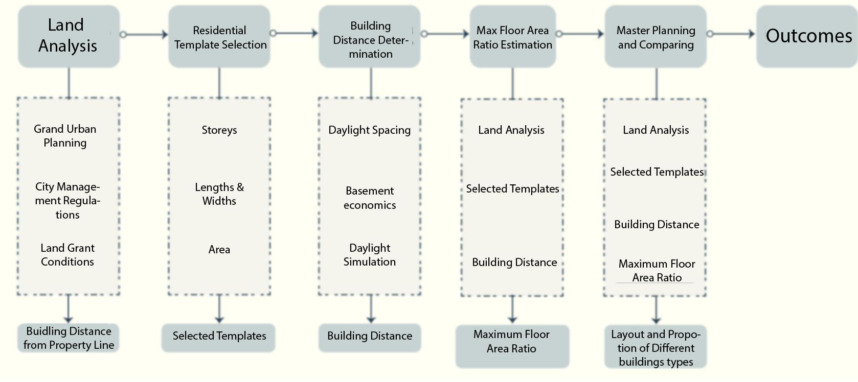
Xinyu concludes the maximum planning of a residential complex into the flowing five steps (Fig. 4): land analysis, residential template selection, building distance determination, maximum floor area ratio estimation, and master planning and comparing 4
4
基于 CGAN 的居住区强排方案生成设计方法 [Research
Generative
Harbin
Fig. 4, five steps of maximum planning (originally in Chinese)
Cong, Xinyu.
on
Design Method of Residential Forced Layout Based on CGAN].
Institute of Technology, 2020
The land analysis mainly studies the surrounding environment, roads, traffic, and supporting facilities. Residential template selection is the decision of the real estate development companies, and large real estate developers usually have their own sets of residential templates from luxurious detached houses to compact high-rise apartments. The number of floors, openings, and the area of the templates are some key factors affecting their decision-making. The distances are determined by codes so that the building layout meets the city’s requirements of minimum daylight distance, fire distance, and sanitary sight distance. The daylight distance is related to the location of the project base, and different cities have different requirements. Maximum floor area ratio calculation and building layout have a mutual influence on each other. Maximum floor area ratio calculation refers to an extreme scenario where the master plan can maximize the use of land resources, i.e. the highest floor area ratio. After the calculation of the extreme, different building combinations (high rises, multi-story buildings, and townhouses) can be obtained by “splitting” floor area ratio, and architects would design multiple viable master plans and then compare them. The chosen master plan in the final is the outcome of maximum planning.
The first three steps are either subject to codes or clients’ decisions. Therefore, current studies on automated planning mostly focus on the last two steps maximum floor area ratio calculation and automated generation of master plans.
Current Studies on the Automation of Residential and Urban Planning
The development of residential planning and design methods has mainly gone through the following periods. Early residential planning used a traditional manual design approach, in which designers followed the process of "preliminary design – building performance simulation – design optimization". This passive adjustment working mode prolongs the design cycle and reduces the efficiency.
In the period of intelligent development of residential planning and design, designers transformed the traditional approach into mathematical logic problems and generated different building forms by changing algorithms 5 Current studies have developed methods for the planning of residential complexes and they mostly focus on optimizing floor area ratio and automatically generating and arranging building groups.
For automated building layouts, the common method is to generate and optimize the arrangement according to the conditions of daylight, fire distance, site boundary, floor area ratio, and layout method. For example, the way of residential buildings layout includes perimeter type, row type, point-slope type, etc. Different layout methods can be generated as the target. Ling Ling wrote the generation algorithm for two types of layout methods, row type, and perimeter type, with sunlight and fire distance as the constraints, and utilized the bricklaying heuristic algorithm 6 .
5 Liang Peijun, and Liu, Yijun. 基于条件生成对抗网络的漫画手绘图上色方法 [Colorization of manga sketch based on conditional generative adversarial networks]. Application Research of Computers, 2019.
6 Ling, Ling, and Wang, Xiaobo. 基于内部可行域的住区建筑物自动布局算法 [Automatic building layout algorithm for settlements based on internal feasible domain]. Computer Technology and Development, 2013.
The residential buildings’ layout can be generated with optimized algorithms such as genetic algorithms and simulated annealing algorithms. Using fire distance, and site area as the constraints, Fei Gao optimized the buildings’ layout with a simulated annealing algorithm to achieve the maximum floor area ratio by changing the location, angle, and number of floors 7 . Mengzhen Han used a genetic algorithm to generate slab-type houses with a row-by-row arrangement with the objective of optimizing sunlight hours 8 .
The multi-intelligence system can also be used to automatically generate building groups' layouts, where each building is viewed as an intelligent body, and constraints such as sunlight and fire distance are used as attributes of the intelligent body, and the intelligent body satisfies the constraints by changing its own behavior. Based on the Netlogo modeling platform, Huijie Liu used sunlight, fire distance, and plot area as constraints to arrange various types of residential buildings 9 .
The integer programming approach in mathematics could do the same work. Hua Hao et al. abstracted the base into a grid form, transformed the residential and shaded areas into
7 Gao, Fei. 基于日照影响的高层住宅自动布局[High-rise Residential Automatic Layout Based on Sunshine Effect]. Nanjing: Nanjing University,2014.
8 Han, Mengzhen. 应用遗传算法生成多层板式住宅组团的行列式布局以优化居住单 元的日照时数 [Application of Genetic Algorithm to Generate Deterministic Layout of Multi-storey Housing Clusters to Optimize the Sunlight Hours of Living Units]. Nanjing: Nanjing University, 2010
9 Liu, Hujie. 多主体模拟的建筑学应用 以 Netlogo 平台为例 [Architecture Application of multi-subject simulation an example of Netlogo platform]. Wuhan: Huazhong Architecture, 2009
templates, and transformed the planning rules into constraints to obtain the scheduling solution with the maximum floor area ratio through the integer programming approach 10 .
Using machine learning and other networks, CNN (convolutional neural networks), GAN, and Monte Carlo Tree algorithms used in XKool Technology enabled the automatic generation of multiple layout schemes based on floor area ratio, building density, and other conditions. The process of human writing the scheduling rules can be eliminated by the machine learning approach 11 .
A wide variety of algorithms are used to solve the residential layout problem by adjusting the location of the residential units under the constraints of site area, fire distance, sunlight spacing, etc., or by changing the number of units, floors, angles, etc. to maximize floor area ratio. In general, the maximization of floor area ratio in residential planning is the common goal in those studies.
Automated Building Groups’ Planning Based on CGAN
In recent years, the development of deep learning (a subset of machine learning, essentially a neural network with three or more layers) has inspired new ideas for planning and
10 Hao, Hua. “Integer Programming for Urban Design.” European Journal of Operational Research 274, no. 3 (2019).
11 Wanyu, He, and Xiaodi, Yang.
[Artificial Intelligence Design, from Research to Practice]. Shanghai: Time + Architecture, 2018.
人工智能设计,从研究到实践
architectural design. Researchers apply deep learning techniques to train machine learning and simulate architects' design process through a large number of cases. The conditional generative adversarial network (CGAN) is one type of deep learning. In CGAN, conditional variables are introduced as additional constraints on the model to guide the whole generation process. CGAN’s method of predicting the maximum planning is image learning in essence. Currently, generative design approaches based on CGAN have been applied in the field of urban planning and architectural design, such as generating urban planning schemes 12,and generating rapidly growing buildings within dense cities 13. Stouffs et al 14 constructed CGAN models to predict the development of urban patterns; Zheng et al 15 constructed CGAN models to generate satellite images, hand-drawn building sketches, and functional zoning of building plans based on boundary and functional training. Isola et al 16 applied CGAN and proposed a generic solution to the image-to-image translation
12 Erik S. Markovian Drift-Iterative substitutional synthesis of 2D and 3D design data using Markov models of source data 36th eCAADe Conference, 2018.
13 Narahara T. Collective construction modeling and machine learning: potential for architectural design 35th eCAADe Conference, 2017.
14 Liu Yuezhong, Stouffs R. 基于条件生成对抗网络的城市设计 研究 [Urban design process with conditional generative adversarial networks]. Architectural Journal, 2018.
15 Zheng Hao. Drawing with bots: human-computer collaborative drawing experiments Learning, Prototyping and Adapting, Short Paper Proceedings of the 23rd International Conference on Computer Aided Architectural Design Research in Asia. Beijing, 2018.
16 Isola P, Zhu Junyan, Zhou Tinghui,et al. Image-to-image translation with conditional adversarial networks IEEE Conference on Computer Vision and Pattern Recognition ( CVPR).Honolulu: IEEE,2017.
problem the Pix2pix model, providing technical support for Tong Zhang’s research method, which is further discussed in this paper.
Pix2pix borrows the idea from CGAN, which inputs not only noise but also a condition when operating. The generator and discriminator of Pix2pix both consist of convolutional neural networks, where convolution can extract features of 2D images, and neural networks can fit complex data distributions. The generator and discriminator are trained to obtain different parameters to fit different data distributions. The generation process is a transformation from image to image. This method is also widely used in generative design because most design works are expressed in visual forms, such as images.
CGAN model has great potential in generative designs for urban road network planning, urban texture generation, neighborhood planning, building hand-drawn sketch generation, building plan functional zoning, and other design tasks. Tong Zhang utilized its strength and developed an automatic method for generating complete layouts of residential complexes. 17
Her research is divided into two parts. The first is the generation of building groups’ arrangement based on boundary conditions. After giving the conditional image and the residential layout plan to neural network for training, the model can automatically generate
17
Tong Zhang. “Experiments On Generation of The Arrangement of Residential Groups Based on Deep Learning,” 2020.
the residential groups' layouts matching to the boundary conditions. Based on the boundary conditions, different experiments were designed to study the generation of different types of residential layouts and the generation of different floor area ratios. The experimental results are then analyzed and verified. The second part is based on the residential spatial organization, the experiment adds more constraints, such as the entrance and main road structure and public space, public green space, making the generation condition as far as possible close to the real residential planning settings. Her 3-phase generation approach allows architects to modify conditions in each step so that the generated results could meet the design requirements.
The 3-phase automatic generation of residential complexes’ planning is her most notable achievement.
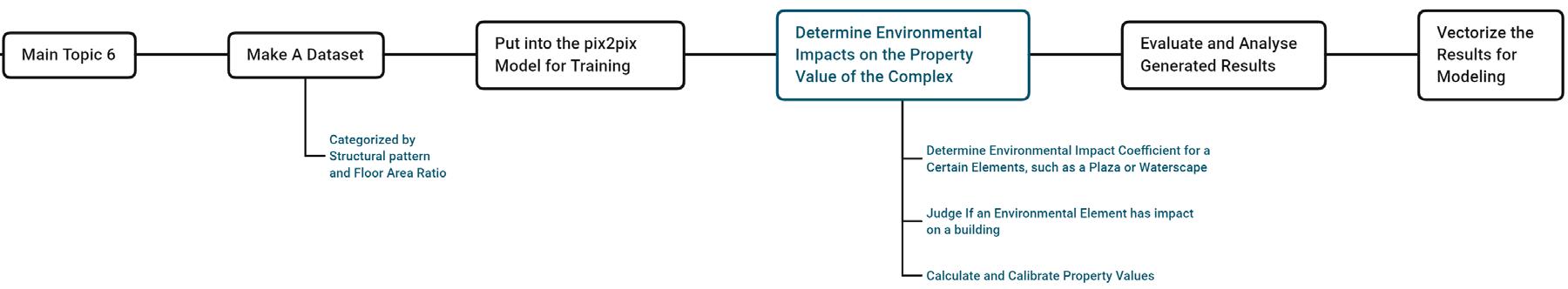
As aforementioned, a typical Chinese residential complex consists of residential areas, landscapes, roads, and public services facilities. Tong designed the experiments in three automated phases, in the order of roads, land zoning, and building groups’ layout (Fig. 4).
The process of each phase is: make a dataset, put into Pix2pix for training and get generated building groups’ layout, evaluate generated results, and finally vectorize the generated layout solutions for modeling needs (Fig. 5).
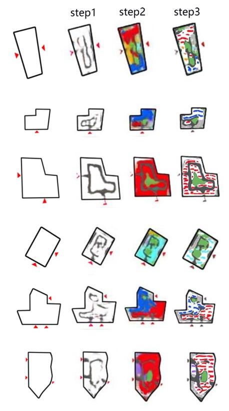 Fig. 5, Tong’s 3-phase automation generation of residential complexes’ planning
Another highlight of her study is a program she wrote. Pix2pix is generated from the imageto-image form while the architectural design is usually based on vector graphics. With OpenCV, she wrote the program for the automatic extraction of image information and bridged the gap between vectors and pixels in her experiments.
While Tong’s CGAN approach is innovative in the automation of residential complexes’ planning, it has limitations and improvement space. Firstly, the CGAN-generated results are occasionally unstable, as the number of training rounds and the amount of data have a great influence on the accuracy and randomness of the results. Secondly, considering only a small amount of data are publicly available, there may be difficulties in data collection and the training of neural networks. Finally, although the automatic generation of a master plan is within seconds, in the preparation stage the training of CGAN models could be time-consuming. It could take several hours to several days to train a model.
An Imaginary Improvement
In
Fig. 6, Tong’s generating and training process
the traditional manual maximum planning process, the assessment of environmental influences (favorable influences such as landscape, plazas, etc.; unfavorable influences
such as surrounding urban arterials, substations, etc.) depends mainly on the subjective judgment of the architect 18 .
Tong's research focuses on the automation of the master planning of residential complexes the last step in the processes of maximum planning. With more steps added to her process of automation, this paper proposes an untested improvement that can estimate the impact of environmental elements on buildings and the whole residential complex’ value, thus increasing the accuracy of automated maximum planning. Below is a modified version based on Tong’s automation process
In Step 1 classification will be added to Tong's dataset preparation. For example, 300 manually designed master plans are collected and sorted according to the seven structural patterns of residential complexes, and the master plans are sorted from the lowest to the
18 Chuanlin,
模型 [Research on Housing Pricing of Real Estate Project in Beicheng Era Based on Hedonic Price Mode]. Chendgu: University of Electronic Science and Technology, 2019.
Fig. 7, Modifications (colored in blue) to Tong’s process
Zhong 北城时代房地产项目住宅定价研究 基于 Hedonic 特征价格
highest by floor area ratio. This classification provides a variety of samples for subsequent analysis and comparison.
Step 2 is similar to Tong's Pix2pix training method. The difference is that the input objects are filtered according to the pre-calculated maximum floor area ratio. This ensures that the generated planning schemes match the desired intensity of land use.
Step 3 is the same as Tong's 3-stage generation strategy. The model trained in Step 2 generates a series of master plans with the essential components of the landscape, residential buildings, and roads.
Step 4 is newly designed to calculate the increased or decreased property values in the residential complex affected by environmental elements. It aims to improve the accuracy of the valuation of the whole maximum planning. Given existing studies lack quantitative research on the impact of environmental elements on property values, this paper proposes the following method, consisting of the assessment of the environmental impact coefficient and the judgment of environmental elements’ effectiveness.
In Xuning Li’s master’s degree dissertation, he proposed a distance-based environmental impact coefficient to estimate the impacts of the urban landscape on housing prices. 19
19
Xuning, Li. 城市景观 对住宅价格的影响
以杭州 市 为例
[Impacts of the Urban Landscape on the Housing Price: A Case Study in Hangzhou] Hangzhou: Zhejiang University, 2013.
While the urban landscape is much larger than the landscape in a residential complex in terms of size and accessibility, the negative correlation between housing price (property value) and their distances is the same. Therefore, inspired by his study, the paper defines the positive environmental coefficient α ( α ≥ 1) and the negative environmental coefficient β (0 < β ≤ 1), such that for a building in a residential complex, its Calibrated Property Value = Preliminary Estimated Value × α ×β
The values of α and β could be collected from the building’s counterparts in other local residential complexes. Taking waterscape, a commonly used technique in residential planning as an example, the researcher could collect and calculate the average property value of 50 local water-view residential buildings of the same type of the studied building, and the ratio of the average property value of waters-view buildings to that of other buildings of the same type in the complex is αwaterscape In the same way, the researchers could estimate the negative coefficient βhighway, βsubstation, βcemetery for negative environmental elements such as highway, substation, cemetery, and other undesirable elements. Whether an environmental element has an impact on the value of a building can be judged by comparing its distance to the building with the smallest daylight distance in the residential complex. The logic is that in ideal maximum planning, the north-south distances between buildings are compressed to the smallest daylight distance. Therefore, if the minimum distance between a building’s outline and the waterscape’s outline is smaller
than the smallest daylight distance in the whole residential complex, the building can be deemed as one of the water-view buildings with a boost in its property value.
The judgement can be carried out in Grasshopper, a platform on Rhino First, input the outlines of a CGAN-generated residential complex from Step 3. Then find the minimum distance between the building’s outline and the landscape’s outline and compare its length with the minimum daylight distance in the residential complex. If greater than the minimum daylight distance, then the building is deemed not affected by the environmental coefficient α, and αn=1; If smaller than the minimum daylight distance, the building is deemed to have a landscape view, and αn = αwaterscape/plaza/greenery/etc Similarly, the effectiveness of the environmental coefficient can be estimated for each building in the residential complex, and the total property value can be calibrated by adding up calibrated values of each building.
Step 5 is the sorting of all calibrated planning schemes from Step 4 from high to low by property value, and the top planning schemes are the results of maximum planning. Step 6 is the same as Tong’s automatic 3D modeling from outlines in Grasshopper.
Still, this imaginary model is in its early conceptual stage, and many factors are neglected. With more time and effort invested, more reasonable and scientific algorithms would be tested and applied to improve the model.
Conclusion
Compared to other methods of residential automatic planning, such as optimized genetic algorithms, annealing algorithms, or multi-intelligence-based residential layout generation, deep learning approaches do not require the writing of specific layout rules, but only the use of data for learning. Deep learning models like CGAN can learn the features of the data and generate new data with these features.
In terms of the generation method, different computer-aided design approaches usually require different rules, while the deep learning approach inputs the initial conditions and corresponding targets to the machine and lets the machine learn the rules by itself, mapping from the conditions to the generated results based on the rules learned from the data.
In terms of the generated results, the deep learning approaches can learn the orientation, spacing, layout, and sparsity of the residential layout, and can identify and generate different residential types. In the generation of planning elements, the generative model can identify the location of entrances and generate road structures. It can learn the location and proportion of each site zoning area and generate new zoning areas with corresponding characteristics.
With the rapid development of big data and artificial intelligence, machine learning related technologies in the field of architecture will become a significant part with plentiful
opportunities. Although the maximum planning consists of many intertwining factors and is of complications. I believe that the cross-disciplinary applications of computers and architecture will be increasingly complete and versatile.
Bibliography
Song, Jinhua, and Hu, Yang. 基于生成式设计的居住区生成强排方案研究 [Research on Maximum Planning of Residential Complexes Based on Generative Design] Wuhan University School of Urban Design, 2018.
Editorial Committee of Architectural Design Sourcebook 建筑设计资料集[Architectural Design Sourcebook]. China Construction Industry Press, 2017.
Cong, Xinyu 基于 CGAN 的居住区强排方案生成设计方法 [Research on Generative Design Method of Residential Forced Layout Based on CGAN]. Harbin Institute of Technology, 2020.
Liang Peijun, and Liu, Yijun. 基于条件生成对抗网络的漫画手绘图上色方法 [Colorization of manga sketch based on conditional generative adversarial networks] Application Research of Computers, 2019.
Ling, Ling, and Wang, Xiaobo. 基于内部可行域的住区建筑物自动布局算法 [Automatic building layout algorithm for settlements based on internal feasible domain]. Computer Technology and Development, 2013.
Gao, Fei. 基于日照影响的高层住宅自动布局[High-rise Residential Automatic Layout Based on Sunshine Effect]. Nanjing: Nanjing University,2014.
Han, Mengzhen. 应用遗传算法生成多层板式住宅组团的行列式布局以优化居住单元 的日照时数 [Application of Genetic Algorithm to Generate Deterministic Layout of Multi-storey Housing Clusters to Optimize the Sunlight Hours of Living Units] Nanjing: Nanjing University, 2010.
Liu, Hujie. 多主体模拟的建筑学应用 以 Netlogo 平台为例 [Architecture Application of multi-subject simulation an example of Netlogo platform]. Wuhan: Huazhong Architecture, 2009
Hao, Hua. “Integer Programming for Urban Design.” European Journal of Operational Research 274, no. 3 (2019).
Wanyu, He, and Xiaodi, Yang. 人工智能设计 , 从研究到实践 [Artificial Intelligence Design, from Research to Practice]. Shanghai: Time + Architecture, 2018.
Erik S. Markovian Drift-Iterative substitutional synthesis of 2D and 3D design data using Markov models of source data 36th eCAADe Conference, 2018.
Narahara T. Collective construction modeling and machine learning: potential for architectural design 35th eCAADe Conference, 2017.
Liu Yuezhong, Stouffs R. 基于条件生成对抗网络的城市设计 研究 [Urban design process with conditional generative adversarial networks]. Architectural Journal, 2018.
Zheng Hao. Drawing with bots: human-computer collaborative drawing experiments Learning, Prototyping and Adapting, Short Paper Proceedings of the 23rd International Conference on Computer Aided Architectural Design Research in Asia. Beijing, 2018.
Isola P, Zhu Junyan, Zhou Tinghui,et al. Image-to-image translation with conditional adversarial networks IEEE Conference on Computer Vision and Pattern Recognition ( CVPR).Honolulu: IEEE,2017.
Tong Zhang. “Experiments On Generation of The Arrangement of Residential Groups Based on Deep Learning,” 2020.
Chuanlin, Zhong 北城时代房地产项目住宅定价研究 基于 Hedonic 特征价格模
型 [Research on Housing Pricing of Real Estate Project in Beicheng Era Based on Hedonic Price Mode]. Chendgu: University of Electronic Science and Technology, 2019.
Xuning, Li 城市景观对住宅价格的影响 以杭州市为例 [Impacts of the Urban Landscape on the Housing Price: A Case Study in Hangzhou] Hangzhou: Zhejiang University, 2013
List of Figures
Fig. 1 Wang, Hongdu. The Composition of a Typical Chinese Residential Complex. n.d. Made by the author.
Fig. 2 Birds-Eye View of a Residential Complex. Accessed April 23, 2022. http://www.jiajujiazhuang.com/xiaoguotu/3921.html.
Fig. 3 Editorial Committee of Architectural Design Sourcebook 建筑设计 资料集 Architectural Design Sourcebook]. China Construction Industry Press, 2017.
Fig. 4 Cong, Xinyu 基于 CGAN 的居住区强排方案生成设计方法 [Research on Generative Design Method of Residential Forced Layout Based on CGAN]. Harbin Institute of Technology, 2020. Translated by the author.
Fig. 5-6 Tong Zhang. “Experiments On Generation of The Arrangement of Residential Groups Based on Deep Learning,” 2020.
Fig. 7 Wang, Hongdu. Modifications to Tong’s process. Made by the author.
