

Town of


Date February 2025
Title Town of Riverdale Park Community Forest Management Plan
Author The Maryland-National Capital Park and Planning Commission
Subject Municipal Street Tree Inventory, Management and Care
Source of copies The Maryland-National Capital Park and Planning Commission 1616 McCormick Drive
Upper Marlboro, MD 20774
Series number 235252306
Number of pages 97
This document is a Community Forest Management Plan for the Town of Riverdale Park, a municipality in Prince George’s County, Maryland, incorporated in 1920 (Planning Area 68, Councilmanic District 3). In December 2021, the Town applied to the Prince George’s County Planning Department via the Department’s Planning Assistance to Municipalities and Communities Program (PAMC) to fund a tree inventory and management plan. Funding for the project was approved by the Prince George’s County Planning Board on May 26, 2022, the kickoff was held in January 2023 and the project was completed in February 2025.
The purpose of the project was to assess the condition of trees in public rights-of-way within the municipal boundary and provide Town staff with the tools and data to make informed decisions on protecting, maintaining, and expanding the Town’s street tree inventory.
Tree inventory data were collected pursuant to the Maryland Roadway Tree Law by Maryland Licensed Tree Experts (LTE) or equal (International Society of Arboriculture Certified Arborists). Data were entered into the Prince George’s County Department of Public Works and Transportation’s (DPW&T) PlanIt Geo TreePlotter™ software to generate graphic and spatial representations of existing conditions that revealed needs and opportunities. The findings of the tree inventory and condition assessment directly informed this plan that includes a prioritized management program for future tree care.
Artie Harris, Jr., Chair
Peter A. Shapiro, Vice Chair
Officers
William Spencer, Acting Executive Director Gavin Cohen, Secretary-Treasurer
Debra Borden, General Counsel
The Maryland-National Capital Park and Planning Commission (M-NCPPC) is a bicounty agency, created by the General Assembly of Maryland in 1927. The Commission’s geographic authority extends to the great majority of Montgomery and Prince George’s Counties: the Maryland-Washington Regional District (M-NCPPC planning jurisdiction) comprises 1,001 square miles, while the Metropolitan District (parks) comprises 919 square miles, in the two counties.
The Commission has three major functions:
• The preparation, adoption, and, from time to time, amendment or extension of the General Plan for the physical development of the Maryland-Washington Regional District.
• The acquisition, development, operation, and maintenance of a public park system.
• In Prince George’s County only, the operation of the entire county public recreation program.
The Commission operates in each county through a Planning Board appointed by and responsible to the County government. All local plans, recommendations on zoning amendments, administration of subdivision regulations, and general administration of parks are responsibilities of the Planning Boards.
The Prince George’s County Planning Department:
• The mission of the Prince George’s County Planning Department is to promote economic vitality, environmental sustainability, design excellence, and quality development that promotes healthy lifestyles in Prince George’s County neighborhoods.
• Our vision is to be a model planning department of responsive and respected staff who provide superior planning and technical services and work cooperatively with decision makers, citizens, and other agencies to continuously improve development quality and the environment and act as a catalyst for positive change.


Tara H. Jackson, Acting County Executive
County Council
The County Council has three main responsibilities in the planning process: (1) setting policy, (2) plan approval, and (3) plan implementation. Applicable policies are incorporated into area plans, functional plans, and the general plan. The Council, after holding a hearing on the plan adopted by the Planning Board, may approve the plan as adopted, approve the plan with amendments based on the public record, or disapprove the plan and return it to the Planning Board for revision. Implementation is primarily through adoption of the annual Capital Improvement Program, the annual Budget, the water and sewer plan, and adoption of zoning map amendments.
Council Members
Jolene Ivey, Chair, At-large
Edward P. Burroughs, III, Vice Chair, 8th District
Thomas E. Dernoga, 1st District
Wanika B. Fisher, 2nd District
Eric C. Olson, 3rd District
Ingrid S. Watson, 4th District
Vacant, 5th District
Wala Blegay, 6th District
Krystal Oriadha, 7th District
Sydney J. Harrison, 9th District
Calvin S. Hawkins, II, At-large
Clerk of the Council: Donna J. Brown
Charts
Chart 1. Distribution of the Top Five Species in the Inventory 17
Chart 2. Distribution of the Top Five Genera in the Inventory 17
Chart 3. Distribution of the Top Five Families in the Inventory �������������������� 17
Chart 4. Condition of Inventoried Trees 23
Chart 5. Relative Age Distribution of Inventoried Trees ���������������������������������� 24
Chart 6. Condition of Inventoried Trees by Relative Age (size class) 25
Chart 7. Estimated Value of Annual Benefits of Inventoried Trees 3 2
Tables
Table 1. Recommended Species List for Added Diversity 19
Table 2. Tree Conflicts with Overhead Infrastructure 27
Table 3. High-Priority Pruning or Removals of Inventoried Trees ������������� 36
Table 4. Secondary Maintenance Recommendations 36
Table 5. Observed Planting Spaces 36
Table 6. Locations of High-Priority Prunings and Removals 39
Table 7. Observed Plantable Spaces in Riverdale Park 46
Figures
Figure 1. Improperly pruned tree
Figure 2. Mechanical damage at base of young tree 21
Figure 3. Adaptive Management Cycle
Map 2A. Plantable Spaces in Northwest Quadrant
Map 2B. Plantable Spaces in Southwest Quadrant
Map 2C. Plantable Spaces in Northeast and Southeast Quadrants ����

An effective public tree management approach must consider the condition of the inventoried tree population for a robust tree management plan
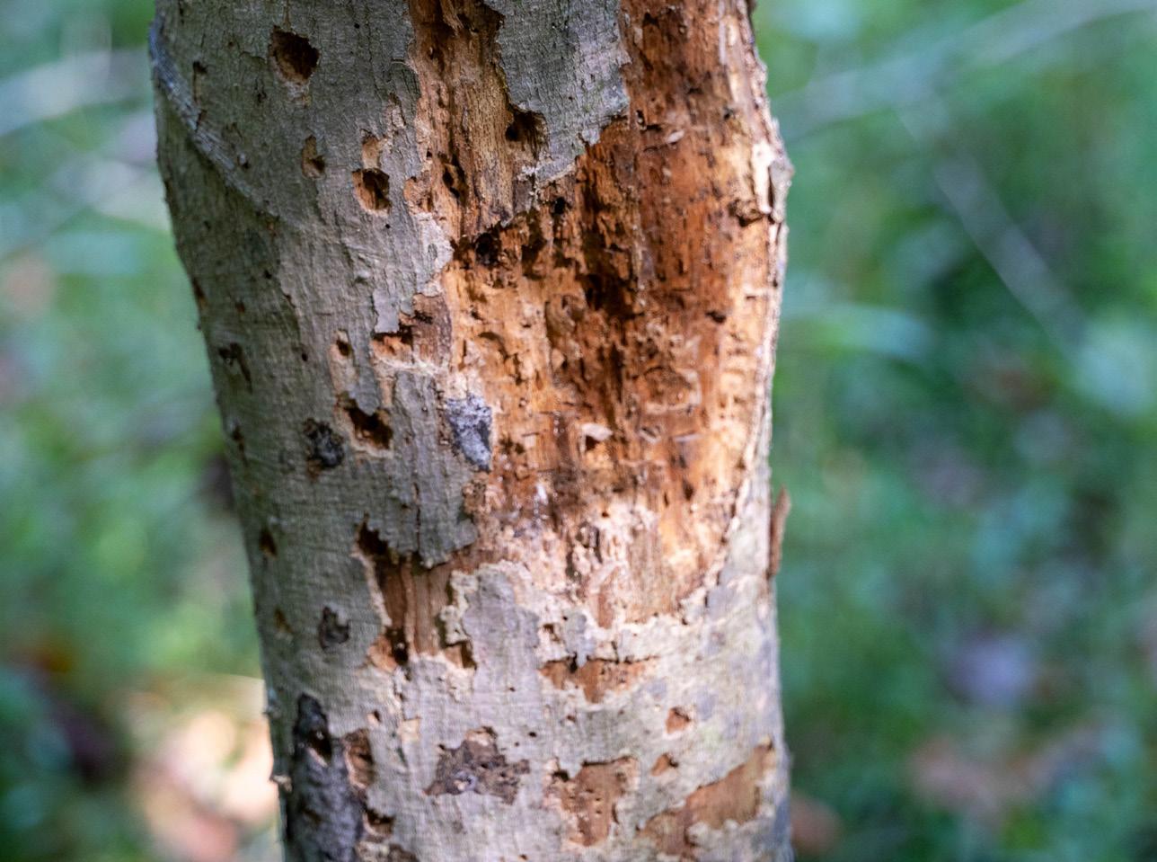


A diversity of tree species, genera, and tree family can mitigate the effects of disturbances by pests, extreme weather, and climate change
Trees are assessed for their overall condition and maintenance needs during a street tree inventory
�


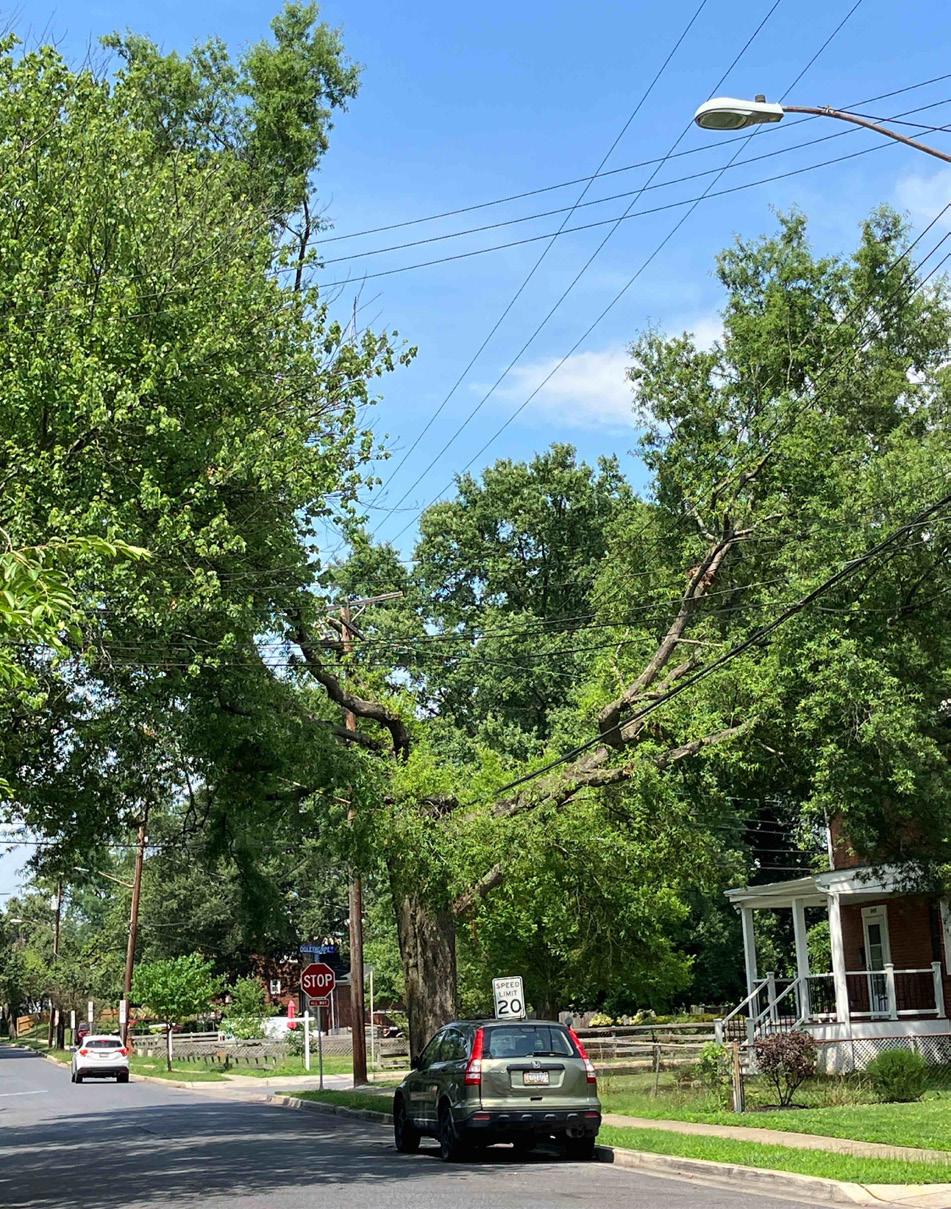
Calculating the size at maturity of future plantings located near power distribution lines can reduce conflicts with overhead utilities
PHOTO: M-NCPPC
Urban environments have unique challenges that make the annual functional benefits (such as shading, cooling, and beauty) provided by Riverdale Park’s inventoried trees an essential asset to the Town

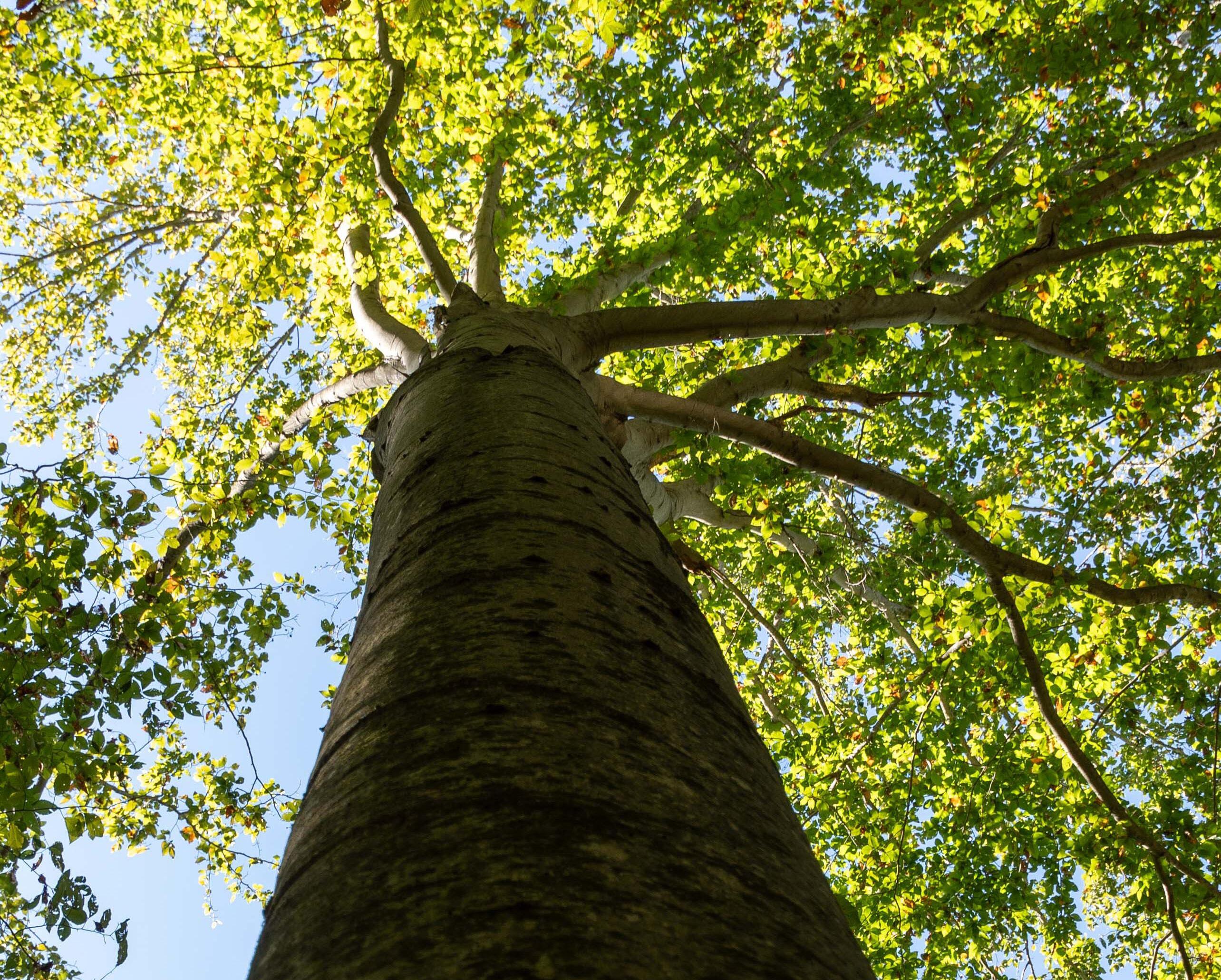
An analysis of tree size offers insight into the age and maintenance needs of this tree in Prince George’s County

Among the economic benefits of a robust public tree resource, commercial property rental rates rise in areas with tree populations
PHOTO: M-NCPPC
The Town of Riverdale Park is home to over 7,000 residents (U.S. Census Bureau 2020 estimate) benefitting from public trees in their community. The Town’s public works department manages all trees, stumps, and planting sites along the street rights-of-way (ROW) and throughout public parks. The Town is an active partner with the Maryland Urban and Community Forest Committee and the Maryland Department of Natural Resources Forest Service, participating in its People Loving and Nurturing Trees (P.L.A.N.T.) Community Awards Program. In addition, the Town partners with Pepco’s Energy-Saving Trees Program for residential lot tree plantings.
In December 2021, the Town of Riverdale Park applied to the Prince George’s County Planning Department via the Department’s Planning Assistance to Municipalities and Communities Program (PAMC) to fund a tree inventory and management plan. The Town had conducted an inventory in 2019 but it rapidly became obsolete and a new, actively managed, and more comprehensive approach was needed.
The PAMC program is offered by The MarylandNational Capital Park and Planning Commission (M-NCPPC), Prince George’s County Planning Department, Community Planning Division, Neighborhood Revitalization Section. The program’s purpose is to assist in protecting and implementing the County’s approved plans, recommendations made in Planning Department studies, and strategies and action items in approved Maryland Sustainable Communities action plans. The program provides technical planning services at no cost to municipalities or community organizations using Prince George’s County Planning Department expertise, and/or funds consultant services approved by the Planning Board. PAMC projects benefit municipalities and communities that may have limited planning resources but are committed to revitalization and enhancement of their communities.
The Town sought guidance to maintain, expand, and protect the Town’s municipal tree population and canopy; create fully tree-lined streets through annual tree planting; make data-driven funding
and tree maintenance decisions; and educate and engage residents.
Funding for the project was approved by the Prince George’s County Planning Board on May 26, 2022, and the firm Kimley-Horn was retained to undertake the study. Their consultant team included Wetland Studies and Solutions, Inc. The project consisted of an assessment of trees in public rights-ofway within the municipal boundary of Riverdale Park. Data collected were entered into the Prince George’s County Department of Public Works and Transportation’s PlanIt Geo TreePlotter™ software to generate graphic and spatial representations of existing conditions to reveal needs and opportunities. The findings of the tree inventory and condition assessment directly informed the tree management plan. In total, 2,371 trees and 325 plantable spaces were inventoried. The kickoff was held in January 2023 and the project was completed in February 2025.
This Community Forest Management Plan builds on polices and strategies in Plan 2035 and active community plans: the 1994 Approved Master Plan
for Planning Area 68 and the 2004 Approved Town of Riverdale Park Mixed-Use Town Center Zone Development Plan
Plan 2035 states, “Plan 2035 recommends sustaining the County’s combined forest and tree canopy coverage at 52 percent,” (p. 169). Forests and Tree Canopy Policy 5 (p. 176) is to, “Preserve and enhance existing forest and tree canopy coverage levels.” Strategy NE5.1 (p. 176) is to “Prepare a comprehensive forest and tree canopy coverage strategy that supports Plan 2035’s vision, goals, and development pattern.” Strategy HD9.7 is to “Identify and prioritize areas for street tree installation.” Strategy HD11.2 states, “Promote the use of the Planning Assistance to Municipalities and Communities Program as a tool to complete smallscale urban design analyses to address urban design challenges and opportunities,” (p. 216). The 2004 Approved Town of Riverdale Park Mixed-Use Town Center Zone Development Plan: Development and Design Concepts (p. 27) include, “Soften the streetscape and increase attractiveness through flowers, shade trees, and street furniture.”
The Vision for the 1994 Approved Master Plan for Planning Area 68 includes, “We are proud of the stately trees that line many of our streets and shade our parks. We envision a future where more trees have been planted in parks, along streets and on private property. In the future, as today, we regard woodlands, parks and open spaces as a welcome respite from crowds, cars and concrete. We will take the responsibility as a community to protect and enjoy them,” (p. 2).
Objective VI, p. 26, is to “Create a community-based program to expand the area’s urban forest. The urban forest generally consists of street trees, landscape trees and native trees which do not form the multilayer canopy of trees, shrubs and herbaceous growth of undisturbed woodlands. However, this type of tree cover is particularly important because it constitutes a significant amount of the community’s tree cover. County staff should be assigned to work with the community to establish effective programs. These programs should include the following elements:
• A detailed inventory of street trees, champion trees and yard trees. This information can then be used to establish maintenance programs for those trees in poor health or needing removal;
• Street tree planting guidelines and a street tree planting program. A street tree maintenance program should be established within each community to plant additional trees and improve the maintenance of existing plantings;
• An educational network which will provide information to homeowners on the value of trees in an urban area, proper maintenance techniques and where to obtain assistance and information on trees;
• And a funding assistance network which will identify governmental funding sources that may be utilized and funding from local businesses and community outreach programs.”
An effective approach to tree resource management follows a proactive and systematic program that sets clear and realistic goals, prescribes future action, and periodically measures progress. A robust urban forestry program establishes tree maintenance priorities and utilizes asset management software.
Consisting of three sections, this plan considers the diversity, distribution, and condition of the inventoried tree population and provides a prioritized system for managing Riverdale Park’s public tree resource (i.e., the publicly managed trees providing environmental benefits to the Town).
Species, Genus, and Family Distribution summarizes the inventory data with trends representing the current state of the tree resource.
Functions and Benefits of the Public Tree Resource summarizes the estimated value of benefits provided to the community by public trees’ various functions.
Recommended Management of the Public Tree Resource details a prioritized management program and maintenance activities.
The 10-20-30 rule is a common standard for tree population distribution in which a single species should comprise no more than 10 percent of the tree population, a single genus no more than 20 percent, and a single family no more than 30 percent (Santamour 1990). This standard was developed partially in response to devastations such as that of the American elm (Ulmus americana) after the accidental introduction of Dutch elm disease circa 1928. Practicing the 10-20-30 rule helps protect urban forests from pests, diseases, extreme weather events, and climate change.
Chart 1 shows Riverdale Park’s distribution of the most abundant tree species inventoried along street rights-of-way compared to the 10 percent threshold. Willow oak (Quercus phellos) is the most abundant species within the inventoried area, comprising 11 percent of the inventoried street trees and exceeding the 10 percent recommend threshold for a single species. Callery pear (Pyrus calleryana), and the commonly known cultivar Bradford pear is the second most abundant street tree, comprising 10 percent of the inventoried tree population. Leyland cypress (Cupressus x leylandii) and Red maple (Acer rubra) are close contenders for third most abundant species, comprising 8 percent of inventoried trees.
Chart 2 shows the Town’s distribution of the most abundant tree genus (or type) inventoried in the rights-of-way. Oak (Quercus) is the highest represented genera with 17 percent of the inventoried public trees. Maple (Acer) follows with 14 percent of the inventoried public trees. Both genera are below the recommended 20 percent threshold for genus representation, demonstrating appropriate levels of diversification at their current state.
Chart 3 shows the Town’s distribution of the most abundant tree families inventoried compared to the 30 percent threshold. Species in the Fagaceae family, which includes Oak trees, represent 27 percent of the street trees. All the other families were well below the recommended threshold.
10% 20% 30%
Chart 1. Distribution of the Top Five Species in the Inventoried Tree Population SPECIES
Chart 2. Distribution of the Top Five Genera in the Inventoried Tree Population GENERA
Chart 3. Distribution of the Top Five Families in the Inventoried Tree Population FAMILIES
The species, genus, and family distribution of an urban tree population can be a useful metric for gauging the ability of the urban forest to resist disruption by pests, diseases, extreme weather, and climate change, as well as the forest’s resilience, or ability to recover from these disruptions (Ordoñez & Duinker 2014).
For example, certain pests, like emerald ash borer (Agrilus planipennis), target a single genus (ash, Fraxinus spp.) as their host, and different species of tree have varying susceptibility to extreme weather events (Hauer et al. 2006, Duryea & Kampf 2007), which will become more common as the climate changes.
Some pests also target a single family as their host, such as the bacterium Erwinia amylovora, commonly known
as fireblight. Fireblight affects only plants in the rose family (Rosaceae), such as serviceberry (Amelanchier spp.), hawthorn (Crataegus spp.), apple/crabapple (Malus spp.), cherry/plum (Prunus spp.), and pear (Pyrus spp.).
An urban forest with low species, genera, or family diversity is more likely to be damaged by pests, disease, weather, and climate disruptions due to the presence of large populations of susceptible trees. It is also likely to be less resilient, or less capable of recovering from such disturbances, since large portions of the urban forest may be eliminated or damaged by these disturbances.
Cultivating diversity on the species, genus, and family levels can help mitigate the effects of disturbances and ensure a thriving urban forest now and in the future.
The street trees in Riverdale Park could benefit from increased diversity at the species level where, as shown in Chart 1, Willow oak represent 11 percent and Callery pears represent 10 percent of inventoried species. Leyland cypress and Red maple each are eight percent of the inventoried street trees. It should be noted that there are likely many more individuals of these species in the parks, corporate and government facilities, and private residential lots that were not inventoried. Therefore, the total Town tree diversity may be lower, thus exposing the tree canopy to more disturbance.
Diversity among the right-of-way tree population can be increased over time by limiting or avoiding the planting of oak and increasing the overall diversity of new plantings.
Town trees, particularly those susceptible to spotted lanternfly, Asian longhorned beetle, and spongy moth, should also be routinely monitored for signs and symptoms of pests or diseases. Early detection will allow for expedient management, reducing the overall costs of managing the outbreak while minimizing damage to the urban forest.
Size at Maturity Recommended Species
Table 1. Recommended Species List for Added Diversity
Small, potential utility plantings
Large
Washington Hawthorne (Crataegus phaenopyrum)
Hedge Maple (Acer campestre)
Trident Maple (Acer buergeranum)
Sweetbay Magnolia (Magnolia virginiana)
Yoshino Cherry (Prunus x yedoensis)
Crape Myrtle (Lagerstroemia indica)
Red Buckeye
Ginkgo (male) (Ginkgo biloba)
Honeylocust (spineless) (Gleditsia triacanthos var. inermis)
Southern Manolia (Magnolia grandiflora)
London Planetree (Platanus x acerifolia)
Zelkova (Zelkova serrata)
American Linden (Tilia americana)
American Sycamore (Platanus occidentalis)
American Hopcornbeam (Ostrya virginiana)
Common Hackberry (Celtis occidentalis)
American Hornbeam (Carpinus caroliniana)
*Table does not include recommendations for Quercus species.
For each tree inventoried, the most significant defect was recorded. Defect observations were limited to the following categories:
Canker
Cavity decay
Crown dieback
Frost cracks
Girdling roots
Grate/guard
Hardscape damage
Improperly installed
Improperly mulched
Improperly pruned
Mechanical damage
Nutrient deficiency
Pests
Poor location
Poor root system
Poor structure
Remove hardware
Serious decline
The most common defect among inventoried street trees was improper mulching (nine percent of inventoried street trees have this defect). Crown dieback, cavity decay, and poor structure were tied for the second most common defect among street trees (six percent). The third most common defect among street trees was girdling roots (five percent).
When considering recorded defects, two qualifiers should be kept in mind. First, the categories are broadly inclusive. For example, the “cavity decay” category can include both small diameter cavities high on the tree trunk that are currently not structurally critical, as well as large diameter cavities at the base of the trunk or at large trunk unions that pose a serious structural risk. Therefore, inferences on overall tree condition or risk rating cannot be derived solely from the presence or absence of a defect recorded during the inventory. Second, an inventoried tree may have
multiple defects, the presence of which may also not lead to accurate overall tree condition or risk rating from multiple defects.
The fact that improper mulching was the most recorded defect during the 2023 inventory indicates that many significant tree defects could be remedied by correcting mulch rings.
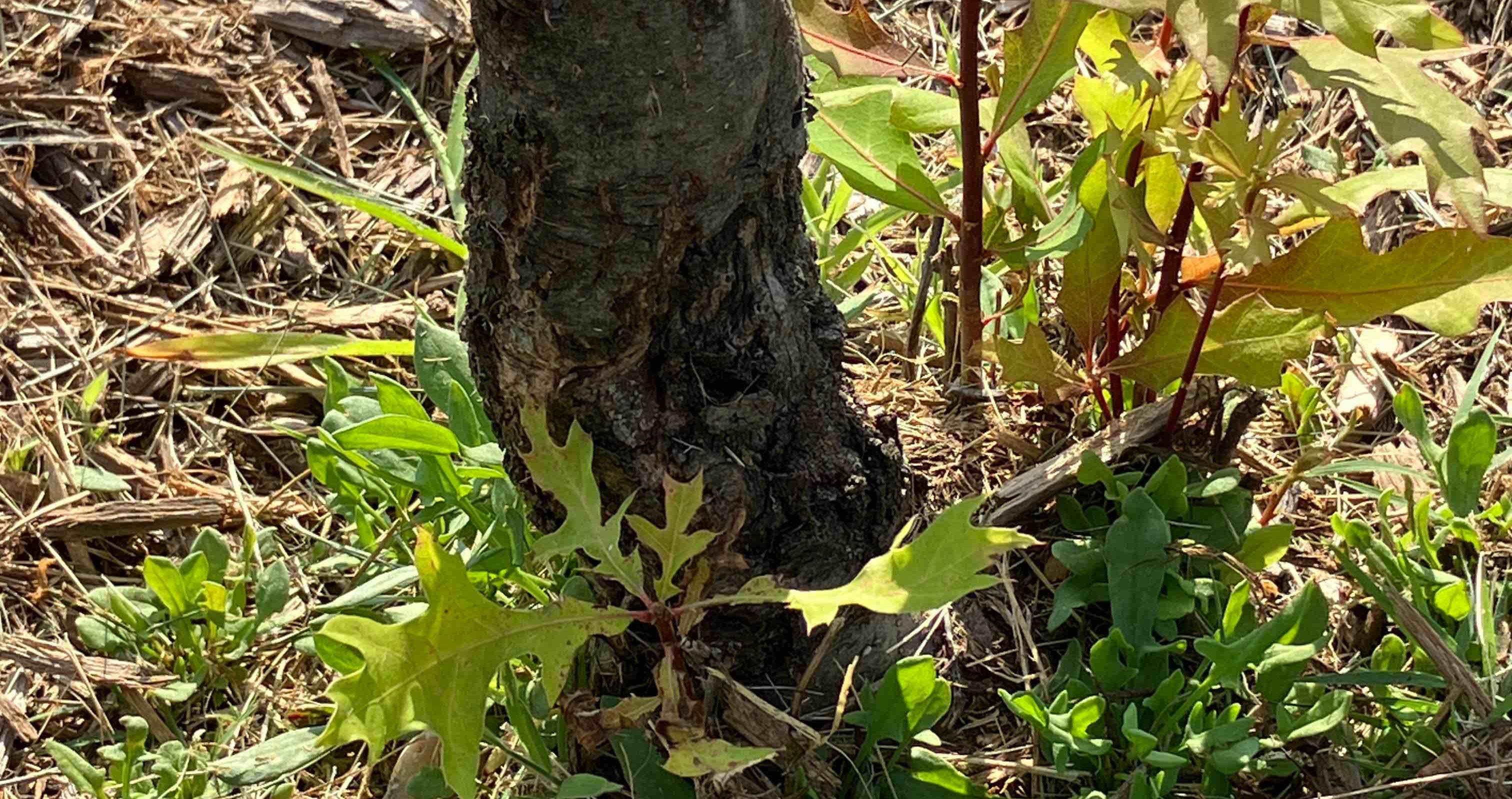
Trees with a defect and recommended for priority pruning or removal should be addressed as soon as practical to eliminate risks from defective parts or pest/disease spreads. Trees recorded with a defect and recommended for advanced inspection should be assessed by qualified personnel equipped with suitable tools to determine the next steps needed to mitigate risk or salvage the tree.
Trees recorded with a defect but not recommended for further monitoring, priority pruning, or removal should be inspected as part of a routine assessment program designed to identify potentially hazardous trees and emerging disease or pest outbreaks. Routine assessments by qualified arborists or other qualified personnel can aid in identifying potentially hazardous tree defects before they become significant dangers to people or property.
Factors affecting overall tree condition were considered for each tree in the inventory, including root characteristics, branch structure, trunk, canopy, foliage condition, and the presence of pests or diseases. These were identified within the Tree Plotter™ inventory software. The condition of each inventoried tree was rated as healthy, fair, poor, critical or dead
The general health of the inventoried tree population was characterized by the most prevalent condition assigned during the inventory.
Chart 4 shows that most of the inventoried trees along the streets were recorded in healthy or fair condition. Based on these data, the general health of the inventoried tree population is rated as healthy
Dead trees and many trees in poor condition should be removed as soon as possible because the health of these trees is unlikely to recover even with increased care, and these trees may present a risk to people or property.
Younger trees rated in fair or poor condition may benefit from proper mulching and structural pruning to improve their health over time. Pruning should follow ANSI A300 (Part1) guidelines. Poor condition ratings among mature trees (>24” DBH) were
generally due to crown dieback, cavity decay, or poor structure. These trees will likely require corrective pruning and intensive plant health care to improve their vigor and should be monitored for worsening conditions.
Trees in fair condition may benefit from correcting mulch to expose root flares and crown cleaning or structural pruning to remove dead or defective limbs and may return to a healthy condition with time and care.
Analysis of a tree population’s relative age distribution is performed by assigning age classes to the size classes of inventoried trees. Size is used as a proxy for age because of the difficulty of accurately and easily measuring the age of living trees.
Since tree species have different lifespans and mature at different diameters, actual tree age cannot be determined from diameter size class alone, but size classifications can be extrapolated into relative age classes which can offer insight into the maintenance needs of Riverdale Park’s tree resource. The inventoried trees were grouped into the following relative age classes:
• Young trees (0–8 inches diameter at breast height or DBH)
• Established trees (9–17 inches DBH)
• Maturing trees (18–24 inches DBH)
• Mature trees (greater than 24 inches DBH)
Chart 5. Relative Age Distribution of Inventoried Trees
These size classes were chosen so that the inventoried tree resource could be compared to the ideal relative age distribution, which holds that the largest proportion of the inventoried tree population (approximately 40 percent) should be young trees, while the smallest proportion (approximately 10 percent) should be mature trees (Richards 1983).
Chart 5 shows the relative age distribution of the inventoried street tree population compared to the ideal distribution proposed by Richards. The street tree population generally follows the ideal age distribution, with only a slight overabundance of young (47 percent versus 40 percent as the ideal) and established trees (32 percent versus 30 percent ideal), a slight shortage of maturing trees (12 percent versus 20 percent ideal), and an ideal mature tree population (10 percent = 10 percent ideal).
Among the inventoried street trees, a healthy condition rating was the most common for all age classes. Healthy condition ratings increased with relative age class, with 47 percent of established trees, 49 percent of maturing trees, and 54 percent of mature trees rated as being in healthy condition.
Fair and poor or worse condition ratings increased with relative age class (28 percent and 10 percent for young street trees, respectively; 44 percent and 9 percent for established trees, respectively; 42 percent and 9 percent for maturing trees, respectively; and 39 percent and 7 percent for mature trees, respectively). This is not an uncommon trend to find among tree populations—older and larger trees have had more time to accrue defects.
Riverdale Park has a slight surplus (47 percent versus an ideal 40 percent) of young street trees, likely a result of the Town’s partnership with local and regional entities’ tree-planting programs. While this surplus in
Cross-analysis of the condition of the inventoried tree resource with its relative age distribution provides insight into the inventoried population’s stability over time.
Chart 6. Condition of Inventoried Trees by Relative Age (size class)
young trees is a positive step for the future of the Town’s urban forest, it is important to note that young trees are easily damaged and require maintenance (especially watering) during the first years after planting. The current surplus is a bulwark against potential planting failure; however, the overall fair or better condition ratings for all tree populations and age classes indicate that the young trees have a good chance of reaching maturity if they are well-maintained.
Ideally, annual tree plantings should, at a minimum, compensate for annual tree removals. Planting additional new trees beyond this benchmark should help shift the age distribution of Riverdale Park’s trees toward the ideal 40-30-20-10 percent age distribution over time.
In addition, the Town should implement a robust and proactive maintenance program to conserve the condition of young and established trees as they age and to protect mature and maturing trees from succumbing to treatable defects.
Trees in restricted growing spaces such as an urban setting may conflict with buildings, sidewalks, utility wires, and pipes. Such conflicts can pose risks to public safety and require significant investments of time and money to mitigate. Existing or potential conflicts between trees and infrastructure observed and recorded during the 2023 inventory include overhead utilities
The presence of overhead utility lines above a site was noted in several instances. All overhead utilities—including primary and secondary electricity distribution lines, telecommunications lines, and drop lines to residences and businesses—were considered when determining if overhead utilities existed within the air space currently or potentially occupied by a tree crown. A tree was considered to have overhead utilities present if an overhead line ran within 10 feet (the minimum approach distance) of the tree crown.
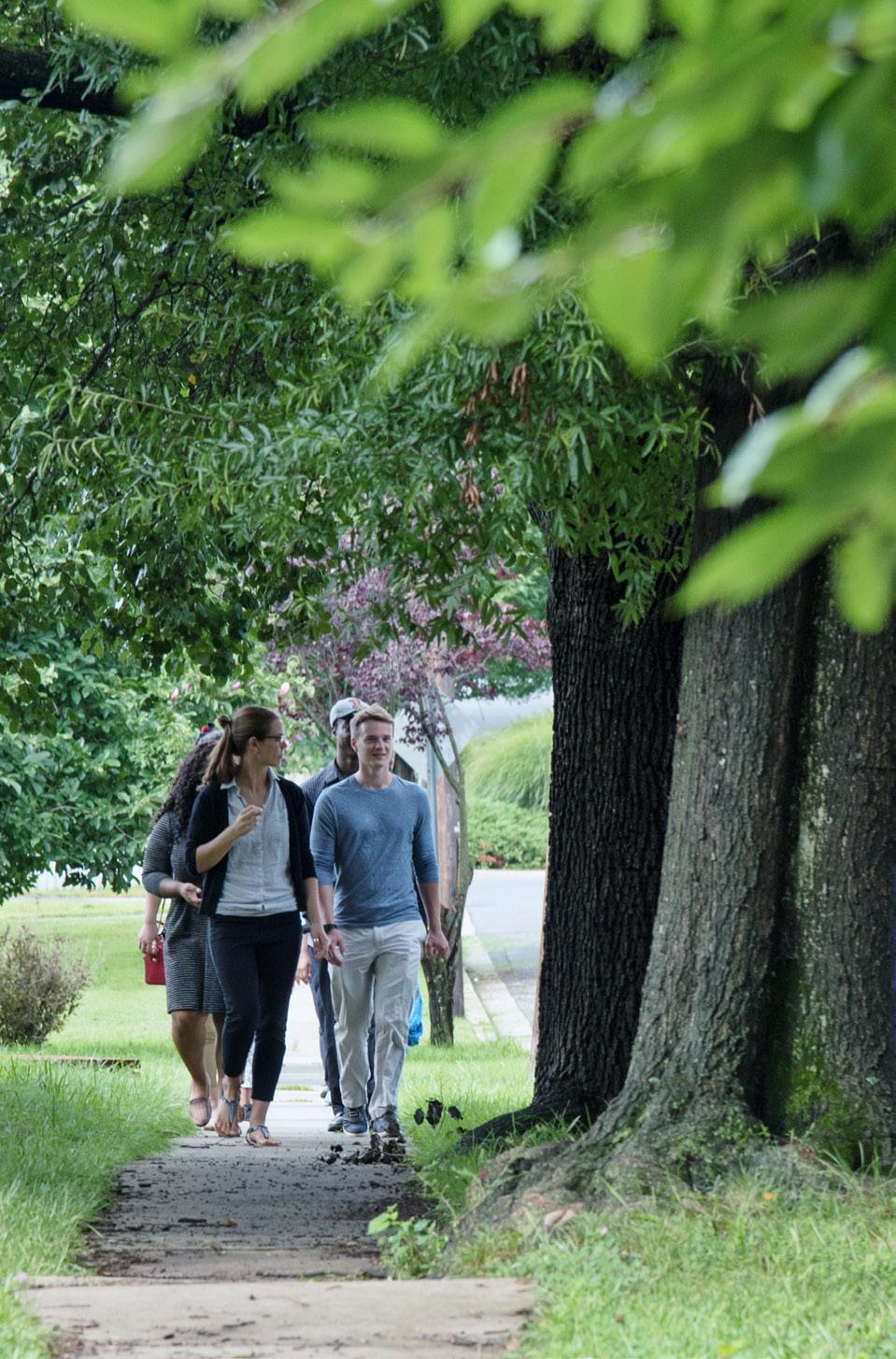
These right-of-way trees offer sufficient canopy but compete with the surrounding hardscape environment in Riverdale Park
To reduce conflicts with overhead utilities, Riverdale Park should consider the mature size of any future plantings located under or near overhead lines. The Town should plant only small-stature trees within 20–40 feet of the path followed by overhead lines, and large-stature trees outside 40 feet.
All plantings should be located at least 15 feet away from utility poles. However, since nearly 37 percent of Riverdale Park’s street trees are currently located near
utility lines, planting plans may need to be expanded beyond the Town-maintained ROW if canopy coverage is to be maintained or increased over time. This can include additional planting in parks, near schools, and on municipal property.
The Town may also consider working with private landowners and encouraging residential tree planting to locate medium and large stature trees beyond the ROW and away from overhead utility lines.
Table 2 shows the number and percentage of inventoried trees which had overhead utilities present within 10 feet of the tree’s crown. Of the street trees (and identified plantable space), 251 trees (10.6 percent) were within the minimum approach distance of an overhead utility.
Trees occupy a vital role in the urban environment by providing an array of economic, environmental, and social benefits far exceeding investments in planting, maintaining, and removing them. Trees reduce air pollution, improve public health outcomes, reduce stormwater runoff, sequester and store carbon, reduce energy use, and increase property values. i-Tree Eco and other models in the i-Tree software suite provide tools to estimate the monetary value of the various benefits provided by a public tree resource.
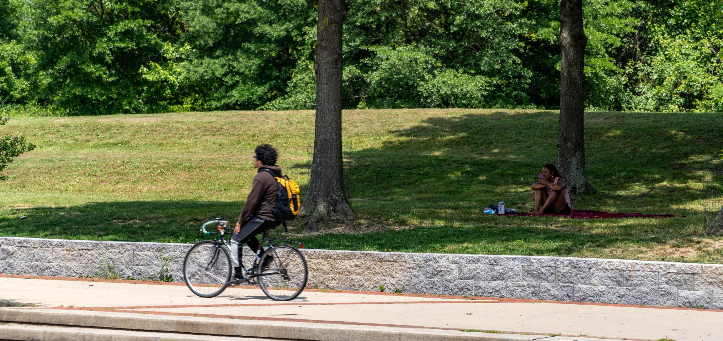
Trees in Prince George’s County offer such advantages as cooling and airborne pollutant removal
• Trees decrease energy consumption and moderate local climates by providing shade and acting as windbreaks.
• Trees act as mini reservoirs, helping to slow and reduce the amount of stormwater runoff that reaches storm drains, rivers, and lakes. One hundred mature tree crowns intercept roughly 100,000 gallons of rainfall per year (U.S. Forest Service 2003a).
• Trees help reduce noise levels, cleanse atmospheric pollutants, produce oxygen, and absorb carbon dioxide.
• Trees can reduce street-level air pollution by up to 60 percent (Coder 1996). Lovasi (2008) suggested that children who live on tree-lined streets have lower rates of asthma.
• Trees stabilize soil and provide a habitat for wildlife.
• Trees in a yard or neighborhood increase residential property values by an average of seven percent.
• Commercial property rental rates are seven percent higher when trees are on the property (Wolf 2007).
• Trees moderate temperatures in the summer and winter, saving on cooling and heating expenses (North Carolina State University 2012, Heisler 1986).
• On average, consumers will pay about 11 percent more for goods in landscaped areas, with this figure being as high as 50 percent for convenience goods (Wolf 1998b, Wolf 1999, and Wolf 2003).
• Consumers also feel that the quality of products is better in business districts surrounded by trees than those considered barren (Wolf 1998b).
• The quality of landscaping along the routes leading to business districts had a positive influence on consumers’ perceptions of the area (Wolf 2000).
• Tree-lined streets are safer; traffic speeds and the amount of stress drivers feel are reduced, which likely reduces road rage/aggressive driving (Wolf 1998a, Kuo and Sullivan 2001a).
• Chicago apartment buildings with medium amounts of greenery had 42 percent fewer crimes than those without any trees (Kuo and Sullivan 2001a).
• Chicago apartment buildings with high levels of greenery had 52 percent fewer crimes than those without any trees (Kuo and Sullivan 2001a).
• Employees who see trees from their desks experience 23 percent less sick time and report greater job satisfaction than those who do not (Wolf 1998a).
• Hospital patients recovering from surgery who had a view of a grove of trees through their windows required fewer pain relievers, experienced fewer complications, and left the hospital sooner than similar patients who had a view of a brick wall (Ulrich 1984, 1986).
he i-Tree Eco Environmental Analysis utilizes inventory data along with local air pollution and meteorological data to quantify the functional benefits of a community’s tree resource. By framing trees and their benefits as dollars saved per year, i-Tree Eco helps people understand trees as both a natural resource and an economic investment. Knowledge of the composition, functions, and monetary value of trees can help inform planning and management decisions, assist in understanding the impact of those decisions on human health and environmental quality, and aid communities in advocating for the necessary funding to manage their vested interests in the public tree resource.
Chart
The i-Tree Eco analysis of Riverdale Park’s inventoried trees quantified the functional benefits of three critical ecosystem services that they provide annually: air pollution removal, carbon sequestration, and avoided surface water runoff. The annual value of these three benefits for all trees in the Town is estimated at $13,875. It’s important to note that many benefits provided by urban trees, such as shading and cooling, reduction in energy use, and aesthetic benefits, were not modeled in this i-Tree report, and the actual value of benefits provided by the inventoried trees is likely much higher than what can be presented here.
Urban environments have unique challenges that make the estimated $13,875 of annual functional benefits provided by Riverdale Park’s inventoried trees an essential asset to the Town.
Compared to rural landscapes, urban landscapes are characterized by high pollutant emissions in a relatively small area. The inventoried trees in Riverdale Park remove around 1,400 lbs. of airborne pollutants each year, a service that is valued at $5,310.
Reducing stormwater runoff decreases the risk of flooding and combined sewer overflow, both of which impact people, property, and the environment. The Town’s inventoried trees help divert 38,917 gallons of runoff annually, a service valued at $2,601.
Carbon dioxide (CO2) also impacts people, property, and the environment as the primary greenhouse gas driving climate change. The inventoried trees sequester 256,380 lbs. of carbon derived from airborne CO2 every year; a service valued at $5,962. $5.3K $2.6K $5.9K
During the inventory, trees were assessed for their overall condition and any critical and secondary maintenance were noted. It is recommended to complete each tree’s maintenance activity based on the prioritization assigned, as budgets allow.
Every tree, regardless of condition, has an inherent risk of whole or partial tree failure. During the inventory, ISA Certified Arborists performed a visual inspection of each tree and used mallets, hand lenses, and probing pins to inspect the above-ground portions of the tree. Defects were noted according to the categories
provided through the Tree Plotter™ software, and additional information was captured in a notes section.
It is recommended that tree maintenance activities be prioritized and completed based on the risk rating that was assigned to each tree during the inventory. Trees with high-risk ratings should be attended to first, followed by trees with a moderate risk rating, and trees with a low-risk rating should be maintained once higher-risk trees have been pruned or removed. The following sections describe the recommended maintenance activities for each risk rating category.
Table 1. High-Priority Pruning or Removals of Inventoried Trees
Table 2. Secondary Maintenance Recommendations to be Addressed as Schedule and Budget Allow
3. Observed Planting Spaces
Table 3, Map 1, and Table 6 present recommended tree pruning and tree removals by risk rating for the street trees included in the 2023 inventory. Addressing extreme and high-risk trees in a timely and proactive manner can be costly. However, performing this work quickly will mitigate risk, improve public safety, and reduce long-term costs. The relatively low number of high-risk trees identified during the tree inventory should allow the Town to schedule pruning and/or removals on a neighborhood location basis, reducing mobilization efforts and costs.
Recommendations under Secondary Maintenance (Table 4) include lower-priority pruning, mulch amending, and recommendations for removal of non-priority, non-hazardous trees. Trees that fall under the secondary removal recommendations include Callery pear, small diameter trees in serious decline that are unlikely to recover even with intervention, and trees that are improperly sized for the planting space.
To ensure that tree benefits are distributed evenly across the Town, planting new trees where there is sparse canopy or poor canopy continuity is important. While Riverdale Park as a whole receives value from the ecosystem services provided by the public tree resource, those benefits are likely not distributed evenly across the Town. Less affluent neighborhoods tend to have less canopy and poorer canopy continuity than more affluent neighborhoods.
The “right tree in the right place” motto for tree planting is used by the Arbor Day Foundation and many utility companies nationwide. Trees come in many different shapes and sizes, and often change dramatically over their lifetimes. Before selecting a tree for planting, make sure it is the right tree—know how tall, wide, and deep it will be at maturity.
Equally important as to selecting the right tree is choosing the right spot to plant it. Blocking an unsightly view or creating shade may be a priority, but it is important to consider how a tree may impact existing overhead and underground utilities and hardscape as it grows taller, wider, and deeper. If the tree at maturity will reach overhead lines, or conflict with sidewalks, curbs, nearby buildings, or buried utilities, it is best to choose another tree or a different location.
Prince George’s County currently operates its own Right Tree, Right Place (RTRP) Program. This program initially was focused on removing and replacing Bradford (Callery) pear trees. The RTRP Program now works to plant trees in the right-of-way for the multitude of benefits provided by trees to the community. Given Riverdale Park’s high number of Callery pears, this program dovetails well with the Town’s goals of increasing the urban canopy along with removing these hazardous trees.
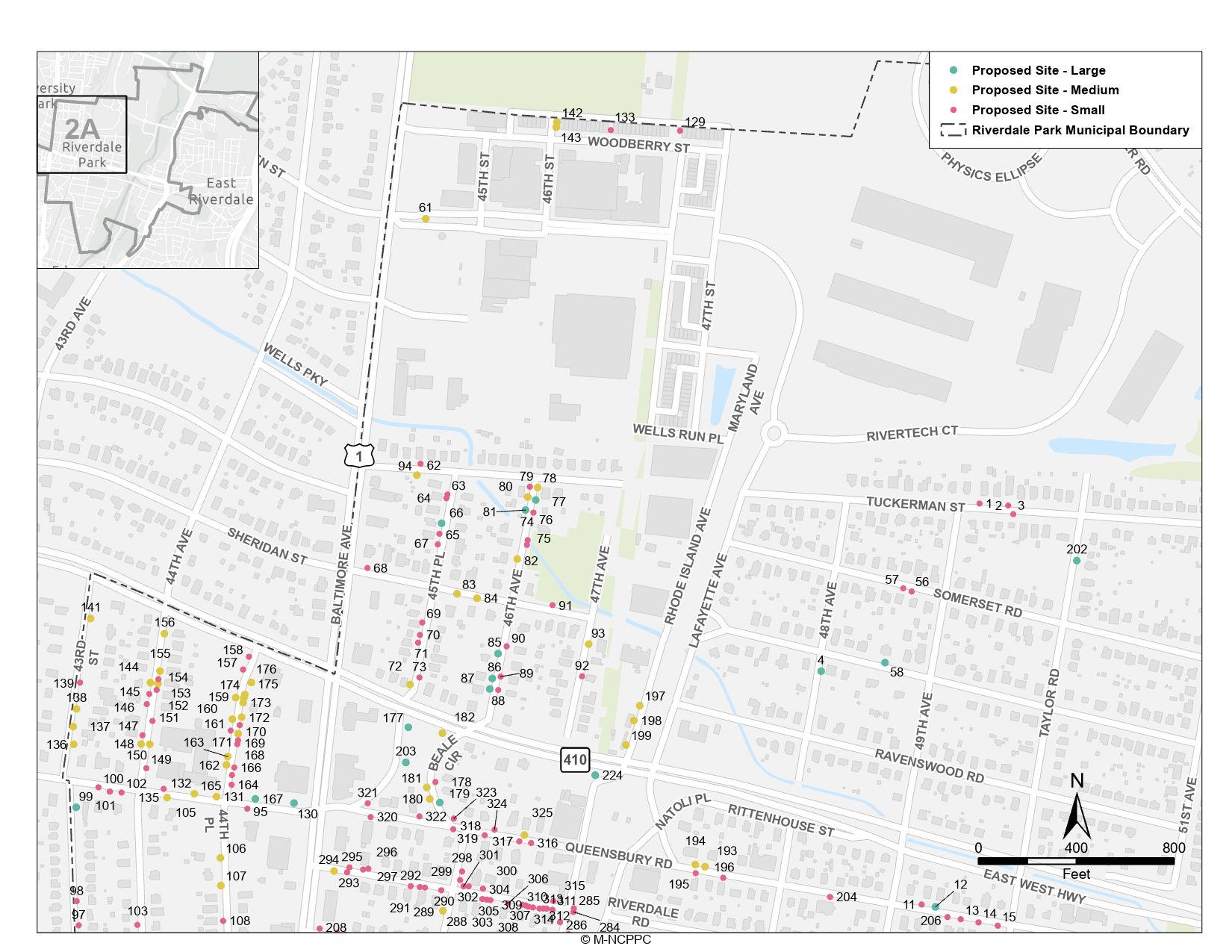
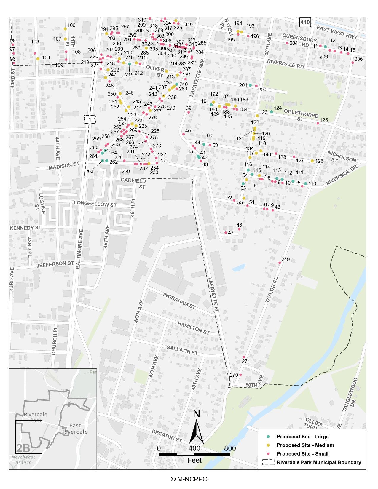
Tables 5 and 7 summarize the total observed planting spaces during the inventory. While the Tree Plotter™ software specified Large, Medium, and Small to correspond to the number of trees that may be plantable in those spaces, this plan collected information as to the size of a tree at maturity that could be planted in the location. For example, small tree planting space would likely correspond to a location with overhead utilities or a narrow tree lawn between the sidewalk and curb.
This decision is a more practical approach to infill planting in urban areas where there are not areas for large numbers of trees to be planted because of existing buildings, roads, and utilities, but instead there are opportunities to replace undesirable species or to replace trees removed as part of development activities.
Map 1. Locations of High-Priority Prunings and Removals
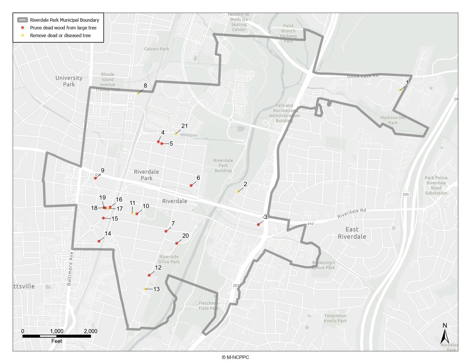
Source: base layer and municipal boundary, https://www pgatlas com Locations and field survey by Kimley-Horn/Wetlands Studies and Solutions �
A successful tree planting program includes maintenance and management of planted trees in addition to removal and replacement. In the first years following planting, regular watering and proper mulching are key maintenance activities that will encourage vigorous growth and establishment. Filling water bags, weeding, mulching, and the pruning of young trees are all appropriate levels of engagement for citizens and citizen groups to participate in supporting the Town’s urban forest.
Community-wide events can occur on Earth Day, Arbor Day, and/or Dr. Martin Luther King, Jr. Day as service projects, and during other planned dates. In addition, an adopt-a-tree program can serve as a long-term citizen commitment to care for trees planted at private residences and businesses.
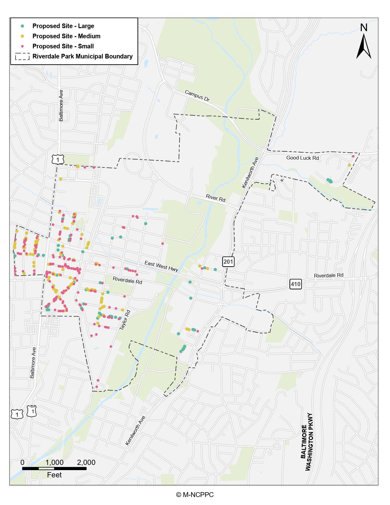
Planting trees in the over 300 planting spaces identified during the inventory would be an ambitious undertaking even if spread over several years. To reach that goal, Riverdale Park recently has received a grant from the Chesapeake Bay Trust Urban Tree
program to plant up to 150 trees in the right-of-way, on municipal property, and in a new “pocket” park near multifamily residences where open space is lacking. Pruning, weeding/mulching, and watering will likely take much of the Town resources. When more funds become available, in-fill planting should be performed throughout Town to maintain the tree replacement cycle. Plantable spaces are shown on Map 2 and are enlarged in Maps 2A, 2B, and 2C. The locations are listed in Table 7.
A three- to five-year pruning cycle is typically recommended for established trees of all sizes, but initial training of young trees can occur at the time of planting and in the immediate years following to set the tree on course to develop proper structure.
Not all newly planted trees will require pruning, but those trees that do can be pruned as part of a community engagement event, to maintain citizen engagement and cooperation. The knowledge and involvement garnered through this engagement can evolve into the planting and retention of trees on private property, increasing the Town’s total forest canopy.
Source: base layer and municipal boundary, https://www pgatlas com
Proposed sites and field survey by Kimley-Horn/Wetlands Studies and Solutions
Planting trees in the over 300 planting spaces identified during the inventory is part of a successful tree planting program in Riverdale Park. Maps 2A, 2B, and 2C carefully illustrate plantable spaces in Riverdale Park.
Source: base layer and municipal boundary, https://www pgatlas com Proposed sites and field survey by Kimley-Horn/Wetlands Studies and Solutions

Source: base layer and municipal boundary, https://www pgatlas com
Proposed sites and field survey by Kimley-Horn/Wetlands Studies and Solutions

Source: base layer and municipal boundary, https://www pgatlas com
Proposed sites and field survey by Kimley-Horn/Wetlands Studies and Solutions
When properly maintained, the lifetime value derived from trees and the urban forest can far exceed the time and money invested in their care. As the urban forest grows, the benefits enjoyed by Riverdale Park and its residents will increase as well. Inventoried trees are only a fraction of the total trees in Riverdale Park and do not include private property, those in state rights-of way,
and regional parks. This is why it is important to also incentivize private property owners to care for their trees and to plant new ones.
The Town is on its way to creating a sustainable and resilient public tree resource, and can stay on track by setting goals, updating inventory data to check progress, engaging citizens, and setting more ambitious goals once they are reached.
As a planting schedule is implemented and trees become established, the Town’s street tree population will ideally become more diverse, robust, and denser. Recommendations on pruning cycles, maintenance, and citizen engagement will be consistent. It is important to update the tree inventory using Tree Plotter™ as work is completed, so the software can provide updated species distribution and benefits estimates. This empowers Riverdale Park to self-assess the Town’s progress over time and set goals toward which to strive by following the Adaptive Management Cycle in Figure 3.
Figure 3. Adaptive Management Cycle
Prepare planting plans well enough in advance to schedule and complete stump removal in the designated area, and to select species best suited to the available sites. 1. ASSESS
4. IMPLEMENT, GAUGE, AND UPDATE
Create new planting sites, particularly in low-income neighborhoods, and work with landowners to locate new plantings on private land where no appropriate space exists in the right-of-way.
Remove stumps at the time of tree removal to increase efficiency and limit mobilization costs.
ADAPTIVE MANAGEMENT CYCLE
Annually compare the number of trees planted to the number of trees removed and the number of vacant planting sites remaining, then adjust future plantings plans accordingly. Removals and vacant sites can be updated instantly using the Tree Plotter™ software and a tablet in the field.
Annually compare the species distribution of the inventoried tree resource with the previous year after completing planting plans to monitor recommended changes in abundance.
Schedule and assign high-priority tree work so it can be completed as soon as possible instead of reactively addressing new lower priority work requests as they are received.
Include data collection such as measuring DBH and assessing condition into standard procedure for tree work and routine inspections, so changes over time can be monitored.
When a term appears in the tree inventory software it is noted in parentheses.
Air Pollution Removal
In i-Tree Eco, air pollution removal refers to the removal of ozone (O3), sulfur dioxide (SO2), nitrogen dioxide (NO2), carbon monoxide (CO), and particulate matter less than 2.5 microns (PM2.5).
Adequate Growing Space (data field)
The estimated root space available between hardscape features.
Arboriculture
The art, science, technology, and business of commercial, public, and utility tree care.
Avoided Runoff
In i-Tree Eco, avoided runoff measures the amount of surface runoff avoided when trees intercept rainfall during precipitation events.
Canker (data field)
Dead sections of bark on branches or main trunks of trees.
Canopy
Branches and foliage that make up a tree’s crown.
Canopy Cover
As seen from above, it is the area of land surface that is covered by tree canopy.
Carbon Monoxide (CO)
A colorless, odorless, highly toxic gas formed as a result of the incomplete combustion of a carbon or carbon compound.
Carbon Sequestration
The capture and storage of carbon from the Earth’s atmosphere. In i-Tree Eco, carbon sequestration is calculated as an annual functional benefit of trees.
Carbon Storage
Storage of carbon in plant tissue. In i-Tree Eco, carbon storage is calculated as a structural benefit over the lifetime of the tree.
Cavity Decay (data field)
Cavities are created when physical wounding of the trunk, branch, or branch union occurs. These wounds are then expanded by wood decaying fungi, bacteria, or wildlife.
Clean
(Secondary Maintenance need)
The tree has dead or diseased parts greater than two inches in diameter which should be removed to improve tree health, appearance, and to reduce associated risk.
Comments (data field)
Additional comments on the state of the inventoried tree. Comments may include additional defects that were significant but not the primary defect, explanations for why further inspection is needed, and other general information considered important by the inventory arborist.
Commercial (Land Use)
Land use for the buying and selling of commercial goods. This land use type includes stores, restaurants, hospitals, and other businesses which provide goods or services for a fee.
Community Forest
A population of trees and other associated vegetation that grow within a city, town, or suburb.
Condition (data field)
The general condition of each tree rated during the inventory according to categories adapted from the International Society of Arboriculture’s rating system.
Critical (data field)
General health of the tree is observed to be nearing dead, where aggressive interventions are not likely to improve the tree’s condition.
Crown Dieback (data field)
The dying of branches and branch tips generally in the upper and outer portions of the tree crown. Dieback often occurs as a sign of stress and may be associated with a new pest or disease.
Cycle
Planned length of time between vegetation maintenance activities.
Dead (Condition Rating)
A dead tree shows no signs of life.
Defect
A condition or characteristic of a tree that is structurally weak or contributes to a structural weakness.
Diameter
See Tree Size
Diameter at Breast Height (DBH)
See Tree Size.
Failure
In terms of tree management, failure is the breakage of stem or branches, or loss of mechanical support of the tree’s root system.
Fair (Condition Rating)
A fair tree has minor problems that may be corrected with time or corrective action.
Functional Benefit
In i-Tree Eco, a benefit which is due to the physiological processes carried out by trees, calculated on an annual basis.
Further Inspection (data field)
Notes that a specific tree may require an annual inspection for several years to make certain of its maintenance needs. A healthy tree obviously impacted by recent construction serves as a prime example. This tree will need annual evaluations to assess the impact of construction on its root system. Another example would be a tree with a defect requiring additional equipment for investigation.
Genus
A taxonomic category ranking below a family and above a species and generally consisting of a group of species exhibiting similar characteristics. The plural of genus is genera. In taxonomic nomenclature, the genus name is used, either alone or followed by a Latin adjective or epithet, to form the name of a species.
Geographic information system (GIS)
A technology that is used to view and analyze data from a geographic perspective. The technology is a piece of an organization’s overall information system framework. GIS links location to information (such as people to addresses, buildings to parcels, or streets within a network) and layers that information to provide a better understanding of how these interrelate.
Girdling Roots (data field)
A root that grows in a circular or spiral pattern around the trunk or at or below the soil line, gradually strangling the trunk. As roots circle the trunk, they can slow and eventually cut off the flow of sap in the tree.
Good (Condition Rating)
A tree in good condition shows no major problems.
Hardscape Damage (data field)
Damage to sidewalks, driveways, walkways, utility infrastructure, etc., caused by root growth pushing infrastructure up. Commonly seen as raised sidewalks that can be a tripping hazard or impede pedestrian passage.
Healthy (data field)
A rating of a tree’s overall condition where defects are few or not detrimental to the structural stability of the tree, pests or diseases are not present, and leaf production and color is vigorous. A tree rated as healthy will be able to withstand minor disturbances without intervention.
Improperly Installed (data field)
Trees are seen to be planted too deep or too high in the ground, at an angle, or an otherwise improper manner according to industry standards.
Improperly Mulched (data field)
Often the over application of mulch to the base of a tree that extends onto and over the root flare and up the trunk, forming a volcano-like mound. Can also refer to a lack of mulch or improper material used as mulch (i.e., grass clippings).
Mechanical Damage (data field)
Physical damage to a tree part as a result of human, wildlife, or weather events. This can include mower damage to roots, deer rub damage on the trunk, or branch breakage from falling limbs.
Memorial Tree (data field)
Tree identified as commemorative, usually with a placard or tree sign.
Minimum Approach Distance
The closest distance a qualified employee may approach an energized conductor or object.
Mulch Rings
Mulched areas surrounding the base of a planting. This reduces the likelihood of mower/mechanical injury, reduces competition from turf, and maintains a more stable root environment.
Nutrient Deficiency (data field)
Defect observation denoting leaf discoloration or other visible sign of a deficiency in the soil for proper tree growth.
Pests (data field)
Defect observation noting the presence of insects or other animals. Presence does not necessarily correlate with a negative tree rating.
Planting Failure
Loss of a recently planted tree due to injury, disease, soil or water deficiencies.
Poor Location (data field)
Defect observation noting that the tree is growing in a less-than-ideal location. This includes underneath power lines, inadequate soil volume, a shady or overly sunny location for the species, or blocking signs/road intersections.
Poor Root System (data field)
Defect observation noting problems with tree roots that may include surface roots that are susceptible to mower damage or foot traffic, eroded or damaged roots, or roots growing under sidewalks.
Public Tree Resource
See Tree Resource.
Raise (data field)
Structural maintenance recommendation whereby the process of cutting back lower branches to raise the height of the canopy.
Reduce (data field)
Structural maintenance recommendation whereby appropriate canopy reduction removes branches and stems from the outer portion of the canopy back to lateral branches.
Remove Hardware (data field)
Defect observation recommending the removal of planting stakes, guy lines, or other materials that may impact tree structure.
Serious Decline (data field)
Defect observation noting poor condition of tree including branch and crown dieback, excessive leafloss during the growing season, and broken limbs.
Thin (data field)
Structural maintenance recommendation where branches are removed to reduce branch conflicts, correct codominant stems, or provide light and wind passage through the canopy.
Training
The practice of staking and pruning developing trees to encourage healthy form and structure.
Tree Lawn
Area surrounding trees that will impact soil conditions. Managed (i.e., raked/weeded) to promote tree health.
Tree Resource
Trees providing environmental benefits to a geographic region (city/town, etc.).
Tree Size (data field)
A tree’s diameter measured to the nearest inch in 1-inch size classes at 4.5 feet above ground, also known as breast height (DBH) or diameter.
Tree Stature (Large, Small)
The final (or expected final) size of a given tree. Different species will reach different heights and crown diameter.
Urban Forest
See Community Forest
Water Bag
A device fitted around new plantings to provide consistent irrigation.
American National Standards Institute 2008. ANSI A300 (Part 1) Tree, Shrub, and Other Woody Plant Management Standard Practices (Pruning).
Coder, K.D. 1996. Identified Benefits of Community Trees in Forests. University of Georgia Cooperative Extension Service: Forest Resources Unit. Publication FOR96-39.
Heisler, G.M. 1986. Energy Savings with Trees. Journal of Arboriculture 12(5): 113-125.
Kuo, F.E. and Sullivan, W.C. 2001. Environment and Crime in the Inner City: Does Vegetation Reduce Crime? Environment and Behavior. 33(3): 343-367.
Lovasi, G.S., Quinn, J.W., Neckerman, K.M., Perzanowski M., Rundle, A. 2008. Children living in areas with more street trees have lower prevalence of asthma. Journal of Epidemiology and Community Health 62(7): 647-649.
Ordoñez, C. and Duinker, P. 2014. Assessing the vulnerability of urban forests to climate change. Environmental Reviews. 22(3): 311-321.
Richards, N.A. 1983. Diversity and Stability in a Street Tree Population. Urban Ecology 7(2): 159-171.
Santamour, F.S. 1990. Trees for Urban Planting: Diversity Uniformity, and Common Sense: US National Arboretum: Agricultural Research Service
Ulrich, R. 1984. View through Window May Influence Recovery from Surgery. Science 224: 420-422.
Ulrich, R. 1986. Human Responses to Vegetation and Landscapes. Landscape and Urban Planning 13: 29-44.
U.S. Forest Service 2003a. Benefits of Urban Trees—Urban and Community Forestry: Improving Our Quality of Life. Southern Region of Forestry Report. R8-F 71.
Wolf, K.L. 1998. Urban Nature Benefits: Psycho-Social Dimensions of People and Plants. University of Washington: College of Forest Resources Human Dimensions of the Urban Forest Fact Sheet #1.
Wolf, K.L. 1999. Grow for the Gold: Trees in Business Districts. Washington State DNR: Community Forestry Program Number 14.
Wolf, K.L. 2000. Community Image: Roadside Settings and Public Perceptions. University of Washington: College of Forest Resources. Human Dimensions of the Urban Forest Fact Sheet #10.
Wolf, K.L. 2003. Social Aspects of Urban Forestry: Public Response to the Urban Forest in Inner-City Business Districts. Journal of Arboriculture 29 (3): 117-126.
Wolf, K.L. 2007. City Trees and Property Values. Arborist News 16(4): 34-36.
This report has been prepared by an Arborist certified by the International Society of Arboriculture. Arborists are tree specialists who use their education, knowledge, training and experience to examine trees, recommend measures to enhance the beauty and health of the trees and attempt to reduce the risk of living near trees. Arborists cannot detect every condition that could possibly lead to the structural failure of a tree. Since trees are living organisms, conditions are often hidden within the tree and below ground. Arborists cannot guarantee that a tree will be healthy or safe under all circumstances, or for a specific period of time. Likewise, the results of remedial treatments cannot be guaranteed. Trees can be managed but they cannot be controlled. To live near trees is to accept some degree of risk and the only way to eliminate all risk associated with trees is to eliminate all of the trees.
Tree assessment provided by WSSI is based on visual recording at the time of inspection. Visual records do
not include testing or analysis and do not include aerial or subterranean inspection. WSSI is not responsible for discovery or identification of hidden or otherwise nonobservable conditions or risks. Records may not remain accurate after inspection due to variable deterioration of inventoried material and site disturbance. WSSI provides no warranty with respect to the fitness of the urban forest for any use or purpose whatsoever or for future outcomes of the assessed trees. Clients may choose to accept or disregard WSSI’s recommendations or to seek additional advice. WSSI’s visual inspection is confined to the designated subject tree(s) and the inspections for this project are performed in the interest of facts of the tree(s) without prejudice to or for any other service or any interested party.
We offer no opinion and do not purport to opine on the possible application of various building codes, zoning ordinances, other land use or platting regulations, environmental or health laws and other
similar statutes, laws, ordinances, code and regulations affecting the possible use and occupancy of the Property for the purpose for which it is being used, except as specifically provided above. We make no other warranties, either expressed or implied, and our report is not a recommendation to buy, sell or develop the property.
The foregoing opinions are based on applicable laws, ordinances, and regulations in effect as of the date hereof and should not be construed to be an opinion as to the matters set out herein should such laws, ordinances or regulations be modified, repealed or amended.
Any legal description provided to the consultant is assumed to be correct. No responsibility is assumed for matters legal in character nor is any opinion rendered as to the quality of any title.
WSSI can neither guarantee nor be responsible for accuracy of information provided by others, information not provided or disclosed, or the accuracy of any utility markings on site.
WSSI shall not be required to give testimony or to attend court by reason of this consultation/reports unless subsequent written arrangements are made, including payment of an additional fee for services.
This report represents the opinion of the consultant, and the consultant’s fee is in no way contingent upon the reporting of any predetermined findings.
Sketches, diagrams, graphs, photos, etc., in this report, being intended as visual aids, are not necessarily to scale and should not be construed as engineering reports or surveys.
This project was funded and managed by the Planning Assistance to Municipalities and Communities (PAMC) program, Prince George’s County Planning Department.
Lakisha Hull, AICP, LEED AP BD+C Planning Director
James Hunt, MPA Deputy Director of Operations
Tony Felts, AICP Deputy Director of Administration
Community Planning Division
Frederick Stachura, J.D. Supervisor Neighborhood Revitalization Section
Daniel Sams Planner IV, PAMC Program Manager
Anusree Nair Planner II, Project Manager
Zachary Banham Senior GIS Specialist Placemaking Section
Tamika Henderson Administrative Assistant III
Information Management Division
Nora Barenblitt GIS Specialist
Geographic Information Services Section
Michael Lancaster GIS Specialist
Geographic Information Services Section
Management Services Division
Thi-Lai Simpson Publications Design Specialist II
Wendy Irminger, * Planner III, and Zachary W. Luckin, * Planner I, Neighborhood Revitalization Section, Community Planning Division
Amie Evans, PLA, ASLA, CPSI Project Manager/Landscape Architect
Cene Ketcham Project Manager, ISA Board Certified Master Arborist Maryland Licensed Tree Expert
Luis Yanez Urban Forester
Prince George’s County Department of Public Works and Transportation
Charlie Griffith, P.E. Consultant Office of Storm Drain Maintenance
Natalie J. Cheetoo * GIS Analyst Office of Storm Drain Maintenance
Town of Riverdale Park
* Former employee