Iceland Within the Northern Atlantic
Volume 1: Geodynamics and Tectonics
1st Edition
Brigitte Van Vliet-Lanoe
Visit to download the full and correct content document: https://ebookmass.com/product/iceland-within-the-northern-atlantic-volume-1-geodyn amics-and-tectonics-1st-edition-brigitte-van-vliet-lanoe/
SCIENCES
Geoscience, Field Director – Yves Lagabrielle
Lithosphere-Asthenosphere Interactions, Subject Head – René Maury
Iceland Within the Northern Atlantic 1
Geodynamics and Tectonics
Coordinated by Brigitte Van Vliet-Lanoë
First published 2021 in Great Britain and the United States by ISTE Ltd and John Wiley & Sons, Inc.
Apart from any fair dealing for the purposes of research or private study, or criticism or review, as permitted under the Copyright, Designs and Patents Act 1988, this publication may only be reproduced, stored or transmitted, in any form or by any means, with the prior permission in writing of the publishers, or in the case of reprographic reproduction in accordance with the terms and licenses issued by the CLA. Enquiries concerning reproduction outside these terms should be sent to the publishers at the undermentioned address:
ISTE Ltd
27-37 St George’s Road
John Wiley & Sons, Inc.
111 River Street London SW19 4EU
Hoboken, NJ 07030
UK USA
www.iste.co.uk
www.wiley.com
© ISTE Ltd 2021
The rights of Brigitte Van Vliet-Lanoë to be identified as the author of this work have been asserted by her in accordance with the Copyright, Designs and Patents Act 1988.
Library of Congress Control Number: 2021932010
British Library Cataloguing-in-Publication Data
A CIP record for this book is available from the British Library
ISBN 978-1-78945-014-9
ERC code:
PE10 Earth System Science
PE10_5 Geology, tectonics, volcanology
PE10_13 Physical geography
PE10_18 Cryosphere, dynamics of snow and ice cover, sea ice, permafrosts and ice sheets
σ1, σ2 and σ3
σHmax
List of Abbreviations
Maximum, intermediate and minimum principal stresses of the stress tensor
Maximum horizontal stress
A AMO Atlantic multidecadal oscillation
B
BTVP British Tertiary Volcanic Province
C
CGFZ Charlie–Gibbs Fracture Zone
CGPS Communicative Global Positioning System
D
DL Dalvik Line
DMM Depleted MORB mantle
DO Dansgaard–Oeschger event
Iceland Within the Northern Atlantic 1, coordinated by Brigitte VAN VLIET-LANOË. © ISTE Ltd 2021.
x Iceland Within the Northern Atlantic 1
DSOW Denmark Strait overflow water
DTM Digital terrain model
E
E-MORB Enriched mid-ocean ridge basalts
EM Enriched mantle
EUR Europe
EVZ East Volcanic Zone
F
FLF Flat-lying flows
G
GEBCO General Bathymetric Chart of the Oceans
GIA Glacio-isostatic adjustment
GIFR
Greenland–Iceland–Faroe Ridge
GIR Greenland–Iceland Ridge
GL Grimsey Line
GPS Global Positioning System
H
HFF Húsavík-Flatey Fault
HIMU High Mu mantle (Mu = U/Pb)
List of Abbreviations
I
ICPMS Inductively coupled plasma mass spectrometry
IFR Iceland–Faroe Ridge
IGS International GPS Service
IMO Icelandic Meteorological Office (Veðurstofa Íslands)
InSAR Interferometric Synthetic Aperture Radar
IRD Ice-rafted detritus
ISOW Iceland–Scotland Overflow Water
ÍSNET GPS Network surveys of the National Land Survey of Iceland (Landmælingar Íslands)
J
JMFZ Jan Mayen Fracture Zone
K
KR Kolbeinsey Ridge
L
LBA Labrador–Baffin axis
LGM Last Glacial Maximum (extension)
LIP Large igneous provinces
M
M or MW Moment magnitude
MAR Mid-Atlantic Ridge
xii Iceland Within the Northern Atlantic 1
Mb Body-wave magnitude
ML Local magnitude
MS Surface-wave magnitude
N
N-MORB Normal mid-ocean ridge basalts (depleted)
NADW North Atlantic Deep Water
NAIP North Atlantic Igneous Province
NAM North America
NEIC National Earthquake Information Center (United States)
NGRIP North Greenland Ice Core Project
NVZ North Volcanic Zone
O
OIB Ocean island basalts
OSC Overlapping spreading center
R
RP Reykjanes Peninsula
RR Reykjanes Ridge
S
SDRs Seaward-dipping reflectors
SIL South Iceland Lowland network
SISZ South Iceland Seismic Zone
T
TFZ Tjörnes Fracture Zone
U
USGS United States Geological Survey
W
WVZ West Volcanic Zone
Preface
Brigitte VAN VLIET-LANOË and Françoise BERGERAT
This collective work is the logical conclusion of more than 30 years of French research in Iceland, with the support of various programs and institutions. It has also benefitted from the contribution of a CNRS Thematic School on Iceland, which was held in Brest in 2010 and which was strongly impacted by the eruption of Eyjafjallajökull. This book is the fruit of the work of a group of complementary researchers who are very fond of Iceland. Our thoughts turn to Jacques Angelier who left this basaltic ship a little too early. There are multiple authors to each chapter –with a principal author for each one – in order to provide a multidisciplinary approach to the discussed scientific problems and take into account all our publications up to the most recent ones (2019–2020).
French research in Iceland began in the mid-1980s, initiated by Françoise Bergerat (Sorbonne Université, formerly Université Pierre et Marie Curie, in Paris) in search of an “emerging oceanic ridge”, in collaboration with Jacques Angelier†, then Catherine Homberg Very quickly, this collaboration was extended to Icelandic colleagues, Águst Guðmundsson (London), Kristjan Sæmundsson, Ragnar Stefánsson and Sigurdur Rögnvaldsson †. The first work focused on the analysis of brittle deformations and then turned to sismotectonics.
Iceland Within the Northern Atlantic 1, coordinated by Brigitte VAN VLIET-LANOË. © ISTE Ltd 2021.
This work was then supplemented, from the 2000s, by the geodetic campaigns of the team from the Université de Savoie in Chambéry led by Thierry Villemin in collaboration with Halldór Geirsson and his group. At the beginning of the 1990s, Laurent Geoffroy began (in Paris) work on the Thule basaltic provinces (Scotland, Ireland, Faroe Islands), continued from the 2000s (at the Université du Maine, in Le Mans) on the other side of the Atlantic, in Greenland. The analysis of the morphology of Iceland began in the mid-1990s at the Université de Rennes-I, with Olivier Dauteuil and Brigitte Van Vliet-Lanoë, and then extended to the neighboring ocean in relation to volcanism and the evolution of the North Atlantic. At the same time, the Neogene and Quaternary climatic history of the island, recorded by stratigraphy, was consolidated with dating carried out by Hervé Guillou and his colleagues and by geochemistry carried out at the Université de Bretagne Occidentale, in Brest, in close collaboration with Águst Guðmundsson (Hafnafjördur), Kristjan Sæmundsson and Helgi Björnsson’s team. The last stage of this work is currently being developed in the Géosciences Océan laboratory in Brest, with Laurent Geoffroy and René Maury. It concerns the evolution of the North Atlantic based on Icelandic and Greenlandic data.
The material and logistical support of the Icelandic authorities proved to be very constructive both for field work and for data acquisition and sharing: IMO (Veðurstofa Íslands/Icelandic Meteorological Office); ISOR (Íslenskar orkurannsóknir/Icelandic energy research), formerly Orkustofnun (National Energy Authority); Landsvirkjun (National Power Company) and Vatnajökull National Park. This research would not have been as fruitful without the physical and intellectual help of all our students, at Master’s level and/or with their thesis works: Olivier Bourgeois, Magalie Bellou, Jean-Christophe Embry, Loïc Fourel, Sebastian Garcia, Guillaume Gosselin, Solène Guégan, Romain Plateaux, Lionel Sonnette, Anne Sophie Van Cauwenberge, Ségolène Verrier and Audrey Wayolle.
Finally, this work was made possible because of the assistance of the French Embassy in Iceland and funding from the European Commission, 4th and 5th PCRD (PRENLAB-1 and -2, PREPARED and SMSITES programs); the Paul Émile Victor Institute (IPEV), formerly the Institut français pour la recherche et la technologie
polaires (IFRTP) (Arctic Program 316); the Icelandic Ministry of Education; and the French Ministry of Foreign Affairs (Franco-Icelandic scientific and cultural collaboration program).
We also thank Bernadette Coleno, Marion Jaud, Laurent Gernigon and Alexandre Lethiers for their contributions to the figures in this volume.
February 2021
Introduction
For color versions of the figures in this Introduction see, www.iste.co.uk/vanvliet/iceland1.zip.
Iceland Within the Northern Atlantic 1, coordinated by Brigitte VAN VLIET-LANOË. © ISTE Ltd 2021.
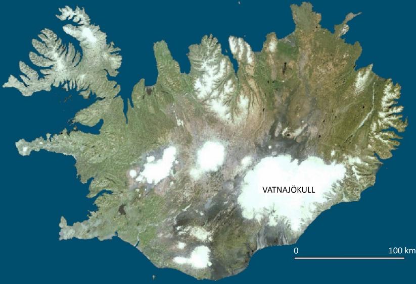
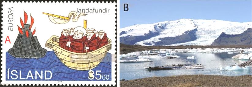
Brigitte VAN VLIET-LANOË and René MAURY Figure I.1. Iceland from Space (document Geographical Institute of Iceland/Landmælingar Ísland [LMIs])Iceland (Figure I.1), a young and isolated island in the middle of the Atlantic Ocean, has only very recently been discovered in terms of the scale of human history. Irish monks (the papars) passed from island to island in their curraghs (Figure I.2) via the Shetland Islands and the Faroe Islands to evangelize the legendary Hyperborea. These journeys took place as early as the 6th century, a period with cold volcanic winters.
The papars discovered a world of fire and ice, the gates of hell. They settled in round peat-covered huts and dug shovel caves in the consolidated sandy interglacial formations in the south of the island.
Vliet-Lanoë©)
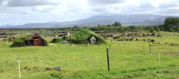
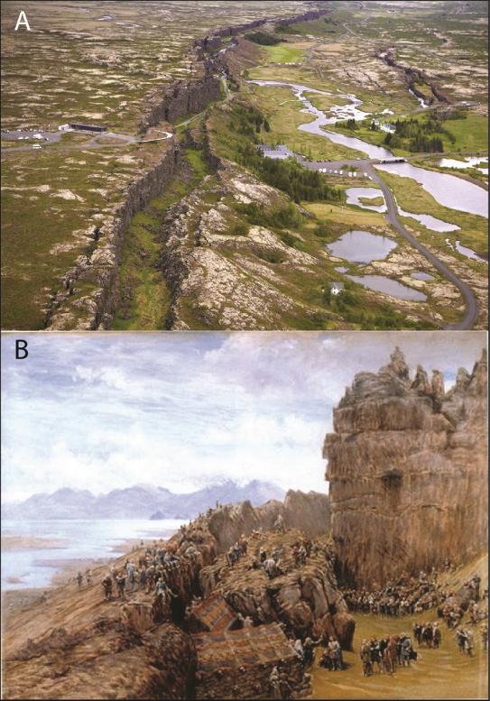
Two hundred years later, the Vikings, warriors but also more than anything farmers in search of cultivable land (Figure I.3), settled in the south and west of the island from 860 AD on wooded land made fertile by thick layers of volcanic loess. This is the landmana of the Icelandic sagas. They installed their parliament, the Alþing, around 900 AD, in a remarkable site (Figure I.4), which became a high place of plate tectonics, the Þingvellir graben, the boundary between the European and American plates.
These fertile lands were surmounted for at least 400,000 years by a fire monster, the Hekla volcano (Figure I.5). Its Plinian eruption in 1104 AD (H1, volcanic explosivity index of 5) destroyed many Viking settlements in the Rangavellir, not only by falling pumice and gas but also by the associated glacial megafloods, the jökulhlaups, submerging the Þjorsárdalur with a wave of muddy water more than 25 m high. At that time, the Hekla must have been more ice-covered than it is today.

Despite the island’s long isolation from continental Europe, there is a lot of information about its history. Indeed, Icelanders have jealously preserved their language and ancient books, including the famous sagas, and have often proved to be great writers and avid readers, even on isolated farms.
In addition to their literary and historical interest, the sagas represent a source of exceptional paleo-environmental information on a period whose climatic evolution was very complex: the Medieval Optimum and the climatic degradation that followed. The University of Iceland was founded in 1911 and, due to its special nature, Iceland is the country with the highest proportion of geologists and especially volcanologists among its population.
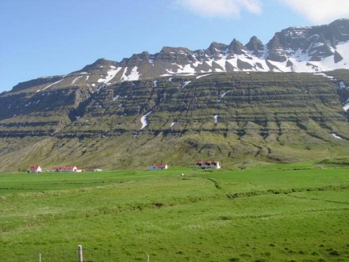
Iceland is a land of fire and ice, still sparsely populated (about 350,000 inhabitants in 2020), prized by tourists for its “unspoiled”, photogenic character and its many natural wonders, although Viking colonization quickly made the forest disappear. But recent tourist development has also caused an invasion of 4×4 vehicles, brand new hotels and vacation huts, raising the standard of living of the population, but gradually destroying a natural heritage – including the geological heritage – surprisingly well preserved until the early 21st century. Industrial development (geothermal, hydroelectricity and electrometallurgy) kept the population in the peripheral sectors of the island and above all modified the landscape of the coastal zones. Whatever one does or looks at in Iceland is de facto connected to the geological history of the island (Figure I.6).
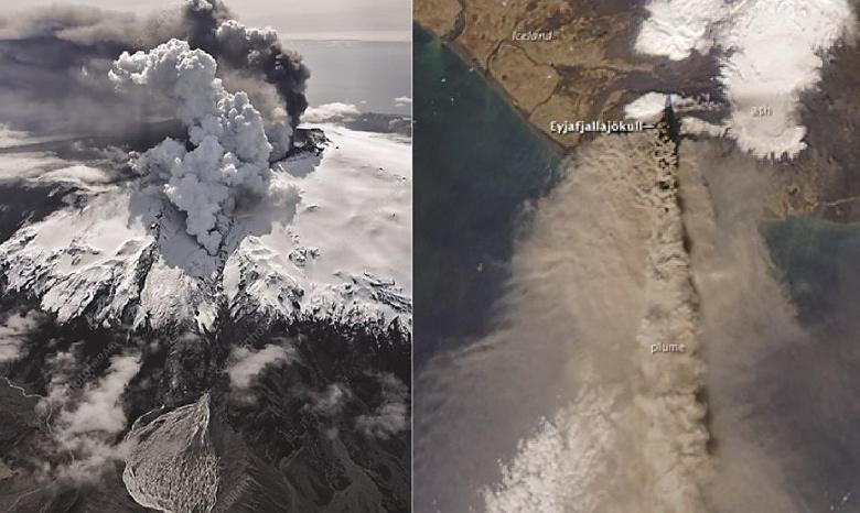
Despite its remoteness, Iceland is a land that directly influences Western Europe through its position in the north-central Atlantic, as a beacon of the Gulf Stream and thermohaline circulation, or through its meteorological depression. But it is also a
land consisting mainly of layered basaltic piles, still active from a tectonic and volcanic point of view. We were reminded of it by the last eruption of the Eyjafjallajökull (March–October 2010) with its plume of ash that invaded Europe and disrupted intercontinental commercial flights (Figures I.7 and I.8).
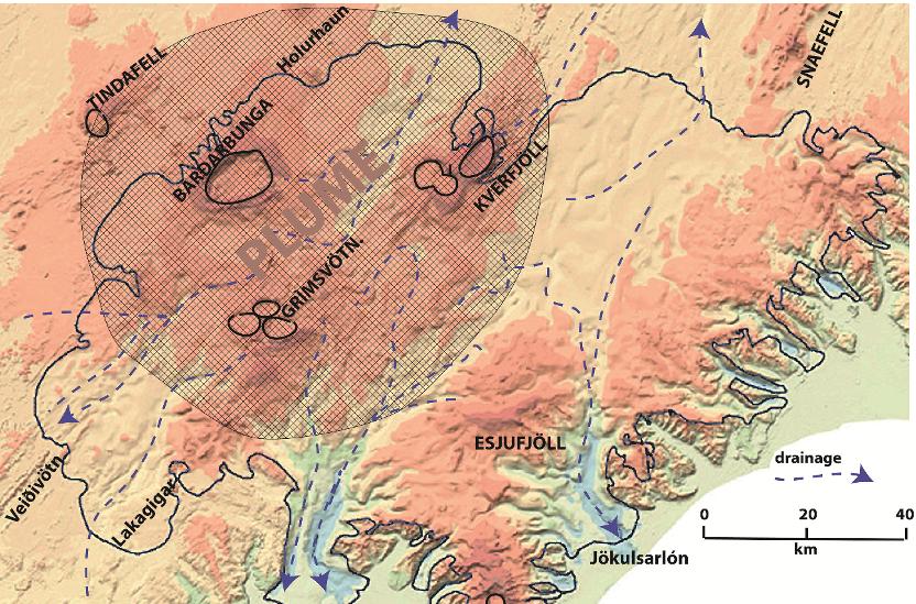
The glaciers are located on volcanic edifices, considered to be at least Quaternary. The largest ice cap, the Vatnajökull, rests on some of the most active volcanoes of the island, located above the summit of a deep magma plume.
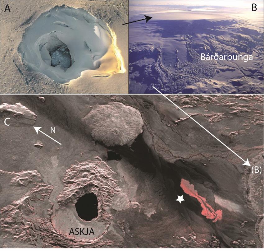
Bárðarbunga (Figure I.9) is one of the volcanoes found above the Icelandic hotspot and is located on the western margin of the present Vatnajökull ice cap.
The most recent eruption of this volcano (August 2014–February 2015; Figure I.10) was linked to the draining of a magma chamber located 12 km below the caldera, following the climate driven melting of the cap (about 1 m/year).
To the northwest, the most impressive lava flow since the 18th century, the Holhurhaun flow, occurred along a fracture line, in association with swarms of earthquakes that stretched to the Askja volcano in the north. The previous eruption, that of Veiðivötn, had flown toward the south in 1747, awakening the Torfa volcano at the same time.
The Bárðarbunga is also a source for jökulhlaups or megafloods, resulting from the melting of the glaciers by the heat of the lava emitted and which mostly flow toward the north.
Another major volcanic structure is located in the center of the ice cap, directly above the top of the mantle plume: it is the triple caldera of Grímsvötn (Figures I.9 and I.11), which emitted the vast majority of basaltic tephra that hide the glaciers and reach the lands surrounding the North Atlantic.
The most famous is the Saksunarvatn tephra splayed around 10,200 years cal BP. This volcano is never at rest; its current eruptive frequency is about 10 years and it also remained continuously active during the Ice Age, but with a lower frequency.
It is mainly responsible for the formation of subglacial lakes and is at the origin of most of the jökulhlaups that gully the emissaries of the Vatnajökull cap (Figures I.12 and I.13). At present, these floods mainly destroy road infrastructures such as the Main Highway (N1).
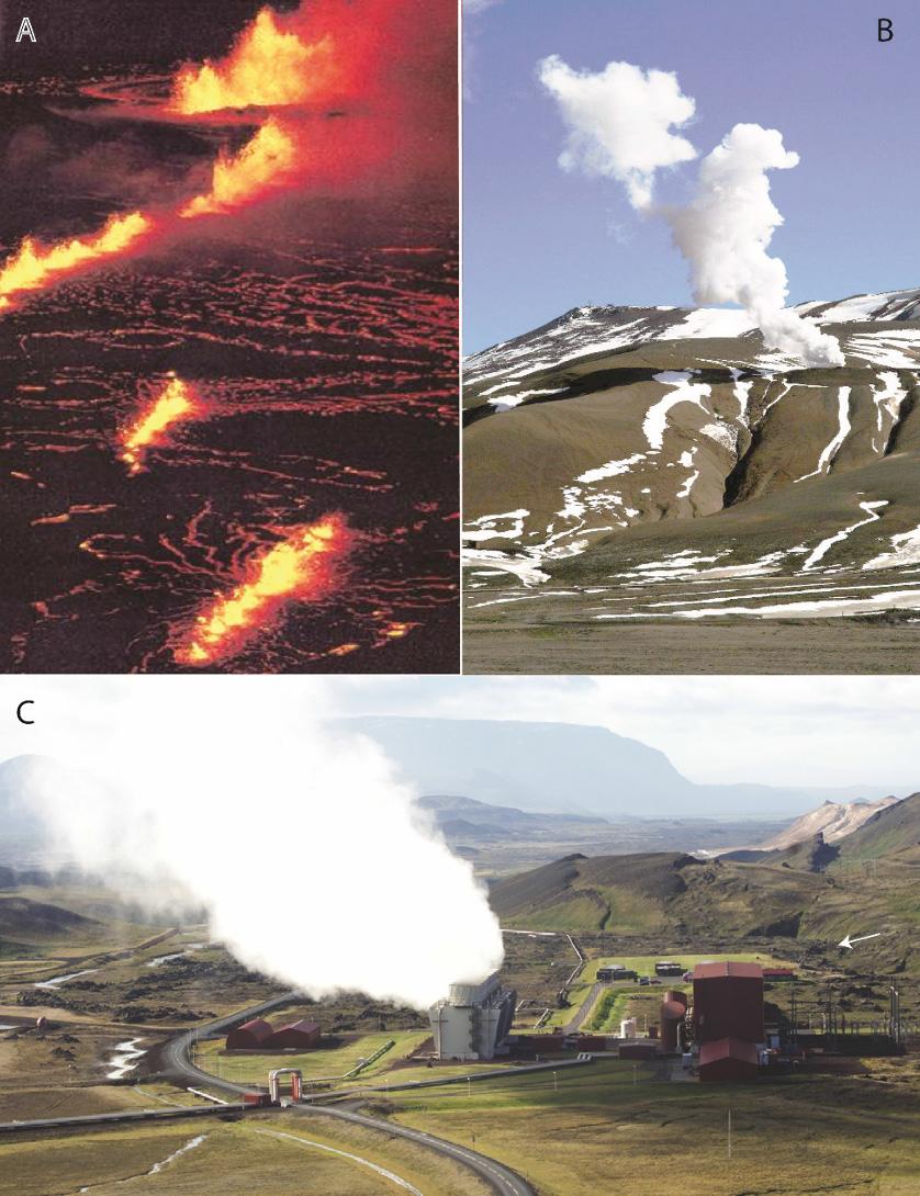
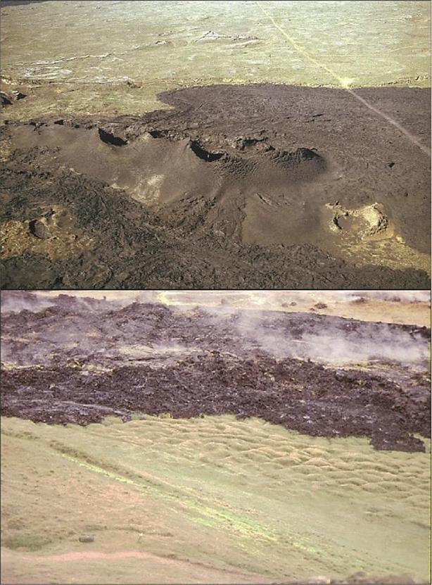
In northern Iceland, volcanic activity is also significant, in association with the northern rift. Many geothermal fields are exploited there, such as the Krafla field northeast of Lake Myvatn (Figures I.14 and I.15).
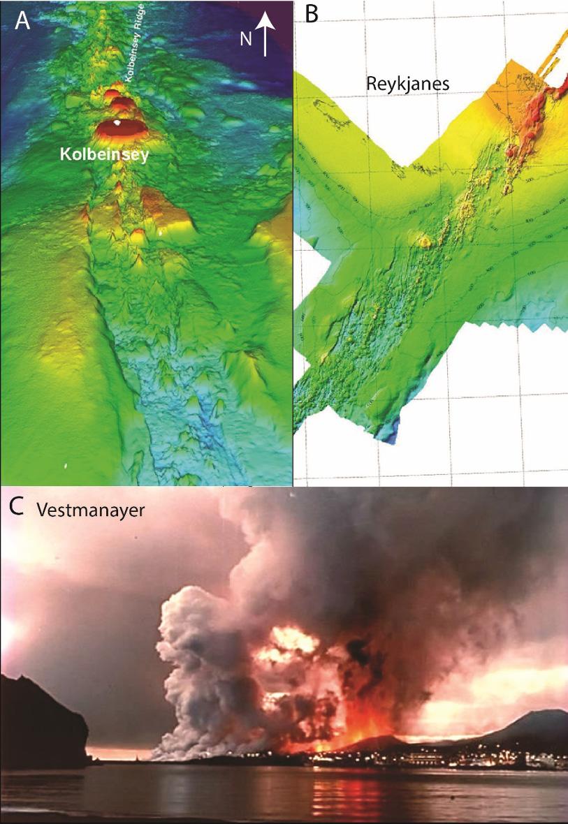
This volcanic activity also occurs at sea, both in the north in the Kolbeinsey Ridge and its intermittent island (white point in Figure I.16(A)) and in the southwest along the Reykjanes Ridge, or in the Vestmann Islands, a southern extension of the East Volcanic Zone.
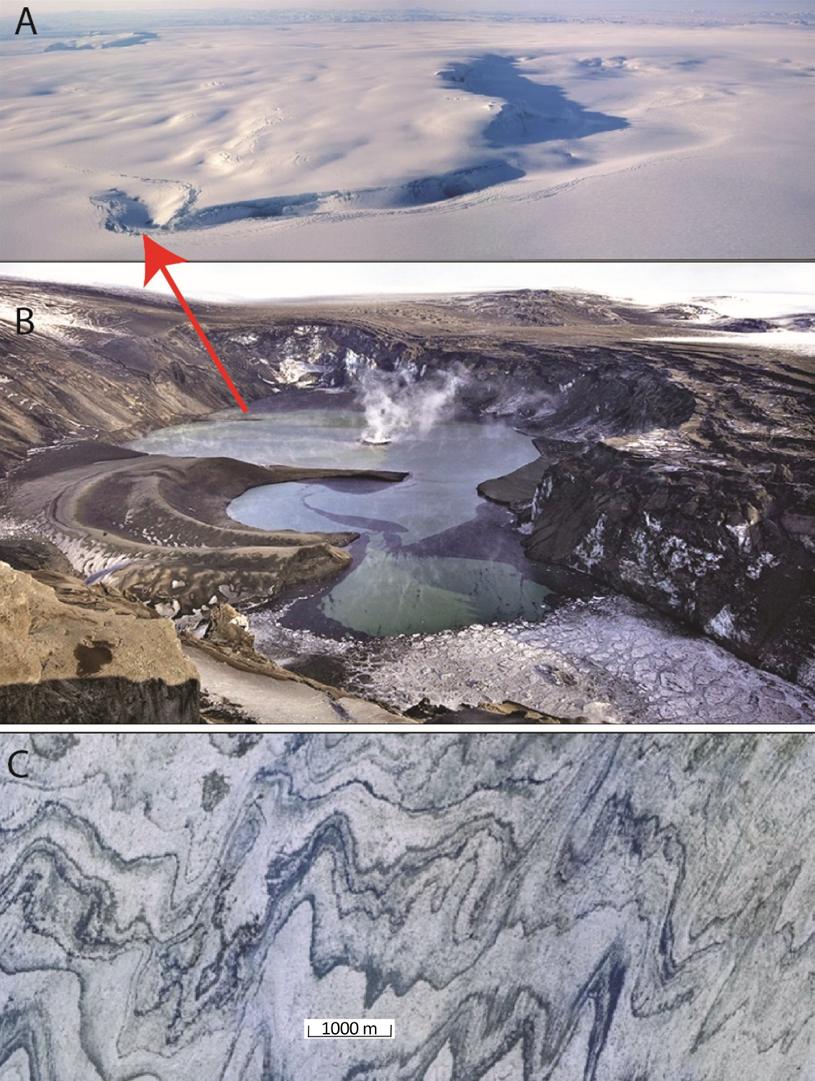
Figure I.12. The Grìmsvötn volcano. (A) Initiation of the northward flow associated with a collapse of the ice mass (sun to the west), which led to the great jökulhlaup of November 1996 (Oddur Sigurðsson©). (B) Grimsvötn crater at the end of the 2011 eruption (Dima Moiseenko©). (C) Interstratified and deformed basaltic tephras in the terminal glacier tongue of Brúarjökull (LMIs)
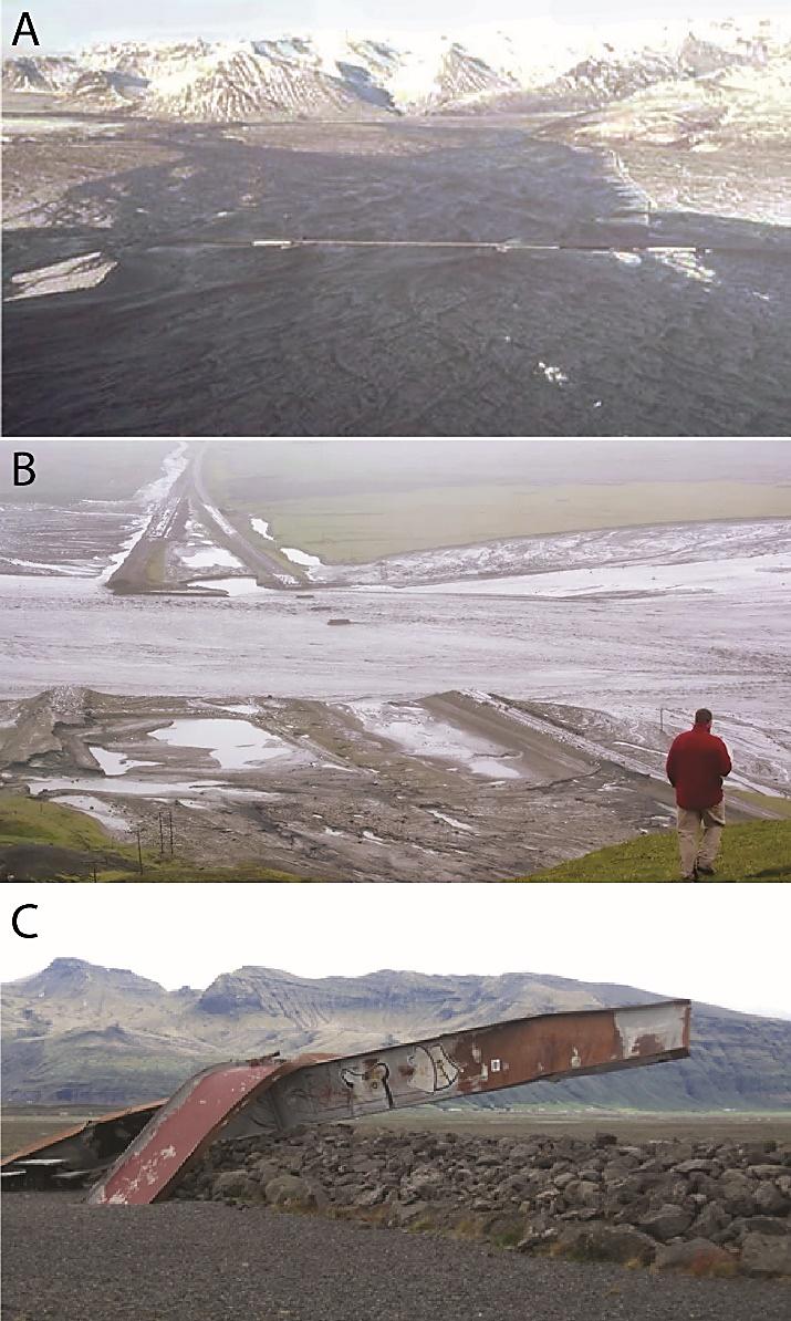
Figure I.13. (A) The jökulhlaups of the Skafta River from the Grimsvötn in 1996 (M.T. Gudmundsson©) and (B) Main Highway (N1) in 2011 (Veðurstofa Íslands©), frequently repaired since 1970, with (C) the jökulhlaup memorial of November 1996: two enormous pieces of the metal deck of the old bridge, twisted like common wires (Françoise Bergerat©)
The latter were the locus of a first submarine eruption in 1963 (building of the Surtsey volcano), then of a fissural eruption (followed by a strombolian phase) partially destroying the town of Vestmanayer on the main island of Heimaey in 1973.
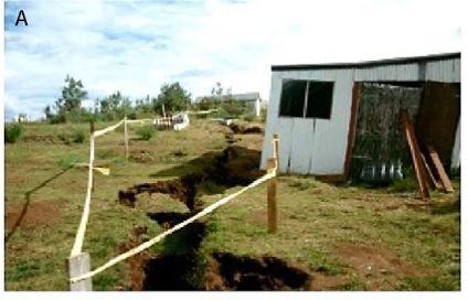
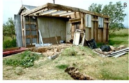
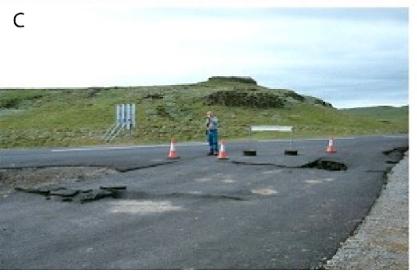
In relation to volcanic activity and especially to tectonic activity, seismicity is permanent in Iceland and major earthquakes have regularly occurred, particularly in the northern peninsulas (Húsavík region) and in the whole south of the island. When crossing the lava fields between Hveragerði and the Hekla, many remarkably preserved traces of major historical earthquakes (M > 6) can be observed (Figure I.17).
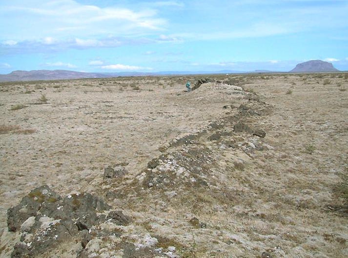
If in the north of the island the current earthquakes occur mainly offshore, the Húsavík and Kopasker agglomerations are however far from being sheltered from a significant seismic event, and in the south, several major earthquakes have occurred very recently (Mw 6–7; June 2000, May 2008).
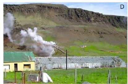
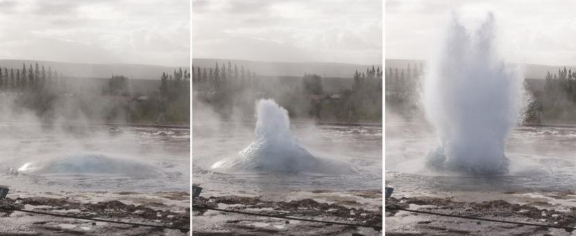
While Icelandic houses are relatively insensitive to earthquakes (Figure I.18), the same cannot be said for road infrastructure or greenhouses. The temporary rise or fall of water tables or lakes is frequent, reactivating or deactivating geysers and causing fluid escapes. This is particularly the case in the Hveragerði or Geysir region: Strokkur is currently the most active and Great Geysir is currently intermittent (Figure I.19).
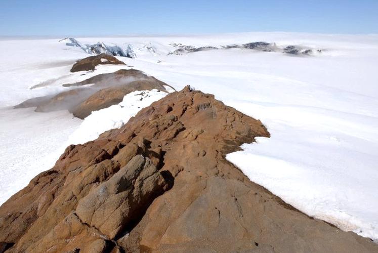
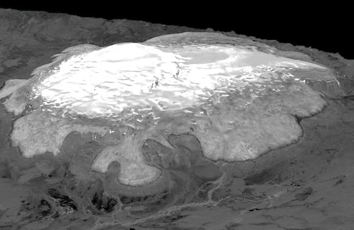
The cold pole of Iceland is represented by its glaciers, currently relatively little extended but which covered practically all the island at the time of the last glaciation, inhibiting the activity of a great majority of the volcanoes. Most of the time, they settled at the top of the volcanic edifices constituting the high points of the island such as Vatnajökull (2,009 m at Bárðarbunga) or Hofsjökull (1,765 m at Habunga; Figure I.20).
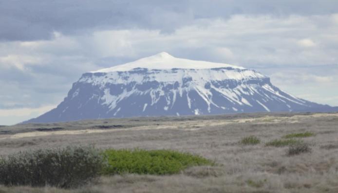
These glaciers have profoundly carved the island since the Neogene, with deep glacial valleys, ice-smoothed or striated rocks, countless drumlins and large areas of abandoned glacial sediments on the central plateau, especially around the Kerlingarfjöll (Figure I.21). Some volcanoes have typically subglacial morphologies, such as tabular volcanoes or tuyas, the best known of which is Herðubreið (Figure I.22). Others form alignments of ridges, the tindar, which formed at the margin of the melting caps (Figure I.23).
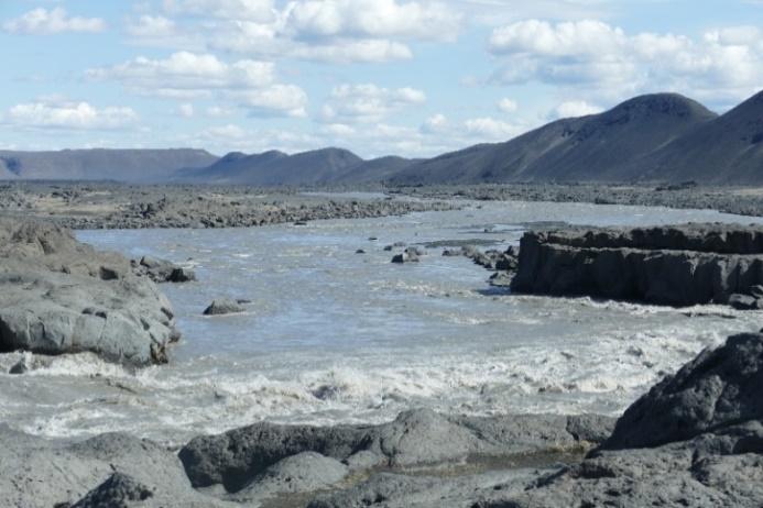
The waters from these glaciers have also shaped canyons with huge waterfalls, on powerful, gray and loaded water rivers, the jökullsá (Figures I.23 and I.24). These waters are currently collected for an important hydroelectric production with mainly industrial purposes (aluminum and rare metals extracted from imported ores). This resource accounts for 72% of Iceland’s electricity production.
Various cap outlets are currently being developed and managed, with water stored in very large dams, generally superimposed on the same course and designed to resist jökulhlaups of interglacial rank. Global warming in recent decades and potentially induced volcanism are likely to call this policy into question.
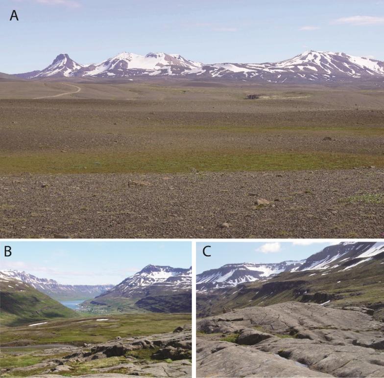
Figure I.21. (A) The Kerlingarfjöll surrounded by its glacial desert. (B) Perched upper cirque and (C) ice-smoothed rocks of the eastern fjords (Mjóifjörður, south of Seiðifjörður) (Brigitte Van Vliet-Lanoë©)