500-year cycle of extreme earthquakes in South-Eastern Turkey
Where is the modernity when we need it?
500-year cycle of extreme earthquakes in South-Eastern Turkey
Master’s Dissertation
Reading: Architecture can be read (AR7107_ALL_TY13_23)
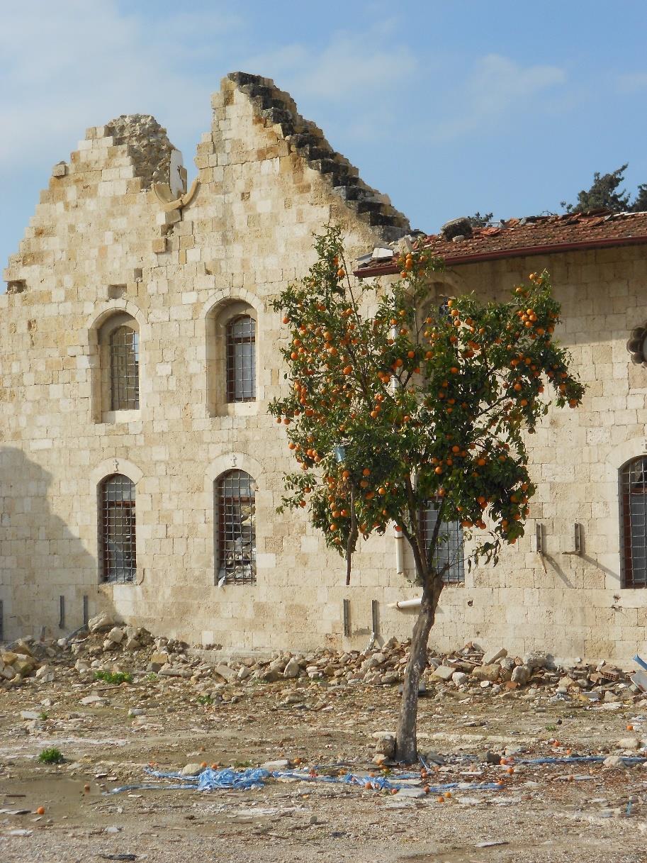
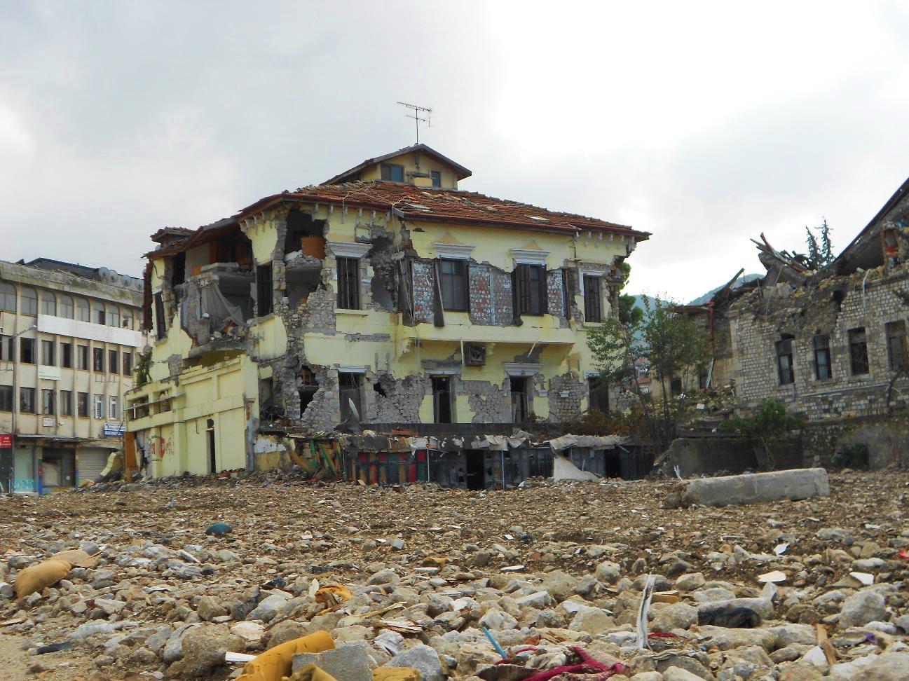
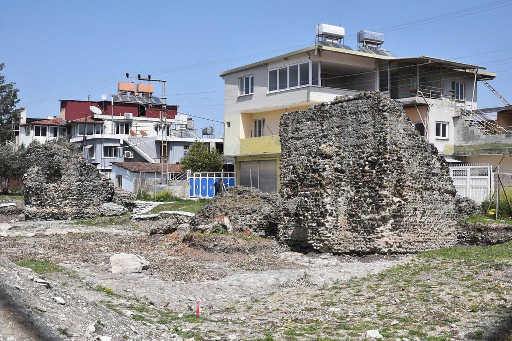
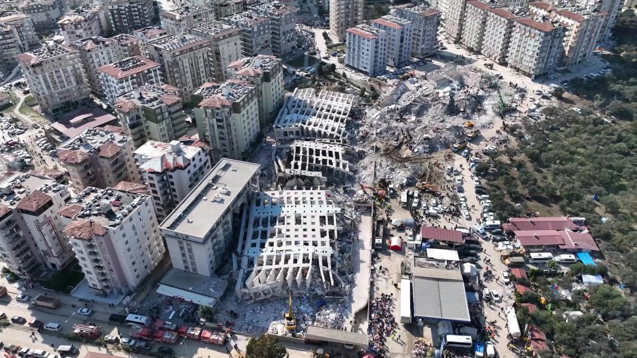
Figure 1: Destroyed city centre of Hatay. Source: Melis Yürekli, 2023
Melis Yürekli
Introduction
This dissertation will focus on earthquakes from a social and technical perspective, also explaining the aftermath. Earthquakes are unavoidable natural disasters for which we can be prepared by using up-to-date techniques. Some countries are more disadvantaged than others because of their proximity to the tectonic fault lines. The usage of modern technologies and building techniques can help us prevent the catastrophic consequences of these natural disasters.
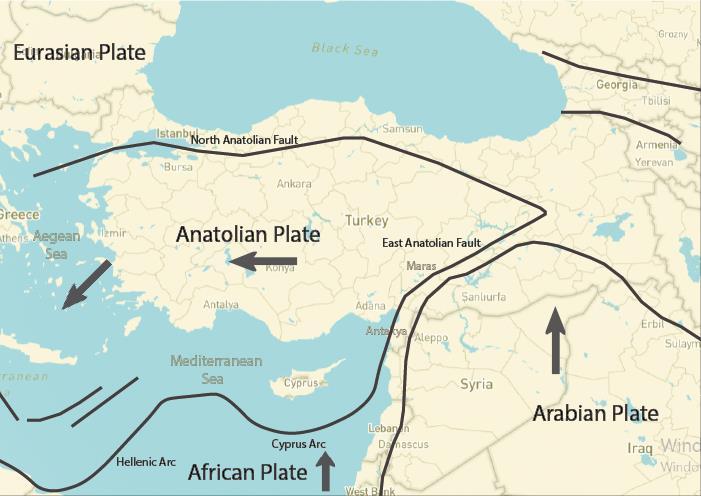
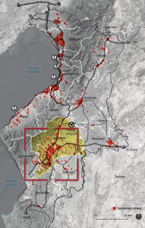
Turkey is one of the most seismically active and complex earthquake-prone countries. This country sits mainly on the Anatolian Tectonic Plate, located at the junction of the African, Arabian and Eurasian plates. The movement of the active plates results in hundreds of earthquakes of various magnitudes each month. Five destructive earthquakes have occurred in Turkey since 1950. These earthquakes happened in 1971 in Bingöl, in 2020 in İzmir, in 2011 in Van, in 1999 in Izmit and in 2023 twice on the same day in Kahramanmaraş with magnitudes of 6.9, 7.0, 7.1, 7.6, 7.6/7.7 respectively. (Azarak, 2023)
This dissertation will mainly concentrate on the most recent earthquake in 2023. On 6th February, two large earthquakes with significant magnitudes struck the Pazarcık and Elbistan districts of the south-eastern city of Kahramanmaraş This study will investigate the political and ethical situation in Turkey that led building contractors to abandon modern earthquake-resistant building technologies, which could otherwise have helped prevent the high death tolls and the destruction of the cities Where is the modernity when we need it?
The first ever-known earthquake in the region happened in 115 AD, the third deadliest earthquake in history with a death toll of 260,000 during Imperial Rome under the rule of Trojan (Cassius, 235) After that, it was followed by another earthquake 400 years later, in 526. It was the fourth deadliest earthquake, with a death toll of 250,000 (Malalas, 578) Quakes continued to recur every 500 years or so and subsequently caused disasters
Figure 2 : Tectonic map showing the three active faults. The red line shows the area of impact. Created by Yürekli (2023), based on AFAD
in 1114, 1513 and 2023. (Ambraseys, 1989) An exhaustive analysis of the recurring 500-year earthquakes in Antakya will be undertaken in the first part of the study. The study will also include that year's population, technology, damage, and living conditions, comparing its consequences to the other earthquakes. After completing the analysis, the dissertation will examine high-tech and low-tech building techniques used in earthquake-prone countries like China, Indonesia and Japan that could prevent disastrous consequences of an upcoming earthquake in 500 years.
The second part of the dissertation will focus on recovery, resettlement, and reconstruction in the aftermath of an earthquake by exploring some of the most destructive earthquakes, such as Lisbon, Los Angeles etc. This segment investigates the immediate aftermath and will focus on post-natural disaster crisis management. It will examine the government’s response, disaster procedures, aid distribution and worldwide emergency cycles, including the World Health Organization’s and United Nations' aid procedure schemes.
The second part will mainly be about the city's future, detailing how an architect can effect positive change by restoring the city’s damaged urban fabric It will explore the timeline, the budget of the processes, its cultural impact, how the earthquake affects people and the demographic impact of temporary accommodation by scrutinising several shelters designed by world-famous architects such as Shigeru Ban.
Part 1: Earthquakes in South-Eastern Turkey Over Time
General information about Turkey’s past earthquakes
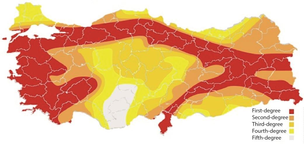
Turkey is located at the junction of the Arabian, African and Eurasian tectonic plates The faults are called the North, Western and Eastern Anatolian Fault Lines. The energy accumulation between tectonic plates gets released as movements result in earthquakes along the fault line (Palutoğlu and Şaşmaz, 2017) The country is divided into five seismic regions. The places where the three main active fault lines pass and the immediate surroundings of these places are classified as zones I and II, which are considered first-degree earthquake zones. It’s also known as the active fault area, comprising 66% of the country's surface area, where 71% of Turkey's population lives. (Eyidoğan and Güçlü, 1993)
rekli
The North Anatolian Fault Line (NAFL) runs horizontally across northern Turkey from east to west and extends from the Saros Gulf, Izmit Gulf, Adapazarı, Düzce, Bolu, Amasya, Erzincan, and Lake Van It is one of the most active strike-slip faults (when the earth moves parallel to the fracture) globally. Turkey's most destructive earthquakes occurred in this zone: Erzincan in 1992, Golcuk in 1999 and Van in 2011. (Utkucu et al., 2023)
One of the most significant earthquakes in Turkey’s history was the Golcuk earthquake in August 1999, which had a magnitude of 7.4 and lasted less than a minute at 3 am local time. It caused significant damage in Istanbul, Kocaeli, Yalova and Bursa. It is the second most destructive earthquake in the Turkish Republic’s history, leaving 250,000 people homeless. The death toll was 17,500 and the number injured total 44,000. More than 133,000 buildings were damaged and significant parts of the cities were destroyed. (Altındal and Konak, 2002) The damage was estimated at 23 billion US dollars. After the earthquake, the Turkish government introduced a tax known as the Special Communications Tax or ‘earthquake tax’. The government accepted this tax proposal in November 1999. At first, it was intended as a temporary measure, but in time, it became permanent to prevent future earthquake-related damage. In 23 years, approximately 88 billion TL was collected through this tax. (Bakır, 2023)
The Western Anatolian Fault Line (WAFL) extends through Western Anatolia on the Aegean coast. Other devastating earthquakes in this zone include those in Gediz in 1970 and Dinar in 1995.
The Eastern Anatolian Fault Line (EAFL) merges with the North Anatolian Fault Line in the direction of Hatay, Kahramanmaraş, Malatya and Bingöl. The region has a long history of destructive earthquakes stretching back to
Figure 3 : Turkey earthquake risk map. Edited by Yü
(2023), based on AFAD
the Roman Empire. These reoccurring earthquakes happen every 500 years or so. The earliest known earthquake in the area was in 115 AD, which is the third deadliest earthquake in the world’s history, killing more than 260,000 people. Other major instances followed in 526, 1114, 1513, 1872, and 2023. (Ambraseys, 1989)
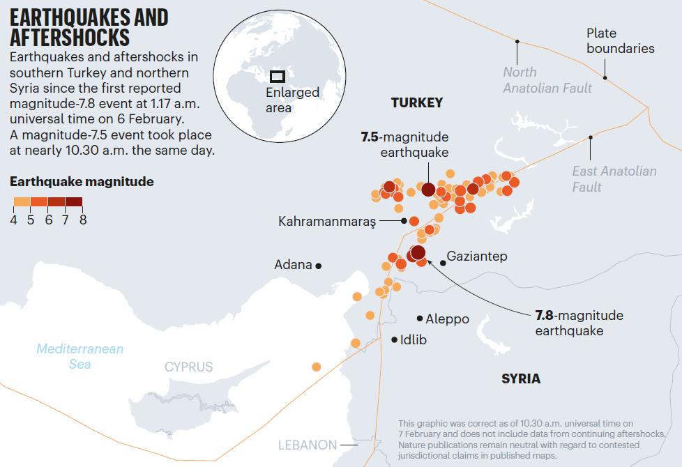
The catastrophic earthquakes in 2023 happened on this fault centred in Pazarcık, Kahramanmaraş They occurred at 04:17 and 13:24 on the same day with magnitudes of 7.8 and 7.6 on the Moment Magnitude Scale (MMS). Turkey and the Anatolian Plate moved 3 meters to the east as a result. There were more than 200 aftershocks. At least 55,000 people died, 130,000 people were injured, and 3.2 million people were displaced. (Naddaf, 2023) The fatalities and injuries were caused mainly by collapsing structures, often as some attempted to rescue loved ones from the rubble. Other reasons attributable to the high death toll included the delayed and uncoordinated response of certain local rescue efforts as well as unforgiving weather conditions, which included snowfall The search and rescue teams were at the site for 300 hours. (Utkucu et al., 2023)
500-year
cycle of extreme earthquakes
Antioch, 115
Antioch on the Orontes was an important city during the Graeco-Roman period. It was founded in 300 BC by Seleucus I, a general of Alexander the Great. Currently, it is known as Antakya, a city within the Turkish Republic. At the time, in 115 AD, the Roman Empire governed the region under the reign of Trajan (Meghraoui et al., 2003) On 13th December, a colossal earthquake occurred in Antioch with an estimated magnitude of 7.5 on the Moment Magnitude Scale (MMS), classified with a maximum intensity of XI (Extreme) on the Mercalli Intensity Scale (MIS) (Wikimili, 2023)The death toll was 260,000, which makes it the third deadliest earthquake in recorded history. (NGDC/WDS)
Figure 4 : City of Antioch in the 2nd century.
Source: World History (2016)
The aftershocks continued for several days and killed some of the initial survivors. The ancient city's population was reduced from 500,000 to 100,000. Antioch, Daphne, Apamea and three other ancient cities were abandoned and almost completely destroyed. (Cassius, 235)
The Roman historian Cassius Dio vividly described the catastrophe in his Roman history book VIII.
‘’First, there came, of a sudden, a great bellowing roar, and a tremendous quaking followed this. The whole earth was upheaved, and buildings leapt into the air; some were carried aloft only to collapse and be broken in pieces, while others were tossed this way and that as if by the surge of the sea, and overturned, and the wreckage spread out over a great extent even of the open country." (Cassius, 235)
The island is one of Antioch's unique characteristics. According to the map of Downey, the island had a layout including the hippodrome, the imperial palace and Roman baths. The numbers shown on the map represent the sites excavated by the Princeton team in the 1930s. Libanius, in Oration XI, described the island with three important landmarks: the wall around the island, the arched vaults (Tetrapylon of the Elephants) and the colonnades. Dio’s text tells us that there was a structure between the Imperial Palace and the Hippodrome. The proximity between the Hippodrome and the palace is similar to the Palatine palace complex in Rome. (Antiochepedia, 2008)
Soon after the disaster, Trajan started to rebuild the city and repair the damages. An example of significant damage was to the aqueduct running 6 km between Daphne and Antioch. (Boatwright, 2003) The construction of a new aqueduct started with Trajan and was built after his death during Hadrian’s rule. After the completion of the damages, a theatron and the Temple of the Nymphs were built. (Dirven, 1999)
Antioch, 526
During the 6th Century in Antioch, a destructive earthquake occurred, which set in motion the devastating events that brought to an end what are considered to be the glory days of Antioch, the chief centre of early Christianity during Roman times. The earthquake struck the city in late May 526 with a magnitude of 7.0 on MMS, classified with VIII (Severe) and IX (Violent) on MIS. (NGDC/WDS) At the time, the Byzantine Empire was being ruled by Justin I starting from 518. According to the Chronicle of John Malalas, a native Antioch, considered as the primary source of these events, many visitors were in the city to celebrate Ascension Day, which caused a high death toll of 250,000, making this the fourth deadliest earthquake in history. (Malalas, 578)
The earthquake and the fire caused much damage to the city. At the time, there were three types of housing in the city: elite villas, small houses and apartment buildings. The villas had one or two storeys and were built horizontally with a courtyard and fountain over a big site. The small houses and apartment buildings were built more vertically, which could be made a maximum of four storeys tall, consistent with techniques of the period. It was considered dangerous to have many people lived in a single building. (Rickett, 2023)
Only houses built close to the mountain were said to have survived The structure of Constantine the Great’s octagonal church, Domus Aurea, was damaged by the earthquake and destroyed by the fire. (John of Ephesus) It was rebuilt, then collapsed in the 528 earthquake and never recovered again. The Basilica of Anatolius was damaged and rebuilt with columns sent by Theodora from Constantinople. (Malalas, 578) Antioch’s island was demolished and abandoned This can be considered a fatal mistake and later led to a change in the city’s faith The island became a material source for building the Walls of Justinian around the central part of the city In addition, the acropolis’ and temple’s materials were transported to other cities for reuse (Sbeinati, Darawcheh and Mouty, 2005)
Pazarcık / Maras, 1114
In the 12th century, after the First Crusade, Maras was one of the important cities of the region with a significant Christian population. It was ruled by Bohemond, who established the Principality of Antioch as a Crusader state
in the Levant (Runciman, 1951) The earthquake struck on November 29th between 7.4 and 7.7 on MMS and was classified as IX (Destructive) on MIS. (NGDC/WDS) It is said that Maras was a very populous city of 24,000 – 40,000 residents and nearly all of them lost their lives. (Kesik, 2012) Two foreshocks were documented on August 10th and November 13th that year. (Fulcher, 1127) On 10th August, several maritime towns and fortified cities were affected. On 13th November, a part of Marash was destroyed (Bongars, 1611) Antioch and Maras suffered less, but in the suburbs of Antioch, the ground opened up and several houses and towers collapsed. (Pertz, 1844)
The Azez fortress, the thirteen towers of the Edessa city wall, and the Haran city wall were completely destroyed It was renovated by Prince Roger by prioritising the important sites. (Walter, 1115) William of Tyre recorded in his chronicles that monasteries and sections of small villages like Elbistan, Sis, Mopsuestia (modern Adana), Keysun, Sümeysat (modern Adıyaman), Edessa, Harran (modern Urfa), Aleppo, Azaz (modern Syria) and Antioch succumbed to the quake, causing hundreds of deaths (Ambraseys, 2004)
Walter the Chancellor of Antioch, a Norman-French crusader and author, documented in his book ‘The Antiochene Wars’ , ‘In the streets, in courtyards, in gardens, in groves, and other deserted dwelling places, [the people of Antioch] took tents for homes.’ (Casta, 2017)
Pazarcık / Maras, 1513
The earthquake occurred on 28th March 1513 with a magnitude of 7.4 on MMS. (NGDC/WDS) During this period, the region was under the rule of Ottoman Sultan Selim I. According to some sources, at the beginning of 1514, the Sultan was travelling to Konya, where he saw the ruins of Tarsus, Adana, and Malatya as a result of the earthquake. It destroyed a large area of 340 km along the border zone. (Ambraseys, 1989) Little else is known in any great detail surrounding the consequences of the quake.
In 510 years, the 2023 earthquake occurred on the same fault segment. Prof. Dr. Pampal states that seismic energy has accumulated every 500 years in Pazarcık, Maras, since 1114. This accumulation of energy has triggered the 1513 and 2023 earthquakes. (Mut, 2023)
Amik, 1872
A substantial earthquake occurred on April 3rd 1872, within the Amik Valley in Amik, formerly Antioch. At the time, the city had 17,600 residents under the rule of Ottoman Sultan Abdulaziz. (Ambraseys, 1989) The earthquake had a magnitude of 7.2 on MMS and was classified as XI (Catastrophic) on MIS. The death toll was 1,800. (NGDC/WDS)
The shock destroyed many cities like Antioch, Suaidiya, Beilan, Aleppo and some of the seaports of Lebanon. In Antioch, 1,960 out of 3,003 houses were destroyed, and 894 were damaged, killing 500 people. The European consular residences remained intact. The Greek cathedral, American church, old Roman bridge, east and north gates were razed to the ground. 38 villages between Suaidiya and Beilan were utterly destroyed, killing more than 300 people. In Qilliq, the ground cracked and filled with yellow sand. In Aleppo, a part of the citadel fell, many bridges were damaged, and water flowed out of cisterns. Due to the solidity of the stone masonry houses of Aleppo, there was no other significant damage in the city. The 12 m long 12th century Orontes bridge with four arches was damaged and defence towers fell. (Ambraseys, 1989) The affected cities were reconstructed using the stones of the ramparts. (Sieberg, 1932) The earthquake was felt throughout the Eastern Mediterranean cities of Beirut, Rhodes and Damascus. It caused a tsunami that flooded the coast of Suaidiya. (Ambraseys, 1989)
There were intense shocks after the quake between Palu and Pütürge. The most damaging one happened on May 3rd, which totally destroyed Hazar and Ulu Ova. In Kizin and Burnus Han, roads and tracks were inundated, and the villages were overwhelmed and later abandoned. (Ambraseys, 1989)
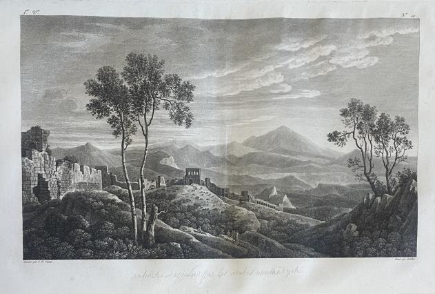
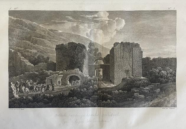
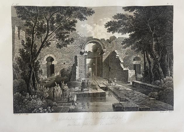
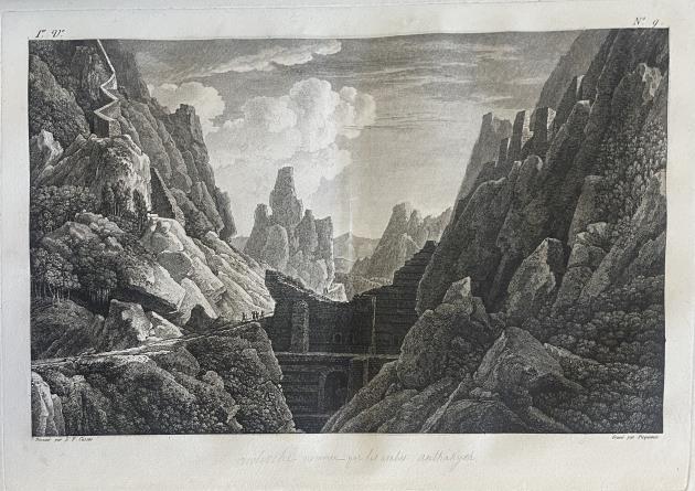
Figure 5 : Four hand-drawn sketches portraying Antioch's appearance during 19th century
Source: Voyage pittoresque de la Syrie, de la Phenice, de la Palestine et de la Basse-Egypte, Cassa, L. (1799) RIBA Library.
Maras, 2023
A magnitude 7.8 earthquake struck Pazarcık, Maras, on 6th February 2023 at 04:17 am In 9 hours, another large quake hit the city with a magnitude of 7.6, followed by 200 aftershocks. (Naddaf, 2023) The tremors ruptured the fault for 300 km along three main segments of EAF called Amanos, Pazarcık and Erkek, extending from Antakya (Antioch) to Adiyaman (Utkucu et al., 2023) This is the largest earthquake in the Turkish Republic’s history. The death toll was more than 54,000, with 130,000 people injured, and 3.2 million displaced. (Armitage and Dexter, 2023)
The population of Maras was 1.1 million, including 750,000 residents who lived close to the city centre, which decreased to 100,000 after the event. (Kıraç, 2023) The data obtained from trenches along the fault showed that the 1114, 1513 and 1872 quakes represented the last events to rupture the fault line. (Utkucu et al., 2023) Utkucu and his colleagues interpreted that these ruptures from the years 1114, 1513, and 1822 (and probably in 115 and 526), contributed to the sheer intensity of the catastrophic earthquake of 2023 Earthquake doublets on the same day are uncommon in Turkey. Previous doublets occurred in 1114 in 16 days, in 1872 in 2 months and in 1999 in 3 months. (Utkucu et al , 2023)
Figure 6 : The 2023 earthquake Source: Nature, Vol.216.
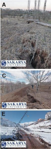
Figure 7 : Surface ruptures of the 2023 Pazarcık earthquake at different parts of the fault rupture. Photos are from (a) Hassa (Amanos Segment), (b) east of Kahramanmaraş (Pazarcık Segment), (c) Balkar, (d) Ozan and (e) Balıkburnu (Erkenek Segment) and north of Narlı (Narlı Segment).
Source: Utkucu et al. 2023
The quake damaged eleven cities: Kahramanmaraş, Antakya (Hatay / Antioch), Adıyaman, Osmaniye, Gaziantep, Şanlıurfa, Malatya, Diyarbakır, Adana, Kilis and Elazığ. The 2,000-year-old ‘handshake’ column in the Karakuş Tumulus in Adıyaman, built in 36-21 BC during the Commagene Kingdom, collapsed as a result The Diyarbakır Walls, built in 349 by the Roman Emperor Constantius II, were damaged. The minaret of the Ulu Mosque in Malatya, built in 1224 during the Anatolian Seljuk Sultan Alaeddin I Keykubad's reign, fell. The castle of Gaziantep, built in the 17th century, was damaged and some walls were fissured. Hacı Yusuf Taş Mosque in Malatya, built in 1912, was seriously damaged by the earthquake, and some of it was destroyed. The Cendere Bridge, built in 211 AD by Lejyon XVI Gallica and the Ancient City of Perre, built in 325 AD during the Commagene Kingdom, weren’t affected.
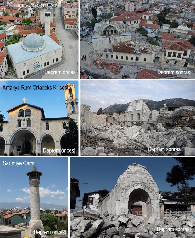
Figure 8 : Photos of Habibi-Neccar Mosque, Antakya Greek Orthodox Church, and Sarımiye Mosque before and after the earthquake.
Source: Uzun and Somuncu, 2023
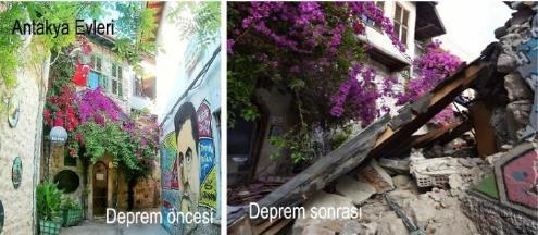
The ancient city of Antakya suffered great destruction. A significant part of the cultural heritage of all periods in Antakya was completely destroyed or severely damaged. Historical buildings on Kurtuluş Street in Antakya were damaged. This street is known as the "first illuminated shopping street at night in the world". Sarımiye Mosque was one of the buildings, its historical minaret was destroyed entirely. The minaret of the Sarı Selim Mosque, built by Mimar Sinan in 1575 and a part of Habib-i Neccar Mosque which was built by Arabs in 638 fell. Buildings that also perished included the Ulu mosque, built in the 16th century by the Mamluks, the Antakya Synagogue, built in 1890, and the Antakya Greek Orthodox Church, built in 1833 The British Protestant School, built in the 19th century and Antakya Turkish Catholic Church, built in 1852, suffered damage Among the unaffected structures were the following: the castle of Antioch, constructed in 300 BC by the founder of the city Seleucus I; the Charonion, made in 22 BC; the Saint Pierre Church, the first cave church of Christianity, built in 5 AD; and The Vespasianus Titus Tunnel, built in 79 AD by the Roman Emperor Vespasian. In addition, the traditional houses of Antakya that have undergone functional transformation have been demolished. A part of the Hatay Archeology Museum was destroyed. 20 containers were delivered to the United Nations’ Ministry of Culture and Tourism in order to protect the precious artefacts. (AA, 2023) (Uzun and Somuncu, 2023)
Figure 9 : Photos of Ulu Mosque and the traditional houses of Antakya before and after the earthquake.
Source: Uzun and Somuncu, 2023
Political Perspective
The south-eastern region of Turkey, especially the surroundings of Maras and Antakya, is known for its seismic location, known by scientists, politicians, citizens, historians, students etc. This collective knowledge has been the case since Roman times (owing to repeated earthquakes of the years 115-526-1114-1513-1872) It should have been no surprise to those in positions of authority that an earthquake was coming. The world-renowned Turkish geophysical engineers warned the government to take precautions, change the regulations, enact new laws for dangerous structures, prevent breaches of building regulations, demolish unsafe infrastructure and construct earthquake-resistant buildings by using up-to-date modern technologies, including high-tech and lowtech building techniques
During the AKP government, zoning amnesty (zoning peace) has been granted 8 times since 2002. The granting of zoning permission by the government, in exchange for money, for buildings that have not been built following the building regulations constitutes zoning amnesty. Licenses can be obtained for businesses and residences in buildings that are granted zoning amnesty. With this process, buildings which haven’t been built according to the rules, and should therefore have been demolished, become legal. (Aposto, 2023) These circumstances and their results occurred during President Recep Tayyip Erdoğan’s Turkey, where breaches of building regulations were commonplace due to bribes paid out to the relevant authorities. Bribery of the survivors has also been increasingly normalized in order to secure votes for their political party, the AKP, who are culpable for this catastrophe. Judging by these actions it is clear that moral and ethical values have been disregarded in exchange for monetary gain The conservative democrats have opted for this devastating scene over that which should have been the case had safe buildings been built in accordance with the law.
“The WSWS interviewed victims in Antakya, Hatay. Volkan, who works as a music teacher, said that their building did not collapse during the earthquake, and that he went outside with his wife and children aged 5 and 7 immediately. However, they could not find a safe, open area: “It was like doomsday outside. There was no open area where we could take shelter. It was cold and raining heavily. Hundreds of people were pushing each other, looking for a place to escape from the buildings that kept shaking with aftershocks. Although it was very risky, I had no choice but to take my car out of the garage on the lower floor of the building where we live. The only way out of the area was by car. Meanwhile, the screams of people trapped under the rubble were mingling with the shouts of people fleeing around the buildings. We took our neighbours who didn’t have cars in my small car. There were eight of us in total. We tried to drive through the street, where buildings continued to collapse due to aftershocks. But traffic was blocked. Some people had heart attacks in front of our eyes. No one could help anyone. We finally reached the garden of the school where I worked, which was also very crowded. There were no toilets. Cars were running because it was cold, so it was very difficult to breathe. But it was the only place nearby with no risk of buildings collapsing on us. One day later, our car’s battery died. Many cars had no fuel. We were waiting for help from the first moments of the earthquake. Fortyeight hours passed, but no help came from anywhere. We were afraid that our children would freeze. On the morning of the third day of the earthquake, we survived because people from other cities voluntarily came to help us.” (WSWS, 2023)
Part 2: Personal experience in Hatay in December 2023
What did I see? What it means?
Having the chance to travel to Antakya in December 2023. The outcome of the 2023 earthquake was observed, analysed and assessed, with the locals' stories being heard first-hand. The state of the destruction in the city was devastating and heart-breaking. It was my first time in Hatay, and having this experience as a future architect made me more ambitious and focused on the use of modern technologies and appreciate the importance of obeying the regulations. The state of the city was incredibly stagnant, calm and quiet. To see the ancient city in the current razed condition, following a long history of thousands of years, with civilisations extending from Sumerians to Hittites, from Persians to Greeks and Romans, from Byzantines to Ottomans, mixed with different cultures, and with a very rich historical heritage, was painfully breath-taking and traumatising. The city was in a noticeable silence, people were quiet, grieving for their loved ones and their home city.
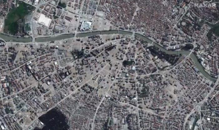
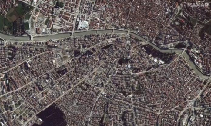
Figure 10 : Photos of before and after, aerial photo of Hatay
Source: Maxar, 2023
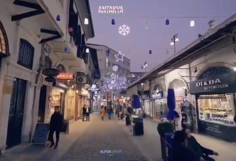
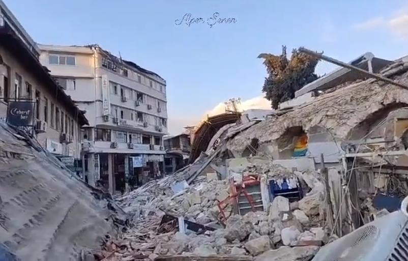
Figure 11 : Photos of before and after, Saray Street in Antakya
Source: Alper Şener, 2023
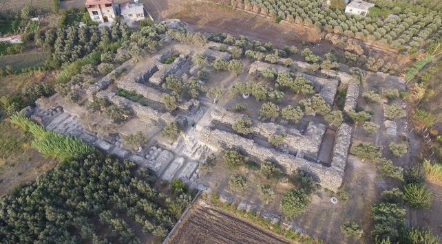
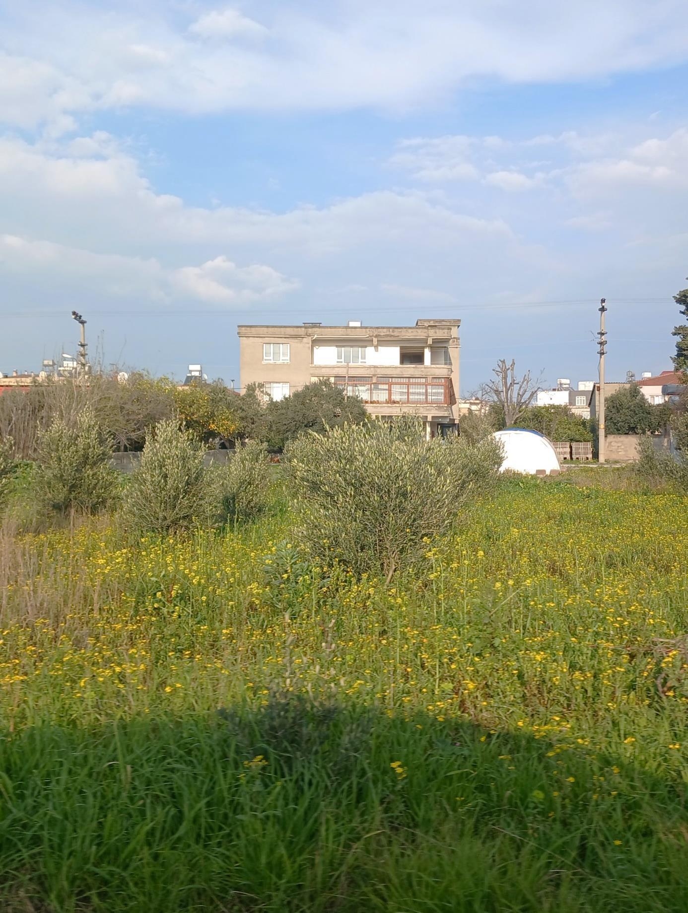
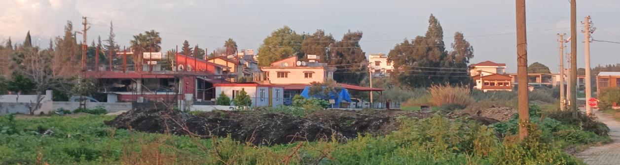
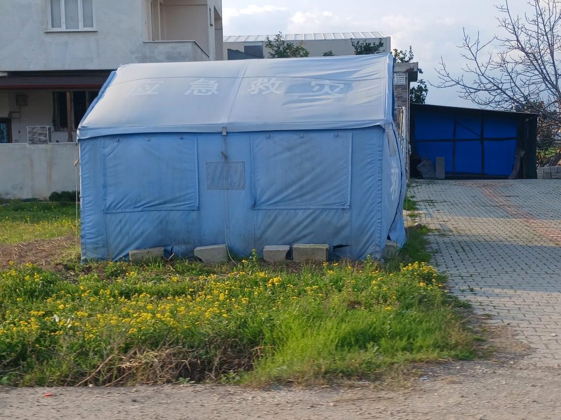
Standing in the middle of a razed city
The view that touched me the most was in the city centre. The feeling was purely shocking, having never experienced a feeling like that before. It was like looking to a blank canvas which was once the most striking and gorgeous painting. There were no buildings left standing, except the big shopping mall with its robust concrete structure; only its cladding was damaged. All debris was removed from the city. The locals mentioned that it was normally impossible to see the mall from the distance from where we were standing; it used to be twenty streets and hundreds of buildings in between but, unfortunately at that moment, us and the mall were the only ones present at that horrific scene.
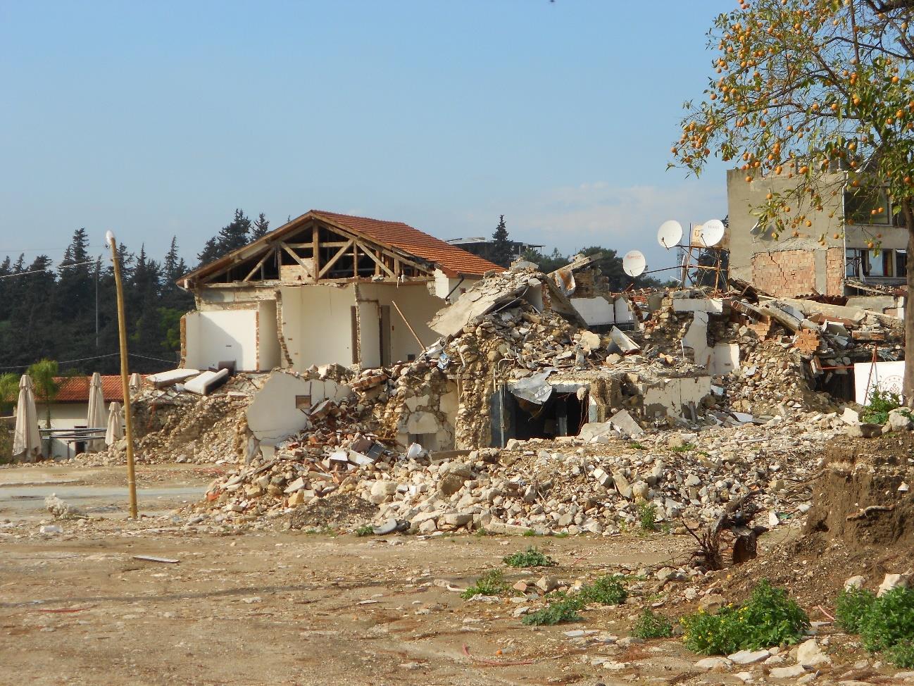
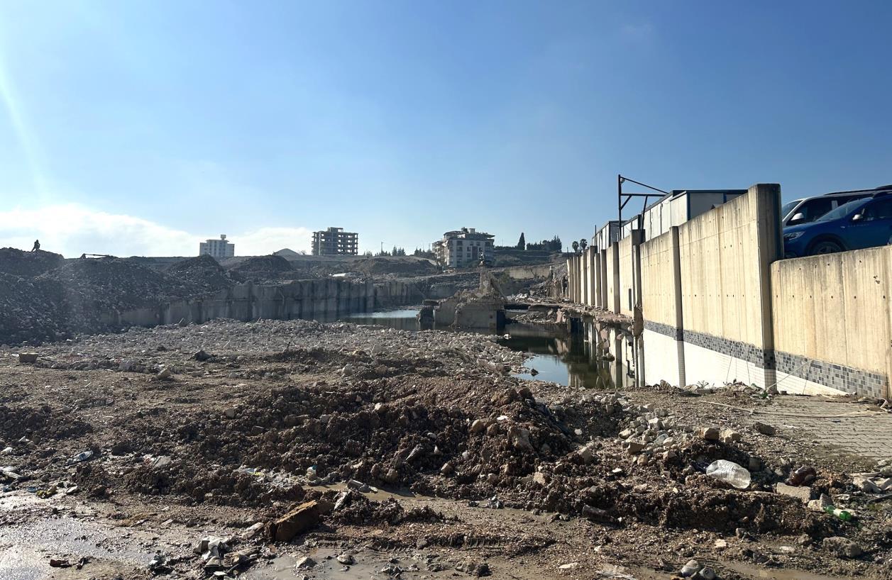
Figure 12 : Hatay city centre around the mall.
Figure 13 : Demolished Hatay city centre
Source: Melis Yürekli, 2023
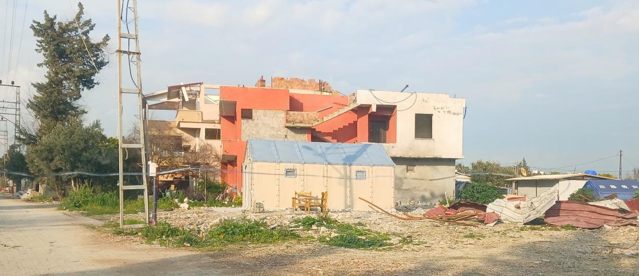
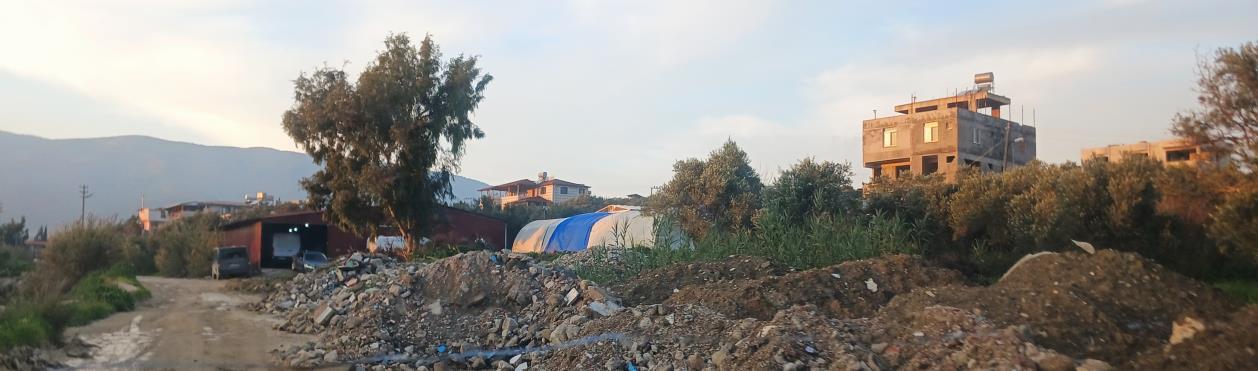
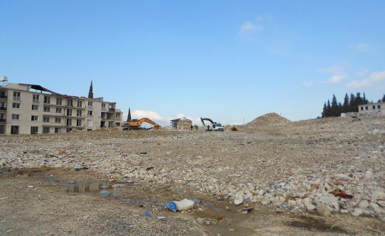
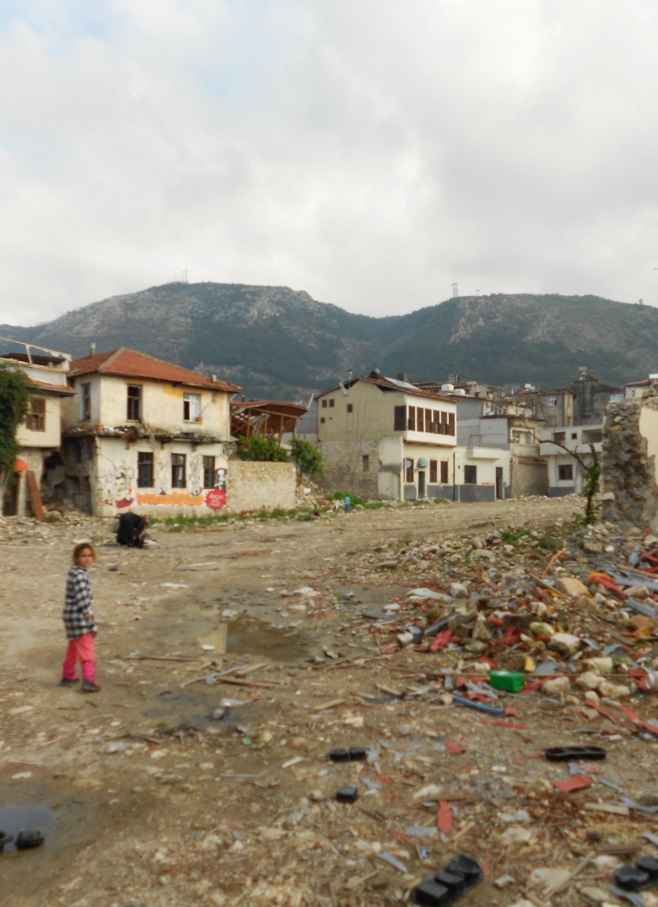
Figure 14 : The ruins in the Ancient City Centre
Figure 15 : A different angle of the ruins located in the heart of the city.
Source: Melis Yürekli, 2023
Making decisions
My research trip to Hatay affected me deeply and intensely. It was a difficult decision whether to go, participate and be a part of the real-time situation. My friends and family asked me if it was necessary and told me there were only so many things I could do. My sister, having experience in psychology, volunteering and helping the children in the earthquake zone supported me and was with me during the whole trip. I realised making a dissertation from 2500 km away wasn’t enough. I wanted to better understand the situation and be there for the people of my country, whose situation and living conditions I’m writing about. I decided to commit to going, well aware of the pain it might cause me. My plan was to go to my home city first, Istanbul, and then continue to Hatay with my sister, Mine. For the two weeks of the Christmas holiday, I got sick for a week in Istanbul and was hospitalised for many days. I was adamant that I wanted to go, so we had to delay our trip twice that week. Later that week, I learned that there was an earthquake in the city during the time I was in hospital in Istanbul and supposed to be in Hatay. My so-called kismet could have stopped me from completing the dissertation due to its well-known effects.
Travelling to Hatay
We arrived in Antakya on 24th December with a correspondence journey from Adana where we took a bus after our flight. The transportation to Hatay was difficult because the direct flights from Istanbul to Hatay are mostly unavailable due to the need to transport vital goods. As mentioned in the first part of the dissertation, Hatay is located in between mountains, an ancient Roman city that was invaded by the Arabs and was ruled by Byzantine, then Ottomans. Mustafa Kemal Ataturk, the founder of the Republic of Turkey assured that the city of Hatay was a part of the Turkish Republic in 1937. His famous words citing the importance of the city is ‘’Hatay is my personal matter.’’ The population of Hatay and Antakya consists of an Arab population of 2.3 million who identify themselves as Turkish as a parent identity. They are as much a part of the country as every Turkish and minority population of Kurdish, Circassian, Bosnian, Albanian, Georgian and Greek, who live together happily.
Figure 16 : Celebrations of Hatay joining the country in 1939
Figure 17 : Mustafa Kemal Atatürk
Source: Unknown
Naked and Bitter Truth
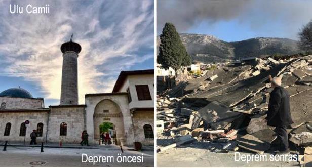
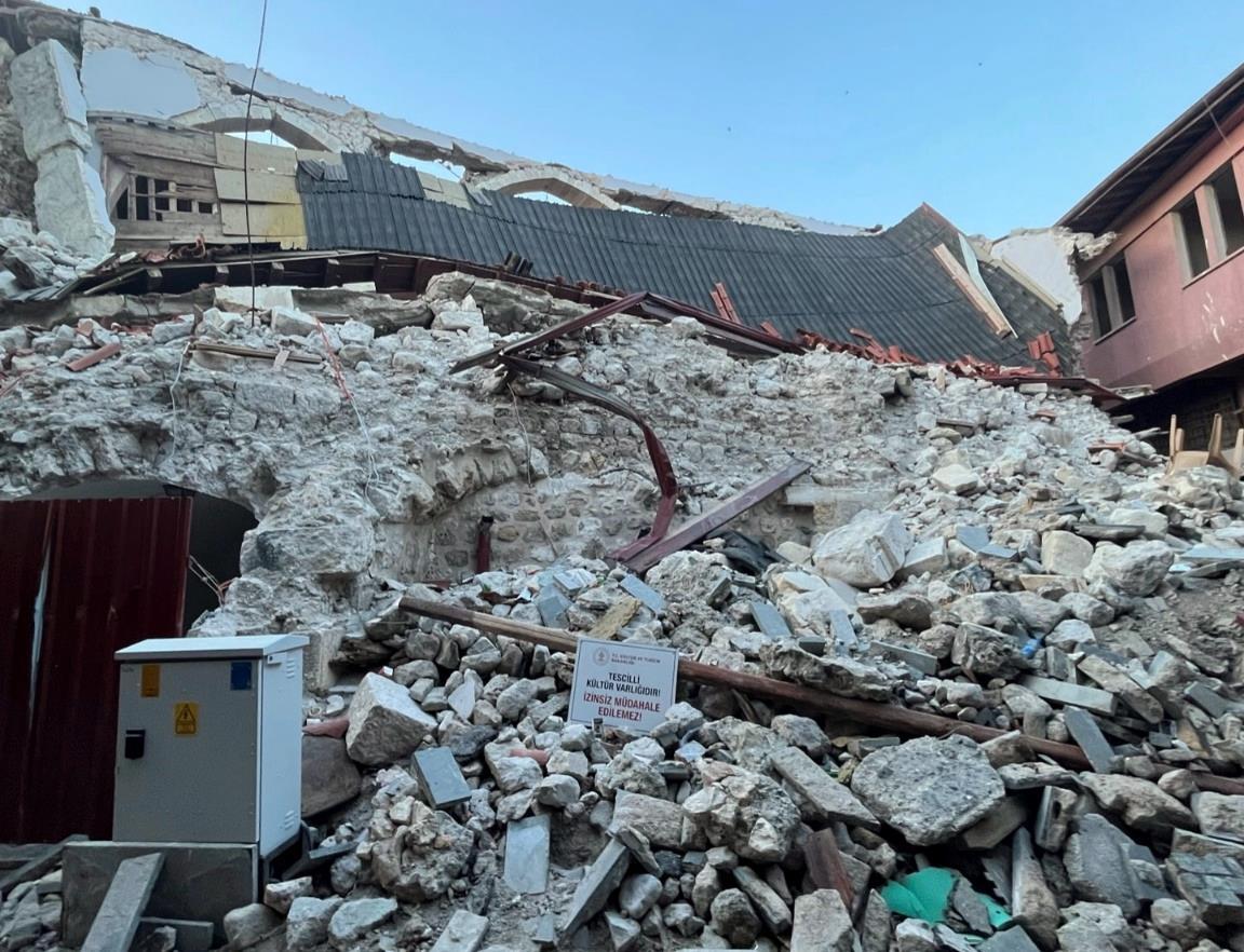
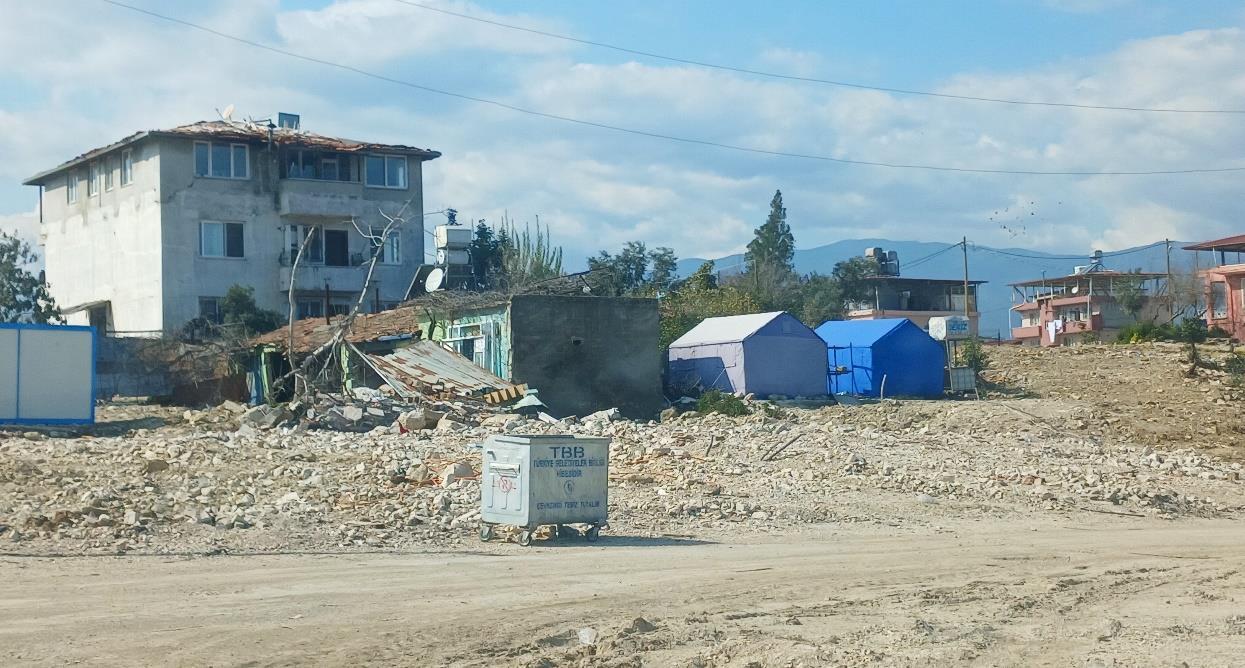
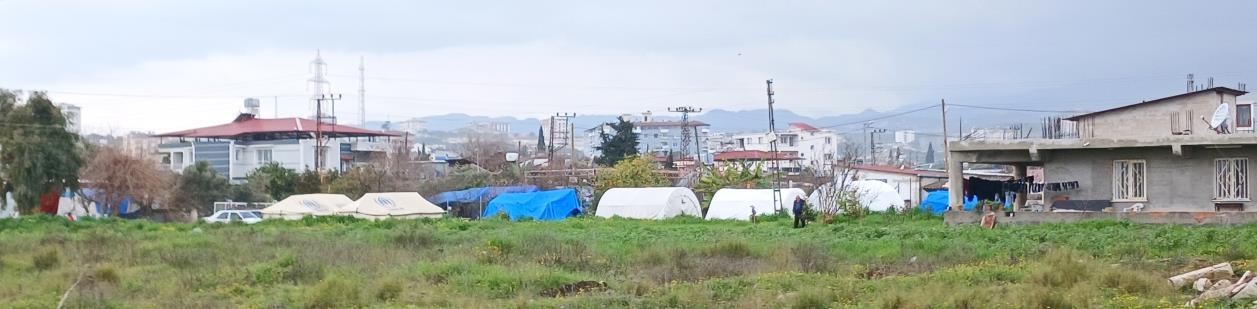
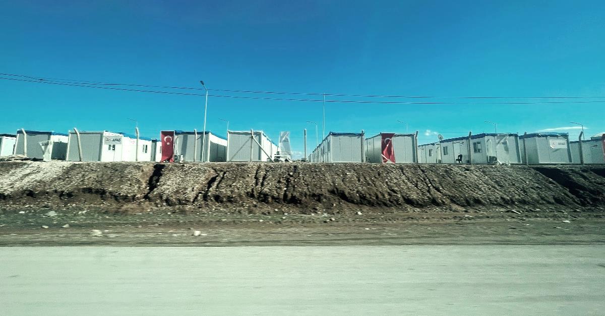
On our first day, we visited many sites researched for the first part of the dissertation. Firstly, we’ve seen multiple tent and container camps, the post-earthquake temporary shelters provided by the government and from outside sources like Korea, Sweden, Azerbaijan, China, Qatar and NATO. The cave on the Amanos Mountain was opened and half of it fell. Uzun Carsi, the main bazaar of the city was in an unrecognisable shape with many old buildings were destroyed. Sarimiye mosque, Habib-I Neccar mosque, Council building, the Antioch Greek orthodox church and the Antioch Catholic Church were damaged intensely. The restorations of these historical monuments have been initiated. The Ulu Camii was completely destroyed and its construction materials were exposed. There was no way to prevent the smuggling of historical construction materials; the Ministry of Culture put a sign that stated, “It is a registered cultural property, it cannot be intervened without permission.” on debris of the historical landmarks.
Witnessing the damaged history
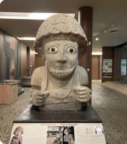
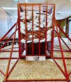
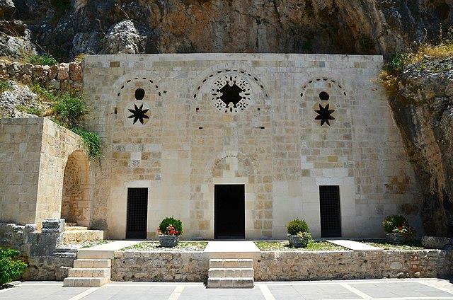
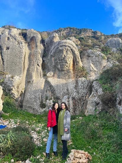
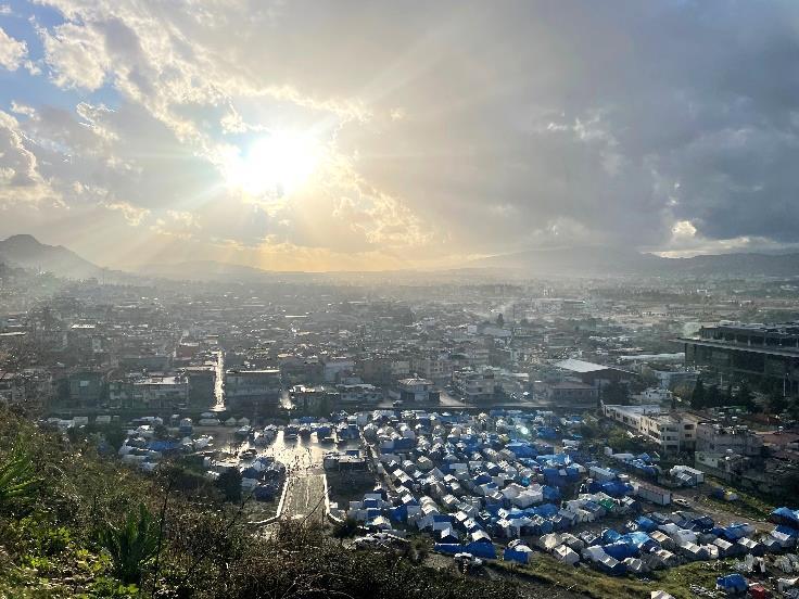
Unfortunately, the trip didn’t include any visit to the remarkable museums in the city as they were all closed due to restoration works. The artefacts in the museums were wrapped in sandbags to be stabilised for the continuing aftershocks. One of the most important artefacts sheltered in the Archaeology Museum is King Šuppiluliuma I’s sculpture. Moreover, it wasn’t possible to access the St. Pierre Church, located on Habib-I Neccar Mountain, which is the first Christian church in history, constructed in 5 AD. After, I had the chance to visit the aqueduct constructed by Trajan in 2nd century which was partly demolished in the 2023 earthquake. Located on the same mountain, the carved stone bust of Charonion (Kharon) was intactly preserved and wasn’t damaged by the earthquake. From the top of the mountain, the lost identity of the city was witnessed, the temporary shelters being the newest neighbourhoods alive.
Figure 18 : Ministry of culture’s sign on the ruins of a historical landmark
Source: Mine Yürekli, 2023
Figure 19 : King Šuppiluliuma I’s sculpture, before and after Source: Turkiye Gazetesi, 2023.
Figure 20 : St. Pierre Church. Source: Melis Yürekli, 2023
Figure 21 : Trajan’s Aqueduct in 2019. Source: Hatay City.
Figure 23 : Carved stone bust of Charonion. Source: Onur Curi, 2023.
Figure 24 : The view from the top of the Habib-I Neccar Mountain.
Source: Melis Yürekli, 2023
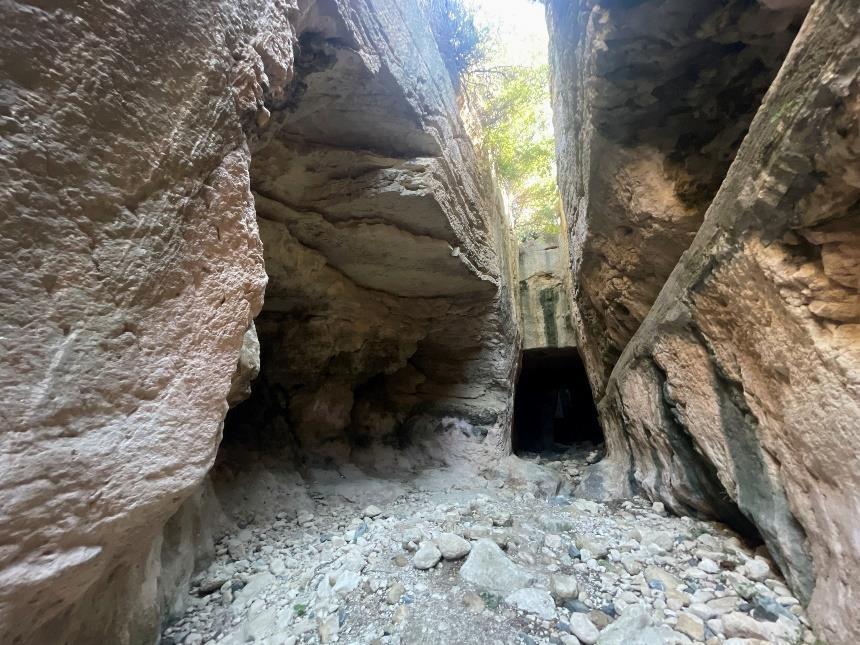
Roman Techniques approved by 2023 earthquake
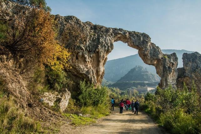
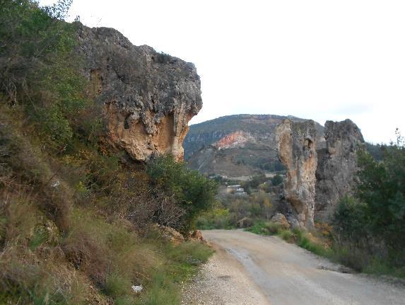
The research led to the Titus Tunnel, constructed by Emperor Vespanianus and later completed by his son Titus in AD 81 was in an untouched state. The massive passage that is 7 metres high, 380 metres long and 6 metres wide, which has been standing for centuries, was still standing incredibly, having outlived many civilisations. The Cradle Craver located on the top of the Tunnel was also perfectly preserved following the earthquake. It was surprising to see that old techniques yield such effective results today. It’s one of the clearest examples of why we are questioning modernity itself and its techniques. How did the 1st-century builders succeed in creating structures that were still standing whilst, in comparison, those of today develop structures so susceptible to damage? This perplexing question will be explored in further parts of the dissertation.
Figure 25 : The Titus Tunnel. Source: Melis Yürekli, 2023
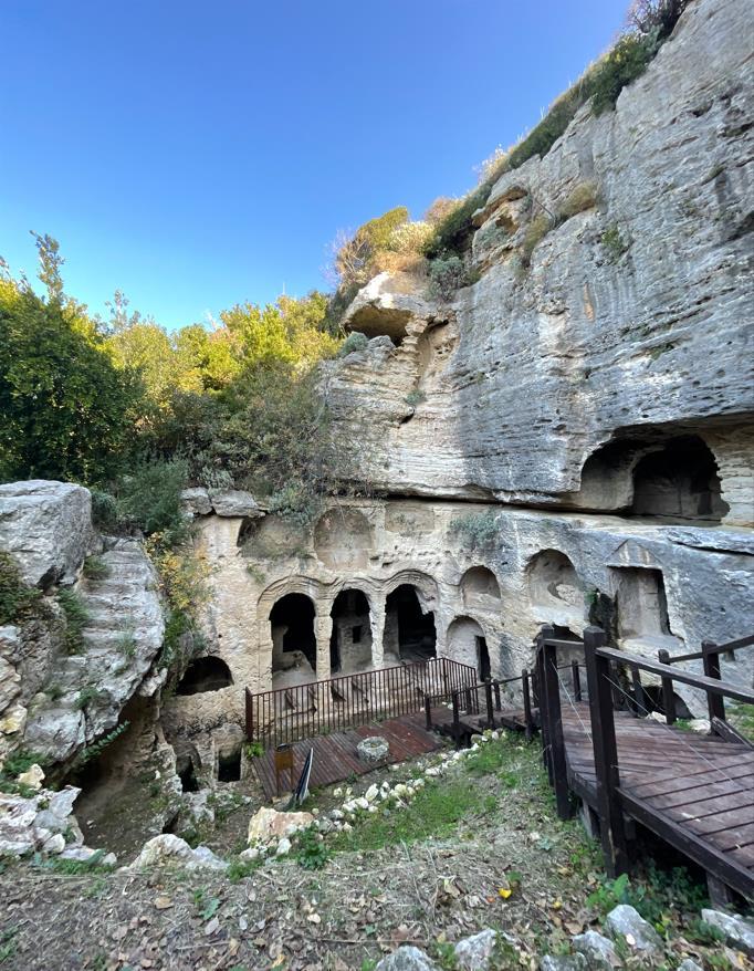
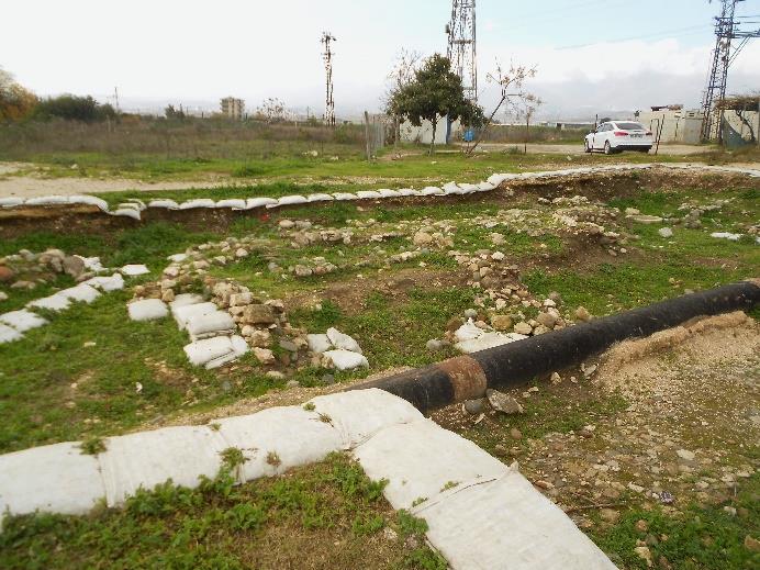
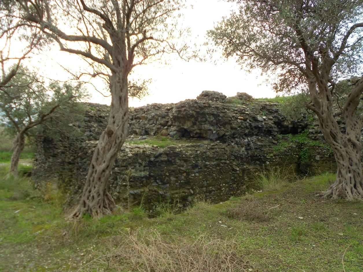
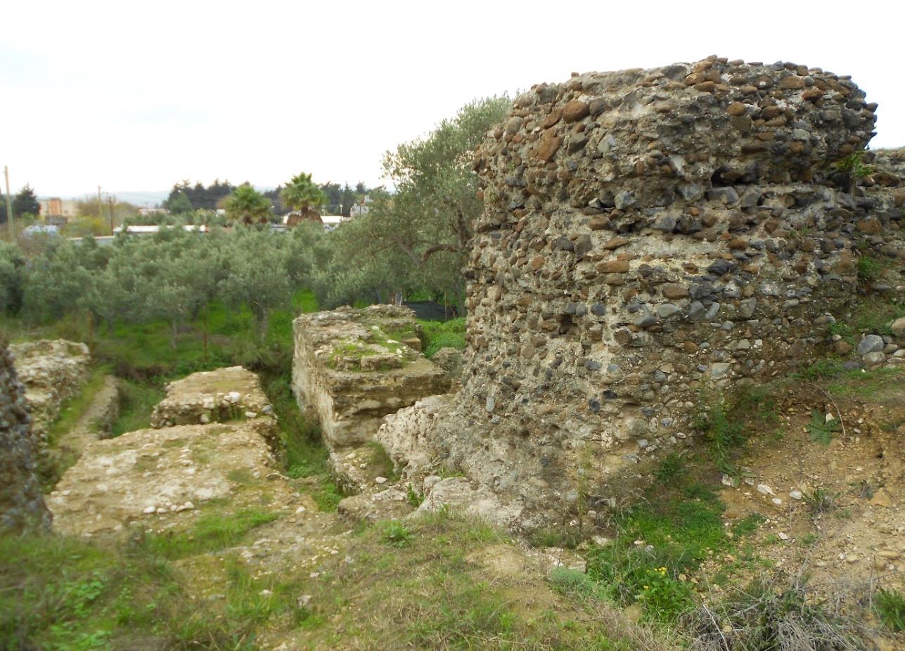
Visiting the vanished island
After the earthquake in 526, the island was destroyed, and the land was abandoned. The fallen imperial palace, hippodrome, church and Roman baths became a source of materials for building the Walls of Justinian. Ruins were observed for this dissertation and were documented on some of the maps produced by Princeton University’s research project team, “The Excavation of Antioch-on-the-Orontes 1932-1939”. There were traces of the demolished imperial palace and the hippodrome whilst, on the contrary, the spina wall, considered the heart of the ancient hippodrome, around which horse chariots raced, was untouched, preserved by many civilisations and having survived several destructive earthquakes. The person responsible for the security of the artefacts mentioned the ongoing archaeological research led by the University of Mustafa Kemal. Witnessing the monuments researched, dating from the 2nd century, fascinated me and gave me hope that the preservation of structures wouldn’t vanish in time if correctly built.
Figure 26 : The Cradle Craver.
Source: Melis Yürekli, 2023
Figure 27 : The ruins of the hippodrome
Source: Carole Raddato, 2022.
Figure 28 : The ruins of the Imperial Palace
Source: Melis Yürekli, 2023
Figure 29 : Another angle of the Imperial Palace’s ruins
Source: Melis Yürekli, 2023
Figure 30 : The ruins of the Imperial Palace from afar.
Source: Melis Yürekli, 2023
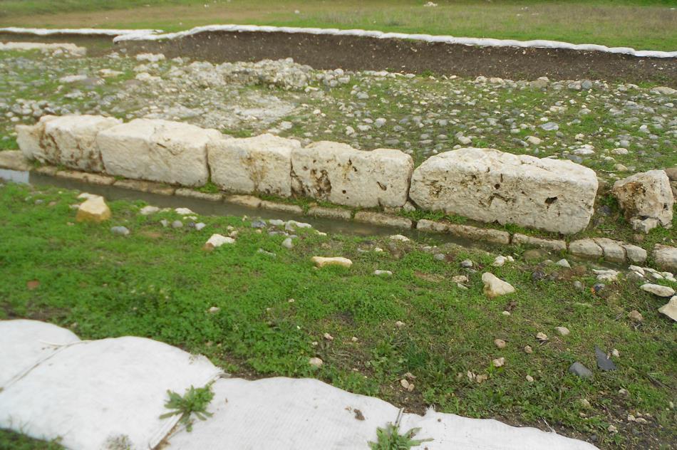
Figure 31 : The aerial photo of the ruins of the spina wall
Source: TRT, 2017.
Figure 32 : The ruins of the spina wall from inside
Source: Melis Yürekli, 2023
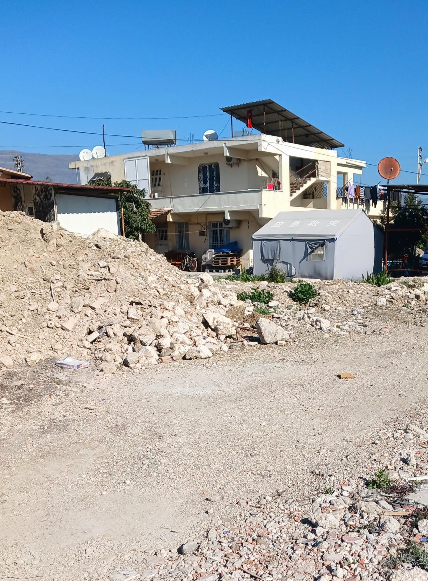
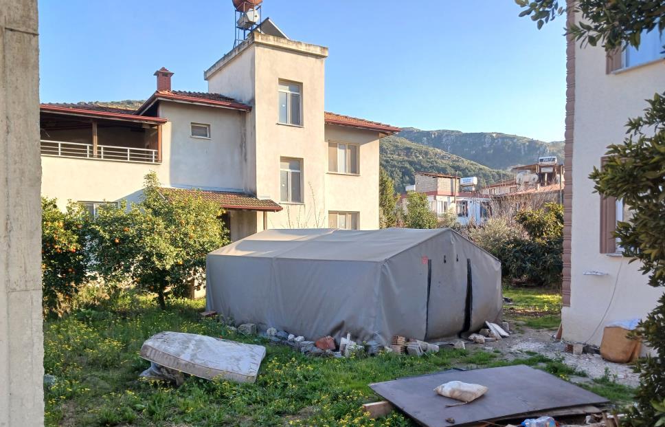
Horror of concrete
The apartment that was proposed to us was on the top floor of a concrete building located outside of the city centre. It was next to the Mustafa Kemal University which made the area quite popular among the young adults, being home to some newly built buildings. Our friend invited us to stay in one of their family tents in a tent camp. He explained also that the concrete building in the new district was approved by the council post-disaster, stating that the structure is currently safe to stay in. We chose to stay in the concrete building, having thought that we didn’t want to encroach upon their newly built homes, having been enough for the local residents only. We spent 3 nights in the apartment and no earthquake happened during that time. During our trip, I observed the common fear of the city’s people, they were no longer trusting concrete, the most used construction material in the world. Regarding the situation, modernity wasn’t a trustworthy option or source of materials anymore.
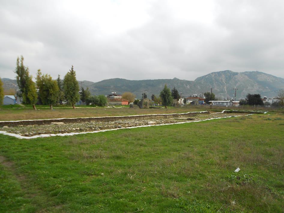
Figure 33 : The ruins of the spina wall with the olive gardens in the background
Source: Melis Yürekli, 2023
Figure 34 : Surviving the aftermath: A series of photographs picturing people living in tents in front of their homes: Photo 1.
Source: Onur Curi, 2024
Figure 35 : Surviving the aftermath: A series of photographs picturing people living in tents in front of their homes: Photo 2
Source: Onur Curi, 2024
Figure 36 : Surviving the aftermath: A series of photographs picturing people living in tents in front of their homes: Photo 3
Source: Onur Curi, 2024
Figure 37 : Surviving the aftermath: A series of photographs picturing people living in tents in front of their homes: Photo 4
Source: Onur Curi, 2024
For us to wake up with hope for a future that awaits.
Figure 38 : Views of the city landscape
Source: Onur Curi, 2024
Life in the village
At one of the houses during the visit, the residents mentioned that they were sleeping in a tent they had built in front of their individual house in the village, whilst for daytime activities they spent the day inside their concretebuilt one-storey house. We spent most of our time in this concrete house, having breakfast, tea, and homemade liquor after meeting their relatives there. The massive earthquake struck the region at 04:17 am and another followed at 01.24 pm. They were anxious about trusting the structures to protect and shelter them safely at night, especially in case an earthquake struck. I started seeing the state of the housing differently, in the villages or in the city. People either left their homes and moved into a temporary camp or wanted to stay next to their houses by having a tent to shelter them at night. Is it appropriate to build the new city in concrete? Are the concrete jungle days already over in the region? Isn’t it the architect's responsibility to respond to this communal fear of the public?
Call for help
The housing crisis became clearer during one of the dinners with Mine and her psychology professor. A kindergarten teacher, who was an old friend of the professor, saw us and joined us after dinner. Like all of the social gatherings we had in the city, this one ended in earthquake-related subjects as well. The teacher was requesting help for her students and Mine explained that their volunteering programme was designed for a different age group of children. The teacher told us about her concerns, explaining that children think that they will return to their old life routines soon and that the people they love will come back again. She explained that when children were asked to take their homework home, they told her, "We don't have a home, teacher." So, the kids weren’t associating the tents and container shelters with home and so were very confused. The teacher, who didn’t know how they could deal with this situation, said that they were at a dead end and called for help from psychologists, saying that every teacher is open and willing to obtain the necessary knowledge.
Needed professions
As four friends at the dinner table with professions of chef, lawyer, architect and psychologist, the locals told us that the professionals they needed in town comprised a team like us. This made me question whether it is wise to leave the earthquake-prone cities post-tragedy. The required help could be provided by the city’s own people, with appropriate levels of additional help from outside. Realising that we would be leaving the city after hearing these facts left us bitter and unpleasant.
Political death toll
Another unexpected truth that came up during the trip was the misleading death toll which was political and a matter of law. Whilst comparing data of the earthquakes with each other, there is a massive difference pertaining to the conditions and laws of today: if a person’s dead body is not found or cannot be identified, he/she is not dead lawfully, which impacts the death toll figures directly. This caused huge problems and lawsuits for broken families. Since the circumstances of the children who lost their parents could not be proven, they didn’t have any recourse for legal guardians to hold their custody.
Many complete families lost their lives in the earthquake. The number of buildings destroyed during the earthquake in Hatay is 12,052. According to the data, the average household size in the province is 3.5 people. (TTV Hatay, 2023) As a result of the calculations made with the number of households present before the earthquake, it is noted that at least 60,000 people lost their lives in Hatay province. (Hasuder, 2023) Since the bodies or traces of many people who lost their lives were not found, the number of deaths announced by the state was 54,000 people in all 10 provinces affected by the earthquake.
An expensive grave to buy
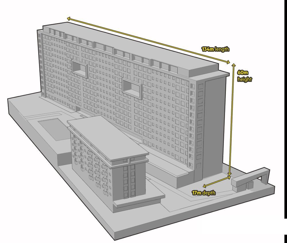
One of the most horrific destructions in the city is the Ronesans Residence located in Ekinci, Antakya. It was the first luxury building in Hatay Province, as well as one of the most prestigious. The residence fell sideways and took 750 lives within 249 apartments. No matter the severity of the earthquake, the newly built buildings should never have collapsed. The building was 134 meters long and 17 meters wide, meaning a length-to-width ratio of approximately 8:1. Due to such conditions, the constructors should have designed the building within the knowledge of civil engineers after conducting an analytical study. The Financial Times made an analysis report about the residence, stating that it was advertised by the slogan “a corner from heaven’’. This collapsed in the earthquake, symbolising the current problems within the construction sector of Turkey.
The building collapsed because of the short column effect and some column stirrups were made at 90 degrees, although they were supposed to be 135 degrees. Dr. Ahmet Ercan, a professor of geophysics, explained that the foundation wasn’t deep enough, and the building fell on the 45th second of the 65-second earthquake. This building is considered a shame in the industry and in the whole country, leaving many people in grief and shock from everything it ruined. All of the contractors, architects and engineers were tried and imprisoned. During the visit, the building’s failed foundation was the only thing that was left of the building. Being at that scene and seeing the destruction was a sickening experience.
Figure 39 : 3D Model of the building with dimensions. Source: Financial Times, 2023
Figure 40 : Drone footage shows the 12-storey apartment building collapsed sideways. Source: Adamaxoi, February 2023
Figure 41 : Ronesans Residence’s Remains, Foundation Source: Melis Yürekli, December 2023
Decision-making after disaster
The temporary shelters provided by the government, and many other countries are only the first stage of solving the housing and sheltering crisis in the area. From my observations and the stories, I heard, the tent and container camps became unsafe and inhumane after some time. Architects should have been involved in this process, creating a safer space for children and animals preventing horrible events. The shock of the earthquake affected many people including adults and children, and living in such dense conditions wasn’t the solution. The wrong decisions post-disaster caused the foundations of newly established settlements to be unstable and caused insecurity and anxiety in society. These plans should have been designed by professionals, including their location, implementation and aspects regarding the common areas. It is not humane to place shocked and traumatised families, individuals, and citizens into sheltering boxes next to each other without any private or semi-communal space.
Figure 42 : Debris in proximity to Ronesans Residence
After the earthquake, there was much aid coming from all over the country and the World. I also helped with the boxing of the goods here in London; several lorries were on their way to Hatay. People sent their own coats, jumpers, and pants in good condition and provided many other pieces of clothing that they needed in the earthquake zone. The earthquake happened on 6th February and it snowed for many days in the area. Many blankets, winter clothes, heaters, baby diapers, torches, sleeping bags, dry food, bags, soap, sanitary pads and many other crucial items were sent. The problem was that there was a problem with the distribution of the goods. The locals couldn’t access them cause the distribution was operated by the government and local authorities. They made several centres for distribution, for couple of days, like an event. It should have been done in every village separately, regarding the condition of the life of the residents. Despite the sincerity of this aid, hundreds of citizens could not benefit from the goods sent to the earthquake zone due to the irregularity of the officials, and the situation turned into an unfavourable one.
Life in Hatay after 11 months
There was traffic in the city, people were rushing to work or to see their families, like every other busy city in the world, despite its state. Nevertheless, the youth found its way to spend time, engage with each other and commiserate over drinks in bars. We experienced some of these social gatherings, all conversations always ended with the stories from the night of the earthquake, getting used to the idea and the feelings. Life moved on and the city was getting ready for regeneration and its renaissance. The city was mostly abandoned with few buildings standing. Students relocated to other cities to carry on their educational lives, some left the city to mourn and work in other Turkish cities, and some stayed in their home city, assist the ones in need and help each other to move on.
Figure 44 : Tents provided by South Korea. Source: Onur Curi, 2024.
Figure 45 : Child roaming around the ruins in city centre
Source: Melis Yürekli, 2023
LOCATION OF HATAY
EXISTING TRACES
DESIGN FRAMEWORK
PLAN SCHEME
GREEN SPACES
TRANSPORTATION LINKS
Conclusion
Long term decisions, next step
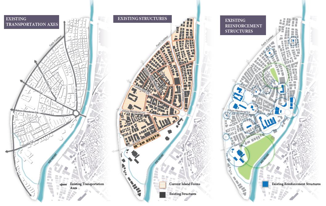
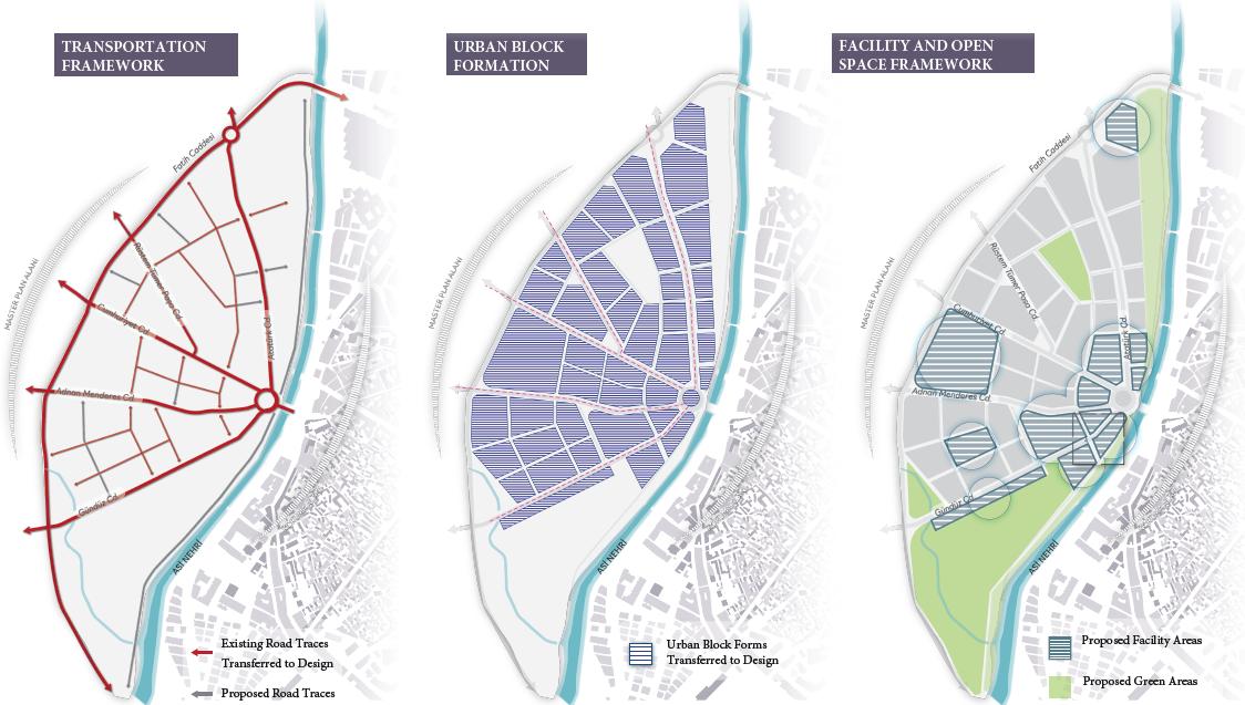
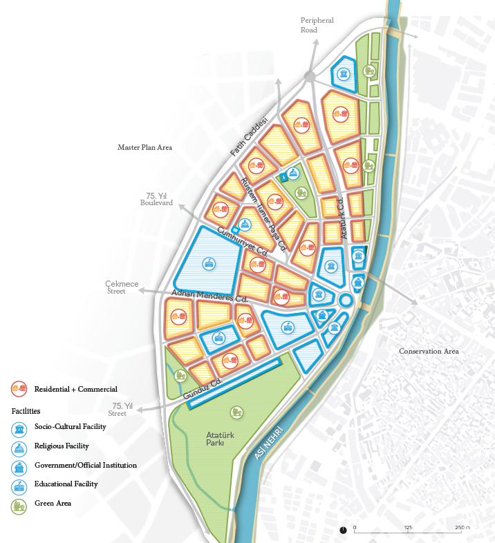
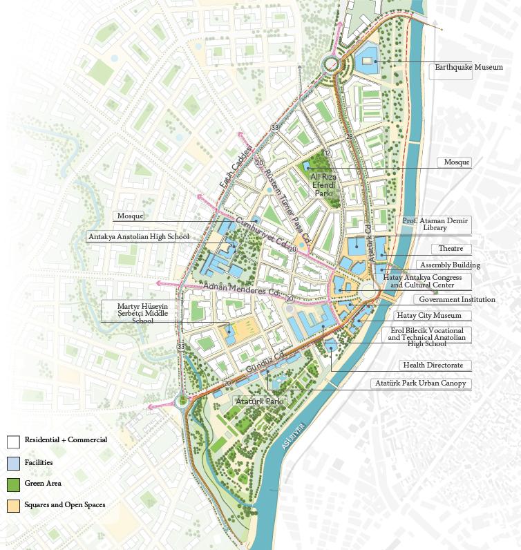
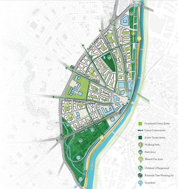
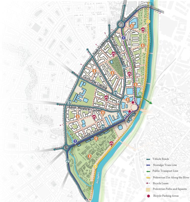
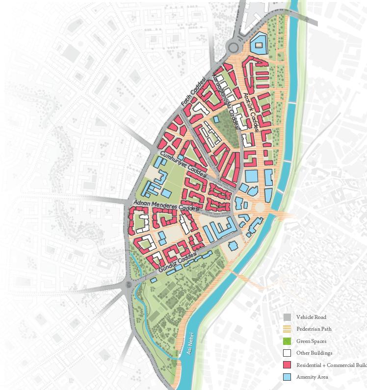
Before the research trip, having had the chance to meet in Istanbul with senior figures from the architecture firms planning the reconstruction of Hatay city centre, the strategies of the proposal were explored. Mr. Ustunbas, who is an architect at DB Architects, showed me their process and the phenomena which were important for the city’s planning. He explained that the focus of their proposal was to redraw the city by its traces, with the main axes of the city by preserving the major gardens and squares. One of the goals of the proposal was to revive the layout to which society was accustomed. Another one was to preserve some of the principles of vernacular architecture in the area by introducing housing with courtyards. Hatay’s people spend time in these courtyards and invite their neighbours and friends for drinks and food; it’s additionally a place where children can play safely. They also plan the entrances of the houses with stairs in front of the door as a space for the locals and neighbours to drink tea while conversing. Recreating the city through its traditions and old habits is an emotional, delicate and respectful job for architects, which revives and stimulates both people's and the nation’s memory.
Challenge is the structure
After having conversations knowing the project’s strategies, the preferred construction materials were discussed. The architect approved that every material could be used in the earthquake zone if used in the right way with the appropriate techniques. Using a great deal of modern structural knowledge as well as certain elements could help the building resonate. Therefore, concrete, steel, wood, stone and others could be used alongside modern techniques.
Great Fire of London in 1666 and Warsaw at the end of WW2
The reconstruction of the cities happened before and will be a part of history again. After the Great Fire of London in 1666, where the quarter of the city was destroyed, various individuals, including Christopher Wren, John Evelyn, Robert Hooke, Richard Newcourt and Valentine Knight, proposed masterplans for the reconstruction of the city. (Science Museum, 2019) While Sir Christopher Wren’s proposal included grand boulevards and large civic spaces with a Baroque touch like Paris, others were imagining a more rational city with a uniform grid that had a dense number of church bells, towers and squares. All of the proposals were different from others in a unique way. London was rebuilt by the Rebuilding Commission. It had six members: three appointed by the King, like Christopher Wren, and three from the City, like Robert Hooke. They were all experts in surveying, building, or designing buildings. It took approximately 50 years to rebuild London after the Great Fire, and its effect can still be seen today, like the irregular layout of streets and the presence of church ruins throughout the city. (Forest, 2016)
Moreover, after WW2, 85% of Warsaw’s historic centre was destroyed by Nazi troops. After the war, reconstruction took six years to complete, resulting in today’s Old Town. (UNESCO) The paintings of Bernardo Bellotto (1722-1780) were used to rebuild the historic city centre from its ruins which now form a UNESCO World Heritage Site. (The Guardian, 2016) The reconstruction was funded by the donations made by the country’s people. (Glinski, 2015)
Source: Melis Yürekli, 2024
Architects design the city for the comfort of the residents, for their needs and wishes, equipped with public and private spaces. In this specific scenario, the role of the architects and their relationship with other parties; the funder, the government and the people are unique, and all parties have different wishes and purposes. The projects that constitute the reconstruction of Hatay are funded by the World Bank. The damage in 10 cities is worth 32 billion US dollars. The World Bank’s unconditional funding for the earthquake zone is 1.78 billion US dollars. (World Bank, 2023)
These parties, which play a role in the design of the city's renewal, cause dilemmas in the decision stages. As previously mentioned, the project proposal was furnished to preserve the habits and perceptions of Hatay's people. Architects have designed it so that society will be comfortable, can rebuild its homes and hold on to life in the city with the same cultural and social principles as before. However, even though this is a project prepared by architects with their responsibilities towards society, in this case, the state and the World Bank, which covers the projects, retain decision-making powers. The state supports the high number of floors built and the high density in the city, which does not comply with the proposed principles inspired by the character of the city. The question is, who is the client? For whose realm are the architects designing?
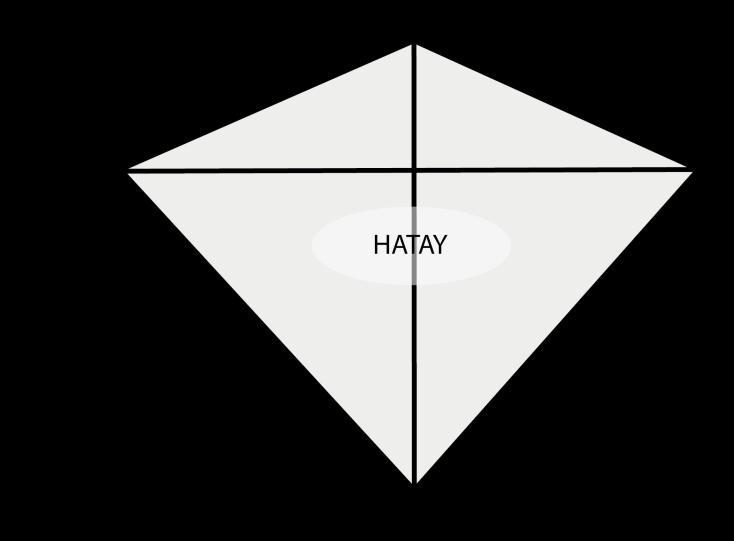
In the 2023 Earthquake in south-eastern Turkey, tectonics plates, nature, the public, architects, local authorities, the president, and local politicians as individuals formed human and non-human actors who acted over time in a world where they interacted and were all connected in a network. After the main event, which was the earthquake in this scenario, all of these relationships shifted, responding to the situation where everyone became affected. Latour’s actor and network theory enables the audience to better understand the relations in this chaotic, volatile time.
The responsibility of architects is to reconstruct the destroyed city in a way that is suitable for today and the future without damaging the character of the area. Examples of this have been seen in the past as well. Politics affects the country's rules and methods, but it should never affect business ethics. In my opinion, in this case, the architects’ client is the society that lost its cities, and, in fact, the client is the ancient city of Antioch, a city that cannot be overlooked.
After having these experiences, it becomes clear how modernity has failed and cannot meet people’s needs. Latour additionally criticises the distinction between nature and society and describes the idea of “modernity” as a separate era in human history as a false construct in his book We Have Never Been Modern (1991). (Parliament of Things) He supports the idea that the modern world is based on an assumption that there is a
Figure 46 : Diamond of relations
clear separation between nature and society and between science and politics. This separation doesn’t actually exist, however, and these concepts are entangled. His argument is that the modern world is just an illusion and that nature cannot be controlled or mastered through science and technology. (Latour, 1991) I agree with his theory to a certain extent. Certainly, nature cannot be under the control of the “modern world”, but contrarily, with modern technologies, society can learn how to live with it rather than change its behaviour. In this case, the 500-year cycle of earthquakes in south-eastern Turkey cannot be prevented or avoided. For today’s “modern world” and the future, it is necessary to comprehend and apply modern technologies and opportunities with all their power, add existing geographical conditions into the equation and learn to live with them in the most comfortable and safe way. Architects planning the reconstruction of the city confirmed all construction materials were suitable for the earthquake-prone region and that the appropriate use of modern techniques will enable the society to continue living in the city and pass on the history, culture and values to future generations.
Thus, I believe that the failed modernity in the region is a result of the failed politics in the country and its corrupted regulations and inspections. This can be exemplified by Erdogan’s recent speech for the upcoming local elections, where he said, “If the government and the local authorities do not join hands and are not in solidarity, nothing will come to that city.” (referring to rescue teams, help, reconstruction). "Is there any damage to Hatay?" he said. (BBC Turkey, 2024) We all know the answer to that.
During this research, the destructive earthquakes experienced by an ancient city from the 2nd century to the 21st century and how the city was affected in terms of architecture were observed. Equipped with this information, I witnessed history repeating itself during my trip. I analysed a destroyed city first-hand, visited the affected structures, and made observations while spending time with the community. Research was made on the steps taken to recreate the city. I had the chance to meet the pioneer architects of the proposed project and the president of the Hatay Chamber of Architects. As a future architect, after gathering extensive information about an ancient city, I enjoyed contributing to the reconstruction of the city for the good of the society and the country. It was an honour to see with my own eyes society in today’s Turkey that persists in its cause and does not abandon its people in their time of need, in spite of oft-challenging conditions.
After looking into this cruel truth of “modern” Turkey - visiting, seeing, and having an ‘’excellent’’ experience first-hand as an architect with the most devastating scenes - it is essential to understand that the architects who operate in a failed political scene are still responsible for their people and the culture of the region. The role of an architect is to navigate the politics for the realm of the public and, therefore, the country. While understanding the problem is the first necessary step of disaster recovery, it is vitally important for architects to act for the good of society and the city, regardless of one’s political affiliations
To conclude, as a Turkish architect, I am aware of the value within my country. Completing this dissertation provided me with the opportunity to analyse the situation fairly and illuminate the problem, its solution and methodology. As someone with an international background, I see that this event has an important place in my career life. After the earthquake, I knew there wasn’t any other subject I was interested in researching and writing about. Like the founder of the Turkish Republic said, ‘’The one who loves his/her country the most is the one who does his/her duty best’’, after finishing this dissertation, I, as an architect educated in different countries overseas and a citizen of Turkey, strongly believe that I am fulfilling my duties by professionally critiquing the current situation with optimism for a better future. My wish is to prioritise work and social ethics, participating in projects that can bring good to society and create a safe environment for future generations.
Bibliography
Palutoğlu, M. and Şaşmaz A. (2017) 29 November 1795 Kahramanmaraş Earthquake, Southern Turkey. Bulletin of the Mineral Research and Exploration. May 2017. Retrieved from: DOI: 10.19111/bulletinofmre.314211 (Accessed: 17 November 2023).
Eyidoğan, H. and Güçlü U. (1993) Jeofizik 7, 95-108 Türkiye Deprem Bölgeleri Hariatsının Evrimi ve Yeni Bir Harita İçin Öneri (in Turkish) [‘Geophysics 7, 95-108 Evolution of Türkiye's Earthquake Zones Map and a Proposal for a New Map’]. Jeofizik Dergisi 7, No.2 December 1993. Istanbul.
Utkucu, M., Uzunca, F., Durmuş, H., Nalbantı, S., Sert, S. (2023) The 2023 Pazarcık and Elbistan Kahramanmaraş Earthquakes in the Southeast Türkiye. Sakarya University Disaster Management Application and Research Center and Department Geophysics. Sakarya.
Altındal, A., Konak, N (2002) 17 Ağustos 1999 Depreminde Yıkılan Binaların Mimari Hataları (in Turkish) [‘Architectural faults of the buildings collapsed in the earthquake of 17 August 1999’]. Sakarya University Journal of Science, 6. p.2. Retrieved from: doi: 10.16984/saufbed.86914. (Accessed: 18 November 2023).
Bakır, N. (2023) Deprem vergisi'nde 23 yıllık tahsilat 88 milyar TL (in Turkish) [‘23-year collection of 'earthquake tax' is 88 billion TL’]. Dünya 9 February 2023. Retrieved from: dunya.com/kose-yazisi/deprem-vergisinde-23yillik-tahsilat-88-milyar- (Accessed: 18 November 2023).
AFAD. (2023) Türkiye Deprem Tehlike Haritası (in Turkish) [‘Türkiye Earthquake Hazard Map’]. Retrieved from: afad.gov.tr/turkiye-deprem-tehlike-haritasi (Accessed: 2 Decemeber 2023).
Raddato, C. (2016) The 115 Earthquake in Antioch. World History. May 2016.
Azarak, L.U. (2023) Tarihin İzdüşümünde Antakya (Antiokheia) Kentinin Depremselliği (in Turkish) [‘Seismicity of the City of Antakya (Antiokheia) in the Projection of History’]. Vakanüvis-Uluslararası Tarih Araştırmaları Dergisi, Vol.8
Cassius, D. (235) Dio’s Roman History. Edited by Cocceianus, C.D. and Cary, E. (1925) Roman History by Cassius Dio, Vol: 8. Heinemann.
Meghraoui, M., Gomez, F., Sbeinati, R., Van der Woerd, J., Mounty, M., Darkal, A. N., Radwan, Y., Layyous, I., AlNajjar, H., Darawcheh, R., Hijazi, F., Al-Ghazzi, R., and Barazangi, M. (2003) Evidence for 830 years of seismic quiescence from paleoseismology, archaeoseismology, and historical seismicity along the Dead Sea Fault in Syria, Earth Planet. Science Direct.
Reinhardt, E.G.; Goodman B.N.; Boyce J.I.; Lopez G.; van Hengstum P.; Rinnk W.J.; Mart Y. & Raban A. (2006) The tsunami of 13 December A.D. 115 and the destruction of Herod the Great's harbour at Caesarea Maritima, Israel. Geological Society of America. Retrieved from: doi:10.1130/G22780A.1. (Accessed: 19 November 2023).
Boatwright, M.T. (2003) Hadrian and the Cities of the Roman Empire. Princeton University Press. P.138. Retrieved from: ISBN 978-0-691-09493-9 (Accessed: 21 November 2023).
Dirven, L. (1999) The Palmyrenes of Dura-Europos: A Study of Religious Interaction in Roman Syria. Religions in the Graeco-Roman World. Vol. 138. p.112. Retrieved from: ISBN 978-90-04-11589-7. (Accessed: 21 November 2023).
Rickett, O. (2023) 'Thunderbolts and terror': How historic earthquakes destroyed Roman Antioch. Middle East Eye. February 2023. Retrieved from: middleeasteye.net/discover/turkey-syria-antioch-historic-earthquakethunderbolts-terror (Accessed: 22 November 2023).
Wikimilli (2023) 115 Antioch Earthquake 27 December 2023 Retrieved from: wikimili.com/en/115_Antioch_earthquake (Accessed: 22 November 2023).
Theophanes Confessor. (813) Chronicles. Edited by C. Mango and R. Scott (1997) The Chronicle of Theophanes Confessor: Byzantine and Near Eastern History. Clarendon Press. Oxford.
John of Ephesus. Ecclesiastical History, Part III, Book I. Edited by J.P.N. Land (1868) Ecclesiastical History, Fragments of Part II. Leiden.
Guidoboni, E., Comastri, A. and Traina, G. (1994) Catalogue of Ancient Earthquakes in the Mediterranean Area up to the 10th Century. Bologna.
Malalas, J. (578) Chronicles. Edited by E. Jeffreys. (1986) ‘BOOK 17 - The time of the Emperor Justin’, in The Chronicle of John Malalas: A translation. Melbourne: Australian Association for Byzantine Studies, pp. 281–285.
Runciman, S. (1951) The History of the Crusades. Volume I: The First Crusade and the Foundation of the Kingdom of Jerusalem.
N. Ambraseys, N. (2004) ‘The 12th-century seismic paroxysm in the Middle East: a historical perspective’, in ANNALS OF GEOPHYSICS, Vol. 47. London. Department of Civil Engineering, Imperial College, pp. 738–741. Retrieved from: doi.org/10.4401/ag-3303 [Accessed 1 December 2023].
Reda Sbeinati, M., Darawcheh, R. and Mouty, M. (2005) ‘The historical earthquakes of Syria: an analysis of large and moderate earthquakes from 1365 B.C. to 1900 A.D.’, in ANNALS OF GEOPHYSICS, Vol. 48. Damascus. Department of Geology, Atomic Energy Commission of Syria and Department of Geology, Faculty of Science, Damascus University.
Casta, S. (2017) Natural Disasters and the Crusades: Framing Earthquakes in Historical Narratives, 1095-1170. University of Waterloo, Ontario.
Fulcher, C. (1127) A history of the expedition to Jerusalem. Edited by Recueil des Historiens des Croisades. (1866) Vol. 3. Paris.
Kesik, M. (2012) ‘Maras Depremi’ (in Turkish) [‘Maras Earthquake']. Tarih Dergisi. Vol. 42.
Bongars, J. (1611) The Deeds of God Through the Franks or the History of the Eastern Expeditions and the Kingdom of the Franks in Jerusalem. Vol. 1.
Sigebert de Gembloux. Chronicles. Edited by G.H. Pertz (1844) Monumenta Germaniae Historica, Scriptures. Vol. 6. Hannover.
Walter the Chancellor. (1115) The Antiochene Wars. Edited by S.B. Edgington (1999) Walter the Chancellor’s The Antiochene Wars.
William of Tyre. (1115) ‘L’Estoire de Eracles empereur et la conqueste de la terre d’Outreme’ (in French) [‘The Estoire of Eracles emperor and the conquest of the land of Outreme’]. Edited by Receuil des Croissades. (1844) Vol. 1. Paris.
N. N. Ambraseys, Temporary seismic quiescence: SE Turkey, Geophysical Journal International, Vol. 96, Issue 2, February 1989, Pages 311–331
Mut, G. (2023) ‘Aynı fayın, aynı segmenti kırılmıştı: 1114 ve 1513’te Maraş Pazarcık’ta neler olmuştu?’ (in Turkish) [‘The same segment of the same fault was broken: What happened in Maraş Pazarcık in 1114 and 1513?']. Hürriyet, February 2023.
National Geophysical Data Center and World Data Service. (1972) Global Significant Earthquake Database "Significant Earthquake Information". NOAA National Centers for Environmental Information.
Sieberg, A. (1932) Untersuchungen ubar erdbeben und bruchscholenbau im Ostlichen mittelmeergebiet, Denkschrifften der Medizinsch-Naturwissenschaft Gesellschaftzu. (in German) [‘Studies on earthquakes and