Job Application Spring. 2023 Portfolio | Xi Sun
1
Decarbonization Strategy Dev. | Fall 2022
Instructors: Prof. Aglaee Degros & Stephan Bendiks
2
From Waste to Green
Sustainable Strategy Dev. | Fall 2020
Instructor: Prof. Daniel Choi
Tube City
Decarb Lux 3 4
Urban Design Studio | Senior, Fall 2019
Instructor: Prof. Jennifer Birkland
Uzima: Spaces of Nourishment & Healing
Independent Design Research | Summer 2019
Supervisor: Prof. Stacey Langwick
In Workshop by Visiting Lecturer Michael Blier, Spring 19’
Prof. Aglaee Degros Prof. Stefan Bendiks
Decarb Lux

INDIVIDUAL PROJECT SITE

Esch-sur-Alzette, Luxembourg
DecarbonizeLuxembourg’sconstructionsectorthroughamaterialcirculationsystem
As one of the richest countries in the world, Luxembourg has the highest per capita carbon emissions in Europe. In 2020, the Luxembourg government announced its National Energy and Climate Plan (NECP) and aimed for a 55% decrease in its greenhouse gas emissions by 2030, and for climate neutrality by 2050. Its ambitious targets require a significant shift in all sectors and call for immediate action. Themed around “territorial transition”, our Fall 2022 studio explored the more agile forms of planning and design as a replacement for linear master planning. Structured around five notions — Territory, Platform, Transition, Scale(s), and Uncertainty, the studio made us think of spatial consequences across scales and agencies.
Problems & Solutions
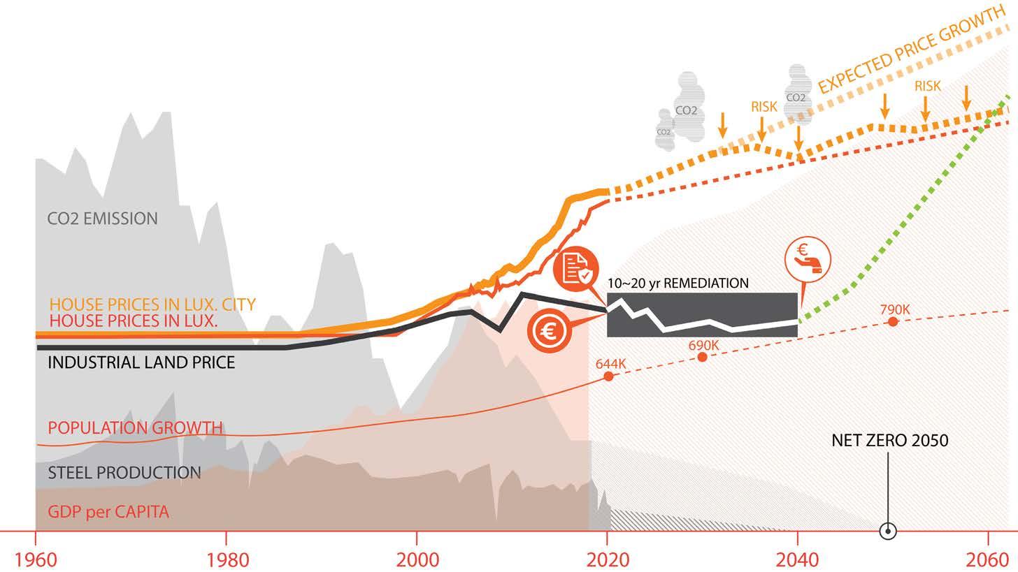
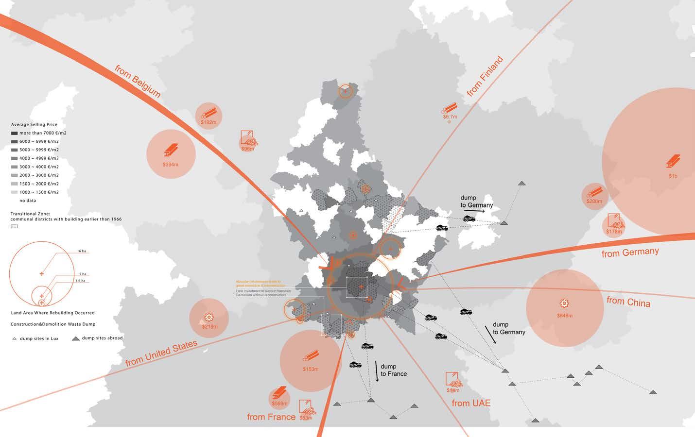
Among the broad themes, I target the decarbonization of the construction sector. I start by identifying 3 main problems of the sector: 1. Reliance on imports 2. high construction & demolition waste volume 3. shortage of landfill space. The problems are a result of the fast construction & demolition turnover. In Luxembourg City where housing price is rocketing, investors tend to demolish and rebuild due to fierce competition for land. However, just 20 km away from the city, the situation is completely opposite. Due to a lack of investment, most of the post-industrial land on Luxembourg’s southern border is vacant and deserted. The obsoleting factories need productive programs to sustain their brownfield remediation and future redevelopment. What about reusing the old buildings for a construction materials recycling hub?
Share of Emissions by Sectors
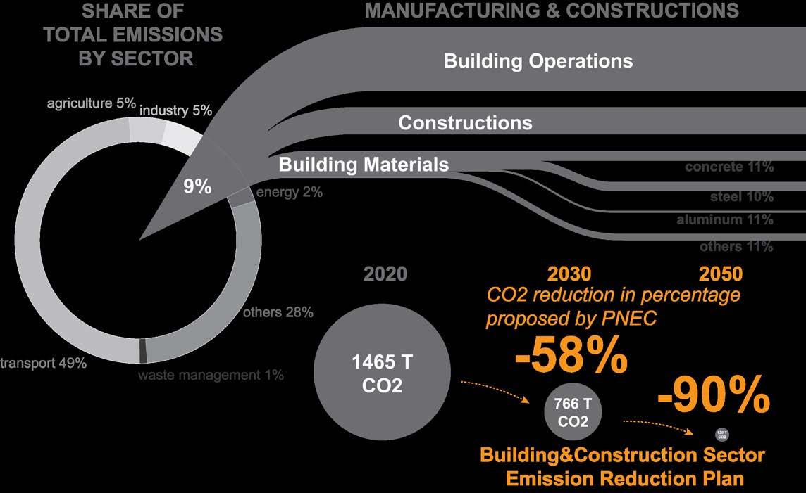
The Building & Construction sector is the second most emissive sector. The Luxembourg government has set an ambitious goal to reduce the emission of this sector by over 50% in less than 10 years from now.
Mapping out Current Problems
Luxembourg’s Building & Construction sector has 3 main problems: 1. Reliance on imports 2. high construction & demolition waste volume 3. shortage of landfill space. As shown in the map above, the prosperity of Luxembourg City depends on the support of its neighbors.
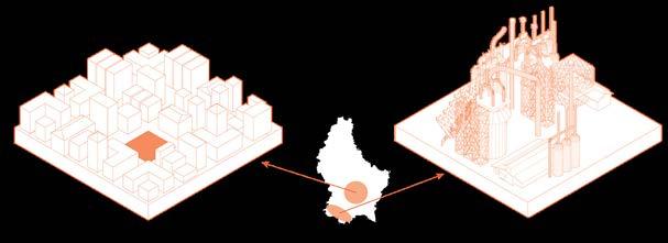

Price Differences Drive Imbalanced Investments
Investors can expect good returns on investing in the city thanks to Luxembourg’s strong economy & population growth. However, it’s hard for them to expect an even better return from a revitalized brownfield project due to the long remediation progress.
Strategy
2022
ACADEMIC Decarbonization
Fall
INSTRUCTOR
1
Transition Principles
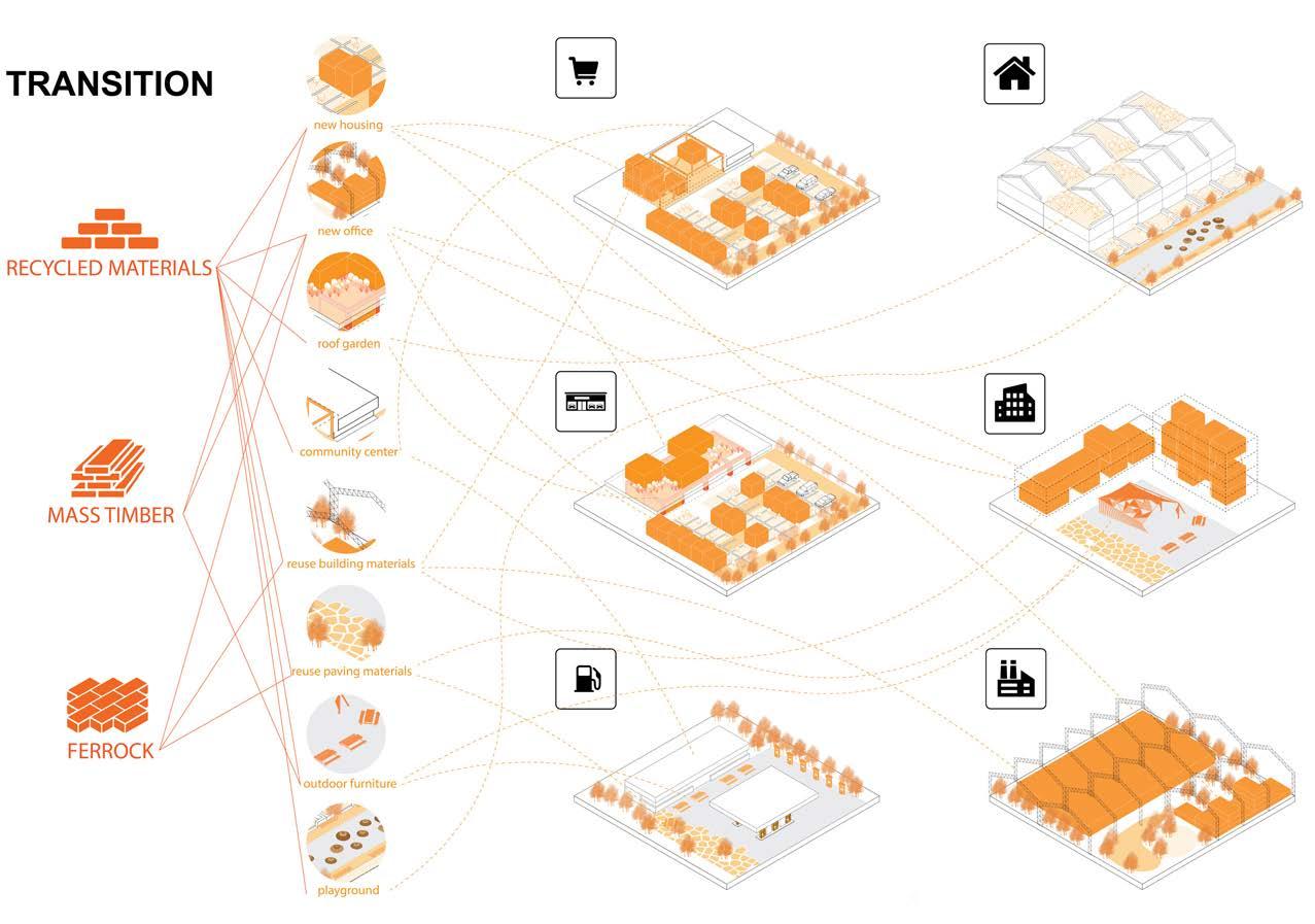
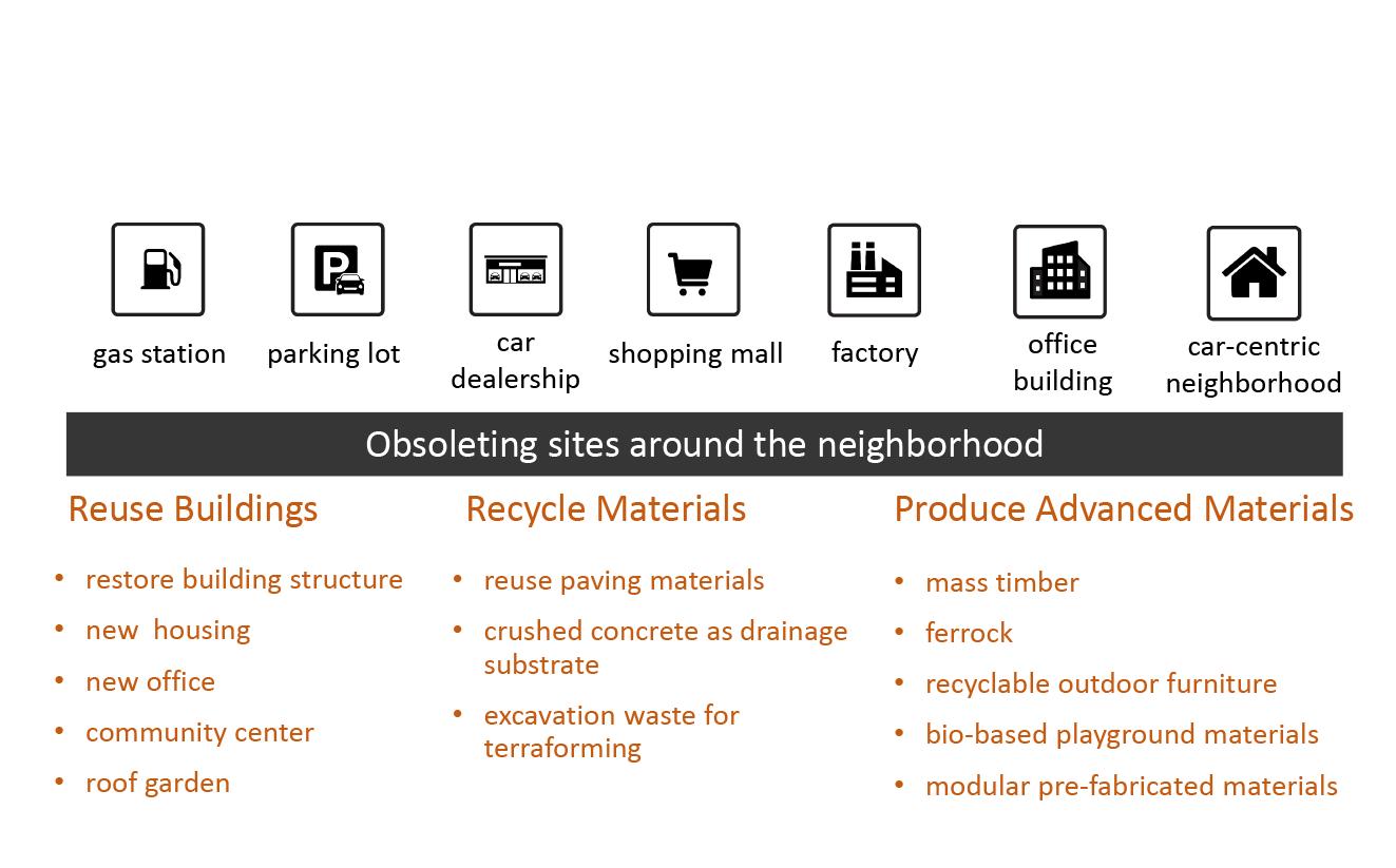
My project aims to reduce the construction & demolition turnover, and increase the use of low-carbon materials. Three principles are set to reach this goal: Reuse existing buildings. Recycle materials. Produce advanced materials. I choose a closed steel mill as my pilot site for the “Material Hub“, and identify seven types of “obsoleting sites“ to be upgraded with materials from the Hub. The upgrading will happen at multiple scales and bring in outdoor furniture, permeable paving, modular housing etc. to the neighborhood.
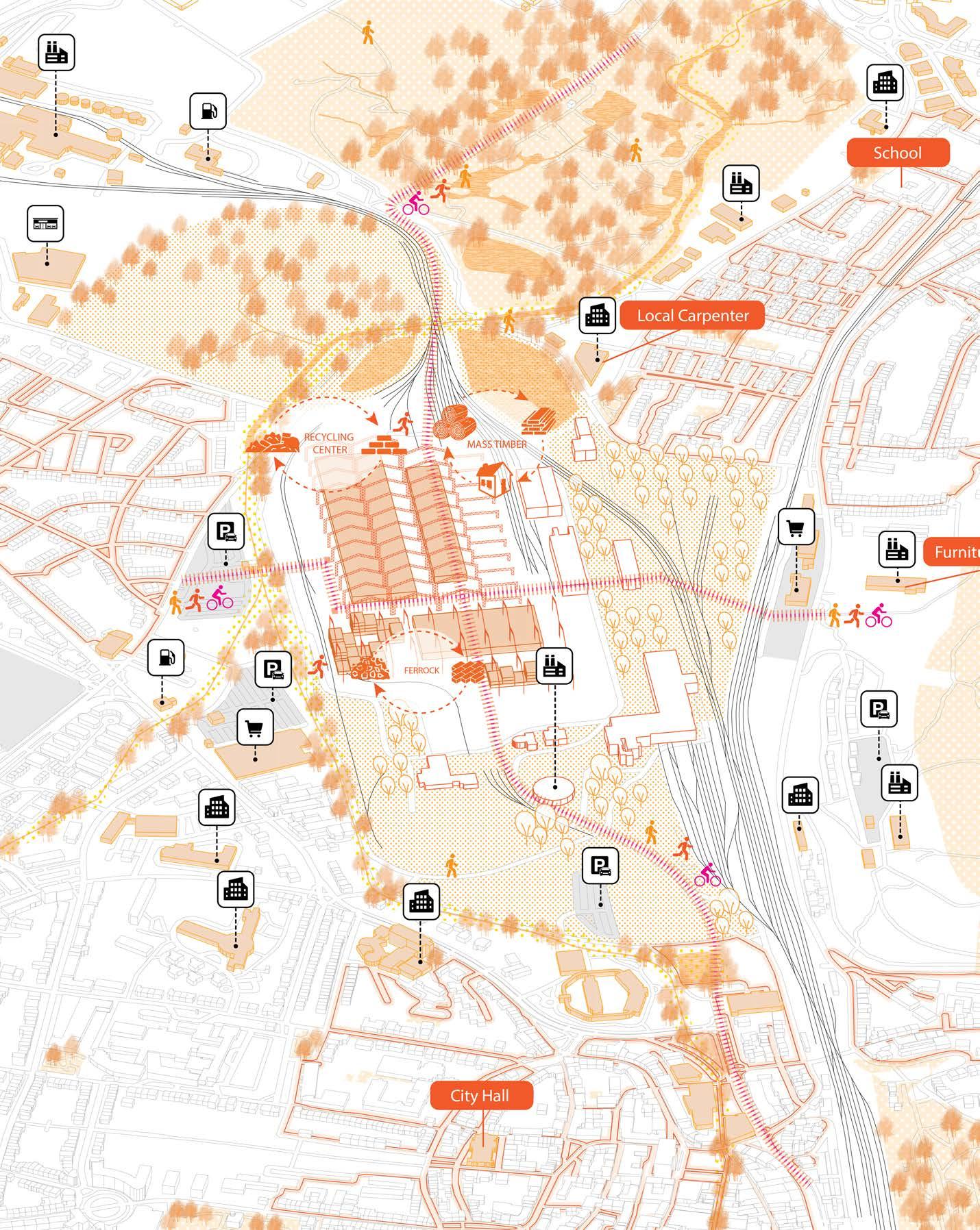
 ArcelorMittal Schifflange, Esch-sur-Alzette
Placemaking Outlook
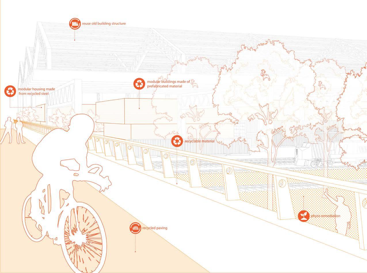
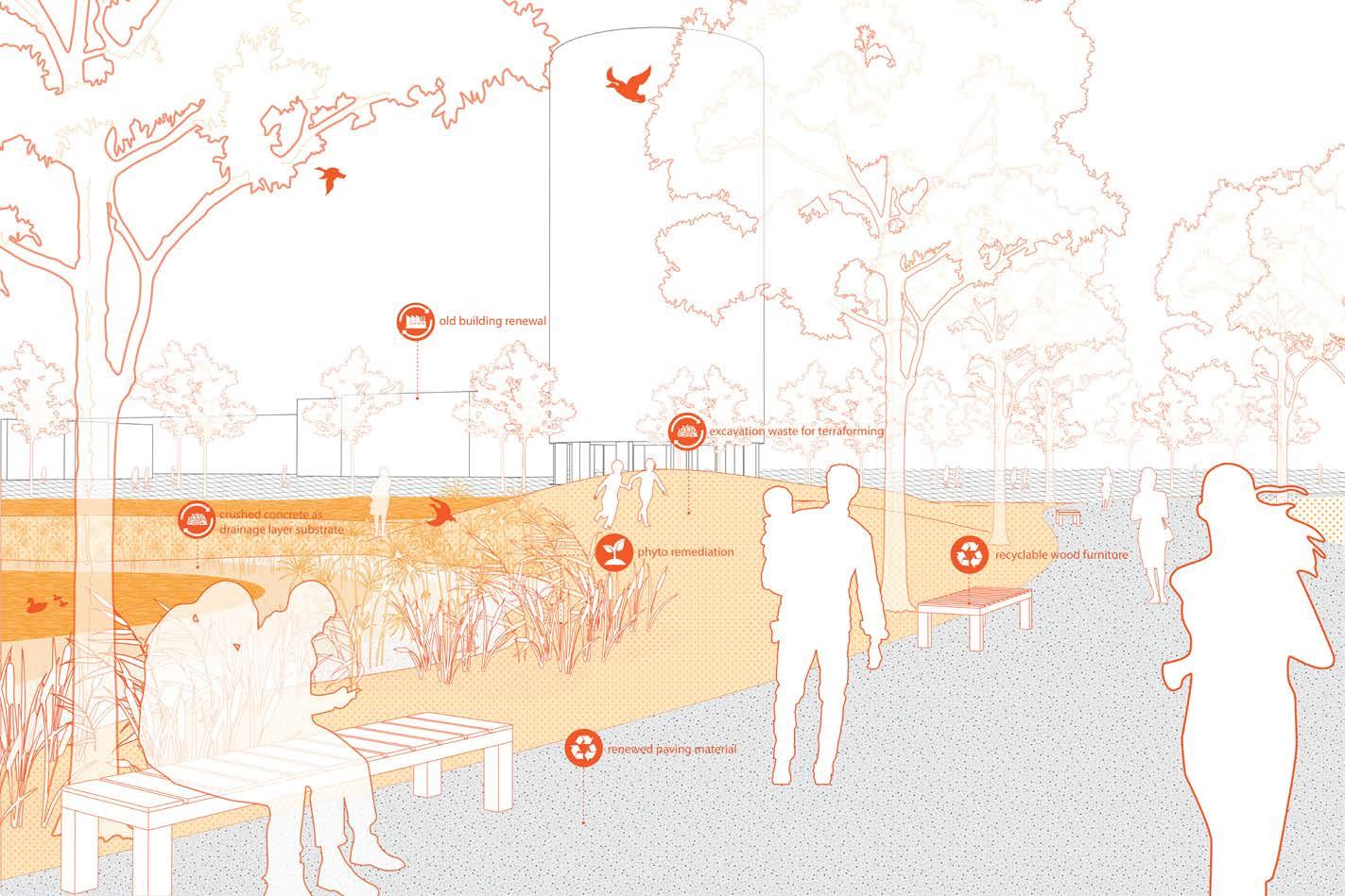
The Material Hub development is twofold: First, site remediation is fundamental. Excavation waste from demolition will become landform-making materials and drainage substrate to support the remediation progress. Second, the Hub will be more than a factory but offer rich community services such as exhibition, shopping and education. Neighborhoods will get better connections and more recreational opportunities with new footbridges and natural trails. Modular housing will be gradually introduced to the site, as remediation finish.
Phase 1: 1-3 years
Phase 2: 5-10 years Phase

2: 10-30
years
Take Actions Right From Tommorrow
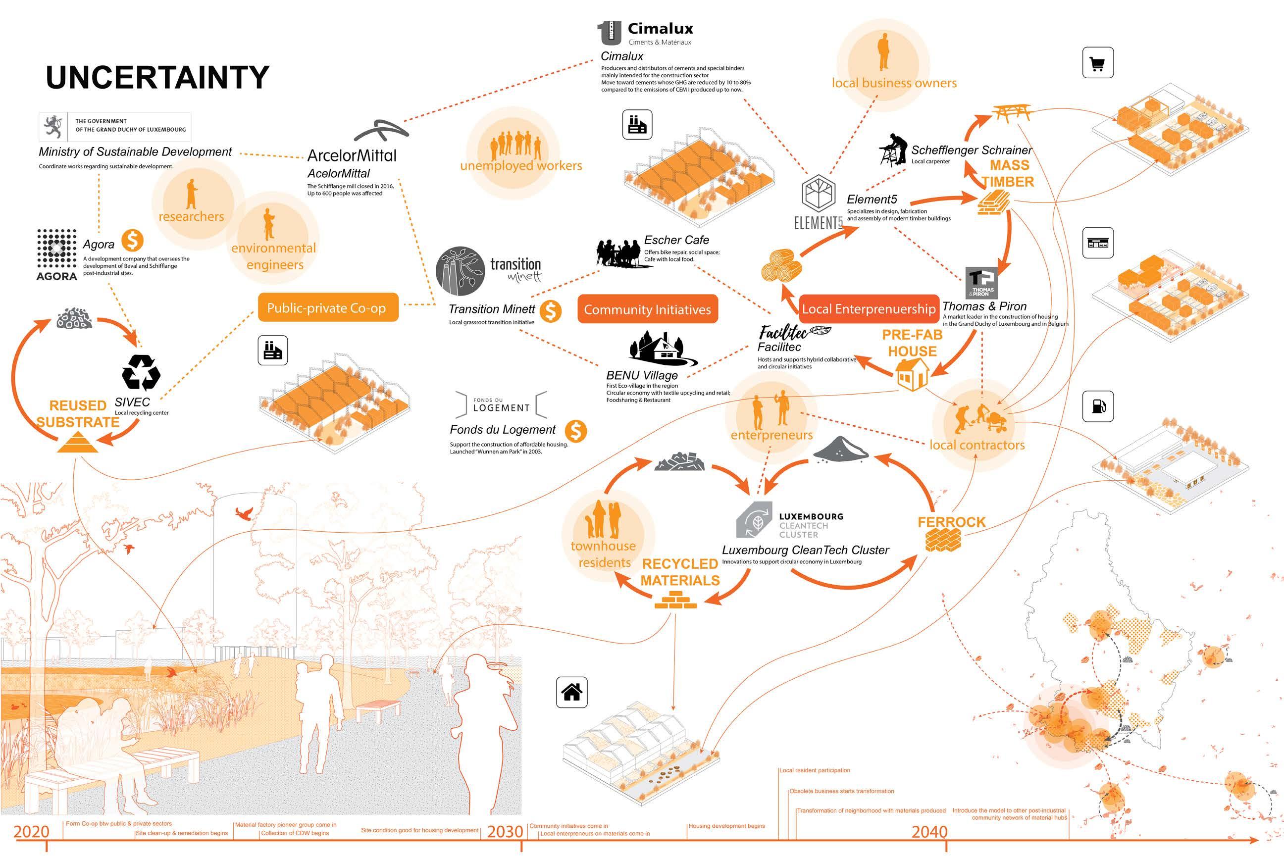
The uncertainty of the future requires us to develop more agile forms of planning and design. Acting instead of only reacting within invisible systems might bare the potential for dealing with the unpredictable future. Transition means working a mode of climate emergency and mobilizing all possible means, and the grassroot initiatives can be the best way to carry out actions.
Wheelabrator Saugus, MA
2From Waste to Green
Goal & Strategies

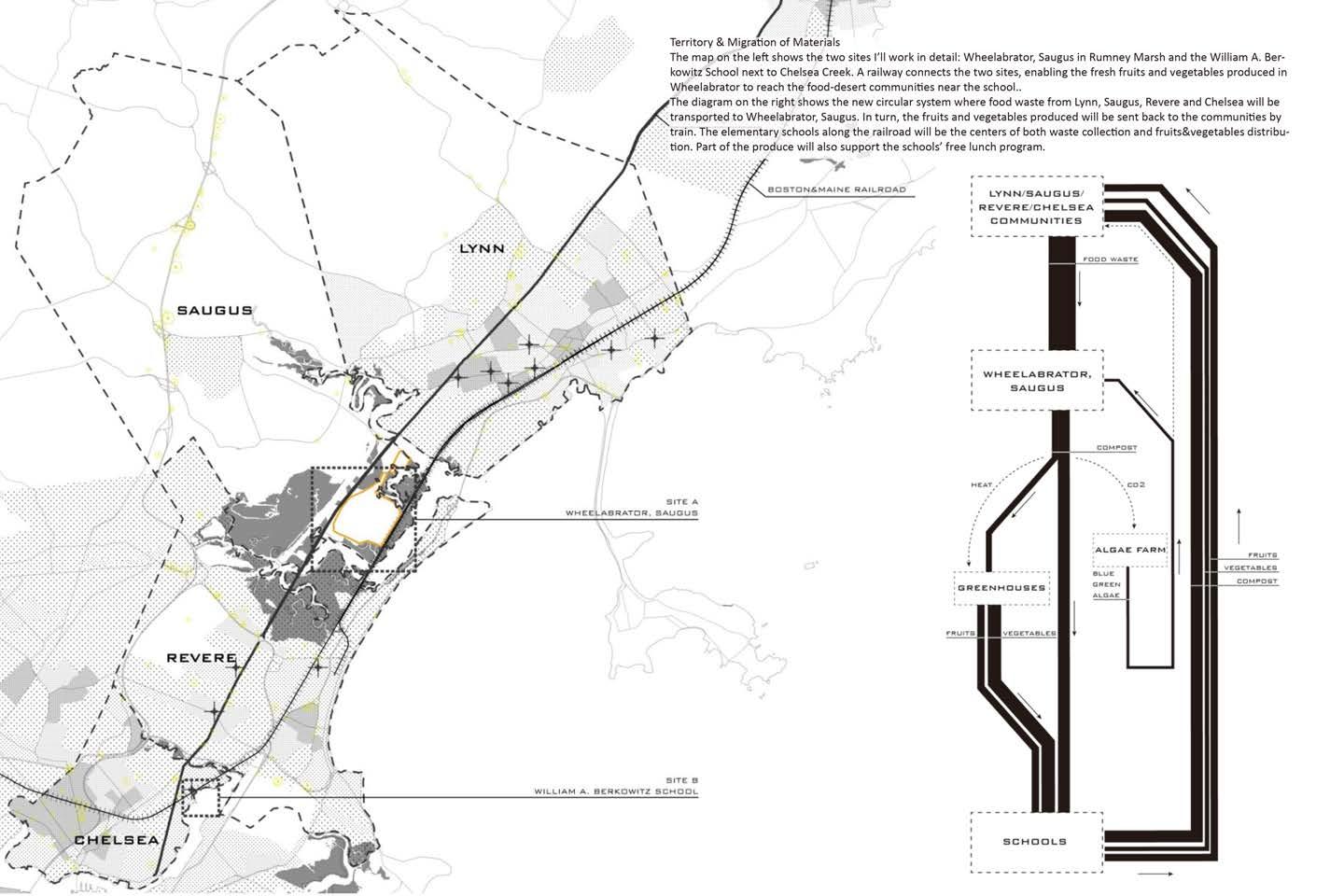
The waste management system in Saugus is. . . wasteful! The Wheelabrator waste-to-energy plant currently receives 1500 tons of organic waste daily. Annually, by burning this food waste, the incinerator produces electricity that can power 4600 households. However, not only is the site threatened by sea level rise, but this process squanders organic material that could be used in far more productive ways. Therefore, I’m proposing a new system that can be adaptive to flooding and produce more valuable products besides just ash. The food waste will be transformed to compost, and the byproducts of the composting process -- CO2 and heat -- will support on-site blue green algae farming and greenhouses. While the blue green algae are highly valuable as raw material for biofuel or superfood, the fruits and vegetables produced in the greenhouses are essential to the nearby communities, too. The fruit and vegetables we consume daily are usually grown in states far away. Not only is food migrating, but people. Many communities in towns such as Chelsea, Revere and Lynn have large populations of recent immigrants and are considered “food deserts”. If we can produce more fruits and vegetables locally, we will be able to reduce food price and support those communities.


Studio
2020
INDIVIDUAL PROJECT SITE
ACADEMIC Harvard Core3
Fall
INSTRUCTOR Prof. Daniel Choi
Migration of People & Produce
Material
& Energy Circulation
Waste Management Facilities vs. Sea Level Rise
Transformthecoastallandfillintoaproductivelandscapeofgreenhouseandalgaefarm
Strategies for Site A
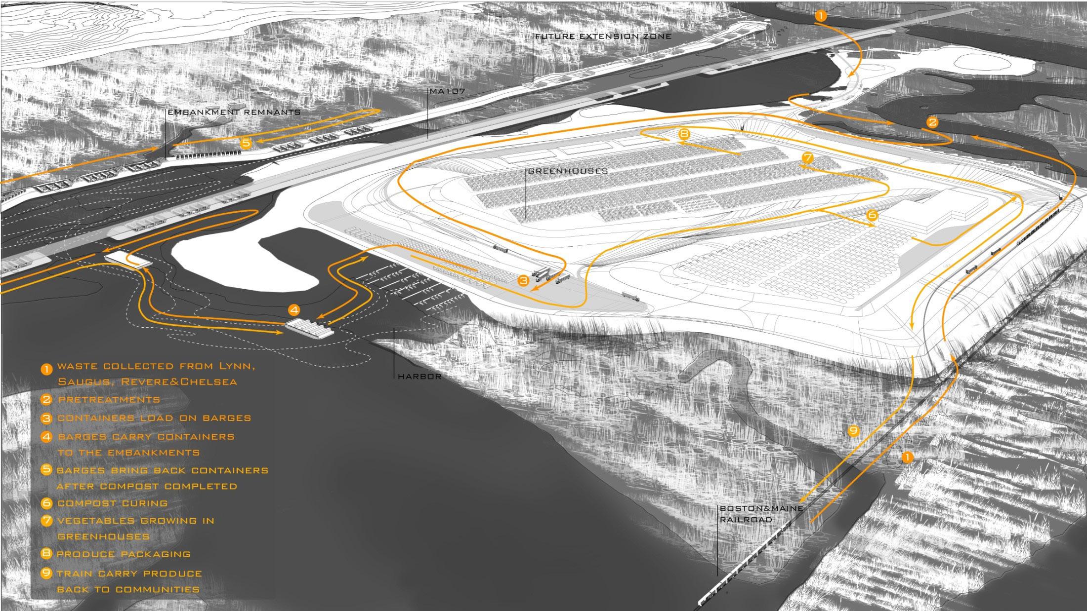
In Wheelabrator, Saugus, I will take advantage of the landfills in the wetland. Currently, the landfills are acting as a barrier to natural water flow. Why not break the embankment down and make it a “holder” for bioreactor containers and algae ponds, while encouraging better water flow? The heat pipes embedded in the embankments can transmit the waste heat from composting to the greenhouses.
The process is color-coded: the algae ponds and the bioreactor containers will change colors as days go by. The container is sized for the current amount of trash. Eight containers will take in 1500T of daily food waste and transform it into compost after 15 days. People can watch this color-changing process from the turnpike next to the site.
Strategies for Site B
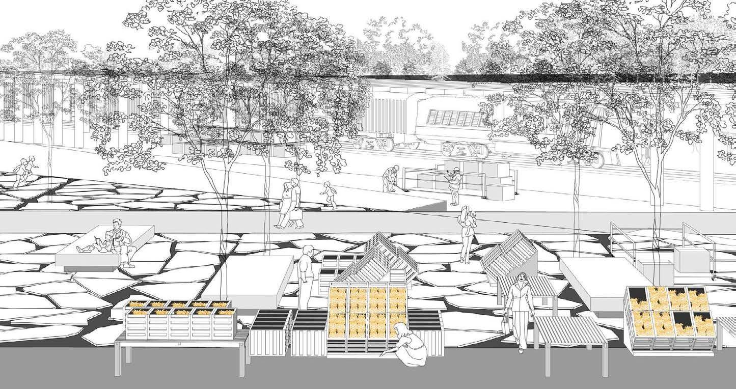
The William A. Berfowitz School is located next to the Chelsea Creek, one of the most polluted water body in Boston. Therefore, in addition to being the center of fresh produce market and food waste deposition for communities nearby, the school should also be the distribution center for the compost that support the remediation of industrial sites along Chelsea Creek.
In the proposal, the street will be temporarily closed during weekends for farmers’ market. I’m also imagining that after the industrial site is removed, it can be transformed to lawn and plaza. I want to use the crushed concrete from demolition to pave the plaza, as show in grey hatch. Fast growing softwoods such as pines will be planted to set up the framework, while lines of slow growing hardwoods will happen in between.
Along the coast, birch groves will intertwine with the restored wetland. The new vegetation system will protect the city from floods.
Here is a view taken from the plaza to look through the railway platform. A low wall on the edge will protect schools from traffics. With the market, the benches, the tree shades and the carts hear and there carrying boxes of fruits and vegetables, the place will be bustling.
 INSTRUCTOR Prof. Jennifer Birkeland
Bergen Arches, Jersey City, NJ
Tube City
Maketheabandonedrailwayanurbanamusementparkwithintertwininggreen&greyinfrastructures


During this Urban Design Studio, we were challenged to look at the potential of urbanism through the lens of landscape. Embedded in a complex urban context in the neighborhood of Jersey City, the site we worked on contained two distinctive parts: the Embankment and the Arches. Both as part of an abandoned railroad system, the Embankment was a segmented masonry and earth structure around 3 stories above the ground, while the Arches was a railroad trench around 5 stories below its urban context. Our goal was to transform this underutilized space into a public corridor that can benefit the existing community.


Goal & Strategies
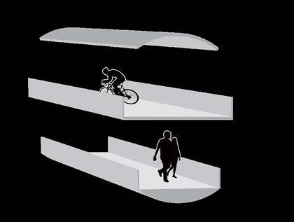
The goal of my design is to reduce the burden on current storm drain system caused by intense rainstorm, meanwhile offer people an all-weather pathway. Judging from their location and soil drainage capacity, I decide that the Embankment and the Arches should develop in different ways. Located in the middle of a prosperous community, the Embankment should serve as a flood-resistant community center with outdoor and indoor recreational spaces. The Arches, with its sunken landscape, is good for holding water for the upland area. An all-weather path will connect both sites, enabling people to travel between work and home with enjoyable experience. Tubes, with its strong guidance quality, become a tool to manage both the flow of water and people.
Site Analysis
Terrain& Soil Drainage Capacity
Flood Zone Storm Drain System Green Space
Section of the Embankment
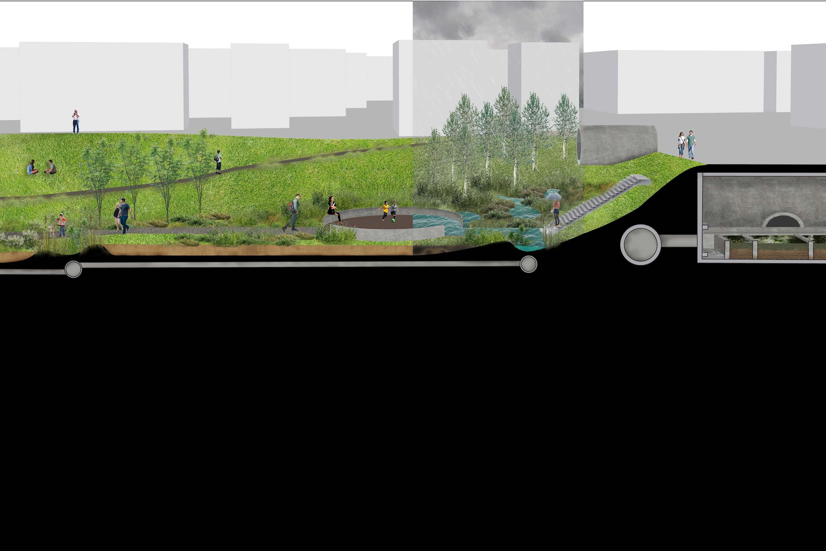
This drawing visualize my crazy idea of a “Tube City”. Tubes become container for both water and human activities. Though the intervention may be too bold to be carried out, it gives me a chance to rethink about the relationship between architecture, infrastructure and landscape.

ACADEMIC Urban Design Studio Fall 2019
INDIVIDUAL PROJECT
SITE
3
Site Plan of the Bergen Arches

Playground SkateparkSandFilters
Main Focus-The Arches

Upgraded Parkings
Planting Zones
Circulation&Entries
CommunityGreenhouse &CommercialCenterUpgradedParkingLot&CommunityOpenSpace
All-weatherPathway Buffer EntryPlaza
BasketballCourt
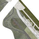
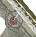
About 50’ below its urban context, this sunken landscape is ignored by even people living next to it. To create more connections to surrounding communities and give people easy access to the Arches, I soften the southern edge of with cut and fill and created several ridges and valleys. The ridges will connect to the previous underutilized parking lots and form entries for communities. The valleys will function as bio-swales and treat runoff from those communities.
Grey & Green Infrastructure System
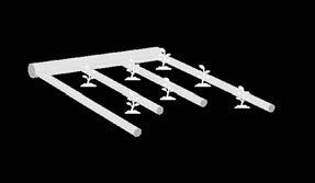
In this proposal, grey and green infrastructures work together to manage storm water. Underground, the old railway tunnels will be connected to the re-oriented storm drain system and become cisterns for runoff. Inside the cisterns, the gross firstflush will get a centralized treatment before getting into the irrigation system. Above ground, the landscape are terraced and planted with different species so as to absorb different pollutants from the water.


Concept Formation

Step 1: Locate underutilized parking lots
Step 2: Cut and fill to creat ridges and valleys
Step 3: Terrace the ground and plant according to soil humidity
Step 4: Lay out pathways and entries

Infrastructure Systems
Longitudinal Section of the Bergen Arches
Grey & Green Infrastructure Layout
After
Water Storage
After Intense Rainstorm
Planting Strategy
Shrub Buffer: Capture dust and other larger particles


Grass Mat: Infiltrate smaller particles
Deep Root Grove: Stablize pollutants

Normal Rain Event
Rainfall Intensity in 100yr Rain Event= 3.0 inches/hour
Proposed Drainage Area= 870,000 ft sq



Peak Water Volume= 21,500,000 gal



Tube
Proposed Drainage Area
Typology
Storm Drain Pipe Sand Filter
Observation Deck
Cistern Collection Tube
All-weather Pathway
Irrigation
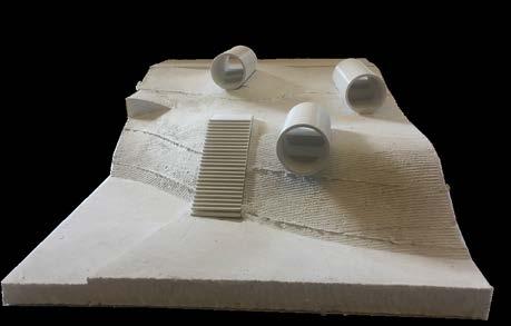
Working Model
Tubes for Water Management
Section Perspective 1
Tubes for Recreation Activity


Section Perpective 2
Views from Observation Deck and Pathway Tube
Uzima: Spaces of Nourishment & Healing


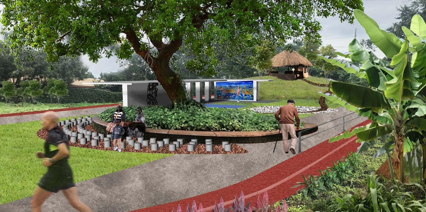
This 2.2 acre hospital-based garden at Kilimanjaro Christian Medical Center (KCMC) in Moshi, Tanzania is designated to support the reflection, healing, teaching and research about the links between ecological and bodily health. In Kiswahili, uzima means holistic health. The garden design will support faculty and students in their efforts to articulate “uzima” and acknowledge the complex notions of health engaged beyond the clinic.


Design Concept


We are not simply nourished by the soil, we are of the soil. The carbon, nitrogen and every mineral and vitamin that is a building block in our own bodies is derived from soil. Therefore, the soil remediation progress will not only initiate ecological restoration, but also inspire new understandings of the healing of human beings. The goal of my design is to improve soil quality of the site, and at the same time provide doctors and medical students an experimental ground where they can gain knowledge about plants, soils and environments needed to assess their contribution to health and healing.
Challenges & Approach


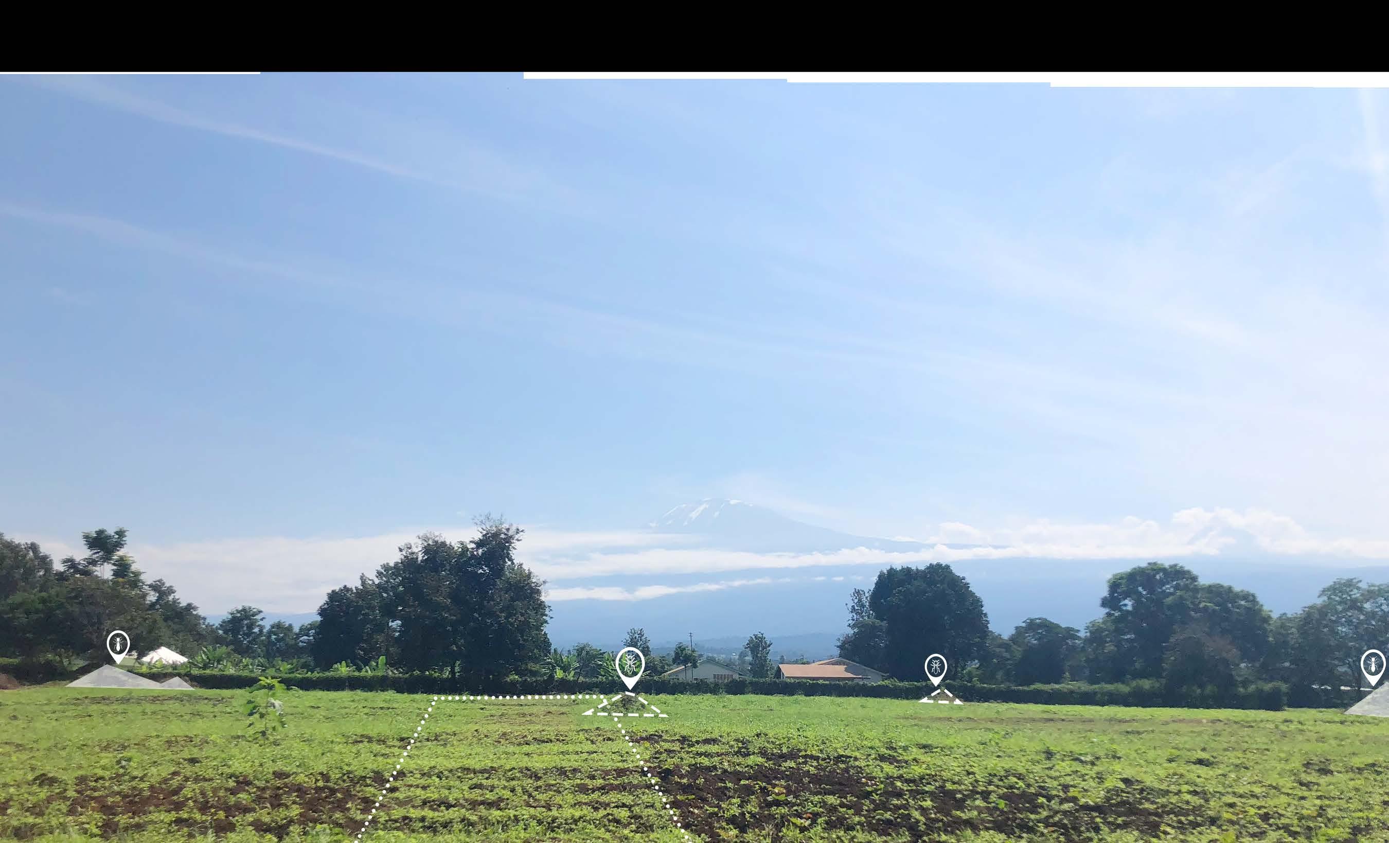
Termites turn out to be the biggest problem of the site, therefore become the starting point of the soil remediation progress. Termites deplete the soil by moving nutrients from the foraging area to their own mound. However, researches suggest that local people have learned to live with termites for a long time. Traditional agricultural practice such as intercropping and crop rotation can increase termite repellency. Learning from such termite-control methods, my design actively takes advantage of the termite mounds on site and offer practical methods to reduce termites’ negative effects.

Design Research Summer 2019 INSTRUCTOR
INDIVIDUAL PROJECT SITE Moshi, Tanzania 4
ACADEMIC Independent
Prof. Stacey Langwick (anthropologist)
The site currently uses soy bean as cover crop to fix nitrogen and remediate soil
=Termite inactive mound Activity & User Survey Summary Sanctuary Patients Medical Students Family & Friends Doctors Communities Teenagers Connection Reflection =Termite active mound Setupatherapeuticgardentotestifylocalholistichealthnotions
The view of Mt. Kilimanjaro from site is instrumental to healing
Termite Control Strategies
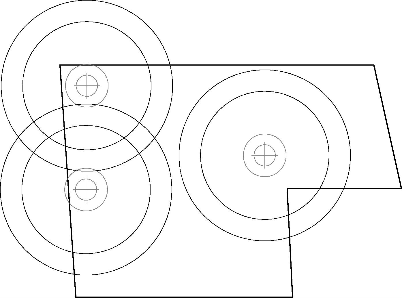
According to the studies on termite habit, the main foraging zone of termites is 10m-40m from the mound, where the soil suffers from nutrient depletion. However, the soil in the inner circle (within 10 meters from the mound) is free of foraging and stays nutrition-rich. The difference in soil condition results in completely different vegetation types. Therefore, my strategy is to create termite-repellent landscape in the outer circle, meanwhile set up symbiotic relationship between termite and plants in the inner circle.
How to live along with termites?
Mound with closed ventilation system
Inner Zone with shallow passages underlain by deep radial passages
Main Foraging Zone with network of radial and cross passages


Peripheral Zone with small passages after ending blindly
How to deal with the mounds?
Remove the mounds + Spread mound soil to enrich surrounding area
Offer adequate alternative food sources

Compost Plant Litters
Keep the mounds
+ Set up symbiotic relationships


Raize the termite resistance of the landscape
Manure
Use termite-repellent plants

Intercrop repellent and susceptible species

Rotate between repellent and sesceptible species


Build physical barrier with sand/concrete/ raised planters

1m 5m-10m 30m-40m 50m
Learn from Local Agricultural Landscape


Smallholder farms on Mt. Kilimanjaro, also named “Chagga Homegarden”, contain a variety of landscape types. Some types in kiswahili words have implications of complex dynamics between human and nature which cannot be translated directly. They set a good example of how to make best use of resourses, protect biodiversity and raise resiliency in agricultural practice.
Tuber Crop Plot
-Small plots relatively far away from house

-Intercropping of bean, sweet potatoes and corns


Shamba
-Field
-Lower on the mountain
Buscani
-Something small, not like a farm
-A grassy space always with flowers
-Has to be around the house
Kihamba
-Homesteads in the Kiliminjaro region (up the mountain)
-Small plots surrounding their house
-Both cash crops and fresh vegetables are planted


Kitchen Garden


-Can pick fresh vegetable on a daily basis


-Abundant collection of local varieties of plants


Fresh Fruits & Vegetable
Medicinal Plants


Crop Crop
Ornamental Plants
Timber
Design Strategy


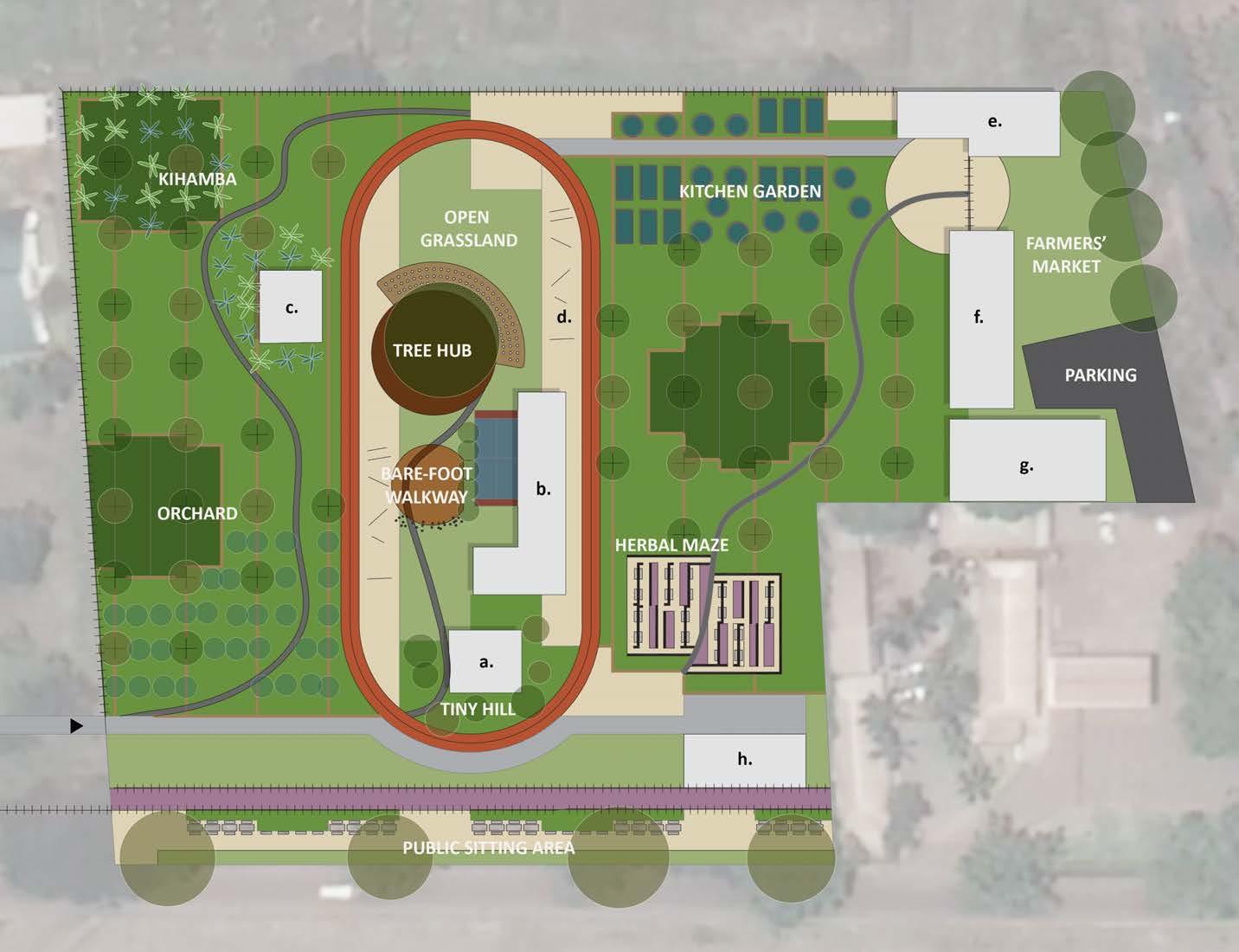
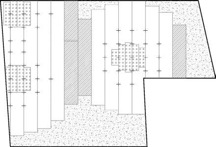
The strategy of strips defines the spatial organization of this design. The 10m-wide strips origin from the layout of agricultural field, and the concept gets further developed after I did some case studies (Parc de la Villette by Rem Koolhaas; Schouwburgplein by Adriaan Geuze). Each strip becomes individual unit in the whole composition with its own inner definition and structure. The strips can be united or subdivided flexibly and still be united and answer to the programmatic needs.
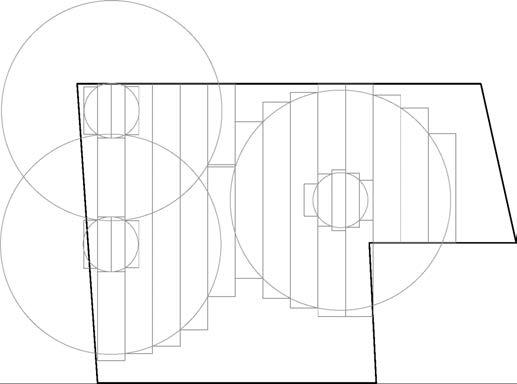
Arrange the use of plots according to its relation to termites

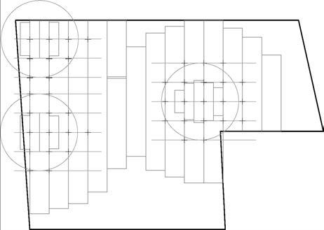
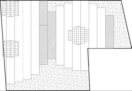
Merge the layers
Foraging Zone: Strong Termite Repellent
Controlled Development: Relative good tepelliency, have activity space soft landcover
Multi-use Area: Termite inactive zone; good for hard pavings and buildings
 Termite mound: Symbiosis
Set up the construction of garden with arrays of fast-growing trees
Identify the influencial circles of termites
Step 1:
Divide the circles into plots
Step 2:
Step 3:
Step 4:
Step 5:
a. Pavillion
b. Art Trellis
c. Tool Shed
d. Rehabilitation Facility
e. Seed Bank
f. Community Activity Center
g. Storage
ENTRY
h. Restroom


 ArcelorMittal Schifflange, Esch-sur-Alzette


 INSTRUCTOR Prof. Jennifer Birkeland


 Termite mound: Symbiosis
Set up the construction of garden with arrays of fast-growing trees
Identify the influencial circles of termites
Step 1:
Divide the circles into plots
Step 2:
Step 3:
Step 4:
Step 5:
a. Pavillion
b. Art Trellis
c. Tool Shed
d. Rehabilitation Facility
e. Seed Bank
f. Community Activity Center
g. Storage