[ Chenxi Wang ] PORTFOLIO
Selected Works
2018-2022
For the application to MLA at the University of Edinburgh
Chenxi Wang ]

Phone: +(86) 17835460320
E-mail: wcx1304382116@gmail.com
Address: No. 50, Chengdong Road, Taihang East Street, Changzhi City, Shanxi Province, China 046000
Southeast University, Nanjing, China,Sept. 2018 - Jun. 2023
Bachelor of Engineering in Landscape Architecture
GPA: 3.75/4.0
Internship
- Shanxi No.3 Building Engineering Company Changzhi Branch Architectural Design Institute;
Aug. 2022 - Oct.2022
- responsible for architecture construction drawings and facade design for a hospital construction project;
2022 Imperial-RCA Design for Global Challenges Online Summer School
- Most Innovative Design Award;
- an A-Distinction for the individual;
Jul. 2022 - Aug. 2022
- finished a two-week online course; carried out group service design around Climate Change and completed a final presentation;
Research Program, Southeast University
- “Application of Dynamic Fitting of Digital 3D Model in the Study of Stacked Mountain Technique “; - team leader;
Nov. 2020 – Nov. 2021
- through the dynamic fitting of three-dimensional digital models, taking "Pu" Garden rockwork as the research object, using the parameters in the image correspondence to generate three-dimensional information, combined with an interview with the rockery craftsman Fang Hui, to a certain degree of visual interpretation of the stacking technique reflected in the rockery;
- written paper “Application of Dynamic Fitting of Digital 3D Model in the Study of Stacked Mountain Technique -- Take Kunshan "Puyuan" rockery as an example”;
Ancient Buildings Measurement surveys, Southeast University
- team member
Jul. 2021 - Oct.2021
- did fieldwork and measurement for the traditional landscape architecture in Lu Garden, did online measurement surveys for Master of Nets Garden;
- 3D model, detailed plans, sections and facades of the buildings and classical gardens, video;
Volunteer Experience
- 2021 Jiangsu Red Cross Registered volunteer
- Teacher role in school-related subjects (art, English, science) in Xuanwu Community Service
3D Modelling: Sketchup / Rhino / Grasshopper / Blender
2D: AutoCAD / Adobe Photoshop / Adobe Illustrator / Adobe InDesign
Analysis: ArcGIS
Rendering: Lumion / Enscape
Oct. 2021
[
[
] [ Work
] [ Professional
] [
]
Education
Experience
Experience
Skills
"Why this major?"
"Why persist and love ?"
"What kind of landscape architect I'd like to be?"
These are the questions I'm constantly looking for answers to, and the reason I choose the University of Edinburgh.
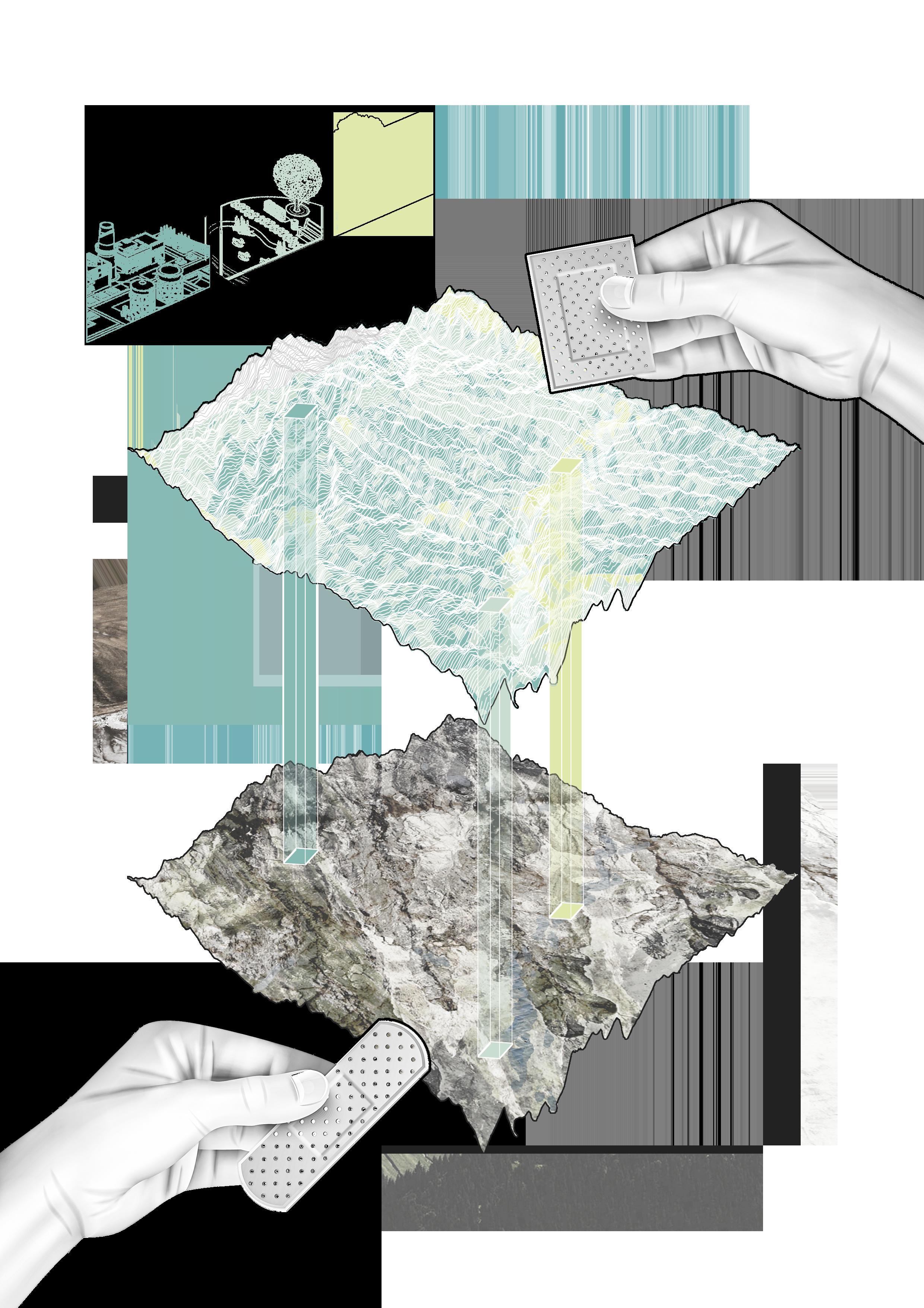
Born in a small town in Shanxi Province, the largest coal-producing province in China, my daily life seems filled with the billowing smoke from the chemical plants and the smoky haze shrouding the sky. Facing the scarred land under my feet, I think landscape design is the best solution to restore the ecological environment and build a livable city. This is my original intention in choosing Landscape Architecture as my major.
During my five years of undergraduate study at Southeast University, its rigorous and practical landscape teaching system has taught me how to be a down-to-earth problem solver in landscape design. In my fourth year of undergraduate study, I participated in landscape planning projects for ecological restoration. This topic triggered my rethinking of the ecological issues in my hometown and finally derived into my academic interest in Ecological Landscape. Landscape architecture is a powerful weapon in both the broken ecological environment and the built environment of cities, which I learned through this experience. The purpose of green spaces should not be only to beautify urban spaces, but also to restore or improve the ecological environment. By using expertise and technology, a landscape architect can gently balance urban construction and the ecological environment in a wide range of sociocultural and socioeconomic contexts.
I wish to enter Landscape Architecture at the University of Edinburgh to study MLA. I really appreciate the teaching philosophy of the University of Edinburgh, which has always been adhering to the whole field, multi-scale, exploring multiple possibilities of space design, combining artistry with theory and practice. What I am most looking forward to is the interdisciplinary course design of the Department of Landscape Architecture, which not only includes theoretical courses such as landscape history, botany, ecology, geography, and detailed design, but also combines Edinburgh's ecological characteristics with a large number of field trips. In the future, I hope to consider the relationship between human behavior and cities from the perspective of nature. As a landscape architect and researcher, I will conduct in-depth research on sustainability and ecological landscape projects.
1 [ MOTIVATION
]
LETTER
CONTENTS ] 01 / HEALING EARTH SCARS A mine park design based on GIS analysis 02 - 11 02 / INVERTED PYRAMIDS A digital deisgn for a community that makes a living from e-waste 13 - 23 03 / WEAVING RIVERS A resilient landscape design oriented by flood adaptability 24 - 33
[
2 IndustrialArea Landscape ConstructionArea ForestConversation Area ConstructionElevenAssessment OriginalTopography
01
Healing Earth Scars
Mine park design based on GIS analysis
Acadamic Work
Jijiagou Village, Taiyuan, Shanxi, China
Individual Work
Tutor: Pang Li April 2020
The site locates near Jijiagou Village in Xishan District, Wanbailin District, Taiyuan City, Shanxi Province, covering an area of 396hm2. The ecological problems caused by coal mine goaf in this area are the most prominent. In the regional context of the resource-based regions in Shanxi Province, affected by China's policy of vigorously developing ecological civilization, the Xishan area is facing the need for environmental restoration and scenic spot construction. With people's pursuit of quality of life, suburban parks with a good environment have gradually become the places of leisure and entertainment that people yearn for.
Due to the site's large-scale geographical scope and complex mountainous terrain, to achieve ecological restoration, activation of regional tourism resources, and objective and reasonable regional landscape transformation, this project adopts the GIS to analyze this site. After analyzing the slope, elevation, aspect, and land use of the restricted terrain, it is more reasonable to decide on the landscape reconstruction process of the abandoned coal mine land.
3
China's coal industry Coal export /Coal import proportion /Coal production and reserves in China
Chinese coal mainly exports to Asian countries such as Japan and Korea.
The source countries of China's coal imports mainly include Indonesia, Australia, Russia, Mongolia, etc
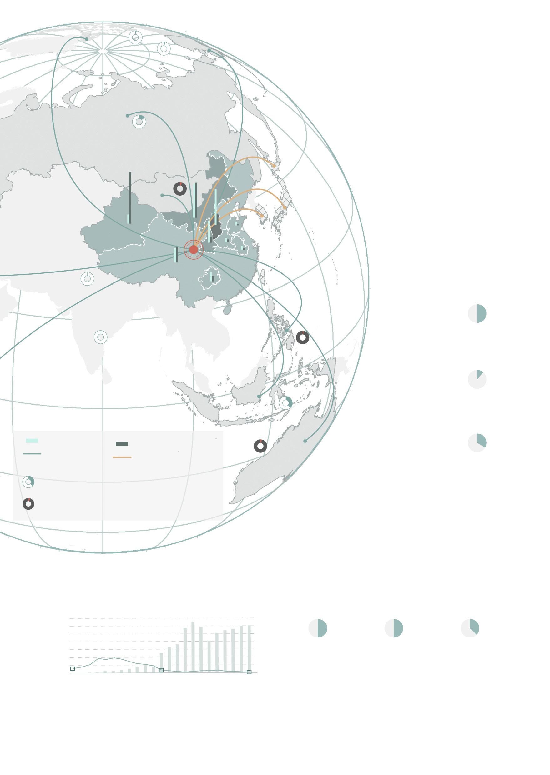
Regarding the distribution and reserves of coal resources, China's regional distribution is highly uneven, mainly distributed in Xinjiang, Inner Mongolia, and Shanxi.
China accounts for 50% of the world's coal consumption.
China accounts for 13.3% of the world’s coal reserves.
Coal production
Coal import
Coal reserves
Coal Emport
Proportion of coal exports to China in 2020
Coal exports to China showed an increasing trend from 2019 to 2020
Coal exports to China showed an decreasing trend from 2019 to 2020
In current situation
China accounts for 51% of the world’s coal production.
50%
13.3%
51%
World Coal Consumption World Coal Reserves World Coal Production
China's oil and natural gas resources are relatively insufficient, with proven oil recoverable reserves accounting for only 2.4% of the world's total and natural gas accounting for 1.2%. In comparison, coal accounts for about 14%. Such resource conditions determine that China's energy structure dominates by coal.
China's coal imports and exports
Before 2007, China imported a small amount of coal and was a coal exporter. Since 2007, China's coal exports have been lower than imports, becoming a coal importer.
China’s energy structure
According to the graphs above, we can see that the leading energy consumed in China is coal.
4
350 300 250 200 150 100 50 1998 2007 2020 U n i t / M i l l i o n t o n s 85% 67.6% 59% Coal Consumption in renewable energy consumption Renewable Energy Consumption in energy consumption
Consumption in energy consumption
Coal
Canada America
China Russia Mongolia
Hongkong Korea Philipines Colombia South Africa Indonesia Australia Japan
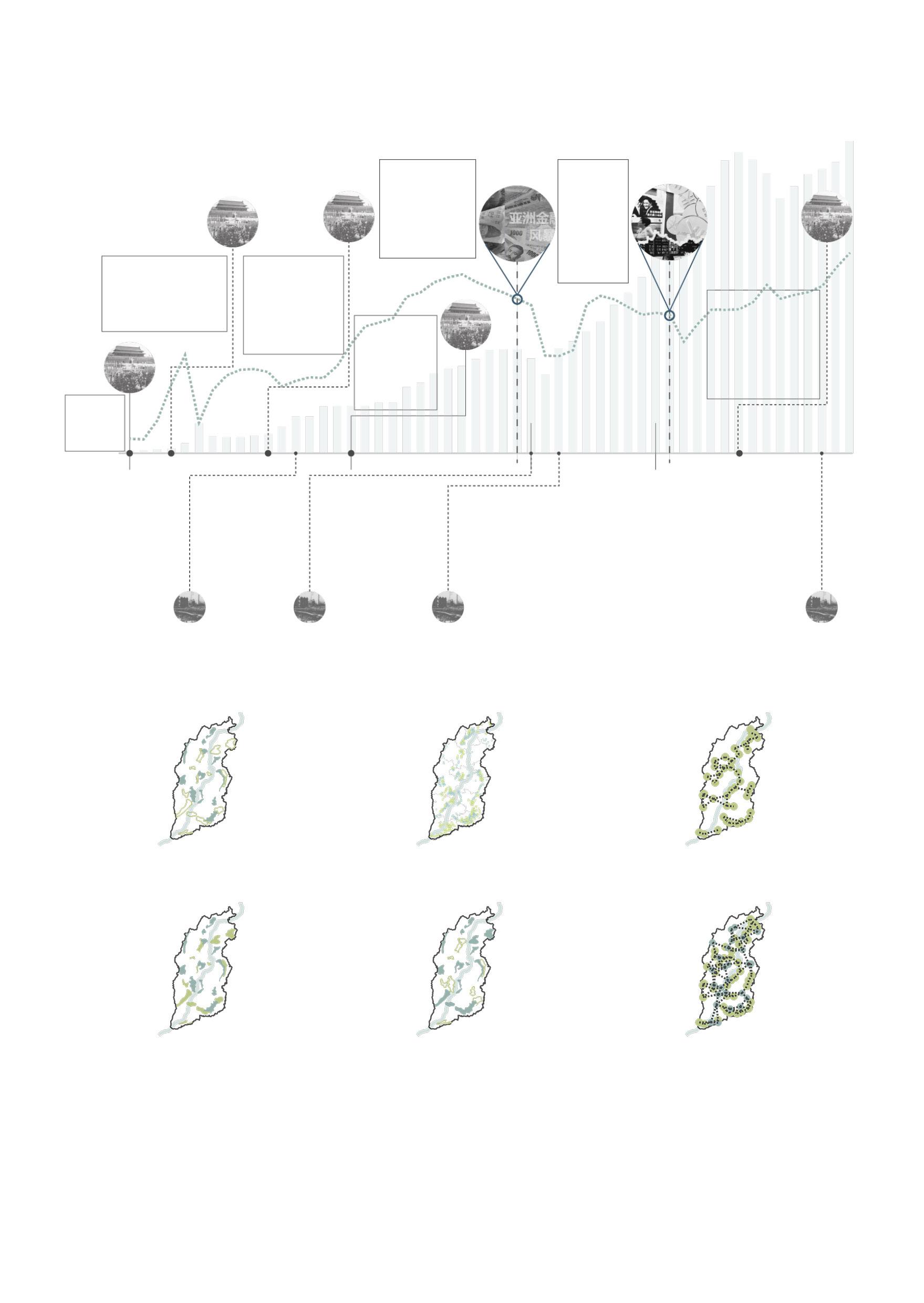
After 1970, the level of coal mining mechanization in Shanxi improved, and coal production increased.
In 1998, Shanxi adjusted the coal production and transportation order and closed unreasonable coal mines.
After 2000, Shanxi carried out the integration of coal mine resources, and coal production gradually recovered.
Landscape Planning
of Shanxi abandoned mines
"Shanxi Provincial Mine Environmental Governance and Restoration Fund Management Measures" forms a solid institutional constraint on the performance of mining rights holders on the obligation of mine ecological restoration.
Phased Governance
The restoration will carry out in stages. It expects the green space construction of mines with less ecologi cal damage and the fundamental ecological restoration will be completed by 2040.
Ecological Restoration
According to the destruction of abandoned mines in Shanxi, the areas that need water restoration and landform landscape reconstruction will be defined in 2040.
Green Space System &Tourism Linkage
Through the landscape construction of abandoned mines, it is expected that in 2040, the mine parks will link the eco-tourism resources with the surrounding parks to form an ecotourism network system.
5
2022 2022 2022 2040 2040 2040 The three-year Great Leap Forward The foun -dation
The Cultural Revolution The reform and opening-up policy The National
Ecological Environment Restoration
Governance
The
of New China
Mine
and
Site Meeting The Asian Financial Crisis
International financial crisis
1949-1980 1980-1998 1998-2007 2007-
The development process of Shanxi coal industry
Site analysis based on GIS
Second-order Factors
First-order Factors
The point in the middle of the pixel grid is selected as the sample point, and the construction suitability index at the sample point with high height and dark color is high.
The point in the middle of the image grid is selected as the sample point, and the ecological sensitivity index of the sample point with high height and dark color is high.
Results Analysis
According to the GIS analysis results, the four more representative sites in the site were selected as samples. These four samples adopted different design strategies.
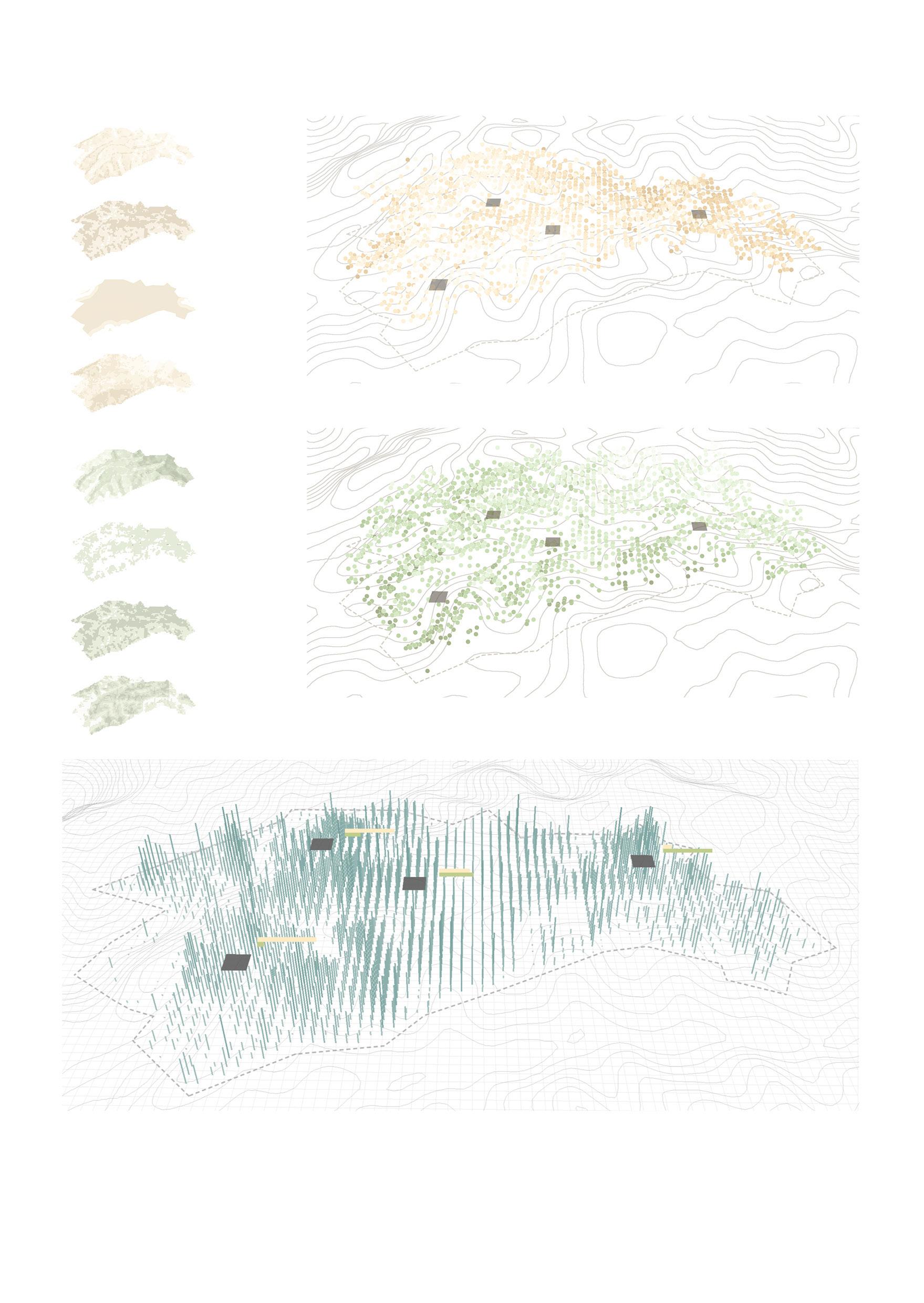
Sample 1 has excellent construction suitability, and the ecological sensitivity is extremely low.
Sample 2 has a high overall value, high construction suitability, and low ecological sensitivity.
Sample 3 has higher construction suitability and higher ecological sensitivity.
Sample 4 has extremely low construction suitability and high ecological sensitivity.
6 Topography Land Use Vegetation Hydrology Topography Coverage Transportation Attraction ×0.2 ×0.2 ×0.1 ×0.1 ×0.3 ×0.2 ×0.4 ×0.5
Sample 1
Sample 2
Sample 3
Sample 4
Design Strategies
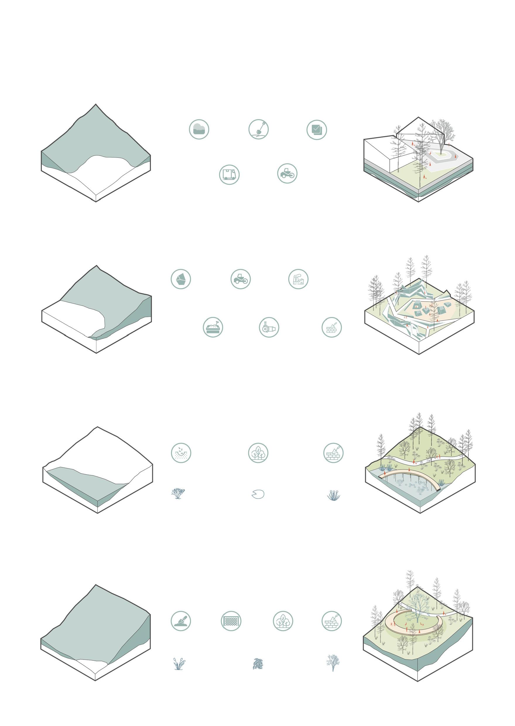
Strategy1 Coal Mine Museum
Gangue Backfill
Backfilling and subgrade materials enable the bulk consumption of gangue with low pollutant content, reducing the cost of construction of roadbeds, foundations, or dam foundations and reducing the land occupied.
Lay Gangue
Check Transportation Leveling
Strategy2 Mine Exploration Park
Gangue Reusage
Gangue can be used to prepare building materials to build park structures, mainly brick making, etc. When making bricks, the explosive substance of gangue can save coal, forming a virtuous circle.
Crush Gangue Stir to mix
Leveling Roasting Dry Build
Strategy3 Artificial Wetland Park
Gangue Acid Wastewater Treatment
Gangue can produce acidic wastewater, which causes soil, surface water, and groundwater pollution and seriously affects plant growth. Alkaline materials such as fly ash can be sown to neutralize with acidic substances in gangue, followed by the construction of wetlands.
selection Plant Configuration Trestles Construction
Gangue Add Alkaline Substances Submerged Macrophyte Floating Plant Emergent Aquatic Plant
Strategy4 Land Art
Ecological Restoration of Gangue Mountains
7 1 1 2 3 4 2 1 2 3 3 4 5 1 2 3 4 5 6
mountain
For gangue that cannot be comprehensively utilized, ecological restoration is required. Gangue mountain has a significant slope area; due to the poor engineering stability, ecological planting blanket technology can be used to enhance strength and use plant configuration to fix the soil further. Then gangue mountains can carry out a certain degree of engineering construction. Slope Shaping Ecological Planting Blanket Plant Configuration Structure Construction Shrub Arbor Herb
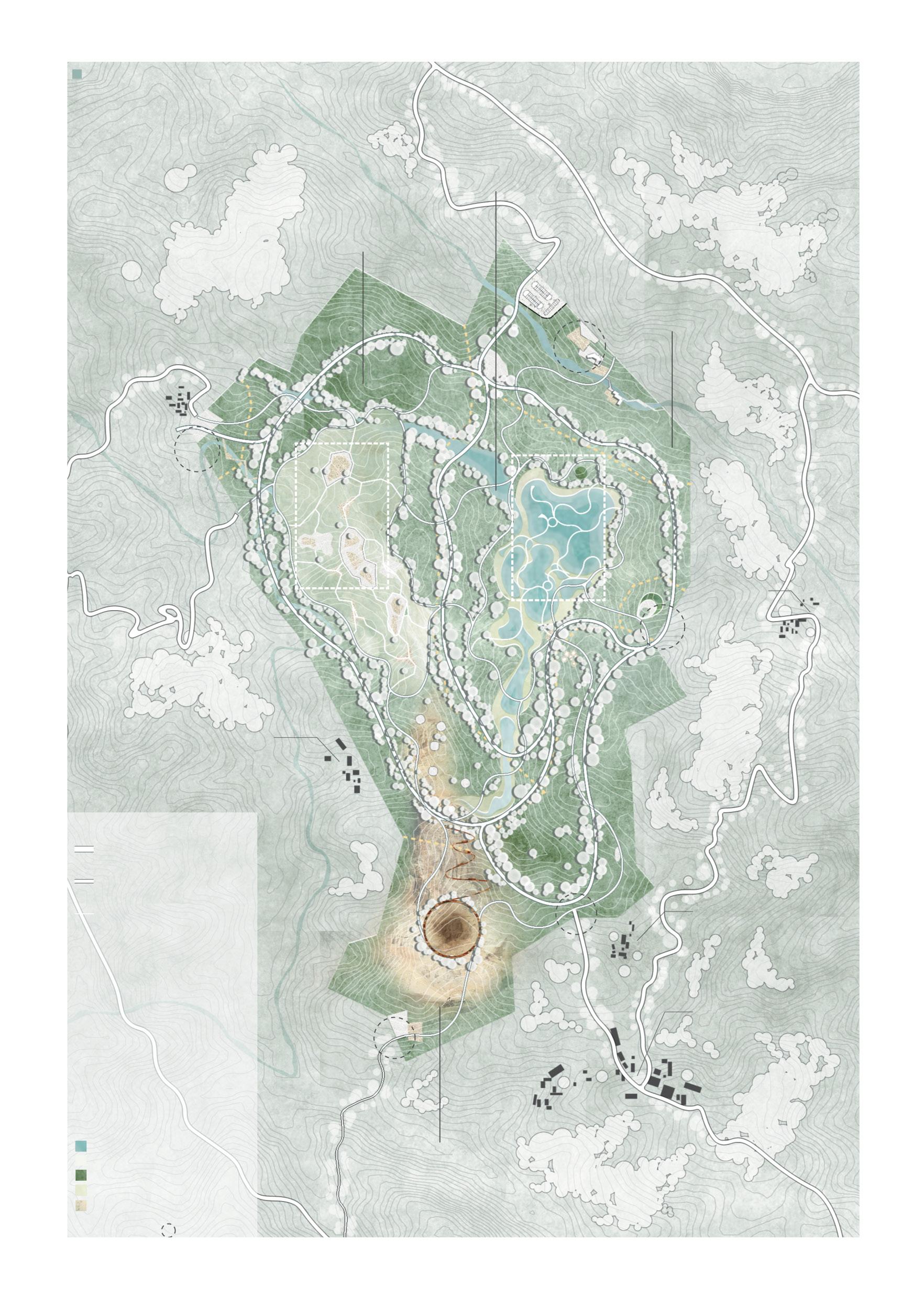
N 8 A B C D E F G H Feature Entry Area Waterfront Square Man-made Wetland Park Colliery Museum Mine Exploration Park Trestle and lookout Land art Tree House Water Area Hard Paved Foors Forest Wetland Plants Pit Area Road System Threshold Places Water & plants Entrance 1st Level Road for walkers and vehicles 2nd Level Road for walkers and bikes 3rd Level Road for walkers
Coal mine history science popularization area Man-made wetland restoration area Tourist service area Ecological shelterbelt area 252Prefectural Road A B C D E F G H 02 01 0 5 50 100 200 Meter
Master Plan
Regional Plan & Section
9
02 Plan of the industrial theme design of the mining area
01 Plan of the ecological reconstruction of the wetland High Constructional Suitability High Ecological Sensitivity
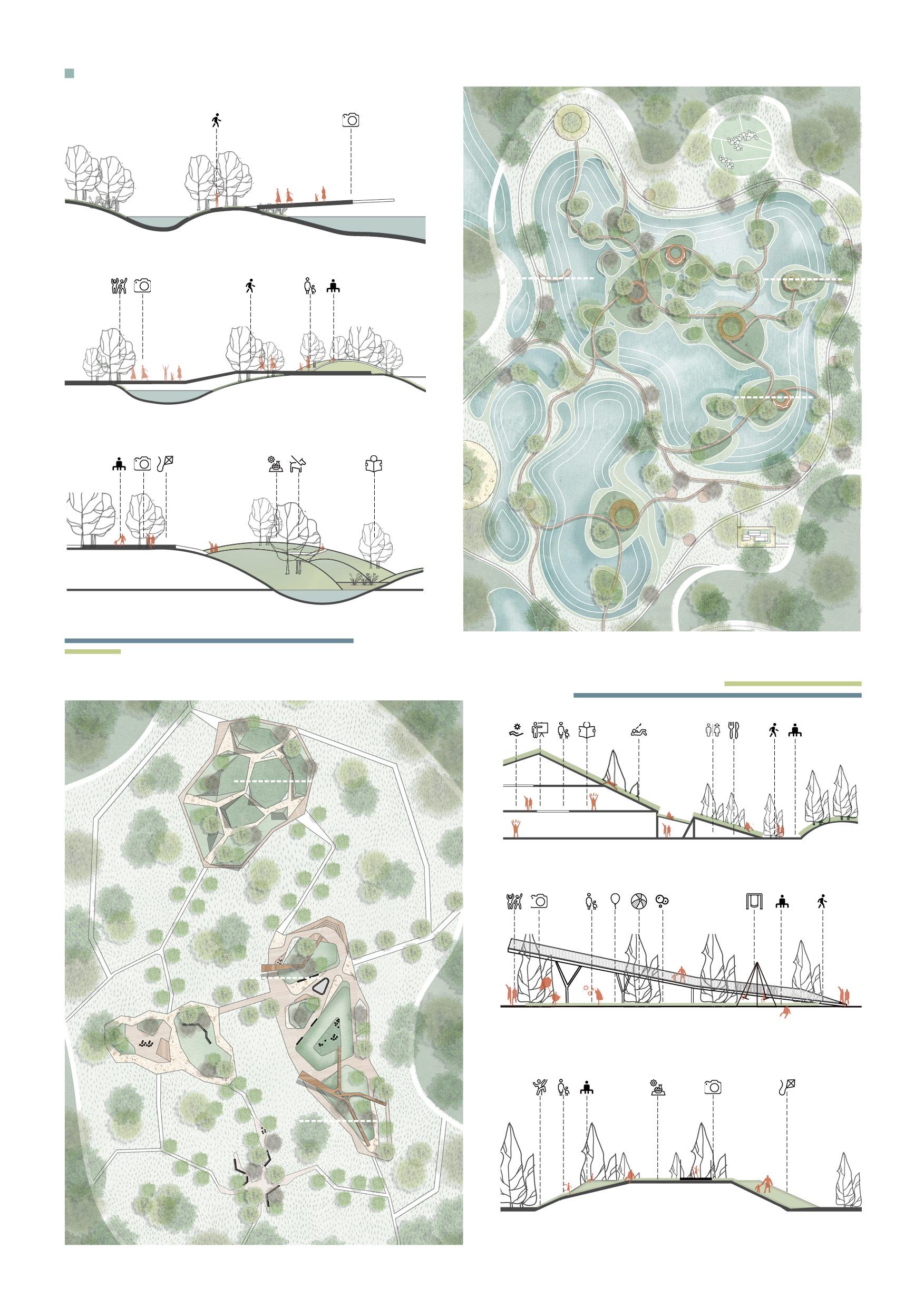
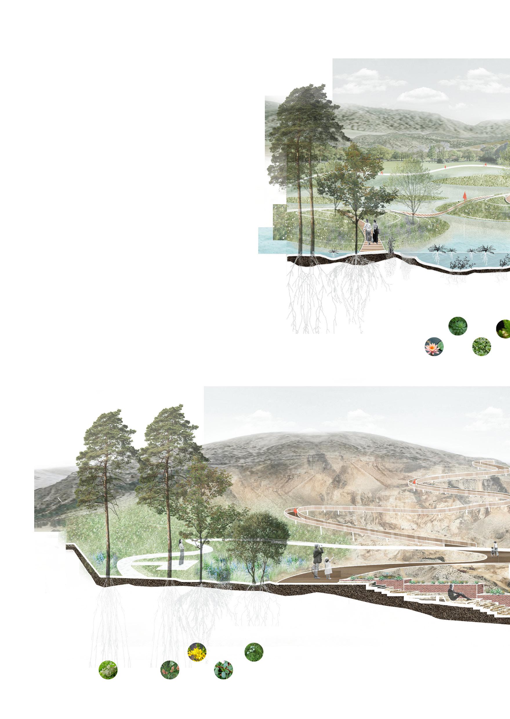
A-A Scenic Boardwalk
B-B Viewing Platform
C-C Wetland Recreation
D-D Colliery Museum
E-E Children's Sunken Theater
D B C A E F D B C A E F
F-F Climbing Area for Children
Section Perspective
Wetland Ecological Park Area
The wetland shall be constructed using Design Strategy 3 for the subsided land resulting from coal-mine with high ecological sensitivity in the site to solve the problem of water pollution caused by coal mining. The coal gangue is backfilled as soil, nourishing the growth of plants during the long natural succession. The artificial wetland park can also bring tourists a relaxed and pleasant tour experience.
The collapse area is close to the ponding revetment, and the ability to resist waterlogging and pollution should be considered when selecting the varieties of trees. Aquatic plants with high purification capacity are planted in shallow water areas to improve the quality of water areas.
10
M y r i o p h y l l u m v e r t i c i l l a t u m L . o r i e n t a l i s ( L ) F r a n c o P l a t y c l a d u s F o r s y t h i a s u s p e n s a C e r a t o p h y l l u m d e m e r s u m L N y m p h a e a t e t r a g o n a P i n u s b u n g e a n a Z u c c R o b i n i a p s e u d o a c a c i a L P o r t u l a c a o l e r a c e a L T r a p a b i s p i n o s a R o x b
Wetland Plant Configuration
Mine Pit
Climbing Plank
Waterfront Waterfront Plank
Rest Place in Forest
Mine Theme Park Area
The theme park area of the mining area is built at the mine pit and coal gangue hill in the original site. The coal gangue is reused through the coal gangue utilization method proposed in Design Strategy 1 and Design Strategy 2 . The mine pit style is presented to show the place's memory to visitors.
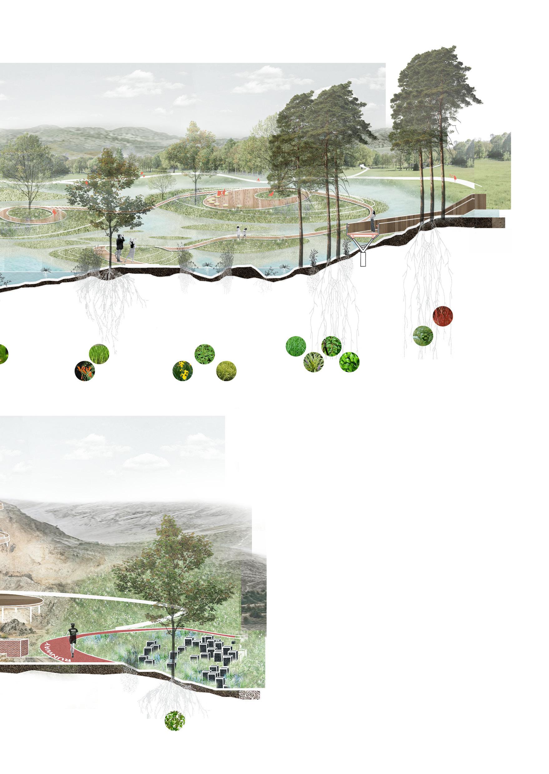
Mine Plant Configuration
Plants should choose plant varieties with tolerance to a wide range of pH values and drought and barren to improve the soil humidity and temperature conditions, establish the nutrient cycle between plants and soil, and ensure the success of the plant replantation strategy.
11
p u m i l a L . U l m u s i m b r i c a t u m ( N u t t a l l ) C r o o m T a x o d i u m d i s t i c h u m v a r . A r u n d o d o n a x L U l m u s p a r v i f o l i a J a c q B u x u s m e g i s t o p h y l l a L e v l C y n o d o n d a c t y l o n × C t r a n s v a a l e n s i s L e m n a m i n o r L O p h i o p o g o n j a p o n i c u s C o r n u s a l b a L i n n a e u s A c o r u s c a l a m u s L C a n n a i n d i c a L S c i r p u s v a l i d u s V a h l
Runway
Wetland Plants Waterfront Rest Space
Gangue reuse structure
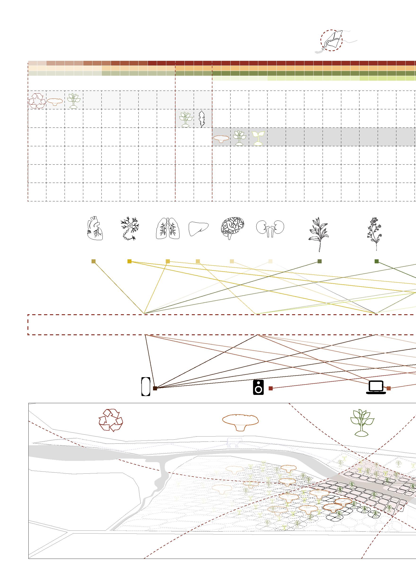
I M P O R T A N C E 12 Environment Slum & Poors Government LOW ACTIVITY DENSITY E-waste Recycling Contamination Remediation Contamination Monitoring Living HIGH ACTIVITY DENSITY
02
Inverted pyramids
A digital deisgn for a community that makes a living from e-waste
Acadamic Work
Agbogbloshie, Accra, Ghana
Individual Work
Tutor: Minzhi Lin; Jieping Chen
October 2021
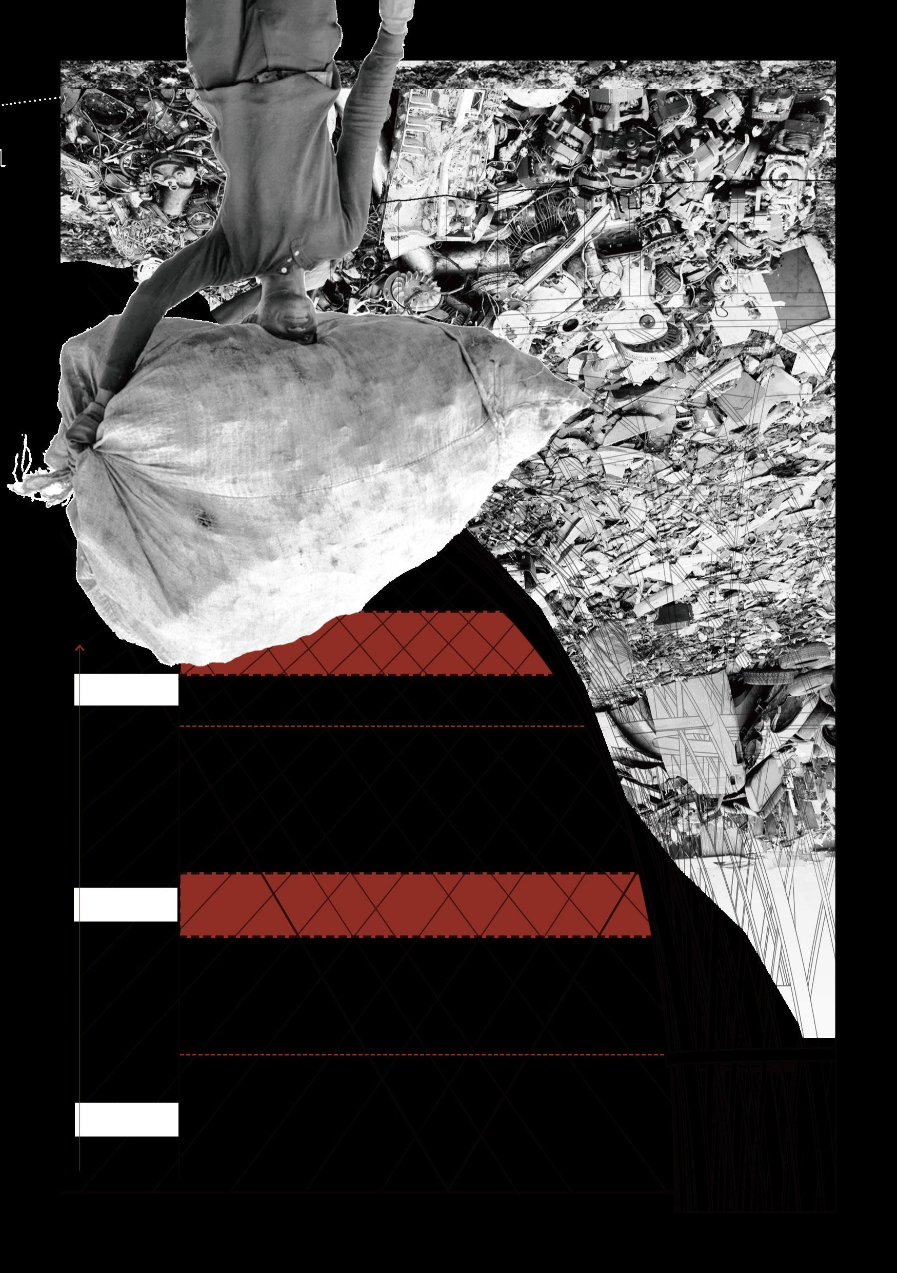
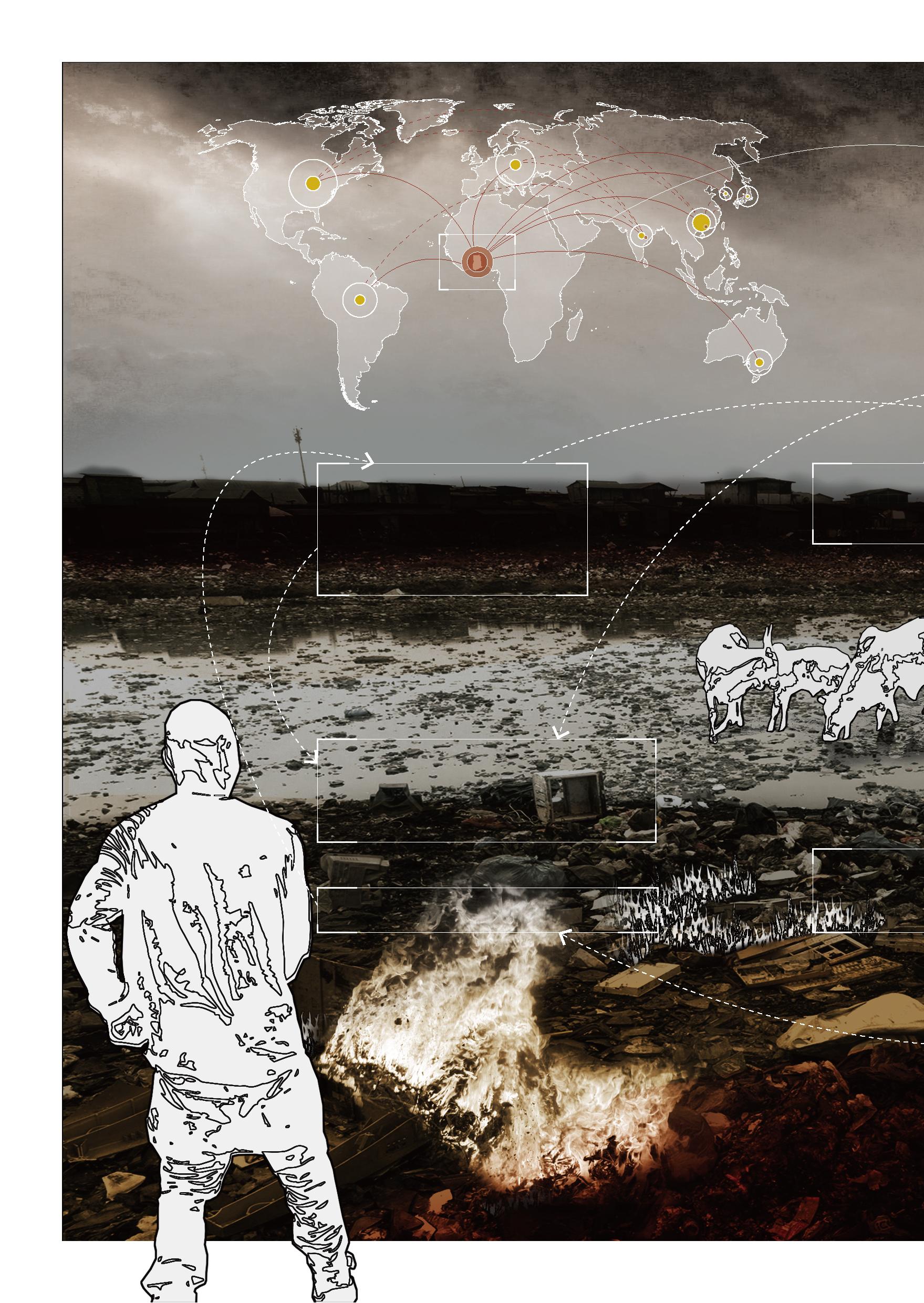
The site is controversial in the capital of Accra, Ghana; this used to be a lagoon where mangroves grew and is now a huge source of pollution. It is called "Agbogbloshie". Locals also nicknamed it "Sodom and Gomorrah," two cities condemned in the Bible. However, the poor living here believes this is a dignified land providing housing and job opportunities. Despite improper burning and dismantling, it has created devastating environmental and health problems for the entire capital. The dumping of e-waste brings them many discarded precious metals, which means a considerable income.
In 2021, the Ghanaian government incorporated it into its utopian urban planning, using it as part of the land for the construction of medical facilities, pulling out the slums on the site, and relocating the dumping site, which not only fails to fundamentally solve the pollution but completely defeat the dignity of the poor.
Based on site characteristics and unavoidable waste dumping, I use phytomining and automation to amplify its site characteristics as an e-waste disposal site and make the e-waste industry harmless while retaining its employment opportunities. At the same time, to ensure the living problem of the poor while using phytomining for soil remediation, the slum is lifted vertically in the form of a giant landscape structure, forming a utopian living form that places the poor on the upper layer. It is an ironic project that celebrates the impartiality of the landscape.
13
E-waste exported to other countries
E-waste exported to Ghana
E-waste importing countries
E-waste exporting countries
Slum: Old
PM 2.5 > 150 μg/m³ 10 times higher than The maximum limit (WHO): 15μg/m³ Mortality Rate: 80/100,000 >28,000 people/year
Daily Income: GH¢2 ( $0.35) ~ GH¢200 ( $35)
Population Structure: Young Men & Children 80% of the children have dangerous levels of lead in their blood.
Population: 40,000 Most residents work High Residential
E-waste Burning
Main cause of Air Pollution in Accra Central
Soil Pollution
Poisons such as furans, and brominated into the surrounding
14
The US 6.3/19.4 Brazil 1.5/7.4
Ghana
Germany 1.9/22.8 France 1.4/21.3 The US 6.3/19.4 India 2.0/1.5 China 7.2/5.2 Japan 2.1/16.9 EU Korea Australia Ghana 2.5 Million Metric Tonnes
Fadama
Soil Pollution Soil Pollution
Pollution End
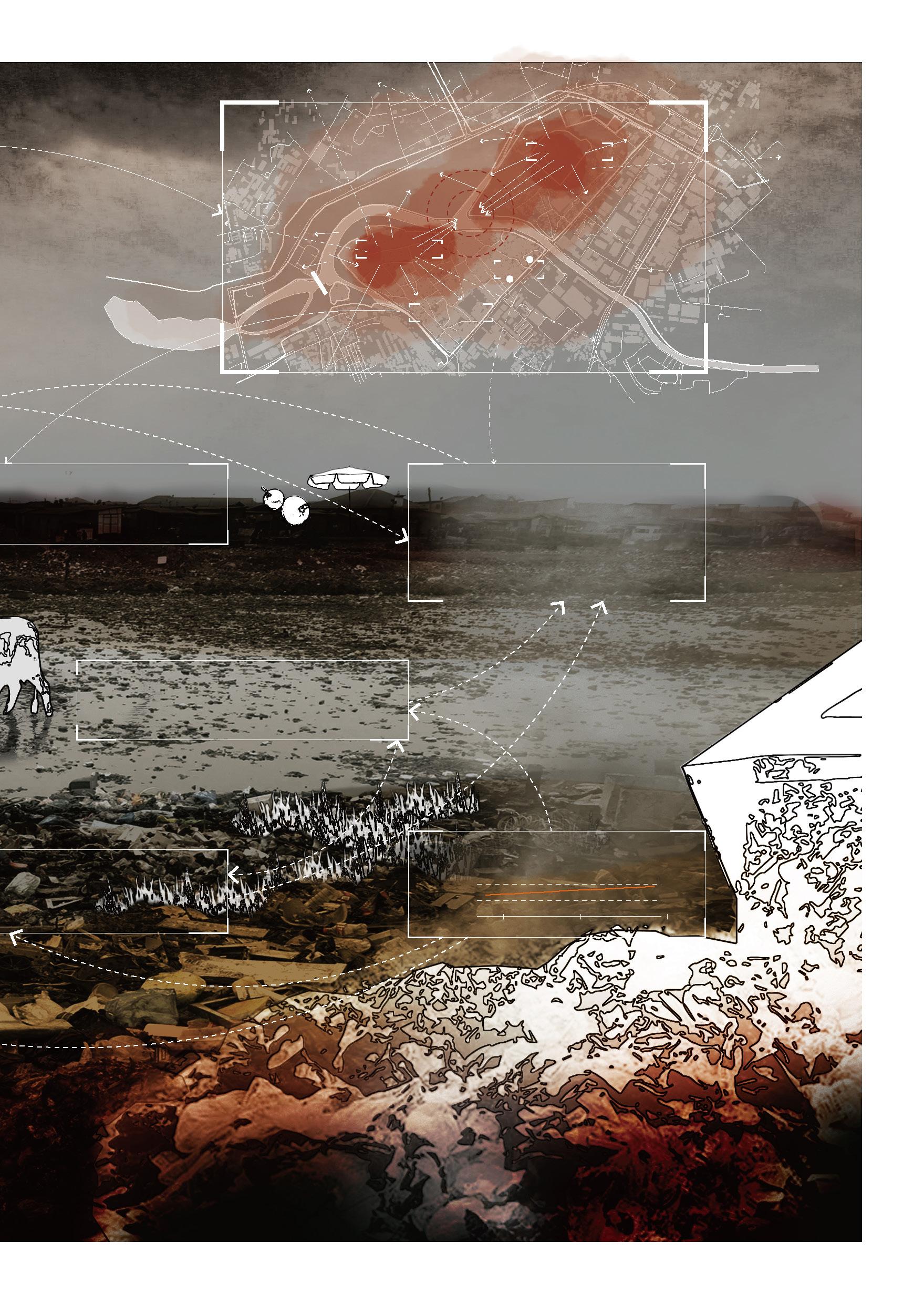
Agbogbloshie
40,000 Women, Men and Children work at Agbogbloshie Density: 0.2m²/person
Water Pollution
the Basel Action Network found dangerous levels of dioxins and PCBS in chicken eggs at Agbogbloshie.
Onion Market: 207m from the dumping site
Tomato Market: 446m from the dumping site
Largest Food Market in the Accra Central
E-waste Input: 13,090 ¬ 17,094 tonnes/year
as lead, mercury, arsenic, dioxins, brominated flame retardants seep surrounding soil.
15
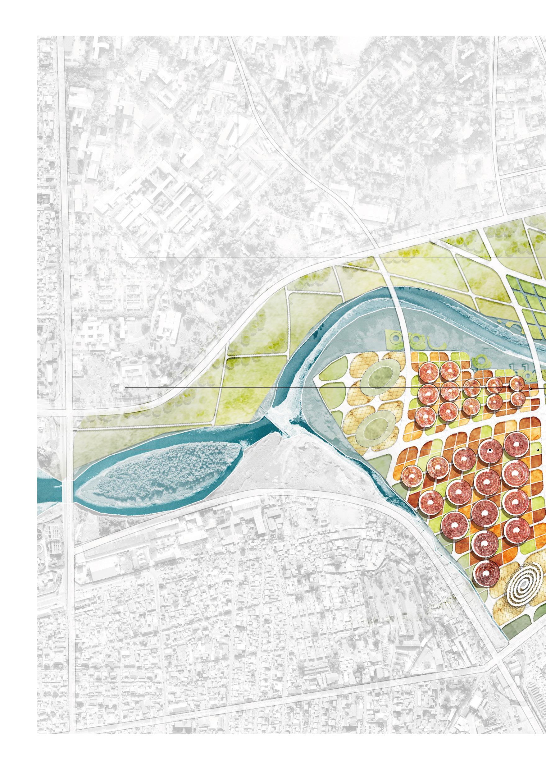
Agbogbloshie is situated on the banks of the Korle Lagoon, northwest of Accra's Central Business District.
Dumping Site
Dumping Site
Old Fadama
Fadama
Pollution
Market Market
Beginning
Metric tonnes 0 1.0 2019 2024 2030 2.0
Metal
E-waste
Health Problems
Period
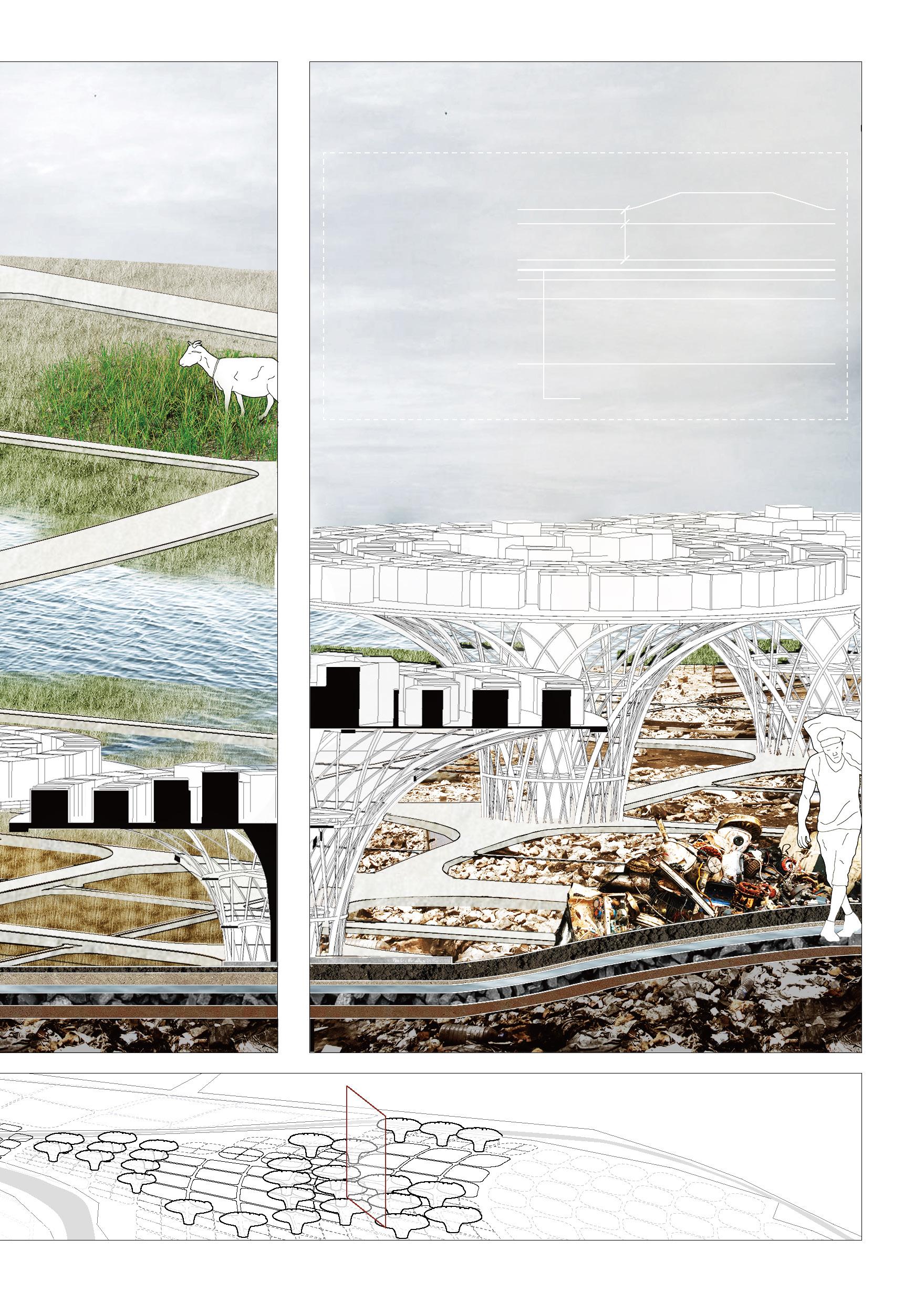
16 Industrial Construction
Period 1 5 YEARS
Elements
E-waste E-waste Recycling Living Phytomining Ni -nickel Cu -copper Pb -lead Heart Mobile Phone MP3 Computer Nervous System Lung Liver Brain Kidney Pycnandra Acuminata Crotalaria Nocae Hollandiae
Industry Density
2 8 YEARS Monitor 1 1 YEAR
Phytomining.
Agriculture.
recycling. Phytomining. Residential structure constrcution. More
More Residential structure constrcution. Join
More Agriculture. Join Stockbreeding. More Residential structure constrcution.
Period 3 5 YEARS Period 4 3 YEARS
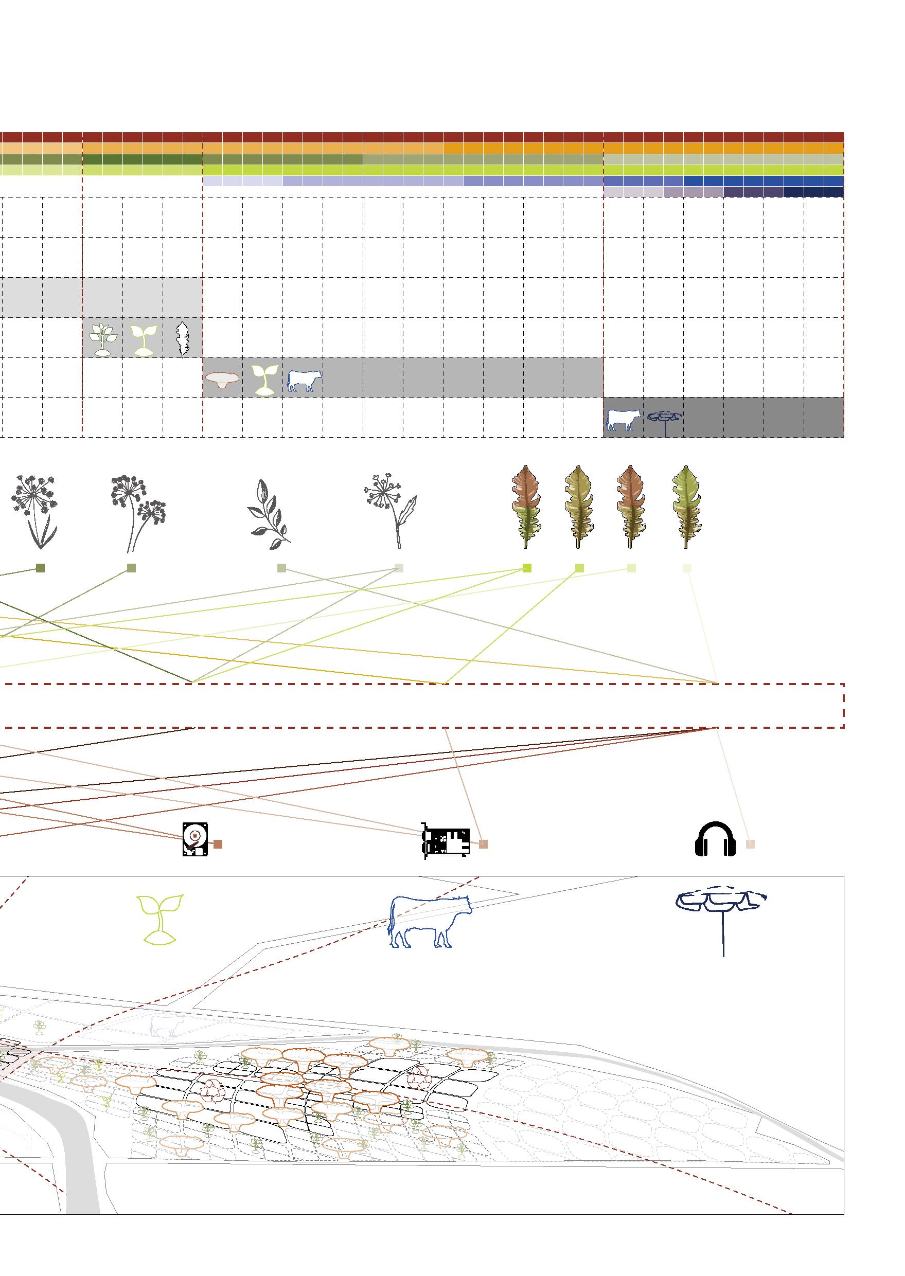
17 Construction Agriculture Stockbreeding Market Zn
Hg-mercury Co
Computer Hard Disk Drive PCB Earphone
-zinc
-cobalt
Alyssum Murale Neptunia Amplexicaulis Gossia Fragrantissima Brassica Juncea Taxiphyllum Taxrameum Hyperaccumulator Plant Indicator
Monitor 2 1.5 YEAR constrcution.
More Stockbreeding. Join Market.
Residential structure of 3 hight & connection
Reactor for e-waste recycling
End-processing
Pre-processing
3 types of public structure
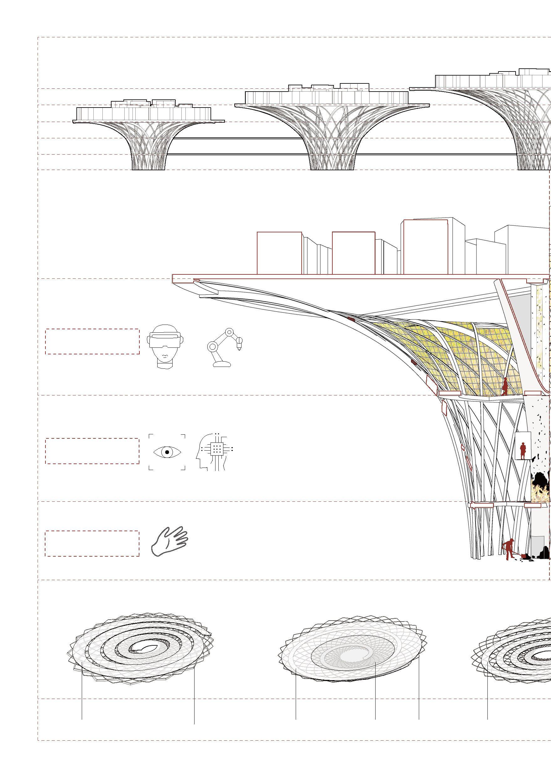
WORK
Analysis of bulk powder
Processing of bulk powder
Convert to raw meterials
TECHNOLOGY
Auhmented Reality
Energy Efficient Robotics
WORK
Device disassembly
Device shredding
Sorting into e-waste fractions
Grinding into bulk powder
WORK TECHNOLOGY
Machine Vision
Machine Learning & Artificial Intelligence
E-waste collection
Device level sorting
WAGE
£7.83 / hour in the UK
£1.29 / hour in Agbogbloshie
18
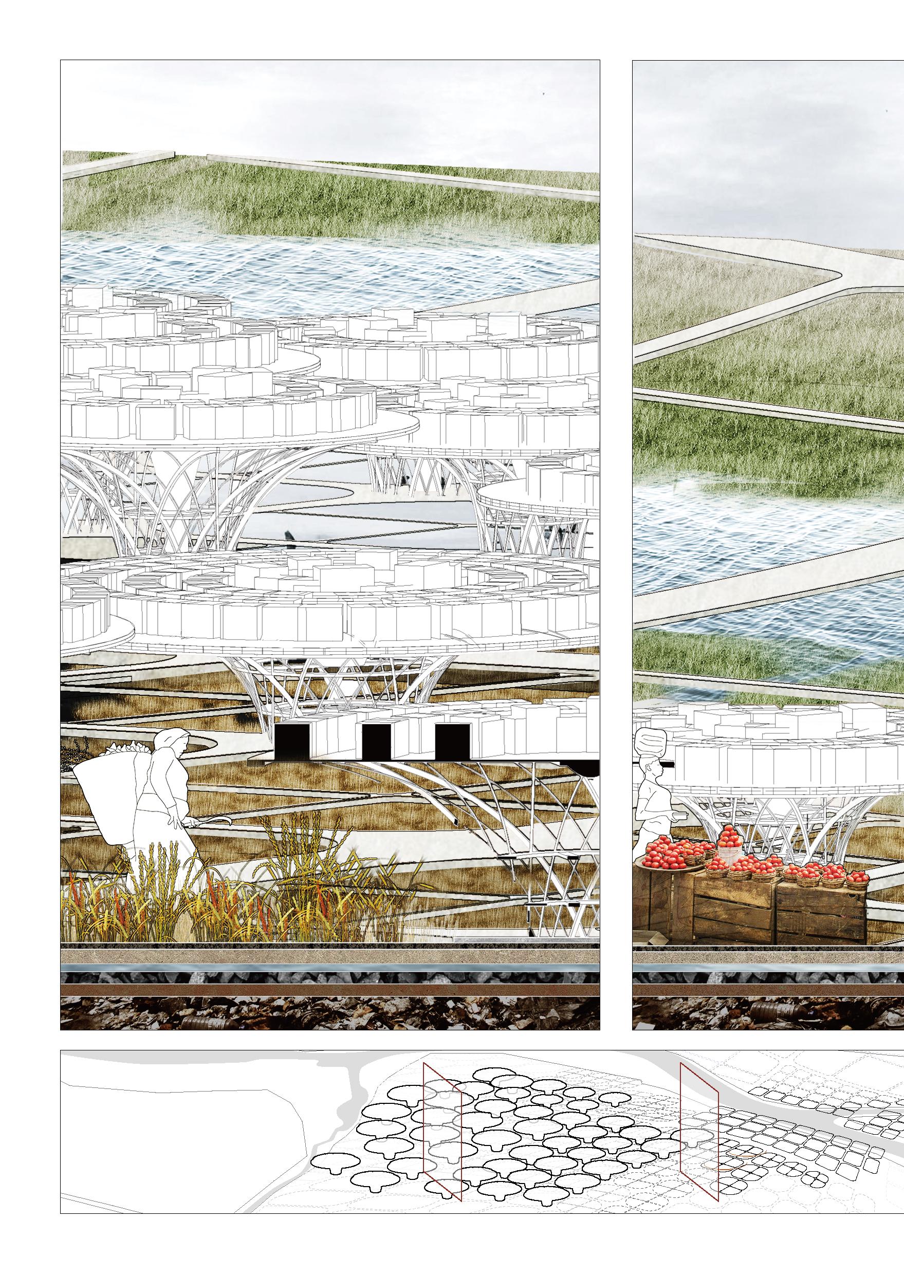
20m 16m 12m 12m 16m 20m 8m 4m 0
Market Platform: 8m wide Structure Boardwalk:
Structure
Football
3m wide
Boardwalk: 5m wide
field Football Field Music Piazza
Collection
Modelling by Grasshopper
Reactor for phytomining
The ash is mixed with water and electrolysis is then used to extract the metal from the mixture.
Hyperaccumulators are delivered into the second layer of the reaction for incineration.
The ash is then delivered to the third layer of the reaction.
Hyperaccumulators are grown in an area with high grade ores
Hyperaccumulators are harvested and transported into the bottom layer of the reaction by the poor.
Modelling by Grasshopper
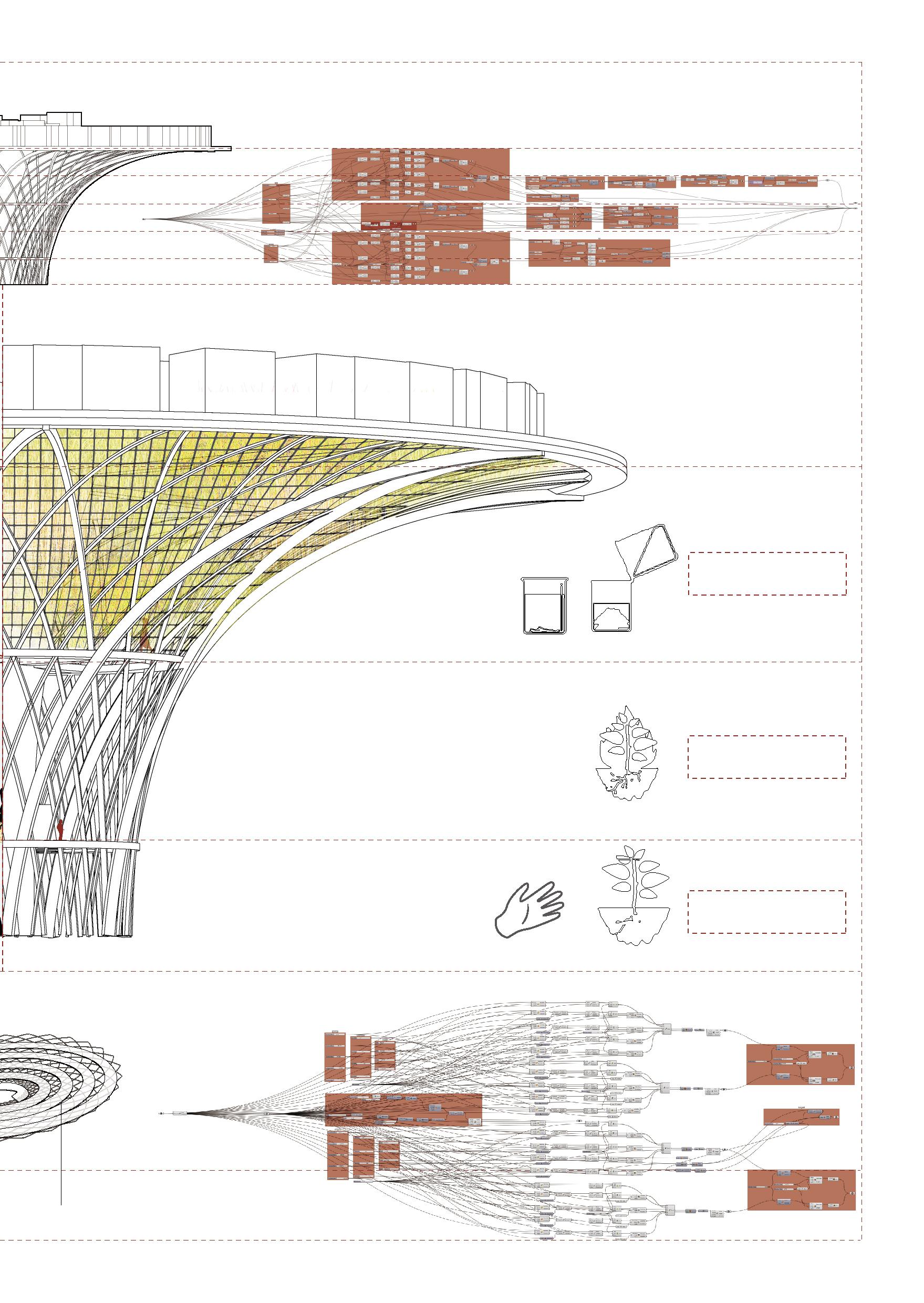
hydrolysis
Incineration
Planting
19
20m
Structure Piazza
Master Plan
Community1 >690 people
Community1 >690 people
Community2: >2083 people
Community3: >1017 people
Mangrove
KorleLagoon
Community4 >1576 people
Tuesday Market Football Park
Timber Market
G u g g i s b e r g A v e 20
Ring Rd W Rd
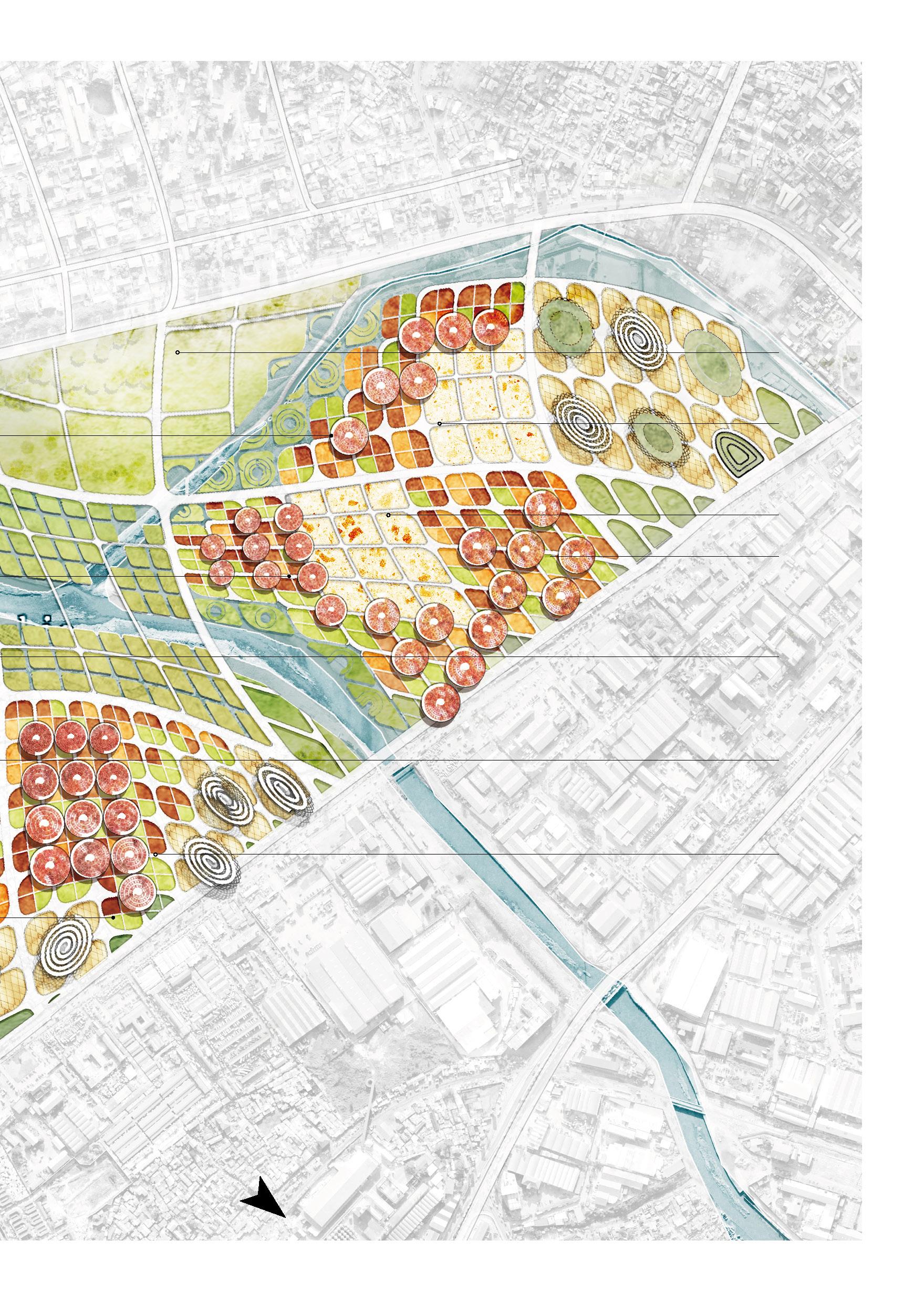
21 242863.63 m² Stockfeeding 28234.98 m² E-wate Recycling 847656.40 m² E-watse Recycling 33644.70 m² Phytomining 39037.02 m² Agriculture 85455.32 m² Agriculture 61566.25 m² Agriculture 0 50 100 200 500 Meter N
GraphicRd
Agbogbloshie Market
Abossey Okai Central Mosque
22
Position of perspectives Perspective 1 Perspective 2 Perspective 1 Phytomining & Agriculture Perspective 2 Stockfeeding & Market
Perspectives
23
3
Perspective
Recycling A Landscape Cap Barrier Protection Meterial 6 in min 2 ft min Planting Soil Drainage Layer Gas Vent Layer Soil Barrier Layer Waste Impermeable Plastic Liner
Perspective 3 E-waste
Current flood divection
Original flood divection
Flood area
Current river courses & Reservoir
Current flood divection
Agricultural losses
Original river courses
Original flood divection
Safety loss of life and property
Loss of biodiversity
Floodplain
24
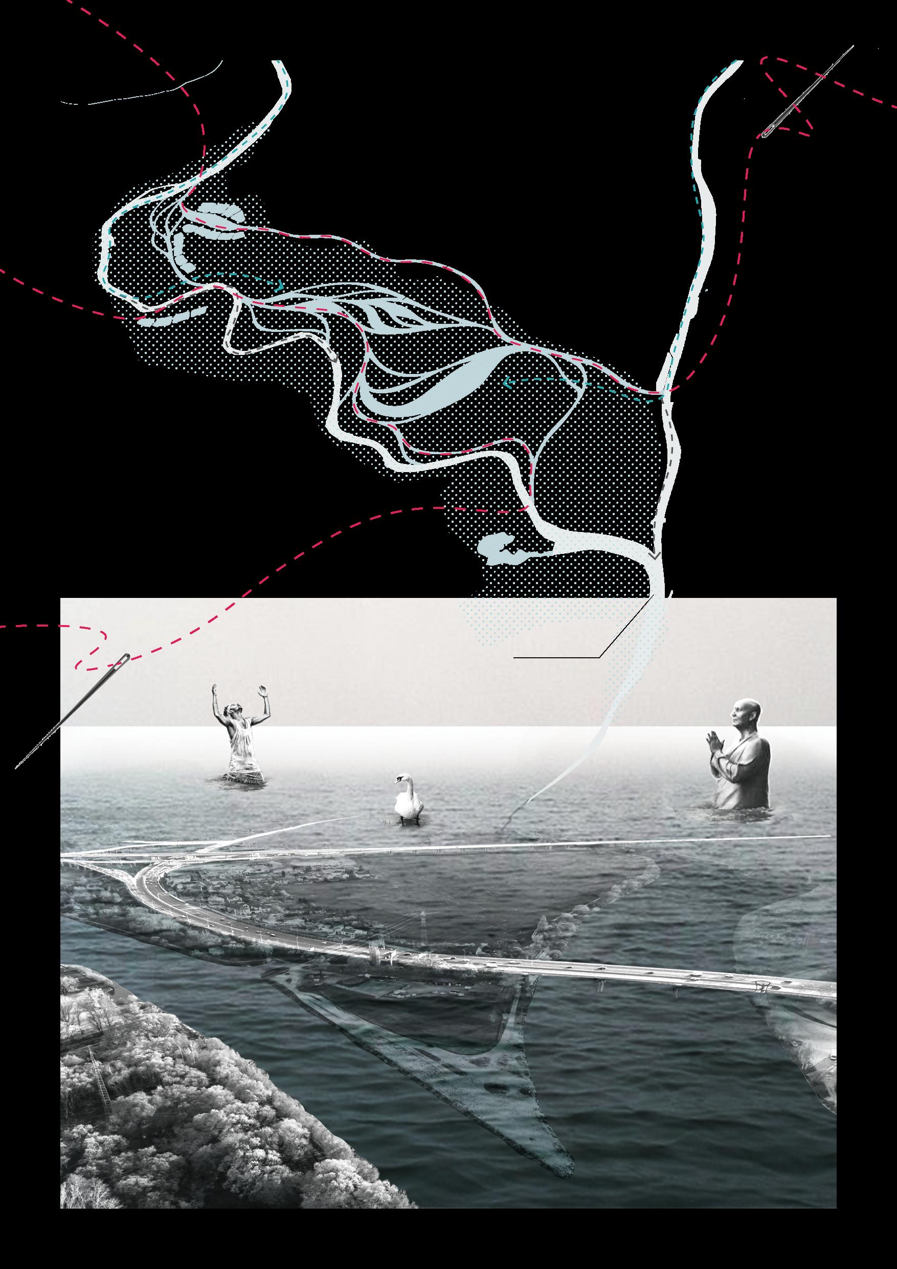
Vltava River
Benounka River
03
Weaving rivers
A resilient landscape design oriented by flood adaptability
Acadamic Work
Prague, The Czech Republic
Individual Work
Tutor: Pang Li
December 2022
The project is located in the floodplain at the confluence of the Vltava River and Benounka River on the outskirts of Prague. Since the floodplain is located upstream of the Vltava river flowing through Prague, it is of great locational significance for preventing or delaying floodwaters from entering the center of Prague.
Due to the wrong river management in recent years, the historical river course has been artificially filled or shortened and straightened. Although the historic confluence of the Benounka river and Vltava river and other historic waterways are still visible and forced to be used during floods, they still cannot regulate or slow down the surge of river flow during heavy rains in any way.
The planning goal of this project is to realize the resilience of the landscape, and the design strategies of flood resilience, economic resilience, and biodiversity resilience were put forward, and then the flood-adaptive design of suburban parks was carried out. Through diverse water landscape designs, the Vltava river and Benounka river were woven together to relieve the pressure of floods on a single waterway.
25
Problem Analysis
Flood risk
Insuffient flood-adaptive facilities Artificial flood control facilities that weaken the river's flood discharge capacity
The floodplain Çernošice, and excellent opportunity the development
Construction of multi-level road system
Activities and temporary installation heavily dependent on the transportation system
Average
Landscape infrastructure construction
Insufficient landscape infrastructure such as seats that can not meet the needs of high-density crowds
Addition of sports facilities
Inseffitcent sports facilities construction that does not match sports demand
Diversified habitat construction
Insufficient vegetation configuration that can adapt to the floodplain habitat Single vegetation type & chaotic plant configuration
Černošice
7,925 inhabitants
Average age 38.8
26
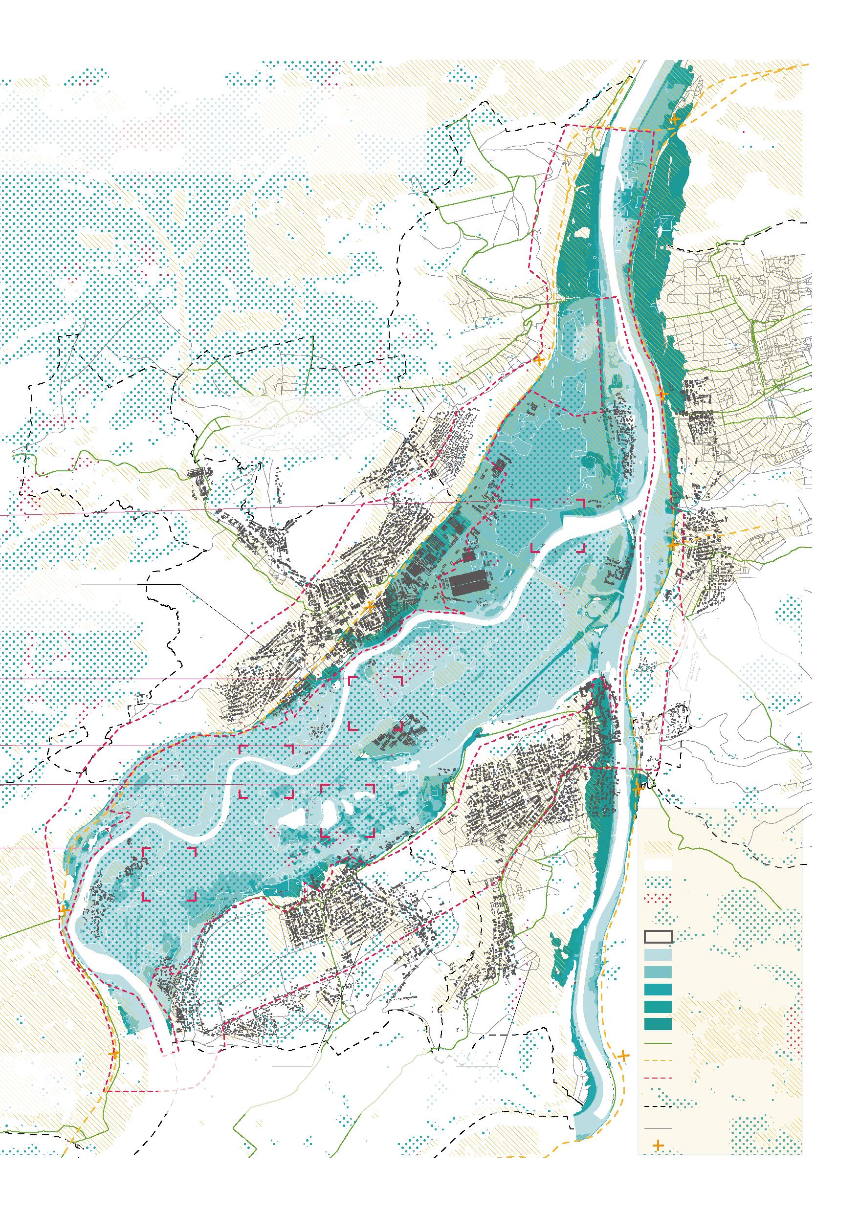
floodplain area spans five Prague city districts and a Central Bohemian town, and covers an area of approximately 1300 hectares. This presents an opportunity for the development of recreational, sustainable farming and development of valuable river views.
14,234 inhabitants
Average age 39.2 years old
836 inhabitants
Average age 39.2 years old
12,334 inhabitants
Average age 39.2 years old
Legend
Settlement
Water Body
Agriculture
Bare Land /Brownfield
Buildings
Q5 Flood Area
Q20 Flood Area
Q50 Flood Area
Q100 Flood Area
Floodplain Area
Cycling Road
Railway Design Area & Area of Interest
City Districts
Road
Railway Station
27
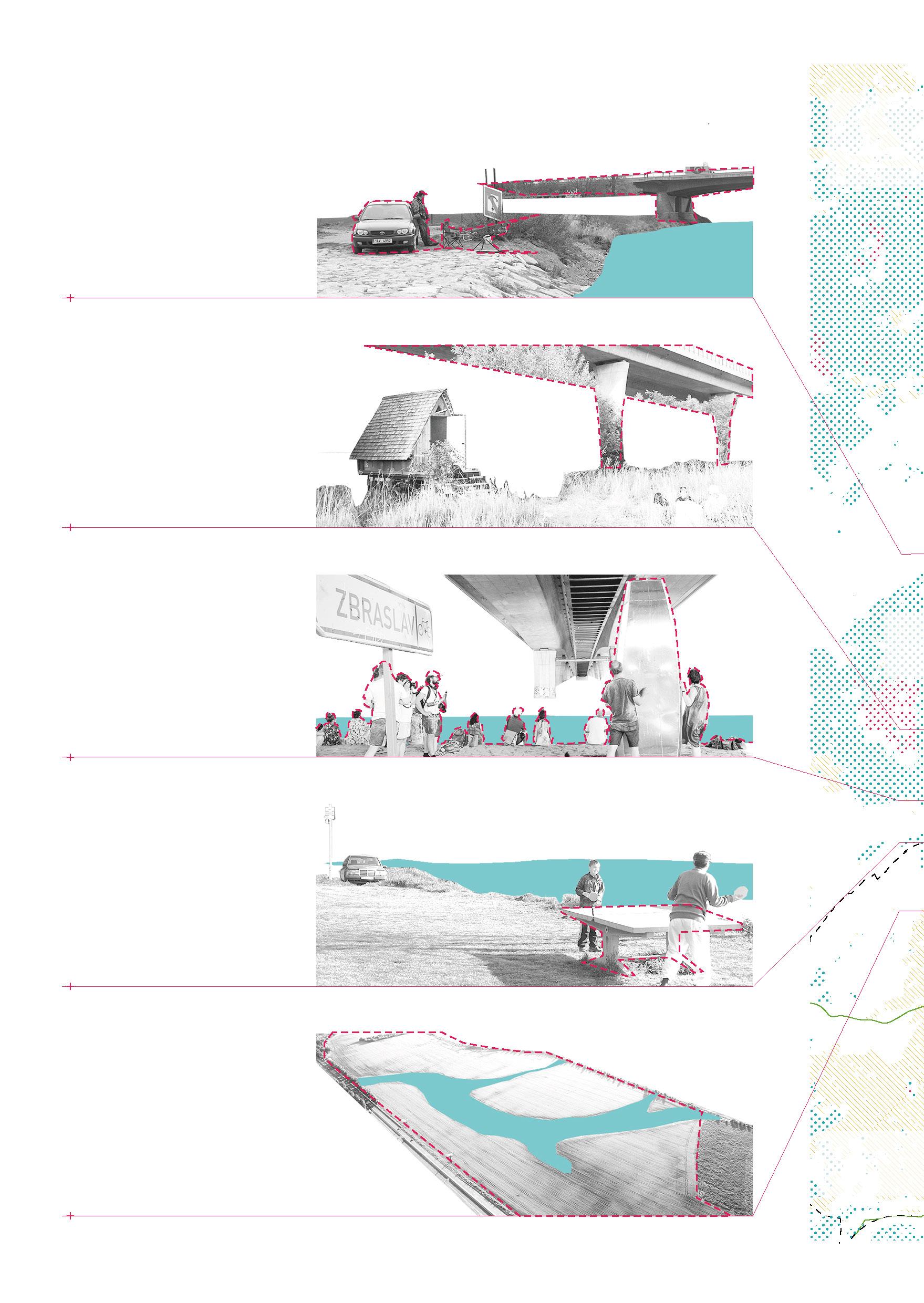
Černošice Lipence Zbraslav
Lahovice Radotín
Modřany
inhabitants 38.8 years old 3,564 inhabitants Average age 40.5 years old 12,693 inhabitants Average age 39.2 years old
28
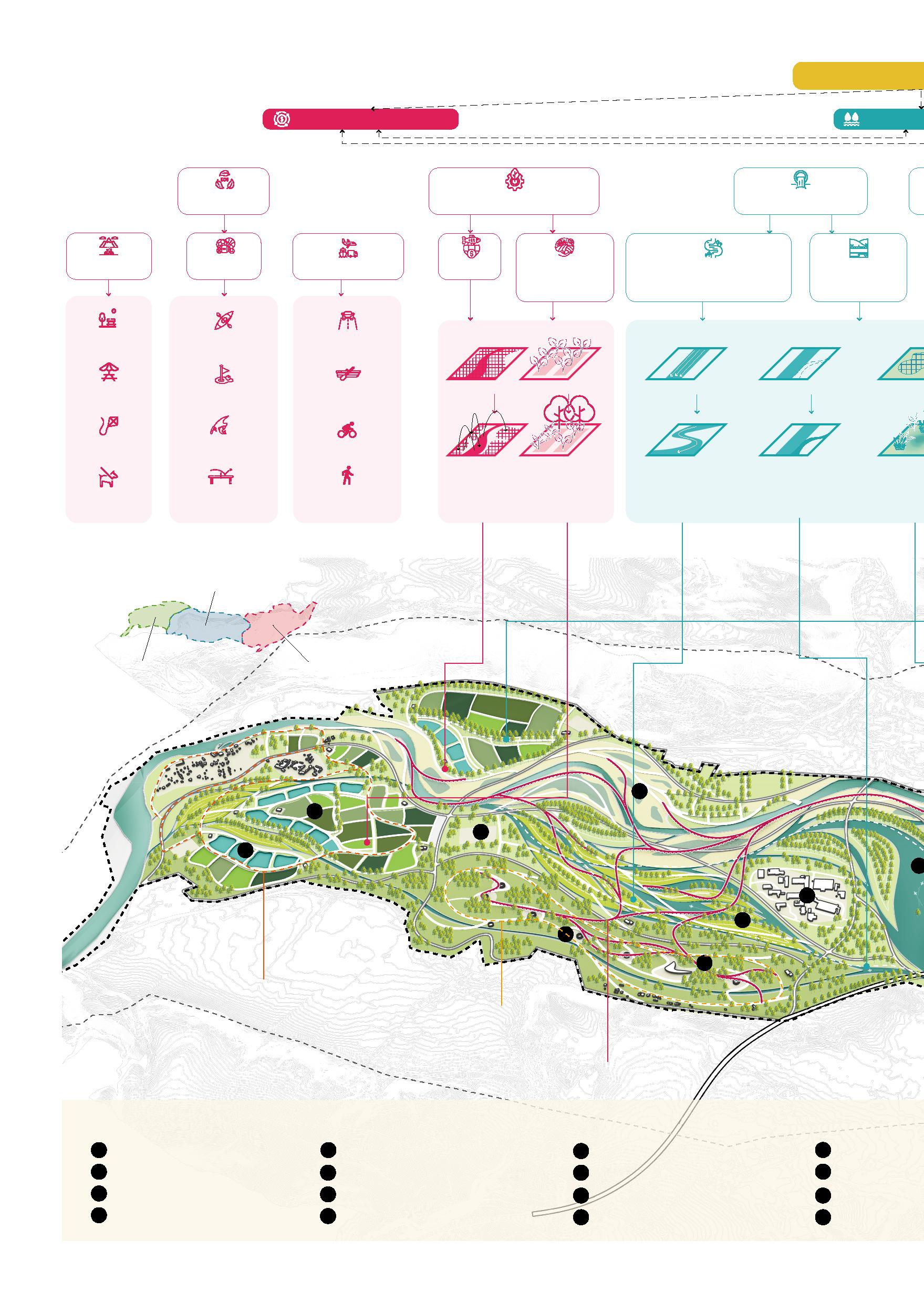
Flood Resilience Economic Resilience Eco-tourism
Sports Transportation Fishery Sustainable Agriculture Revert the watercourses to curves Reuse historic waterways Store & Flood Historical Watercourse Slow Down the Flow Fishponds Sidewalk Table Tennis City Park Landscape Bird-watching walking route Boating
Water Landscape City Park Landscape Agriculture Landscape Waterfront plank road Boating park Benounka & Vltava river Shrubbery Wedding building Wetland plank road Sports park Golf course Flower field City park Kiting & picnic lawn Kayaking club Yoga park Dry fountain Natural lawn Lake for kayaking Walk Dog Cycling Track Sport Fishing Fly Kite Waterway Golf Picnic Roadway Kayaking Bench Food Forest Sustainable Industry Flood Drainage 1 5 9 10 14 13 11 15 12 16 2 6 3 7 4 8
Landscape
Recreation
Ecological
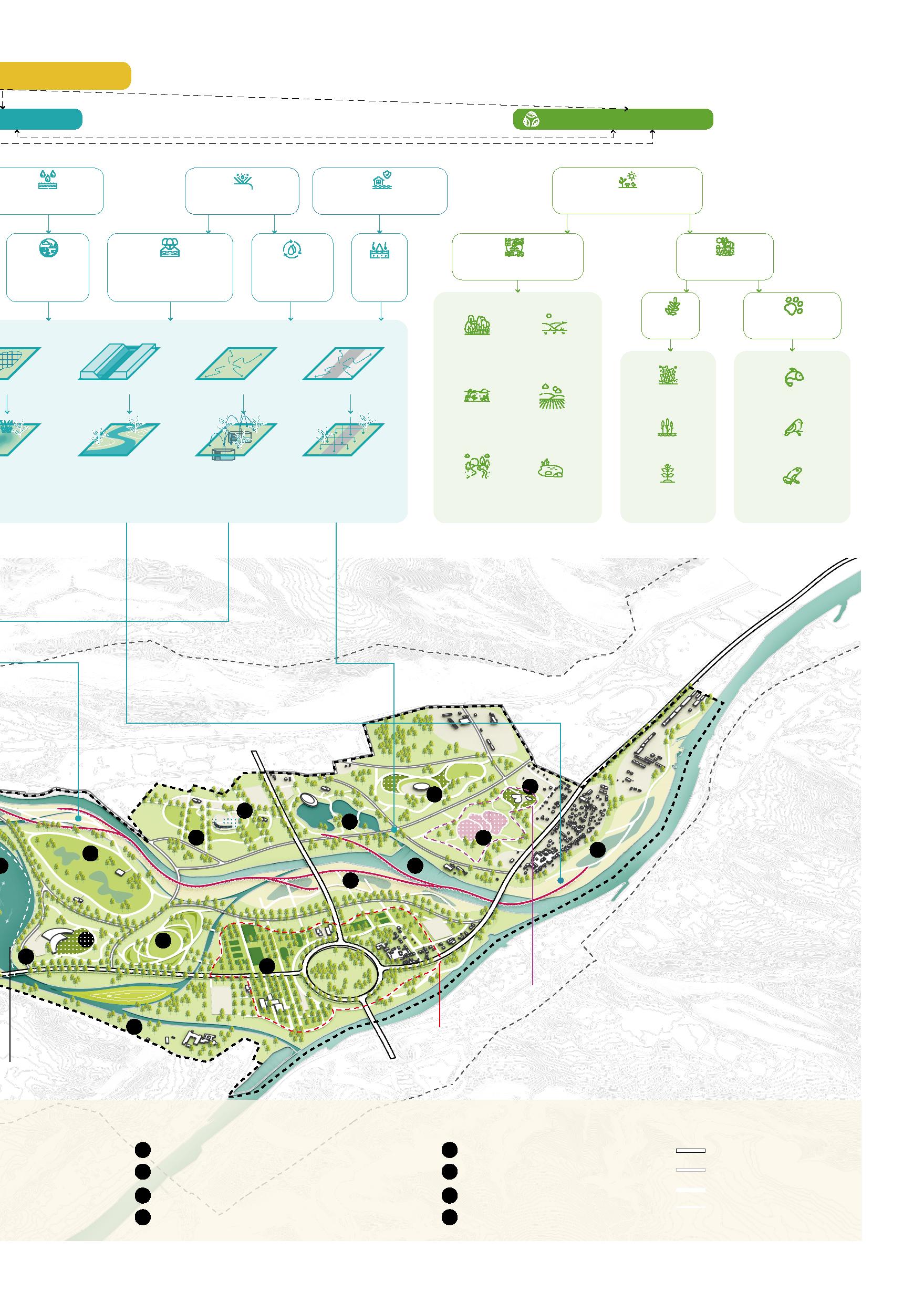
29 Resilience Resilience Ecological Resilience Construct wetlands Build ecological berms Reuse rainwater Absorb water Habitat Diversity Biodiversity Plant Animal Aquatic Animal Hydrophyte Forest Grassland Wetland Fields Creek Permeable Paving Surface Irrigation Replace Flood Wall & Purify Flood Boating route Sports route Hanada wedding route Residential area Bird watching tower Highway Biological observation wetland park Parking lot Main Road Forest park Agriculture picking park Road kayaking Wetland park Fish pond Path Fishponds Bird Macrophyte Amphibian Terrestrial Plant Flood Storage Flood Control Flood Adaptation Ecosystem Diversity 18 22 17 21 19 23 20 24
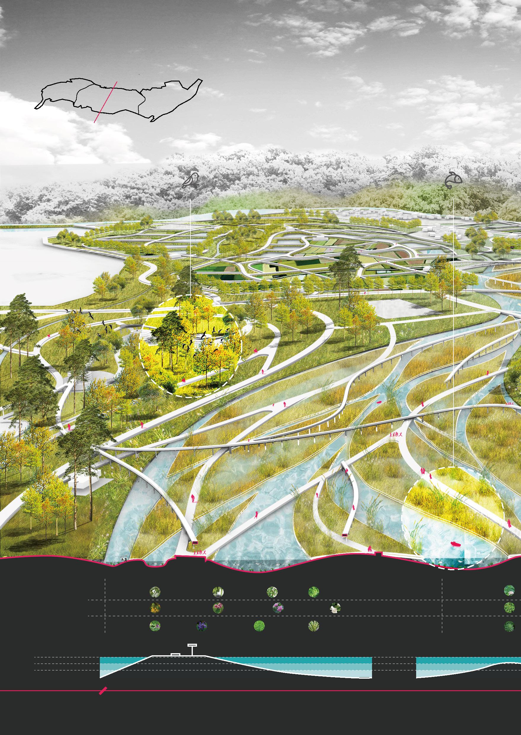
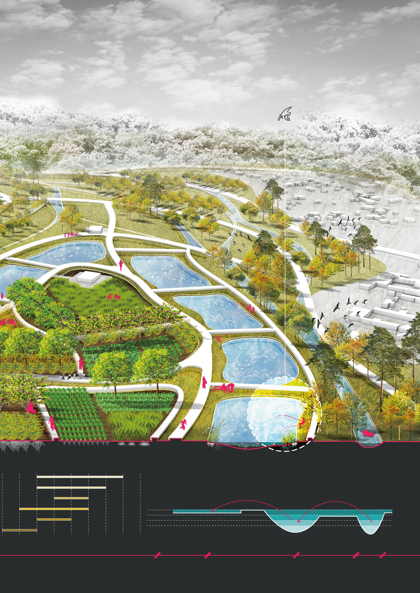
Sectional Perspective of Ecological Water Landscape
30
Biodiversity Arbor Emergent Plants Populus
Salix
Ulmus
Nelumbo Lemna Myriophyllum verticillatum
Gardenia
Medicago
Cyperaceae Shrub Floating Plants Herb Q100 Forest Wetland Q5 Normal Level Submerged Plants Flood Tolerance Bird
Tourist
Forest Wetland
tomentosa Carr
babylonica L.
pumila L. Metasequoia glyptostroboides Hu & W. C. Cheng
Forsythia viridissima Lindl. Lagerstroemia indica L. Hibiscus syriacus Linn.
jasminoides Ellis
sativa L. Iris tectorum Maxim. Ophiopogon japonicus (Linn. f.) Ker-Gawl.
Watching
Boating & Fish Observing
31
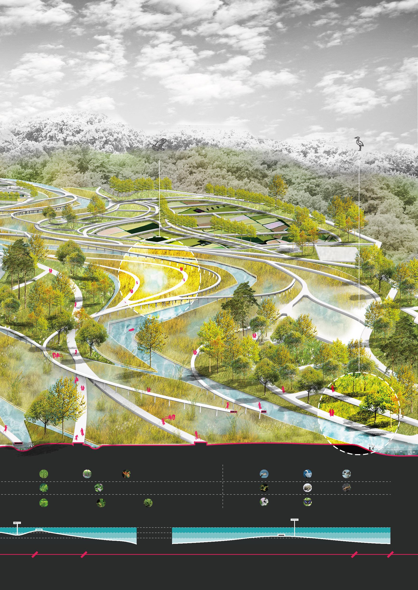
Bird
Nelumbo sp. Scirpus validus Vahl Lythrum salicaria L. Canna indica L.
Snow goose Mute swan Green-winged teal
Pool frog Green Toad Carpathian Newt
Parnassius apollo Purple Emperor Butterfly
Lemna minor L. Potamogeton distinctus A.Benn. Eichhornia crassipes (Mart.) Solms
Myriophyllum verticillatum L. Hydrilla verticillata (Linn. f.) Royle Ceratophyllum demersum L. Vallisneria natans (Lour.) Hara
Amphibian
Wetland
Insect
Amphibians Observing
Waterfowl Observing
Forest Wetland River
Sectional Perspective of Agriculture Landscape
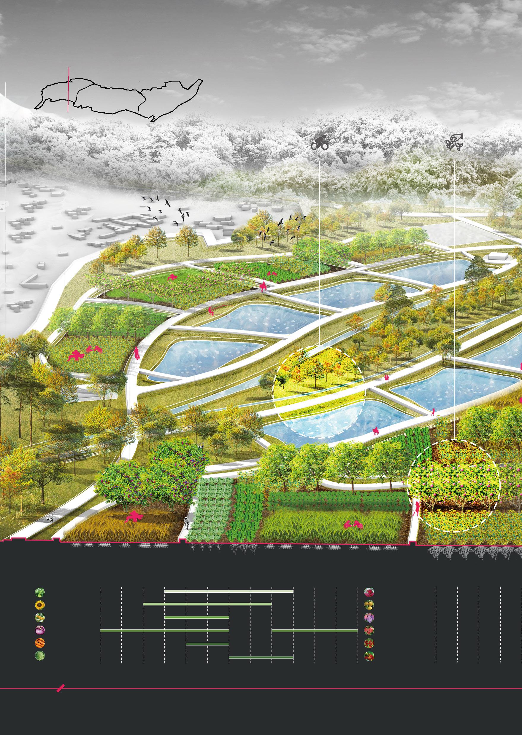
32
Picking activity intensity & Rotation period Rape Cycling Picking Jan Forest Field Apr July Oct Feb May Aug Nov Mar June Sept Dec Jan Apr Feb Mar Apple Sunflower seed Pear Corn Prunus domestica Onion Peach Carrot Currant Cabbage Cherry
When there is a flood, the fish pond can be used as a flood storage tank to slow down the damage to the farmland caused by the flood.
33
activity intensity & Rotation period
Picking
Meadow
Meadow
July Oct May Aug Nov June Sept Dec Q100 Q50 Q5 Normal Level
Fishing
Fish Ponds
River Forest

