A landscape-led approach to housing the nation
landscapeinstitute.org Spring 2024 £15.00
living:
Landscapes for


Products: Solid Skirt Benches & Solitude Benches Project: Kings Cross Gasholders, London (UK) by Townshend Landscape Architects enquiriesUK@streetlife.com I www.streetlife.com I t. +44 (0) 20 30 20 1509 I FSC® license number: C105477 Extraordinary for Landscape Architects
beam size: 7 x 7 cm -certified hardwood or Accoya
and armrests
Big Green Bench
Grey (recyclate) Green Circular Skirt Benches Solid Wing Bench Cloudy Grey (recyclate) TWIN NEW Green Screen System with cantilevered Rough&Ready Benches TWIN NEW NEW
Product Range: Solid Series,
Back-
Drifter
Lava
PUBLISHER
Darkhorse Design Ltd
T (0)20 7323 1931
darkhorsedesign.co.uk
tim@darkhorsedesign.co.uk
EDITORIAL ADVISORY PANEL
Saira Ali, Team Leader, Landscape, Design and Conservation, City of Bradford Metropolitan District Council
Stella Bland, Head of Communications, LDA Design
Marc Tomes CMLI, Director, Allen Scott
Landscape Architecture
Sandeep Menon, Landscape Architect and University tutor, Manchester Metropolitan University
Peter Sheard CMLI, Landscape Architect
Jaideep Warya CMLI, Landscape Architect, Allies and Morrison
Jane Findlay, PPLI, Director FIRA Landscape Architects
LANDSCAPE INSTITUTE
Editor: Paul Lincoln
Copy Editor: Jill White
Proof Reader: Johanna Robinson
PR & Communications Manager:
Josh Cunningham
President-elect: Carolin Göhler
CEO: Rob Hughes
Head of Marketing, Communications and Events: Neelam Sheemar
Landscapeinstitute.org
@talklandscape landscapeinstitute landscapeinstituteUK
An election about housing must include a debate about landscape
Housing is set to be one of the key issues in the general election due at the end of this year. Election rhetoric often focuses on promises to build a million homes in one parliament or fears about damaging the green belt. This edition of the journal offers a more nuanced focus which highlights the creative relationship between landscape architect and architect, and the role of the public sector client.
We open with the nature-led regeneration of Thamesmead by Peabody, and conclude with an interview with Saira Ali, landscape team leader at Bradford City Council and winner of the 2023 LI President’s Award. The value of the public sector commission continues with a look at landscape-led urbanism in public housing and a reimagined almshouse, Appleby Blue, which shows how good landscape design is beneficial at every stage in a life.
We examine the rebirth of a housing estate in Barrow-in-Furness and consider how allotments are struggling for space alongside housing. We pay tribute to the legacy of Mies van der Rohe; investigate the power of the pocket park; look at the dreams of self-build pioneer Walter Segal; and consider how to safeguard a sense of place in new developments.
The focus on post-election promises considers the delivery of garden cities and the expanded research section looks at maintenance, water resilience, cohousing and how to retrofit an urban forest.
As I retire as editor of the Journal, I want to offer my huge thanks to the
many members and supporters of the LI who have been not just readers but also writers. I want to thank the Editorial Advisory Panel which has offered guidance and support throughout my time at the LI, and I want to thank Jill White who has been both a member of the EAP and for many years, copy editor. Darkhorse Design have published the Journal over the past twelve years. There is a creative dialogue between landscape design and graphic design celebrated by the catalogue of front covers illustrated overleaf, all of which can be enjoyed in detail through the online archive.
Paul Lincoln
 Editor
WELCOME Landscape is printed on paper sourced from EMAS (Environmental Management and Audit Scheme) certified manufacturers to ensure responsible printing. The views expressed in this journal are those of the contributors and advertisers and not necessarily those of the Landscape Institute, Darkhorse or the Editorial Advisory Panel. While every effort has been made to check the accuracy and validity of the information given in this publication, neither the Institute nor the Publisher accept any responsibility for the subsequent use of this information, for any errors or omissions that it may contain, or for any misunderstandings arising from it. Landscape is the official journal of the Landscape Institute, ISSN: 1742–2914 © 2024 Landscape Institute. Landscape is published four times a year by Darkhorse Design. Cover image: The Garden Court at Appleby Blue, London. © Philip Vile
Landscape is available to members both online and in print. If you want to receive a print version, please register your interest online at: my.landscapeinstitute.org
or online? 3
Print


Contents 4 6 A 12-year partnership Explore the Landscape online archive 16 Lafayette Park, Detroit The legacy of Mies van der Rohe and Alfred Caldwell 27 Modern Hospice Design A landscape architect response 35 Allotments and food strategies How food growing competes with the demand for housing 8 Brutalism and biodiversity The landscape-led regeneration of Thamesmead 20 Housing, health and landscape Appleby Blue – reimagining the almshouse for the 21st century 29 Barrow-in-Furness The benefits of retrofitting the landscape 37 Home Sweet Home Safeguarding the sense of place in new developments 13 A new era for public housing New thinking in council-led schemes 24 Courtyard and garden The landscapes of palliative care 32 Plan the street as well as the sky How to respond to a tall building at the foot of the tower 40 Home Truths Ten years on from England’s first zero carbon estate
42
45
48
51
53
56
59
62
64

73


FEATURES
The power of the pocket park The threat to Crabtree Fields
The Sayes Court Project Community development by the river in Deptford
pioneer in a challenging landscape
Walter Segal Self-build
Climate advice Focus on housing schemes
Post-election
Ensuring that housing is part of the election debate RESEARCH
promises
Finding
Water resilience Maintenance matters
landscapes of cohousing Designing resilience into housing developments How not to deprive people of the benefits of GI TECHNICAL
Getting SuDS right The impact of making SuDS mandatory LI LIFE
Saira Ali interview Meet the winner of the President’s Award
common ground
The
67
70
CAMPUS: Learn from anywhere RESEARCH
Building
Retrofitting
into social housing 5
the urban forest
urban forests
Celebrating a 12-year partnership between graphic design and landscape design
2024 marks the 12th year that Landscape, which has been in print since 1934, has been designed and published by Darkhorse Design. The back catalogue is available to download free of charge from issuu.com/landscape-institute.


FEATURE
September 2012 March 2013 June 2013 September 2014 December 2015 March 2016 June 2016 September 2016 December 2016 December 2014 March 2015 June 2015 September 2015 September 2013 December 2013 March 2014 June 2014 6


FEATURE March 2017 September 2018 January 2020 April 2021 July 2021 October 2021 February 2022 July 2022 November 2022 March 2023 June 2023 September 2023 January 2024 March 2020 July 2020 October 2020 January 2021 January 2019 April 2019 August 2019 November 2019 June 2017 September 2017 September 2017 May 2018 7
Brutalism and biodiversity
FEATURE
8

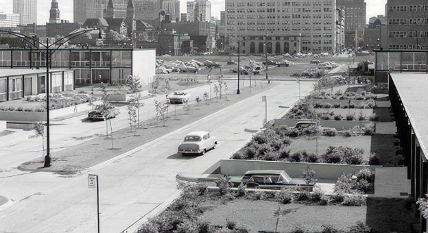
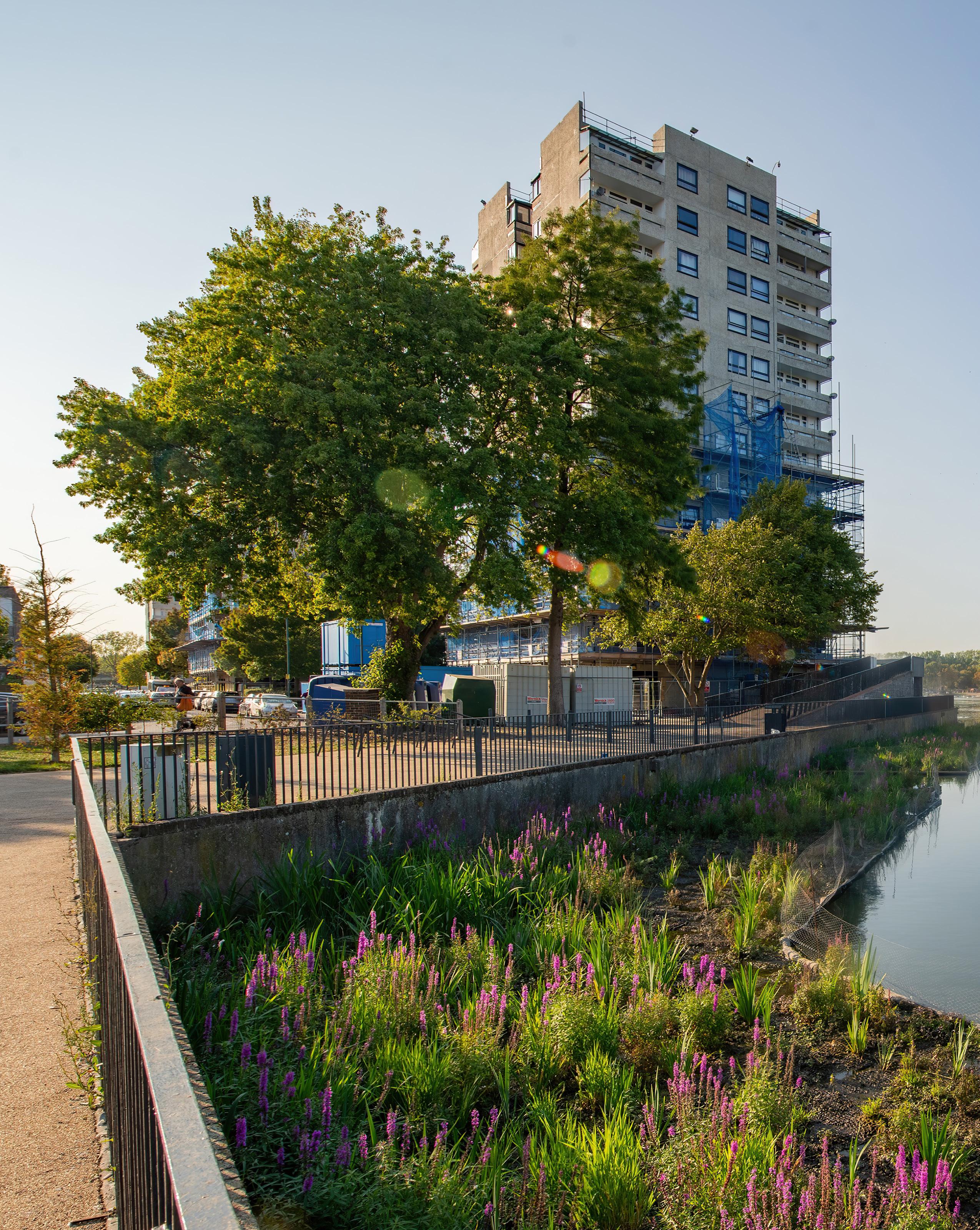
Thamesmead is a remarkable town with a fascinating backstory. A draft masterplan approved by the Greater London Council in 1966 envisaged an alternative to London living, defined by brutalist architecture, spacious homes, elevated walkways and considerable open space. Built on former Thames Estuary marshland, the original homes in Thamesmead were designed to be above ground level to reduce the risk of flooding, while a network of
The regeneration of Thamesmead offers a unique opportunity to restore and revive an important post-war estate through a focus on biodiversity and landscape.
picturesque lakes and canals, sitting alongside green corridors, were created to retain and divert surface water. Hailed as the ‘town for the 21st century’, the first residents moved to Thamesmead in 1968 to much excitement.
However, the 1966 masterplan was never fully realised due to a range of factors – site constraints, insufficient amenities, inconsistency in governance and wider socioeconomic circumstances.In 2014, Peabody took ownership of two-thirds of the

Thamesmead. This meant that for the first time in a generation, much of the town’s housing, community investment activities and land would be managed by a single, wellresourced body. Working with local people and partners, we’re now aiming to improve, grow and look after the town for the long term. With a vision to realise Thamesmead’s full potential, we’re taking a ‘whole place’ approach to the regeneration, investment, and management of the town, which includes managing the town day-to-
FEATURE
Phil Askew 1.
1. Southmere Lake. © Phil Askew, Peabody
9


day, providing better quality homes and amenities, making culture a part of everyday life, supporting communities, and – my area of work – maintaining and enhancing Thamesmead’s extraordinary natural assets. This is set out in detail in our Thamesmead Plan, our core governing document, which is reviewed every five years.
Prioritising the landscape
The landscape of Thamesmead is unlike anywhere else in Greater London. Its sheer extent and variety of green and blue spaces offer us a significant opportunity to bring positive change to local people and the natural environment at scale. To drive this
Peabody owns 65% of the land in Thamesmead – a total area 7km² –and is now steward of:
– 240ha of green space – 5 public parks – 5 lakes
– 7km of canal and waterways – 5km of river frontage – 53,000 trees
– 15 community buildings
forward over the long term, we’ve put in place a green and blue infrastructure strategy, Living in the Landscape. This strategy sets out our approach to making the most of Thamesmead’s outdoor spaces, with a particular focus on the existing landscape’s potential to reduce health inequalities, mitigate the impacts of climate change and create habitat for a wide range of species. Developed with LDA Design and a consortium of experts in topics such as ecology, planning, economics, and sustainable urban drainage systems, it sets out five key programmes for change:
– The Big Blue – making more of our lakes and canals
– Wilder Thamesmead – enhancing biodiversity through design and a biodiversity action plan
– A Productive Landscape –volunteering, gardening and food growing, landscape activation
– Active Thamesmead – play for all, sport and an active landscape
– Connected Thamesmead – active travel using the landscape as a connecting thread
The strategy is invaluable to us, underpinning every aspect of our work
– from informing project briefs to commissioning services, tracking our progress and measuring success.
Day-to-day stewardship
Many of the opportunities identified in Living in the Landscape will be achieved through improved landscape management approaches and working with our Peabody in-house Environmental Services team. In tandem with Living in the Landscape, we’re developing our approach to landscape management through a detailed Estate Management Plan, working with Land Management Services. To this end, we’ve focused on upskilling the team through training with Capel Manor College, a specialist in environmental education. Our aim is to equip them for more nuanced approaches to looking after the land – thinking as horticulturalists rather than simply cutters or mowers.
Recent investment
Over the last five years we’ve focused on developing more detailed approaches to managing the landscape of Thamesmead. In South Thamesmead, where the original brutalist homes sit, we’ve overseen a number of large-scale changes. They include the development of a masterplan by Turkington Martin landscape architects to improve water quality and biodiversity at Southmere Lake, which had previously endured decades of decline. Our investment of £2.5m saw the dredging of 7000m³ of silt to create extensive new reedbeds and floating islands elsewhere in the lake. In doing so, we’ve deepened and therefore cooled the water, lessened anaerobic microbial activity in the bed of the lake, and improved water flow, all of which has improved the water quality and encouraged greater biodiversity. This work, along with better access to the water’s edge, lakeside planting, wooden viewing platforms, a 23m water fountain and a nature trail, has transformed the look and feel of the lake and its immediate surroundings.
We’re now working with Thames 21 and the London Wildlife Trust to help improve water quality in Gallions Lake and our extensive canal network.
With a vision to realise Thamesmead’s full potential, we’re taking a ‘whole place’ approach to the regeneration, investment, and management of the town, which includes managing the town day-today, providing better quality homes and amenities, making culture a part of everyday life, supporting communities.
2. Aerial view of Thamesmead.
© Peabody
3. Archive image of Thamesmead at time of opening.
© Thamesmead Community Archive
2.
FEATURE 10
3.
Courtyard before new planting.
© Phil Askew, Peabody
5. Courtyard after planting.
© Phil Askew, Peabody
6. Southmere Lake.
© Phil Askew, Peabody
7. SuDS planting scheme.
© Phil Askew, Peabody
Within our floating reedbeds we’ll be introducing freshwater mussels, which provide natural filtration. As they retain contaminants, they can potentially help us monitor the health of the water over time.
Greening the grey
We’ve also invested heavily in the spaces directly outside people’s homes in South Thamesmead.
Working with Land Use Consultants (LUC) and Levitt Bernstein Associates (LBA), we’ve transformed around two hectares of public realm in the Parkview and Southmere estates. Here, the designs are sympathetic to the original layout but introduce contemporary elements.
Improvements involved ‘greening’ the grey walkways and enhancing open spaces right outside people’s front doors. Changes included replacing trees that were too big for green courtyards with better-sized, diverse mature trees; installing above-ground planters; planting climbers along parts of the walkways; and introducing beds in the hard and soft landscape. The beds were planted with colourful, textural and biodiverse


perennials, including bulbs and herbaceous plants. Some were designed as attractive raingardens, acting as sustainable urban drainage systems (SuDS). Other improvements to the estate included new lighting, play and seating areas.
Completed in 2020, this has transformed a large area of the original estate and has been well received by residents. Idverde landscape contractors carried out the works during 2019 and 2020, and went on to win a BALI National Landscape award for their involvement. In 2021 the Southmere estate was commended as a runner-up in the Landscape Institute’s award for horticulture and planting design.
Working with the community
A second phase of this work, known as the South Thamesmead Garden Estate, is now underway. This will see more than three hectares of underused green space, including a green walking route stretching from Lesnes Abbey ruins to Southmere Lake, transform into flourishing parkland and other welcoming spaces.
Crucially, this phase of the programme is being co-produced by a group of local people, known as the Community Design Collective. Recruited, trained and paid a part-time living wage, they’ve invested more than 1,000 hours in design conversations, site visits, and client and contractor meetings since the project began in 2018. Moving towards a more democratic approach to design has been challenging and rewarding in equal measure. It’s an approach that we’re constantly learning from and that we hope to replicate.
Alongside these significant programmes of investment and others elsewhere, we’re providing opportunities for local people to participate in nature-based activities and events across the town. Through our community programme, Making Space for Nature, there’s now a growing movement of local naturelovers getting involved in all kinds of outdoor projects – including habitat creation, woodland coppicing and tree planting across the town. Our work has taught us that that small-scale


projects can be as valuable as large-scale changes, so long as what is being delivered responds to the needs of communities and the local environment.
This article provides a snapshot of what we’ve achieved in Thamesmead, thanks to the ongoing support of local people and our partners. But to appreciate the full extent of the changes, Thamesmead is well worth a visit. Seeing is believing. If you’d like to hear more about our work or take a tour of Thamesmead’s neighbourhoods, please go to www.thamesmeadnow.org.uk and get in touch.
Dr Phil Askew is Director of Landscape & Placemaking at Peabody. He is a landscape architect, urban designer and horticulturalist. Prior to his current role he led the design and delivery of the London 2012 Olympic Park at the Olympic Delivery Authority and its transformation into the Queen Elizabeth Olympic Park.
4.
4.
6.
7.
FEATURE 11
5.

FEATURE 1. 12
Led by residents, these urban rambles provide an opportunity for design teams to learn from their local experiences and better understand their sense of identity and the issues as they see them.
A new era for public housing and landscapeled urbanism
The landscape of public housing is under pressure to be multifunctional and to provide amenity, recreation, shade, ecology and biodiversity. Three projects from Karakusevic Carson demonstrate new thinking in council-led schemes.


Landscape within the realm of public housing estates has long been contested. Post-war neighbourhoods possess a visible generosity of it: a strong legacy of the modernist-inspired planning of our cities, when acres of green space were created to promote communal forms of living and offset new densities.
However, neglect, a sense of insecurity, species monoculture and hostile nearby uses such as car parking and busy roadways have rendered many landscapes unusable. Despite their generosity and original intention, some estate open spaces can play an active role in partitioning communities and severing neighbourhoods.
Today, as some councils embark upon programmes of housing and estate renewal, a new era of landscape-led urbanism has emerged. As a practice working within these environments, our brief is to provide new and ever greater numbers of homes. As part of this process, green spaces are impacted, so a positive
relationship between architecture and landscape – and architect and landscape architect – is key. In all our projects we work collaboratively to ensure the creation of new dwellings, but also maximise the potential of landscape to create spaces that will support residents’ quality of life and the future resilience of our cities.
All our council clients have declared a climate emergency and realise the need to rethink neighbourhoods to increase their resilience and improve the lived experience of residents. Typical challenges for estates include a lack of ground floor activity, poor quality pedestrian environments, a lack of cycling links, the dominance of cars, a lack of bin and cycle storage and underutilised but valued green spaces. To support positive change and help mitigate climate impacts, there is significant pressure on landscape and civic spaces to be multifunctional and to provide amenity, recreation, shade, ecology, biodiversity and sustainable drainage, as well as support physical and mental wellbeing.
As we embark upon any project, we look for strategies to improve connections and forge links between existing assets and the rest of the city. London is blessed with lots of green spaces and many of our estate projects, for example Kings Crescent in Hackney, Broadwater Farm in Haringey and St Raphael’s in Brent,
border existing large public parks. However, the mere presence of a park does not guarantee active use of or participation in it. In response, we ensure routes are purposeful and that buildings frame key civic spaces in a positive way, maximising views out for residents, creating open and generous backdrops, while promoting engagement with existing assets such as mature trees often found within post-war estates, but which are frequently uncelebrated.
To understand the role of open space in the neighbourhoods in which we work, we carry out site walks. Led by residents, these urban rambles provide an opportunity for design teams to learn from their local experiences and better understand their sense of identity and the issues as they see them. These walks can reveal neighbourhood stories, anecdotes and characters that can often be surprising and challenge assumptions.
Public realm is typically a key priority for residents on public housing estates. We undertake numerous thematic workshops to inform co-design processes and engage specific groups to discuss potential ways to improve green spaces. As part of these sessions, we take time to work with young people and girls in particular, who often feel excluded in public space and are less likely to
© Karakusevic Carson Architects
1. St Raphael’s Estate Masterplan Axonometric aerial view.
FEATURE
Paul Karakusevic and Abigail Batchelor
13
spend time outdoors. The broad range of workshops for specific groups like children, young adults and old people ensures we capture as many views and experiences as possible, in order to design for flexibility and a variety of needs, aspirations and user groups.
Additional excursions with housing estate maintenance teams and sometimes local police also inform the landscape and masterplan approach. Ongoing pressures on council budgets means money needs to be spent wisely to future-proof landscapes and minimise costly maintenance. Working with clients and collaborating with others we prioritise the development of initiatives that are simple, practical, multipurpose and flexible and so provide ecology, play and amenity simultaneously.
Kings Crescent Estate
Approved in 2013, our masterplan for the 1960s Kings Crescent Estate in Hackney was an early exemplar in promoting alternative approaches to estate renewal and new and experimental landscape. Renewal of the neighbourhood is ongoing
with phases one and two delivered in 2017. At the heart of change are new mansion block buildings that provide mixed tenure homes and work with existing estate buildings to create a series of courtyards. Developed in close collaboration with muf architecture/art, the strategy for landscape across the estate is twofold.
At the heart of each of the three communal courtyards created are a series of discreet and intimate responses intended to bring residents in both old and new buildings together with young child play space, small planted gardens, quiet seating areas, allotments and growing spaces to promote interaction and engagement with nature. The main articulation of the new neighbourhood however is its central east–west street – a linear axis designed to open the estate and improve connectivity to adjacent amenities, but also be a civic space in itself – a sociable, active and consciously playful space to linger rather than simply pass through. The traffic-free space is lined with trees and is full of new planting and playful installations to encourage imaginative

responses from people of all ages, including a huge table for impromptu open-air gatherings. Supporting the life of the space, front doors and the communal entrances to the new buildings all open out onto the space ensuring regular use by and visibility of the community. The generous high-ceilinged lobbies feature large openings that provide views from the street through to the courtyard landscapes. Elsewhere, non-residential uses at ground level at key locations, such as retail and community use, brings activity to occupy and spill out into this public realm.
Broadwater Farm Estate
Completed in the 1970s, the modernist landscape of the Broadwater Farm Estate features extensive areas of green, but much of it is a visual resource rather than an active space. Dominated by car park undercrofts beneath residential buildings, pedestrian movement about the neighbourhood was originally separated to upper decks, which also meant a separation between people and their local landscapes. Following demolition of connective upper-level walkways in the 1990s, residents were left without defined pavements or routes through the estate.
Collaborating with What If projects and East Landscape architects, we prepared an Urban Design Framework that establishes five core principles that, alongside providing new homes, will transform the landscape and the experience of the estate over more than ten years. Developed with the community they include the creation of safe and healthy streets, a focus on welcoming and inclusive open spaces, more active ground floors and enhancing the existing character of the neighbourhood.
To ensure a coordinated approach to neighbourhood change, the framework seeks out synergies between existing assets and new interventions. One of the central proposals is the creation of a new route through the estate following the line of the culverted river Moselle. This connective artery aims to better link the neighbourhood to the adjacent Lordship Recreation Ground,
The main articulation of the new neighbourhood however is its central east–west street –a linear axis designed to open the estate and improve connectivity to adjacent amenities, but also be a civic space in itself – a sociable, active and consciously playful space to linger rather than simply pass through.
2.
2. Kings Crescent Estate Phase 1 & 2. View of new buildings looking west along Murrain Road.
FEATURE
© Jim Stephenson
14
but also provide the axis for new residential buildings and new civic spaces. Elsewhere, the framework includes the retrofitting of existing communal entrances and simple measures, for example encouraging diverse planting regimes in existing spaces and proposing less frequent lawn cutting to allow wild flowers to thrive and carbon to be sequestered.
A common critique of post-war estate landscapes is their overpermeability. Our work with the community at Broadwater challenged this perception and residents demanded that the openness of the numerous courtyards be retained to minimise loss of public space and prevent the privatisation and securitisation of the area. In response, our framework retains routes through the network of courtyards, whilst prioritising key connections to aid wayfinding. Desired accessibility of landscape has also informed the design of a new residential building that is conceived as an open courtyard and a building in two parts, echoing the existing organisation of the estate.


St Raphael’s Estate
Bordering the meandering landscape of the River Brent and the extensive Brent River Park, our work at the 1960s St Raphaels’ Estate in Wembley with Periscope landscape architects revealed a surprising misconception about open space that has directly influenced the masterplan now being taken forward. One of the main outcomes of our extensive consultation with the community was that the generous open space nearby was seen as a place of concern and potential danger, rather than one that was readily valued or celebrated. Homes physically turned their backs on the space, and it was evident that most people did as well, in particular young women and girls.
Through co-design conversations we together developed six residents’ principles that informed an estate-wide strategy for change. This included the provision of new affordable homes, new community facilities and improved access to the estate, ensuring all streets are safe and welcoming and improving the existing green areas and the park adjacent to the estate.
To achieve this vision our masterplan involves the creation of infill homes within the footprint of the existing estate, but also by building along the edge of the park on an area bordering the busy North Circular Road. This approach was not without controversy. London-wide policies prohibit building upon open space; however, the evidence from the community, the existing condition of the park and proposed benefits persuaded the council to adopt a different, but very site-specific position which was endorsed by the Greater
London Authority (GLA).
Conceived as elements nestled within topography, the three new landscape-led apartment buildings will directly balance loss of space, by introducing new activity, with new homes providing new life and contributing to physical park improvements that will increase safety with new pathways and new lighting, promote biodiversity through new wild flower meadows and planting, support resilience through the addition of flood attenuation basins and promote new use through growing spaces, seating areas and play amenities including an outdoor gym and skate park.
In creating new and adapting existing housing for the future, landscape has a fundamental role to play. Well-designed, meaningful and well-loved spaces engender ownership and provide opportunities to improve wellbeing and for communities to come together.
Within the realm of the public housing estate, the pressures upon councils to introduce new homes can seem overwhelming. The integration of estates and neighbourhoods through new connectivity and spaces with common purpose is key. Through our work in public housing we have learned that the development of strategies through collaboration and co-design is the best way to better understand communities, to challenge and interrogate assumptions and ensure lasting legacies.
Paul Karakusevic is Founding Partner and Abigail Batchelor is Associate Director at Karakusevic Carson Architects
3.
5.
4.
3. Broadwater Farm Estate Illustrative view of Willian Road towards the Civic Space.
© Jim Stephenson
4. Broadwater Farm Estate Axonometric showing the UDF network.
© Karakusevic Carson Architects
5. St Raphael’s Estate Masterplan; View across Brent River Park towards the new neighbourhood.
FEATURE 15
© Slab Ltd
The landscape legacy of Lafayette Park, Detroit


Howells’ David Henderson pays tribute to the work of Mies van der Rohe, Ludwig Hilberseimer and Alfred Caldwell in the design of two East London housing schemes.
1. Townhouses in Lafayette Park in Detroit. Constructed between 1956 and 1959, Lafayette Park contains the world’s largest collection of buildings by Mies van der Rohe. © Alamy
2. Lafayette Park on completion.
David Henderson

FEATURE
1. 2.
16

At Howells, the sites we build on and the residential typologies we work with cover all scales and densities. There is no one-size-fitsall and, particularly in London, near public transport nodes, we are building housing of significant height. The questions we face include establishing appropriate scale and ensuring that there is always a close and meaningful relationship to the landscape, as has often been the case historically.
In the early 20th century, the idea of the garden city tended towards a low-rise, detached suburbanisation, which threatened the very landscape that made living there an attractive idea in the first place. As Chamberlin, Powell & Bon, architects of the Barbican in London, said, ‘We strongly dislike the Garden City tradition, with its low density, monotony and waste of good country, road, kerbs, borders and paths in endless strips everywhere.’¹ By the time of Le Corbusier’s Ville Radieuse urban planning concepts, the pendulum had swung towards proposed highrise dwelling units seeming to float disconnectedly above an indeterminate salad of greenery.
While the proximity to green infrastructure is important, and the
need to build taller and more densely is an increasing necessity, neither extreme offers an answer to the kind of challenges we are faced with now. However, one mid-century development in the US incorporated elements of both philosophies to good effect.
Surprisingly, given its scale, Lafayette Park in Detroit was a commercial enterprise, with the central parkland and street landscape developed by Howard Greenwald, working together with architect Mies van der Rohe, urban planner Ludwig Hilberseimer and landscape architect Alfred Caldwell. They shrewdly appreciated this would add significant value to the real estate in exactly the tradition of London squares and parks of the Georgian period.
When Lafayette Park was newly completed in 1963, it looked to be somewhat sterile, dominated by parking, roads and hard surfaces. Now, however, after a period of 60 years, the landscape has matured and what seemed an abstract flexible pattern of development is now a highly valued place. The project has fairly high densities and incorporates a mix of building scales, from townhouses to flats up to 22 storeys, and this variety of scale, alongside its landscape, is what provides its quality and interest.
The scheme is distinguished from its contemporaries by a clear sequence of densely landscaped spaces, moving progressively from open parkland to private courtyard via a network of green streets and pathways.
It is a dwelling experience that is immersed in nature, a humane civilised compromise that recognises both the attractiveness of the garden city ideal and the need for increased density, but which treats the landscape as a key component in a legible sequence of spaces, not just as background scenery.
In its recognition of the value of landscape to housing development, Lafayette Park draws on a historical narrative which still has contemporary relevance. It has a collection of buildings designed by one of the acknowledged masters of 20thcentury architecture, and yet it is the maturing landscape which ultimately gives it its quality. In its mix of scales and multiple uses it could almost be seen as a prototype for what the 15-minute city is now.
Although it has a very different context, Howells’ project at Royal Wharf – a new Thameside district in east London of over 15 hectares – addresses many of the same challenges as at Lafayette Park.
We believe that the key to
FEATURE
3.
¹ Chamberlin,
& Bon,
15 January 1953 17
3. Drawing Sheet P-1, Planting Plan, from the Lafayette Park Construction Documents Set of 1958.
Powell
Architects’ Journal

successful places are mixed demographics, housing types and tenures – with streets and homes that people aspire to live in as a vital part of balanced and strong communities. Looking to the urban characteristics of typically successful residential districts forged in the 19th century, we investigated a new urbanism for this district, which is in the London Borough of Newham, focused on grid densities, building heights, road and pavement widths and people-to-gridspace ratios.
Reinterpreting traditional terraced housing for the 21st century, the townhouses were among the first buildings at Royal Wharf, leading the way in demonstrating a familiar urban streetscape of three- and four-storey terraces, screened by front gardens with hedges and bookended by taller mansion blocks and residential towers.
Looking at the wider area, we analysed the river context several miles east and west of Royal Wharf’s Thames frontage, exploring ways for a new community to experience London’s river. Understanding that the key to a sustainable neighbourhood
was to look beyond the site’s high-value frontage, we analysed local networks of green spaces, community infrastructure and transport stretching from Canary Wharf to the Thames Barrier.
We were fortunate to benefit from two significant established green spaces nearby in Lyle Park and Thames Barrier Park. We integrated these, along with our own newly created Royal Wharf Gardens, into the development, with a high street running through the site.
This high street connects adjacent communities with the river, a new Thames Clipper stop and inland Docklands Light Railway stations. Royal Wharf’s high street also gathers essential local amenities, including dentists, doctors and food shops. A new primary school for 420 children, a nursery with 60 places and a community centre located at the heart of Royal Wharf lay the groundwork for a cohesive and socially connected community.
Another of our masterplans, London City Island, presented a different set of challenges and opportunities. London City Island (LCI)
is a new residential and culture-led neighbourhood located in Canning Town in the heart of east London, with distinct public spaces and a maturing soft landscape edge to the River Lea. The masterplan includes 1,706 homes, shops, restaurants, cafés, offices, an energy centre and new spaces for both English National Ballet and Queen Mary and Newham College.
London City Island was a brownfield site where all evidence of its former use had been erased. A key driver in the development of the masterplan was the dramatic meander in the River Lea, creating access to an almost continuous waterfront while allowing for a less structured urban geometry. Proximity to a major public transport interchange and wider amenities at Canning Town was achieved by providing a new lifting bridge, allowing us to develop more densely while also greening and rehabilitating the previously industrial waterway.
Historically, the buildings on site had been undistinguished other than the original house and orchard, a memory of which survives in the
We were fortunate to benefit from two significant established green spaces nearby in Lyle Park and Thames Barrier Park.
FEATURE
4.
4. Royal Wharf. © Greg Holmes
18
In all three projects, the housing design was preceded by the creation of a destination: the park in Detroit; the boulevard connecting new and existing green spaces at Royal Wharf; the garden and river edge at London City Island.
street name, Orchard Street. The surrounding presence of water therefore offered an opportunity to develop a new narrative of riverside buildings surrounding a central garden, an arrival square fronted by the new spaces for English National Ballet and a new landscaped water’s edge.
The landscaped spaces, one intensively planted and the other more formally surfaced, are critical in creating a liveable environment, a meeting place, a connecting point between visitors, students and
residents and leading through to new vantage points around the extensive waterfront. We were able to cluster the tall buildings fairly closely together without compromising daylight, privacy or views, by carefully aligning and angling facades away from each adjacent block. This created a relatively tall and dense but extremely liveable development with daylight reaching deep into the central green spaces.
The buildings share a language of brick architecture distinguished by bold use of colour but acting as a foil

to the greenery of the waterfront park. Overall, the collective has a greater impact than the sum of its parts, like a mini-Manhattan.
The common thread between Lafayette Park and our two projects has been the understanding that, for the project to be successful, it cannot simply adhere to an abstract idea (à la garden city or Ville Radieuse). In all three projects, the housing design was preceded by the creation of a destination: the park in Detroit; the boulevard connecting new and existing green spaces at Royal Wharf; the garden and river edge at London City Island.
At Lafayette Park, the landscape has been a 60-year investment in the quality of the dwelling experience. At Royal Wharf, and London City Island, after about five years, it is already apparent that the green spaces are becoming well established and we hope that in due course these two new places in London will mature in the same way.
David Henderson is an architect and Partner at the London studio of Howells

FEATURE
5.
6.
5. London City Island.
© Hufton + Crow
6. London City Island.
© Hufton + Crow
19

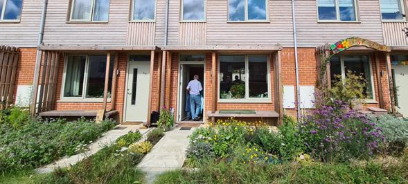
Housing, health and landscape
Appleby Blue is a development reimagining the almshouse for 21st-century living. Grant Associates’ Keith French explains the vital role of landscape in the project –and outlines three other schemes that show how the practice incorporates nature into housing environments.

Appleby Blue, a social housing development of 57 almshouses in Bermondsey, south London, recently opened its doors to welcome its first 63 residents. Managed by United St Saviour’s Charity, the building provides independent living with a resident support model for over 65-yearolds in Southwark.
During the early stage of the project, we visited the charity’s existing almshouse community at Hopton’s Almshouses in Southwark, where residents explained to us the role of the garden for them: the importance of seasons and the joy of watching birds and wildlife, space to garden and a sense of a mini oasis while still living in the heart of the city. We were also advised how vital it is for the almshouse experience to feel comfortable for visitors. With loneliness and social isolation on the rise – especially for retired people –the almshouse should also appeal to families with young children seeing their elderly relatives. It was therefore important for us to create inviting
social spaces and gardens for the whole family.
From the outset of the project, in close collaboration with Witherford Watson Mann Architects, the landscape and architectural design was developed to create a close fit between the building uses and a distinctive and seasonal landscape across different levels. The landscape was never considered as a cosmetic addition, but rather as an integral part of the overall design, use, atmosphere and wellbeing of the community.
Central to the landscape concept is the idea of time and seasonality which is reflected in the two primary garden spaces. The gardens frame the living environment at different
Keith French
1. The Garden Court at Appleby Blue, London.
© Philip Vile
20
1.
Extensive research studies show how gardening benefits the wellbeing of communities, from reducing stress and lowering disease risk to increasing life satisfaction and promoting learning.
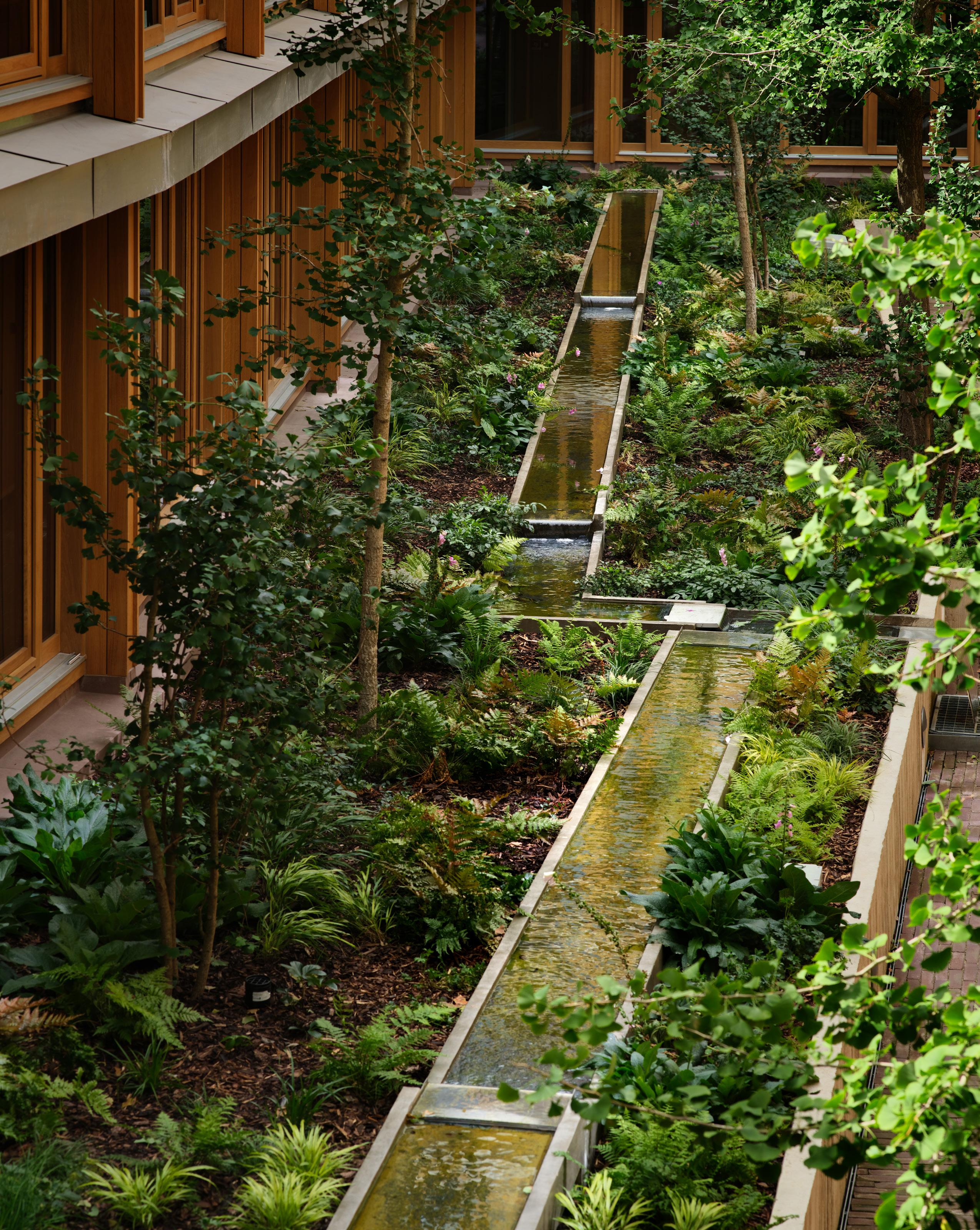
levels, bringing the changing colours, textures, sounds and light of the seasons into the residents’ and local communities’ everyday experience. Conceived as an abstract woodland glade, the Garden Court provides direct and indirect views of the garden spaces as you move through and around the building, with a raised and gently cascading linear water feature running between a grove of gingko trees and an understory of seasonal woodland flora including ferns, sedges, hellebores and foxgloves. The acoustics of the Court, coupled with the sound of the water feature, create a sanctuary space for socialising and relaxing in peace and quiet.
The Garden Court links to a double-height indoor Garden Room. This light-filled area invites the neighbourhood to engage in the array of intergenerational activities in this new community space, including the community kitchen, set to deliver culinary events based on upskilling and nutrition as well as using the herbs and produce grown on the roof terrace. Extensive research studies show how gardening benefits the wellbeing of communities, from reducing stress and lowering disease risk to increasing life satisfaction and promoting learning.¹ We were keen to enable this on the secondfloor roof terrace space, where there is more direct sunlight and residents can enjoy views out. The Productive Garden features a series of interconnecting raised beds for growing herbs and vegetables, as well as a planting mix of herbs, fruits, vegetables and companion planting.
Raised beds, using pre-cast board-marked concrete, have enabled recreational gardening activities to maintain accessibility despite residents’ potential loss of mobility. Some of the beds were left prepared for residents to garden, while others were planted with a mix of fennel, rosemary, thyme, sage, mint, marjoram, wild strawberry, rhubarb as well as local apple and pear tree varieties. Adjacent to the raised beds, potting tables and storage spaces for residents’ gardening tools make it comfortable and practical.
Both gardens will be managed by a local gardening group, with United St Saviour’s working alongside Bournemouth University research partners to explore how multigenerational, socially inclusive activities can be co-created with older people around food growing, cooking and meal sharing to improve their health, wellbeing and social connectedness.
The almshouse is designed to encourage residents and non-residents to come together through its open nature and progression of places
to share, extending from the busy public high street to the more intimate walkways, to the different garden spaces – cultivating a strong sense of community and reducing loneliness. The Appleby Blue development sets a new benchmark for the provision of older people’s social housing and brings nature into the heart of the living environment. Designed specifically for today’s generation of older people who want to lead an active life in the heart of the inner city, it is creating a community hub for them in central London.

FEATURE
¹ Soga et al., 2017, Health benefits of urban gardening: improved physical and psychological well-being and social integration
2. The Productive Garden on the roof terrace at Appleby Blue, London.
© Philip Vile 2.
21

Accordia, Cambridge
Accordia in central Cambridge is a large-scale housing project, and a pioneering collaboration between Feilden Clegg Bradley Studios, Alison Brooks Architects, Macreanor Lavington and Grant Associates.
The relationship between the homes, the landscape, trees and different kinds of external space was central to the project. The ‘Living in a Garden’ landscape concept inspired different gardens throughout Accordia, each with a function or theme: the ‘Kitchen Garden’, the ‘Long Walk’ and the ‘Central Lawn’. All spaces are linked by a network of paths and clearly defined by walls, hedges and boundaries, featuring mature trees and new planting.
Today, 15 years on, Accordia boasts beautiful public gardens, garden streets and planted mews spaces, food and play gardens, well-connected pedestrian and cycle routes, and discreet, integrated cycle and car parking for all dwellings. The diversity of planting and well-established trees stands as a testament to the thoughtful selection of species,
supporting biodiversity and creating an ever-changing tapestry of colour and texture of the public spaces.
What none of the team originally foresaw was Accordia’s dramatic success in generating a sense of real community. We began to observe this anecdotally, but it was interesting to see research by Cambridge University, which focused on the incidence of wellbeing as defined by the New Economics Foundation.²
Researcher Jamie Anderson looked at the attitude to neighbourhood life and the use of the community outdoor space provision at Accordia, compared with a similar but more traditional neighbourhood. The 2015 study found that living in a neighbourhood with a higher ratio of communal gardens is associated with higher levels of wellbeing and community.

‘Living in a communal garden’ associated with well-being while reducing urban sprawl by 40%: a mixed-methods cross-sectional study. Front. Public Health 3:173. doi: 10.3389/ fpubh.2015.00173
FEATURE
² Anderson J (2015)
Case Study
3. and 4. Accordia, Cambridge.
© Tim Crocker
22
3.
4.
Extensive research studies show how gardening benefits the wellbeing of communities, from reducing stress and lowering disease risk to increasing life satisfaction and promoting learning.
Case Study
New Islington, Manchester
Grant Associates’ approach to New Islington was always people-centred, planning for an existing and new community of people and incorporating waterways linking the historic navigations between the Rochdale and Ashton Canals to give the new neighbourhood an identity of waterside living and parkland.
Located to the east of Manchester city centre, the vision was to take this unloved, low-density area of the city fringe and transform it into a Copenhagen-inspired dense urban neighbourhood. Today New Islington has transformed the area, with Manchester Evening News calling it an ‘oasis’ for Manchester.
Cotton Field Park, the 1.5ha epicentre of New Islington has established a focus and landscape identity for the neighbourhood, and gives residents a unique relationship with the canal network. The park consists of a new body of water, a landmark grove of Scots pines around an urban beach, with a boardwalk that links together several distinctive islands. The extensive planting includes an orchard island, wetland edges and reed beds, and community
Case Study

gardens. The combination has helped not only appeal to a new population of human residents, but other species too, including the many Canada geese who call Cotton Field Park home.
The 20-year regeneration of New Islington has been transformative – for Urban Splash the developer; for Manchester; and for us as a
Brabazon, Bristol
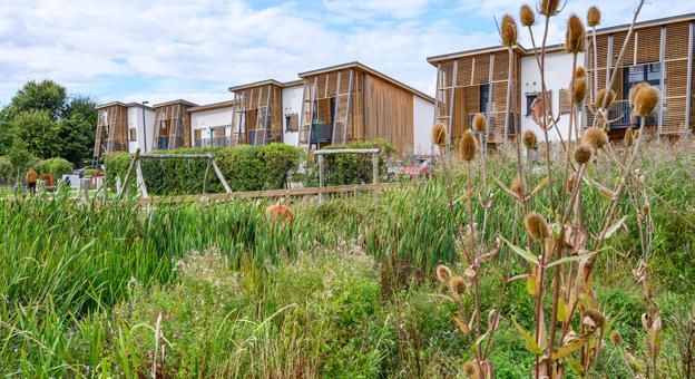
Brabazon is a new peri-urban neighbourhood for Bristol, bringing the historic 142-hectare Filton Airfield site back into use. The green and connected, low-carbon masterplan sets out a vision for a high-density, sustainable, new district for Bristol.
From the outset, the vision for Brabazon was to be a green, leafy place where pedestrians have priority. Planned on a framework of
15-minute neighbourhoods, the masterplan’s sense of place and identity is very much shaped by its landscape, public spaces and sense of aviation heritage. Two kilometres of pedestrian and cycle routes link a series of linear parks and gardens, as well as a new 6ha destination park and landmark lake adjacent to a potential new entertainment venue at its heart. The site incorporates a Heritage Trail which connects the new districts with the Aerospace Bristol

practice. It gives the UK a great example of urban development done differently and sets a pioneering precedent for the role of green and blue infrastructure, with a neighbourhood filled with green space, water, wetlands, islands wooden sculptures, and a canal marina.
Museum and the historic, listed Hangar 16U, which is set to be a new local, social hub for the community.
The phased growth of Brabazon is linked to key sustainable travel milestones to lower car usage. Car parking is provided off-street, and the streets are at a scale that prioritises pedestrians. The streets – lined with trees and rain-gardens – will offer seating and play space to encourage community and interaction among residents.
A theme in each of these projects is human connections with the environment around them and finding new ways to bring people closer to nature. There’s a sense that if you develop the right environment, you nurture a community of people who like their setting and are therefore more likely to look after it. That’s been an interesting theory that has proved to be very true among these projects that we’ve worked on – all are linked by a strong sense of community and ownership, and a commitment to looking after our collective world together.
FEATURE
5. New Islington Cotton Field Park, Manchester © Urban Splash
6. Brabazon, Bristol
© YTL/FCBS/Grant Associates
6.
23
5.

Courtyard and garden: landscapes of palliative and social care

More than any other event in recent years, the Covid-19 crisis revealed how many vulnerable older people spent their last years confined in residential care homes – and how poorly managed and routinised life in such homes had become. In recent decades, a number of radical initiatives have recast residential and therapeutic care, offering hope for the future.
At the heart of these initiatives is a more imaginative relationship between building design, landscape enhancement, and the connectivity of both to the ongoing life and culture of the communities they serve.
The development of the modern hospice movement from the opening of St Christopher’s Hospice in Sydenham in London in 1967 has been a UK success story and has also expanded the ways in which we think about care. Originating as a response to the shocking conditions
in which many people died in geriatric wards, the public quickly adopted local hospices as their own. In doing so, communities have learned how to live with the dying in more supportive and generous ways. First designed as small inpatient units, hospices have evolved into ‘open house’ therapeutic settlements, offering a wide range of support services as well as short-term residential care, with people coming and going, thus turning them into what one architect termed ‘a living village’. Now other not-for-profit initiatives
First designed as small inpatient units, hospices have evolved into ‘open house’ therapeutic settlements, offering a wide range of support services as well as short-term residential care.
FEATURE v
Ken Worpole
1.
8. Orchard Garden at rear of St Wilfrid’s Hospice, Eastbourne, enclosed by waterretaining bund of wildflower grassland. © Ken Worpole
Ken Worpole introduces the updated version of Modern Hospice Design, which addresses both architecture and landscape.
8.
24
© Ken Worpole
First-time visitors may be surprised to find that the central feature of the new hospice is a large public ‘street’, a place where the public are welcomed in, and the café busy at all times.
in palliative and social care are following suit, imaginatively integrating uplifting design with landscape and garden elements to greater therapeutic effect.
St Wilfrid’s, designed by Nic Hoar of RH Partnerships and landscape architect Rick Rowbotham (Studio Loci), was completed in 2013, and is just one of a number of fantastic examples included in Modern Hospice Design. It has 20 inpatient beds, with 250 – 300 admissions a year. The average length of stay in the IPU (Inpatient Unit) is 20 days, with around 30% of inpatients discharged back to their home or to a care home, symptoms under control. Additionally, nearly 1,500 patients are currently supported where they live, whether this is a domestic residence or a residential care home, though many will use the hospice regularly for consultations and therapies.
Sited close to a main road, and adjacent to a large supermarket and
college, this was not the ‘sheltered, rural retreat’ that some supporters hoped for or expected ‘but it was perfect for a new hospice wanting to actively engage the community and change attitudes,’ former CEO Kara Bishop told me. An ‘open house’ philosophy is soon evident. First-time visitors may be surprised to find that the central feature of the new hospice is a large public ‘street’, a place where the public are welcomed in, and the café busy at all times. This long, double-height linear atrium runs from the entrance to the far end of the building, with large rooflights providing natural lighting. For the hundreds of people who come here daily – as patients, visitors, family members or staff – it is a ‘home from home’.
The gardens are an integral part of the hospice’s ethos and support. The Courtyard Garden sits in the centre of the inpatient unit and is primarily for use by patients and their visitors, with the facility to move patient beds easily
into the open air: a haven of peace and tranquillity. The Orchard Garden at the rear of the building has patient rooms facing onto it and is a riot of grass meadow and wildflowers at its banks, looking down to a star-shaped planted area, gazebo and beehive. This garden has been structured as a bund from soil excavated from the site, capturing water for the impressive apple orchard and more formal gardens at ground level, for use by patients and staff. The Wellbeing Garden at the front of the building is a mix of trees, herbaceous borders and planters and is used by outpatients and general visitors to the hospice, as well as staff and volunteers.
The value of natural landscapes and those of the built environment have long been recognised as having a profound impact on a person’s sense of wellbeing, and here these effects are seen in abundance. Between them, Rowbotham and Hoar have created a new kind of public health

FEATURE
9. Curtilage garden at Maggie’s Southampton.
Building architect: A_LA , garden designed by Sarah Price Landscapes.
9.
25
Hospice design essentials from Rick Rowbotham, landscape architect at St Wilfrid’s Hospice.
– A landscape-led masterplan determining the disposition of built structure within a site-wide landscape
– A design narrative that is poetic, engaging and familiar
– A predominately ‘green floriferous’ outlook for calming impact
– A hierarchy of spaces from the public, to semiprivate to private
– The use of intimate enclosure and courtyard spaces, for privacy, contemplation and sanctuary
– A secular space for meditation and prayer
– Private outer space accessible to bed-bound IPU patients
estate, a place of reflection and hope for the many thousands who use its facilities at one of the most difficult times in life.
On a contrasting site in Bermondsey, south London, architects Witherford Watson Mann (WWM) recently completed Appleby Blue Almshouse, another of the hospices to feature in Modern Hospice Design.
Writing in Wallpaper magazine architectural critic Giovanna Dunmall says, ‘There is no doubt that Appleby Blue will become a blueprint for the provision of older people’s social housing.’
WWM took their inspiration not from conventional residential home typologies, but intriguingly from the liveliness and courtyard culture of Bermondsey’s long history of coaching inns. Other recent historical precedents were influential too. The area was famous in local government history for having a municipal Beautification Department in 1921, combining public health, housing and recreation in one programme, underwritten by an extensive network of new parks, playgrounds and green spaces. Chaired by the legendary Mayor Ada Salter, Bermondsey
– Sheltered external positions to offer protection during inclement weather
– Provision for all users from family members who will be the primary users, to patients, staff and visitors. There should be unimpeded visibility between internal and external space
– Private space for staff members
– Use of running water and reflective water
– Planting design for seasonality, colour and smell
– Animation of the site through biodiverse landscapes to attract wildlife, birds, and insects
became an international watchword for ambitious public design, which United St Saviour’s Charity has revitalised with this outstanding project, along with Southwark Council support.
Having visited Appleby Blue on four occasions now, I admire its open sightlines and bold patterning of access levels and inner connectivity, agreeing with the Guardian’s architecture critic, Oliver Wainwright, who has described its interior glazed corridors and terraces as those of an Alpine spa. There is also a touch of the Globe Theatre and the South Bank (if not a whiff of the Thames) to the Garden Court as a performative space, as there is to the gardens at St Wilfrid’s, where their designer Rick Rowbotham saw their function as offering a place of ‘intimate enclosure, privacy, contemplation and sanctuary’, as do the gardens in Shakespearean theatre. On my last visit to Appleby Blue, only weeks after the first residents moved into their new homes, it was clear that the building had already settled down and was buzzing with life. It would be good to think that the old assumptions
about residential care as a retreat from life are finally changing.
Ken Worpole’s Modern Hospice Design: the architecture of palliative and social care, was published by Routledge in October 2023.

There is no doubt that Appleby Blue will become a blueprint for the provision of older people’s social housing
FEATURE
26
1. Macmillan Cancer Care, Hereford.
© Fira Landscape Architects
 Jane Findlay
Death is an unusual topic of conversation for a landscape architect. We usually discuss the benefits of landscape for improving our health and wellbeing. The way we design our urban and rural landscapes to promote a healthy population and even the design of hospitals, where the landscape can aid the healing process, is a concept pioneered by Professor Roger Ulrich.¹ But while death is something that we don’t talk about much publicly, or perhaps think about on a day-to-day level, it’s a feature in all of our lives.
Where do you want to be when you die? Chances are, a hospital isn’t top of your list. Hectic places, stressful, with stark fluorescent lighting and hardly any privacy or dignity. Few of us (less than one in ten, in fact) would prefer to die in hospital.² No wonder around two-thirds of us would like to be where we live, with the people we love, at the end of life. But, for a whole host of reasons, that isn’t always possible.
How do we make sure the place where we do die is the best it can be for supporting a ‘good death’?
¹ https://www. healthdesign.org/ knowledge-repository/ view-throughwindow-mayinfluence-recoverysurgery#:~:text= Patients%20 with%20nature%20 window%20 views,pain%20 medications%20 such%20as%20 narcotics.
² National Survey of Bereaved People (VOICES): England, 2015
³ ‘Introduction to Maggie’s Architectural Brief’, Maggie’s Centres, London, undated
Answering that question is Ken Worpole in his book Modern Hospice Design: The Architecture of Palliative and Social Care, in which he assesses the needs of people living with a terminal illness and looks at the places that support them, both today and in the past. He advocates care settings that, in the words of Maggie Keswick Jencks, ‘rise to the occasion’.³
Historically, humans used to place a great deal of importance on death and the rituals associated with it. However, in contemporary society there has been a distinct shift. Instead of embracing it as a natural part of life, there is a tendency to conceal and
Jane Findlay responds to some of the issues raised in the Modern Hospice Design book and looks at what they mean for landscape practitioners.

distance death within unremarkable, sterile institutions. A hundred years ago, we were likely to die of infectious diseases like pneumonia; ill health would be short. We tended to die at home, in our own beds, looked after by family. The 20th century saw a revolution in healthcare. We developed new medicines like penicillin to treat infectious diseases, for example, and new medical technologies were invented. Because they were so big and expensive, they were housed in large, centralised buildings, shaping our modern hospitals. Post-war universal healthcare systems, like the NHS, allowed everyone easy access to the treatment they needed. The result was that lifespans extended from about 45 at the start of the century to almost double that today.
We now overwhelmingly die of degenerative diseases, like cancer and heart disease. It means that people tend to have a long period of chronic illness at the end of their lives in which they will spend a significant amount of time in hospitals, hospices, and care homes. These buildings are widely regarded as being awful places to be, not just because people are there for a negative reason, but also because the buildings and their surroundings tend to be institutional and often uninspiring, with miles of long corridors, no natural daylight, and a feeling of loss of control for the patient.
Dying well, or what constitutes a ‘good’ death will mean different things to us all. Most people express a wish to die at home, but often care for the chronically ill can be too complex for
FEATURE
27
1.
families. Can we make the end of life as meaningful and enriching as the beginning, not just for the patient but for families too? Worpole suggests that a careful blend between a homely and supportive environment with architectural and landscape interest that is imaginative and bespoke can be achieved in the new generation of supportive facilities, developed in response to the increasing anxieties about ageing by patients and their families. They are also an essential part of the care system to relieve the pressure on our hospitals.
Worpole uses the example of Maggie’s Cancer Care Centres as exemplar projects. Although not hospices, they are a hybrid of beautiful, imaginative and homely facilities with gardens and nature at their heart; to support the person and family during their most difficult time.
For decades my practice, Fira, has been designing healthcare environments, from large acute hospitals which are highly technical to small, homely hospice and care units. The concept that contact with nature can positively contribute to patient recovery is accepted by the medical profession and is essential for palliative care. By combining a consultative approach to form a detailed understanding of the needs of patients, staff, family and visitors, we place people at the heart of the project. The design brief, as Worpole states, is essential to a successful scheme.
The feedback and post-occupancy evaluation bears this out. We are continually surprised and moved by the letters of thanks from patients, families, and staff on our hospice and Macmillan Cancer Care projects.
They appreciate the care and attention to detail, such as access to beautiful gardens, the sounds of nature, the smells, uplifting colours, allowing choice at a time when there is little control over their medical needs.
The learnings from these small schemes continue to influence our approach to large healthcare projects, but they also influence the way we design healthy and beautiful places where people live, work, learn and play. Most importantly it raises the important question of how we design so that we might grow older in our own homes, within supportive communities.
Jane Findlay is past president of the Landscape Institute and founding director of Fira Landscape Architects.

FEATURE
For further information on our versatile products visit woodblocx-landscaping.com or telephone 0800 389 1420 Sustainable timber solutions for the built environment with limitless design potential The world’s #1 modular timber system Street Furniture | Raised Planters | Free Design Service LIJ Advert 2023.indd 1 23/3/2023 7:54 pm 28
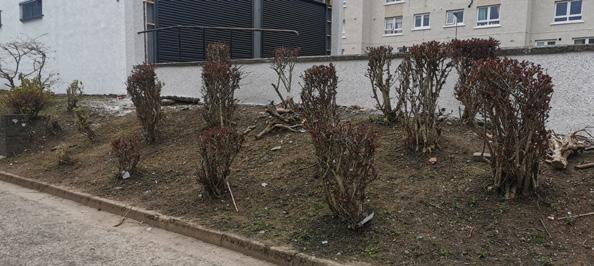
Retrofit first in Barrow-in-Furness

and 2. View of estate before work started and on completion. © Farrer Huxley FEATURE 29
1.
Noel Farrer

Barrow is my largest local town. I first became aware of the tenement blocks on Barrow Island through a Landscape Institute competition that took place in 2013. I could see why I had not visited before. It is unnervingly quiet and feels a little unsafe, with unoccupied run-down tenements overlooking degraded and car-dominated streets. When we visited the flats, we found ourselves pushing through heavy cobwebs on the communal staircases, indicating that whole floors were deserted. Six hundred homes were mostly empty and forgotten.
The tenements were built in the late 19th century to house the workers of the nearby dockyard and steelworks. Through engagement with residents, we understood that many Barrovians started their lives in the flats. Many who lived here as children fondly described the sense of community shared by everyone. These
Retrofitting a new landscape has not only benefited existing residents but also encouraged a new generation to move in.
homes were often the first rung on the ladder for those coming to Barrow for work and were an important starting point for many people living here now.
Changes in the nature of the work, with manual labour and riveting replaced by a greater focus on engineering skills, contributed to the closure of the steelworks in 1963. The dockyard workforce also steadily declined. People were also prepared to live further afield and travel by car. The flats were no longer desired becoming part of one of the most deprived wards in the UK. We began work in a place with little direction or prospects and where drug- and drink-related issues gripped the community.
The deterioration of urban housing is not confined to Barrow. Many towns are blighted by the loss of large-scale employment and redundancy. This climate of economic decline results in house prices so low that traditional development is not an option. At Maritime Streets, the flats were selling at auction for between £8,000 and £20,000, with the investment needed to bring them to a habitable level much greater than this. As the flats are all privately owned, and the council only own the surrounding roads and open
space, investment in the landscape was the only option for change. A grant for £1.3m was approved, with the measure of success for the landscape being simply the investment in and reoccupancy of the flats.
There was a recognition that a big change in perception was needed to attract people to the neighbourhood. The design of the landscape needed to work hard to achieve a level of desirability that would encourage investment and occupancy. We were clear that achieving this would demand a high-quality and high-impact landscape, designed, detailed and built with thoughtfulness, consideration and care.
However, with improvements needed across the whole site, the limited budget would be spread too thinly to make meaningful change. This meant difficult decisions and prioritisation. A resourcing study was undertaken to identify which changes would make the biggest impact. Investment was deliberately targeted at the most visible and used spaces, with some areas left as they were. This was tough, but we also believed that funding for other areas was likely to be prompted by the successful delivery of a high-impact scheme.

At Maritime Streets, the flats were selling at auction for between £8,000 and £20,000, with the investment needed to bring them to a habitable level much greater than this.
3.
Planter detail.
FEATURE
© Farrer Huxley
3.
30
High quality was key to demonstrating that this is a place we care about, enabling others to care about it too. Our conviction was reinforced by the kindness, support and passion found within the existing community. Building on this local capacity, the ambition was to create a place which needed to be looked after. We invited residents to care for the space with a view to establishing ownership, belonging and neighbourliness. This also addressed the issue of limited maintenance resource, without creating a hardened and sterile place.
The vision was for a new community space, where people could come together, play, socialise and get to know each other. A place that felt safe for all to enjoy.
The design narrative is one of connections, inspired by the block typology. We designed the garden with a network of paths, which link the communal staircases leading to people’s homes. The intention was to draw people into the space and create opportunities to glimpse and bump into neighbours. The bold pattern created by crossing pathways was intentional, creating a surprising contrast with the surrounding streets. The unexpected green oasis, not typically found in Barrow’s harsh coastal landscape, was made possible by the shelter and microclimate provided by the tenement blocks.
With the aim of generating interest and anticipation, we issued images to the local press showing what the Maritime Streets courtyard would look like. This was successful; the care showed for this place and simply the expectation of investment was driving interest in the flats. We met with stakeholders and potential investors. When a single buyer expressed interest in acquiring some 320 of the flats, we invited them to our offices to talk through the scheme. By the time we had completed the works, the purchase was made and investment in the flats had begun. The auction prices for some of the other flats were double what they had been. The outcome we had hoped for was being realised.
More than 450 empty flats have been refurbished and are now lived in,


many for affordable rent. This provides much needed housing for those working in the expanding shipyard or elsewhere. The £1.3m investment in the landscape has catalysed a much greater investment in the flats, through the creation of a healthy and loved new space.
Each home generates, on average, around £500 per month of expenditure into the local economy.1 On this premise, the £1.3m investment and re-occupancy of 450 empty properties is delivering £225,000 a month to Barrow’s economy. The entire cost of the scheme has in effect been reinvested in the first six months, after which local spending contributes to the regeneration of services and amenities in the town, promoting more jobs, and there is more to do. And so it goes on.
What we as landscape architects
have seen at Maritime Streets is healing, the re-emergence of a healthy urban community.
The fact remains that the conversion and use of existing housing stock is a pragmatic and sustainable goal. The work here demonstrates the role that landscape can play in unlocking it. It evidences the benefits and importance of investing in the outdoor spaces where people live. Landscape architects can make an essential contribution to the future success of moribund urban housing, bringing well-located homes back to life, rather than building new ones in our green fields.
Noel Farrer is past president of the Landscape Institute and director of Farrer Huxley Landscape Architects.
1
The reference is an estimate based on the Office for National Statistics (ONS) census information for family spending (workbook 3).
5.
4.
4. Planting scheme.
© Farrer Huxley
5. Scheme detail.
FEATURE 31
© Farrer Huxley

Plan the street as well as the sky
What causes more debate – how tall buildings look, or what happens at their feet?
Skyline eye candy seems to trump the ground floor every time, which is curious because it will be the public realm that does all the heavy lifting when it comes to making community. It is where lives overlap, and people get to know their neighbours. Not a square metre can be wasted.
Inspired by a conversation with Scott Carroll from LDA Design, illustrator and architect Anna Gibb has explored how to make the most of the foot of the tower.
FEATURE
32

No 1 Public realm is where the character of the place is expressed. Design for people and nature; don’t let vehicles dominate.

No 2 You want residents to linger instead of heading for the lift. With the right activities, local people will join in too.

No 4 Tailor spaces to create favourite spots. Sometimes, we want quiet. Other times, table tennis and a pizza oven.

No 3 Sunlight governs street life, especially in spring and autumn. Create natural anchors in sunny areas, from benches to coffee carts.

No 5 Help people forge connections with nature, whether it’s a tree canopy or planted podiums screening off floors above.

No 7 Remember, nature doesn’t have to be naturalistic. A wildflower meadow with straight edges will still come alive with pollinators.

No 6 When solutions are identified early on, even tricky things like wind can be properly addressed, ensuring open space is never sacrificed.

No 8 Public realm has to feel welcoming and safe from day to night. Make it cosy, like a living room.

No 9 Whatever our age, we love play along the way. Even if we’re watching rather than jumping. All part of making spaces diverse and convivial.
FEATURE
33

Allotments and food strategies
Food growing is increasingly popular but now it has to compete more than ever with the growing demand for housing developments.
Martin Lee

The supply of allotment space has been on a steady decline for decades, as more public land is turned over to the provision of housing. It is imperative that we, as designers, can integrate food growing opportunities within new residential schemes. This could work by designing growing gardens with resilience and longevity in mind. We believe outdoor growing space can also contribute to a sustainable food ecosystem.
It is commonly accepted that growing food is innately good for our mental and physical health, as well as nurturing community values. Yet many do not have access to growing food, particularly those living in densely populated cities. We should look to alleviate the demand by integrating sustainable food systems wherever we can. How can we do this? By implementing a food strategy at a neighbourhood and masterplan scale and foregrounding the role of local food growing within food systems.
Landscape architects are trained to fulfil client briefs and policy requirements, while having to face a myriad of apparent and inextricably linked crises (i.e. biodiversity, climate and energy) at once. Furthermore, the ripple effect from Brexit and Covid-19 exposed the fragility of our food systems, as captured in
the Government’s Food Security Report in 2021.1 Since then, we have experienced a cost-of-living crisis affecting basic needs of food, heating and housing. Despite these revelations, food growing is severely overlooked within UK planning policy. Is it time to challenge the status quo and reframe the narrative of food?
At Studio Egret West (SEW), we held an exhibition entitled ‘Food for Thought’,² which explored how cities can help to increase food production. This provided a platform to ask ourselves, ‘How do cities feed a growing population sustainably’, ‘..ensure good quality nutrition for everyone’, and ‘..attain a higher level of food security’. Following the exhibition, these questions were applied to live projects and helped to inform a proposal for food. But first we will explore some of the reasons as to why
1 https://www.gov.uk/ government/statistics/ united-kingdom-foodsecurity-report-2021
2 http://www. studioegretwest.com/ propositions
1.
1. ‘Food for Thought’ Exhibition at Studio Egret West.
FEATURE
© Jarrell Goh
34
2. Productive High Streets.
© Jarrell Goh
3. Food for Thought: Canned Food Pyramid.
© Jarrell Goh
food growing is less prevalent in our cities.
What are the barriers to people growing their own food? A Greenpeace study reported in the Guardian states ‘there are now at least 157,820 applications sitting on English local authorities’ allotment waiting lists, up 81% from 12 years ago’ (D. Gayle, 2023³). The issue of supply and demand is fuelled by an evolving landscape of scarce public land, limited public resources and increasing privatisation. Allotments have traditionally been managed by local authorities and public bodies like National Rail on land surplus to their central requirements. Public bodies are therefore under pressure to maximise the benefit of their land holding for the provision of housing. Perhaps it is time for the private sector and/or Private-Public Partnerships (PPP) to alleviate demand and provide more food growing opportunities. Could we explore a new residential model centred around access to growing healthy and nutritious food?
Another barrier to consider is weak policy within the UK planning system. The Government’s Food Strategy (June 2022)⁴ looks to ‘support a resilient, healthier, and more sustainable food system that is affordable to all’, though it makes no mention of food growing, allotments or community gardens as a part of these efforts. At a more granular level, for example, the London Plan does not set prescriptive area targets within the G8
Food Growing policy. This is in stark contrast to Urban Greening Factor and Play Space requirements for residential schemes that could undermine efforts to prioritise growing space.
Development of existing allotment land also falls outside the planning system and its protection, and although there are other legal protections, they do not cover all allotment types.⁵ A recent example of this is the Judicial Review decision in favour of developing the Farm Terrace Allotment in Watford, signalling a major setback for the protection of local authorityowned allotments across the country.⁶ How could food growing be enabled within the planning framework? A starting point could be to establish a dialogue with policy-makers by aligning prescriptive food growing targets with measurable environmental, social and governance (ESG) benefits. Through these metrics, we can determine the value of allotment land, and therefore strengthen the case for its protection, as well as advocating for food growing opportunities within new developments. We propose that a government food strategy is implemented at an urban planning and masterplan scale, whereby buildings and landscapes look to create a multitude of food growing opportunities. One way to do this is by categorising ‘food growing models’ within the following three themes;
1. Food at home
2. Food for the community
3. Food future.

Food at home
A personal pursuit to grow food for one’s household, family or social group. This could take the form of either growing herbs on a kitchen windowsill, pulling potatoes out from a back garden, or harvesting greens from a rented growing bed. Tending a vegetable patch or fruit tree can connect people with nature, while sharing the fruits of their labour connects people with friends and family. The post-war Golden Lane Estate in the City of London is home to a successful grassroots allotment garden, now 13 years old, offering 1×1m timber planters for its members to use.
Food for the community
3 https://www. theguardian.com/ environment/2023/ oct/11/waiting-list-forallotments-in-englandalmost-doubles-in-12years
4 https://www.gov. uk/government/ publications/ government-foodstrategy/governmentfood-strategy
5 https://www.mondaq. com/uk/construction-planning/790846/ allotments-and-theirprotection
6 https://dpglaw.co.uk/ allotments-judicialreview-2/ 2.

A combination of urban agriculture, social capital and biodiversity value. When food is grown for others to consume, a degree of collectivism and organisation is required to maintain an adequate quantity and quality of food. Models such as community growing gardens (both profit and not-for-profit models) help to create a culture of sharing, learning and sustainable living with the ultimate gain of fresh produce. Well-established allotments also benefit from biodiversity value and connecting with the wider green infrastructure. Situated in the Teviot Estate in Poplar is a small community hub called R-Urban, working towards prototyping a food and waste system with circularity and sustainability in mind. The framework is set up to respond to the needs of the local community and offer a programme of growing, cooking and composting workshops.
FEATURE 35
3.

Food future
An exploration of the emerging technologies in horticulture and urban agriculture. Models like hydroponic farms can achieve water, energy and space efficiency, all the while reducing waste and the use of harmful chemicals such as pesticides. They can be located on rooftops, within buildings and even underground.
Urban food producers in London today (such as Square Mile, Harvest London & Growing Underground) provide a compelling vision of an emerging food network led by science, sustainability and density.
There are obvious trade-offs to every food growing model. This is because each typology sits within a broad spectrum of social value, organisation and productivity. There is also a question of who the producer is and who is the consumer. A degree of intent and structure is essential for a food model to produce and perform optimally. For instance, a resident who is privately renting an allotment space should have the agency and the know-how to grow seasonal food and maintain their space all year round. A community garden collective is dependent on sufficient resources to manage events, train members and recycle waste. Likewise, a hydroponic farm requires the expertise, horticultural infrastructure, and a working business model to produce food at a commercial scale and standard.
on social value, consumption, low-tech to high-tech, scale and organisation, we can begin to reimagine how communities, neighbourhoods and indeed cities could feed themselves.
To create a sustainable food network, we believe there should be a mix of food growing models to fulfil a range of social, societal and environmental needs; from health and wellbeing through to food security. Can we start to loosen our grip from a mature commercial food chain and turn towards a new food ecosystem? By mapping out a hierarchy of food based
As we see the intensification of land development to meet housing, retail, office and light industry in cities, so too could we see food production thrown into the mix. We are accustomed to talking in binary terms when we think about food systems: indoor & outdoor, domestic & commercial, community & enterprise. Let’s stir the pot and put forward a food strategy that will embody the diversity of food growing, and a future food network that will ultimately be greater than the sum of its parts.
Martin Lee is a Senior Landscape Architect, leading on sustainability for Landscape Architecture within SEW, developing food systems and productive landscapes within public realm, residential and mixed-use schemes.
 4.
4. Food for Thought: The Herb Garden.
© Jarrell Goh
5. Fields Food Hub
© Jarrell Goh
4.
4. Food for Thought: The Herb Garden.
© Jarrell Goh
5. Fields Food Hub
© Jarrell Goh
FEATURE 36
5.

Home sweet home

A ‘sense of place’ embodies both personal experiences and emotional connections to surroundings that hold meaning for us. The legitimacy of this concept lies in its ability to prevent homogenised design.
For landscape architects to truly grasp the meaning of a sense of place, it is advantageous to set aside preconceptions derived from professional experience and education. Genuinely listening and empathising with the perspectives of those inhabiting the spaces affected by our
Safeguarding the sense of place in new residential landscapes requires considerable commitment, argues Nicholas
Miller.
work is crucial. As Geoffrey Jellicoe warned, ‘There should be no such thing as an international style, for the reduction of all design to a pattern would reduce us to the animal state.’
The transformation or creation of residential landscapes can bring numerous benefits to a neighbourhood. However, it can also pose challenges for residents, as they often hold cherished memories associated with the physical places that come under threat. Regeneration frequently raises concerns about the potential of disruption to existing communities and the loss of local identity. Therefore, change is often met with resistance.
I consider myself fortunate that the neighbourhood of my childhood home in Bolton, Lancashire (sic),1 has remained almost unchanged. Reliving fond memories in the suburban streets, woodlands, and fields of that environment brings me great comfort and happiness. As a result, I hold an almost spiritual connection to that place. Indeed, my subconscious mind often returns to that home in my dreams, despite having lived in several cities since.
While the character of satellite towns such as mine remains largely intact, central Manchester has undergone dramatic change. It has transformed into a vibrant and modern
Nicholas Miller
1.
1. The demolition of Fidler’s Ferry Power Station in Warrington on 3 December evoked a strong response from local people. Here Vicky and her son David have their photograph taken with the towers for the last time, as they say their goodbyes to a local landmark which some may regard as an eyesore.
FEATURE 37
1 Bolton has been in Greater Manchester since 1974. However, many local residents refuse to accept this and still address letters and provide their address as ‘Lancashire’.

city through significant investment. As the latest wave of redevelopment has swept across the city, places where many families lived, including my own, have unavoidably changed. The Victorian streets where my mother grew up were deemed uninhabitable by modern standards and demolished, leaving behind a soulless grass verge in its place. Planning decisions such as this sever the connection between cherished childhood memories and the geographic location.
The singer Morrissey offered a very poignant perspective on the impacts of this as part of a BBC documentary. ‘The place where I grew up no longer exists, apart from in the local history library. Queen’s Square was a very strong community, and it was also quite happy, but there’s nothing of it now. It was like having one’s childhood wiped away, it has been completely erased from the face of the earth. I feel great anger, I feel massive sadness. It’s like a complete loss of childhood, because when I pass through here it’s completely foreign to me.’
In the professional sphere, one can become desensitised to the fundamental impacts our work can have on real lives, but perhaps drawing upon our own experiences can aid empathy.
My professional attentions shifted to London where I’ve lived and worked for the past decade, which has undergone even greater regenerative
change. This transformation has revitalised existing residential areas and forged new ones, fostering vibrant communities across the city. While it has spurred economic growth in many previously deprived areas of the city, these changes have also significantly contributed to gentrification, disproportionately affecting lowerincome demographic communities.
London, with its rich histories and diverse cultures, traditionally embodies a strong sense of community and working-class solidarity. Local values typically include pride in identity, a history of trade and industry, and a welcoming attitude
to newcomers. Over recent decades high-rise developments, often built on brownfield sites, have led to positive economic impacts and improvement in the quality of public space. However local people across the city have experienced significant challenges. The ability to remain living in central areas, or even in the wider city, has been challenged by spiralling house prices. Also, the dramatic rate of change often causes alarm, as communities struggle to maintain a connection with a rapidly evolving urban environment with familiar landscapes transforming beyond recognition.

2. A description of London by Henry James, which was on display at the Museum of London.
© Nicholas Miller
3. East Street Market, is one of London’s oldest markets, having been in operation for 450 years. Today it is a vibrant street scene which reflects the multicultural character of the local community.
© Alamy
The place where I grew up no longer exists, apart from in the local history library. Queen’s Square was a very strong community, and it was also quite happy, but there’s nothing of it now. It was like having one’s childhood wiped away, it has been completely erased from the face of the earth.
FEATURE
3.
38
2.
© Richard Downer Photography
Case Study
The Aylesbury Estate
The Aylesbury Estate is a large modernist social housing estate currently undergoing redevelopment in south London. It experienced many challenges since construction was completed almost 50 years ago, characterised by antisocial behaviour and high crime rates. The unwelcoming brutalist architecture and modernist site planning has often been blamed as part of the problem. Despite being impersonal and lacking human scale, there remain popular aspects to the place among residents who, despite hardships, have fostered a strong local community.
Residents acknowledge the unacceptable living conditions but have expressed a deep-seated fear of community breakup and relocation. Local pressure to repair rather than rebuild was fuelled by scepticism about the real drivers behind attempts to improve the area.
Redevelopment commenced a decade ago, with phased construction replacing the existing buildings with new housing and community spaces. The redevelopment aimed to address various issues, including concerns about the estate’s layout, safety, and the quality of living conditions for residents. In response to these challenges, HTA Design devised a new landscape-led masterplan. One of the founding principles was to reintroduce the safety of traditional streets, knowing this could encourage well-understood behaviours, due to the passive surveillance it fosters.
The remaining veteran trees became crucial markers, mapping the ghost of the Victorian street pattern and representing the last remnants of a long-forgotten place. Historical road names were reintroduced, and the proposed housing was laid out accordingly, rehousing every resident in new accommodation. The masterplan retains the modernist parkland trees also and is complemented by extensive new planting, which significantly increases the range of species. The look and feel of the new streets give a nod to the modernist estate through the carefully chosen hard landscape proportions. However, the spaces were softened to moderate the negative feelings often associated with developments of that period.
The initial phases of redevelopment included the creation of several new public spaces of various scales, which hosts a new library and healthcare centre. The array of squares, parks

and gardens offers a variety of human scales and amenities, with comfort at the heart of the design. The first phase has been seen to be successful, evidenced when observing positive use and behaviours. The design of landscape spaces provides much needed comfort, however; as Time magazine argues in its essay ‘What Makes a City Great?’, comfort alone does not make a place great.
The project has achieved great success in a challenging context. As future phases progress, residents and community groups alike suggest that there appear to be opportunities to hone the placemaking strategy even further. Spaces could integrate features that celebrate the cultural and historical aspects of the estate, which resonate with the collective memory of the community. Greater consideration could be given to referencing character and materials of the site’s past incarnations. Planting design could be themed to reflect the diverse multicultural heritage of the community.
Valuable lessons could be drawn from the success of the neighbouring Burgess Park redevelopment. The BMX Park, for example, a source of several Olympic gold medals, has effectively taken on a nurturing role by making teenagers visible in positive, constructive ways. Various aspects of the park’s social infrastructure address the specific needs of the communities, such as outdoor cooking and sports facilities, which have proved very popular.
Safeguarding the sense of place in new residential landscapes requires the pre-existing community to remain at the heart of transformation. Addressing gentrification requires thoughtful planning, inclusive policies,
and a genuine commitment to the wellbeing of all residents.
It is suggested therefore that the long-term success of new residential landscapes is contingent on our ability to:
– Celebrate local distinctiveness
– Develop informed site-specific landscape responses
– Ensure that the design is truly informed by community engagement
– Help decision makers, who are ideally reflective of the local community, understand the nuances of the place
– Retain and promote locally distinctive businesses
– Safeguard the local community by providing a range of affordable housing that meets the existing and future tenure required Safeguarding the sense of place is vital to the success of new residential landscapes. It can help to bridge generational gaps, foster community resilience, and ensure new chapters in the story of a place are informed by lessons of the past. We should endorse a deeper understanding of place as designers, recognising our projects not merely as ‘sites’ but as repositories of meaning, memories, culture, and identities. In the words of Jan Gehl, ‘First life, then spaces, then buildings: the other way around never works.’
Nicholas Miller is a Landscape Architect with 16 years’ experience of the design and delivery of residential environments and public realm. He is also a Visiting Lecturer at UEL.
4. The Aylesbury redevelopment.
The completed first phase with the Victorian traditional street pattern has been reinstated, set out by plotting the existing street trees.
4.
39
Home Truths
Ten years on from the completion of Hanham Hall, England’s first large-scale scheme to achieve the zero-carbon standard, the chair of HTA Design explores the challenges of both the biodiversity and housing crises.

1. Hanham Hall is England’s first largescale volume house builder scheme to achieve the zerocarbon standard. HTA Design partnered with Barratt, HCA, South Gloucestershire Council, Sovereign Housing and Kingspan to provide 187 new private and affordable homes.
© Nick Harrison
FEATURE
40
2. Hanham Hall facilitates social interaction between residents and the landscape, which is subject to communal husbandry, as well as the relationship with the surrounding countryside, which is connected to the built environment with green fingers and cycleways.
© Nick Harrison
3. The public realm includes allotments, an orchard, an apiary and greenhouses for residents as well as a wildflower meadow.
© Nick Harrison
Ben Derbyshire

At a conference recently I asked an audience for a show of hands on whether they would prioritise new housing to meet the worsening crisis of supply and affordability of homes, or green space to reverse the collapse in biodiversity. OK, the event was intended to explore the benefits of biodiversity, so my sample will have been selfselecting, but nonetheless it seemed like a sign of the times that not one single hand went up in favour of new housing over nature. But it is not a binary choice – we must meet both crises at once.
The practice which I am now proud to chair, HTA Design LLP, was founded in 1969 as Hunt Thompson Associates, and I joined in 1973. There were five of us when I joined, all architects. But our early work as community architects soon made

it clear that meeting human needs and aspirations in a meaningful way, making places not just buildings, would mean a more holistic service and a multidisciplinary practice. So, 20 years ago we were joined by a young James Lord, a landscape architect who clearly had the same insight. Now we are 240 strong, in four studios across the country with members of a 50-strong team of landscape specialists spread among them. The landscape team has had remarkable success, winning the Landscape Institute’s Attenborough Prize for Cator Park and President’s Award.
I think it is very important for landscape architects to share our views of the challenges that must be met by generations of professionals that follow me. I have nothing to teach members of the Landscape Institute about the benefits of biophilia and the collapse of biodiversity, the most important cause of which to date is change of land use. In the future, climate change is predicted to become an equal if not more potent cause of species loss, while a greener built environment is increasingly understood to be essential to mitigation. It is clear to me, however, that the last century belonged to the car, enjoying a disproportionate allocation of space with policy and guidance that forced everything else aside.
So let us be emboldened that this century we can make good on the destruction of the last. Ten years ago, we demonstrated how this can be made possible with our scheme with Barratt at Hanham Hall, Bristol.¹ We mapped neighbouring ecological

resources and potential links in the surrounding green infrastructure. Our approach was based on respect for the preexisting and underlying historical and natural characteristics of the site. A landscape of layers was built up from the underlying geology, topography and hydrology as well as the history of movement and human occupation of the land.
Our post-occupancy evaluation on this development has delighted Barratt as much as it has convinced us that we were right to allow nature to create the template for development. Residents said they find the surrounding greenery and natural environment inviting to spend time in. The evaluation showed that 82.5% of residents agreed or strongly agreed that the neighbourhood gave them opportunities to stop and talk with people regularly, and 81.8% felt the design of the home and its environment lifted their spirits. To quote one resident:
1 Hanham Hall was featured in the Winter 2016 edition of Landscape https://issuu.com/ landscape-institute/ docs/landscape_ journal_2016_4_winter

‘I love living here. I’ve grown to love it even more in the last few months because we’ve been connecting more as a community. I have an allotment [on the site]. There are some really special people down there, so that’s been a big part of getting to know them – and a big part of the whole ethos here of getting in touch with nature.’
At HTA Design we call that Bringing Nature Home.
Ben Derbyshire is Chair of HTA Design and author of Home Truths, available from RIBA Books.
FEATURE
2.
41
3.
The power of the pocket park

A small park created on a bomb site in central London inspires a meditation on the place of the pocket park in the city.
Karen Fitzsimon

Within cities, pocket parks provide welcome open spaces that might otherwise be difficult
to stitch into the urban grain. For residents they provide a valuable, but often overlooked, contribution to the ‘landscape of housing’. These small, humanscale spaces contribute to a city’s green infrastructure. The Mayor of London recognised their importance with the 2013–15 ‘Pocket Parks’ initiative, which helped create over 100 communityled sites across London.¹
‘Poetry of odds and ends’ is how
landscape architect Sir Peter Shepheard (1913–2002, PPLI) described the nature of our profession’s work within the city context.² A sentiment germane to pocket parks, created on odd little sites dotted around, often opportunistic and unprogrammed by town planners. This article considers two important modernist pocket parks – Paley Park in New York City, reputedly the world’s most influential pocket park, and lesser-known Crabtree Fields in central London.
Paley Park was created by philanthropist William S. Paley, founder of CBS TV. He commissioned the southwest-facing park in memory of his father, stating that ‘…as a New
1 https://www.london. gov.uk/programmesand-strategies/ environment-andclimate-change/ parks-green-spacesand-biodiversity/ pocket-parks-map accessed 1 December 2023
2 Nan Fairbrother, The Nature of Landscape Design, Architectural Press, 1974, p139.
1.
1. Crabtree Fields from the right –plane tree vestibule, lawn-court, pergola. BT Tower to the rear. December 2023.
FEATURE
© Karen Fitzsimon
42
2. Paley Park, New York City.
© Commons Wikimedia Rhododendrites
3. Crabtree Fields as open air car park – 1983.
© Max Neufeld
4. Crabtree Fields temporary scheme – 1985.
© Gill Wynne-Williams
Yorker, I have long been convinced that, in the midst of all this building, we ought to set aside occasional spots of open space where our residents and visitors can sit and enjoy themselves as they pause in their day’s activities.’³ Paley had been introduced to the concept of vest pocket parks (local moniker) by landscape architect Robert Zion (1921–2000, FASLA) of Zion & Breen Associates, when the practice had proposed the idea at a Parks Association of New York exhibition, New York Parks for New York, held in 1963 at the Architectural League of New York.⁴
…as a New Yorker, I have long been convinced that, in the midst of all this building, we ought to set aside occasional spots of open space where our residents and visitors can sit and enjoy themselves as they pause in their day’s activities.
Paley engaged Zion to create the tiny 100ft deep by 42ft wide (30.5m × 12.8m) park which opened to the public in 1967 and cost, including site purchase, around $1,000,000. The crisp geometric design, set back and slightly elevated from the street and surrounded by tall buildings, has firm modernist roots, yet is essentially based on that most historic garden form – the courtyard. It is in effect a three-sided court-garden.
The focus of the granite sett, paved space is a 20ft-high (6m) water-wall that stretches across the back of the site. The crashing sound of water quells traffic noise from adjacent East 53rd Street and cools the ambient air temperature. Side walls are clad in ivy and a grid of 12 honey locust trees (Gleditsia triacanthos) provide light summer shade. The space is furnished with Bertoia wire-mesh chairs and Saarinen marble-topped tables. A vestibule is formed by five further Gleditsia planted on the adjacent footway. Pops of seasonal colour, cultivated in 20 modernist semi-circular containers, energise the tranquil scene, from yellow tulips in spring to autumnal chrysanthemums. A pair of discreet gatehouses provide a drinks kiosk and park-keeper’s office. The garden is privately owned (Greenpark Foundation), managed and gated. However, it’s open daily and freely to the public (local residents, workers and tourists), except national holidays.
In comparison, Crabtree Fields, north of Oxford Street in London’s


3 https://www. paleypark.org accessed
5 December 2023
4 Alan Tate, Great City Parks, 2nd ed. (London: Routledge, 2015), 5, https://doi-org.uow. idm.oclc.org/10.4324/ 9781315750712
5 Max Neufeld, retired architect, local resident and community activist, interviewed by author, 30 November 2023.
6 Gill Wynne-Williams, interviewed by author, 29 November 2023.

Fitzrovia, is a publicly owned and managed pocket park. Its communityled evolution is quite distinct from Paley Park’s. Eponymously linked to a former local orchard, the site was subsequently developed into Georgian terraces. These were destroyed in WW2 and the bombsite became a dry and roughly surfaced open-air carpark, eventually acquired by National Car Parks in 1983.
NCP sought planning permission to erect a four-storey office block and houses on the small 0.3 acre site. A spirited community campaign in opposition ensued. In an area deficient in open space they demanded a public ‘green’ open space instead. Following a protracted planning process (initial approval recommendation, then refusal and appeal) the site was eventually subject to a compulsory purchase order (CPO) and the Greater London Council (GLC) secured it for over £900,000, to be developed as a pocket park. The CPO enquiry inspector stated that ‘The suitability of the site for use as a small local park cannot be seriously challenged.’⁵
The project was allocated to GLC landscape architect Gill WynneWilliams, who created a temporary space using painted timber screens, benches and gravel surface, while she worked with the local community to develop the final scheme.⁶ In a race against imminent GLC dissolution, the park opened in 1986 costing a modest £58,000.
2.
3.
4.
FEATURE 43

Crabtree Fields is west of bustling Tottenham Court Road. Like Paley Park, it is a three-sided courtyard garden – the west wall formed by the rear of Charlotte Street restaurants, the south wall that of a contemporary apartment block. The looser northern boundary is created by pedestrianised Colville Place, with its mostly Georgian houses and container ‘front gardens’. Whitfield Street forms the eastern flank, where, like Paley Park, a vestibule, provided by a double row of plane trees (Platanus × hispanica), extends the park.
Beyond this, a geometric sequence of visually connected interlocking square and rectangular garden-rooms unfold – a lawn area, framed by mixed shrub planting and clipped beech hedges; a contemplative gravel-court planted with a grid of nine soaring common pear trees (Pyrus communis); and at the back of the site a children’s
play area. The defining feature is a wide black timber post and trellis pergola that strikes a north–south axis between the garden rooms. Clad in climbing plants with benches below, it too is a defined room, providing necessary shade. The 1980s design included a number of now essential climate-resilient strategies, such as rain gardens, permeable surfaces and shade. It is an unexpected biodiverse oasis in contrast to the surrounding city, and a variety of insect, bird and mammal species have been recorded there.⁷ The park, one of the last executed by the GLC, is remarkably intact and with its distinctive latemodernist spatial arrangement, planting and hard materials, is a rare survivor of a type created towards the end of Britain’s post-war reconstruction period. It partners well with 1 Colville Place, the 1964 modernist Grade II house by Max

5. Crabtree Fields site before development – 1985.
© Gill Wynne-Williams
6. Crabtree Fields –the implemented GLC landscape plan.
© Karen Fitzsimon
7. Crabtree Fields permanent scheme on completion – 1986.
© Gill Wynne-Williams

7.
Neufeld, which overlooks it. However, the site now faces a number of issues – such as overgrown vegetation, missing play equipment, benches, and antisocial behaviour –which places the original design at risk. Site manager, Camden Council, is currently engaging with local residents and businesses to explore how to overcome these matters. In doing so it is important that any renovation understands the park’s special heritage value and that the most significant elements, such as the pergola and garden rooms, are sympathetically respected, so that the park, forged by such energetic community effort, can continue to contribute positively to the quality of life. Local residents have submitted a listing application to Historic England for inclusion of Crabtree Fields on the Register of Parks and Gardens of Special Historic Interest in England – a move supported by the Twentieth Century Society. Long may the ‘poetry of odds and ends’ continue.
Karen Fitzsimon is a London-based chartered landscape architect, garden historian and writer. Her research specialism is post-war designed landscapes.
The 1980s design included a number of now essential climate-resilient strategies, such as rain gardens, permeable surfaces and shade. It is an unexpected biodiverse oasis in contrast to the surrounding city, and a variety of insect, bird and mammal species have been recorded there.
7 Linus Rees, Fitzrovia News editor, local resident, interviewed by author 29 November 2023.
6.
FEATURE
5.
44
The Sayes Court Project, Deptford


A community-led landscape project is seeking to have an impact on a new housing development in the heart of Deptford.
FEATURE
Roo Angell
©
45
1. Convoys Wharf Illustrative Masterplan.
Hutchison Property Group
At 40 acres, Convoys Wharf in Deptford is one of the largest development sites in Central London. Having gained planning consent in 2014 (from the then Mayor of London, Boris Johnson), the overall masterplan of 3,500 flats is fairly typical of such a site in which just 500 homes are defined as are affordable. However, the community-led landscape project at its heart is unique and offers an approach which other communities could build upon.
The Sayes Court Project developed from a community group, which came together in 2011 to challenge the proposed development at Convoys Wharf. There were many concerns, including the scheme’s density, lack of affordable homes and opportunities for local people, as well as its failure to address the global significance of the site’s history. For 350 years it was home to one of the primary naval dockyards in the country (and later the Empire) and includes the site of the famous garden which John Evelyn established in 1652. The garden itself was lost beneath concrete but has never been built upon. There was a clear opportunity for a new garden within the future development, which could play a part in addressing some of the problems in the scheme.
Further research into Sayes Court’s history and significance was supported by the Gardens Trust and National Trust. We looked at Evelyn’s work on sustainable forestry and urban tree planting as well as the National Trust’s campaigns for public access to open space in cities and the wider site’s role in the global movement of plants and peoples. Sayes Court is part of the National Trust’s origin story.1 Evelyn’s descendant had created a public park on the site of the garden in 1870, and contacted Octavia Hill for support in his attempt to protect it for the public in perpetuity; this highlighted the need for a body capable of holding such assets for the public, and the National Trust was born a few years later. The contemporary resonance of these histories formed the basis for the development of the project which was to create a centre of urban landscape and horticulture. By 2015 the
community had successfully campaigned for the project to be included in the development of a new 1ha garden, together with a training, educational and cultural centre. The landscape will be designed and managed by the community as part of a programme of delivering professional qualifications and it will draw on the place’s heritage of landscape innovation to investigate contemporary urban issues.
The subsequent stages have been slow. The Convoys development officially commenced in 2022, which has raised hopes that the Sayes Court Project may soon have a start date. In the meantime, the project has submitted a business plan, as required by the Section 106 Agreement, which must be approved as financially viable by the developer and Lewisham Council before a lease for the land and centre (at peppercorn rent) can be entered into. With the council’s approval now secured, there is optimism that the build won’t be far behind.
This is a long-term project. Even if construction works pick up pace, it is still anticipated that it will be several years before the developer completes the centre and releases the land for the garden. The Sayes Court Project will be working during this time to secure
the necessary funding to match the developer’s contribution. It also aims to develop a programme on site. The project has put forward several proposals for ‘meanwhile’ use since 2015, but the site has remained unoccupied. It is now hoped that the combination of an approved business plan and increased activity on site will at last make this possible.
Meanwhile use has always been important to the development of Sayes Court. The completed business plan sets out an overall financial and operational structure, but to be a success the project needs to become a living part of the many different communities in the area. An initial programme has been co-designed by the Sayes Court Project, in collaboration with nine other local community organisations, with support from Torange Khonsari of the practice Public Works and GLA Regeneration. This approach is centred on the core vision for the Sayes Court Project, but with space for experiment and adaptability.
A great deal has changed in Deptford and the wider world since the project was first conceived. The long-term success of this as a community endeavour depends on nurturing resilience to such changes

FEATURE
2.
2. John Evelyn’s plan of Sayes Court, 1653. © British Library
The contemporary resonance of these histories formed the basis for the development of the project which was to create a centre of urban landscape and horticulture.
the-history-of-thenational-trust 46
1 https://www. nationaltrust.org.uk/ who-we-are/about-us/
3. Developing partnerships.
© David Kohn Associates, 2014
4. A new centre for urban landscape and horticulture.
© David Kohn Associates, 2014

3.
2 https://cgireland. org/wp-content/ uploads/2016/03/ Dissertation-Gardeningfor-Peace.pdf
3 https://ceecec.net/ case-studies/miningconflict-in-cordillera-delcondor/

over time, balancing clarity of purpose with the energies of a broad base of stakeholders.
None of this has been smooth or easy. Besides often tense negotiations with the site’s developer, this is taking place in a time of widespread social conflict, extreme economic inequity and environmental crisis. Looking towards the broader question of what this means to any future large-scale house building programme, community-led landscapes could be a starting-point towards healing some of these wounds. Landscape design which prioritises a wide range of accessibility, diverse uses and interpretations can help to lower the barriers to participation in these shared spaces.
In a development at the scale and cost of Convoys Wharf, the public realm is the only part of this new neighbourhood that the majority of existing local communities will
experience. Even in schemes more focused on affordable housing, these shared areas are where the success or failure of their essential social functions will be played out. How will these neighbourhoods develop their distinct identities, and integrate with the wider area? A first step is to openly face the potentials for tension and conflict. These are not things that landscape practitioners should shy away from. Communities of difference need spaces to meet, opportunities to strengthen social resilience through negotiating space safely. Polarisation can be broken down through shared endeavour, building solidarity between different interests. These are things that community-led landscapes can support. This effect has been seen at all scales, from the EU-funded community gardens supporting the peace process in Belfast,² to the Cordillera del Condor³ conservation
zone, on the mountain borders between Ecuador and Peru. Spaces are needed which are accessible, which can be programmed for multiple overlapping uses, people (and other creatures) and processes. The management of these spaces is also an opportunity. We are rightly wary of burdening already stretched communities with additional unpaid labour. However, my experience over many years of working with community organisations in Deptford has shown me just how much time, skill and energy people are willing to contribute to their communities. Where landscape management budgets are limited, there is without doubt space for local volunteers to make up shortfalls. With one important stipulation, however: that this work is valued, and that contributors are treated with respect. The concept of ‘ownership’ is often used glibly in relation to landscape. In a culture and economy where land ownership is such a potent determinant of power, such notional ‘ownership’ is rarely accorded equal status.
At the Sayes Court Project, there will be a community-led and managed landscape running through the core of a large mixed-use residential development. This means that it will be members of the community – be they paid staff, trainees or volunteers – who make key decisions about its future priorities. Sayes Court is a site with an exceptional history, and Convoys Wharf is a development which has presented exceptional challenges. However, this is a model that could be extended elsewhere. A landscape-first approach could start early, engaging multiple community stakeholders to identify conflict, building solidarity through shared endeavour and establishing local spatial identities. In the process, the landscape of housing can begin to repair the damage caused by extremes of inequity. Creating new neighbourhoods requires more than homes.
Roo Angell is a landscape architect, campaigner, and lecturer with particular interest in urban spatial equity and practices of care.
FEATURE
4.
47
Walter Segal: self-build pioneer in a challenging landscape

Two self-build schemes in the London Borough of Lewisham have created unexpected shared spaces.
Alice Grahame

First-time visitors to Walters Way and Segal Close in Lewisham, south London, might wonder if they are still in London or have been transported to Scandinavia, Canada, or New Zealand. The
two tiny turnings are unlike other roads in the area. Instead of the ubiquitous Victorian terraces and Edwardian semis, the two miniestates (which are about a 20- a minute walk apart) are dotted with half-timbered low-rise boxes. The lightweight dwellings appear to sit organically in their surroundings, as if they are part of the natural landscape. Tall trees and bushes create an unusually peaceful ambience, where foxes, squirrels, stag beetles, and south London’s green parakeets can be spotted.
The homes have been likened to Jamaican beach huts, Scandinavian lakeside cabins and Japanese tea houses. In fact, they are the product of an unusual experiment in social housing – Lewisham Council’s selfbuild scheme that ran in the 1970s and ’80s. The project gave ordinary families needing housing the chance to build homes specially designed to be easy to construct. The names of the roads give a clue as to the designer – the architect Walter Segal.
The man behind these designs had a rich and varied early life that may have influenced his output. Walter Segal was born in Berlin in 1907. His father, Arthur Segal, was an expressionist painter and a founder of the Dada movement. Walter spent his
1. Walters Way houses, south-east London.
© Taran Wilkhu
FEATURE
48
1.
2. Two-storey deck on the side of a Walters Way house.
© Taran Wilkhu
3. Painting by Neville Conder of patio houses, from Segal’s book Homes and Environment, published in 1948.
early years in Ascona, Lake Maggiore, Switzerland. He trained in Berlin, where he was taught by pioneers of modern architecture, including Bruno Taut and Hans Poelzig. He left Germany as the Nazis gained power, relocating to Mallorca (where he designed some houses in the Balearic style), then Egypt (where he was a tomb surveyor) and finally settling in London.
We can’t be sure how much the landscapes of his early years impacted his designs. But there is a strong similarity between Segal’s first commission, a lakeside cabin in Ascona built in 1932, and the Lewisham houses. What visitors see in Walters Way and Segal Close are timber frames, overhanging roofs, walls of weatherproof boards and wood-wool slabs, all present in his Swiss prototype. The orientation and outlook of the houses suggest a Mediterranean feel (perhaps influenced by Segal’s work in Mallorca), especially in Walters Way, which has a steep slope, a gentle curve and picture

windows all facing south.
During World War Two, Segal worked for the government’s Ministry of Works, and wrote several studies on public housing, focusing on density. He believed that good quality housing with sunlight and privacy should and could be available to all, even during severe austerity. He set out to achieve this with cleverly designed low-rise buildings. His vision is set out in his 1948 book, Homes and Environment. In careful line drawings, he depicts the optimum estate of the future. Conjoined L-shaped twostorey houses divided by trellises of creeping plants sit side by side in a neat square formation. Each has three types of outside space: a private patio, a south-facing family garden and a common green, with mature trees shared by a neighbourhood of 30 houses. Neighbours are shown sweeping the communal lawn while others chat. Sadly, Segal’s idyllic estate was never built. Despite approaches to local authorities, he never designed a substantial housing estate. Walters Way, his biggest local authority commission, has just 13 houses, and Segal Close has just seven.
Segal ran his one-man architectural practice in London. He designed two apartment buildings in Knightsbridge, one in Streatham, and a small block in West Hampstead. He designed the Tretol factory in Hendon, and several private houses in Camden and Hampstead. Researching Segal, I have spoken to many occupants of these homes, and all report that while their homes are not flashy or iconic, they have an understated elegance and practicality, and are easy to live in.
It was an unlikely catalogue of events that led to Walters Way and Segal Close. In 1962, Segal married his second wife Moran, who already had three young children and a tall Victorian house in Highgate. Segal decided to demolish it and replace it with his own modern design. The family needed accommodation during the build, so Segal got his carpenter to assemble an outhouse from wooden posts and wood-wool slabs, held together by friction. Known as the Little House in the Garden, the cabin, which stood freely on paving slabs

on the lawn, became well known. It was popular with clients who wanted a cheap, quick, lightweight structure. When one client fell out with their builder and decided to complete the job themselves, the idea of self-build was born.
Meanwhile, by the 1970s, there was a severe shortage of affordable housing in London. Lewisham council wanted to get people off the waiting list and into homes and were willing to try something radical. The borough architects Jon Broome and Brian Richardson met Segal and planned the Lewisham self-build scheme. It took five years of negotiations to get the project started. Families were chosen by ballot and built the first scheme (which included Segal Close) in 1979–81 and the second (Walters Way) in 1985–87. Sadly, Segal died in 1987 before construction was finished, but the two roads were named in his honour.
The houses were designed for economy and ease of build. So, no bricks and mortar. Posts and panels were held together with bolts. No foundations. The frame rested on paving slabs, on piles. The result was a lightweight, flexible house. Rumour had it that when the 1987 hurricane hit London, the self-builders rushed to Walters Way to inspect the damage only to find that an old brick wall had come down, but their partially built homes were still standing.
Once raised, the wooden frame forms stilts. The ground floor is raised and accessed via steps and decking. This means the houses sit amongst the trees as if they are part of a woodland. This type of house became known as the Segal method and has been recreated in the UK and beyond as an alternative to conventional housing. For example,
FEATURE
2. 3.
49
Neighbours are shown sweeping the communal lawn while others chat.
there are several Segal structures at the Centre for Alternative Technology at Machynlleth, Wales, where Segal himself ran courses and Segal-style building techniques are still taught.
Nearly four decades later, the homes and grounds are carefully maintained by their occupiers. Now all privately owned (after right-to-buy and leasehold reform), the houses have been extended, insulated, reclad, and reglazed, according to the wishes of their owners. Segal believed a house should adapt to its occupants, not vice versa. Segal houses are easier to adapt than conventional ones, as walls are not load-bearing. When one Walters Way family needed more space for a big party, they removed a wall. Several years later, when they wanted more private spaces, they put it back. One family has built a treehouse for their children. Another has a generous double-storey decked indoor-outdoor space. A yoga teacher has assembled a factory-made glass studio. An antiques enthusiast has added stained

glass windows. These changes demonstrate the creativity that can be achieved when people have agency over their surroundings.
A factor that joins the community together is that Walters Way and Segal Close are private roads. Residents are jointly responsible for the road

surface, street lighting, and common space. Residents sweep leaves and tend communal planters. Neither road has a communal garden or designated children’s play area; children play in front gardens or on the road (they learn road safety at a young age). Each house has a small private garden and a tiny street-facing space where neighbours meet. This convivial set-up came into its own during the pandemic, as residents could step outside and meet neighbours from a distance, raise a glass and check that things were OK.
If the Segal landscape is so idyllic, why are so few places like this? Selfbuild might be hard to replicate today, but surely some elements of Segal’s approach – economical, lightweight, adaptable, close to nature – could be reproduced in neighbourhood schemes today. In a bid to inform and inspire others, some of the Lewisham self-build houses take part in London Open House each September, so for those wanting to experience Segal homes, that is a good place to start.
Alice Grahame is a London-based freelance journalist. She has coauthored two books about Walter Segal: Walters Way and Segal Close (Park Books), and Walter Segal: Selfbuilt Architect (Lund Humphries). She curated an exhibition on Segal and the Lewisham self-builders at the Architectural Association in 2016.
One family has built a treehouse for their children. Another has a generous double-storey decked indooroutdoor space. A yoga teacher has assembled a factory-made glass studio. An antiques enthusiast has added stained glass windows.
4 & 5. Walters Way houses, south-east London.
© Taran Wilkhu
4.
FEATURE
5.
50
1. Arup’s Urban Heat Snapshot, London, UK. Full report can be found here: https://www.arup. com/perspectives/ publications/ research/section/ urban-heat-snapshot
© Arup & © 2023 Maxar Technologies
Housing and climate change

With the predicted impact of climate change on heat, flooding, water scarcity and subsidence, the way we design and manage residential areas needs to change. High temperatures are not just an issue of comfort: the UK Office of National Statistic estimates that there were 2,985 deaths over five heat episodes in 2022.¹ That same year saw the first ever UK Level 4 Heat-Health Alert (HHA), a level classed as a national emergency, as well as seven Met Office weather stations showing temperatures above 40°C.²
¹‘Heat mortality monitoring report: 2022’, in GOV.UK, https://www.gov. uk/government/ publications/heatmortality-monitoringreports/heat-mortalitymonitoring-report-2022 [accessed 1 December 2023].
²‘2023 likely hottest year on record; further spike expected with El Niño | UN News’, 2023, https://news.un.org/en/ story/2023/11/ 1143352 [accessed 29 November 2023].
³‘Urban Heat Snapshot’, Arup, p16.
⁴‘Urban Heat Snapshot’.
⁵‘Urban Heat Snapshot’, p4.
These levels of extreme heat are a new challenge for the UK. Most of our housing stock was not designed to accommodate high temperatures, an issue that can be compounded by the design of the surrounding area. Large areas of glazing, steel and concrete together with low levels of vegetation and permeable surfaces affect heat levels by storing heat and preventing areas from cooling at night.
The levels of heat in housing developments can now be analysed using satellite data. Work by Arup using the UHeat modelling tool looked at the hottest day of the July 2022 heatwave. The variation, detailed in the report ‘Urban Heat Snapshot’, is quite striking, with
As part of a regular series, Claire Thirlwall explores tools, projects and guidance available to aid understanding of the topic covered by the current edition of Landscape.
temperatures fluctuating at a streetby-street level. The AI-based system identified a hotspot in the Kilburn and South Hampstead areas with a 4.5°C night-time heat uplift compared to the rural surroundings.³ This medium-density housing area had more than 60% hard, impermeable ground cover and 38% vegetation. By comparison during the same time period, Regent’s Park, an area with 89% vegetation and 1% water, was 7°C cooler.⁴
Not all communities are affected equally by heat – as the Arup report explains: ‘The effects of heat are broad, but not everyone is impacted equally by heat. Often, it’s the most vulnerable who are most impacted by these urban heat island hot spots. Income inequality can play a role in the ability for people to be able to cool themselves, as well as being less likely to have greenery and shade from trees to keep their streets cool.’⁵ The report suggests that a quarter of a million

FEATURE
Claire Thirlwall
51
1.

vulnerable Londoners within the study area live in heatwave hotspots. Heat stress is an example of the inequality of climate impacts – those on lower incomes contribute least to climate change, but are the most impacted.
Analysis of the existing heat impacts can help address this inequality. By combining heat mapping and socioeconomic data, landscape interventions can be targeted to provide the greatest impact and health benefits. Nature-based solutions, such as SuDS, new areas of vegetation and green roofs are low-cost and scalable techniques that can help create cool islands, as well as improve air quality and biodiversity. SuDS schemes help cool the air through evaporation, in addition to reducing the risk of flooding and managing water scarcity. These cool islands act as refuge from the heat, especially important in areas with low levels of tree cover and public open space.
As Dr Ting Sun, joint author of the Arup report and Lecturer in Climate and Meteorological Hazard Risks at UCL explains, ‘Cities need to fully
understand – street to street – the risks being faced by their citizens from extreme heat. Because as this snapshot shows – the risk being faced is not the same for everyone. All cities need to understand their urban heat island hot spots where there is a significant uplift in temperatures –sometimes from one neighbourhood to the next. Only then can they work to mitigate them – particularly by using nature-based solutions.’
Use of SuDS is also a nature-based solution for flooding and subsidence. Well-designed SuDS schemes can accommodate high levels of rainfall and replenish ground water levels, helping to mitigate both flooding and water scarcity. While SuDS schemes can tolerate the anticipated climate extremes, the extensive areas of close-mown grass in gardens and open spaces are a less sustainable option. The RHS report, Gardening in a Changing Climate,⁶ predicts that lawns will be replaced by woodland or scrub border in areas where water-logging is an issue, and in areas with limited summer rainfall they will be replaced
by gravel beds and cornfield annuals, with species that flower before the hottest months of the year. The report also notes the need for a cultural shift away from verdant green lawns and lush borders. This may be one of the biggest challenges – despite the success of schemes such as Plantlife’s ‘No Mow May’, for many people a green lawn with neat stripes is still regarded as important.
It will be a challenge for landscape architects designing housing schemes to find plant and tree species that tolerate the extreme conditions created by climate change. Few trees can tolerate extreme heat, water scarcity and flooding. Recent research has been published on the topic The Essential Tree Selection Guide ⁷ includes data on how tolerant trees are to flooding and drought, as well as their tolerance to shade, pollution and nutrient deficiency.
The issue of tree selection and subsidence is an additional concern. The amount of tree cover we need to make our urban areas more liveable in a changing climate requires a change in attitude from developers and insurers. The National House Building Council (NHBC) guidance on building near trees states that ‘the combination of shrinkable soils and trees, hedgerows or shrubs represents a hazard to structures that requires special consideration’.⁸ In some situations, such as the shrinkable clays common in much of the south of England, the guidance results in a limited list of tree choices, almost none of which are useful as shade trees.
As landscape architects we are well placed to design schemes that mitigate these impacts. Much of the work we do already increases the resilience of communities, but as the impacts of climate change develop, we will need to question existing guidance and find new, innovative techniques to ensure our urban areas remain comfortable places to live and work.
Claire Thirlwall is director of Thirlwall Associates. From Idea to Site: a project guide to creating better landscapes was published in 2020 by RIBA Books.
All cities need to understand their urban heat island hot spots where there is a significant uplift in temperatures – sometimes from one neighbourhood to the next. Only then can they work to mitigate them –particularly by using naturebased solutions.
⁶ E Webster, R Cameron & A Culham, Gardening in a Changing Climate, UK, Royal Horticultural Society, 2017, www.rhs.org.uk/ climate-change
⁷ A Anderson & H Sjöman, The Essential Tree Selection Guide, Filbert Press in association with Royal Botanic Gardens.
Kew, 2023.
⁸ ‘4.2 Building near trees’, in NHBC Standards 2023, https://nhbc-standards. co.uk/4-foundations/42-building-near-trees/ [accessed 24 November 2023].
FEATURE
2. No Mow May in Golden Lane Estate.
© Bev Bytheway
52
2.

Post-election promises for new towns and garden cities
Garden cities and new towns made a major contribution to housing supply in the last century, but their place in the election manifestos for 2024 cannot be guaranteed.
1. View of Milton Keynes . © The Parks Trust Milton Keynes
53

Amid the turbulence and uncertainty that accompanies a general election year, one thing we can be sure of is that how and where to house the nation will continue to be high on the political agenda. The need to provide genuinely affordable homes in thriving places, which enable healthy and sustainable lifestyles, is more acute than ever.
Dealing with our housing crisis will require a portfolio of solutions. Alongside the renewal of our towns and cities this includes building holistically planned new communities, in sustainable locations, based on modern Garden City Principles. Over the past few years, the Town and Country Planning Association (TCPA) has been exploring the lessons from the Garden Cities, post-war New Towns, and beyond, to help inform the delivery of a new generation of communities.
In this time there has been a
renewed political interest in the Garden City and New Towns legacy. Most recently, this has included postelection commitments from the Liberal Democrats and Labour Party on the delivery of ‘ten Garden Cities’ and ‘a new generation of New Towns’. This provides an opportunity to transform how housing is delivered, but this will only be achieved if we learn lessons from the past. The lessons are numerous and span a wide range of issues, but core to this is a landscapeled approach to design and a focus on how we manage green infrastructure and other assets to help sustain places in the long term and improve health and wellbeing.
This proposition was core to the original Garden Cities as part of a cooperative approach to thinking about how we might live. While for many people the term ‘Garden City’ has become synonymous with tree-lined streets and suburbia, it is in fact a radical but practical approach to creating and renewing places which enable people and the natural environment to thrive.¹
As many as 125 years before ’20-minute neighbourhoods’ were fashionable, the Garden City pioneers proposed walkable neighbourhoods and access to nature, and they understood the wider determinants of
health and wellbeing. They had a deeprooted understanding of the power of art and nature to improve people’s lives and of the indivisible connection between them. Garden City pioneer Ebenezer Howard suggested that this was via a ‘joyous union’ of town and country – the best of both worlds. The practical idealists of the movement set out in detail how a charitable trust working on behalf of the community would recycle development value uplift to pay for the project and support a range of social and cultural activities and long-term stewardship. The two experiments in applying these ideas, at Letchworth and Welwyn, demonstrated what these ideas might look like in practice but experienced their own challenges in finance and delivery, from which there is much to learn.²
These ideals would inform the post-war New Towns programme, which sought to provide healthy, balanced communities and no less than a ‘new kind of citizen…’. The New Towns were upscaled in size from the Garden Cities and with an entirely different means of delivery. Powerful new Development Corporations had the autonomy and long-term resources to deliver ambitious projects, at speed. The principle of health and wellbeing

While for many people the term ‘Garden City’ has become synonymous with tree-lined streets and suburbia, it is in fact a radical but practical approach to creating and renewing places which enable people and the natural environment to thrive
¹ Garden City Mythbuster (TCPA, 2023): https://www. tcpa.org.uk/resources/ garden-city-mythbuster/
² Katy Lock and Hugh Ellis, New Towns –Rise, Fall, Rebirth RIBA Publishing, 2020.
³ The TCPA has published an online toolkit on long-term stewardship in new communities which explores these case studies and others in detail: https://www. tcpa.org.uk/collection/ toolkit-long-termstewardship/
FEATURE
2. Edible Ebbsfleet © Ebbsfleet Development Corporation
Katy Lock
54
2.

informed the New Towns’ design and delivery. The emphasis on landscape and green infrastructure endured and the landscape character of the New Towns is one of their core design characteristics. From Brenda Colvin to Sir Frederick Gibberd, the landscape architects of the New Towns worked with the landscape and sought to provide access to nature for residents.
what might have been possible if stewardship had been a requirement from the outset.³ Today the landscape and green infrastructure of the New Towns also provides a potential catalyst for renewal – from the repurposing of municipal grassland for food and biodiversity, to being active travel exemplars.
⁴ Briefing note: Securing long-term stewardship through the development plan (TCPA, 2023): https:// www.tcpa.org.uk/ securing-long-termstewardship-throughthe-development-plan/
⁵ The TCPA New Communities Group is a network of local authorities and development corporations planning and delivering exemplary large-scale new communities: https://www.tcpa. org.uk/areas-of-work/ garden-cities-andnew-towns/newcommunities-group/
⁶ Unlocking the potential of large-scale new communities (TCPA, 2021): https:// www.tcpa.org.uk/ resources/unlockingthe-potential-oflarge-scale-newcommunities/
⁷ Salt Cross: a serious error of judgement – Town and Country Planning Association (tcpa.org.uk)
Thirty-two New Towns were delivered through the programme, providing homes to over 2.8 million people today. They contain some of the fastest growing, but also some of the most deprived, communities in the UK. While there are wider socioeconomic policy influences on this deprivation, there are also some elements of the New Town design which are contrary to healthy and sustainable lifestyles. This includes the convenience of access by car and the use of cheap building materials in the early New Towns. These are all ageing at once, and some aspects of experimental design which looked wonderful in the architectural magazines have in practice provided damp and cold living conditions. Aside from delivery approaches, one of the key lessons of the New Towns is around long-term stewardship. When the corporations were prematurely wound up in the 1980s and their land and assets sold to the private sector or given to local authorities, their economies became like normal towns and local authorities were left with fantastic public realm and green infrastructure assets, but without the resources to maintain them. Milton Keynes Parks Trust and the Nene Valley Trust in Peterborough were the two exceptions and demonstrate
The next holistic consideration of the concept of a planned new community enabled by government was the 2007 Eco Towns programme. This sought to combine housing delivery ambitions with commitments to reduce carbon emissions by 80% below 1990 levels, by 2050. The government invited bids for ten new settlements of around 5,000 homes each. The programme was accompanied by a Planning Policy Statement which set out the high objectives to be met by the exemplars of sustainable placemaking. Four Eco Towns received support, three of which (Whitehill & Bordon, Eco Bicester and China Clay Communities in Cornwall) are still delivering. What was a commendable concept was undermined by an undemocratic process of consent. Such was the public opposition to projects, which appeared in newspapers before the public had been made aware of them, that a change of government in 2011 saw immediate abandonment of the programme.
It is now 12 years since the English National Planning Policy Framework was published in 2012, with reference to the Garden City Principles. While successive governments have so far avoided implementing a comprehensive programme of new Garden Cities, there has been significant interest in the role of the Principles and Garden City ‘inspired’ developments, including through government’s ‘Garden Communities’ programme, itself supporting 49 developments. Initiatives such as the NHS Healthy New Towns programme have demonstrated the power of uniting health and planning in new communities. Several local authorities have referenced the Garden City Principles in their adopted Local Plans.⁴ This is a positive step for ambitious councils and developers and is already
leading to some improvements in the way some places are designed and delivered, particularly in relation to long-term stewardship and zerocarbon ambitions. However, this decade of interest has so far failed to result in a holistic realisation of the Garden City idea. Many local authorities such as the members of the TCPA New Communities Group, are delivering ambitious places despite a confused policy environment.⁵ But they are held back by challenges with capacity, disjointed infrastructure investment and inconsistent support from central government. In short, our planning system and delivery model are not set up to efficiently enable the long-term and complex project of delivering a whole new place to high standards, with the Levelling Up and Regeneration Act providing further constraints on strategic planning and delivery.⁶ The Planning Inspectorate’s decision to remove critical climate targets from the proposed Salt Cross Area Action Plan for a new garden village in West Oxfordshire illustrates how sustainability standards are being affected.⁷
These lessons each demonstrate the need for government to implement a range of practical solutions to delivery. It means committing to a transparent strategic approach to identifying sustainable locations and public consent as part of a national spatial plan; it means securing in policy and legislation the standards and commitments for design and delivery; including long-term stewardship.
It also means resourcing up-front infrastructure and investing in skills and capacity. The design principles and technical solutions to achieving a vision of healthy, net zero and biodiversityrich new communities already exist. The challenge is whether we have the political will to implement them.
Katy Lock MRTPI is Director (Communities – FJ Osborn Fellow), Town & Country Planning Association. Katy leads on the TCPA’s campaigns on new and renewed communities and Garden City Principles and is co-author of New Towns – Rise, Fall, Rebirth (RIBA Publishing, 2020).
FEATURE
3. Journey from Work Harlow 1953
© Harlow Council (in New Towns, Rise Fall, Rebirth, RIBA Publishing, 2020, p.20)
55

Building the urban forest
Retrofitting the urban forest into social housing landscapes brings significant benefits, especially when residents are engaged in decision-making and delivery.
Suzanne Simmons

In the current climate emergency, retrofit is an increasing remit of landscape practice. This is of particular relevance in urban spaces, but is also applicable to multiple landscape interventions. Trees and other green infrastructure play a critical role by providing multiple benefits and ecosystem services.¹
Retrofit projects are needed where the scope of works is limited
to interventions installed within an already determined landscape or built infrastructure. In cities where open space is at a premium, available land often lies in deprived areas and is surplus to requirements. These landscapes have multiple stakeholders, all with different needs and priorities, from landowners to neighbouring residents.
The ‘urban forest’ refers to all trees planted within towns and cities and is defined by Forest Research² as ‘… the whole population of trees and woodlands in urban areas – whether owned by private landowners, institutions or local authorities.’
Urban forest trees may be planted independently of each other, in woodland groups, small, fractured clusters, along streets, transport and
linear features such as rivers in parks, open spaces, and private gardens.
Trees for Cities operates in UK towns and cities delivering volunteer and community-led tree planting; targeted on areas of highest social and environmental deprivation. This approach is supported by evidence of a direct correlation³ between areas deficient in tree canopy cover and areas of social and environmental deprivation. These landscapes and their communities demonstrate underinvestment and stress. Tree planting costs significantly less than what might be needed to bring the hard infrastructure of an entire project up to the standards found in more affluent areas, where investment and resources are plentiful. However the impact and benefits gained from
1 https://assets. publishing.service. gov.uk/government/ uploads/system/ uploads/attachment_ data/file/718033/engcasefortrees.pdf
2 https://assets. publishing.service.gov. uk/media/5af9980fe 5274a25e1eb085e/ FCURBAN FORESTA44PP.PDF
3 https://cdn. forestresearch.gov. uk/2022/02/fr_fc_ treecanopydata_leaflet. pdf
RESEARCH
1.
1. Summer flowers 2019
56
© Suzanne Simmons
2. Spiral Orchard
© Suzanne Simmons
3. Roadside community tree planting 2019
© Suzanne Simmons
4 https://www. forestresearch.gov.uk/ research/i-tree-eco / uk-urban-canopycover/#:~:text= Canopy%20cover%20 was%20measured%20 in,minimum% 20target%20for%20 UK%20towns.
5 Doick, K and Handley, P (2017), Investigating relationships between England’s Urban Canopy Cover, Air Pollution and Deprivation – Forest Research, unpublished paper.
6 https://link. springer. com/article/ 10.1007/ s11676-022-01523-z
7 https://www.gov. uk/government/ publications/forestry -commissionstrategy-2023-2028/ thriving-for-the- futureforestry-commissionstrategy-2023-28#:~: text=We%20will%20 strengthen%20our%20 partnerships,then%20 restoring% 20it%20 by%202042.
8 https://discovery. ucl.ac.uk/id/ eprint/10072718/1/ London's-UrbanLandscape.pdf p161.
9 https://www. treesforcities.org/ our-work/urban-trees/ racecourse-estate
10 https:// northoltparkrace course.wordpress. com/
the ecosystem services of trees is significant.
Tree canopy cover refers to ‘the area of ground directly covered by leaves and branches of a tree and is expressed as a percentage’ (Forest Research, 2017). This measurement does not capture tree health, vigour, or species mix, but urban tree canopy cover data is widely used to inform effective tree strategies, management plans and planting targets by identifying areas in greatest need of more trees.4, 5
Being aware of landscape-scale tree canopy cover can support equitable proposals at site level and beyond boundaries. This is applicable for new development and retrofit delivery. A simple way of focusing on the interaction of social and physical projects at landscape scale is Cecil Konijnendijk’s 3 - 30 -300 theory,⁶ which has gained traction as a highlevel means to engage and target greater areas of urban tree cover. Setting the target at an ambitious minimum 30% tree canopy cover (Defra’s current ambition is 16.5% across England⁷), this simple ask is that everyone can see at least three trees from their windows, live in a
community with 30% tree canopy cover and walk 300 metres to a green space. This focus on trees and people recognises the urban forest as an interconnected, planned ecosystem that can meet environmental, spatial, social and health and wellbeing needs.
Twentieth-century housing estates can deliver retrofit tree canopy cover and support environmental and social equity. Estates are an ideal location to embed the multiple benefits of the urban forest, particularly where tree planting has reached the end of its natural life or where it did not form part of the original master plan. Many 20thcentury housing estates utilised trees as a critical part of their infrastructure; however, many did not. Dave Yates⁸ describes how former GLA architect, Michael Brown, embedded the integration of trees in his 20th-century estates and revisits the 45-year-old Beavers Farm Estate in West London. He states, ‘Brown’s vision of this estate is held in the canopies of the tallest – they reach out over the estate, touching each other and the very roofs of the tallest blocks – they join to form a roof, a cover that protects, insulates and isolates the estate from noise, from concrete and from misery.’

Racecourse Estate, Northolt
Seven miles north of the Beaver Estate, the former Northolt ponyracing track was developed by Ealing Council in the 1950s into what is known today as the Racecourse Estate. This estate hosted tree planting and other greening interventions by Trees for Cities, over a ten year period, culminating in a multi-year pilot project, funded by National Lottery Community Fund and Ealing Council from 2019 to 2023.⁹
Racecourse Estate is spacious with a dispersed community. A Michael Brown scheme with carefully planned legacy trees this is not; instead its layout followed the ready-made infrastructure of the old pony track, its housing stock utilitarian but solid.10

RESEARCH
2. 3.
57

Yates continues, ‘The estate which was eventually constructed was by no means a high-density development and made very effective use of open space. Large areas were left unbuilt upon, including the ”backstretch” of the racetrack.’ The site relies on old field boundary trees for mature canopy while the dominant landscape consists of underutilised, species-poor, closemown amenity grassland dotted with sparsely scattered trees.
The project focused on a clustered social hub of existing facilities: GP practice, schools, shops and social housing all within 500m of each other. Falling within the top 20% deprived wards in London, the top 15% deprived neighbourhoods in Ealing and the top 20% deprived in the country, Racecourse Estate’s green spaces offered potential for positive community impact, if residents could be mobilised and energised.
This became an exercise that sought a cohesive solution to the estate’s low tree canopy cover, one that would visually and physically unite residents with their landscape. In doing so, the team hoped to reconcile the estate’s social ‘disconnectedness with nature’ by enabling a more engaged and self-determining community. The process involved multiple site-based engagement events – walks, talks, drop-in sessions, visits to local schools – leading to annual and frequent tree planting sessions and summer celebration events.
Trees for Cities allocated a dedicated community coordinator to the project, who focused on relationship development with
residents to establish a legacy greening group. This was a long-term desire of local people, achieved with support of the Freshwater Foundation. Targets for tree planting and people engaged were achieved through the creation of tree-lined streets, pockets of woodland and new community orchards. Community and volunteer planting events were well attended and new planting was accepted positively by local people, with minimal subsequent vandalism.
The team faced complex community issues that could not be addressed with available resources, stakeholder support and the timeframe. Structural tree planting was successful, but green interventions to courtyards and small social spaces were less so. Despite huge efforts to engage through Covid-19 lockdown, failure to fully capture residents’ strength of feeling meant interventions had to be adjusted after they had been installed. This is reflected in the social impact research, where wellattended tree planting events resulted in a general improved perception by residents of their open space. However long-term interest was not achieved, and microscale social spaces failed to result in impactful positive activity and feedback.
Reporting on ambitious community impact data was difficult, which caused the team to spend time reflecting on what worked well and what did not. These considerations are set out in an honest and positive impact analysis resulting in Critical Success Factors (CSF) which are being shared and followed for future schemes.
Using the Critical Success Factors can support better definition of project scope from the outset to enable improved planning for micro-spatial and social geographies, as well as wider estate landscapes. ‘Understand the social and geographic landscape’ is the most pertinent fit, and captures best the need to address different spatial scales and people’s interactions with them.
Tree planting will not resolve multiple social problems. Planning at large spatial scale will only work by understanding and resourcing solutions
at micro scale at the same time. Separating this project into two aligned programmes of structural and microscale projects with separate social and environmental impact targets, might have shown better outcomes for the smaller sites. Focused community engagement activities could be prioritised and given targeted resources for bespoke solutions. Structural tree planting activities could then have been planned across the programme with different impact objectives relating to a larger-scale plan rather than seeking to spread limited funds thinly.
This pilot aimed to ‘develop and test an effective, sustainable and replicable cluster approach model by creating opportunities for everyday interactions with diverse natural spaces for residents across the estate.’
As the impact evaluation indicated, building community cohesion on a diverse social housing estate is complex and takes time, and there are many factors which affect community cohesion that are beyond our control, including crime and anti-social behaviour and the transiency of the population.
Nevertheless, we know that over the final four-year programme, people gained new experiences, knowledge and skills about planting trees from events, and children gained confidence to plant trees. People agreed that the appearance of the estate improved and overall levels of respect for their greenspace increased. The new greening group increases the chances of long-term and positive interaction with estate’s green spaces.
A vast amount of learning has been accrued, providing valuable insight that can be applied in future to deliver more effective community-led projects. The new trees will quietly continue to deliver multiple benefits to the residents of Racecourse Estate in the same way as Michael Brown’s trees continue to do after 50 years thriving on the Beavers Farm Estate.
Suzanne Simmons is Urban Forest Director at Trees for Cities. She is a chartered landscape architect and specialises in planning and delivering urban green infrastructure.
RESEARCH
4.
58
4. Residents planting trees © Suzanne Simmons
Excessive
© Tom Angel

1 Jin-Vo, N. & NamChoon, K., 2019. An understanding of green space policies and evaluation tools in the UK: A focus on the Green Flag Award. Journal of the Korean Society of Environmental Restoration Technology, 22(1), pp. 13–31.
² Soga, M., Gaston, K. J. & Yamaurac, Y., 2017. Gardening is beneficial for health: A meta-analysis. Science Direct, Volume 5, pp. 92–99
³ Wood, E. et al., 2018. Not All Green Space Is Created Equal: Biodiversity Predicts Psychological Restorative Benefits From Urban Green Space. Frontiers in Psychology, Volume 9, p. 2320.
⁴ Calvert, T. et al., 2018. Setting the Standard for Green Infrastructure: The Need for, and Features of, a Benchmark in England. Planning Practice & Research, 33(5), pp. 558–573.
Maintenance matters
Tom Angel

Anecdotal observations of poor landscape maintenance are commonplace, and indeed the deterioration over time of our beloved parks and communal landscapes has been well researched.¹ This situation has come about even though the myriad benefits of green infrastructure have also been well-researched and proven.²
This uncomfortable disparity suggests that we are recognising the importance of our green spaces while often failing to look after them properly in the long term. Wood³ and Calvert⁴ both reference the fact that the quality
The failure to adequately maintain landscapes in utilitarian locations is depriving much of the population of the benefits of green infrastructure, argues Tom Angel.
of our green spaces directly correlates with the range and degree of benefits received – poorly maintained landscapes provide less benefit than well-maintained ones.
As a former landscape maintenance contractor, for many years I experienced this glaring incongruence first-hand. My experience of the network of relationships between landscape architects, property managers, implementation contractors and maintenance contractors was one where, on an individual level, people were striving to provide the best service, but the end results often left the wellbeing of the plants neglected.
This experience motivated me to investigate the issue for my Master of Horticulture (RHS) dissertation, which included interviewing contractors and property managers, as well as conducting an extensive literature review and drawing from my own experience.
My research concentrated on areas such as open spaces within private housing estates, car park planting, and landscapes within business and retail parks; these areas are generally managed by property or facilities management companies and maintained by private maintenance contractors. The distinction between
1.
1.
pruning and poor care of the soil surface on a housing estate in Glasgow.
RESEARCH 59

the types of green space that I researched, as distinct from municipal parks, is important. Not only are the key stakeholders different, but they are also spaces which most of the population interact with (often unconsciously) on a daily basis, unlike parks where users are more often making an active decision to interact with nature. Earlier research has shown a disproportionate use of parks by white people,⁵ revealing an important dialogue around equality, diversity and inclusion. By failing to adequately maintain our landscapes in more utilitarian locations, we are depriving much of the population of the benefits of green infrastructure.
One of the key initial aims of my research was to identify the common quality issues, and then to investigate how these came about, and why they persist. Interviews with property managers revealed a deceptively straightforward list of complaints – poorly pruned shrubs, badly maintained flowerbeds, poor edging, unevenly cut grass, and plant failures. Across all the interviews, I spoke with contractors and property managers all endeavouring to do the right thing by their clients. The contractors I spoke with complained of taking on sites with poor soil conditions, excessive plant failures, poor client relationships, and exhausted budgets. An interesting point raised by one highly experienced
contractor was the lack of leadership coming from parks departments –where once they set an aspirational standard for private contractors, it was felt that this was no more. Another observation resonated with my own experience – I was told that, in some instances, plants that have failed are simply replaced at the end of a defects period by the implementation contractor, rather than absorbing the cost of watering and additional weeding during the establishment period. If this practice is widespread, it would mean that management companies and maintenance contractors are unwittingly taking on areas of new planting that do not receive correct care during their critical early weeks. In the past, implementation contractors would be tied to a maintenance contract for three years, and in general it seems this is no longer the case, drastically reducing the motivation for ensuring the plants get properly established. At the heart of the stakeholder relationships are landscape maintenance specifications, and I sourced a number of these to review. These included documents created by property managers and in industry guidance manuals; I also reviewed relevant British Standards⁶ documents and landscape architect specifications. Generic maintenance specifications are an inevitable product of businesses
(both property managers and contractors) requiring predictability, stability, and benchmarking in their operations. However, my appraisal revealed that while some of these documents held up reasonably well in terms of day-to-day maintenance, they instilled an inflexibility, making jobs such as gap planting, mulching, and more sympathetic pruning of shrubs in lower visibility areas difficult to incorporate.
The combination of interviews and the literature review carried out for my research led me to an interesting insight – who is actually defining the quality of our landscapes? A troubling situation appears to have developed whereby the original vision of the landscape architects is lost, and the welfare of the plants is no longer of primary concern. A picture emerged of residents, tenants and property managers telling contractors what they want, and as contractors compete for contracts in an unforgiving business environment,⁷ a breakdown in the dialogue around what is actually best for the plants has occurred. Quality judgements are being made by and on behalf of non-horticulturists, and a technical profession has been gradually devalued and deskilled. It is plausible that decades of this situation have helped to deskill the landscape maintenance industry – indeed, the skills gap is an issue that any
5 Snaith, Dr B., 2015. The Queen Elizabeth Olympic Park: Whose Values, Whose Benefits?
6 British Standard codes of practice and recommendations: BS4428:1989 and BS7370-4:1993.
7 Beroe Advantage Procurement, 2022. Ground Maintenance Services UK Category Intelligence. https:// www.beroeinc.com/ category-intelligence/ ground-maintenanceservices-uk-market/ [Online]
RESEARCH
2.
2. Gaps in new flowerbeds where planting has failed.
60
© Tom Angel
9
contractor in the industry will complain of and is regularly covered in the industry press.⁸
©
I proposed ideas for making improvements to the Green Flag Awards, including by extending their remit into hitherto underrepresented (or excluded) types of outdoor space such as commercial sites.
The British Association of Landscape Industries (BALI) defines quality as to ‘consistently and systematically deliver what the client can reasonably expect’⁹ – this then potentially leaves the husbandry of the plants down to what the property managers ask of their contractors. The interviews revealed that the property managers – themselves trying to keep their many tenants and residents happy – ask for uniformity, neatness, and tidiness. Even if the property managers are then looking to contractors for additional feedback, it is entirely foreseeable that, in a misguided desire to achieve neat and tidy green spaces, practices such as block pruning and excessive use of weedkillers on flowerbeds become commonplace.
Looking further into how we are managing quality in the landscape industry, I looked at the shortfalls of various award schemes. An analysis of recent BALI grounds maintenance awards showed an almost complete sweep made by national (or multinational) companies; could these prizes be awarded according to membership turnover bands rather than individual contract values? Additionally, I proposed ideas for making improvements to the Green Flag Awards, including by extending their remit into hitherto under-represented (or excluded) types of outdoor space such as commercial sites.
Based on my research, I proposed the following key recommendations:
– A proactive effort by the landscape industry to assist residential and commercial property managers with creating improved and realistic maintenance specifications – this could be made through a combined effort of the Royal Horticultural Society, BALI, and the Landscape Institute, for example. This could include a web or mobile application that would allow generic specifications to be customised, helping to introduce a degree of flexibility that would allow for ad hoc tasks such as regular mulching and gap planting.
– Specifying composted bark mulch for the majority of planting jobs, and ongoing topdressing with mulch at regular intervals as part of standard maintenance specifications. Mulch helps to minimise water loss, increase biodiversity, improve the appearance of flowerbeds, and minimise the requirement for soil cultivation.
– Improvements to the BALI awards scheme to give awards based on membership turnover bands rather than contract value.
– Improvements to the Green Flag Awards to encompass a broader range of green spaces.
– Recognise that if we want horticulture, we have to accept that plants must be watered during their establishment period. This may involve difficult conversations about the requirement for irrigation in the first three months of new planting. Even the most resilient and drought-tolerant schemes need this: if we can’t water our man-made landscapes to get them established, we should not be planting them. Establishment irrigation can be as simple as temporary sprinklers and tree watering bags.
– Extended maintenance obligations should be placed on implementation contractors once again, such as
historically has been the case, to ensure a vested interest in establishing new planting effectively. – A redoubled effort to tackle poor tree survival rates: by contractors to enforce best practice planting methodology, especially around correct planting depth; and by landscape architects to ensure correct tree pit design.
At the heart of my recommendations is a call for improved communication through the design, implementation, and maintenance stages of landscape projects. We must recognise that different sectors of the landscape and property industries need each other – from the landscape architects to the property managers and contractors – but that fundamentally it is the plants, landscapes and wider society that will suffer if we allow the current situation to persist.
Tom Angel is a Chartered Horticulturist, Master of Horticulture (RHS), former branch chairman of the Chartered Institute of Horticulture, and worked previously as a landscape maintenance contractor. Tom is now a landscape management consultant and garden designer.
 8 Landscape Institute (2022). Skills for Greener Places: A review of the UK’s landscape workforce.
RESEARCH
BALI, n/d. British Association of Landscape Industries – Quality Standard. [Online]
3.
3. Block pruning resulting in amorphous mounds of vegetation.
61
Tom Angel

Water resilience in housing around the world
Water is a precious resource and vital to functioning landscapes. But how can we design water resilience into future housing developments?

Landscapes universally require water if anything is to grow.
Historically we have been blessed with a mild temperate climate in the UK, with predictable rainfall and plentiful water supplies. However, due to much greater demand in particular areas, unpredictable weather patterns and historic over abstraction, water use is now much more carefully monitored, with available water likely to decrease in the future.
New developments are having to demonstrate water efficiencies as part of planning conditions.
Over the last 18 months, I have been lucky enough to participate in a Nuffield Farming Scholarship.¹ This gave me the chance to travel the world visiting different practitioners involved in water security. I was able to see many examples of how water is used in other countries which experience severe water stress and to learn from them.
I didn’t have to travel far to see the water security challenge faced by the landscape sector. I live in Cambridge which has a similar annual rainfall to Tel Aviv, Israel. A fellow Nuffield Scholar who farms in the area has measured annual rainfall between Sept 2021 and Aug 2022 of 539mm and between Sept 2022 and Aug 2023 of just 280mm.
Cambridge is one the UK’s fastest growing UK cities, partly due to central government’s commitment to turn the area into a world leading scientific hub. The city’s population is expected to increase by 6% by 2043, with an extra 250,000 homes needed in the region by 2040.² At a regional level, the population of East Anglia is forecast to increase by nearly 1 million by 2040.³ Several large developments in the area are currently being blocked by the Environment Agency over long-term water supply issues. These will need to be resolved before certain developments can be built.
This issue is also affecting other water users such as sports pitches, parks and agriculture – all likely to face reductions in water allowances in the future. Other users such as Cambridge University Botanic Garden also face
© Tom Young
1 Nuffield Farming Scholarship – https:// www.nuffieldscholar. org/
2 Thriving East Report – https:// www.anglianwater. co.uk/news/hotdry-and-growinghow-one-of-the-uksmost-economicallysignificant-regionsis-one-of-the-mostchallenged-to-thrive/
3 Thriving East Report – https:// www.anglianwater. co.uk/news/hotdry-and-growinghow-one-of-the-uksmost-economicallysignificant-regionsis-one-of-the-mostchallenged-to-thrive/
RESEARCH
Dr Tom Young
1.
1. SuDS system at Arizona State University Campus, using dry stream beds as water attenuation features.
62
Israel
© Tom Young
4 Cambridge University Botanic Garden personal communication.
5 Green Roof Organisation Code 2021– https://www. greenrooforganisation. org/wp-content/ uploads/2021/03/ GRO-Code-2021Anniversary-Edition.pdf
6 Building with Nature – https://www. buildingwithnature. org.uk/
7 Water Neutrality EA – https://assets. publishing.service. gov.uk/media/ 5a7c3ceeed9 15d76e2ebc01d/ scho1009bqzr-e-e.pdf
8 Enabling Water Smart Communities project –https://ewsc.org.uk/
9 Singapore 4 Pillars –https://www.mse.gov. sg/policies/water
water-sourcing issues, having lost valuable specimens in the 2022 heat wave due to an inability to irrigate sufficiently.⁴
So how can landscapes be designed to improve their water resilience?
Landscapes can and should be fully integrated into the water cycle. Sustainable Drainage System (SuDS) design principles can be employed to direct water into vegetated areas. These can be constructed so that they store water for later reuse, rather than just holding it for a short period of time. Such systems can also be combined with subsurface irrigation systems which use water more efficiently, in some cases saving up to 60% over conventional arrangements.
Providing sufficient water can be a challenge on many projects and requires close collaboration between the engineer, architect, ecology, and landscape teams, with a clear client vision from the outset. Plant and soil selection must be closely aligned with this vision, with plants specified that tolerate both drought periods and sudden inundations with water.
Landscape standards and best practice guidance has a huge role to play in promoting water-efficient design. For example, the latest 2022 GRO (Green Roof Organisation) Code⁵ has minimum substrate depths and design parameters to reduce need for supplementary water. Other best practice guidance, such as from Building with Nature,⁶ actively promotes the reuse of water onsite, and climate resilient design. These strategies should become more

commonplace as more local authorities adopt them as standard design principles and when the new SuDS legislation comes into force in England in 2024.
National planning policy goes a step further, with mandated water use reduction offsets required for some local authorities (Water Neutrality⁷). This requires new developments to help finance water efficiency measures in the same catchment. The developments’ use is offset, resulting in no net gain in water demand. This mainly focuses on domestic water use, but irrigation requirements may form part of any assessment if it has a significant demand in that situation.
The Enabling Water Smart Communities⁸ project managed by Anglian Water won Ofwat funding in 2022 and is looking at how water demand can be decreased in new developments. The project is looking at innovative methods, such as dual pipe supply to new developments with one pipe supplying potable and other nonpotable for uses such as toilet flushing. In other areas some developments already use rainwater harvesting for this purpose.
Existing landscapes can benefit from long-term water security masterplans. These look at the long-term use of water within a landscape, potential new sustainable sources (rainwater capture, seasonal abstraction and non-potable sources), and an integrated plan and long-term vision. The Environment Partnership is currently working with Cambridge University Botanic Garden to produce a 50-year water infrastructure masterplan, with extensive irrigation efficiency upgrades and large-scale rainwater harvesting opportunities identified across the site.
However, many solutions I observed on my travels are not routinely carried out in the UK. The reuse of treated wastewater is extremely common abroad, whereas it is extremely uncommon in the UK, with legislation currently not able to support its use.
Israel treats water availability as a national security issue and is constantly developing new water efficiency technology. Drip and sub-
surface irrigation is standard, with treated wastewater used to irrigate over 90% of all crops. I was amazed to see the use of treated wastewater in many public parks, with warning signs about the potential dangers of swimming in the water. This constantly educates park users about water security and highlights that this type of landscape is only possible due to use of wastewater.
In Spain I visited a high-end golf course that only had access to treated wastewater. Surfaces are still immaculate, despite having to manage variable salt levels in the water, which have just become part of the normal management regime.
Singapore takes this one step further and has made the island a giant water harvesting system with over 60% of all surface water draining into a series of 17 reservoirs. All wastewater is treated and reused, with some of it to such high quality it can be drunk.
In Arizona I saw many examples of very large SuDS systems draining into public landscape areas. These systems dwarfed any I have seen in the UK, and must cope with extreme desert drought, in addition to intense inundation. The philosophy was to let water infiltrate into the landscape, even if it means some areas are temporarily saturated.
There are many ways for landscapes to become more water resilient. The key requirement is that it must be a primary feature of any landscape design, with long-term water demand factored into the design and management strategy at the outset. With a changing climate, and overall reduction in available water resource, we have no option but to change the way we design and manage landscapes. Therefore, landscape architecture has the ability to lead the way in integrated water management, acting as a pioneering industry for others to follow.
Dr Tom Young is an integrated water management and landscape specialist working for TEP, a board member for the UK Green Roof Organisation (GRO) and a 2022 Nuffield Scholar.
RESEARCH
2.
Agricultural Research station investigating use of alternative water supplies.
2. 63

Finding common ground in the landscapes of housing
Aimee Felstead

The UK’s biggest cohousing project, Hazelmead in Bridport, was built this year with 53 affordable eco-homes, car-free streets and shared outdoor spaces.
Cohousing is a form of communityled housing driven by a group of people who have come together to develop a solution to their housing needs – whether for reasons of
Cohousing is a fast-expanding form of ownership, demanding cooperation in procurement of both land and design. A shared vision for the landscape is an important part of the conceptualisation of any new scheme.
affordability, ecological principles, or finding mutual support for child care and in older age. For most groups, however, underpinning these drivers is a shared ambition to build housing that can support ways of living as a community. The cohousing model differs from other types of communal living arrangements because each household lives in and purchases their
own home. The site, on the other hand, is owned collectively through a shared ownership model, for example Mutual Home Ownership Schemes, Cooperatives, or Community Land Trusts. This allows a site to be collectively purchased and developed with shared facilities and spaces, including a common house or room, where residents hold shared meals,
1. Front gardens without fences provide a permeable buffer between individual homes and the shared street at Hazelmead.
RESEARCH 64
© Jim Hudson 1.
Cohousing remains something of a pioneering model for new housing development in the UK, with currently around 30 built cohousing projects, and many more groups in formation.
events, and meetings. However, it is in the landscapes of cohousing – the shared spaces between the homes –where the collective life and vision of the community is realised.
Cohousing remains something of a pioneering model for new housing development in the UK, with currently around 30 built cohousing projects, and many more groups in formation. Existing schemes range from 4 to 53 homes, but typically comprise around 10 to 30 dwellings. While the community-led approach means that members are a part of the whole development process, from procurement to implementation, it can be a time-consuming, complex, and expensive process.
The first cohousing developments in the UK, from the 1970s onwards, involved retrofitting existing buildings, avoiding some of the complexities of newbuild development. These schemes tend to be more rural, consisting of a single larger building converted into multiple dwellings and set within extensive shared grounds, providing opportunities for community food growing and even small-scale farming. In 2002, Springhill Cohousing became the first purpose-built cohousing development in the UK. Further newbuild schemes followed: LILAC in Leeds, which adopted an affordable ownership model, and recent developments such as Marmalade Lane, Cambridge and Hazelmead, Dorset, demonstrating the
possibility of larger-scale cohousing.
There are increasing examples of cohousing in towns and cities, presenting a more challenging and competitive context to find appropriate sites. As such, groups may select sites that are less attractive to developers, but present greater development challenges, such as steep topography, rights of access issues, and land contamination. However, these limitations have also given rise to innovative, sustainable design solutions, for example at Springhill Cohousing. For example, at both Springhill in Stroud and Cannock Mill in Colchester, sustainable urban drainage systems slow the flow of water down sloping sites, becoming key features of their landscapes.
Despite these sometimes challenging sites, cohousing developments are typically arranged in layouts that promote neighbourly social interaction. Marmalade Lane is one such example where houses face inwardly around a central courtyard and internal street, promoting natural surveillance and connection to the shared landscape. The common house and other shared facilities are positioned along central paths at key entrances and access points, creating frequent opportunities for neighbours to bump into each other. Locating car parking towards the edge of the site, rather than in front of homes, is crucial to creating safe outdoor spaces for children to play, and for


residents to gather: a takeaway lesson for landscape architects and housing developers.
Encouraging interaction is important in cohousing, but so too is ensuring a balanced level of privacy. Residents can retreat to the privacy of their home, but narrow gardens, balconies and patios provide a permeable buffer between the inside and shared outdoor spaces. This is important for creating a comfortable transition between private and communal and offers a space to dwell and personalise. Where traditional front gardens are normally defined by a picket fence or privet hedge, in cohousing these spaces tend to be more open and fluid. This not only maintains the line of sight between inside and outside, but also allows social activities to spill out across the entire outdoor space during community events, so front gardens become part of the shared landscape.
Acceptable levels of privacy vary from person to person, and even for residents who have chosen to live in cohousing, some may find this level of openness uncomfortable. Allowing for some level of adaptability in these transition spaces can help to address this. But where this isn’t possible, some groups have built ‘quiet nooks’ or ‘pocket retreats’, small seating areas tucked away in quieter areas of the site where residents can find solitude.
The outdoor spaces provide residents with a wide range of opportunities to adapt and shape their environment, through regular community workdays, committee meetings, outdoor events, and
2. The SuDS system at Springhill Cohousing is a key water feature along the main central street.
© Aimee Felstead
3. The shared street includes tree planting, adjacent food growing areas and a greenhouse.
© Jim Hudson 2.
3.
RESEARCH 65

activities. Food is an element that frequently brings residents together, through growing, harvesting, cooking, eating, or skill sharing; it is nearly always the basis for celebrations and community traditions. As such, the landscapes of cohousing are never static, but a constant evolving process of adaptation and recreation, reflecting the changing vision and needs of residents over time. This presents a challenge for design practitioners, whereby their role is to facilitate residents’ involvement in the design process and build in capacity for future adaption of the site. This may involve leaving some spaces undesigned, a longer process of getting to know the group, transferring knowledge and skills, and acting as a go-between the community and other stakeholders.
Cohousing is increasingly recognised as providing a setting in which forms of mutual support and neighbourliness can benefit families with young children and those later in life. Overlooked shared outdoor spaces are ideal for children to play, where parents and neighbours can keep an eye over them, while leftover spaces and ‘wilder’ areas provide plenty of opportunities for imaginative denbuilding and ‘DIY play’. Being able to share a garden with your neighbours and friends is certainly a unique childhood experience.
The design of the site for the provision of shared facilities and social interaction also provides frequent
opportunities for neighbours to check in on and look out for each other in older age. Private gardens tend to be small, and residents share responsibility for maintaining the site; a potential benefit for residents who do not wish to maintain a large private garden of their own. Managing large areas of shared landscapes, however, can become more challenging as residents age. For both intergenerational communities and those who have intentionally chosen to live together in older age (New Ground Cohousing in London for example), adaptable accessibility to the landscape needs to be considered from the outset.
The inward-facing nature of cohousing has been criticised by some for resembling a gated community. It is true that cohousing can look very different from its surroundings, in both layout, materiality and intention. However, in many of the groups I’ve visited, the inward facing layout is countered with an outward facing mind-set. This is reflected in the design, perhaps by leaving entrances to the site ungated or unlocked, and some schemes incorporate informal rights of way through the site. Communities may also host regular public events and open days, with the shared spaces becoming ‘quasipublic’ at these times. However, these landscapes serve a primarily communal function, and therefore shouldn’t be treated the same as
public spaces, allowing communities instead to take control over how open or enclosed they become.
The landscapes of cohousing form the common ground between individual households, where the collective endeavour of residents and their shared intentions can be realised. They are the spaces in which residents bump into and check in on each other, traditions are established, food is grown and eaten, structures and furniture are built, and new skills are developed. To do so, these spaces must work hard to respond to a shifting balance between privacy and sharing, flexibility and function, openness and enclosure, for the young and old. Achieving this can be challenging; shared decision making over how the outdoor spaces are designed, used, and managed isn’t easy, and risks disagreement. For landscape architects, community-led approaches to residential landscapes demand a facilitative and collaborative approach. Finding common ground in shared landscapes is a constant balancing act, presenting challenges, but also opportunities for finding resolution, celebrating connection, and realising shared ambitions.
With special thanks to Jim Hudson for his contribution.
4. A mix of town houses and flats surrounds the central mill pond at Cannock Mill Cohousing.
© Jim Hudson
5. A growing area for food and flowers at New Ground Cohousing.
© Jim Hudson
Aimee Felstead is a Lecturer in the Department of Landscape Architecture, University of Sheffield, researching urban commons and residential landscapes.
 4.
5.
4.
5.
RESEARCH 66
The inwardfacing nature of cohousing has been criticised by some for resembling a gated community.
Getting SuDS right for housing
Schedule 3 of the Flood and Water Management Act (2010) will be enacted in 2024, providing a framework for the approval and adoption of SuDS in England and, most importantly, it will make SuDS mandatory for new developments.
David Singleton

As a concept, Sustainable Drainage Systems (SuDS) has been around for some time. In the early nineties, I attended a conference in Coventry as a young landscape architect. Bob Bray, then and still the voice of SuDS, was inspiring and encouraged an audience of mostly engineers to embrace a new idea. Instead of guiding stormwater to run unhindered through increasingly large pipes to the river, we should hold it back and ‘slow the flow’.
Bob’s pioneering work in the 1990s, together with that of Tom Liptan in Portland, has paved the way for other great schemes, including interventions like Grey to Green in Sheffield and Greener Grangetown in Cardiff.
Almost 30 years on, what seems to have characterised SuDS in the UK has, for the most part, been small scale. Often these interventions have been highly urban and frequently isolated, instead of joined up. Most schemes of note have been retrofitted. What has been notably lacking (speaking as someone with a position
on the Susdrain Awards judges panel) is an ambition for bringing SuDS principles into housing. There are some examples of innovative practice, but local planning authorities are mostly seeing more of the same. Why is this?
Schedule 3 of the Flood and Water Management Act (2010) will be enacted in 2024. It will provide a framework for the approval and adoption of SuDS in England and will make SuDS mandatory for new developments. We could be at a ‘hinge point’.
‘SuDS’ is an unfortunate name for a great thing. Its central notion is that drainage should mimic the way water behaves naturally in the landscape. It is only when the ground’s capacity to absorb the water is exceeded that it drains anywhere. Arguably, this is much better expressed by the Australian term ‘Water Sensitive Urban Design (WSUD)’. What we ought to be trying isn’t drainage: it’s ‘soakage’. In the UK, there is a strong focus on water quantity, primarily because it can be more easily calculated. What we

TECHNICAL
1.
67
1. The four pillars of SuDS, with ‘amenity’ often the pillar most overlooked.
typically see in housing is what urban designer Dr Stefan Kruczkowski calls ‘pipe and pit’. The water is buried, contained and concealed. Flooding is still the biggest driver when it comes to drainage design. Under-drained swales that dry out the ground, for example, demonstrate an imbalanced approach to SuDS, when considering the principle is to achieve natural ‘soakage’.
Water quantity is only one of the main considerations of SuDS schemes, and the enactment of Schedule 3 risks further exacerbating the focus upon it, in order to alleviate the immediate threat of flooding. This could lead to the other vital tenets of a good SuDS scheme being overlooked. It should be the role of landscape architects to look at the challenge of water holistically and demonstrate its value as part of the blue-green network. Housing design tools such as ‘Building for a Healthy Life’ place a strong emphasis on the multiple benefits of blue-green infrastructure. A critical concern of such design should also be an emphasis on amenity value.
The amenity value of SuDS is only loosely defined and there is scope for future work to further evidence this aspect. According to CIRIA’s SuDS Manual, amenity means that SuDS should ‘create and sustain places for people’; this is right up our street as landscape architects.¹ Perhaps, to be counted as fulfilling the requirements of good SuDS design, amenity should deliver on each of the following:
Clear Accessible Playful and Engaging
CLEAR
Is it apparent, obvious and noticeable? Often SuDS features are at the periphery of the site, especially the ‘attenuation basin’, and the connections into the system are concealed. These places aren’t usually easy to get to or to find.

ACCESSIBLE
Levels are important. On steeper sites this challenge is only overcome by careful site planning in the early stages. It is not acceptable to exclude disabled users. Paths should be broad and level enough for everyone to enjoy public spaces. Fencing is put in to make a feature, that would otherwise be classed as dangerous, ‘safe’. These things hinder management, among a lot else, and are expensive to install and maintain.
PLAYFUL
Any blue-green infrastructure designed as an integral component
of a housing area ought to be inherently safe to play in and around. Far too many schemes exhibit a disregard for this component, with permanent water maintained at depth and steeply sided slopes frequently covered in vegetation as to make the hazard invisible.
Naturally all activity carries risk. If the SuDS introduces an unacceptable level of risk, then perhaps it shouldn’t be there in that form, right from the start. Play England guidance asks designers to consider whether the rewards of encouraging children to play naturally outweighs the perceived risk of doing so.

Clearly
© DSA Environment and Design
3. Engaging interpretation at WSUD scheme in New South Wales, Australia.
© DSA Environment and Design
TECHNICAL
¹ CIRIA (2015) The SuDS Manual. London: CIRIA.
2.
3.
2.
visible and colourful rain garden in Alcester, Warwickshire.
68
4. An adopted, residential SuDS scheme at Albion Close, Lincolnshire.
© DSA Environment and Design
5. Opportunities for play in SuDS at a new development in Solihull.
© DSA Environment and Design
ENGAGING
Does it contribute to the wider message of water-sensitive design?
I’d argue that the functions of the system should be, whenever practicable, explained. Early work in the nineties in New South Wales was very successful in explaining to residents why creeks and domains had been altered. We’ve had incidences of complaints where, in revealing surface water during storm events, our SuDS has been accused of causing flooding. For many, surface water attenuation is counter intuitive; this is new for a lot of people.
The SuDS scheme at Albion Close in Lincoln dates from 2013 and was adopted by Lincolnshire County Council and Anglian Water in 2017.² This eco-development is considered by Lincolnshire to be an excellent example of SuDS. It’s a clear and accessible solution on what is a tight and steeply sloping site. It has a SuDS ‘management train’ that runs from plot to plot to an open and dry basin at the bottom. Lincolnshire use the site as an exemplar in encouraging more developers to follow a SuDS approach.
In 2015, DSA worked with Solihull Council and Bellway Homes on a relatively ordinary housing scheme in North Solihull. The proposal, initially very unpopular locally, provides 50 houses close to the River Cole. It involved the declassification of a grassland nature reserve and the creation of arguably richer habitats. SuDS is provided alongside the existing river, necessitating a series of basins that fill up during periods of high rainfall. Much of the time the basins and swales are empty and merely damp.

² Susdrain (2020)
Albion Close, Lincoln – light case study. Available at: https:// www.susdrain. org/case-studies/ case_studies/ albion_close_lincoln_-_ light_case_study.
html (Accessed: 28 November 2023).
³ Landscape Institute (2019) Sir David Attenborough speech at LI Awards 2019.
November. Available at: https://www.youtube. com/ watch?v=g CdHkaKHVU4 (Accessed: 28 November 2023).
Under the leadership of landscape architect Mike Eastwood, Solihull took a bold stance and enabled the basins to be widened and made more extensive but shallower. Rocks, timber posts and seating were introduced as ‘prompts for play’. The Cole Valley path was extended to better connect the site with Babbs Mill and Kingfisher Local Nature Reserves, forming a paved walking circuit. This has created a wetland system where none existed before, arguably conforming to the principles of ‘CAPE’.

There is still a lack of appreciation and understanding that a SuDS approach needs to mimic natural systems and bring people closer to nature. David Attenborough called for our ‘great responsibility’ as landscape architects to be ‘bringing people face to face with the natural world’ on their doorstep.³ Applying design effort to and prioritising the amenity value of SuDS offers a perfect opportunity to do this.
David Singleton is the Director of DSA Environment and Design. He served as an advisor to CIRIA, co-authored ‘Building for a Healthy Life’ and has given talks on SuDS/ WSUD globally.
TECHNICAL
4 .
5 .
69

Landscape and health in the public sector
In an interview with Saira Ali, whose team recently won the LI President’s Award, we learn not only the benefits of a landscape-led approach to public health in the City of Bradford, but also the significance of the public sector as client.
1.
LI LIFE 70
1. Saira Ali collecting the President’s Award. © Nick Harrison
© Paul Thompson/Better Start Bradford

The Landscape Institute Awards is an annual celebration of the very best in landscape practice. Held in November last year, the winner of both the President’s Award, chosen by President-Elect Carolin Göhler, and the ‘Excellence in Public Health’ award was ‘Challenging Public Health Inequalities across Bradford District’, by the City of Bradford Metropolitan District Council Landscape Design and Conservation Team.
healthier lives and lifestyles –‘through green streets, community spaces, access to nature and opportunities for play,’ explains Saira. To this effect, the Landscape team has led on the production of a Homes and Neighbourhoods Design Guide, which promotes green streets, networks of green infrastructure, and planning policy that ensures new housing creates healthier communities.
to identify common aims and opportunities to work together,’ says Saira, ‘which has in turn helped to foster close links with external partners across research, best practice, funding, community engagement, co-design, and implementation. It’s a whole systems approach.’
Bradford is one of the biggest, fastest growing, youngest and most diverse cities in the UK, with over half a million residents, over a fifth of whom are under the age of 15, and over 150 languages spoken in the city.
A hugely diverse and ambitious scheme, its overall scope is to tackle public health disparities through blue and green infrastructure. But rather than a single project or site, the scheme brings together multiple interventions at different locations across the city, with its success dependent on the crucial role that the landscape team plays in the local authority. As the President-Elect explained presenting the Award, it is ‘a landscape philosophy extending from policy to design, implementation, and beyond’.
The team is led by landscape architect Saira Ali, who says that ‘Bradford is one of the biggest, fastest growing, youngest and most diverse cities in the UK, with over half a million residents, over a fifth of whom are under the age of 15, and over 150 languages spoken in the city.’ But despite this potential, over a third of Bradford’s neighbourhoods are within the 10% most deprived in England. ‘Investment in infrastructure has not kept pace with economic and population growth’, explains Saira, ‘with the resulting car dependency in local neighbourhoods contributing to problems including pollution and ill health – particularly in children’.
With the district requiring upwards of 30,000 new homes by 2040, a key factor to successful housing growth is the need to create places that enable
The work for which Saira and her team won the President’s Award is a progression of this initiative, with the long-term ambition to link together landscape design interventions across the city. ‘Attock Park Community Garden and Kashmir Park are two examples that go far beyond just providing green space. They offer meeting points, bring residents closer to nature, contribute to climate resilience, provide opportunities for exercise and recreation, and contribute to public health and emotional wellbeing.’
Critical to the success of the scheme is the relationship that the landscape team holds with internal colleagues, from departments including engineering, public health, planning, neighbourhood, and highways. ‘Departments collaborate
Saira explains that networking projects into internal and external working groups like this, as well as physically into the fabric of the city, helps to create a feedback loop which provides the opportunity to test research in practice, learn from it, and make the case for further workstreams, funding and collaborations.
‘It’s great having a lot of research, but actually you’ve got to test and learn,’ says Saira.
‘The public health and green infrastructure scheme started with about 30 projects of different scales – some of them just £10,000 in value. But we brought in active travel funding, public health funding, and turned some into £280,000 projects. Attock Park started as a play park for threeyear-olds but became an inclusive community space for parents and the elderly too’.
 Josh Cunningham
2.
2. Young boy having fun on a play sculpture at the Beech Grove Greenway.
Josh Cunningham
2.
2. Young boy having fun on a play sculpture at the Beech Grove Greenway.
LI LIFE 71
‘By prioritising thoughtful urban planning and sustainable design, a landscape-led team can enhance aesthetic appeal, functionality, and overall liveability of urban spaces,’ says Saira, explaining how the role of this public sector landscape team has had such an impact on city regeneration.
‘When I started working on schemes 15 years ago, the landscape team was often brought in after the project had been designed. Now we’re in at the business case stage and helping to shape it – not just through funding ringfenced for green space, but also pots for economic regeneration, public health, and more.’
This systems-based philosophy behind Saira’s team’s work is what gained such recognition from both the judging panel and President-Elect Carolin Göhler at the LI Awards. It’s what keeps Saira’s team ambitious and motivated for the future too: ‘What do we want the future of Bradford to look like? What do we aspire to?’ she asks, ‘These are important questions for our team, and to have successful, healthy developments, everything needs to link up and work together. Looking at how neighbourhoods work, how places work, how cities work as landscape, and taking a holistic approach; this all comes naturally to our profession’.
In Bradford, the future of public health is grounded in landscape. The proactive, strategic approach to public realm projects that the Landscape Design and Conservation Team has helped to shape starts with communities, and listening to their wants and needs, before looking for opportunities to link these local level objectives to wider strategies, programmes, and funding streams. In the context of housing, on which this edition of the Journal is focused, Saira says that the success of any masterplan is contingent on the space between the buildings. ‘It’s about creating green, safe, inclusive, and distinctive neighbourhoods that create healthy communities for all. As a local authority, we need to be leading by example on this. We need to be able to say to people, “this is what we want”.’
With this approach, Saira’s work is
changing the focus of house building to encompass far more than just bricks and mortar, and extending the idea of health to people, the environment, and local economy. Brining local communities, council colleagues,
partner organisations, and local politicians on this journey with her, Saira is demonstrating what a truly landscapeled approach to housing can offer.


3. Integrated solutions for a healthy city.
© Saira Ali.
4. Linking local objectives with city-wide strategies through green infrastructure.
© Saira Ali.
It’s about creating green, safe, inclusive, and distinctive neighbourhoods that create healthy communities for all. As a local authority, we need to be leading by example on this. We need to be able to say to people, ‘this is what we want’.
3.
LI LIFE 72
4.
LI Campus
LI Campus offers access to all LI recorded events including three years of online events and conferences. campus.landscapeinstitute.org


Kompan UK
Creating healthier and happier communities:
outdoor fitness with local benefits
Available to download on LI Campus
All around the world people of all ages and abilities are moving towards the outdoors to exercise. People’s wellbeing and mental health, especially after Covid-19, has never been more important. Offering a ‘free to use’ community fitness hub that everyone can access whatever their age or ability can positively contribute to this.
When it comes to community open air fitness areas, it is extremely important to include universal outdoor fitness that cater to most users. This could be stationary outdoor cardio equipment, or fitness that requires body weight such as calisthenics or cross-training equipment. Outdoor strength training machines are now completely changing the game for outdoor fitness, as they have adjustable weights to ensure everyone can get a workout at their fitness levels.
Consultation can be key.
Consulting the local community through the design process, where everyone has a say on what is
required, can ensure the right scheme for everyone is installed to suit their various needs and goals. This avoids installing token pieces of equipment that no one uses and wasting valuable funds. As a result, carefully chosen equipment with fitness-related apps
allows for everyone to have a full and beneficial workout.
www.kompan.co.uk

SECTION ADVERTORIALTITLE
73
1. Outdoor fitness with local benefits.
©
KOMPAN 1.
Vectorworks
The data difference: digital workflows for better collaboration with ecologists
Available to download on LI Campus
Over the last years, digital design processes have significantly changed the approach that landscape architects take to design their projects. BIM has become a new norm in the AEC industry and influenced greatly the way landscape designers collaborate with architects, civil engineers, and other professionals. Effective communication and information exchange, at the level needed, has started to play a significant role in the successful implementation of BIM projects. A smooth exchange of the key assets of geometry and data in designled projects, between the landscape disciplines, is vital. Software platforms have become a communication tool for landscape designers, surveyors, arboriculturists, ecologists, land managers and many others, with data being the universal language. Not all platforms work with the information in the same way. While some disciplines need to receive the information at a project planning stage, some benefit from the same information after a project’s implementation. This makes data exchange and data management an extremely important task. As a software provider for multiple design industries, and in addition to investing in new communication features based around VR and AI, Vectorworks sees a real ‘data difference’ in its development philosophy. Flexibility and a user-centric approach have been for many years pivotal building blocks in Vectorworks’ strategy for managing data. While providing BIM tools for numerous design industries, the software has a capacity to serve large, cross-disciplinary teams that work on complex projects. With its GIS integration, it also provides opportunity for an in-depth site management and spatial analysis. The wide range of import/export options allows for effective collaboration between industries that at first sight might not have much in common.
The latest example of data being an essential part of a collaboration

between landscape professionals is Biodiversity Net Gain assessment and its requirement for the proposed landscape to enhance local biodiversity. On a technical level, this means integrating CAD designs into GIS software in order to create the ‘post-development’ GIS layer with data that can be utilised for the BNG calculation. In simple terms, landscape architects need to work with ecologists and propose a landscape plan that fulfils legal requirements. With the GIS integration and flexibility that Vectorworks poses, even the newly implemented legislation doesn’t seem to be a big deal. What’s more, there are opportunities for a deeper approach to landscape design in ecological terms and data plays the main role.
While working together with QGIS expert and consultant Matt Davies from Maplango, it has become clear that ecologists require data of specified level of detail for the BNG assessment. Starting with an ecological survey that establishes an existing biodiversity baseline on a project site, the intention is that the landscape architect provides a proposed design that, by its nature, will determine the biodiversity value after the project is implemented. In a policy briefing, published in 2022, the Landscape Institute recognised the role of GIS in delivering BNG together with a role of source data and project site context that enables precise calculations in the latest stage of BNG assessment. The quality of data that ecologists need to exchange with landscape architects was specially highlighted - ‘accurate translation of habitat boundaries between GIS and CAD is vital to avoid frustration and delays’.
While the GIS integration in Vectorworks brings a significant advantage to its users for the collaboration between ecology and landscape architecture, there is more that the software can offer. With project coordinates giving the project its location in the real world and DXF/DWG import/ export options, landscape architects can filter through the project data and can supply only those that ecologists need. Coordinated units and geo-referenced project origins ensure that all data lands in the correct place when imported to QGIS and other geospatial applications. Classes in Vectorworks facilitate an object’s description and any object can be assigned a data record with further information about the object and what it represents. This means that classifications such Uniclass or UK Habitat Classifications can be used for a precise object description. The drawing tool set provides the tools that are ideal for 2D design, with geometry such as polygons and polylines being optimal for a data exchange with QGIS users. Vectorworks supports the import of Shapefile which as a data source can be imported to QGIS and provides an efficient way to collaborate on a project.
Vectorworks provides a truly flexible toolset, providing a balance between landscape specific BIM tools and multipurpose CAD tools which work together to help you and your consultants across different disciplines create the ‘data difference’, engage in more efficient design processes and produce successful outcomes.
www.vectorworks.net
SECTION ADVERTORIALTITLE
74
Creating healthier urban spaces in harmony with nature T: +44 (0)1580 830 800 E: enquiries@greenblue.com W: greenblue.com Scan QR code or visit greenblue.com/sudspod SuDSPod offers a versatile and innovative on plot attenuation approach that benefits new developments, and can be seamlessly retrofitted to private, public housing and service buildings. SuDSPod TM On plot attenuation NEW PRODUCT 75
Hardscape supplied Magma, Yellow Rock, Kobra, Classic, New Rustenberg, Cloudy Violet granite paving and Kobra Green setts (fantail) and Kobra benches and steps.
Client : Manchester Life Development Company
Architects : Feilden Clegg Bradley Studios
Landscape Architects : Planit-IE
Civil & Structural Engineers : Arup
Contractors : John Graham Construction
Adana Construction
Awards :
Mills,
Commercial Stone & Paving for Transformative Modern Living enq@hardscape.co.uk 01204 565 500
Murrays’
Ancoats, Manchester
2021
- RIBA Regional Award 2020 - Civic Trust: Conservation
Spring –2024 Landscapes for living Landscape The Journal of the Landscape Institute Spine 5.2 mm TBC
