C A S E S T U DY
interest groups, key stakeholders and statutory consultees. Consultation workshops were held from the outset to understand the community’s requirements and explain the process. Following this, further consultation included a staffed visitor centre, regular Open Day events, including a community vote to choose the stone wall coursing. There were also talks to local institutions, as well as regular electronic leaflet drops. The potential of collaboration was maximised by establishing a stakeholder working group, which included the local community, Natural England, Historic England, the Canal and River Trust, the Leeds Diocese and Calderdale Council. Several landscape workshops were held with this group, chaired
2
3
28
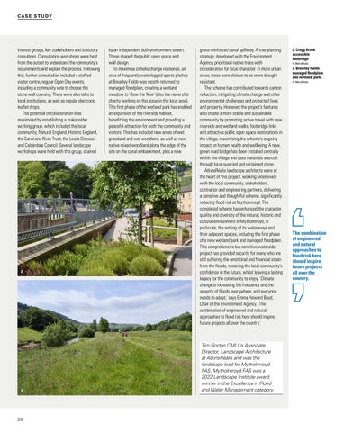
by an independent built environment expert. These shaped the public open space and wall design. To maximise climate change resilience, an area of frequently waterlogged sports pitches at Brearley Fields was mostly returned to managed floodplain, creating a wetland meadow to ‘slow the flow’ (also the name of a charity working on this issue in the local area). This first phase of the wetland park has enabled an expansion of the riverside habitat, benefitting the environment and providing a peaceful attraction for both the community and visitors. This has included new areas of wet grassland and wet woodland, as well as new native mixed woodland along the edge of the site on the canal embankment, plus a new
grass-reinforced canal spillway. A tree planting strategy, developed with the Environment Agency, prioritised native trees with consideration for local character. In more urban areas, trees were chosen to be more drought resistant. The scheme has contributed towards carbon reduction, mitigating climate change and other environmental challenges and protected lives and property. However, the project’s features also create a more stable and sustainable community by promoting active travel with new riverside and wetland walks, footbridge links and attractive public open space destinations in the village, maximising the scheme’s ongoing impact on human health and wellbeing. A new, green road bridge has been installed centrally within the village and uses materials sourced through local quarried and reclaimed stone. AtkinsRéalis landscape architects were at the heart of this project, working extensively with the local community, stakeholders, contractor and engineering partners, delivering a sensitive and thoughtful scheme, significantly reducing flood risk at Mytholmroyd. The completed scheme has enhanced the character, quality and diversity of the natural, historic and cultural environment in Mytholmroyd, in particular, the setting of its waterways and their adjacent spaces, including the first phase of a new wetland park and managed floodplain. This comprehensive but sensitive waterside project has provided security for many who are still suffering the emotional and financial strain from the floods, restoring the local community’s confidence in the future, whilst leaving a lasting legacy for the community to enjoy. 'Climate change is increasing the frequency and the severity of floods everywhere, and everyone needs to adapt,' says Emma Howard Boyd, Chair of the Environment Agency. 'The combination of engineered and natural approaches to flood risk here should inspire future projects all over the country.'
Tim Gorton CMLI is Associate Director, Landscape Architecture at AtkinsRéalis and was the landscape lead for Mytholmroyd FAS. Mytholmroyd FAS was a 2022 Landscape Institute award winner in the Excellence in Flood and Water Management category.
2. Cragg Brook accessible footbridge © AtkinsRéalis
3. Brearley Fields managed floodplain and wetland ‘park’. © AtkinsRéalis
The combination of engineered and natural approaches to flood risk here should inspire future projects all over the country.