The Tumwater Hospital That Never Was Thurston County Pioneer, Teacher and Community Activist: The Life of Ada Sprague Mowell The Port Townsend Southern Railroad Early Washington Records from Oregon $5.00 Number 5 April 2018

The Thurston County Historical Journal is dedicated to recording and celebrating the history of Thurston County. The Journal is published by the Olympia Tumwater Foundation as a joint enterprise with the following entities: City of Lacey, City of Olympia, City of Tumwater, Daughters of the American Revolution, Daughters of the Pioneers of Washington/Olympia Chapter, Lacey Historical Society, Old Brewhouse Foundation, Olympia Historical Society and Bigelow House Museum, South Sound Maritime Heritage Association, Thurston County, Tumwater Historical Association, Yelm Prairie Historical Society, and individual donors.
Publisher
Olympia Tumwater Foundation
John Freedman, Executive Director
Lee Wojnar, President, Board of Trustees 110 Deschutes Parkway SW P.O. Box 4098
Tumwater, Washington 98501 360-943-2550
Editor
Karen L. Johnson 360-890-2299
Karen@olytumfoundation.org
Editorial Committee
Drew W. Crooks
Janine Gates
James S. Hannum, M.D.
Erin Quinn Valcho
The Journal welcomes factual articles dealing with any aspect of Thurston County history. Please contact the editor before submitting an article to determine its suitability for publication. Articles on previously unexplored topics, new interpretations of well-known topics, and personal recollections are preferred. Articles may range in length from 100 words to 10,000 words, and should include source notes and suggested illustrations.
Submitted articles will be reviewed by the editorial committee and, if chosen for publication, will be fact-checked and may be edited for length and content. The Journal regrets that authors cannot be monetarily compensated, but they will gain the gratitude of readers and the historical community for their contributions to and appreciation of local history.
Opinions expressed by contributors are not necessarily those of the Olympia Tumwater Foundation
Written permission is required to reproduce any part of this publication. Copyright © 2018 by the Olympia Tumwater Foundation. All rights reserved. ISSN 2474-8048
Number 5
April 2018
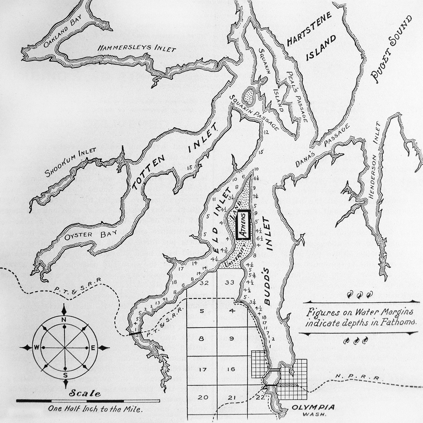
2 Shifting Patterns of Prejudice: The Story of a Native American House Post
Drew Crooks
14 The Tumwater Hospital That Never Was
Richard McCartan
21 Thurston County Pioneer, Teacher and Community Activist: The Life of Ada Sprague Mowell

Jennifer Crooks
34 The Port Townsend Southern Railroad
James S. Hannum, M.D.
51 Early Washington Records from Oregon
Karen L. Johnson
Back Cover
Who/What/Where Is It?
Megan Ockerman
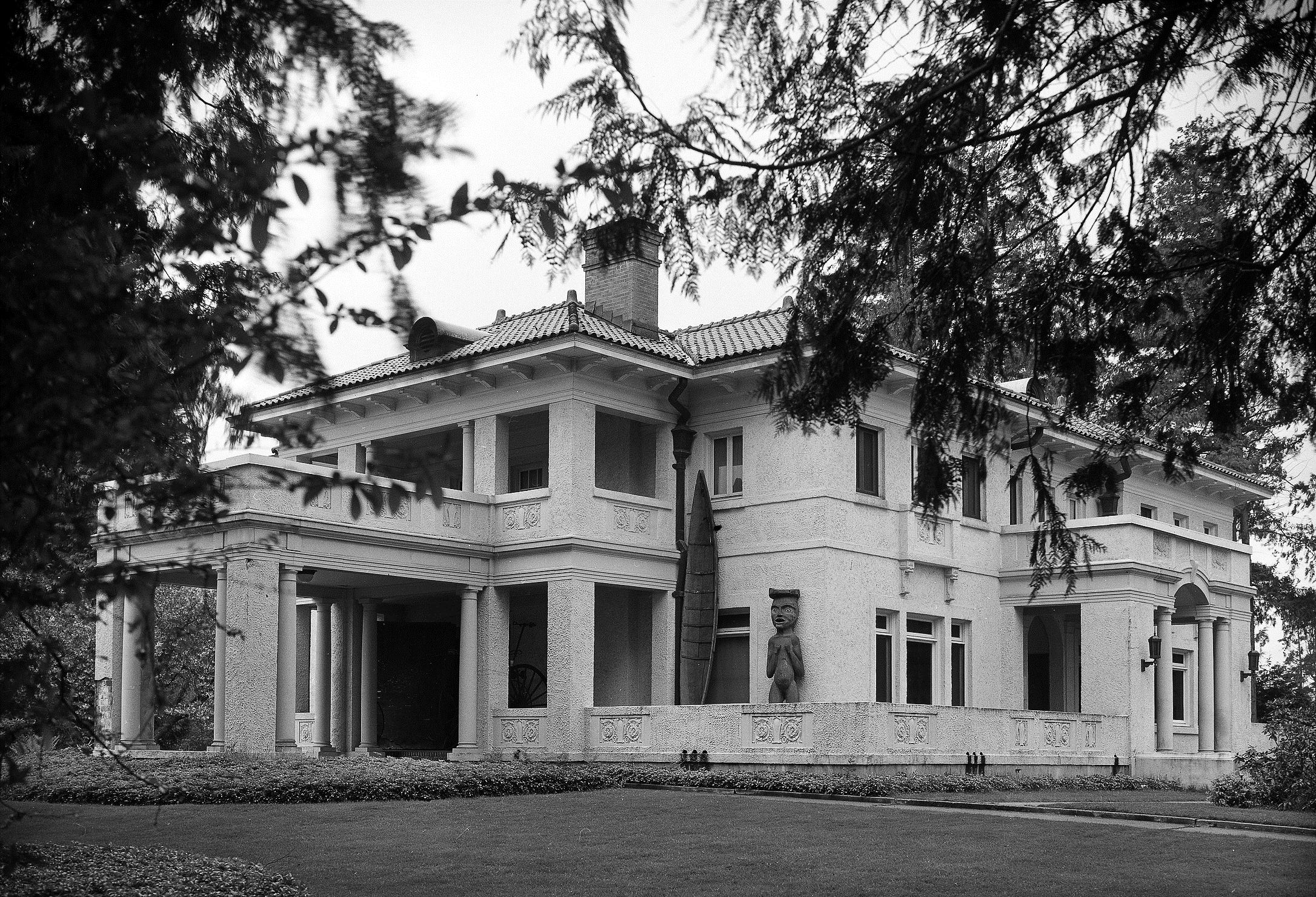
On the cover: From 1972 to 1992, a Native American house post boldly stood in front of a Nuu-chah-nulth (or Nootka) house screen on the second floor of the Washington State Capital Museum as part of a long-term display. Photo courtesy of Drew Crooks. See article on page 2.
This article traces the unusual journey through space and time of a Native American house post from its origins in a Native village to becoming part of a museum collection. The object’s history vividly shows the shifting patterns of prejudice in the Olympia community.
First it is necessary to briefly look at the traditional cultures of the North Pacific Coast from where this house post originated. The Northwest Coast Native societies had social classes, including chiefs, commoners, and slaves. Chiefs inherited economic and ceremonial rights. Anthropologist Philip Drucker in his classic study titled The Northern and Central Nootkan Tribes stated it well:
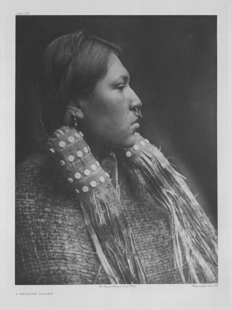
Northwest Native American societies traditionally included chiefs, commoners and slaves. This photograph, taken by Edward Curtis in 1910, shows a Hesquiat woman of high rank. The Hesquiat form part of the Nuu-chahnulth (or Nootka) Nations on the west coast of Vancouver Island. Photo courtesy of Wikimedia Commons.
“The real fountainhead of chiefly power is clear. Whatever authority a chief had derived in final analysis from the various rights he had inherited. The head chiefs, the ‘real chiefs,’ were those who held the most, the lower chiefs, those who owned less, and commoners were simply people who possessed none at all. The Nootkans carried the concept of ownership to an extreme. Not only rivers and fishing
places close at hand, but the waters of the sea for miles offshore, the land, houses, carvings on a house post, the right to marry in a certain way or the right to omit part of an ordinary marriage ceremony, names, songs, dances, medicines, and rituals, all were privately owned property.”1
Thus the “carvings on a house post” represented inherited chiefly privileges. These house posts physically supported the central ridge pole of a winter longhouse. They were a type of totem pole, but differed from house frontal poles, memorial or commemorative poles, and welcome figures. In Native society what was important about house posts was not the actual poles themselves, but the inherited rights to display them along with accompanying stories. Certainly the poles were not in any way considered idols or gods in the sense of being worshipped as some uninformed nonNatives believed.
This article will focus on one Native American house post that came to Olympia in the late 19th Century. There are three different accounts of its origins. One story is that Olympians acquired this post in 1863 on the Queen Charlotte Islands (now known as Haida Gwaii).2 However, the carving is clearly not Haida in style.3
“At some time this god occupied a proud location on a river bank in the far north. Owing to years of erosion of the bank the god was undermined and fell into the river, which carried him on to the sea, and there he took a southerly course until he was picked up in the Straits of Juan de Fuca by a sea captain and by him sent to a saloon keeper in Olympia.”4
This was the story taught to visitors to the Washington State Capital Museum in the 1960s and 1970s.5 It is dramatic, but is it true? How could an interior house post leave its Winter House and fall into a river? Possible, but not very likely.
The last account of the house post’s origin seems more likely to be true. An article published in the Morning Olympian on October 19, 1901, related the following tale: “This old totem pole has a history familiar to old-timers. It was formerly an idol in the possession of the Macah [Makah] tribe of Neah bay Indians. In the early seventies it was surreptitiously removed from Neah bay and came into possession of Frank Guttenberg. . .”6
Another more popular origin account was related by George E. Blankenship in his 1923 book Lights and Shades of Pioneer Life on Puget Sound:
Thus it is quite possible that the post came from the Makah Tribe. The carving is in the Makah/Nuu-chahnulth style.7 The Makah of Neah Bay are linguistically and culturally related to the Nuu-chah-nulth (or Nootka) people of Vancouver Island’s West Coast. A closer look at Makah house posts of the mid-19th Century is necessary to better understand the
situation. Fortunately, the records of early anthropologist James G. Swan shed a powerful light on 19th Century Makah culture including house posts. Indeed, on March 20, 1861, Swan drew a sketch of a Makah winter house with carved house posts. Currently, this drawing is preserved in Yale University’s Beinecke Rare Book & Manuscript Library.8
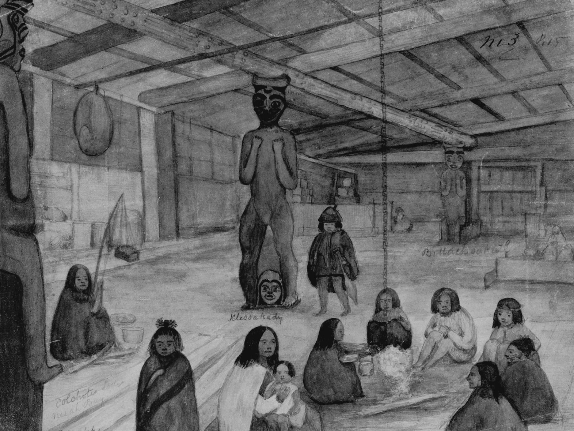
This house in Neah Bay belonged to Colchote, a descendent on his mother’s side from Deeart [or Deeah], founder of the village. The hereditary chief was appointed a sub-chief by Governor Isaac Stevens and participated in the January 1855 Treaty Council of Neah Bay. In fact his signed “X” was second on the list of Native American signers.9 The old chief died,
In the 19th Century, James Swan preserved much information about the Makah Native people at Cape Flattery. His 1861 drawing of “Colchote’s Lodge, Neeah [Neah] Bay” records the interior of a Makah chief’s house, including carved house posts. Photo courtesy of Beinecke Rare Book & Manuscript Library, Yale University.
as recorded in James Swan’s diary, on January 20, 1863.10
The house posts in Colchote’s lodge that were recorded by Swan are most interesting. At the least, they are very similar to the house post that later came to Olympia. James Swan was fascinated by the carvings of Colchote and described them in his 1870 book titled The Indians of Cape Flattery:
“In one of the lodges at Neeah Bay are three carved figures, on whose heads rests the huge beam that supports the roof; of these one is intended to represent Deeahks, or Deeaht. Another figure, in the centre, is named Klessakady, and is symbolical of sunrise. His head is surmounted with a crescentshaped cap, and between his feet is a head representing night. The beam above is marked with circular holes, to represent stars, and according to Kalchote, the old chief, who placed it there, it may be said to show the manner in which the sun, when rising, thrusts the stars away with his head and tramples the night under his feet. A figure at the remote end of the lodge is named Billaksakut’hl, and represents a fabled giant of antiquity, who could spread his feet apart, leaving a space between his legs wide enough to pass the largest canoes through. These are the only carvings of any note in the village. . .”11
These stories recorded by Swan give Native meaning to the sculptures. Unfortunately, Swan in his writings casts doubt on the oral history. He did
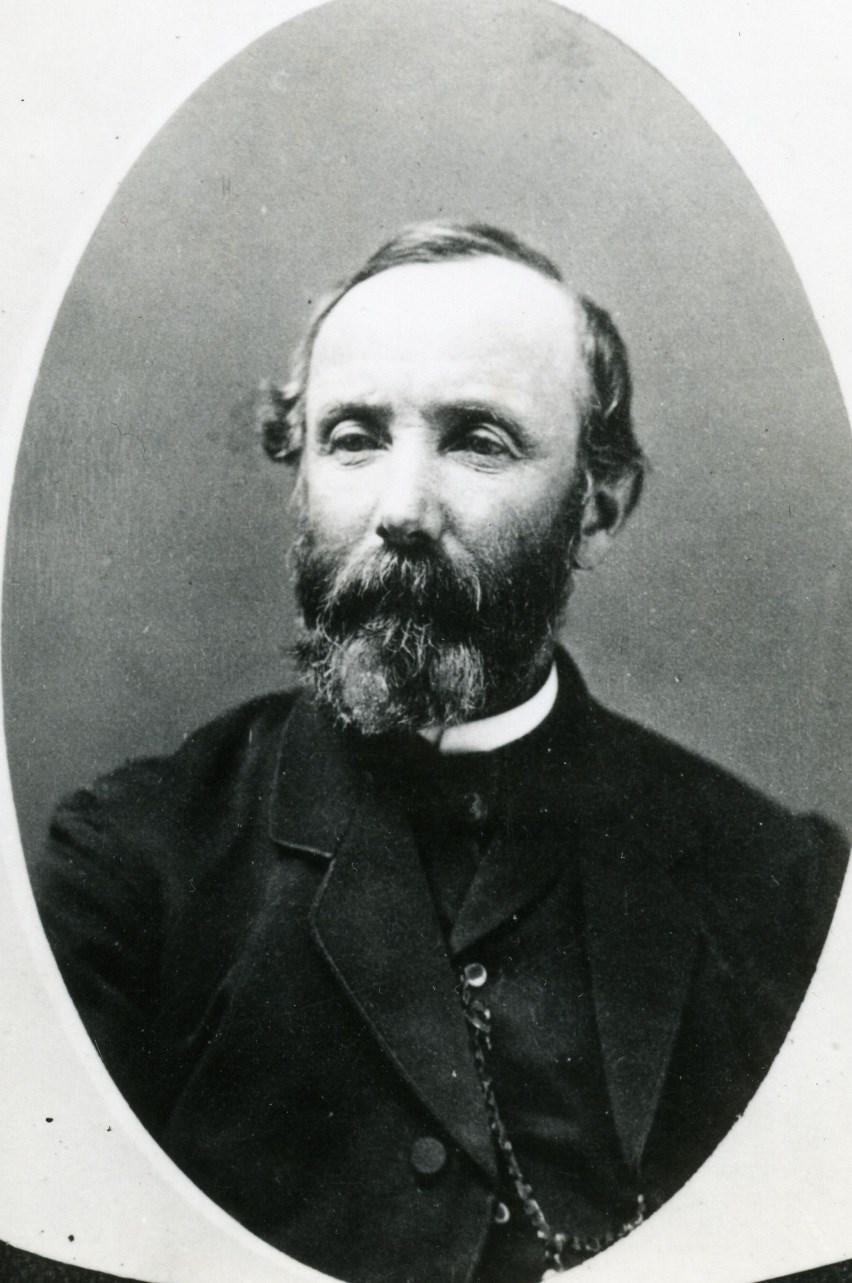
James Swan (1818-1900) wrote extensively about Native American and American settler life in Washington Territory and State. One of his noted publications was The Indians of Cape Flattery. Photo courtesy of Washington State Archives, State Library Photograph Collection, 1851-1990.
not have a good translator when collecting information about the posts and encountered skepticism from other Makah Indians concerning the tales.12 But if the posts represented inherited privileges and showed family stories, would not Colchote be the authority on their meaning? In any case,
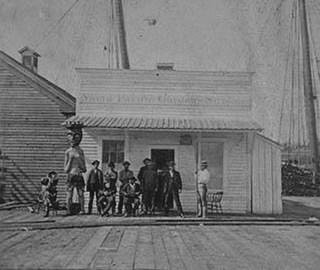
For several years the Native house post was attached to the North Pacific Gardens Saloon in Seattle before coming to Olympia in the early 1870s. An 1872 stereoscopic photograph by George Moore shows the saloon and post. Photo courtesy of University of Washington Special Collections, Negative Number NA 1490.
Swan recorded that a Nitinaht Indian artist from Vancouver Island carved the Deeah post, a Makah slave named Dick sculpted the Klessakady post, and the old chief himself shaped the Billaksakut’hl post.13
Some specific evidence does exist concerning the Native American house post that came to Olympia. A stereoscopic view by photographer George N. Moore in the University of Washington Special Collections certainly shows the house post in question.14 The post is
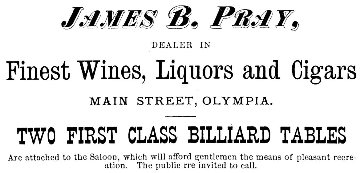
James Pray owned the Native American house post in the 1870s. He kept it in the alleyway next to his saloon in downtown Olympia. This advertisement for Pray’s establishment appeared in the 1872 Puget Sound Directory and Guide to Washington Territory. Image courtesy of Washington State Library.
helping to hold up the roof of the North Pacific Gardens Saloon on Yesler’s wharf in Seattle in Washington, 1872. In the background the masts of a sailing ship can be seen.
In 1872 Frank Guttenberg owned the North Pacific Gardens Saloon. The same 1901 Morning Olympian article which stated the house post was stolen from the Makah also recorded that the carving “came into possession of Frank Guttenberg, a Seattle saloon man who was [a] considerable . . . character in early days on Yesler’s wharf and his resort was a ‘hang-out’ for many Olympians in those times.”15 Incidentally, the house post in the stereoscopic view is wearing some sort of loin cloth. In its later history the post had no need to wear such an outfit. Obviously, it had been recarved to make it more presentable to 19th Century American society.
The post was brought to Olympia in the early 1870s. Two surviving stories explain the move. One tale recounted that the carving had to go because it scared a pregnant woman in Seattle. Another account related that Guttenberg was tricked into sending the post to Olympia by the false promise of a government job. Neither story can be proved.
For a number of years the Native American house post in Olympia was associated with James Pray’s saloon, which stood on the east side of Main Street between 3rd and 4th. Today that would be Capitol Way between State and 4th Avenues. Currently the site is a parking lot. The Indian carving in the 1870s was placed in the alleyway running alongside the saloon. Many stories have been told about the house post at Pray’s saloon. They include accounts about the post scaring a drunk so much that he swore to quit drinking, and disrupting a Christian baptism ceremony in Budd Inlet. Another tale was reported by George E. Blankenship in a July 1921 Morning Olympian newspaper article:
“Hurriedly entering the saloon early one winter evening, a man announced that a body had just floated under the Marshville (west side) bridge and was going out with the ebb tide. These men answering to [the] kindly impulse
characteristic of the pioneer, put on overcoats, and with lanterns faced a wet and windy night on the bay. In their hurry they failed to notice the absence of Mr. Totem from the back door of the saloon. Later in the night, a procession headed by six men bearing upon their shoulders the recreant northern god entered Mr. Pray’s saloon preceded by an artist with a mouth organ giving forth the dolorous tones of Chopin’s Funeral March.”16
One fact is certain. The house post at this time was surrounded by strong prejudice against Native Americans. There was little respect for the house post or appreciation of its cultural heritage.
James Pray died in Olympia on December 13, 1877. Two men from the community, Charles Grainger and Robert Frost, served as administrators of his estate. Evidently, the Native American house post passed into the hands of Grainger. This American settler came to Olympia in the early 1850s, fought in the Puget Sound Indian War, and served as the hangman for Leschi, the famous Nisqually leader. For seven years Grainger operated an Olympia-Monticello stage line with L. A. Davis, and ran a livery in Olympia. In any case, Grainger kept the house post at his stable or an attached skating rink between 5th and 6th Streets on the east side of Main Street. Currently that would be between 5th Avenue and Legion Way on Capitol Way. The site is presently a Batdorf and Bronson coffeehouse.
Later the house post was stored at Percival’s wharf, a steamboat dock built along State and Water in 1891. This wharf was torn down in 1977 and Percival Landing has since been built there. It is no coincidence that at the turn of the 20th Century the Native carving went to Percival’s dock. Charles Grainger’s daughter, Elizabeth, married John C. Percival who was in charge of the dock for many years.
In 1899 the house post temporarily came out of storage as part of a strange rivalry between Olympia and Seattle. On October 18 of that year a totem pole stolen from the Tlingit village of Tongass in Alaska was unveiled in Seattle’s Pioneer Square to public acclaim. For some reason the Seattle pole and its accompanying celebration ruffled the feathers of some people in Olympia.
This resulted in a flurry of editorials in Olympia newspapers claiming that the Capital City’s house post was just as good as the pole in Seattle. In fact, Olympia zealots for a brief time displayed the post at Sylvester Park, with the carving fastened to the bandstand by a wire. Unfortunately, the editorials were full of anti-Indian racism.
For example, a crude racist poem was published in the Morning Olympian issue of November 22, 1899, which included the verses:
“You’re not the only iceberg In the floe.
Yes, Olympia, too, Has got a pole, A weird phantasmagoria Of Indian diabolism, Grotesquely carved And e’en more crosseyed, . . .”17
This was not exactly a shining example of multicultural understanding. The post soon returned to storage at Percival’s wharf. Charles Grainger died on his farm a few miles south of Olympia on January 30, 1906.
of the local Auto Dealers association, repainted the carving. It was placed in Priest Point Park. A Morning Olympian article of August 1921 observed: “That historic and justly famous Olympia totem pole, all repainted in every hue of the rainbow from the artist brush of Milo Morris, is now at last at rest in an imposing place in Priest Point park.”18 In 1923 the carving was moved “to one of the vantage points just inside the Park to be where every park visitor can see it on entering.”19 Among some young people of the time the pole was known as “The Monster of the Park.”20
On June 2, 1942, the newly formed Washington State Capital Museum made a request to the City of Olympia “that the Indian idol at Priest Point park be turned over by the city for display and safekeeping at the museum.”21 The City Commissioners passed the request on to the Commissioner of Public Works “with the power to act.”22 So the carving was transferred to the Museum (located at 211 - 21st Avenue in southwest Olympia).
A Tlingit totem pole, seen in this circa 1911 photo, was installed in Seattle’s Pioneer Square in 1899. The event evoked jealous responses from some Olympia residents. Photo courtesy of University of Washington Special Collections, Neg. No. Warner 3018.
For years the house post stood outside the old Lord Mansion which served as the main Museum building. An April 1961 photograph by Merle Junk from the Susan Parish Collection of the Washington State Archives showed the carving standing next to the Museum.23 Later in the 1960s, the house post was transported to the lower floor of the Museum where it
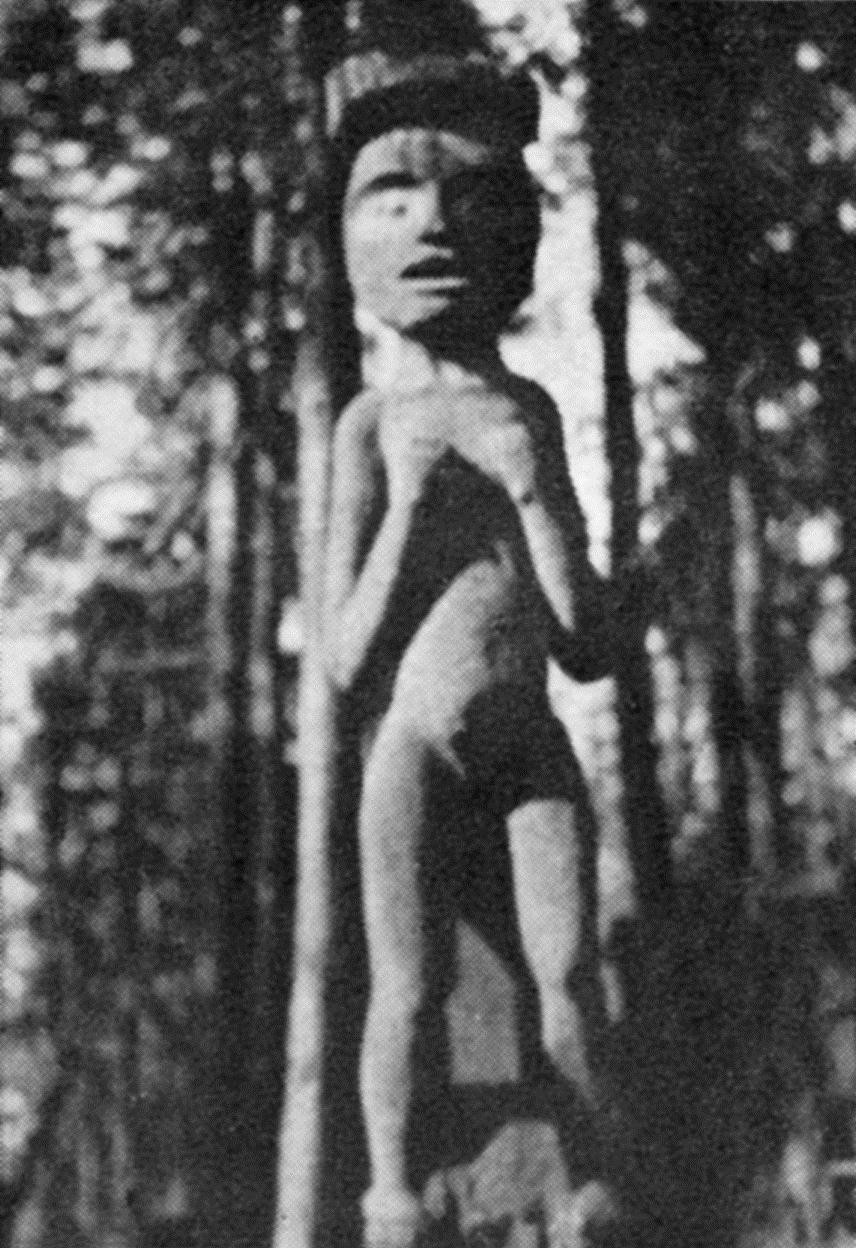
For over twenty years, from 1921 to the early 1940s, the Native American house post stood at Priest Point Park in Olympia. In 1937, Olympia High School’s annual yearbook, the Olympus, featured a picture of the carving at the park. Photo courtesy of Washington State Library.
McBride recognized that the piece was an important artifact which deserved a more prominent position at the Washington State Capital Museum. As part of a massive exhibits reorganization, the carving was moved to the Museum’s second floor, and stood in front of a Nuu-chah-nulth (or Nootka) painted screen at the entry to a new Indian display area. The following twenty years were a golden era for the carving. It received respect, being recognized as a key artifact in the Museum’s collection. For a time, in the 1980s, its image was even the logo on the Museum’s newsletter “Musings.”25 Some staff members affectionately gave the post the nickname of “Woody.”26
became a favorite display for visitors. Examples of stories written by students about the impressive carving are preserved in the Washington State Capital Museum scrapbooks.24
Then in April 1972 came a turning point for the house post. Curator Del
Life is full of change. In 1992 the house post was taken down for a new long-term Native American exhibit called “Traditions and Transitions: American Indians of Southern Puget Sound.” The post was put into storage at The Evergreen State College; the staff hoped that the carving would be displayed in the College’s Longhouse Education and Cultural Center which opened in 1995.27 That was not to be. The post continued to be stored at Evergreen for a time. Then after the merger of the Washington State Capital Museum with the Washington State Historical Society, it was taken to Tacoma where it remains in storage.
The story of this Native American house post reveals the shifting patterns of prejudice in Olympia from
raging anti-Indian racism in the late 19th and early 20th Centuries to a more sympathetic attitude of the last 40 years. Del McBride of the Washington State Capital Museum helped facilitate that change in our community, as demonstrated by moving the house post from the Museum’s basement to the prominent second floor.
Perhaps now is the time for the Native American house post to make one more move. Repatriation of the pole to
the Makah Tribe, from whom it was most likely stolen in the 19th Century, would right an old wrong and contribute to the cultural life of the Makah people. The pole would finally be at home again. NOTES
The Native American house post was displayed for several decades outside Olympia’s Washington State Capital Museum building. This situation is depicted in an April 1961 photograph taken by Merle Junk. Photo courtesy of Washington State Archives, Susan Parish Collection.
1951, page 247.
2 “Speaking of Totem Poles.” Olympian, Olympia, WA, November 22, 1899, page 3.
3 For Haida sculpture style, see Bill Holm, “Art,” in Wayne Suttles, edited, Handbook of North American Indians, Volume 7 Northwest Coast. Washington, DC: Smithsonian Institution, 1990, pages 615-616.
4 George E. Blankenship, Lights And Shades Of Pioneer Life On Puget Sound. Olympia, WA: unknown publisher, 1923, page 53.
5 Observations of the author in the 1960s and 1970s at the Washington State Capital Museum and conversations with Museum staff.
6 “Getting Back At Seattle.” Morning Olympian, Olympia, WA, October 19, 1901, page 3.
7 For Nootkan (or Nuu-chah-nulth) sculpture style, see Holm, “Art,” in Suttles, pages 618-619.
8 James Swan’s drawing of “Colchote’s Lodge. Neeah Bay,” March 20, 1861, is illustrated in George A. Miles, James Swan, Cha-Tic of the Northwest Coast: Drawings And Watercolors From The Franz & Kathryn Stenzel Collection Of Western American Art. New Haven, CT: The Beinecke Rare Book & Manuscript Library, Yale University, 2003, page 81.
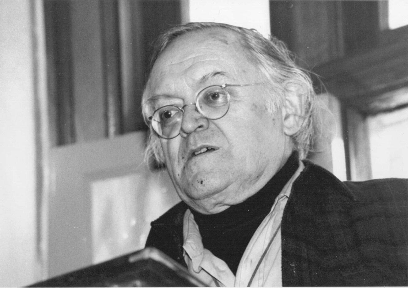
Delbert McBride, seen in this 1992 portrait, served as Curator of the Washington State Capital Museum from 1966 to 1980. In 1972 he had the museum’s Native American house post moved from the basement to a prominent position on the second floor. Photo courtesy of a private collection.
9 The Makah leader’s name was listed as “Kal-chote”, “Treaty With The Makah, 1855,” in Charles J. Kappler, compiled and edited, Indian Affairs: Laws And Treaties, Volume II Treaties. Washington, DC: Government Printing Office, 1904, page 684.
10 Lucile McDonald, Swan Among the Indians: Life of James G. Swan, 18181900. Portland, OR: Binfords & Mort, Publishers, 1972, page 103.
11 James G. Swan, The Indians Of Cape Flattery, At The Entrance To The Strait Of Fuca, Washington Territory.
Washington, DC: Smithsonian Institution, [1870], page 59.
12 Miles, pages 23-24.
13 Miles, page 24.
14 “Carved totem outside saloon on Yesler’s wharf, Seattle, Washington, 1872,” stereoscopic photograph. University of Washington Special Collections Division, George Moore collection No. 281, Negative Number NA 1490.
15 “Getting Back At Seattle.” Page 3.
16 “Totem Pole to Adorn Park Has Wierd [sic] Story.” Morning Olympian, Olympia, WA, July 3, 1921, page 4.
17 “Speaking Of Totem Poles.” Page 3.
18 “Totem Pole Now In Full Glory Erected In Olympia’s Park.” Morning Olympian, Olympia, WA, August 5, 1921, page 1.
19 “Moving Ahead With Plan To Develop Park.” Morning Olympian, Olympia, WA, March 24, 1923, page 4.
west Regional Branch, Washington State Archives, Olympia, Washington, accession 92SW6.
22 Olympia Municipal Government, City Clerk, Minutes, page 586.
23 Washington State Capital Museum, April 1961, photograph by Merle Junk, Susan Parish Collection, Washington State Archives, Olympia, Washington.
24 Washington State Capital Museum scrapbooks, Washington State Historical Society Research Center, Tacoma, Washington.
25 Washington State Capital Historical Association, Musings newsletter, June 1984 – January/February 1989.
26 Personal observations of author, who served as Curator of Collections at the Washington State Capital Museum from 1984 to 1997.
27 Personal observations of author.
20 Roger Easton. Interview by author. Olympia, 2010. As a child, historian Easton saw the house post at Priest Point Park.
21 Entry for June 2, 1942, Olympia Municipal Government, City Clerk, Minutes, Volume 17 (May 10, 1938 –December 29, 1942), page 586. South-
Drew Crooks earned a bachelor’s degree in history and anthropology and a master’s degree in museum studies from the University of Washington. For over 30 years he has worked with various museums in South Puget Sound, and has written a number of articles and books on the region’s heritage.
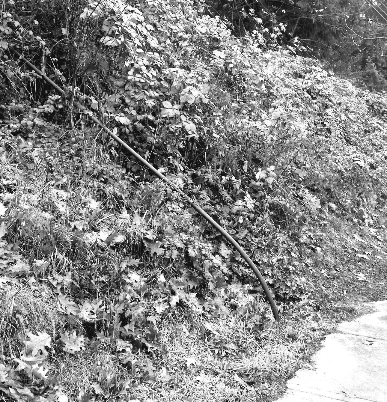
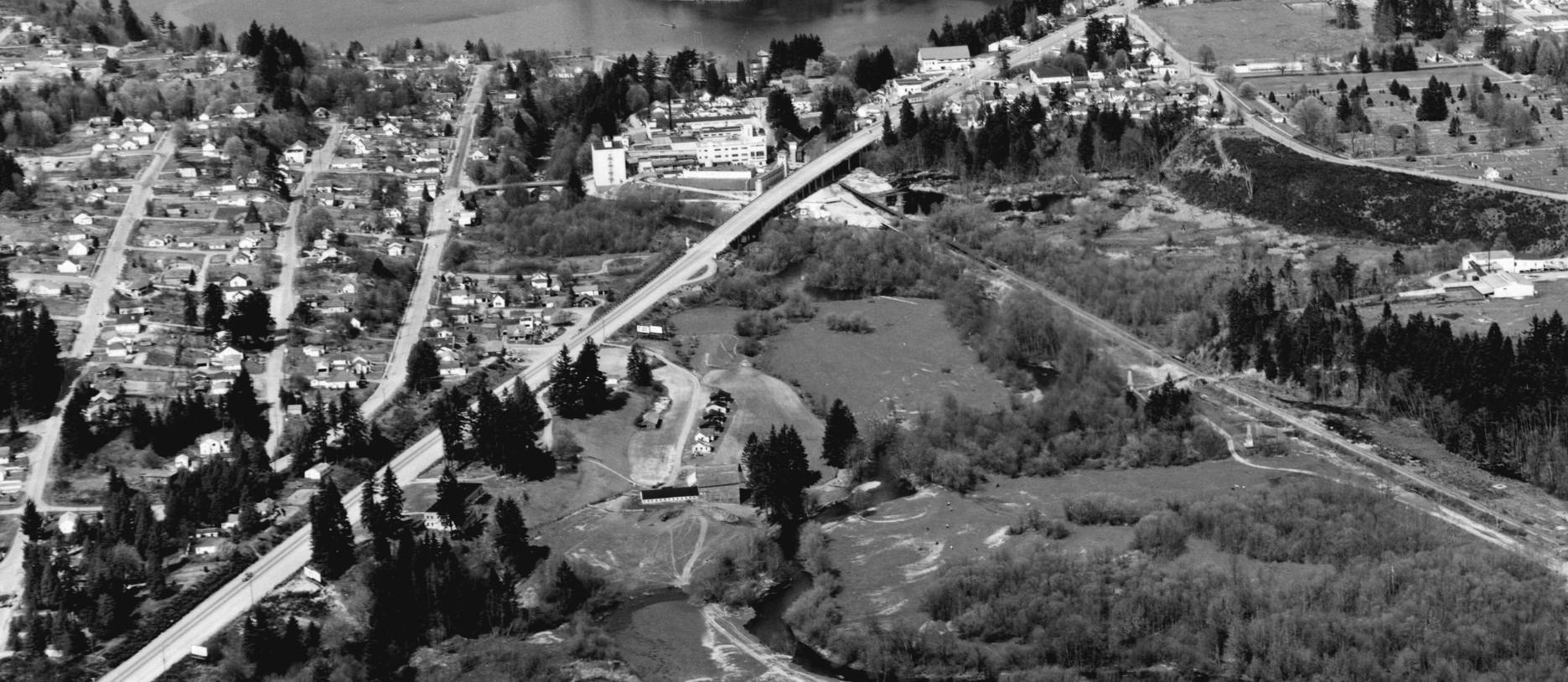
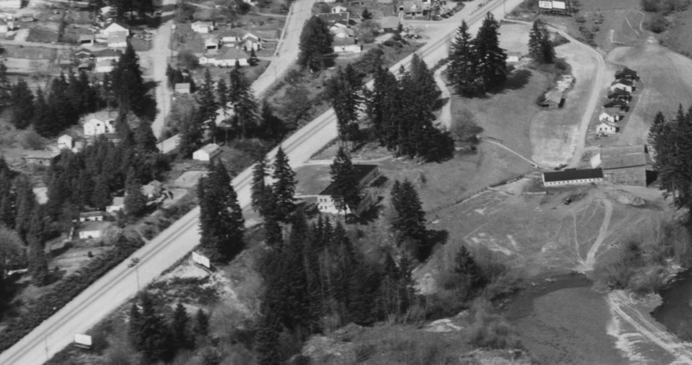
A rusty stair rail, leading nowhere and choked by weeds, stands along Capitol Boulevard just south of E Street, on the bluff overlooking the Tumwater Valley. The rail and stairs are the only remaining traces of a Tumwater mother’s remarkable plan for her son to return to his hometown to practice medicine.1
The mother was born Elizabeth Conrad in 1872 in Germany. She immigrated to the United States and in 1897, she married Emil Mathwig, a Polandborn boot maker, in King County,2 a second marriage for both. They went back to Europe, and re-entered the United States in 1907 through Ellis Island with two young children in tow: Ruth (age three) and Rolf (or Ralph, age two).3
This handrail and associated concrete steps are the only remnants of a hospital that once was under construction in Tumwater. 2017 photo courtesy of Karen L. Johnson.
In 1911, the couple had a third child, James Elmer, in Puyallup. They divorced, and Emil died in Tacoma in 1922.4 In 1923, at age 51, Elizabeth
purchased a dairy farm in the Tumwater Valley on property just east of Capitol Boulevard, which was Old Highway 99 back then.
At the time, Tumwater had only about 500 residents. In the first half of the 20th Century, the number of farms in Thurston County grew quickly, reaching 2,876 by 1940.5 Most families in rural areas had one or two cows to meet their own needs. Larger dairy farms, such as the Mathwig farm, served the needs of city dwellers.
James Elmer Mathwig graduated from Olympia High School in 1929.6 He graduated from the University of Washington with a Bachelor of Science degree in pharmacy in 1933.7 Subsequently, he graduated from the University of Oregon Medical School in 1937.8 He interned in Los Angeles, and practiced for a time in Colville, Washington, north of Spokane.9
By 1942, James was an Army captain stationed in Honolulu.10 In 1943, he received a meritorious conduct decoration for his service at the Battle of Guadalcanal, the Allies’ first major offensive against Japan and a turning point in World War II. As a combat battalion surgeon, he was recognized for saving lives in a unit less than 200 yards behind the front line.11 The Olympian reported that James created a “sensation around town” by sending a tattered Japanese flag to his married sister, Ruth McConkey.12
Meanwhile, back in Tumwater, Elizabeth had embarked on an ambitious
project along Capitol Boulevard: constructing a large concrete building that she hoped would eventually become a hospital managed by James. Ralph, who lived on the farm with his mother, did much of the work on the building. Elizabeth purchased some medical equipment for the hospital.
Elizabeth and Ralph testified about the project in a federal criminal case.13 The case arose in 1943 when Ruth became concerned about the welfare of her brother James’s two children. They were in their mother Margaret’s care in Portland while James was away at war. Ruth hired an Olympia private detective, Murrell F. Haid, to investigate the mother. Based on his dealings with the Mathwigs and several other persons, the government charged Haid with impersonating a federal agent.
At trial, Elizabeth testified that she showed Haid the partially-built hospital on their property. Elizabeth stated that Haid told her that he “could get the government to finish the hospital” so that James could come back to manage it. But Elizabeth replied that he could never convince James to return.
Ralph testified that the building had no finished rooms, no windows, and only a partial roof. When Haid claimed the government would be interested in owning the hospital, Ralph obtained a contractor’s estimate of $40,000-$50,000 to finish the work.
James never did return to Tumwater, and construction of the hospital building never resumed after the war. In a 1951 interview in The Olympian, an 80 -year-old Elizabeth explained that her abandoned hospital would be used for apartments.14
“So there the building stands, commanding a fine view of the DesChutes
River, of Tumwater, and of the Capitol Dome towering over Olympia,” wrote The Olympian. Elizabeth was philosophical about her change of plans. “Things come from every corner, and you can never tell what will happen,” she told the newspaper.
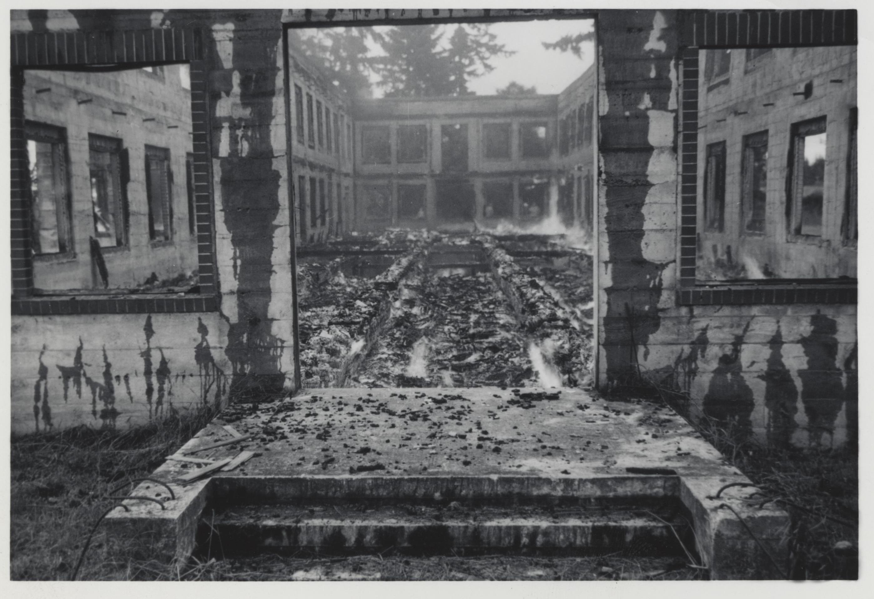
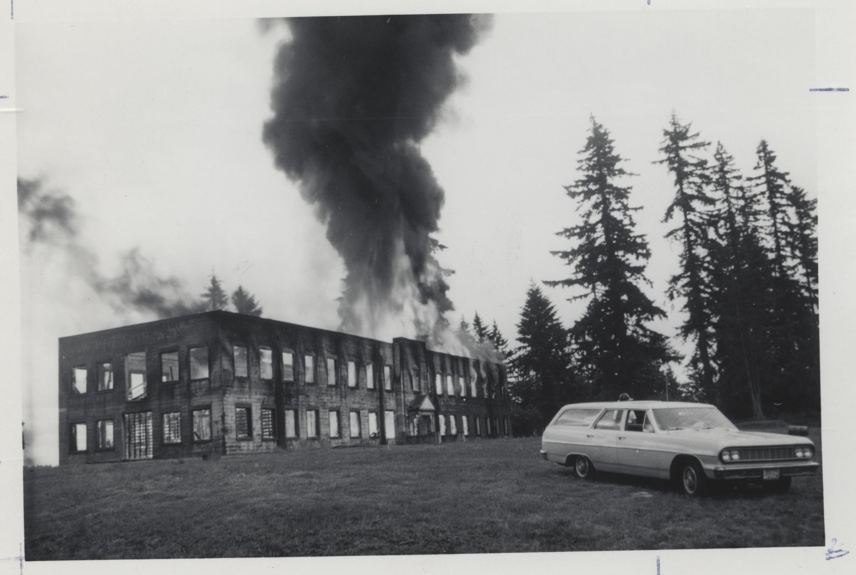
The apartment plan never got off the ground. Nor did an idea of using the building for a Tumwater City Hall.15 In 1959, Elizabeth sold her property to the Olympia Brewing Company for development of a golf course. Having no use for the building, the company allowed the Tumwater Fire Department to burn down the building in a training exercise in 1964,16 one year after Elizabeth died at age 91.
As for James, he and Margaret divorced in 1944.17 In 1949, he joined the clinical staff of the University of Washington Medical School,18 and was director of anesthesiology at Seattle’s Harborview Hospital. In 1954, he served as president of the Washington State Society of Anesthesiologists.
James also pioneered the use of dextran in the treatment of shock patients. He discovered that dextran raised blood pressure more quickly than conventional blood transfusions.19 He died in 1988 at age 77,20 survived by his second wife and two children, and leaving nearly his entire estate to Children’s Hospital in Seattle.
Providence St. Peter would remain Thurston County’s only hospital until Capital Medical Center opened on
Olympia’s west side in 1985. Elizabeth is buried at Mills & Mills Memorial Park in Tumwater. Her tombstone inscription reads “Our Beloved Mother. Rest In Peace.” A single parent and dairy farmer who aspired to build a community hospital for Tumwater, she should be remembered for her remarkable spirit.
61903/1:1:NQMW-JY9: 10 March 2018, Emil Mathwig, 01 Mar 1922; citing Tacoma, Pierce, Washington, reference 211, Bureau of Vital Statistics, Olympia; FHL microfilm 1,992,969 (accessed March 26, 2018).
5 Phil Dougherty, “Thurston County Thumbnail History.” Essay 7979. HistoryLink.org, http://www.historylink. org/File/7979 (accessed December 19, 2017).
1 Today, the old hospital property borders an area being used for construction of the Tumwater Craft Brewing and Distilling Center, a project spearheaded by South Puget Sound Community College and the City of Tumwater.
2 “Marriage Records from King County 1860-1898,” Genealogy Trails. http:// genealogytrails.com/wash/king/ marriage/1860mara.html (accessed December 19, 2017).
3 “New York Passenger Arrival Lists (Ellis Island), 1892-1924,” database with images, FamilySearch. https:// www.familysearch.org/ark:/61903/1: 1:JXK5-GZV: 30 January 2018, Emil Mathwig, 1907 (accessed March 26, 2018).
4 “Washington Death Certificates, 1907-1960,” database, FamilySearch, https://familysearch.org/ark:/
6 “High School to Graduate 158 Seniors Here June 6.” Morning Olympian, May 17, 1929, page 1.
7 “University of Washington graduates.” Seattle Daily Times, June 11, 1933, page 19.
8 “Elmer Mathwig Will Get Medical Degree.” Morning Olympian, May 21, 1937, page 7.
9 “United States Census, 1940,” database with images, FamilySearch, https://familysearch.org/ark:/61903/
1:1:K9S2-WZJ, James Elmer Mathwig, Colville, Colville Election Precinct 2, Stevens, Washington, United States, citing enumeration district (ED) 33-20, sheet 1B, line 59, family 28, Sixteenth Census of the United States, 1940, NARA digital publication
T627. Records of the Bureau of the Census, 1790-2007, RG 29. Washington, D.C.: National Archives and Rec-
ords Administration, 2012, roll 4364 (accessed March 26, 2018).
10 “Promoted.” Morning Olympian, June 14, 1942, page 12.
11 “Fighting Physician.” Morning Olympian, September 16, 1943, page 1.
12 “Ex-Weapons.” Morning Olympian, July 19, 1943, page 1.
13 No. 15668, United States of America, Plaintiff, vs. Murrell F. Haid, Defendant, 1945. https://archive.org/ stream/govuscourtsca9briefs2423/ govuscourtsca9briefs2423_djvu.txt
(accessed December 19, 2017).
14 “And You Never Can Tell What Will Happen.” Morning Olympian, March 4, 1951, page 1.
15 City of Tumwater, City Council Minutes, March 31, 1964. https:// web.ci.tumwater.wa.us/weblink/Doc View.aspx?id=4292&dbid=0 (accessed December 19, 2017).
16 “Burned Up and Torn Down.” It’s the Water News. Tumwater, WA: Olympia Brewing Company, September 1964.
17 “Divorces Granted.” Morning Olympian, April 2, 1944, page 8.
18 “200 Doctors Named To Clinical Staff Of U. W. Medical School.” Seattle Daily Times, June 19, 1949, page 44.
19 Harold F. Osborne, “Two Seattle Doctors Report Use of Blood Substitute Effective in Shock Cases.” Seattle
Daily Times, February 5, 1956, page 10.
20 “United States Social Security Death Index,” database, FamilySearch, https://familysearch.org/ark:/61903/ 1:1:J5CR-FT5: 19 May 2014, James E. Mathwig, 18 Oct 1988; citing U.S. Social Security Administration, Death Master File, database (Alexandria, Virginia: National Technical Information Service, ongoing) (accessed March 26, 2018).
Richard McCartan was born and raised in Pullman, and graduated from the University of Washington and Gonzaga Law School. He moved to Olympia in 1978, and was an Assistant Attorney General for 37 years, before retiring in 2017.
(Editor’s Note: The author refers to people in this article by their first names as a way to reduce confusion and does not denote any particular status.)
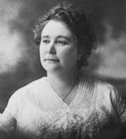
Ada Sprague Mowell (1867-1953) is an important figure in the history of Thurston County. As pioneer, teacher, and community activist, her actions helped shape the development of the region during the late 19th and early 20th centuries.
Ada was born in Ada County, Idaho, the seventh child and youngest daughter of Alfred D. and Wilhelmina (Sager) Sprague, on November 22, 1867.1 Her father had been born in Illinois to a family that had originally migrated from New England and her mother was from Germany. After their marriage, the growing Sprague family migrated steadily westward, seeking new opportunity. Alfred and Wilhelmina had a total of twelve children, whose birthplaces map the family’s westward migration over five states: three in Arkansas, two in Kansas, two in Colorado, one in Idaho (Ada), and two in Washington. The children that survived infancy were: Belle (Dodd), Olive, Etta (Gelbach),
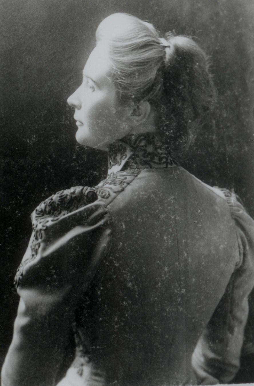
Ada Sprague Mowell as a young woman (no date). Photo from the Olympia Historical Society and Bigelow House Museum, Roger Easton Collection.
Hattie (Underwood), Ada (Mowell), Alice (Rabbeson), Oliver, Kate, Meda, Fred, and Roderick. Etta married
THURSTON COUNTY PIONEER, TEACHER AND COMMUNITY ACTIVIST: THE LIFE OF ADA SPRAGUE MOWELLJennifer Crooks
George Gelbach,2 who owned a gristmill at Tumwater Falls from the 1870s to around 1890.3
The Spragues and seven of their children (Belle married and stayed behind in Idaho) moved to Thurston County in December 1869 a long journey from Boise City to Olympia by wagon and foot. Ada was only two years old at the time. When they arrived in Olympia, they lived for a short time at what she referred to as “the old Hayden Place.” This house, torn down in 1946, was located on what is now Capitol Way between Tenth and Union Avenues.4
The family soon relocated to Tumwater, believing their prospects would be better in that area. They lived in the “old Barnes place” before moving to Bush Prairie and settling into the “Kuhn Place” before their homestead near Black Lake was fit for habitation. There was a lot of work to do to get the homestead ready, including clearing out the woods to build a large log cabin. Although things were not easy with building the farm and the untimely death of two of her teenage sisters Kate and Meda, Ada remembered her childhood fondly.5 In 1914, when interviewed for the Early History of Thurston County, Washington, Ada wrote that:
“While pioneer life was full of hardships for the elders it was full of joy for the youngsters. Looking back over our childhood, it seems like a long day of playtime. We had wonderful adventures in the woods
about the place. We built houses of round sticks of several stories for our dolls, which often were sticks themselves, or at best ‘rag dolls’. My first china doll was given me by a neighbor, Mrs. Harn, whose little girl had died. It was a precious possession, but never so dearly loved as my rag babies.”6
She also remembered much about what life was like in the early Tumwater area. She particularly liked her neighbors the Dittmans. Mrs. Dittman spoke only German and she loved to converse with Ada’s mother, who was German. 7 Ada also remembered:
“Mr. Benj[amin] Gordon’s place on Bush Prairie was always a joy to me. I know every nick of that orchard, and Mr. Gordon always treated me to big sticks of cinnamon bark. Jesse Ferguson’s farm was another place I loved to go. At threshing time my mother always helped the Ferguson girls cook for the threshers. Work was traded in these days and at log rolling time on our place the neighbors helped my mother. One of the sorrows of youth, that is still a regret, was a wonderful dinner I could not eat because of sickness, when there was a log rolling bee at our place.”8
Education had always been important to the Sprague family, despite the limited school resources in the area. When they lived on their homestead the family typically moved into Tumwater every winter for the school term of about six months. One
exception is the winter Ada attended the Central School in Olympia. Her father went out during the day to work at their dairy and the whole family returned in spring to work on the farm. During their stay in Tumwater they lived with local families such as the Brewers and Dudleys. Ada enjoyed Tumwater life, especially the annual community Christmas tree at the Christmas Eve service at a union church, which later became the Methodist Church on Tumwater Hill.9
Ada later remembered her school days with some mixed emotions:
“The school house on the hill, near the site of the present building, was a small one-room affair and to this day I remember my first appearance there. I was in deadly fear of the teacher, who taught with the rod ever in his hand. Later school was held in the Tumwater Literary Association Hall . . . . School was held in the lower floor and once when some of the older boys had planned to eject the teacher, during the scuffle which followed my sister, Etta, now Mrs. Gelbach of Spokane, put all we children out of the window and then clambered after us, whither most of the school followed. School in those days never lacked for excitement.”10
the family. Ada later stated that they lived on the land long enough to make the necessary improvements to gain ownership of their property under the Homestead Act11 and then moved into Tumwater.12 With her mother’s death in 1881 at the age of 48,13 Ada’s life changed again.
In 1883, at the age of fifteen, Ada became a teacher at Plum Station, a small community along the railroad line in central Thurston County. She had attended some high school and received additional training at the University of Washington, attending its normal (or teaching) program. For the next fifteen years, she taught in schools all over Western Washington, including Stuck in King County, Skagit City, Littlerock, Hoquiam, Tumwater, and Olympia. Many of her students remembered Ada as balancing good discipline with a sense of humor. For her “splendid service as a pioneer in the teaching profession,” she was made an honorary member in December 1947 of the Iota chapter of Delta Alpha Gamma, a professional honors society for women educators.14
When her father, worn down by the hard work of founding a farm in the wilderness woods, died in 1875, the family was left in difficult straits. The older children and widow took over care of the farm and family. Oliver left school and went to work to support
Ada spent the last two years of her career (1896-1898) as the principal of Lincoln School (which then consisted of first through eighth grades) in Olympia. It was a much smaller school than its modern offspring, Lincoln Elementary. Ada also taught a full load of classes, which she remembered put a strain on fulfilling her administrative duties. During this time she boarded with the McMicken family.15 While also serving as
principal, she was appointed by the Thurston County Superintendent of public schools to be on the Board of Examiners, a group that granted teaching licenses to teachers in the county.16
Ada was an adventurous person and in 1897, she climbed Mount Rainier as part of the first large Mazama Club sponsored climb. The Mazama Club is a mountaineering group, founded in 1894, that continues to the present. Ada’s story, recorded in the August 3, 1897 issue of the Morning Olympian, perhaps best sums up their adventure. Climbing the mountain was much harder in 1897 than today:
“A tired, jaded, happy party of mountain climbers it was that reached Olympia at noon today from a two weeks outing on Mount Rainier. Of this party, only three made the ascent to the summit of the mountain, namely Miss Ada Sprague, Mr. B. L. Hill and Dr. J. W. Mowell. This trio returns full-fledged members of the Mazama Club, and having the paste boards to show for it. The trip was a hard one, but was made without accident, so far as Olympians were concerned. And while none are sorry they made the trip, no one of them is anxious for an immediate return.
times. In fact, it is not recommended unless done in cold conditions before the sun hits the south face of the mountain because of loose rocks. The party hiked from Paradise valley to Camp Muir and stayed the night. They then climbed up the mountain.] Two hard days were spent by the Mazamas of the party in the ascent of the mountain, the goal being reached Tuesday evening last at about 4:40 o’clock. They remained on the summit only about 40 minutes, but that was
“They left Olympia Wednesday morning, July 22, and a week was spent in going to and returning from Paradise valley. [The party took the route through the Gibraltar Ledges, the route of the first climbers and the standard winter route in modern
quite long enough to nearly freeze to death. On the descent, the journey to Camp Muir was in company with Prof. McClure, who met death that night some distance further down the mountain [The party had split up into groups, and McClure had been acting as a scout. He fell and became the first recorded death of a mountain climber on Mount Rainier.] They started down to return to Camp Muir and brave the frigid temperatures for the night, which they did, fortunately.”17
On June 15, 1898, 30-year-old Ada’s life changed directions again upon her marriage to Dr. John Wilson Mowell, 37. It was a typical quiet wedding of the period, held at the home of her sister Etta. Etta, Ada’s future sister-in -law Laura Avery, her former landlord Mrs. McMicken, and the officiating minister were the only other people present.18
Dr. Mowell had climbed Mount Rainier with Ada in 1897.19 Born March 15, 1861 in Shamokin, Pennsylvania, John had grown up in Missouri. After graduating from high school at age seventeen, he taught four terms of public school. In 1882 he married America Feaster in Lincoln County. The couple moved to St. Louis where he worked as a shipping clerk at the Brownell and Wight Car Company and later the Brown Woodworking Company. He graduated from the Missouri Medical College (now part of Washington University) in St. Louis in 1888. The couple had two children: Shelley Earl Mowell (1884-1965), and
Arthur Ray Mowell (born in 1888) who tragically died of polio at the age of one. After John and America’s divorce, Shelley remained behind in Missouri with his mother while his father moved to Washington State. Later Shelley moved to Olympia to work as the Capital National Bank cashier and remained in the area the rest of his life.20
John moved to Tumwater in 1890, where his aunt lived, to start his own practice. For a while, he divided his medical practice between Tumwater and Olympia. Setting up office in the Reed Block, he spent the mornings in Olympia, afternoons in Tumwater, and answered night calls from Tumwater.21 The next year he discontinued his Tumwater office.22 Later, John was on staff at St. Peter Hospital. He was a member of the Thurston-Mason County Medical Society, state medical association, American College of Surgeons, and a representative member of the Eagles.
Mowell was also active in community affairs, serving as vice president of the Olympia National Bank from 1899 to 1906. He was elected to the Olympia City Council and was Olympia’s Health Officer.23 From 1896 to 1897 he served as Thurston County Physician.24 The doctor was also active in the movement for Industrial Insurance and was the first Medical Director of the Washington State Industrial Insurance board, serving from 1911 to 1917. He was Chairman of the State Medical Aid Board from 1917 to 1921. John maintained an
active medical practice until shortly before his death on July 7, 1925.25
After a wedding trip, the Mowells rented a duplex at 808 Main Street (now Capitol Way) in Olympia (next to the then-existing Masonic Temple). Ada quickly became active in the social life of the town.26 As a married upper-middle class woman with a relatively secure financial situation, she dedicated the rest of her life to the woman’s club movement of the time period and social reform.
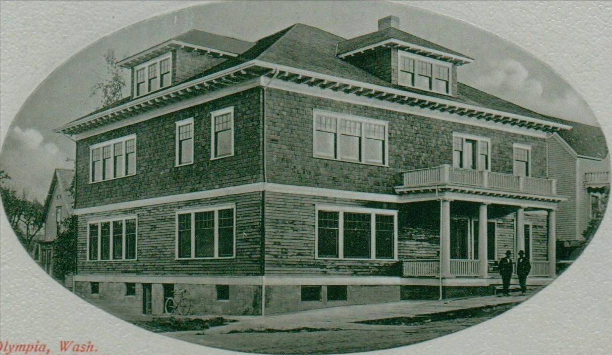
In 1907, the Mowells purchased the
land that the old Central School building was on at 200 Union Avenue in Olympia when the district put it up for auction.27 The school building was moved across the street to 317 Union and now serves as apartments. On the original school lot, the Mowells built a large house, which still stands. Built in the classic Foursquare style, it was considered one of the finest homes in Olympia. The house was quite large. Downstairs was a library, living room, dining room and kitchen all off a central hall. Upstairs were four bedrooms and a bathroom. The house was “modern” in every sense of the
term, with hot and cold running water, indoor plumbing, and electric lighting none of which Ada had growing up as a child. The house cost about $5,000 to $6,000 to construct and was designed by architect Howard E. Gray and built by contractor Harry Shepherd.28
After her marriage, Ada needed little encouragement to be just as or more active in community life as her husband. She had a determined character. Ada was described by lifelong colleague Goldie Robertson Funk as “full of a conquering laughter you know, the kind that hurdles obstacles, reduces difficulties, and makes everybody feel better. But more than this: she came of a blood stream charged with the desire and the will to know and to do; she was eager to get from Life all it could be made to give.”29
Ada had many different interests. She enjoyed outdoor sports, cards, dancing, and automobile driving, and was active in several social clubs. Furthermore, she was interested in the geologic history of the Puget Sound region and with her husband John was an amateur astronomer. But her biggest involvement centered on clubs. Over her long lifetime, Ada was a member of the St. John’s Episcopal Church, Ladies’ Relief Society, Woman’s Club of Olympia, Civic Improvement Club, Eenati Club, History Club, Thurston County Educational Club, Tacoma Country Club, and the Tuberculosis League.30 In addition, she helped organize the
Daughters of the Pioneers of Washington and was a charter member of their Tumwater chapter.31 She even served as the Tumwater Chapter’s second President, from 1931 to 1932.32 She also held the position of State Corresponding Secretary of the Daughters of the Pioneers in 1937.33
Through her extensive club memberships, Ada became involved in many contemporary issues. A Progressive Republican, she supported social reforms such as women’s suffrage.34 While her husband lobbied for Industrial Insurance for workers, Ada worked to ban child labor. For example, at the June 1903 annual Washington State Federation of Woman’s Clubs conference in Everett, Mowell presented a paper titled “Child Labor.”35
The biggest impact Ada made was through the Woman’s Club of Olympia, where she held a membership for 54 years. Becoming a member in 1898, she immediately took an active role. She was quickly appointed as Corresponding Secretary in 1898 and served in that capacity until her first term as president. Ada eventually served as Recording Secretary (1905-1906), Trustee (19071910), again as Corresponding Secretary (1918-1919), Custodian (1927-1928), and Parliamentarian (1933-1934). Additionally, she served as chair of many Departments, including Arts and Crafts (1920-1924), Travel (1924-1925), and International Relations (1932-1933). Ada also chaired their General Committee when
the club affiliated with the Washington State Federation of Women’s Clubs for the first time and represented them as first vice president. She also led state committees on Education, Loan Fund, and as state “chairman of the State Chairmen.”36 Most significantly, she was president of the Olympia group for eight terms: 1901-1903, 19091911, and 1914-1918.
Ada also chaired the committee that organized the construction of the current Woman’s Club of Olympia building, the Abbie H. H. Stuart House at 1002 Washington St. SE in Olympia.37 The building, now on the National Register of Historic Places,
was completed in 1908 and is close to Mowell’s house, just around the corner and down the street. Ada would have easily walked the distance. According to Dr. T. R. Ingham, when John was called out while she was at the Woman’s Club, he would leave a note taped to the door that read: “Ada, the key is under the mat.”38 Home burglaries were less common in those days, but that still was not the wisest idea even then. Also, Ada did all her work despite suffering several lifethreatening illnesses over the years.39
Ada was also involved in the formation of the original Olympia public library. She chaired the Club Library
Committee which started and secured the Carnegie library for the city; the library was dedicated in 1914. She was among club volunteers who served as librarians until the city hired a professional librarian.40
During World War I, Ada was immediately involved with homefront service organizations. Later, Ada served as the Chairman of the Woman’s Work Committee of the Thurston County Council of Defense, making her both the sole woman on the Council and the head of the county’s “Minute Women” volunteers. In this role she helped implement government homefront programs during the war. This included promoting voluntary rationing (which was nicknamed “food conservation”), selling Liberty bonds, and raising money and memberships for the Red Cross.41 During this time she took an active role in public speaking about the campaigns. For example, Ada gave an address at a banquet to open the Second Liberty Loan campaign at which Governor Ernest Lister also spoke. She urged people to encourage family and neighbors to support the war effort through buying bonds and joining the Red Cross.42
After the war ended in 1918, Ada was a leader in the Minute Women Association of Thurston County, part of the Washington State Association of Minute Women which ran for decades promoting patriotic causes. She was made honorary Thurston County councilor for life, and remained involved in its activities,43 including
holding silver teas in the early 1920s to help raise funds for a Minute Woman Association of Washington sponsored marker at the World War I battlefield of Chateau-Thierry in France that honored Washington soldiers who had died there.44 The marker was finally created and dedicated in 1924.45
During World War II, the Minute Women were revitalized, but played a very small role in comparison to other organizations and to their position in World War I. However, the Minute Women of Thurston County did assist on the World War II homefront, regularly acting as hostesses at the Olympia USO Club.46 In 1941, they also started a “cookie jar” project for soldiers, enlisting the aid of local woman’s clubs and published sugarconserving recipes in The Daily Olympian newspaper.47 The group faded out in the early 1950s as its members aged and its restrictive membership rules and redundant roles failed to attract new members.48 Ada later remembered the war as a turning point in community life. Decades after the war Mowell reflected in a short autobiographical sketch that “[i]nto the midst of our busy life came World War I and overnight everything changed. Olympia went all out for war work, Red Cross work, Minute Women, Council of Defense, etc. When it was over life had changed and never quite resumed its old tenor.”49
Ada died on January 6, 1953, but her legacy continues. Perhaps a good way
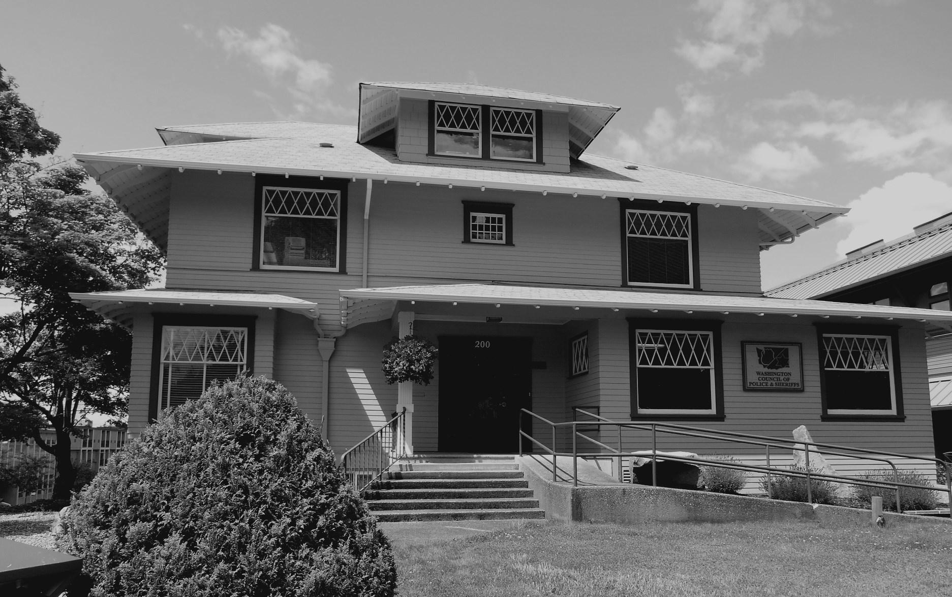
of thinking about her impact is to use her Olympia home as a metaphor. The 1907 Mowell house on Union Avenue was considered one of the best homes in Olympia.50 Over time, the building has gone through extensive renovations, but it survives and now serves as the headquarters for the Washington Council of Police and Sheriffs. Like the house, Thurston County has changed very much since Ada’s time yet her legacy survives through the continuing contributions of the groups she shaped and supported such as the Woman’s Club of Olympia and the Daughters of the Pioneers. Ada’s philosophy can be best summed up by her simple statement that “I couldn’t belong to any group and not do my share.”51 She certainly did her “share” in a way that greatly benefited Thurston County.
1846-1895. Tumwater, WA: Henderson House Museum, 1995, page 14.
4 Blankenship, Early History, page 310.
5 Blankenship, Early History, page 310.
6 Blankenship, Early History, page 310.
7 Blankenship, Early History, page 311.
8 Blankenship, Early History, page 311.
9 Blankenship, Early History, pages 312-313.
10 Blankenship, Early History, page 313.
1 Georgiana Mitchell Blankenship, Early History of Thurston County, Washington: Together With Biographies and Reminiscences of Those Identified with Pioneer Days. Olympia, WA: 1914, page 310. This book spells Ada’s mother’s name as Whilmina. Other sources spell her name as Wilhelmina, Willamina or Wilmina. Wilhelmina is the correct German spelling.
2 Blankenship, Early History, page 309.
3 Jill Kangas and Lanny Weaver, Tumwater Historic District History and Development Water Driven Industry:
11 Blankenship, Early History, pages 311-312.
12 Ada Mowell, “Olympia in My Lifetime,” page 2. Undated manuscript at the Washington State Library.
13 Blankenship, Early History, page 312.
14 Delta Kappa Gamma; Mowell, Ada Sprague in Delta Kappa Gamma Salutes Alpha Sigma State’s Centennial Salute to Washington’s Pioneer Teachers. December 1953. Seattle, WA?: Delta Kappa Gamma, 1953.
15 Mowell, “Olympia,” page 2.
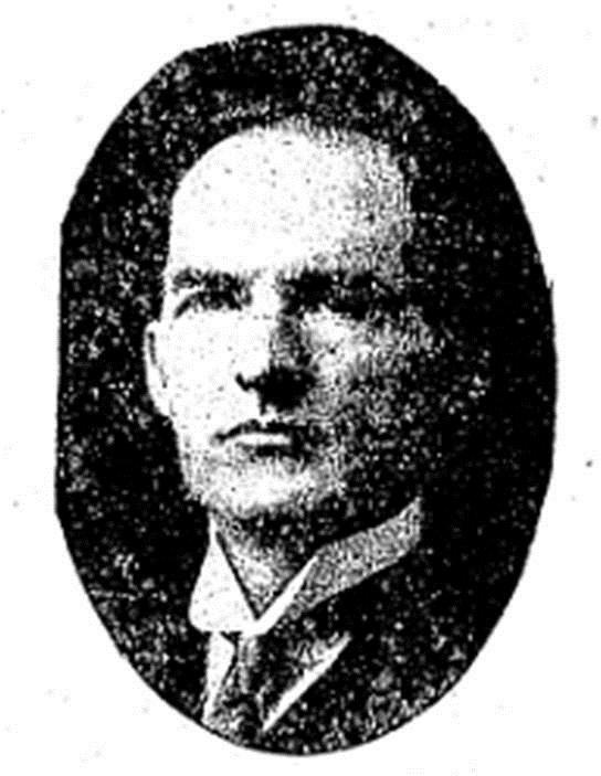
Ada Mowell, seen in a November 23, 1916 Morning Olympian newspaper article, was active in woman’s clubs and civic affairs for half a century.
17 “Kreider Party Returns.” Morning Olympian, August 3, 1897, page 1.
18 Mowell, “Olympia,” page 2. Laura Avery married Ada’s brother Roderick Sprague in 1900. “Mrs. Laura Sprague Succumbs in Seattle.” Daily Olympian, August 21, 1934, page 3.
19 “Kreider Party.”
20 T. R. Ingham, M.D., “John Wilson Mowell 1861-1925,” in “Some of the Early Doctors of Olympia.” Olympia, WA: Thurston County Historic Commission, 1994. Shelley Mowell first served as a bookkeeper at the bank. “Deaths-Funerals: Shelley E. Mowell.” Daily Olympian, December 22, 1965, page 14.
21 “Dr. J. W. Mowell.” Morning Olympian, March 15, 1893, page 3.
22 No title. Morning Olympian, November 19, 1893, page 4.
23 “Dr. John Mowell Dies at Home in Olympia.” Morning Olympian, July 8, 1925, pages 1 and 6.
24 “Commissioners Minutes.” Morning Olympian, May 21, 1896, page 4.
25 “Dr. John Mowell Dies at Home in Olympia.”
26 Mowell, “Olympia,” page 2. They initially paid $8.00 a month for the property, which rose to $20 before they moved out in 1907.
27 Mowell, “Olympia,” page 2.
28 “Dr. Mowell Erects Handsome New Home.” Olympia Daily Recorder, May 11, 1907, page 3.
29 Goldie Robertson Funk, “Celebrating the Birthday of Ada Sprague Mowell November 25, 1941,” page 1. Unpublished manuscript. Washington State Library.
30 “Mowell, Ada Sprague,” in John William Leonard ed., Woman's Who's Who of America: A Biographical Dictionary of Contemporary Women of the United States and Canada, 19141915 . New York: American Commonwealth Company, 1914, pages 582-583.
31 “Deaths & Burials: Mrs. Ada Sprague Mowell.” Daily Olympian, January 7, 1953, page 14.
32 “In Woman’s Realm: Mrs. [F. H.] Gloyd is President.” Daily Olympian, March 20, 1932, page 3.
33 “Society: Pioneer Daughters Honor State Officers.” Daily Olympian, June 25, 1937, page 3.
34 Leonard, Woman’s Who’s Who, page 583.
35 “Will Elect Officers.” Morning Olympian, June 20, 1903, page 3.
36 Funk, “Celebrating,” page 3.
37 Funk, “Celebrating,” page 3.
38 Ingham, “John Mowell,” in Early Doctors. Dr. T. R. Ingham’s father Dr. George Ingham had been a friend of Dr. Mowell. Such great friends, that T. R. called him, “next to my father . . . the greatest doctor.” Dr. Mowell helped deliver T. R. at birth.
39 Funk, “Celebrating,” page 2. Funk does not state what these illnesses were.
40 Funk, “Celebrating,” page 3.
41 Jennifer Crooks, “Patriotism and Paranoia: The Thurston County Minute Women of World War I.” COLUMBIA, 31 No. 3, Fall 2017: pages 22-26, 23.
42 “Loan Drive Gets Enthusiastic Sendoff.” Morning Olympian, October 2, 1917, page 1.
43 “Organization of County Minute Women Formed.” Morning Olympian, March 11, 1920, page 1.
44 “Social and Personal.” Olympia Daily Recorder, May 8, 1922, page 3. “Society.” Olympia Daily Recorder, October 7, 1922, page 3.
45 Shanna Stevenson, “Minute Women of Washington,” Washington State Historical Society, Women’s History Consortium, http://www. washingtonhistory.org/research/whc/ milestones/aftersuffrage/ minutewomen/ (accessed August 11, 2013).
46 For example: “USO Hostess Calendar.” The Daily Olympian, November 4, 1942, page 12; “USO Hostess Calendar.” The Daily Olympian, September 1, 1943, page 8; “USO Hostess Calendar.” The Daily Olympian, April 2, 1945, page 3.
47 “Cookie Jar Arranged For New USO Building.” The Sunday Olympian, February 15, 1942, page 1.
48 Jennifer Crooks. “Patriotism & Paranoia.” Pages 22-26, 26.
49 Mowell, “Olympia,” pages 6-7.
50 “Dr. Mowell Erects Handsome New Home.” Page 3.
51 Funk, “Celebrating,” page 2.
Jennifer Crooks grew up in Olympia. She recently graduated from Central Washington University with a Master of Arts in history, and is especially interested in early 20th Century American social history.
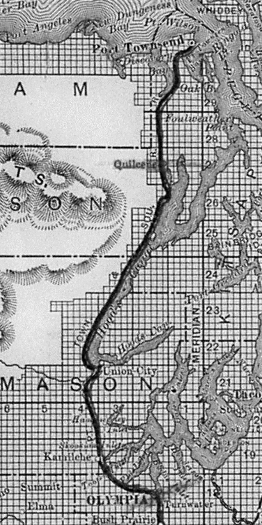
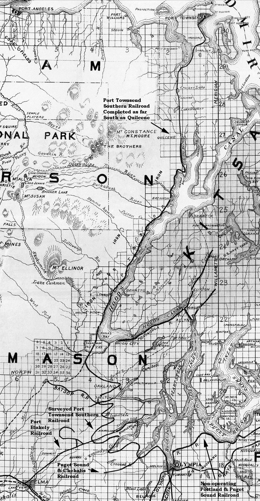
Many residents of Thurston County are aware that a narrow gauge railway (the Olympia & Chehalis Valley Railroad) ran between Olympia and Tenino in the 1880s. That line was widened to standard gauge in 1891, when it was merged into the Port Townsend Southern Railroad.1 Less well-known are the schemes developed by the Oregon Improvement Company (a holding company which controlled the Port Townsend Southern) to build a rail link between Port Townsend and Olympia. Those endeavors are the subject of this article.
The Olympia & Tenino Railroad began operating in 1878. It underwent reorganization in August 1881, with a change in name to the Olympia & Chehalis Valley Railroad. In 1884 and again in 1886, it was rumored
Figure 1: Map of Western Washington Showing the Railroads of the Oregon Improvement Company. Copyrighted, 1890, by E. H. Morrison, General Land Agent Oregon Improvement Company. University of Washington Libraries, Special Collections Division, Allen South, Accession No. 0249-001, Oregon Improvement Company Records,Box81.
that the line would be lengthened into the coal fields south and east of Tenino. However, such expansion did not take place.
The Port Townsend Southern Railroad was incorporated in 1887 by fanciful Port Townsend business people who wanted to make Port Townsend the terminal for a transcontinental railroad. But financing a huge, ongoing project like that was more than the Port Townsend community could sustain. By 1889, the railroad still had not laid any track, and the enterprise was sold to the Oregon Improvement Company. Late that year, the Olympia & Chehalis Valley Railroad also came under control of that same Oregon holding company.
Detailed location survey maps for much of the Port Townsend Southern Railroad have not been located. However, a Mason County deed suggests that mid-1889, the right-of-way was intended to pass through Union City (now called Union) on Hood Canal, in Mason County.2 Figure 1, from a map produced in 1890, provides a general idea of the right-of-way proposed between Port Townsend and Olympia. The pathway shown appears to be a schematic generalization; clearly, it is grossly inaccurate (as will be demonstrated later) between Union City and Olympia. The pre-existing Olympia & Chehalis Valley Railroad, leading from Olympia to the south, is also visible in this figure.
The valuation record of the Port Townsend Southern Railroad Company in-
dicates that on July 1, 1889, a contract was made with Elijah Smith of New York City (the President of the Oregon Improvement Company) to build the line between Port Townsend and Olympia. During 1890 and 1891, 27.304 miles of railway were constructed from Port Townsend south to Quilcene.3 However, that right-of-way was never extended farther than Quilcene.
Also in 1890, work began in Olympia on a right-of-way toward the north, along the west side of Budd Inlet. The June 20, 1890 Washington Standard reported: “The San Francisco Bridge Company has received the contract for building the Port Townsend Southern track from the present terminus of the narrow-gauge to Butler’s Cove. A large portion of the road-bed will be on piles. Work will begin in a few days.” The Washington Standard mentioned on July 18, 1890: “Piles for the Port Townsend Southern Railroad track are being driven along the water front of Westside. They will be used for a mile or more when the route passes to the land and will be built on the beach with cribbing and fill. The road bed will be fifteen feet wide.”
Later that year, a delay was anticipated in completing the track between Quilcene and Olympia. The October 10, 1890 Railroad Gazette reported: “Port Townsend Southern – About four miles have been graded north from Olympia in the direction of Union City, Wash., at the end of Hood’s Canal. The company will connect by boat with Quilcene. . . . Between Union


City and Tenino a few right of way cases have not yet been adjusted.”
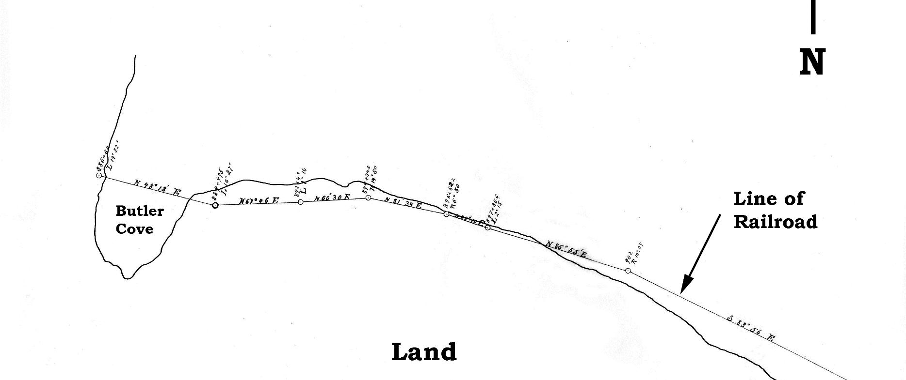
Figure 2 is part of an 1890 map which reveals the company’s initial conception of where the railroad would be located, north of Olympia. As mentioned above, it was to run on pilings, or use cribbing along the shoreline, most of the way to Butler Cove. Figure 3 is part of the survey (near Butler Cove) for this right-of-way, which was submitted April 22, 1890. Readers who are familiar with the topography around Butler Cove will understand why this route was subsequently rejected. The grade is too steep; over a relatively short distance, it rises from water level to a much higher elevation on the west side of Butler Cove (where the Olympia Country Club is situated currently). As early as August 16, 1890, the Port Townsend Southern Railroad began securing an upland right-of-way for its extension north of Olympia.4
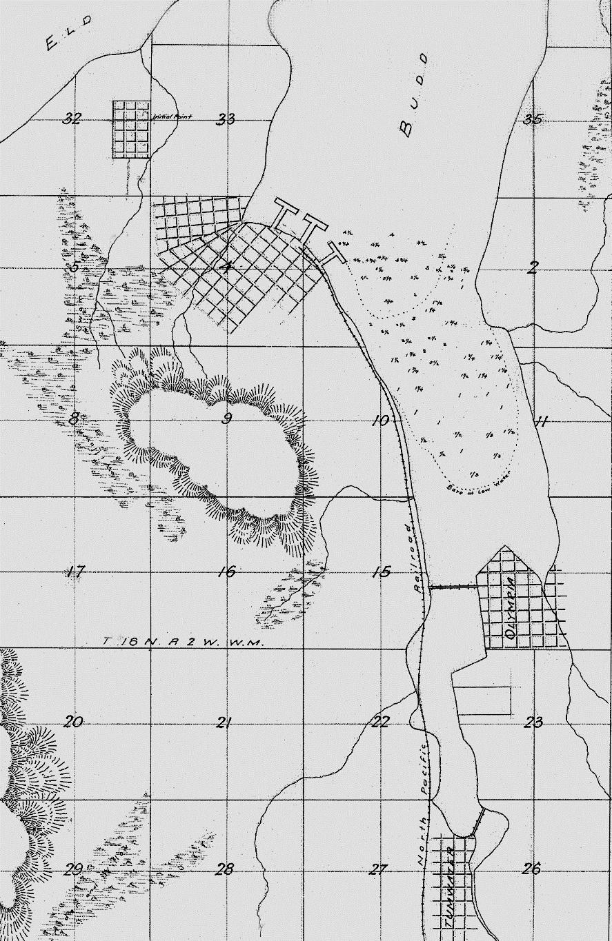
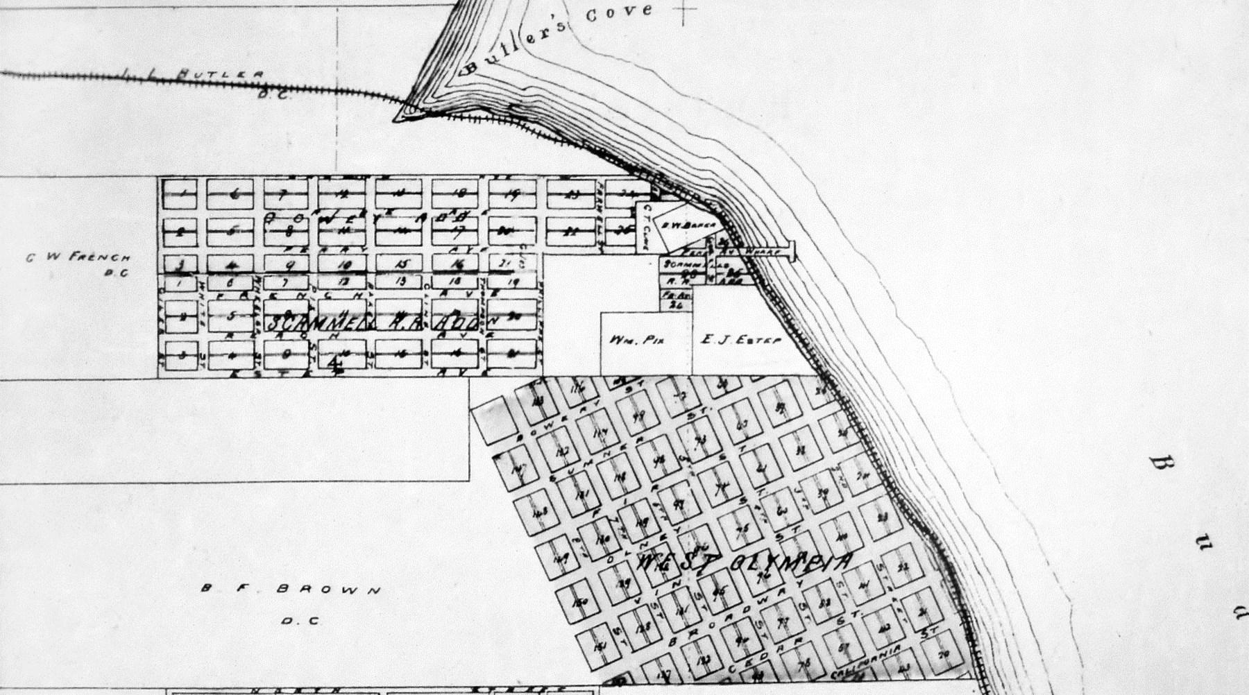
This raises a question about why the railroad wanted to go to Butler Cove in the first place. The answer is, to export coal. Although a long wharf had been constructed in downtown Olympia in 1888, dredging of the harbor had not been completed. Docking ocean-going ships downtown remained a challenge. In the early 1870s, when the Northern Pacific Railroad flirted with the idea of making Olympia its Puget Sound terminal, one group of local business people suggested creating an extensive docking facility at Butler Cove. Coal from
the south part of Thurston County was to have been one of the commodities handled there. Figure 4 is the plat of their unfulfilled proposal.
Renewed interest in exporting coal was demonstrated in 1889 when the Olympia & Chehalis Valley Railroad purchased a right-of-way immediately northeast of Centralia, in Lewis Coun-
ty.5 An extension of the railroad over that property was never constructed. However, later, the Eastern Railway & Lumber Company did build its own line in that general area.
The situation regarding exportation of coal was clarified in 1890 by an article in the April 25 issue of Railroad Gazette:6 “Olympia & Chehalis Valley. - It is stated that the Oregon Improvement Co. has purchased this road, and will extend it south six miles to Cherry Hill, Wash., and to other points, and also change the gauge to standard. The road extends from Olympia to Tenino, 15 1/2 miles, and is of 3-ft. gauge.” The significance of “Cherry Hill” will be clarified later in this article.
The October 31, 1890 Railroad Gazette reported a situation that presaged serious problems in construction at the Olympia end of the line toward Union City: “Port Townsend & Southern –This line has been completed (except for track-laying) as far as Mud Bay, and the work at Olympia, Wash., will be discontinued.” The laborers who had been toiling there were sent by boat to Quilcene, to continue the task of clearing and grading.
In the spring of 1891, when construction at the Olympia end of the line to Union City should have resumed, the railroad’s parent company (the Oregon Improvement Company) was experiencing a cash flow problem. Coal miners at its Franklin mine (located in eastern King County) had gone on strike the previous fall, and were being
joined by miners at Newcastle and Black Diamond. A vicious labor dispute resulted, and for many months, the Oregon Improvement Company was unable to fulfill contracts for coal from its own mines. It had to purchase almost $500,000 worth of coal in San Francisco and British Columbia to meet those commitments. In addition, costs relating to the strike itself amounted to $75-80,000, money which had been earmarked for construction.
The company’s monetary crisis may have contributed to the fact that, early in 1891, the San Francisco Bridge Company was no longer working on the extension north of Olympia. On March 1, 1891, J. H. Smith & Company received a contract to complete the three-mile extension to Butler Cove.7 Work resumed. The April 24, 1891 Washington Standard declared: “Bids for grading the Port Townsend Southern between Olympia and Union City will be opened May 10th.” Shortly thereafter, a major change took place in the projected grade alignment between Quilcene and Olympia. No longer would the track pass through Union City. William Harlan Kennedy, a highly respected railroad engineer who specialized in locating new grades, had been hired to oversee adjustments to the right-of-way. He worked with Colonel Simon W. Scott, who later became the General Land and Tax Agent for the Oregon Improvement Company.
An article in the May 15, 1891 Mason County Journal pertained to right-of-
way relocation and apparently was taken from two separate sources. The first came from a news report out of Tacoma; the second seems to have originated at The Olympian: “The Port Townsend Southern – Tacoma – May 9. – There is a welldefined rumor here that the Port Townsend Southern has been purchased by the Union Pacific. Engineer Kennedy, who was assistant chief engineer of the Union Pacific, under Engineer Bogue, is now in Olympia looking over the work of the road with Colonel Scott, the right of way agent of the road. Mr. Kennedy has been employed by the latter company (the Port Townsend Southern Railroad) to relocate its line from Olympia to Union City, and will begin operation on Monday.
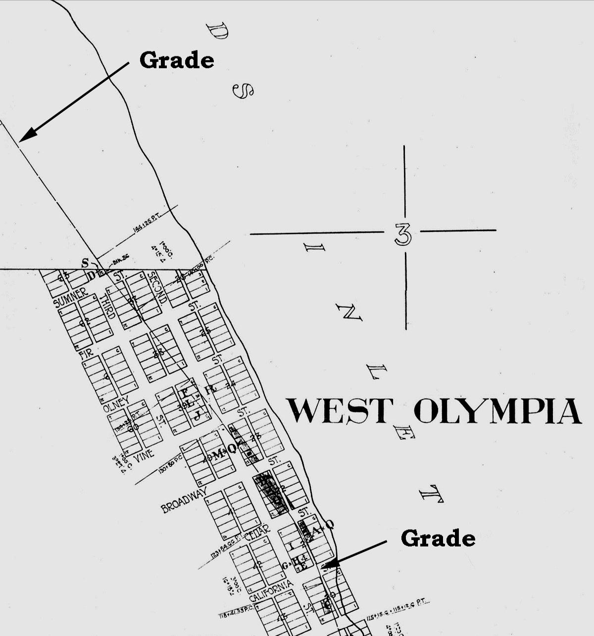
Figure 5: Northern Pacific RailroadRight-of-WayPlatMap,ThurstonCounty Assessor’s Office. The subdivision of West Olympia was recorded October 16, 1869. Thurston County Auditor’s Plat # 2700005.
“Engineer Kennedy, late assistant chief engineer of the Union Pacific line, is in the city with Colonel Scott, the right of way agent of the Port Townsend Southern [unknown why this redundancy was included].
Mr. Kennedy has been employed by the latter company to relocate its line from Olympia to Union City, and will begin operation this morning. Whether or not the employment of Mr. Kennedy on this work has any significance in
connection with the rumor of the purchase of the Port Townsend Southern people, The Olympian is not advised.” But the Union Pacific Railroad did not buy the Port Townsend Southern, for it was struggling to construct its own line through Olympia, the Portland & Puget Sound Railroad.
Figure 5 shows the path chosen for the extension north of Olympia, as it
passed through West Olympia. Figure 6 is part of a map made in 1891. Likely, it is a good representation of the intended route of the Port Townsend Southern Railroad between Quilcene and Olympia, after the right-of-way was adjusted by Engineer Kennedy. Note that Union City was to be bypassed. By September of that year, all the finished right-of-way (Port Townsend to Quilcene and Tenino to Butler Cove) was ready for operation as a standard-gauge railroad. Records preserved at the University of Washington Libraries, in Seattle, indicate that during that month, the railroad’s Chief Engineer accepted into service the Port Townsend Division, from Port Townsend to Quilcene, 27.6 miles, and the Olympia Division, from Tenino to Butler Cove, 18.0 miles.8 In the same box of records, another (undated) document gave the operational distance between Tenino and Butler Cove as 17.6 miles.
What was the actual configuration of the right-of-way built between Olympia and Butler Cove? Figure 7, prepared in February 1891, confirms that a pathway primarily on shore had already been substituted for the pathway visualized in Figure
2. Evidently, the route immediately north of Brown’s Wharf was not yet settled, even though some grading in that region may have been done the previous year (as reported above in the October 31, 1890 Railway Gazette). Brown’s Wharf had been Olympia’s only deep-water moorage
Map
and
Country. Compiled from the Latest Official Data and Other Sources. By C. H. Amerine. Published by the Lowman & Hanford Stationery & Printing Co., Seattle, Wash. 1891. Courtesy of David Rumsey Map Collection.
until approximately 1888, when downtown Olympia’s Main Street Wharf was opened.
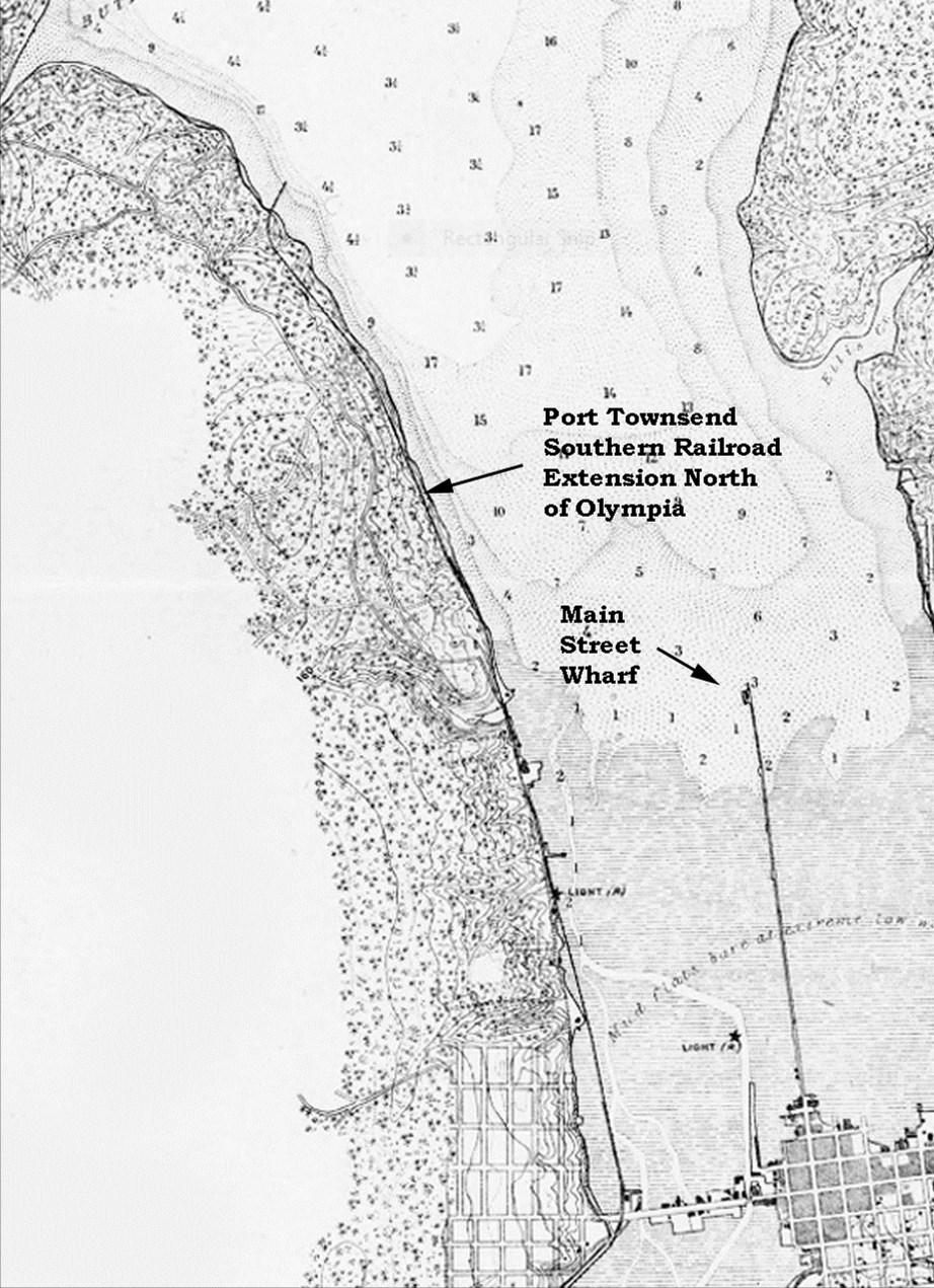
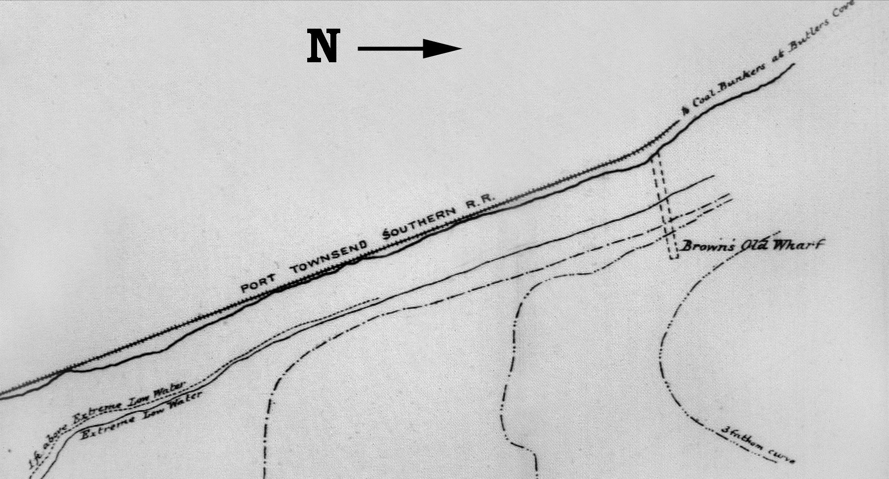
rent Old Port community is located, commercial activity at Brown’s Wharf must have been significantly reduced after 1888.
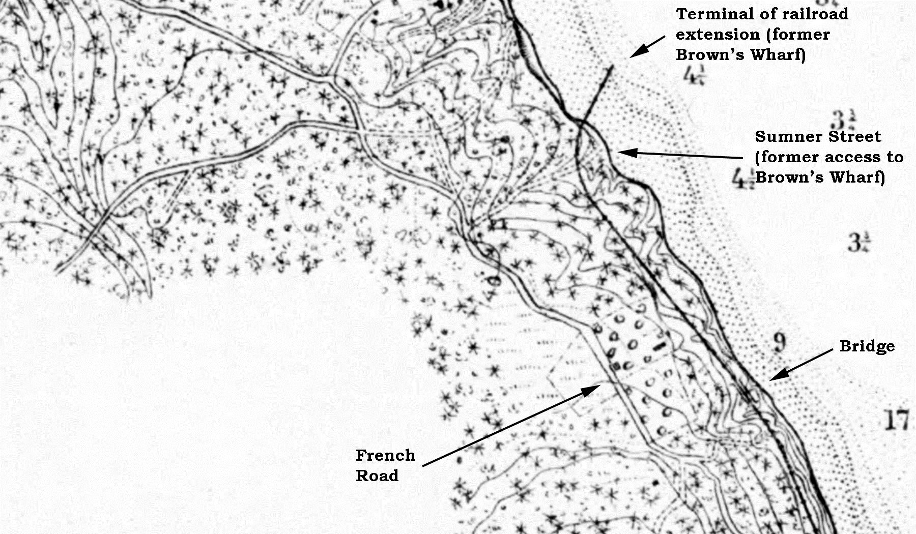
Figure 8 was published in June 1892. Its topographical data was first gathered in 1876 and was updated with survey data gathered during July and August 1891, by J. J. Gilbert of the U. S. Coast and Geodetic Survey. Figure 9 comes from the same map. It enlarges the area at the northern terminal of the Port Townsend Southern Railroad extension. In this map, the right-ofway ends at a wharf on Budd Inlet, which corresponds precisely with the location of the pre-existing Brown’s Wharf.
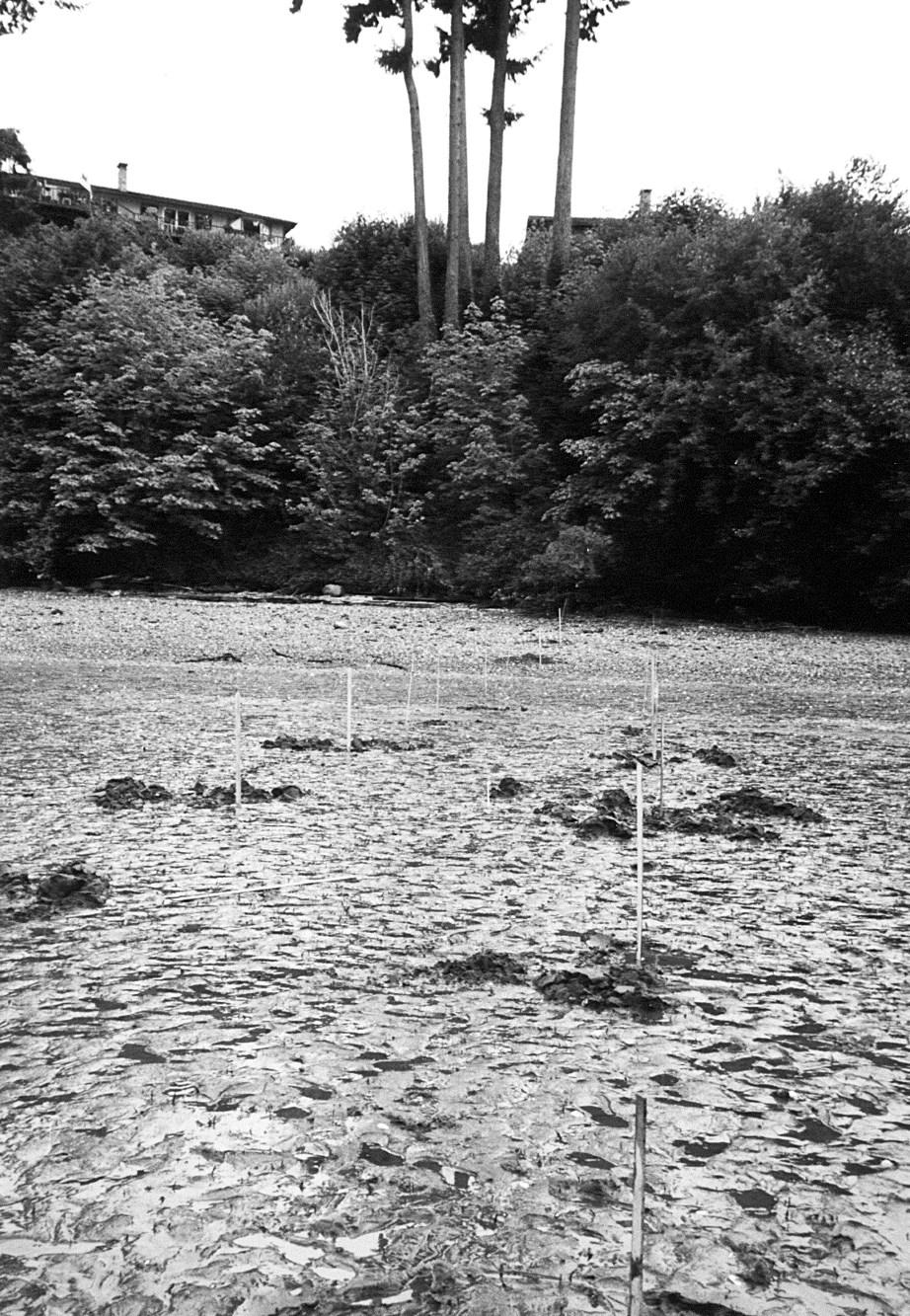
There is no record of passenger trains running on the extension; the right-ofway appears to have been operated as a spur line, without regularly scheduled freight service. Traffic over the extension must have been limited to exportation of coal by the Cherry Hill Coal Company. That organization was incorporated at Olympia December 27, 1889 by Edmund Rice, Stuart Rice, George D. Shannon, and John F. Gowey. The company recorded approximately fifteen deeds for the purchase of coal-bearing properties in Thurston County between September 1890 and July 1893. These included most of the Snyder & Stevens Plat of Tenino and parcels southeast of Tenino. Surface outcroppings of coal were common around Tenino; an earlier name for that community was “Coal Bank.” Of equal significance, the coal company acquired a portion of the
George W. French Donation Claim (part of Section 3, Township 18 North, Range 2 West). That parcel is precisely where Brown’s Wharf was located.9
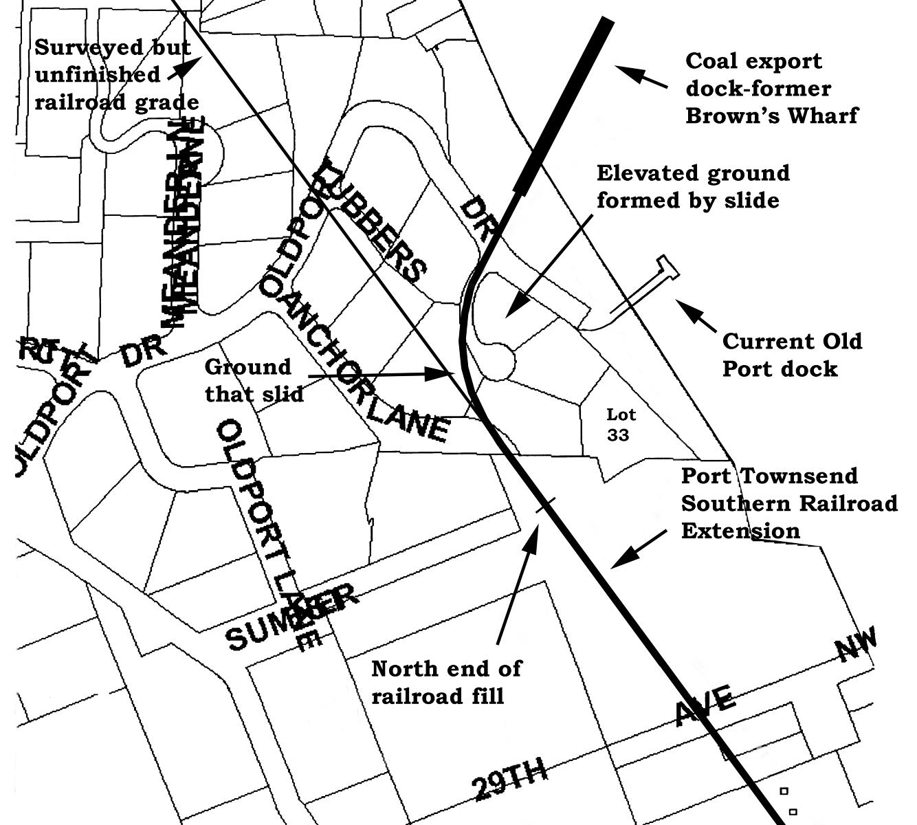
When visiting the Old Port community today, it is difficult to imagine how the northern end of the extension could have descended to the level of the wharf. A sketch of Old Port, by Janice Hilliard, exemplifies this difficulty. In this document, the railroad grade descends on an impossibly steep grade.10
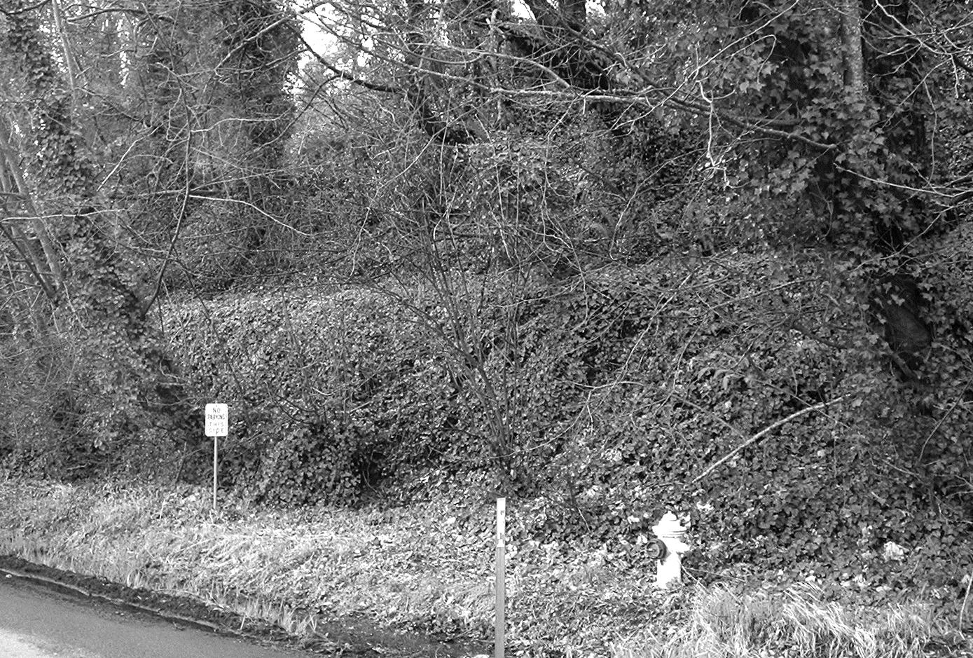
Immediately south of Old Port, the railroad grade is visible as a significantly high fill, immediately south of Anchor Lane. From that point, Anchor Lane rises so steeply that it could not have been used (as it appears today) to gain access to Brown’s Wharf.
Fred Saeger was living in this area before the Old Port community was developed. He recalls that a slide occurred there sometime before his family moved to the neighborhood. Figure 10 is a map of Old Port which shows where the slide started, and where it came to rest. Clearly, it obliterated much of the grade to the wharf. Whatever was left was probably filled in to create the south end of Anchor Lane when Old Port was developed. Anchor Lane became the necessary access road for Lot 33.
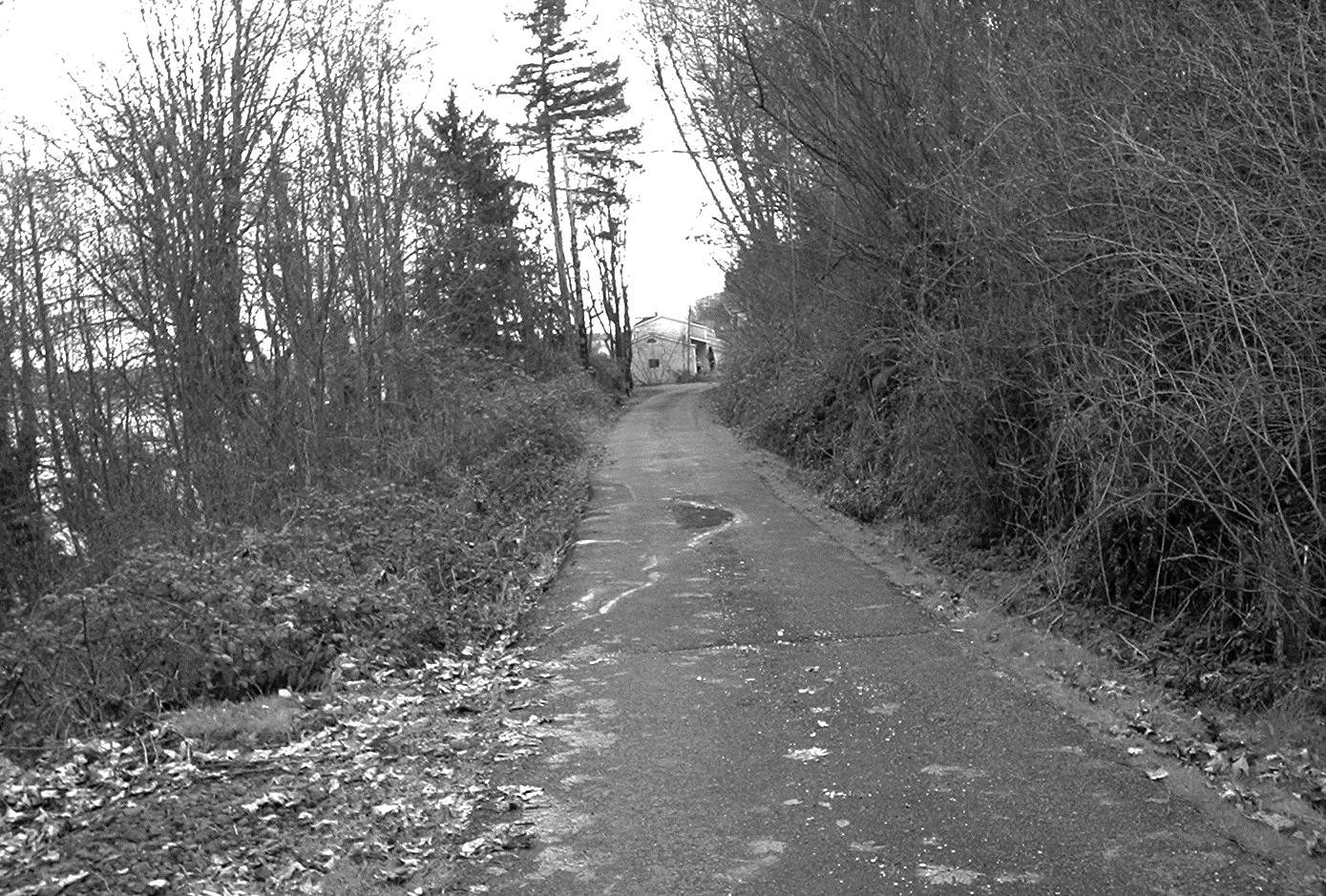
Figures 11 through 15 are early 21st Century photographs of other parts of the extension. The track to Butler Cove was abandoned in 1894.3 This was probably caused, indirectly, by the financial panic of 1893. The busi-
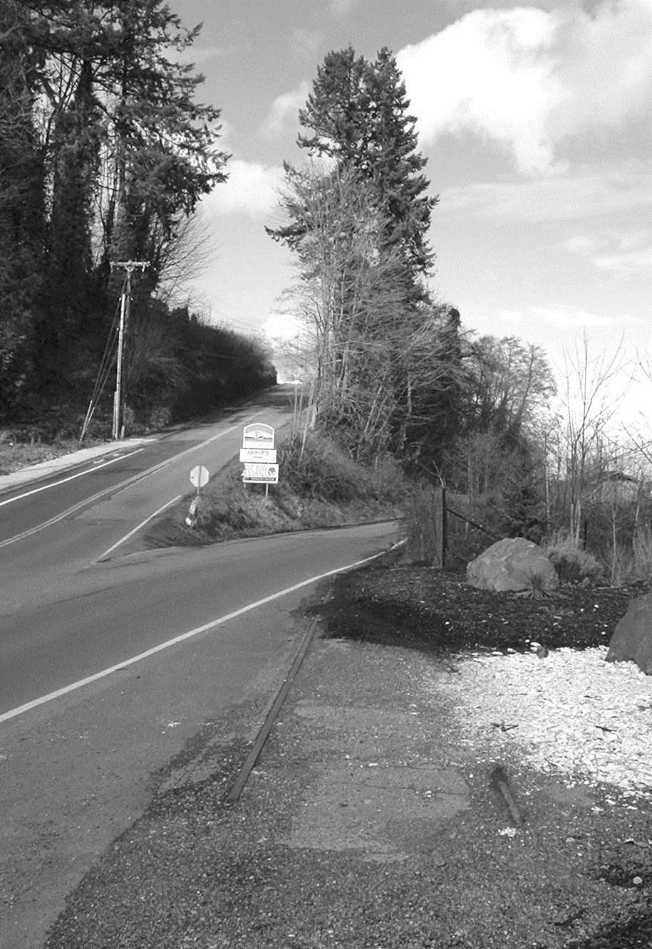
West Bay Drive, showing the bench upon which the railroad lay as it gained elevation. The photo was made approximately 500 feet north of Figure 11.
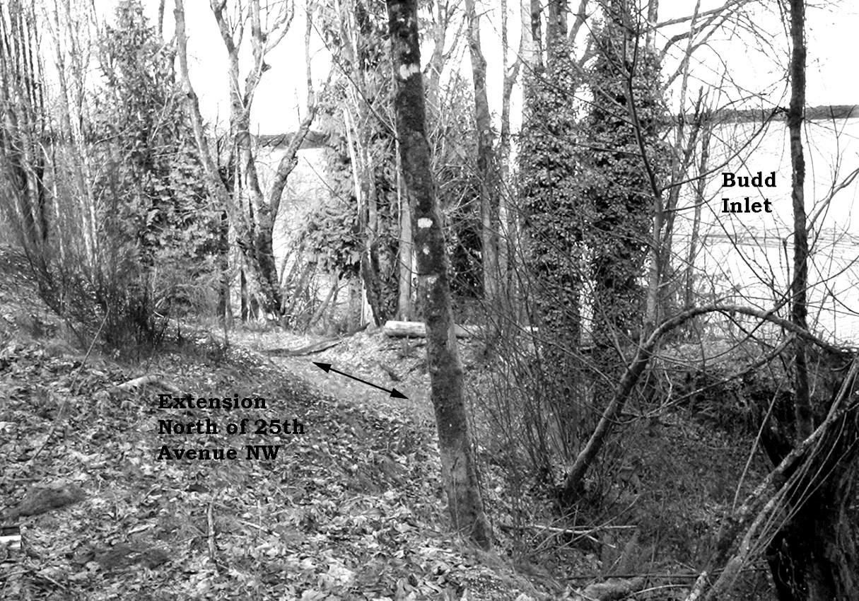
along the extension where it follows 25th Avenue NW. 25th Avenue NW originates at Crestline Drive NW, travels northeast, and turns 90 degrees to pass southeast, paralleling the shore of Budd Inlet.
Figure
northeast from a point just west of the place where 25th Avenue NW makes its 90degree turn. To the immediate north, the railroad crossed a canyon with a bridge visible in Figure 9.
ness of the Cherry Hill Coal Company must have failed that year, for it was in default on a $50,000 mortgage taken on coal-bearing land in south Thurston County.11 When coal traffic on the extension evaporated, the rails were picked up.
Figure 16 is an enlargement of Figure 6 showing the region immediately west of Olympia. The October 31, 1890 article in Railroad Gazette, quoted above, suggests that some clearing and grading was done to the west of Butler Cove. A certain Thurston County deed
probably identifies where part of that right-of-way was located.12 Therein, the Cherry Hill Coal Company bought a parcel to the west of the modern-day Evergreen State College campus. This is compatible with the surveyed route having run immediately north of the main campus buildings, and the coal company anticipating use of the railroad for exporting its product.
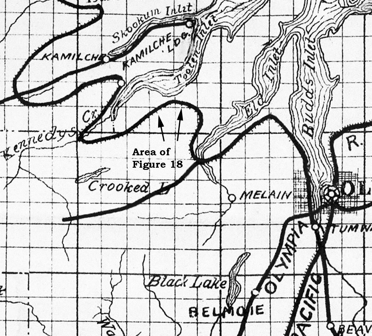
Arrows visible in Figure 16 indicate a region farther west (in the south part of the Steamboat Island Peninsula) where topographic features suggest that grading took place. Figure 17 indicates two places where surface alterations are consistent with human activity; these line up precisely with the grade of the Port Townsend Southern Railroad, as seen on Figure 16.
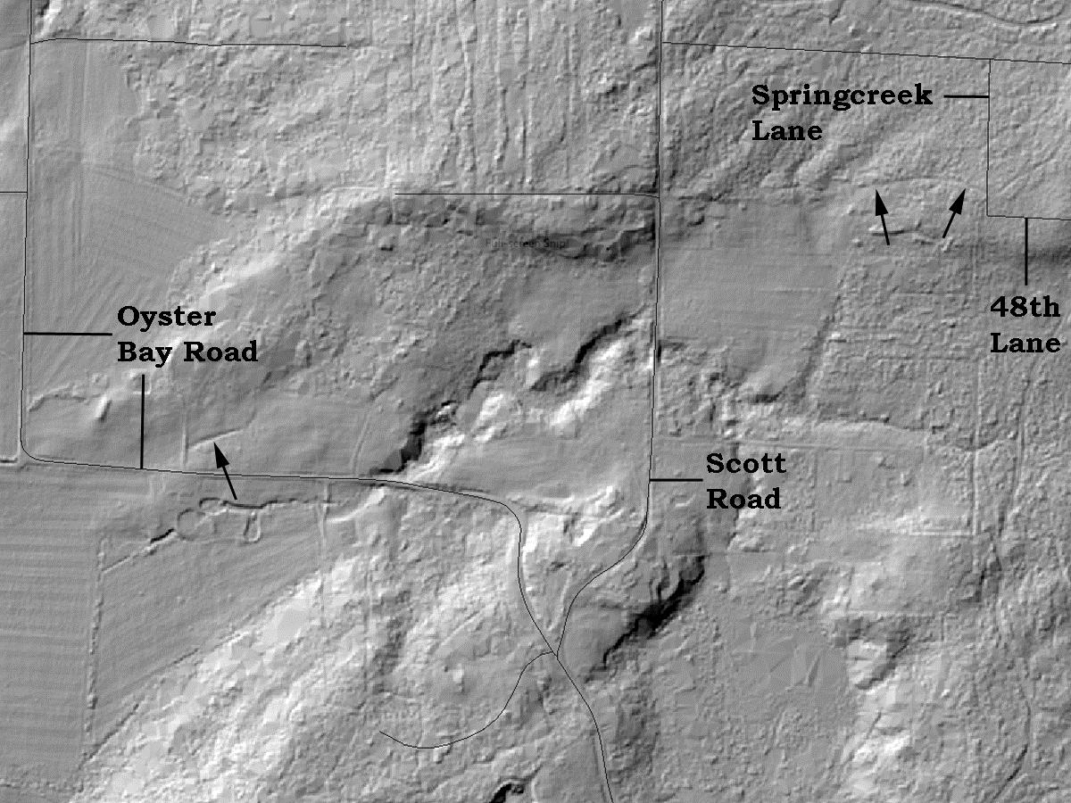
Figure 18 is a map published in 1903. It shows the proposed location for the permanent campus of the People’s University, situated at a community
on Cooper Point called Athens. The university never moved there from downtown Olympia, closing its doors in 1906. Nonetheless, the surveyed
route of the Port Townsend Southern Railroad, between Olympia and Mason County, is still represented on this map. In the years after 1894, the railroad company never gave up planning to build this line someday. Indeed, it resurveyed the right-of-way in 1906, but did not resume construction. Figure 18 is probably the most accurate conception of this never-completed railroad.
Commission Reports. Docket No. 803 also specifies that “This report also embraces the valuation of the property of the Port Townsend Southern Railroad Company.” Washington State Law Library.
NOTES1 Gauge, in respect to a railroad, is the distance between the two rails which comprise a segment of track. Standard gauge is 56.5 inches; narrow gauge is any distance less than that. The Olympia & Chehalis Valley Railroad used a gauge of 36 inches.
2 In Mason County Deed Book S, pages 267-269, dated June 19, 1889, the Port Townsend Southern Railroad Company buys 500 lots in Union City from the Hoods Canal Land & Improvement Company. The sale was conditional upon the location, by July 1, 1890, of a standard-gauge railroad from the Bay of Port Townsend, via the west side of Hood Canal, to the Columbia River “or with some railroad in Washington Territory in operation, and having transcontinental connections.”
3 Valuation Docket No. 803, Port Townsend and Puget Sound Railway Company et al. Submitted June 26, 1926. Decided September 17, 1926.
Volume 116 I of Interstate Commerce
4 Thurston County Deed Book 23, page 223, Washington State Archives, Southwest Regional Branch. Theodore L. Brown, Martha Brown, and Benjamin F. Brown sold to the Port Townsend Southern Railroad a right-of-way over Lots 1, 2, 3, 7, 8, 9, 10, 11, and 12 of Block 22, in the Plat of West Olympia.
5 Lewis County Deed Book P, page 726, dated April 17, 1889, Washington State Archives, Southwest Regional Branch. Therein, the Olympia & Chehalis Valley Railroad Company bought a strip of land 50 feet wide through the south half of the northeast quarter of Section 3, Township 14 North, Range 2 West.
6 Railroad Gazette, April 25, 1890, page 294.
7 Minnesota Historical Society, Northern Pacific Records, Port Townsend Southern Railroad Company, Box 3, Folder 9. Therein, J. H. Smith & Company was contracted to build the three-mile extension on March 1, 1891. This company was located at the corner of First and Stark Streets, Portland, Oregon.
8 University of Washington Libraries, Special Collections Division, Allen South, Accession No. 0249-001, Ore-
gon Improvement Company Records, Box 78.
9 Thurston County Deed Book 22, page 386, dated October 23, 1890, 10 acres, $9,000.00. Washington State Archives, Southwest Regional Branch.
10 Thurston County Judgment Book 3, page 63, dated November 27, 1893, Washington State Archives, Southwest Regional Branch. A judgment regarding the mortgage issued by the Cherry Hill Coal Company October 1, 1890.
11 Thurston County Deed Book 20, page 741, dated September 8, 1890, Washington State Archives, Southwest Regional Branch. The Cherry Hill Coal Company bought Lots 2, 3, and 4 and the south half of the southeast quarter of Section 1, Township 18 North, Range 3 West. This parcel is approximately 0.6 mile west of The Evergreen State College campus.
12 Unpublished documents circulated locally within the Old Port community: 1. The History of Old Port, by Mrs. Marion T. Lemon, circa 1971. She lived in the Lemon house at Old Port until 1989. She was born in 1899 and was the wife of Millard Gerry Lemon, who was the son of Millard Lemon (born about 1853 in Idaho). 2. Sketch of Old Port by Janice Hilliard, the daughter of Millard Gerry and Marion T. Lemon. She was born circa 1931 and grew up at the place that became Old Port.
Dr. Hannum is a retired physician and surgeon who spent his early years in Michigan. He arrived in western Washington in 1971 as a member of the U.S. Public Health Service. Railroad history has been a life-long interest, and he has written several books on the subject.
Researchers looking for information on the earliest Washington pioneers would do well to search the records of the Provisional Government of Oregon. Pioneers who settled in the Pacific Northwest before 1853 were technically living in Oregon Territory, or its precursor, the Oregon Country. And until Thurston County was created in 1852, our area was part of a much larger Lewis County, created in 1845.
Jointly occupied by the British and Americans, the Oregon Country established a provisional government, with its own legal system, in 1843. In 1846, the Oregon Treaty divided the Oregon Country between Great Britain and the U.S. In 1848, the U.S. Congress created the Oregon Territory; its duly appointed governor, Joseph Lane, arrived at Oregon City in 1849, when a territorial government was created.
Between 1843 and 1849, what was known as the Provisional Government of Oregon maintained records on residents and events in the Oregon Country. This included the present-day states of Oregon, Washington, and Idaho, small portions of Montana and Wyoming, and nearly half of presentday British Columbia, comprising over 285,000 square miles.
Today, copies of these provisional government records are preserved on microfilm at the Washington State Library in Tumwater, and are formally titled “Papers of the provisional and territorial government of Oregon, 1841 -1859.” The records are not available online, but require a site visit to the library.
The records include two sets of microfilm reels. The first is an index to the records. Alphabetized by last name of a resident (such as Sylvester, Edmund), or by subject (such as Olympia, Deschutes River, Thurston County, elections, vessels, and so on), the index leads researchers to a second set of microfilm which contains the records themselves: all 14,211 of them.
As an example, the index card for pioneer David Chambers lists three separate documents that contain his name. The numbers 1082, 1805, and 1854 refer to the actual documents. Switching to the pertinent microfilm reel of records, document #1805 is titled “1849 Election Returns, Lewis County, Newmarket Precinct.” During this election, David Chambers ran for the office of Lewis County judge, and received nine votes. The other documents include an 1849 Lewis County
census (document #1082) and a general election of 1851 (document #1854, where Chambers ran for Lewis County Treasurer, but lost).
These provisional government records are underutilized, but offer a great deal of interesting information on our earliest settlers.
Chambers, David
1082 Census, Lewis county, 1849
1805 Election returns, Lewis county, 1849
1854 Election returns, Lewis county, 1851
Above: The index card for David Chambers and related documents.
Below: The 1849 election return showing David Chambers with nine votes for the office of judge.
Karen L. Johnson has volunteered and worked in the museum field since 2001. Her interests in early transportation and the pioneer era have led to organizing two stagecoach runs between Olympia and Longview, writing many articles on local and regional history, and co-authoring with Dennis Larsen two books about a Washington pioneer.
Situated in the foyer of the General Administration building on the Washington State Capitol Campus, this intricate mosaic is a hidden gem in Thurston County. According to the National Register nomination, the GA building was “the first major building to be constructed on the capitol campus after the Great Depression.” The nomination continues: “Typical of the modern style which called for the integration of art and architecture, [architect A. Gordon] Lumm called for a large mural to be installed in the entrance lobby. However, the building would have to wait until 1959 when Bellevue artist Jean Cory Beall was selected to create a glass-stone mosaic mural.
“Beall received her training at the California College of Arts and Crafts and continued to hone her craft at Parsons Paris School of Design, France; Institute Politecnico in Mexico City; and the Art Students' League in New York City.
“Her commission for the General Administration Building was selected from among eight designs and cost $12,880. The convex mosaic dominates the lobby, measuring 10.5 feet high and 29.5 feet long, and includes iconographic imagery representative of Washington's industrial and natural resources. The design references the state's atomic research center, aeronautics industry, hydroelectric power
production, timber, fisheries, game, minerals, other natural resources, and recreational facilities.
“The pictures are linked together by a great river of rough cut stones flowing across the mural.
“The design was originally created in watercolor by Beall. She took her painting to Venice where she and a Prof. Gaspari supervised the cutting and assembly of over 150,000 pieces of tesserae, or small pieces of glass, a Byzantine-era technique from the 4th6th centuries originally applied in European cathedrals, and some stone pieces. The work was then transported by ship to Olympia, where Beall and mural assembly supervisor, Martin Carlson, installed the piece with a work crew of six.”1
1 Annamary Fitzgerald, National Register nomination, July 1, 2006, https:// fortress.wa.gov/dahp/wisaardp3/api/ api/resultgroup/186701/ doc/1462211166089
To view the mural, visit the General Administration Building located at 210 11th Avenue SW, Olympia (on the northern edge of the capitol campus). The building is open from 8 a.m. to 5 p.m., Monday through Friday, excluding state holidays.
Composed of over 150,000 pieces of tesserae (small pieces of glass), this vibrant work of art can be found in a mid20thCentury building in Thurston County. But do you know where?
Article and photograph submitted by Megan Ockerman, a native Olympian and recent WSU history graduate. She wrote her Master’s thesis on the history of the Olympia Brewing Company and is working on turning that project into a manuscript for publication. She recently served as assistant curator for the Olympia Tumwater Foundation.