Number 3 August 2017
Olympia: In the Eye of the European Beholder
Maritime History of Olympia and South Puget Sound
Mining Coal: An Important Thurston County Industry 100 Years Ago

$5.00


Number 3 August 2017
Olympia: In the Eye of the European Beholder
Maritime History of Olympia and South Puget Sound
Mining Coal: An Important Thurston County Industry 100 Years Ago

$5.00

The Thurston County Historical Journal is dedicated to recording and celebrating the history of Thurston County. The Journal is published by the Olympia Tumwater Foundation as a joint enterprise with the following entities: City of Lacey, City of Olympia, City of Tumwater, Daughters of the American Revolution, Daughters of the Pioneers of Washington/Olympia Chapter, Lacey Historical Society, Old Brewhouse Foundation, Olympia Historical Society and Bigelow House Museum, South Sound Maritime Heritage Association, Thurston County, Tumwater Historical Association, Yelm Prairie Historical Society, and individual donors.
Publisher
Olympia Tumwater Foundation
John Freedman, Executive Director
Katie Hurley, President, Board of Trustees
110 Deschutes Parkway SW P.O. Box 4098
Tumwater, Washington 98501 360-943-2550
Editor
Karen L. Johnson 360-890-2299
Karen@olytumfoundation.org
Editorial Committee
Drew W. Crooks
Janine Gates
James S. Hannum, M.D.
Erin Quinn Valcho
The Journal welcomes factual articles dealing with any aspect of Thurston County history. Please contact the editor before submitting an article to determine its suitability for publication. Articles on previously unexplored topics, new interpretations of well-known topics, and personal recollections are preferred. Articles may range in length from 100 words to 10,000 words, and should include source notes and suggested illustrations.
Submitted articles will be reviewed by the editorial committee and, if chosen for publication, will be fact-checked and may be edited for length and content. The Journal regrets that authors cannot be monetarily compensated, but they will gain the gratitude of readers and the historical community for their contributions to and appreciation of local history.
Opinions expressed by contributors are not necessarily those of the Olympia Tumwater Foundation
Written permission is required to reproduce any part of this publication. Copyright © 2017 by the Olympia Tumwater Foundation. All rights reserved. ISSN 2474-8048
Number 3
August 2017
2 From the Editor
3 Olympia: In the Eye of the European Beholder Ray Egan
14 Maritime History of Olympia and South Puget Sound Les Eldridge and John Hough
33 Mining Coal: An Important Thurston County Industry 100 Years Ago
 James S. Hannum, M.D.
Back Cover
What Is It? On
Welcome to the third issue of the Journal. Due to limitations in funding, and just as importantly, a very limited number of articles ready for publication, we will be printing only three issues in 2017. Our last issue for the year should appear this December.
We are seeking new authors and new subjects. Some of the articles we are preparing for future issues include:
•History of Joseph Eberhardt and blueberry farming in Thurston County
•Biography of Helen Shank, who owned and developed the Trail’s End Ranch and Stables
•Hydropower on the Deschutes River
•When the Liberty Bell visited Thurston County
•Recycling tin cans into beer bottle caps during World War II
•History of a mid-century house in Olympia and its inclusion on the Historic Register
•The Military Road through Thurston County
•The non-beer years at the old Olympia brewery
You are more than welcome to contribute story ideas or actual articles for the Journal. In-depth articles covering very specific subjects are particularly appreciated. Personal recollec-
tions are also encouraged. Talk with your family and friends about interesting events from your past they might make a great contribution to the Journal. Our editorial committee can work with you to make your ideas come to life on our pages.
Securing sustainable funding for the Journal is a high priority. To date, we have asked county heritage groups and governmental entities for contributions, and have been successful in doing so. We plan on continuing on that course, but would like to reach an agreement with some entities to provide funding on a sustainable basis, as part of their regular budgets. We are cautiously optimistic about the progress we are making in this area.
We also hope to offer a subscription service, so individuals may sign up to receive Journal issues by mail for a reasonable fee.
Some past copies of the Journal may be obtained at the Lacey Museum, the Bigelow House, and the Tenino Depot Museum.
As always, feel free to contact me with any comments at 360-890-2299, or Karen@olytumfoundation.org.
From the time he was ordained a priest in 1843, Fr. Luigi Angelo Mario Rossi wanted to become a missionary. When he learned in July 1846 that a Bishop, A.M.A. Blanchet, was in Brussels recruiting volunteers for his Nesqually [sic] diocese headquartered in a romantically remote place in the wilderness of North America called Fort Vancouver Rossi enthusiastically applied, and was accepted the same day. Since the Bishop and virtually all of Rossi’s missionary colleagues in Washington Territory were French or French-Canadians, that is perhaps what motivated him to permanently adopt the French version of his given name, Louis.

Rossi labored in Washington Territory for a little over three years, after which he ministered for almost three more in northern California. Other than the few days he spent in New York awaiting the departure of a ship, Rossi spent his entire time in the United States here on the Pacific Coast. So it was here particularly in Thurston, Pierce, King and Clallam counties that he formed his lasting impressions and deep admiration of Americans and America. In late 1862, afflicted by continuous flare-ups of what possibly was
an inherited illness (his symptoms suggest it was Familial Mediterranean Fever1), Rossi returned to Europe to recuperate. The following year he was
prevailed upon by friends to write a memoir of his missionary experiences, which was published the following year in France under the title Six ans en Amérique Californie et Oregon. The title is slightly misleading, considering that he spent just a few weeks in Oregon and only because he was sent to the village of Portland to spend some time with an Irish missionary to improve his English!
A copy of his memoir was happened upon in the early 1980s by a graduate student in the University of Washington’s Department of Romance Languages and Literature. As the story was told by his advisor, Professor W. Victor Wortley, the student suggested that Wortley might want to consider translating and annotating it as the Department’s contribution to the impending 1989 centennial celebration of Washington’s statehood. In an academic environment where it is publish or perish, Wortley saw an opportunity.
He finished the job with plenty of time to spare, and titled it Six Years on the West Coast of America, 1856-1862. It was published in 1983 by Ye Galleon Press in Fairfield, Washington. (Ye Galleon Press was an award-winning, now defunct publisher of many rare but unprofitable editions of esoteric Washington State history. It is sorely missed by countless historians and Northwest history buffs.) For Francophones and anyone else who might wish to read Rossi’s untranslated memoir, a reprint of the original French edition has been offered for sale since May 2016; this version, as
well as new and used copies of Wortley’s translated edition, can be readily located on the internet.
The following excerpts from Rossi’s memoir illustrate his views on Washington Territory, its law-makers, and Olympia in general.
Monday afternoon, December 8, 1856, after a harrowing crossing of the dangerous Columbia River bar, the paddle steamer Brother Jonathon tied up at the wharf at Fort Vancouver. Among the passengers who disembarked were: a classically educated missionary priest, Father Louis Rossi, who spoke Italian, Hebrew, Latin and French, but not English; Rossi’s French-Canadian superior, Bishop A.M.A. Blanchet; and five Sisters of Charity of Providence from Montreal. Rossi was a quick study and by the following December, his command of English was sufficiently advanced that the Bishop confidently assigned him an immense pastoral territory, which ranged from the Cowlitz River at today’s Toledo, Washington north to the present-day Canadian border and from the Cascade Mountains west to the ocean. His appointment specified that “The whites will be especially the object of your pastoral solicitude, the Reverend Oblate Fathers [headquartered at what is now Olympia’s Priest Point Park] being specially charged to evangelize the savages.”2
Father Rossi journeyed to Washington Territory in the company of five nuns, who were soon to become the five foundresses of the Sisters of Providence Northwest mission in Washington Territory. This composite image shows, seated left to right: Praxedes of Providence, Joseph of the Sacred Heart, and Mary of the Precious Blood; standing left to right: Vincent de Paul, and Blandine of the Holy Angels. Image courtesy of Providence Archives, Seattle.

While Rossi was concentrating his energies on learning English and doing various ecclesiastical errands for the Bishop (invariably conducted in French), the five nuns lost no time in energetically embarking on the mis-
sion for which they had been recruited. Within days, in borrowed lodging, they began ministering to the poor, taking in orphans, nursing the sick, and feeding the elderly; and with ambitious plans for the future, which required their own land and buildings— they wanted the legal protection that
articles of incorporation could provide. And since the good Father Rossi was conveniently going to be ministering in the village of Olympia, they asked him—perhaps tasked is a better word when talking about these strong-willed nuns to lobby the Legislative Assembly to enact a bill approving their request to incorporate. This was no small assignment for anyone who had learned to speak English while living and laboring in a largely Frenchspeaking community.
Rossi’s lobbying efforts succeeded during the seventh Legislative session, but only after his request had been rejected in the sixth. Under the terms of the 1853 Organic Act which created Washington Territory, the Assembly consisted of a nine-member Council (the upper chamber), and a House of Representatives filled with almost all of its authorized complement of 30 members. To get the job done, Rossi probably had to sell his proposal to at least 45 legislators (allowing for some replacements due to resignations, etc.) because “A visit to every member of the two houses was necessary to inform them of the nature of the request . . .”3
“The Bill in question had been defeated,” he wrote, “because they thought they saw in it a kind of wish on the part of the Sisters of Charity to be recognized as nuns.”4 Rossi, uncharacteristically for a Catholic priest, especially a European Catholic priest, heartily endorsed the separation of church and state, and that he sympathized with their concerns was evident
when he wrote in his memoir, “This would certainly have been contrary to the principles of the Constitution, which acknowledges no religion. But as soon as they were convinced that the Sisters were making this request only in order to regulate their temporal affairs, they took up consideration of the Bill again and passed it unanimously.”5
During his efforts to lobby on behalf of the Sisters of Providence, Rossi had ample time to familiarize himself with the Legislative Assembly both the members thereof and the building in which they met. For three years the Assembly had been meeting in a twostory building, located where the present Legislative and Insurance buildings now stand on the capitol campus. Rossi visited this building often enough to have formed this vivid impression of their meeting room: “Picture a big chamber with about forty little tables, and as many chairs. Every chair was filled by a man with his feet up in the air, resting them on the table in front of him. Each one of these gentlemen had a roll of tobacco or a piece of wood in one hand, and a pen knife in the other. They would fill their mouths with this biting, pungent leaf, then they would spit a liquid like melted chocolate right and left, without worrying about where it landed. Finally, the great pastime of these men is to whittle wood, even while they are talking.
“On a table to the side was a pitcher of
water and a glass, and that’s where all those who wanted to wet their whistles went. On the other hand, those who wanted to get themselves worked up went outside to drink whisky. On the doorway were the words ‘No Smoking
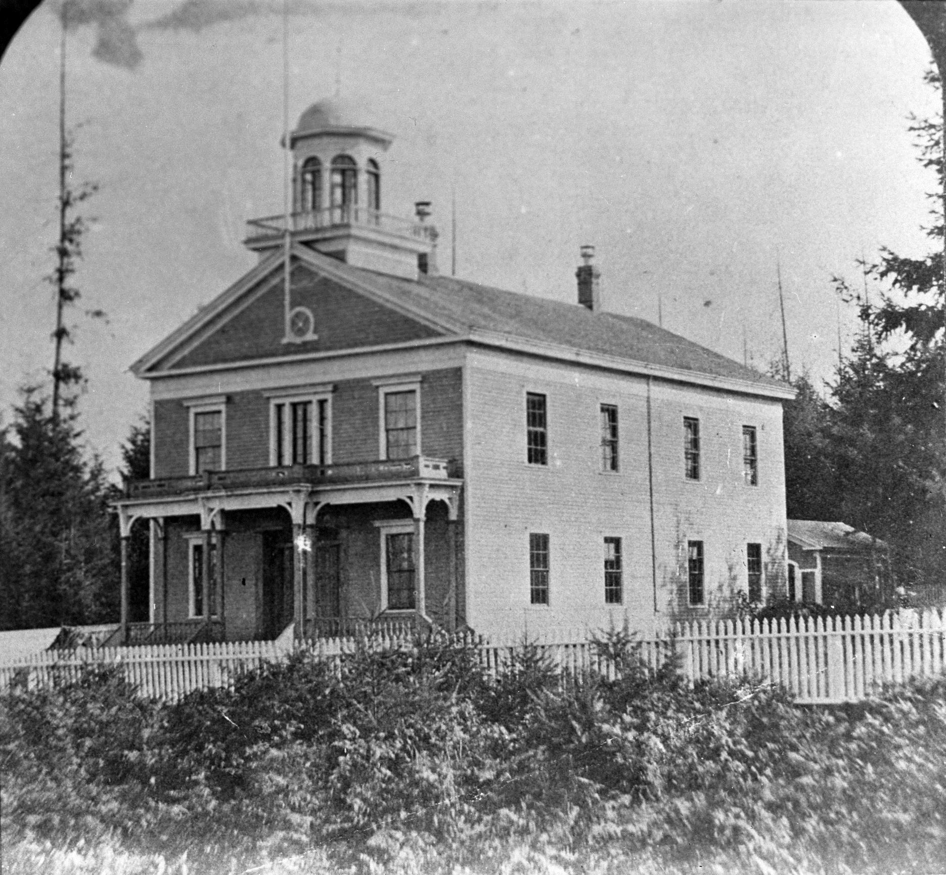
Here,’ a very necessary precaution, without which it would have been impossible to remain in these chambers without risking death by suffocation.”6
It was in this setting that he observed
Detail from an 1879 view of Olympia and environs. Although this drawing was made years after Rossi’s time in the territory, it shows the location of the original Legislative Assembly building (at left, below sailing ship) that Rossi knew so well. Image courtesy of Washington State Library: Bird’s-eye view of the city of Olympia, East Olympia and Tumwater: Puget Sound, Washington Territory, 1879, by E. S. Glover.
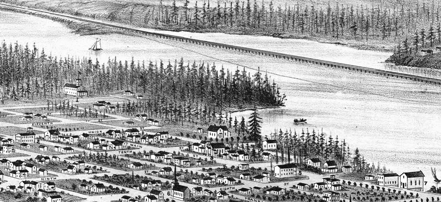
frontier law-making in all its raw boisterousness, and he noted that “. . . I must confess that at the outset I was shocked by what went on. But, all things considered I saw no more than the spirit of independence in action . . .”7 And it seems that this “spirit of independence” made a profoundly positive impression on this cultured European because in his memoir he penned a most admiring picture of America and Americans for his European readers. “[Americans] have maintained the same form of government
for more than eighty years, in spite of political bickering.”8 Then addressing his fellow Europeans he noted that in “our civilized countries . . . we don’t know how to stay at peace for eighty years. Revolutions follow each other without interruption, and we can’t keep any form of government for a short period of time without the use of bayonets . . . In America they have maintained the same form of government without either army, cannons or bayonets, but only through the force of reason and not, as with us, by rea-
son of force.”9
“Perhaps there is no other country with such noble and good laws as America.”10 And then waxing lyrical he remarks “All those who know America, love it. Indeed, how would it be possible not to love such a liberal country?”11
Rossi used his considerable observation skills to form an obviously lasting impression of the village of Olympia. “There are between three and four hundred inhabitants, two churches, one Catholic and one Methodist, both unfinished. There is a big building for legislative sessions and law-courts, there are perhaps one hundred buildings, shops and houses scattered here and there among big felled trees, marshes and sloughs in their pristine state. The streets are still obstructed by fallen trees here, by tree stumps there, a lit-
Detail from an 1856 map showing the street layout of Olympia. The map was produced by Lieutenant Commander J. Alden of the U.S. Navy as part of his reconnaissance of Olympia Harbor for the U.S. Coast Survey. Image courtesy of Washington State Library, Historical Maps Online: 309365918 (accessed May 12, 2017).
tle further on by holes, and even further on, by swamps. It is difficult to get through. You have to ride in a zigzag, and you are pleased if you arrive at the stable without breaking your
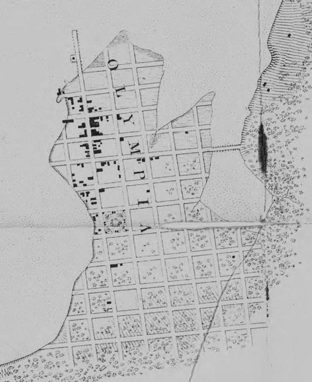
neck, or at the very least, a limb.” Despite his misgivings about the state of its streets, Rossi concluded his description of Olympia with this optimistic assessment: “In spite of this lessthan-encouraging introduction, Olympia . . . is in a position to become a large and important city.”12
Rossi may have been thinking of Olympia when he wrote: “In America, where laws have not yet regulated construction, houses and shops are soon built. This instantaneousness, this vigor in execution is, moreover, one of the particular characteristics of the American people. Go ahead seems to be their favorite expression and the act follows the word. Besides the Americans don’t need much to put together a town; a shop or two, where, as far as goods are concerned, you find everything thrown together in the same place, things you’d hardly find in a hundred shops in our towns; a post office, often set up in the shop; a night club, a doctor’s office with drug dispensary; a hotel, a lawyer’s office that’s all they needed to make a town. After that comes the school, the meeting house which generally doubles as a school, and other more or less necessary buildings. But if the town is a county seat, then you find the courthouse which is frequently used as a church for all religious denominations of every color and creed… But these towns, often of obscure origin, are subsequently developed on a large scale and with a rapidity absolutely unknown to us in Europe. They become important cities in less time than we need to conceive and erect a
As one would expect from a former missionary, Rossi’s vivid images of Thurston County include his very modest Olympia church and a congregation of which many were not in attendance for worship purposes. “[T]he church had no pews for the congregation, no altar, no stove, etc. There were no more than fifteen parishioners including children capable of learning the catechism. Still, the chapel— which measured forty feet by twentyfive was too small to hold the people who did come. Although that was encouraging . . . I knew well enough that these people came only to satisfy their taste for listening to a preacher, of whatever religion.”14
But Rossi was clearly willing to welcome his Olympia congregation regardless of their reasons for attending. “However my audience was welcome, and I tried whilst explaining Catholic doctrine as best I could never to hurt their feelings. To have acted otherwise would have been neither clever, reasonable, nor Christian.”15 But it was not just in Olympia that Rossi’s congregations included more Protestants of various persuasions than Catholics. Despite having spoken English for a relatively very short time, he was a popular preacher, and apparently he knew it. Elsewhere in his memoir he permitted himself a sly bit of selfcongratulation when he observed “One thing is certain, the Americans will always go where the preaching is best.”16
Rossi’s cordiality towards nonCatholics did not extend, however, to one particular Protestant: Olympia’s Reverend John F. Devore, a Methodist minister. The Pacific Christian Advocate, a Methodist organ, printed a lengthy letter in its July 31, 1858 edition the gist of which was that “Romanism, in the person of Rossi (an
Italian who has charge of a mission in the country) is assuming a fearful appearance in this territory.” Rossi replied in a letter published in the Puget Sound Herald a few days later, to which Devore fired back in the same newspaper, and the war was on! It was never resolved to anyone’s satisfaction of course. But Rossi may have won at least a skirmish, with the inadvertent help of ethnographer and civic booster James Swan, an Episcopalian who wrote an article, describing for Californians various compelling aspects of living in Port Townsend, one of which was the presence of Father Rossi. The letter was published in San Francisco’s Daily Evening Bulletin on May 10, 1859.
“Religious teaching, however, is not so readily obtained at present, although the Roman Catholics are building a church here during the coming summer, to be under the pastoral charge of the Rev. Louis Rossi. A wandering Methodist preacher of the most inferior style of address came here, but as the only thing he could do was utter ‘words without knowledge,’ he made but little if any impression on the people. Father Rossi, on the contrary, is an intelligent and highly educated gentleman, with whom it is a pleasure to converse. He is an Italian by birth, and his gentlemanly and agreeable manners have already won him many friends, even among the Protestant portion of the community.”17
And no doubt an editorial, published on November 25, 1859 by the non-

Catholic editor of Steilacoom’s Puget Sound Herald might have added to Devore’s discomfiture. Along with other laudatory comments, Charles Prosch wrote of Rossi: “His amiable manners, his kindness of heart and his zealous endeavors to promote the moral and spiritual welfare of the people have gained him the esteem and confidence of all. Coming as he did, among a population composed of but few Catholics, he has succeeded to a wonderful extent in doing away with the prejudices which most Protestants entertain against the Roman church. . .”18
Rossi’s chronic illness finally became too much for him and on September 13, 1862 he sailed from New York back to Europe. He settled in France where he worked on his memoir until June of the following year. (It enjoyed a second printing in 1864 under the [translated] title of Recollections of a Voyage in Oregon and California.) He then served in various roles in parishes in the vicinity of Paris, the last one being as the pastor of the Church of Saint Sebastian at Ile-Saint-Denis, a municipality on an island in the Seine where, at the age of 54, he died on September 9, 1871. He is buried in the cemetery there.19
Tuomey, Honoria, History of Sonoma County California, Vol. 1. Chicago: The J. S. Clark Publishing Co., 1926.
Wortley, W. Victor, "Perceptions and Misperceptions: A European Cleric's View of the American Indian." Pacific Northwest Quarterly, Vol. 72, No. 4, October 1981, pages 157-161.
1 “Familial Mediterranean Fever is a genetic disorder that causes recurrent episodes of fever that are typically accompanied by pain in the abdomen, chest, or joints.” https:// www.rheumatology.org/I-Am-A/ Patient-Caregiver/DiseasesConditions/Familial-MediterraneanFever-Juvenile (accessed June 30, 2017).
2 W. Victor Wortley, Six Years on the West Coast of America 18561862. Fairfield, WA: Ye Galleon Press, 1983, page 354.
3 Wortley, page 175.
4 Wortley, page 175.
Schoenberg, SJ, Fr. Wilfred P., Paths to the Northwest: A Jesuit History of the Oregon Province. Chicago: Loyola University Press, 1982, page 121.
5 Wortley, page 175. Contained in the Corporation Records of the Washington State Archives is “An Act to Incorporate an Institution of Learning and Charitable Purposes in the County of Clark” dated January 28, 1859. This act states that Sister Joseph “and all persons who may associate themselves with her, and their successors, be, and they are hereby, declared a body politic and corporate, under the
name and style of the ‘Sisters of Charity, of the house of Providence, in the Territory of Washington.’ ” www.digital archives.wa.gov/DigitalObject/ Download/a84e6890-ddbd-4154-8ccd -9ce8122266c8 (accessed June 23, 2017).
6 Wortley, page 134.
7 Wortley, page 134.
8 Wortley, pages 135-136.
9 Wortley, page 136.
10 Wortley, page 93.
11 Wortley, page 138.
12 Wortley, page 124.
13 Wortley, page 85.
14 Wortley, page 133.
15 Wortley, page 133.
16 Wortley, page 128.
17 James G. Swan, Almost Out of the World: Scenes in Washington Territory. Tacoma: Washington State Historical Society, 1971, page 14.
18 “Rev. Father Rossi.” Puget Sound Herald, Steilacoom, WA, November 25, 1859, page 2.
19 Wortley, page 13. __________
In the late 1980s, while participating in the restoration and preservation of the remaining four officers' cottages at Fort Steilacoom (1849-1867), Ray Egan happened upon a copy of Fr. Rossi's recently translated memoir. Upon learning that not only had Rossi been an unofficial chaplain (only Protestant clerics were normally selected to be official chaplains) and that he had been a frequent guest in probably all four buildings, Egan decided to develop a one-man living history performance, using Rossi's own words. After some 200 performances, Egan added pioneers Ezra Meeker, Willis Boatman, and Job Carr to his repertoire, which kept him busy doing another several hundred performances and appearances.
Egan's years as a living history performer were preceded by a career in the U.S. Air Force and over twenty years as a business department faculty member at Pierce College, Lakewood, Washington.
Note: This article is adapted from Maritime Olympia and South Puget Sound, by Les Eldridge and John Hough, Arcadia Publishing Company, 2017.
Maritime history in the southern part of Puget Sound spans eons from the
time when today’s indigenous people arrived on its shore. The topography of South Puget Sound was carved out during the last ice age. As the ice retreated 12,000 years ago, a deep inland sea was created. The entryway into South Puget Sound is the Nar-
A Coast Salish family paddles their canoe just offshore in this view from the late 19th or early 20th Century. Their beautiful canoe with sweeping lines was, as usual, carved out of a single large cedar tree. Photograph by Edward S. Curtis, circa 1900. Photo courtesy of Wellcome Library, London: Iconographic Collection 564530i.

rows, an hourglass neck of swift currents between Tacoma and the Kitsap Peninsula. South of the Narrows, the Sound opens into a string of emerald islands leading to Olympia, the state capital. The resource-rich waters of South Puget Sound continue to serve as a marine highway, playing a major role in the growth of this region.
For many millennia, First Peoples have relied on the resources of South Puget Sound. The beaches and deep waters were an abundant source of food, and the plants and trees on shore gave shelter. Thick forests that surrounded the Sound made overland travel very difficult. However, its protected waters provided a convenient way for indigenous people to harvest fish and shellfish and to visit neighboring villages, which dotted the shoreline.
Collectively, the several tribes of First Peoples who live in the South Sound region are known as Coast Salish. They used canoes carved out of huge cedar trees to travel the Sound. These vessels ranged in size from those for one or two paddlers up to canoes that could carry twenty to thirty people, or considerable cargo. It took a skilled craftsman several months to hollow out a cedar log and then carve the outside into a graceful shape which slid easily through the water. Colorful designs were painted or carved on the sides and sweeping prows of the craft.1
The Coast Salish were master mariners. That skill allowed their sturdy canoes to range all over Puget Sound. These First Peoples traveled with the seasons as salmon runs arrived and berries ripened. They built permanent long houses of large cedar logs and roofed with cedar shingles. During the summer, native families set up temporary camps along the shoreline at spots favorable for gathering berries and other food plants. Clams and mussels were always available when the tide went out. Life was good. But occasionally the tribes had to defend themselves from marauders who swept down from northern British Columbia. Today, fortunately, Coast Salish people of Puget Sound and the former marauders, now the First Nations of Canada, come together annually to celebrate their vibrant common canoe culture.
Traditionally, the First Peoples gathered annually at a village for days of lavish celebration with song, dance, gift-giving, and feasting. The white settlers, however, actively discouraged these potlatches, and the tradition gradually died out. However, during the 1989 Washington State Centennial, Coast Salish people gathered for the first time in generations to celebrate their common heritage. More than a dozen tribes from the region set out from their homes; they paddled to Seattle, often over long distances, and gathered once again. The success of the “Paddle to Seattle” encouraged First Peoples of the United States and Canadian First Nation members to make this gathering an annual event.
Now it is hosted in turn by the region’s tribes, including the Nisqually and Squaxin tribes in South Puget Sound. Nowadays, this gathering frequently draws canoes from almost 100 tribes and bands for a celebration lasting several days.2
The first Europeans to encounter the splendid Salish mariners were Royal Navy sailors in the expedition of Cap-
Top: Captain George Vancouver, Royal Navy, successfully commanded the epic four-year expedition that charted Puget Sound, the straits of Juan de Fuca and Georgia, the Inside Passage and Vancouver Island (1791-1794). Image courtesy of Wikimedia Commons.

Bottom: Vancouver’s ship, the HMS Discovery, was a survey sloop of war, 96 feet long. From a mural in the Lincoln High School Library in Seattle. Image courtesy of Washington State Archives: AR-07890001-ph003925.
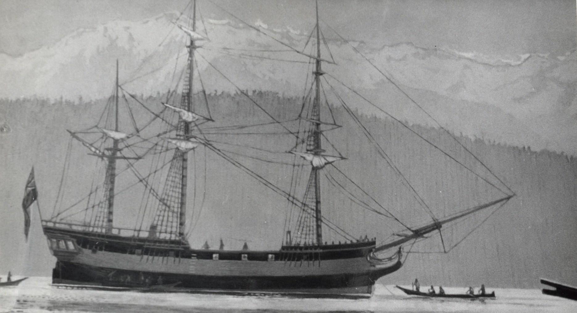
tain George Vancouver, who arrived in May 1792. Vancouver’s purpose was three-fold: to settle with the Spanish a dispute over possession of Nootka Sound on New Albion (later, Vancouver Island), to chart the waters of the Northwest coast, and to reinvestigate the possibility of a Northwest Passage across North America. Captain Vancouver anchored near the future site of Seattle. To the south, he saw the narrow mouth of an inlet. Concerned about taking his ship through that passage, Vancouver sent out a reconnaissance team in two small boats. The party was commanded by his second lieutenant Peter Puget, Sailing Master (navigator) Joseph Whidbey, and naturalist Archibald Menzies. After exploring the southern inlet, Puget and his party determined that there was no Northwest Passage crossing the continent from those waters. The charting of the inlet was so well done that Vancouver honored Puget by naming the southern inlet “Puget’s Sound.” Today, the entire sound bears the name Puget Sound, and the branch explored by Puget is South Puget Sound.3
The British did not return until November 1824, when a 48-man Hudson’s Bay Company (HBC) brigade ventured north from Fort George (later Astoria) to the Fraser River near present-day Vancouver, British Columbia. It was quite a journey. The party crossed the Columbia River in three boats, portaged over a range of hills to Willapa Bay, and continued north to today’s Grays Harbor. They then pulled their boats through the coastal
surf and rowed up the Chehalis and Black Rivers, across Black Lake and portaged to Puget Sound at the head of Eld Inlet. After a long row on Puget Sound they finally arrived at the first rapids of the Fraser River. Chief Factor James McMillan commanded the brigade and one of his clerks was John Work. Also aboard was the first American in these waters, William Cannon.4
A number of posts were established in the Pacific Northwest as a result of the 1824 HBC trip, including Fort Nisqually. That post was sited adjacent to Sequalitchew Creek, near the mouth of the Nisqually River; today that place is the location of the town of DuPont. Fort Nisqually became a key trading post for South Puget Sound, both for settlers and the Salish people, who often found work in the agricultural fields associated with the Fort.
Americans made the next major incursion into Puget Sound, in 1841. The U.S. Exploring Expedition, commanded by Navy Lieutenant Charles Wilkes, surveyed Puget Sound as part of a four-year journey around the world. Wilkes placed 261 American names (for ships, naval heroes, sea battles, and crew members) on geographical features around the Sound. In the Olympia area, this included Budd Inlet (Lt. Thomas Budd) and Eld Inlet (Midshipman Henry Eld), both named for members of his crew. In 1846 negotiations with Great Britain, Wilkes’ charting and naming in the Sound was a factor in the international bor-
This sketch by John Sykes of Lieutenant Peter Puget’s encampment on Puget’s Sound probably shows the May 25, 1792 encampment of Puget, Whidbey and Menzies on the north end of Griffin Peninsula, near Steamboat Island. Their journal described their location on the south shore of Squaxin Passage as in “a very pleasant situation.” The view looks west with the Mason County hills in the distance. Image courtesy of Washington State Archives: AR-07809001-ph004572.

der between Canada and the U.S. being placed at the 49th parallel.5
An extraordinary assembly of adventurous seagoing scientists accompanied these three early expeditions to South Puget Sound and their writings provide an enduring legacy. Vancouver’s naturalist and physician, Menzies, collected many plants and gave his name (in Latinized form) to the ubiquitous Douglas fir (Pseudotsuga menziesii). Later, David Douglas, who explored the Pacific Northwest between 1825 and 1833, became the person from whom the common name
“Douglas fir” originated. John Work, who resided here between 1824 and 1860, and Dr. William Tolmie, a physician and botanist at Fort Nisqually between 1833 and 1860,6 capitalized on their HBC affiliation to enhance the world of botany and zoology. Also, the Wilkes Expedition included eleven scientists. Their collection of specimens from around the world, between 1838 and 1842, caused the Smithsonian Institution to build its “Castle” in order to house many thousand scientific items. Most of Wilkes’ scientists spent time in South Puget Sound and lent their names to its geography. They in-
clude volcanologist James Dwight Dana, naturalist/artist Titian Peale, linguist Horatio Hale, botanist William Brackenridge, naturalist Charles Pickering and artist Joseph Drayton.7
These hardy, venturesome men brought Puget Sound to the attention of the world. The subsequent influx of settlers and entrepreneurs changed the quiet waters of Puget Sound into a major marine highway.
Washington became a territory in 1853 and Isaac Stevens was appointed its first governor. Stevens was a West Point graduate, an officer in the elite U.S. Coast Survey, and a future Civil War general. He was an ambitious, driven man, and these attributes helped bring turmoil, warfare and injustice to the new territory. Stevens forced First Peoples to sign treaties they only marginally understood, then placed them on reservations unsuited to their form of livelihood, whether or not they had signed the treaties. When the First Peoples realized what was happening, an armed uprising resulted in 1855. The U.S. Army, Navy and Territorial Militia responded with force, overwhelming the uprising. Several years after the fighting ended, a dispute over ownership of the San Juan Islands almost led to a shooting war between the British and the United States. It was narrowly averted by negotiations among members of the British and U.S. armed services. Troops from Fort Steilacoom, near the South Sound town of Steilacoom, were
sent north by ship and played a key role in the dispute. Many of the Americans involved were soon fighting against each other in the American Civil War.8
In the 19th Century, the Puget Sound country was still heavily forested and most areas lacked good roads. As a result, water transportation was the most practical way to carry people and goods up and down the Sound. Beginning in the 1850s, a growing fleet of small steamships, eventually numbering in the hundreds, moved between towns along the Sound, churning and buzzing their way around, earning the title “Mosquito Fleet.” Colorful and competitive captains raced at every opportunity, striving for the reputation as the fastest and most dependable boat on the water highway. Olympia was the southern terminus of a web of steamship routes that extended to every corner of the inland sea. Propelled by stern- or side-wheel paddles, or by screw propellers, their bellowing steam whistles shattered the silence of the often placid Puget Sound waters, and their presence engendered construction of docks, shipyards, and navigation-dependent businesses. The steamship companies engaged in rate wars, undercutting each other’s prices in an attempt to gain a bigger share of the market. The Mosquito Fleet was a vital part of the region’s economy until the 1920s, when new roads and motor vehicles made the little steamers obsolete. Those ships were splendid vehicles on the superhighway that was the Puget Sound, and they live vividly in the history of Washington State.9
Three Mosquito Fleet steamers are at Percival’s Dock in the 1890s. Northern Light (left) was built for the Yukon River, but never got north of La Conner. Here she ran in competition with City of Shelton, shown in the middle, on the Olympia-Shelton run. Moored inboard to the dock is Multnomah. She was brought around from the Columbia River in the early 1890s and served for many years on the OlympiaSeattle run. Photo courtesy of Washington State Archives: AR-07809001-ph005121.

STATE CAPITAL SEAPORT: DEVELOPING WORLD TRADE 1857-1973
Ocean-going sailing vessels and Mosquito Fleet steamers served a growing Olympia. The capital city got its start as a port in 1857 when Benjamin F. Brown built a wharf into Budd Inlet from the donation land claim of his neighbor, George W. French. Located
in deep water at the place where the Old Port community now exists, Brown’s Wharf became the primary conduit for outbound goods: the famous Olympia oyster, milled wood, local fruit, and coal. Sailing vessels and small steamers brought in consumer goods and rail for local railroad construction. Access to the west side of Olympia was poor, so the city com-
missioned a road to Brown’s Wharf. It crossed George W. French’s land and now is known as French Road.10
Brown’s Wharf was busy with sailing vessels and small steamers coming and going. But ocean-going steamers were deterred from calling at the capital city by extensive mudflats reaching out into Budd Inlet. In 1874, the captain of a Goodall, Nelson and Perkins steamer came up from Tacoma, the southernmost port for ocean-going vessels, to tell an Olympia paper they could not call because of the mud flats. The paper’s editor then shamed the city fathers into building a pier almost a mile long, extending from Main Street over the mud flats to deeper water. With the new pier providing direct access into Olympia, Brown’s Wharf came to be called “Old Port,” the name now used by the residential community there.11 But ocean-going steamers still did not call at Olympia.
In 1853, Captain Sam W. Percival and his wife arrived in Olympia. Percival built a small sawmill at the mouth of what is now Percival Creek; soon thereafter he started work on a dock adjacent to Olympia. From 1877 to 1934 Percival Dock was the main wharf for Mosquito Fleet steamers and other vessels calling on Olympia. Percival and his son were agents for several steamship lines. Among them were Goodall, Nelson and Perkins (the predecessor of the Pacific Mail Steamship Company), Oregon Railway and Navigation Company, and Northern Pacific Steamship Company.12
While Olympia was connected to Tacoma and Seattle by small steamers (and hence to San Francisco and the wider world), larger vessels still could not call at Olympia because of the mud flats. But at the turn of the 20th Century, extensive dredging deepened the harbor and provided a practical oceanwide outlet for local goods.13
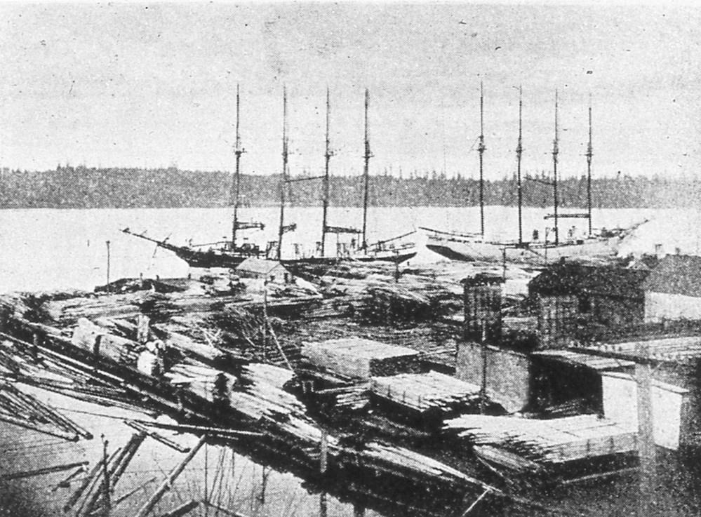
Timber products were, as today, a major portion of the economy in the Olympia area. By 1922, 30 lumber mills, five shingle mills, and a veneer plant occupied the shoreline near Olympia. In addition, local farms grew a wide variety of berries, which were canned for shipment. Olympia Beer, brewed in nearby Tumwater, and succulent Olympia oysters were also shipped to worldwide customers.
In order to boost commerce, the voters of Thurston County created the Port of Olympia in 1922. The Port promptly began building piers in Budd Inlet along the new upland created with dredge spoils. Soon, ocean-going steamers began calling on Olympia. In 1927, a total of 90 vessels tied up to the Port’s docks.
In the early 1930s, new Port of Olympia facilities were built under the authority of President Roosevelt’s New Deal. The sailing frigate USS Constitution came to Olympia in 1933. The visit was part of a national tour to thank the public, especially children, who donated pennies toward funding the restoration of the old warhorse from the War of 1812. The frigate was nicknamed “Old Ironsides” because British
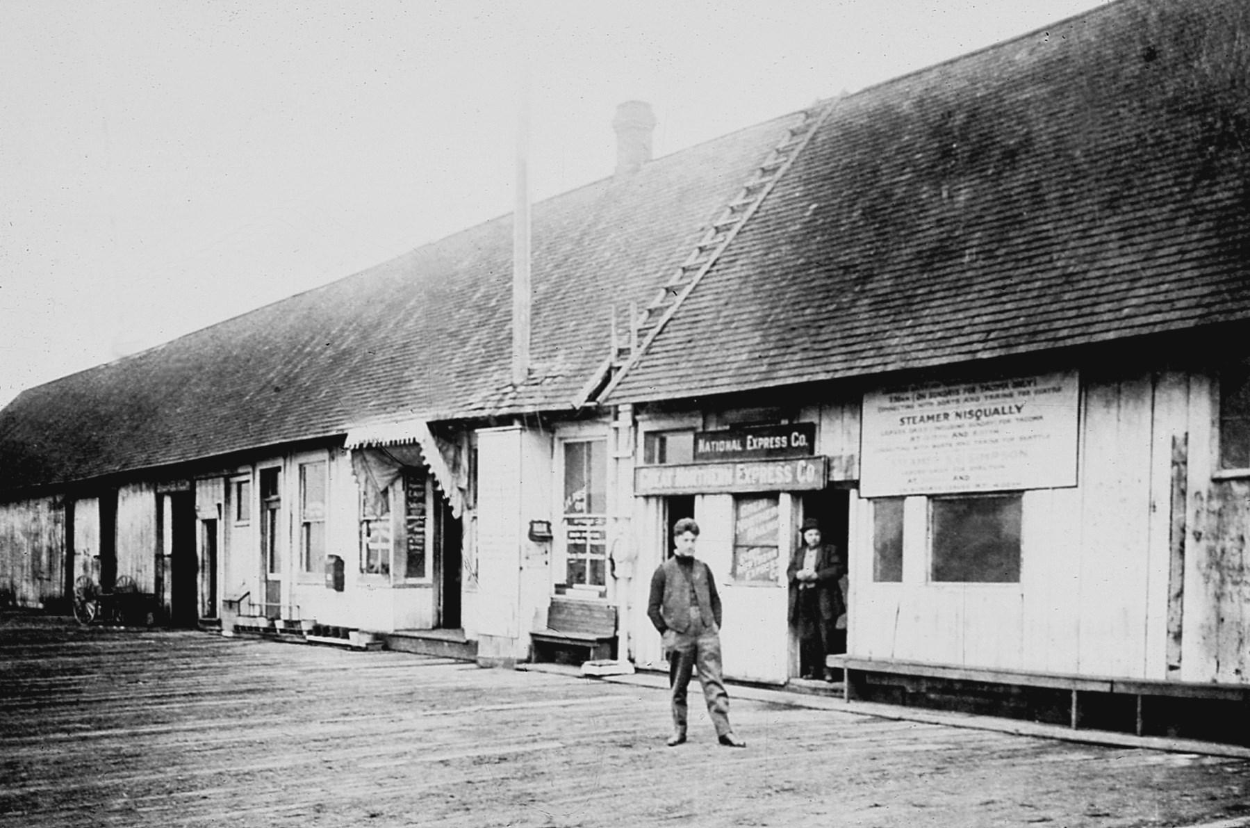
Below: The dock built at Olympia by Sam Percival and his son in the 1860s was the hub of commerce on South Puget Sound. In addition to the many steamers calling there, numerous companies had their headquarters on the dock. National Express, a shipping company, was one. Sam’s son, John, is probably the man pictured in the foreground. The man standing in the doorway is unidentified. Photo courtesy of Washington State Archives: AR07809001-ph000896.

This invoice was issued from Percival’s Dock (then owned and operated by John C. Percival, Sam’s son) to the Olympia Brewing Company in 1907. One box of cigars was carried as freight on board the Greyhound, a sternwheeler which at the time ran between Olympia and Tacoma. Image courtesy of Olympia Tumwater Foundation: Leopold F. Schmidt Papers, Box 2.

shot just seemed to bounce off her stout oak sides.
During WWII, the Port shipped large amounts of lend-lease equipment and material to Russia. After the war, Budd Inlet became home for a naval reserve fleet of mostly freighters, called the “Mothball Fleet.” Several vessels were reconditioned for service during the Korean and Vietnam wars. But gradually, the reserve ships were
scrapped and by 1972 the last one had been towed away. During the Korean War, the Port began a long relationship with nearby Fort Lewis, shipping men and equipment to the Far East and then to other areas of conflict around the world.
Lumber shipments continued to be the Port of Olympia’s mainstay cargo during the 1950s. In 1956 alone, 161 million board feet of lumber were han-
dled. Two gantry cranes were installed in the early 1960s, expanding the range of cargo handled.14
The 1970s saw adoption of containers for transportation of cargo by ship. While larger ports such as Seattle and Tacoma repurposed themselves to handle containers, the Port of Olympia focused on cargo not suitable for the big boxes. Nonetheless, wood products remained a major focus, with log exports accounting for 98 percent of the Port’s maritime business during that
period. The Port also continued to expand its market by handling a wide range of cargos, as it does today. Currently, the Port continues its close relationship with nearby Fort Lewis, now part of Joint Base Lewis-McChord, handling shipment of military vehicles and supplies around the world.15
Numerous naval vessels have paid port calls at Olympia over the years. In 1919, President Woodrow Wilson’s Pacific Fleet Review flagship, the battleship USS Oregon (BB-3), visited Olympia’s harbor.16 In the 1980s, the USS Olympia (SSN-717), a Los Angelesclass nuclear attack submarine, paid
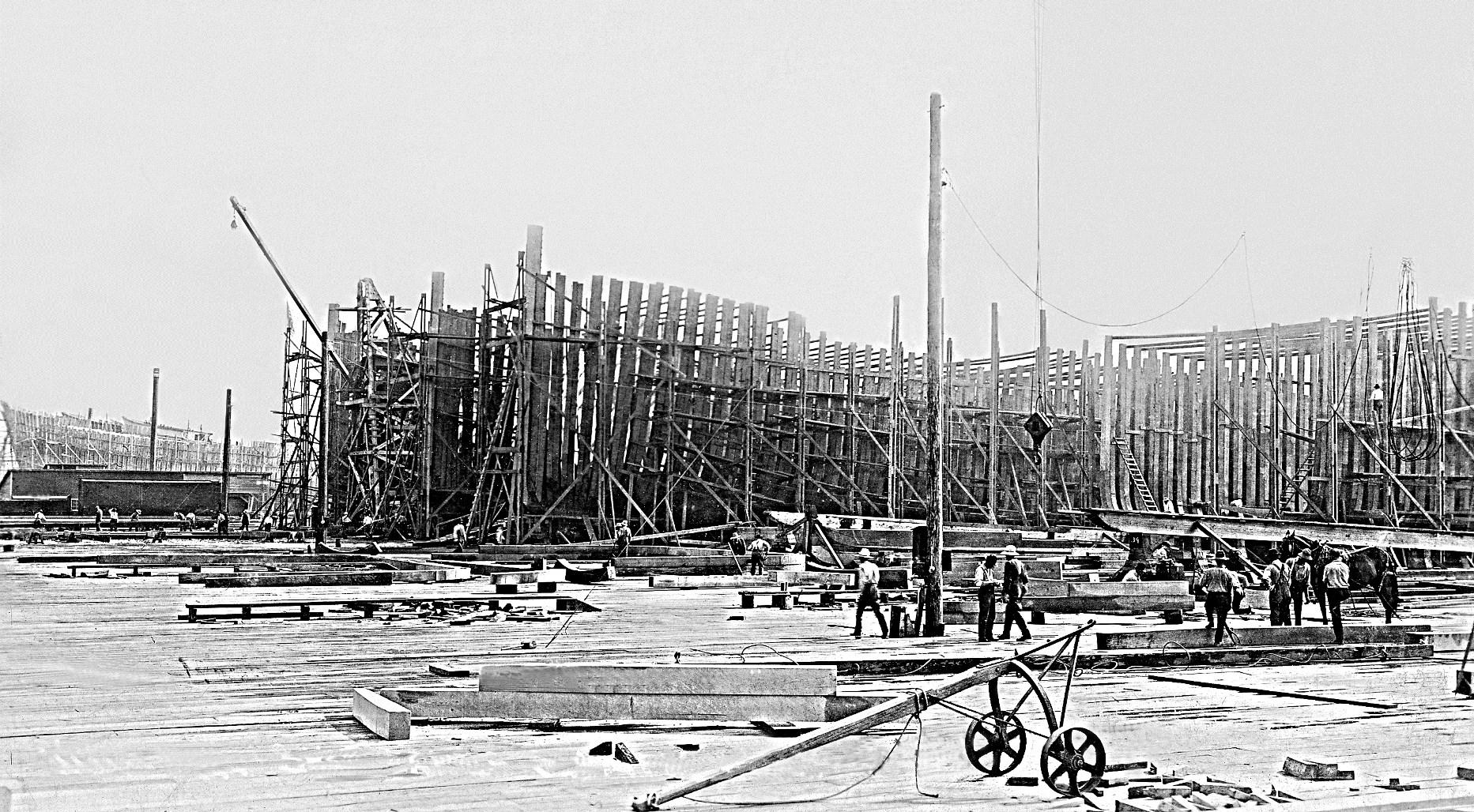
Shipbuilding was widespread in South Puget Sound. Among the most notable yards were Ward’s and Olympia Shipbuilding Company on Budd Inlet, where schooners were built in 1917 for America’s World War I effort. The site was constructed on materials from the Carlyon Fill. The popular site was later home to Sloan Shipyard, shown here. Photo courtesy of Port of Olympia.
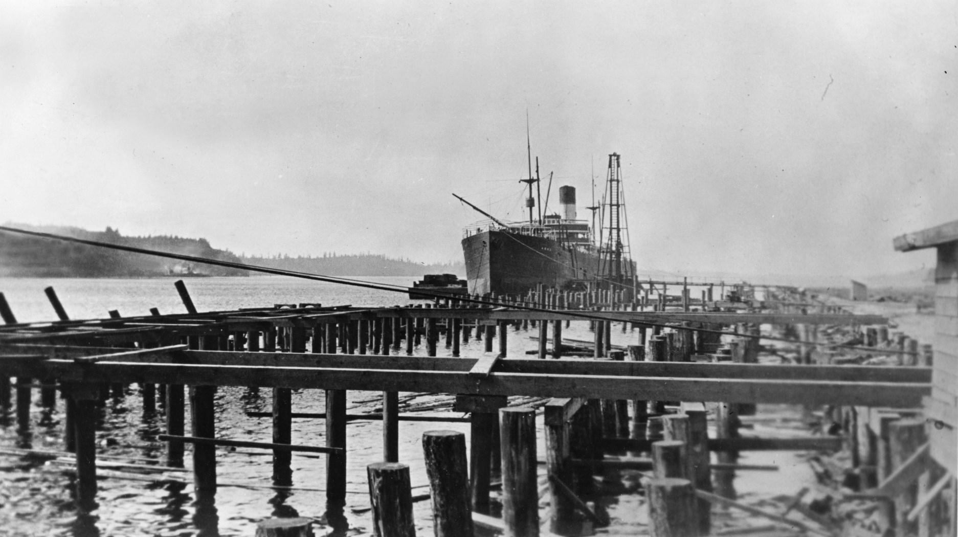
With the creation of the Port of Olympia in 1922, construction began of a pier and cargo storage facilities. The Port facilities were built on a peninsula formed by the spoils from earlier dredging operations. However, ocean-going ships did not wait until the pier was completed. MS Saginaw was the first vessel to call at the Port, the pier still under construction. The steamer loaded 70,000 board feet of finished lumber. By 1924, Olympia boasted 30 lumber mills, five shingle mills, and a veneer plant. Photo courtesy of Port of Olympia.
a port call.17 Japan’s Maritime Defense Force sail training vessel, the fourmasted barque Nippon Maru, made a 1989 visit to Governor Booth Gardner during the State Centennial celebration.18
Historically, South Puget Sound has been a marine highway for transporting people and goods. More recently, as Olympia and its environs grew, recreational boating has become an important part of this region’s economy. Budd Inlet is home to several private
marinas as well as one operated by the Port of Olympia. The Olympia Yacht Club was formed in 1904 by boating enthusiasts; it still sits at the head of Budd Inlet.
Olympia’s Harbor Days has become the signature event celebrating the maritime heritage of South Puget Sound. That festival began in 1974 when the owners of several historic tugs, steamboats and sailing ships brought their vessels to Olympia to make a public display of the South
Sound’s maritime past. The next year, a Labor Day weekend tradition began with the now annual tugboat races, sponsored for many decades by the South Sound Maritime Heritage Association (more recently by the Olympia Kiwanis Club). Continuing today, the tugboat races commemorate bygone
days when tugs raced out to incoming sailing ships, in order to win the right to tow those large vessels into port. Since 1979, a popular arts and crafts fair has been held in conjunction with the display of the historic tugs on Saturday, and races on Sunday, attracting up to 50,000 visitors.
Powerboats jockey for position at the starting line on June 26, 1928, for the longest, most ambitious powerboat race ever staged by then. The “Capital to Capital” race from Olympia to Juneau covered 1,000 miles through the Inland Passage. Adolph Schmidt of the Olympia Brewing Company and businessman John Pierce organized the predicted-time race. It was the first race run under sanction of the Pacific Coast division of the American Powerboat Association. Photograph by Maurice Anderson.
Foundation.

After World War II, the Olympia Reserve Fleet with its mothballed ships was a major fixture in Budd Inlet for several decades. With the end of the war, the U.S. Navy had thousands of ships that were no longer needed. Some were quickly scrapped, but hundreds were placed in mothballs in harbors on both coasts in case they were needed again. In 1946, a Reserve Fleet was established in Gull Harbor, just north of Olympia. Rafted together were over a hundred transports, tankers and other vessels kept in top condition by the U.S. Maritime Administration. Many of these vessels were called back into service during the Korean War, the Suez Canal Crisis and the Vietnam War. During the middle 1950s, some of the ships were used to store bumper crops of wheat. By July 1972, the last of these vessels was towed away for scrap. Photo courtesy of Olympia Tumwater Foundation.

For thousands of years, South Puget Sound has been a rich resource for the necessities of life. Its waters and
tidelands supported the Coast Salish peoples. Now, these natural resources are shipped worldwide. The deep water
The annual Olympia Harbor Days festival continues from its start as a meeting of tugs in 1975. Here, tugs charge up Budd Inlet during an early Harbor Days race. The classic tug Sand Man is holding her own against her newer class competitors.

of these inlets has been a marine highway since the First Peoples arrived here, first by cedar canoes, then via the Mosquito Fleet, and now by means of large, ocean-going freighters. With this rich history, South Puget Sound continues to play a major role in this area’s cultural, commercial, and recreation experience.
1 D. Horr, A. F. Drucker and E. Gunther, American Indian Ethnology, Coastal Salish and Western Washington Indians. New York: Garland Publishing Co., 1974; Leslie Lincoln, “Coast Salish Canoes: Development and Design.” The Sea Chest, Seattle:
Puget Sound Maritime Historical Society, December 2016, pages 57-65.
2 Wayne Suttles, Coast Salish Essays. Seattle: University of Washington Press, 1987, pages 224-226; Philip H. Red Eagle, “Origins and Outcomes: Tribal Canoe Journeys,” The Sea Chest, Seattle: Puget Sound Maritime Historical Society, December 2016, pages 66-75.
3 Edmond S. Meany, editor, Vancouver’s Discovery of Puget Sound. Portland, OR: Binfords & Mort Publishers, 1957; Report of George Vancouver, A Voyage of Discovery to the North Pacific Ocean and Round the World 17911795, 1798, pages 129-147; Robert C. Wing and Gordon Newell, Peter Puget. Seattle: Gray Beard Publishing, 1979, pages 45-72.
4 Murray Morgan, Puget’s Sound A Narrative of Early Tacoma and the Southern Sound. Seattle: University of Washington Press, 1979, pages 20-23; John Work, John Work on the Chehalis. Herbert C. Taylor, Editor. New York: Clearwater Publishing Company, 1954.
5 Nathaniel Philbrick, Sea of Glory America’s Voyage of Discovery, The U.S. Exploring Expedition, 1838-1842. New York: Viking-Penguin Group, 2003, pages 265-277; Frances B. Barkan, Les Eldridge and Drew Crooks, The Wilkes Expedition, Puget Sound and the Oregon Country. Tacoma: Washington State Historical Society, 1987; Richard W. Blumenthal, Mari-
time Place Names Inland Washington Waters. Bellevue, WA: Inland Waters Publishing Company, 2012, page 49 (Budd Inlet), page 96 (Eld Inlet).
6 Tolmie State Park is named after Dr. Tolmie. wdfw.wa.gov/fishing/ shellfish/beaches/280080 (accessed May 9, 2017).
7 Barkan; Blumenthal, page 75 (Dana Passage), page 194 (Peale Passage), page 123 (Hale Passage), page 46 (Brackenridge Passage), page 196 (Pickering Passage), page 87 (Drayton Passage).
8 Robert. E. Ficken, Washington Territory. Pullman, WA: Washington State University Press, 2002, pages 44-53, 57-58; Lorraine McConaghy, Warship Under Sail The USS Decatur in the Pacific West. Seattle: University of Washington Press, 2009, pages 109160.
9 Jean Cammon Findlay and Robin Paterson, Mosquito Fleet of South Puget Sound. Charleston, SC: Arcadia Publishing, 2008; Gordon R. Newell, Ships of the Inland Sea The Story of Puget Sound Steamboats. Portland, OR: Binfords & Mort Publishers, 1960.
10 Shanna Stevenson, Superior Shipping Service A History of the Port of Olympia. Olympia: Port of Olympia, 1982, page 7.
11 Washington Standard, Olympia, June 26, 1875; Stevenson, 5; Carol Davidson, Sue Funkhauser, and Bill
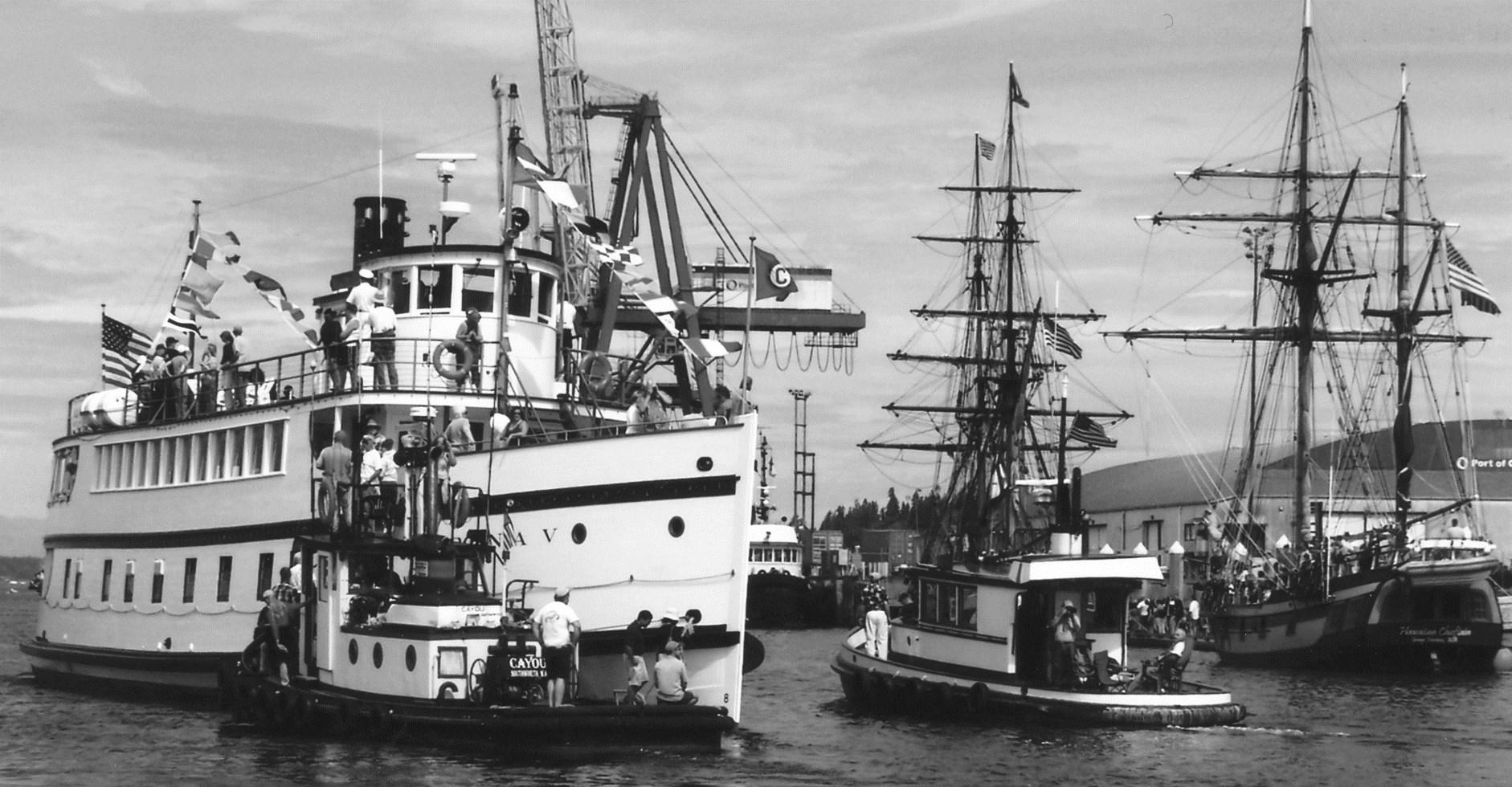
A festive Harbor Days celebration featured a visit by the vintage steamer Virginia V up from Seattle. Built in 1921, she is one of the last survivors from the days of the Mosquito Fleet. In the background is the tall ship Hawaiian Chieftain and beyond her the masts of Lady Washington, a replica of the consort of Captain Robert Gray’s ship Columbia Rediviva on his discovery of the Columbia River for America. Photograph by Karla Fowler.
McCrea, editors, How the West Was Once A History of West Olympia. Olympia: n.p., 1974, pages 35-36.
12 Stevenson, page 8; Davidson, page 38.
13 Stevenson, page 8.
14 Stevenson, pages 3-30.
15 Stevenson, pages 31-35.
16 USS Oregon. 1919. Photograph.
Olympia-Tumwater Foundation.
17 USS Olympia. 1986. Photograph. Port of Olympia. She is the second naval vessel to be named after Olympia, the first being the protected cruiser USS Olympia, Commodore Dewey’s flagship at the Battle of Manila Bay in 1898 during the Spanish American War. John Hough, “State of Washington Naval Ship Names.” The Sea Chest, Seattle: Puget Sound Maritime Historical Society, December 2015, pages 49-50.
Port of Olympia.
Les Eldridge has taught regional maritime history and lectures widely on the subject. He is co-author of The Wilkes Expedition: Puget Sound and the Oregon Country. Les has also written five historical novels of the Civil War at sea. He is president of the South Sound Maritime Heritage Association. Les is a co-author of an in-progress history of Thurston County.
John Hough is a retired attorney and a native of the Puget Sound region. He is author of several articles on regional maritime history and is past president and long-time board member of the Puget Sound Maritime Historical Society. John is writing a biography of Jefferson Davis Howell, a brother-in-law of the Confederate President and famous West Coast steamship captain.
Although coal is becoming less important in the 21st Century U.S. economy, it was a growing industry in this region 100 years ago. Perhaps the most important factor stimulating the increased use of coal, back then, was development of an efficient system of transportation and distribution. County roads were being improved, making wagon delivery of locally-mined coal feasible. Of greater significance was the presence of railroads, making it possible to ship bulk coal economically to distant locations. In that capacity, several Thurston County logging railroads also served as the originating carrier for carloads of coal.
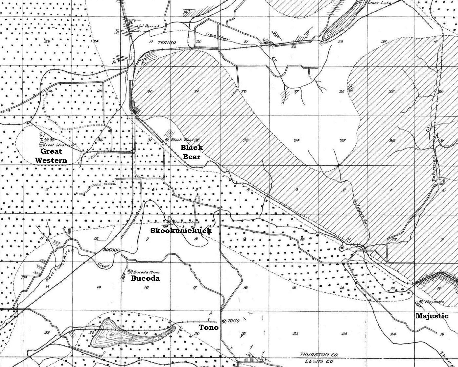
This article will examine the six major coal-producing sites in Thurston County: the region east of Bucoda, the Black Bear Mine, the Great Western Mine, the Skookumchuck Mine, the Majestic Mine, and the largest one, the Washington Union Coal Company Mine at Tono. Keeping track of the various
operators at these sites can be difficult, for the coal business has always been cyclic. Names for the companies operating at these sites have changed frequently, and often, individual mines were closed for periods of time, sometimes for years, before reopening when demand picked up.
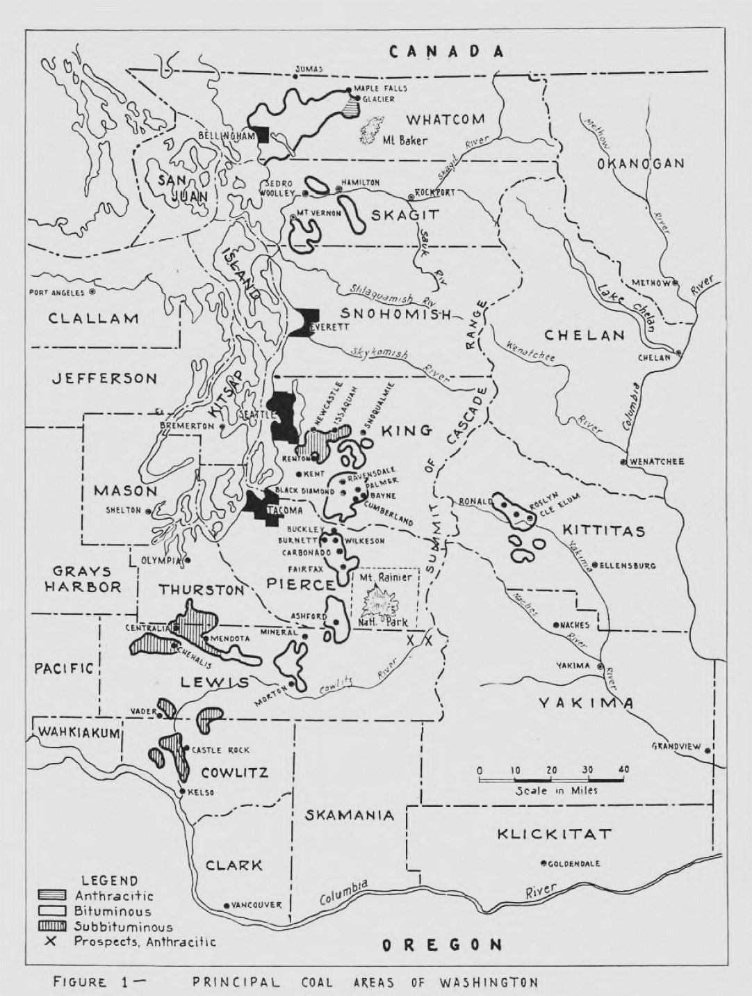
Geologically, coal deposits exist in a belt running north to south, primarily
on the west side of the Cascade Mountains. This is illustrated in Figure 1. In Thurston County, coal was first discovered in the valley of the Skookumchuck River in 1855.1 The primary mining sites in that county are illustrated in Figure 2. A complete list of Washington coal mine maps available for download from the Washington Department of Natural Resources can be accessed at: <https://fortress.wa.gov/
dnr/adminsa/DataWeb/coalmine maps.htm>.
The earliest commercial mine at Bucoda was opened at a time when the community was still called Seatco. In 1877, the Territorial Legislature contracted to house prisoners at a new penitentiary in Seatco. That facility was owned by a consortium consisting of Oliver Shead, William Billings (Thurston County Sheriff), and Jeremiah K. Smith (a former Pierce County Sheriff). Shead contributed land and
the lumber used for buildings. Many of the prisoners who were confined there between 1878 and 1887 were forced into unpaid labor in a sawmill owned by Shead. Commencing in 1880,2 inmates were also required to work in the consortium’s nearby coal mine. Later, that mine became inactive, but it was reopened in 1887 under the ownership of the Northwestern Coal & Transportation Company.
The Northwestern Coal & Transportation Company was the recipient of a spur (called the Bucoda Coal Spur) from the Northern Pacific Railroad in


the fall of 1886. Although the switch at this location was present for almost 70 years, the track scheme of the associated spur changed radically over time. The Bucoda Coal Company was organized in October 1889. Its only initial function was to act as the Portland agent for the sale of coal produced by the Northwestern mine.
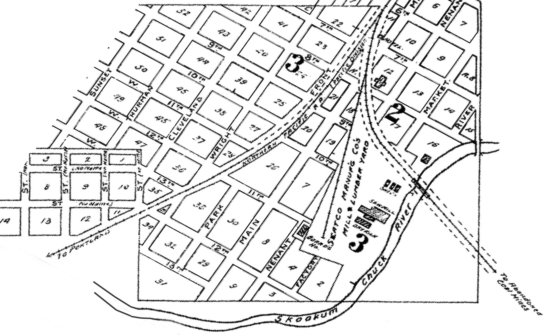
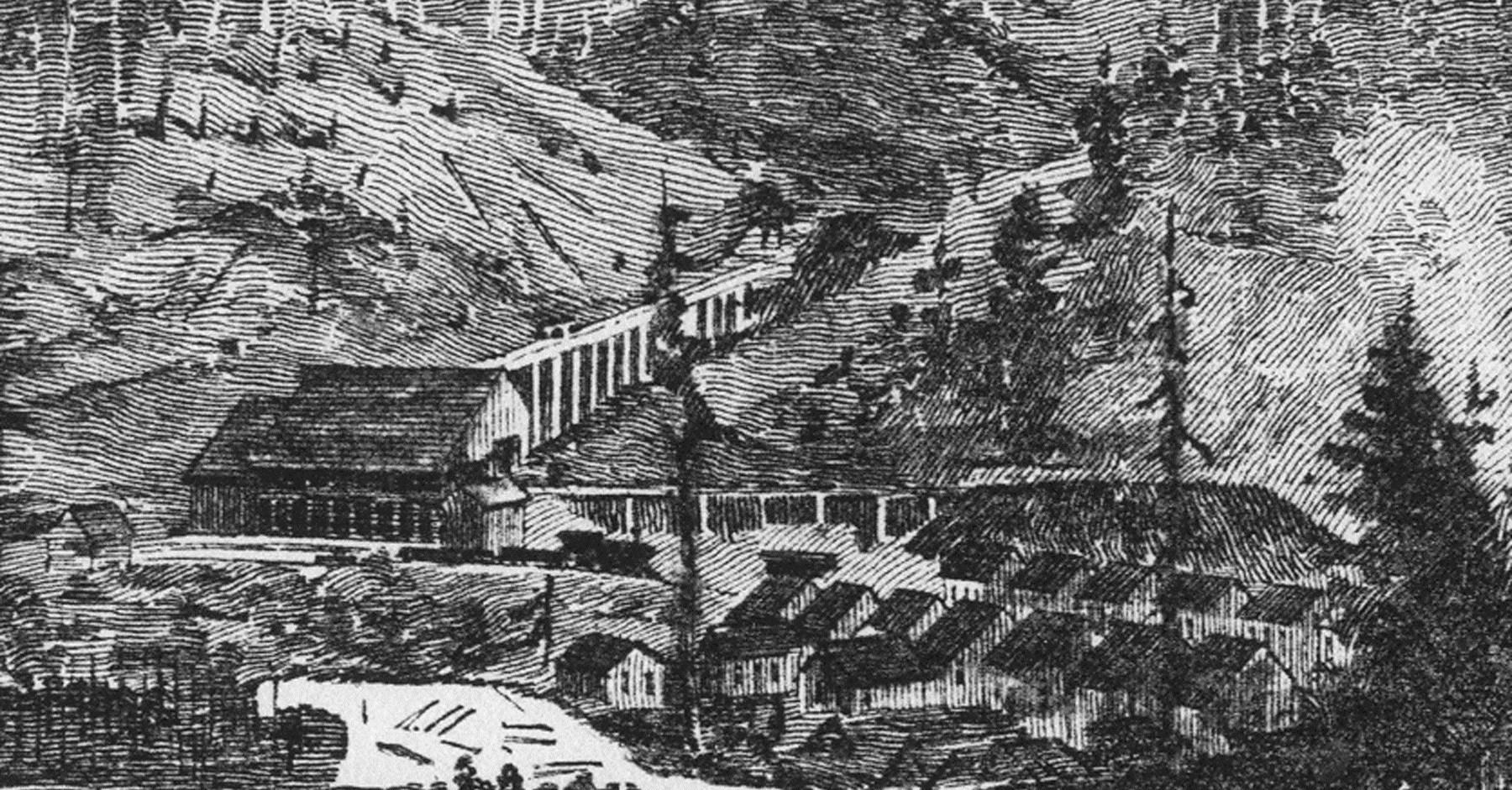
The Bucoda Coal Spur and the Northwestern Coal & Transportation Company tipple, where coal was loaded into rail cars, are visible in Figure 3. Bucoda appeared in the 1890 magazine article illustration seen in Figure 4, and the area of the tipple is enlarged in Figure 5. The mine produced low
quality coal, and operated sporadically. It closed permanently after 1895. Figure 6, produced in 1896, confirms that the mine was inactive. However, the Bucoda Coal Company Spur continued to exist.
An appeal heard by the Washington Supreme Court in 1893 provides insight into Bucoda mine conditions of that era. The case under appeal involved a boy of thirteen years, who was employed by the mine as a screener in March of 1888, when he was injured. He testified that “Ismay, the superintendent, called me and his son, a boy of my own age, from the place where we were working, to run a

few cars down to the scales to weigh them. He gave me a stick to put in the brake of the car so I could manage it. He said: ‘Take this stick and drop that car down; the brake is not good.’ I knew nothing about the brake. Had run other cars down the same way, but not with a stick. Put the stick through the spokes of the brake wheel and used it as a lever. The other boy helped by taking hold of the other side of the wheel. We let the car down about twenty feet to the scales. I put my whole weight against the stick and it broke, and I fell upon the ground in front of the car and was stunned, as I struck on my head. Knew nothing more until I got out from under the car and


found my hand crushed. Ismay was there within ten or fifteen feet of me,
and he took me on his back and carried me home. When my father came in he was blaming me for it, and Ismay said: ‘Don’t blame the boy; I was to blame for it. I told him to brake the car down, and gave him the stick to brake it down with.’ ”
Under cross examination, the boy said, “The car was not running fast. The front truck only passed over me; then it stopped. It was necessary to have the brakes set to keep cars from running down. We loosened the brake, then the car started, ran about its own length and stopped. [I] Had been discharged and reemployed by the company twice before the accident, and again afterward. Ismay said the first two times that it was because I was lazy; the last time was because I was not able-bodied. Was not in the habit of leaving my work and getting on the cars for a ride. Didn’t know that anyone was behind the car pinching it ahead with a crowbar. There might have been another car behind the one I was on. If the stick had not been rotten I would not have fallen.”3 Obviously, great improvements in workplace safety and child labor law have taken place since this incident occurred.
Coal mining resumed near Bucoda in 1914. The Bucoda Coal Company began to produce coal there itself, no longer serving merely as a sales agent. The Sunshine Mine, subsequently designated as the Bucoda Coal Company Mine #1, was located immediately north and east of the old Northwestern Mine. There is reason to believe that Ralph Graham and a brother, to-
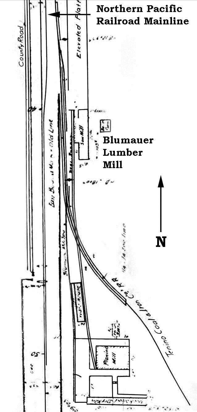
gether called the Graham Brothers, operated the Sunshine Mine in 1915. Mine #1 appears in Figure 7, part of a 1923 Department of Natural Resources map. Figure 8 is a 1927 Army Corps of Engineers map which demonstrates that the original bridge over the Skookumchuck River, used by the Bucoda Coal Spur, had been replaced
by another bridge a bit farther to the south. Circa 1919, the Mutual Lumber Company railroad began operating over the Bucoda Coal Spur, which passed through the Bucoda Coal Company tipple. A precise date for the closure of #1 has not been ascertained. It was no longer operating in 1943.4
The Great Western Coal Development and Mining Company opened its mine in 1903. It was located approximately two miles southwest of Tenino; the entrance was placed at the base of a small hill, where there was an outcropping of The company leased a way between the mine and the mainline of the Northern Pacific Railroad; rails used on that right-of-way were leased from Railway and Steel Supply Company. Figure 9 shows the position of the mine, in Section 35 of Township 16 North, Range 2 West.
The mine was operated vigorously for a couple of years and then diminished. The Pacific Coast Coal Company worked the mine in 1907; later the Keystone Coal Company was the operator. Finally, the King Coal Mining Company worked there for one year
before a receiver was appointed for the bankrupt mine’s assets.6 W. D. Hofius & Company, of Seattle, purchased those assets and resold them in 1911 to Franklin Umstead of Chicago. The inventory included 890 30-foot rails, 50 mine cars, one small locomotive in poor condition, eight houses in good condition, seventeen houses in poor condition, the railroad right-of-way, and ties. After 1911, the eastern part of the right-of-way was reused by Polehn Brothers, who were setting up a lumber mill approximately 0.75 mile southeast of the mine entrance. That lumbering operation became the Badger Lumber Company in 1916.
The Tenino Coal & Iron Company leased coal-mining rights south of Tenino from Isaac Blumauer in 1904. Blumauer retained the right to operate a logging railroad over the leased property. Subsequently, the
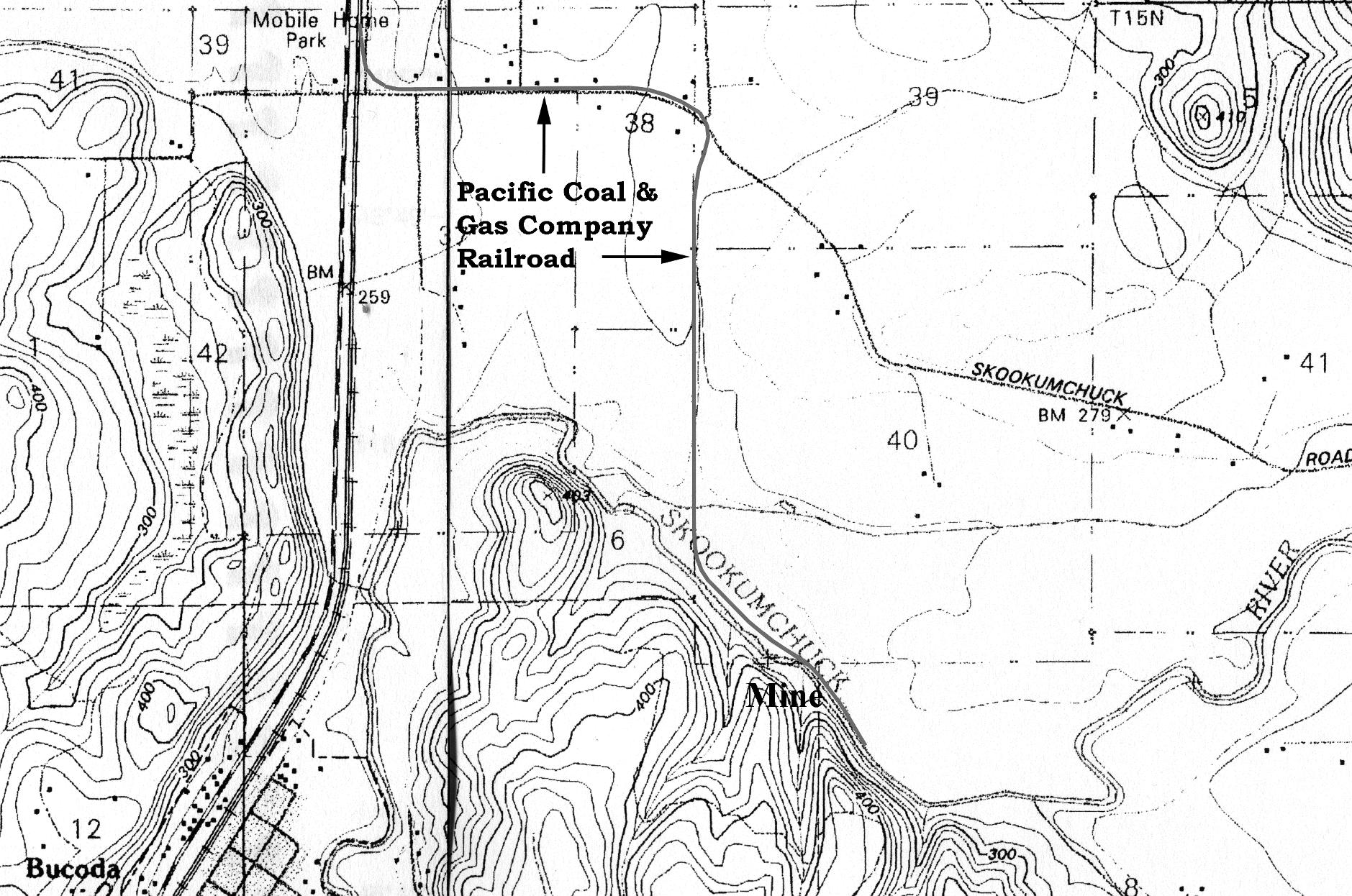
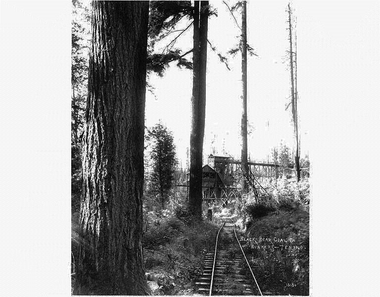
Northern Pacific Railroad put in a spur for the use of the Coal & Iron Company. A diagram of that spur is presented in Figure 10. With access to the Northern Pacific assured, the Black Bear Mine opened in 1907. Its approximate site is visible in Figure 2, although a Washington Geological Survey publication locates it in the northeast quarter of Section 31, Township 16 North, Range 1 West.7 The mine’s bunker is seen in Figure 11. The Tenino Coal & Iron Company operated at this site for two years. In 1911, Graham Brothers opened a new slope there.
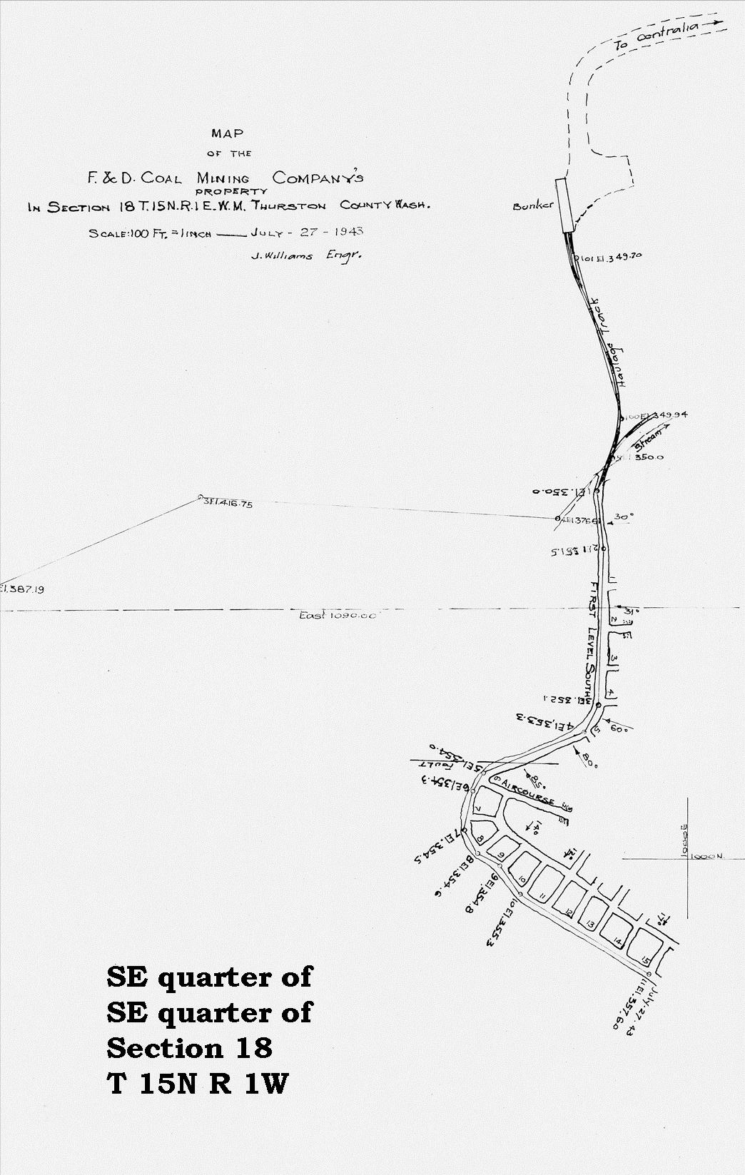
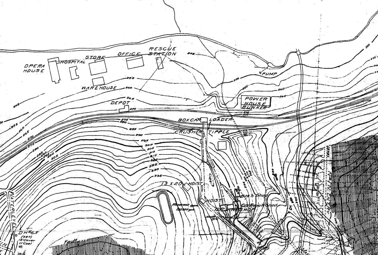
Farther southeast along the logging railroad built by Isaac Blumauer, the Majestic Mine began producing coal in 1911. It appears in Figure 2, and was located in the southwest quarter of Section 18, Township 15 North, Range 1 East. The mine operated only during 1911.8 Mining in that area resumed years later by the F & D Mining Company, operated by John Fusco. By that time, the logging railroad was gone and output must have come out by truck. Figure 12 illustrates the mine’s configuration in 1943.
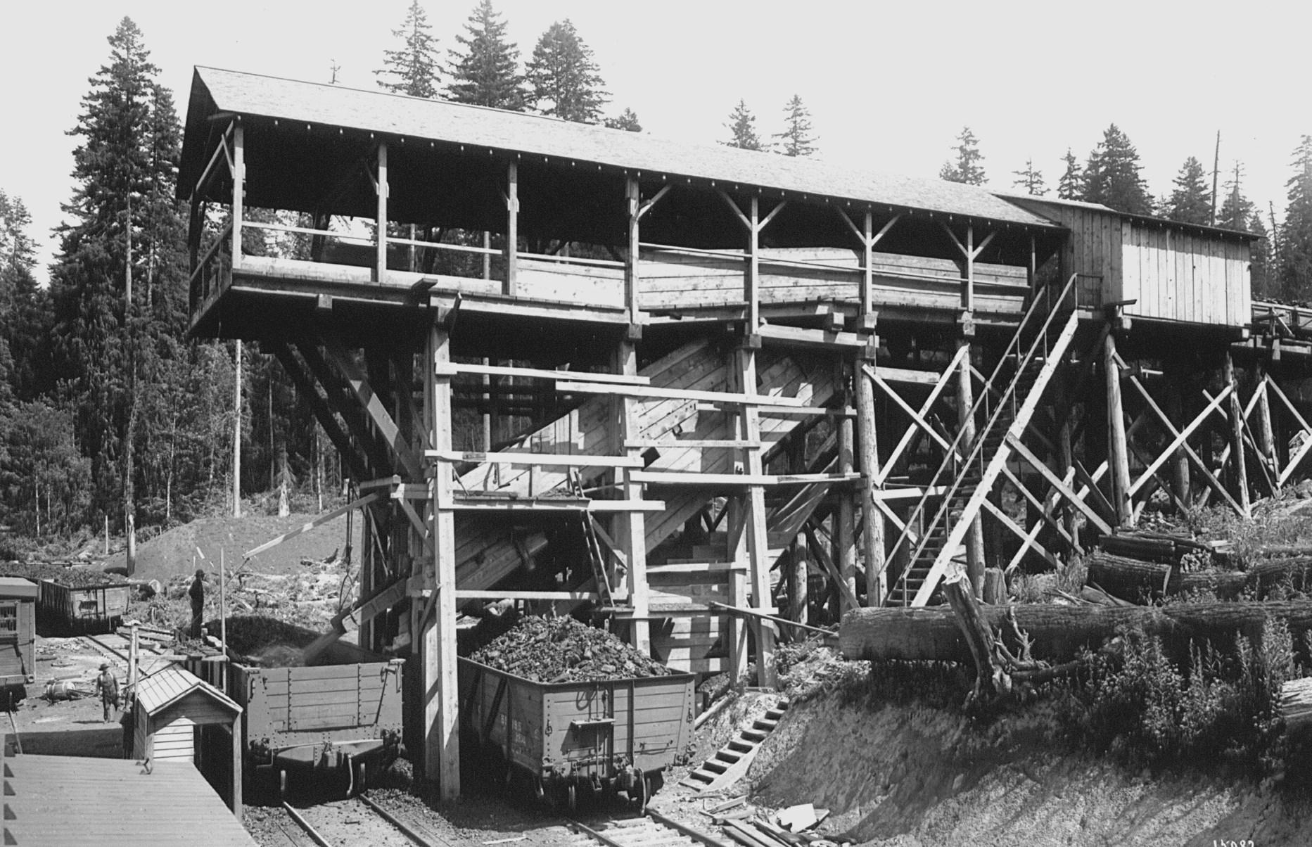
The Pacific Coal & Gas Company began removing coal from its mine by September of 1910. It is unclear when this location became known as the Skookumchuck Mine. The mine entrance was on the southwest side of the Skookumchuck River, in the northwest quarter of the northwest quarter of Section 8, Township 15 North, Range 1 West. In 1911, the
company built a railroad, 9,600 feet in length, from the Northern Pacific mainline to its coal bunker; the bunker was located on the northeast side of the river, opposite the mine entrance. Figure 13 outlines the course of this track. The Pacific Coal & Gas Company was out of business by 1916, as was its short railroad. Figure 8 suggests that in 1927, the Quality Coal Mine was located on the same vein of coal, approximately 0.25 miles
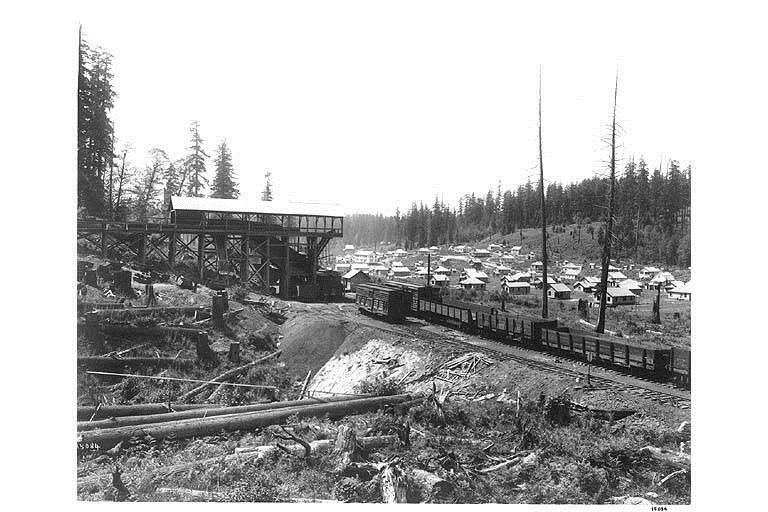
southeast of the opening for the Skookumchuck Mine. In a 2001 interview, Lyle Schultz reported that during his lifetime, an open-pit coal mine was in use at the site of the old Skookumchuck Mine.
The Washington Union Coal Company, at Tono, was an auxiliary of the Union Pacific Railroad. In 1909, that railroad built a branch line to Tono. The coal company supplied fuel used by Union
Pacific locomotives in western Washington. In addition, a couple of logging railroads operated successively from the eastern end of the Tono Branch, and a moderate-sized community grew up around the mine at Tono. Figure 14 provides a detailed look at the structures in place at Tono. Figure 15 is a view east, toward the company’s coal-loading tipple. The Town of Tono, as well as the tipple, can be seen in the view to the northwest reproduced in Figure 16. Figure 17 is a 2010 photograph of the same area, taken by the

author, from Tono Road. The extensive system of coal galleries at Tono are evident in Figure 18. The use of coal by the Union Pacific Railroad gradually diminished as the railroad began the conversion to diesel engines. Its branch to Tono was removed in 1957.

For several reasons the number of houses at Tono diminished over the years. Automobile use meant that workers no longer had to live in town. Some of the residences were moved to other locations. By the 1970s, only the former superintendent’s home remained occupied.9
Toward the end of the Tono mine’s operating life, underground removal of coal at the mine ceased, and further production was accomplished by strip mining. That activity destroyed most traces of the town’s existence.
Twenty-first Century concerns about the environment make it unlikely that there will be a resurgence in the use of coal, even though large reserves of that material are still in the ground locally. But the imprint of that industry on the land can still occasionally be seen.
1 Henry Landes, Washington Geological Survey, Volume II, Annual Report for 1902. Tacoma: Pioneer Bindery and Printing Company, 1903, page 238.
2 Landes, page 239.
3 Guley versus Northwestern Coal & Transportation Company. 7 Wash. 491, No. 978. Washington Supreme Court. Decided December 28, 1893.
4 Stephen H. Green, Report of Investigations No. 4 Coal and Coal Mining in Washington. Division of Mines and Mining. Olympia: State Printing Plant, 1943.
5 Landes, page 239.
6 Harold E. Culver, The Coal Fields of Southwest Washington Bulletin No. 19. Olympia: Washington Geological Survey, Frank M. Lamborn, Public Printer, 1919, page 82.
7 Culver, page 82.
8 Culver, page 83.
9 Emmett O’Connell, “Tono Ghost Town with a Ghost Landscape.” http://www.thurstontalk.com/ 2013/10/29/tono-ghost-town-ghostlandscape/ (accessed July 5, 2017).
Public Health Service. Railroad history has been a life-long interest, and he has written several books on the subject.
Dr. Hannum is a retired physician and surgeon who spent his early years in Michigan. He arrived in western Washington in 1971 as a member of the U.S.
This piece of equipment is roughly five feet high and three feet wide. It consists of a heavy cast iron framework with numerous gauges, valves and spigots connected by rubber tubing. But what is it? Turn to the inside back cover for the answer.

Thanks to the Olympia Tumwater Foundation for this issue’s “What Is It?” feature.
The Olympia Tumwater Foundation owns and operates Tumwater Falls Park, and the historic Schmidt House, home of the Leopold and Johanna Schmidt family, founders of the Olympia Brewing Company. Tumwater Falls Park is open daily and offers picnic areas, hiking trails, and views of the spectacular Deschutes River canyon. The Schmidt House is open one day a month for guided tours, and is also available for rent as an event venue. The landscaped grounds include the Centennial Rose Garden, maintained by the Olympia Rose Society.
www.olytumfoundation.org
This bottle filling machine was used by the Olympia Brewing Company at its plant in Tumwater, or at one of its bottling plants elsewhere in the Northwest. The machine, manufactured by the Cleveland Faucet Company, was used sometime between 1896 and late 1915 (when Washington State adopted Prohibition).
Kegged beer was often shipped from the brewery to bottling plants in distant cities, where the kegs were tapped and used to fill individual bottles for wholesale or retail. A filling machine like this made the process much smoother. Several of these machines would have been lined up and operated by one man, who needed a deft hand and a sharp eye to slip empty bottles onto each spigot, lock the bottles into place, watch the bottles fill up from the bottom, then remove the filled bottles, and start the whole process over again.
The bottle filling machine is in the collection of the Schmidt House, built in 1904 for the Leopold and Johanna Schmidt family.

Image from the April 1899 issue of American Brewers’ Review.
