Number 17 April 2022
 Tumwater Falls and the Yellowstone Hotspot: A Geologic History of Thurston County, Washington $5.00

Number 17 April 2022
Tumwater Falls and the Yellowstone Hotspot: A Geologic History of Thurston County, Washington $5.00
The Thurston County Historical Journal is dedicated to recording and celebrating the history of Thurston County.
The Journal is published by the Olympia Tumwater Foundation as a joint enterprise with the following entities: City of Lacey, City of Olympia, Confederated Tribes of the Chehalis Reservation, Daughters of the American Revolution, Daughters of the Pioneers of Washington/Olympia Chapter, Lacey Historical Society, Old Brewhouse Foundation, Olympia Historical Society and Bigelow House Museum, South Sound Maritime Heritage Association, South Thurston County Historical Society, Thurston County, Tumwater Historical Association, Yelm Prairie Historical Society, and individual donors.
Publisher
Olympia Tumwater Foundation
John Freedman, Executive Director
Lee Wojnar, President, Board of Trustees
110 Deschutes Parkway SW P.O. Box 4098 Tumwater, Washington 98501
360-943-2550
www.olytumfoundation.org
Editor
Karen L. Johnson 360-890-2299
karen@olytumfoundation.org
Editorial Committee
Drew W. Crooks Jennifer Crooks
James S. Hannum Erin Quinn Valcho
The Journal does not offer a subscription service. To get your own copy, join one of the heritage groups listed at the top of this page. These groups donate to the publication of the Journal, and thus receive copies to pass on to their members. Issues are also available for purchase at the Bigelow House Museum, Crosby House Museum, and Lacey Museum, and occasionally at Orca Books in downtown Olympia and Hedden’s Pharmacy in Tenino.
One year after print publication, digital copies are available at www.ci.lacey.wa.us/TCHJ.
The Journal welcomes factual articles dealing with any aspect of Thurston County history. Please contact the editor before submitting an article to determine its suitability for publication. Articles on previously unexplored topics, new interpretations of well-known topics, and personal recollections are preferred. Articles may range in length from 100 words to 10,000 words, and should include source notes and suggested illustrations.
Submitted articles will be reviewed by the editorial committee and, if chosen for publication, will be fact-checked and may be edited for length and content. The Journal regrets that authors cannot be monetarily compensated, but they will gain the gratitude of readers and the historical community for their contributions to and appreciation of local history.
Opinions expressed by contributors are not necessarily those of the Olympia Tumwater Foundation.
Written permission is required to reproduce any part of this publication.
Copyright © 2022 by the Olympia Tumwater Foundation. All rights reserved.
ISSN 2474-8048
Number 17
April 2022
3 Tumwater Falls and the Yellowstone Hotspot: A Geologic History of Thurston County, Washington Gary A. Ritchie, Ph.D.
Back Cover
Who/What/Where Is It?
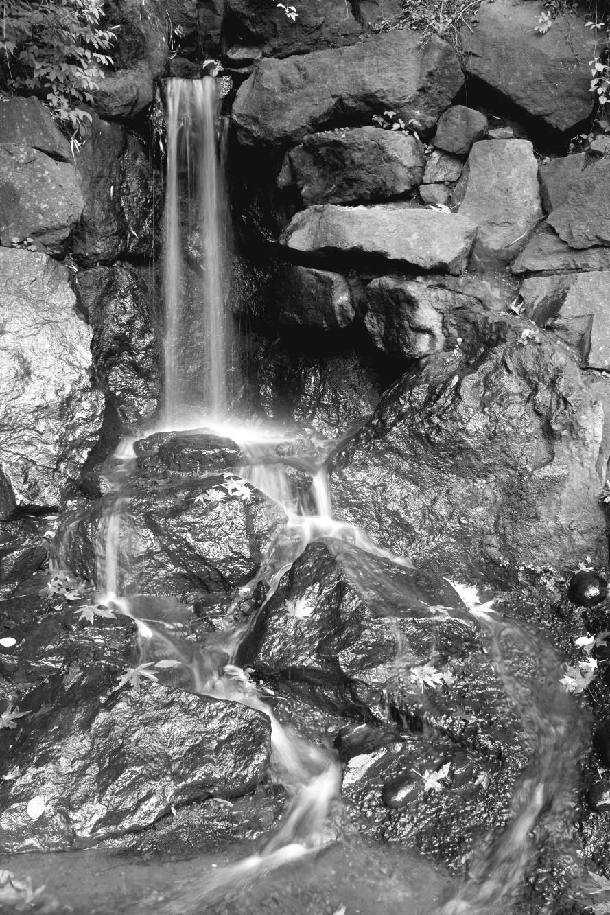
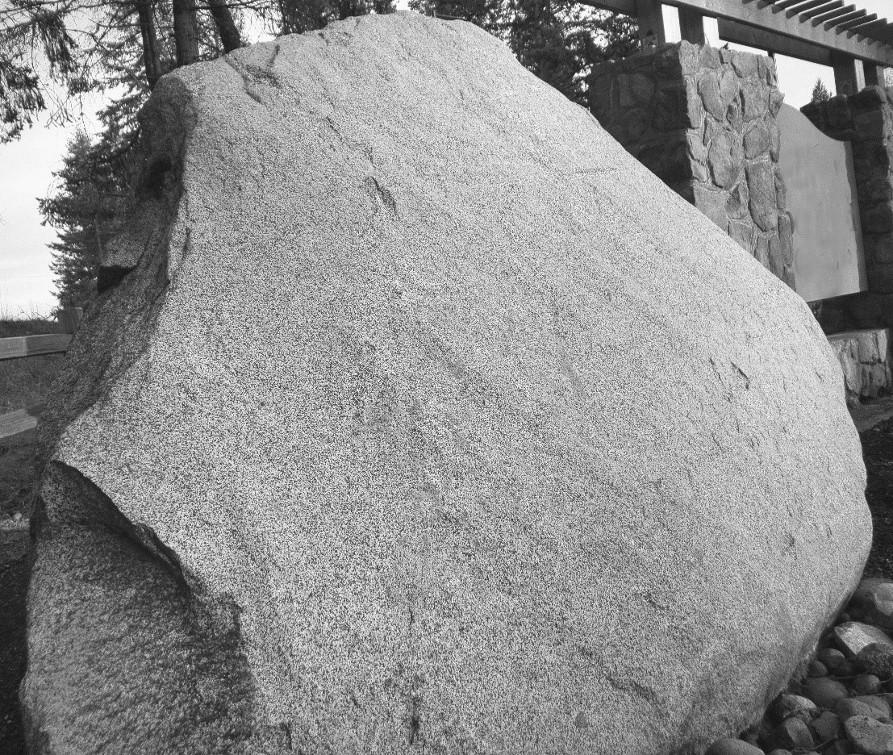
On the cover: The Deschutes River cascades over a cliff of Crescent Basalt in Brewery Park, forming Lower Tumwater Falls. Note the basalt columns to the immediate right of the falls. Photograph courtesy of Gary Ritchie.
See related article on page 3.

The wonder of Yellowstone pervades our national identity. Show me an American who has not heard of Old Faithful, or seen movies of Yellowstone bison in winter snorting great clouds of steam into the frigid Wyoming air. Who among us was not deeply saddened to learn that 800,000 acres of primeval Yellowstone forests went up in smoke in the terrible fires of 1988? Many Americans worry about the volcanic Yellowstone Hotspot, having read that it could erupt again someday and obliterate most of North America.
But let’s face it to link the Yellowstone Hotspot to Tumwater Falls is a stretch. How could there possibly be a connection when Yellowstone is in
Wyoming, 800 miles away, while Tumwater Falls is right here in Thurston County? Good question.
Here’s the story.
The best available science tells us that Earth is about 4.543 billion years old, plus or minus 50 million years.2 This estimate is based on radiometric analysis (Sidebar 1) of the oldest known rocks on Earth and on the moon, which is believed to be roughly the same age as Earth.
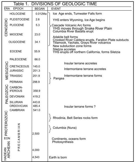
Opposite: Table 1. Geologic time scale summarizing events described in this article.1 “Ma” stands for millions of years ago; thus the events at the bottom of the scale are the oldest. “YHS” stands for Yellowstone Hotspot.
Our knowledge of Earth’s history during the first 2.5 billion years is sketchy at best. It is believed that during the 4.543-4.000-billion-year Hadean Eon (named for Hades, the Greek God of the Underworld), Earth’s surface was a living hell punctuated by volcanic eruptions spewing out molten lava, and penetrated by countless asteroid impacts. Earth and its core were formed, and the moon was born, during the Hadean.
Throughout this article I have reported the ages of various rocks and formations in millions of years, sometimes to two decimal places. But how do we know this? How can we determine the age of a rock?
Modern methods of rock dating are based on the rate of natural radioactive decay of certain unstable isotopes of elements contained within the rocks. On the date a rock, like granite, forms in the magma chamber of a volcano, these unstable isotypes (parents) begin to decay into stable isotopes (daughters). Over time, the ratio of parent to daughter gets smaller as decay progresses.
For each isotope, the rate of decay is assumed constant and has been precisely measured and confirmed by laboratories worldwide for many decades. This rate of decay is often conveniently expressed as a half-life: the time required for half of an unstable parent to decay to the stable daughter.
Some isotopes useful in rock dating are:
uranium-238 decays to lead-206 (4.5-billion-year half-life)
uranium-235 decays to lead-207 (704-million-year half-life)
potassium-40 decays to argon-40 (1.25-billion-year half-life)
Potassium-argon (K/Ar) dating is the oldest and most useful technique, but not necessarily the most precise.
Here is how the process works using granite as an example. Granite is generally made up of three minerals: quartz, feldspar, and biotite. A granite sample is ground up and biotite crystals are collected and chemically analyzed. Biotite contains five elements: silicon, oxygen, aluminum, potassium, and argon. The potassium (K-40) is radioactive and decays to argon (Ar-40). So, the concentrations of these isotopes are determined. When the rock was formed, only potassium was present, and there was no argon. If the potassium/argon ratio is measured to be 50:50, half of the potassium has decayed to argon. Since the half-life of potassium is 1.25 billion years, the granite rock is 1.25 billion years old.
Radiometric dating is ideally suited to dating igneous rocks, and to some extent metamorphic rocks. But it doesn’t work with sedimentary rocks, which are made up of particles of other rocks that may have widely different ages. Such rocks are often dated by dating volcanic rocks that lie above and below them, which sets the upper and lower limits to their age.
In the much longer Archean Eon (4.02.5 billion years ago), Earth’s crust cooled and solidified, continental plates and oceans formed, and tectonic activity began. Notably, this was also the time when the first prokaryotic (bacteria-like) organisms appeared in the oceans. Somewhere around 3.02.5 billion years ago, these singlecelled organisms invented photosynthesis. This miraculous series of photo- and bio-chemical reactions captured carbon dioxide and water and converted them into sugar using light energy, while liberating oxygen into the atmosphere. After about 2.5 billion years ago, atmospheric oxygen levels began to rise slowly causing a spike called the “Great Oxidation Event.” Photosynthesis would ultimately provide enough atmospheric oxygen to enable the development of all life forms on this planet.
As the primal continental blocks gradually formed, they began to coalesce into what are today known as supercontinents huge land masses that form when six or seven continental blocks drift together and fuse to become one.
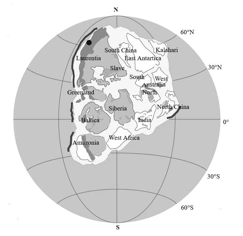
The first of these was discovered in 2002.3 It was named Columbia (also
known as Nuna), and may have formed some 2.5 billion years ago (Table 2, Figure 1). At the upper left of Figure 1 is a continental block called Laurentia. After eons of drifting, twisting and wrenching, Laurentia would ultimately become the North American and Eurasian continents.
The discovery of Columbia followed on the heels of the discovery of two more recent supercontinents: Rodinia and Pangea. This reflects the geologic principle that the older something is, the less evidence remains of its existence, therefore less can ever be learned about it.
Columbia seems to have persisted until about 1,500 Ma (million years ago used throughout this article), at which time it began to break up, with each continental block drifting away on the backs of the great, ancient tectonic plates that existed during Columbia time.
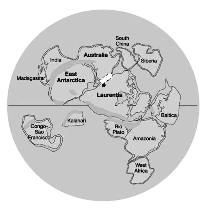
Rodinia formed about 1,100 Ma (Figure 2), perpetuating the cycle of supercontinent building and rifting (splitting apart). During the time Rodinia existed, Laurentia was believed to have been linked to Australia.4 Evidence for this link comes from
Table 2. Three supercontinents, estimated dates of formation, break-up, life span, and discovery. *Ma = million years ago.
Top: Figure 1. Presumptive map of supercontinent Columbia. Heavy black lines presumptive subduction zones; dark gray mountain ranges; medium gray cratons older than 2-3 million years; black dot approximate location of Spokane, Washington. Laurentia contained what would become North America. Sources: references listed in endnote 3; graph modified from Wikimedia Commons.
Bottom: Figure 2. Presumptive map of supercontinent Rodinia. To be considered a supercontinent, about 75% of the continental blocks need to be fused together. Nearly all of future North America was contained within Laurentia. The white area marks the approximate location of Belt Series rocks. The black dot marks the approximate location of Spokane, Washington. Modified from Wikimedia Commons.
Opposite: Figure 3. Drawing of the supercontinent Pangea before breakup showing outlines of modern continental blocks. The black dot is the approximate location of Spokane, Washington. Source: Shutterstock, purchased and modified.
a band of 1.1-billion-year-old rocks known as the Belt Series. These bedded sandstones, limestones, and shale rocks, which are four to ten miles thick and 77,000 square miles in area, were formed from fine-grained sediments that eroded from both Australia and North America while they were linked. The sandstones have since metamorphosed into quartzite. Therefore, Australia contains quartzite from northwestern North America and vice versa. This ancient quartzite, among the oldest rocks in Washington State, can be observed close-up at Steptoe Butte State Park south of Spokane.
The most recent participant in the parade of ancient supercontinents was called Pangea, which formed about 300 Ma (Figure 3). Pangea was named in 1912 by famed German meteorologist and geophysicist Alfred Wegener,
for the Greek word pangaia meaning “all the Earth.” For some 100 million years Pangea sprawled astride the equator like a monstrous, beanshaped jigsaw puzzle completely surrounded by ocean.
During Pangea time, the outlines of our seven modern continents became recognizable. The western sea, called the Panthalassa Ocean or “The Mother of All Oceans,” would ultimately give birth to the Pacific. To the east, across the narrow mid-section of Pangea, lay the Tethys Sea, named for one of the Greek Titan goddesses. The 250million-year-old fossiliferous limestone that provides evidence of Pangea’s existence can be found today in the mountain ranges of Turkey, Iran, Afghanistan, Tibet, and China.

Roughly 200 Ma, at the dawn of the Jurassic Period, the massive supercontinent of Pangea began coming apart.5 For the next 166 million years, as the dinosaurs came and went or evolved into birds, and as mammals and land plants burgeoned and diversified to populate the far reaches of the planet, the North American and Eurasian continents plowed inexorably north across the Panthalassa Ocean at a rate of about one inch per year, ultimately to form the northern hemisphere. Similarly, the southern hemisphere began to take shape as South America, Africa, Antarctica, and Australia broke apart and drifted southward into the broad, enlarging Tethys Sea.
Wegener had hypothesized that such an event must have occurred owing to the uncannily precise correspondence of the coast lines of the Americas with those of Africa and Europe, as well as a perfect match of certain fossils and rock types on both sides of the Atlantic. But in his day, Wegener was considered a crank; after all, what titanic force could he possibly conjure up that would be capable of ripping apart great continents? Another 75 years would pass before Wegener’s theory of “continental drift” was accepted as settled science. Sadly, Wegener did not live to see his work acclaimed, having lost his life at age 50 in a Greenland blizzard in November 1930, while searching for evidence with which to test his hypothesis.
About 200 Ma, during the early Jurassic, the outline of the North American continent was roughly similar to the way it appears today. Along the east coast lay the Appalachians, an ancient mountain range that had begun forming about 480 Ma as the first blocks of Pangea began to assemble. In their heyday, before rivers, glaciers, and other erosive forces reduced them to a range of low hills, the Appalachians are believed to have resembled the Rockies in their height and grandeur.
To the west, a vast mid-continental plain surrendered to a narrow, northsouth trending coastal range of low mountains. These lands comprised what is now known as the North American craton6 the immense, an-
cient basement of the North American continent. This layer cake of rock, loosely described as limestone, sandstone, and shale overlaying ancient metamorphic rocks, has a maximum thickness approaching 155 miles.
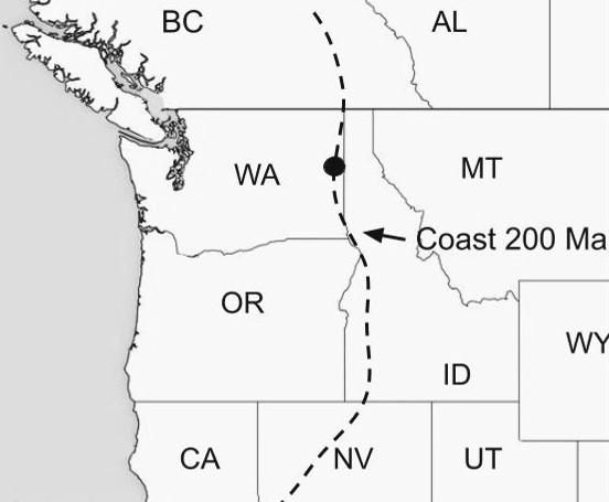
However, during this point in Earth history something important was strikingly absent from the North American craton. The entire modern west coast, from Alaska to southern California, was missing! Ocean beaches lay roughly where the Washington/ Idaho border lies today (Figure 4). Had you lived in Spokane 200 Ma, your view west would have been across the vast, shimmering Panthalassa Ocean to a distant horizon where sky met water.
The North American craton lies east of the dashed line. The black dot marks the location of present-day Spokane. Source: public domain, adapted by the author.
During the formation and breakup of the three supercontinents, Columbia, Rodinia, and Pangea, nothing lay west of Spokane except salt water. So, what has happened? What titanic events could have occurred during the past 200 million years to assemble the entire west coast of North America?
To address this question, we need first to consider that the North American continent, like all the continents and ocean bottoms of the world, is riding on a massive tectonic plate.7 The oceanic plates, consisting mostly of dense basaltic rock (Sidebar 2), are much heavier than the continental plates, which contain mainly less dense granitic rocks. Because of this difference in density, when a continental plate collides with an oceanic plate, the oceanic plate almost always slides beneath the lighter continental plate and dives down into the aesthenosphere, the upper zone of Earth’s mantle. This process is called subduction and it has been happening all around the world for perhaps 3.5 billion years. During the Jurassic Period, the oceanic plate that was subducting beneath the North American Plate was called the Farallon Plate.8
Now, imagine that large numbers of islands were riding on the Farallon Plate mainly volcanic island arcs like Hawaii and the Galapagos, and gigantic flat-topped masses of oceanic basalt known as Large Igneous Provinces, such as Iceland. Many of these islands were surrounded by coral reefs that ultimately formed limestone plateaus, which themselves were surrounded by
layers of thick sediments that had eroded from the islands. Undersea landslides involving these sediments formed strange rocks called turbidites, which gradually became sandstones many containing marine fossils. These islands often joined at sea, as oceanocean plates collided to form complex super islands made of all sorts of rock igneous, sedimentary, and even metamorphic. Some of these super islands were hundreds of miles long.
When an oceanic plate subducts beneath a continental plate, the islands that are riding the oceanic plate into the coast are scraped off the plate and become accreted (adhered) to the continent a process called docking. These accreted parcels of real estate are known as exotic terranes.9 Groups of islands that fused together before docking are called superterranes.
A helpful way to visualize this process is to place yourself in the checkout line at the grocery store. Groceries purchased by the customer in front of you are sitting on the metal platform in front of the cashier. You then load your groceries onto the conveyor belt.
Suddenly, the conveyor belt turns on and jolts forward, carrying your groceries into those of the customer in front of you. Your stuff piles up into her stuff, boxes fall down on vegetables, paper goods get squeezed against pieces of meat, tomatoes are squashed by six-packs of soda. The result is a hodgepodge of totally unrelated objects piled up against, on top of, and beneath each other.
Basalt (pronounced bə ΄ sôlt) is the most common rock type in Earth’s crust, comprising some 90% of all of the various igneous rock types, mostly on ocean bottoms. The table below shows how basalt fits in with other igneous rocks.
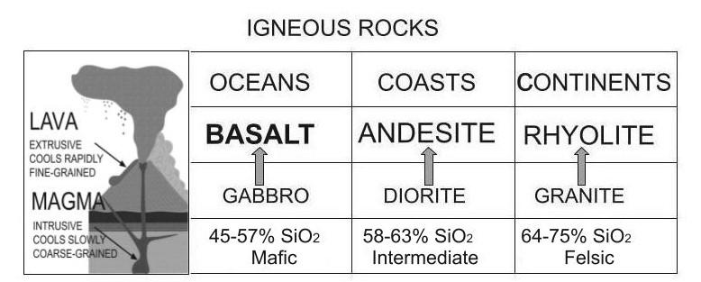
Igneous rocks are classified as either intrusive or extrusive. Intrusive rocks (gabbro, diorite, granite) are intruded up into Earth’s crust from the mantle to form huge chambers of magma, or molten rock. When this rock exits the chamber through a volcano or fissure, it becomes an extrusive rock or lava. So, basalt is an extrusive rock that derives from the intrusive rock called gabbro. Different intrusive magmas form different types of lavas (e.g., diorite forms andesite).
Where a rock fits into this table depends largely on how much silica (in the form of SiO2, silicone dioxide) it contains. Low-silica lavas are called mafic, while high-silica lavas are called felsic. Mafic lavas are dark, high in iron and magnesium, and flow readily. In contrast, felsic lavas are light, high in silica, and flow very slowly. The chemical composition of lava rocks holds important clues as to how and where they formed as well as to their age (see Sidebar 1). Shield volcanoes, like those on the Hawaiian Islands, are formed from mafic ocean-bottom basalt, while explosive volcanoes like Mount Rainier and Mount St. Helens eject felsic lavas.
When basalt lava is extruded underwater, it forms what is known as “pillow” lava owing to the pillow-like appearance of the extruded rocks. Sometimes basalt that erupts above ground forms tall, magnificent columns as can be seen in abundance in the cliffs of the Columbia River Basalt Plateau, and in the Black Lake Resources quarry in Tumwater (see Figure 18).
The grocer’s platform and the groceries it contains are analogous to the continental margin. The conveyor belt is the oceanic plate, and your groceries are the islands riding the plate. You get the picture.
This analogy, as illustrative as it is, leaves out two important points. First, in the real world both plates are moving toward each other. Second, as described above, many of these terranes had collided on the oceanic plate to form superterranes, which were scraped off the oceanic crust and thrust upon the land.
The process of docking is illustrated in Figure 5. Here the thin, dense, basaltic oceanic plate is colliding with a thick, less dense, continental plate
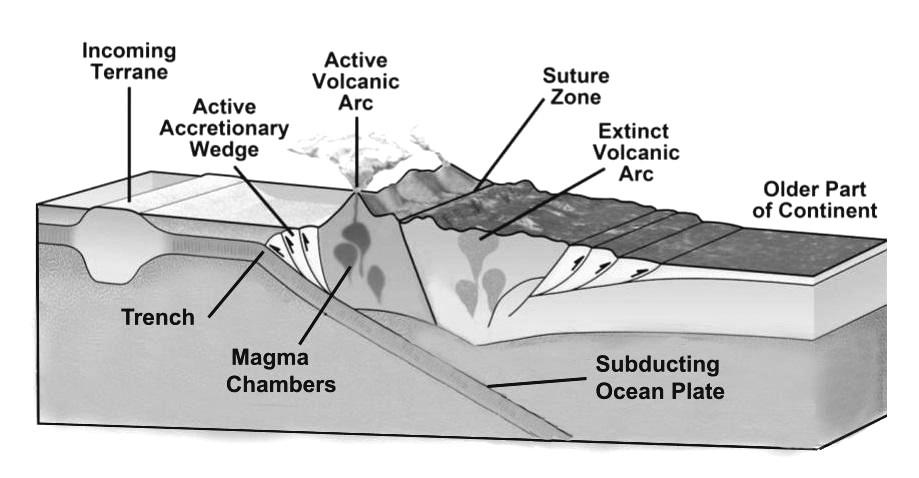
and then diving down into the mantle. At the point where the water-soaked oceanic plate is grinding up against the dry continental plate, vast amounts of heat are generated that form great blobs of molten rock called magma chambers. From these chambers, fingers of magma work their way up through the existing bedrock, forming imposing and dangerous volcanoes like Mt. Rainier and Mt. St. Helens. A dozen or so such volcanoes now form a line, a volcanic arc, running parallel to the coast roughly 150 miles inland all the way from Alaska down into northern California.
Beginning about 170 Ma, these great armadas of assembled rock began piling up at sea and plowing across the ocean on the Farallon Plate before ac-
Top: Figure 6. Map of North America showing approximate locations and extent of major exotic terranes. Source: modified from Wikimedia Commons.
Bottom: Table 3. Summary of superterranes and terranes that have accreted to the North American continent, their current location, date of formation, date of docking, rock type, and origin. This is an incomplete list; many smaller, yet significant, terranes are scattered throughout western North America. LIP Large
creting to the west coast of North America (Figure 6, Table 3).
Eroded sediments from the western flanks of the volcanoes, along with sediments worn away from incoming islands, migrate downward into the trench that exists at the point of subduction. These are pushed upward by the ocean crust into what are known as accretionary wedges. These wedges may also be scraped up onto the shore and added to the accreted terranes, further complicating an already incomprehensible landscape. Often, extinct volcanic arcs can be found to the east of the current arc relicts of volcanos that have erupted and died over past millennia. The sites of these extinct volcanos can be located by the granitic remains of their magma chambers. These are called plutons and the Cascades are full of them the Goat Rocks, for example.10
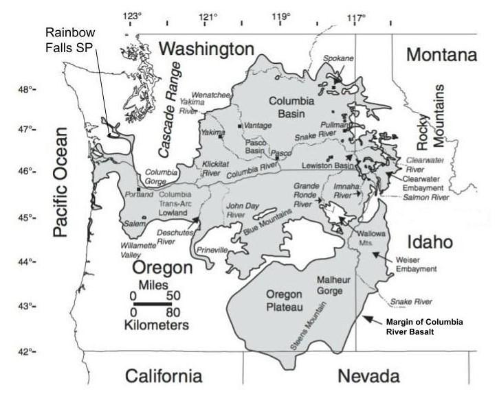
Where can you observe these terranes? Unfortunately, there are relatively few places in Washington or Oregon where they are exposed at the surface. This is because the vast Columbia River Basalt plateau (Figure 7), which erupted 16-15 Ma, covers much of eastern Washington and Oregon, burying whatever terranes lay beneath it under about three miles of lava. A tongue of the basalt plateau extends all the way to the Chehalis River where it forms the bedrock beneath Rainbow Falls State Park. With an estimated area of about 62,000 square miles, the Columbia River Basalt plateau is the third largest basalt plateau
in the world.11 Glacial till and volcanic ejecta have hidden nearly all of the terranes in the Puget Lowland, while marine sedimentary rocks forced inland and upward have covered much of the Olympic Peninsula.
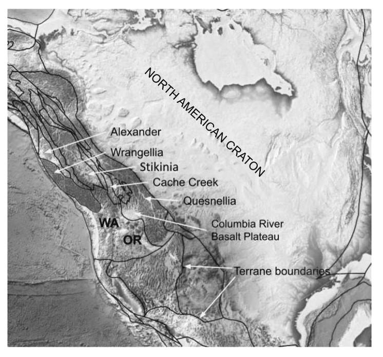
The few remaining locales where terranes can be observed at the surface are in the Okanogan Highlands (Quesnellia), North Cascades (Intermontane), and the San Juan Islands (Insular). They are also accessible in the Blue Mountains in northeast Oregon (Quesnellia) and the Klamath Mountains in southwestern Oregon (Stikinia).
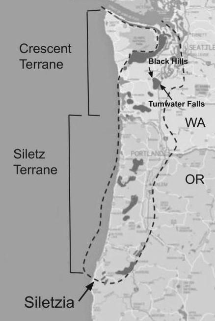
Unlike the terranes described above, which docked during the Mesozoic Era, the gigantic superterrane known as Siletzia is a relative newcomer.12 It was formed at sea during the Paleocene-Eocene transition, 56-49 Ma, and accreted to the northwest coast 51-49 Ma.Siletzia can hardly be called an exotic terrane, however, having been born just off the coast of northern California.
A mostly basalt 800-pound gorilla, Siletzia forms the basement rock all the way from southern Vancouver Island to southern Oregon and east to the Cascade Mountains (Figure 8). On southern Vancouver Island it is called the Metchosin Terrane. In Washington it is the Crescent Terrane, and in Oregon the Siletz Terrane.13 With a foot-
print of about 400 miles by 200 miles, and averaging ten to twelve miles thick, Siletzia is estimated to hold ten to twelve times the volume of basalt (480,000 cubic miles) as the Columbia River Basalt plateau. And as if that’s not enough, it is believed that during the formation of Siletzia, fully half of it broke off and rode the Kula Plate north across the Pacific, where it docked along the coast of Alaska from
Anchorage to Yakutat, and is now known as the Yakutat Terrane.
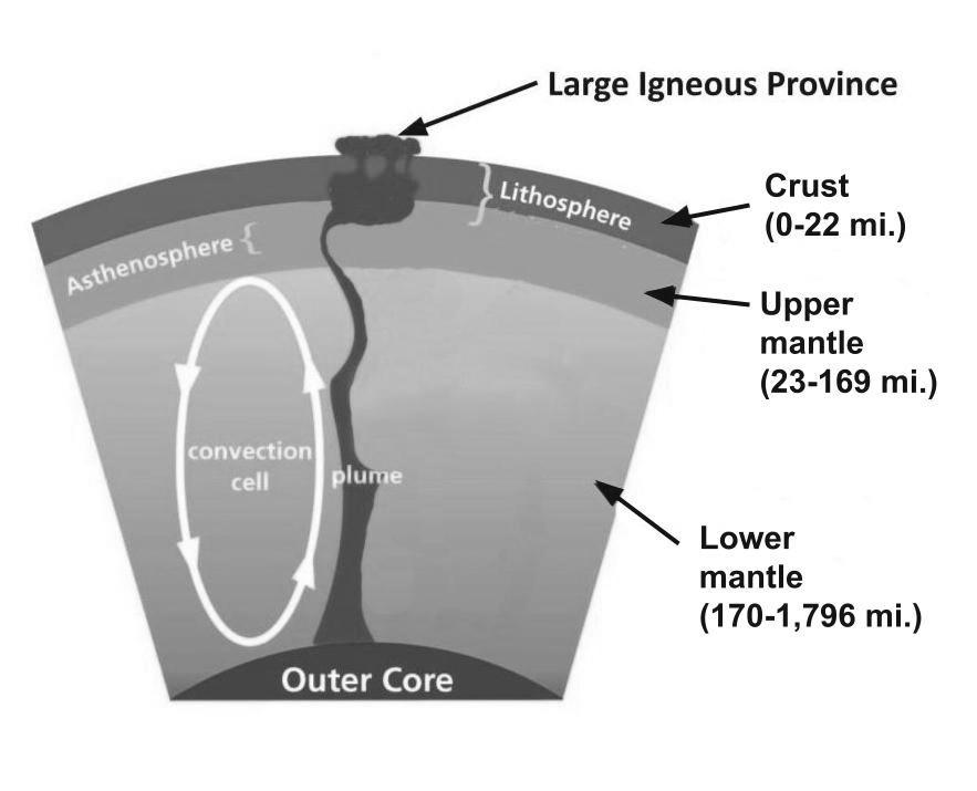
Many geologists believe that Siletzia originated as a large igneous province formed from a mantle plume about 150 miles offshore of the OregonCalifornia border. Mantle plumes are mysterious but relatively common occurrences (Figure 9). Originating at the boundary between the core and
lower mantle, they develop above a long tail that exits the core/ mantle boundary and grows upward culminating in a great undersea magma chamber. Streams of magma burn their way up through the thin oceanic crust forming oceanic plateaus or large igneous provinces.
In the case of Siletzia, the lava apparently continued to erupt for at least four million years, building a massive plateau whose height eventually exceeded sea level to form an immense island of basalt. This is evidenced by the
Top: Figure 8. The superterrane
Siletzia is comprised of two terranes known as the Crescent Terrane in Washington and the Siletz Terrane in Oregon. The dashed line is the approximate known extent of Siletzia, while the dark gray areas mark places where it is visible at the surface. Tumwater Falls and the Black Hills are indicated. Source: reconstructed from references in endnote 13.
Bottom: Figure 9. Drawing of a mantle plume giving rise to a Large Igneous Province. The plume of molten mantle rock rises through the mantle and breaks into the crust. It then creates fissures in the crust through which fingers of basalt surge upward to form a large igneous province. Source: U.S. National Park Service image, adapted by the author.
fact that lower portions of Siletzia basalt contain huge masses of pillow lava, while the upper parts are mainly columnar (see Sidebar 2). So, from about 56-49 Ma, Siletzia was accreting to the coast while it was still erupting.
The collision of Siletzia with the Pacific Northwest coast has been described as a slow-motion train wreck, impacting mountains, rivers, faults, and tectonic plates over a wide area for literally millions of years. It is hard to overstate the magnitude of the effects this collision had on the northwestern landscape. Some examples include:
Chuckanut/Swauk folding. The fossilbearing sandstones and shales of the Chuckanut Formation just south of Bellingham and its contemporary sister, the Swauk formation, at the summit of Blewett Pass,
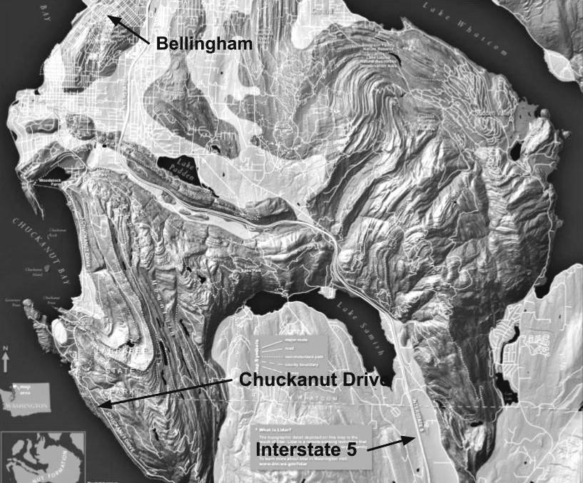
were laid down around 54–34 Ma in a vast coastal plain. After Siletzia docked, it pushed north and west causing massive folding of these formations (Figure 10).
River reversals. Detailed studies of the eastern Washington Swauk Formation show distinct differences between the sands laid down before and after 51 Ma. Those laid down before 51 Ma were carried by rivers flowing toward the west, while those laid down after 51 Ma were western rivers that were now flowing toward the east. This is interpreted as reflecting the compressional lifting of Washington’s coastal region by Siletzia causing the western rivers to switch direction and flow downhill to the east.14
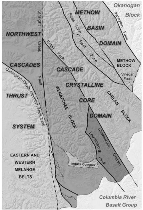
Strike-slip faulting. Strike-slip faults occur when two blocks of Earth slide horizontally past one another, such as in the San Andreas Fault in California. Beginning about 50 Ma and later, large numbers of northwest-trending strike-slip faults occurred in northwestern and central Washington
(Figure 11). The most notable example of these is the 200-mile-long Straight Creek Fault, which was active from 50-35 Ma. It runs from British Columbia down through the North Cascades and terminates slightly east of Snoqualmie Pass. Total movement along this fault during this time was about 90 miles. The timing and directionality of these faults strongly suggests they result from the immense pressure exerted by Siletzia as it surged northeastward into the continent.
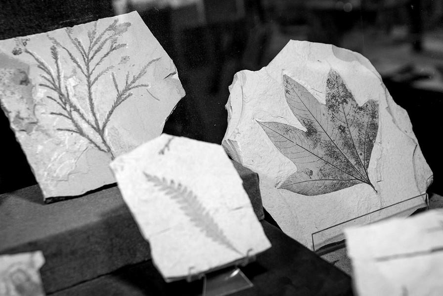
Formation of grabens and strike-slip basins. When the land surface spreads apart causing deep parallel faults to form, the block of land between faults drops down to create a narrow valley called a graben. Many grabens exist in northern Washington including the Methow, Toroda Creek, and Republic Grabens. The Republic Graben is home to the famous Stonerose Fossil Site, where visitors rent rock hammers and chisels and chip away looking for Eocene plant, insect, and fish fossils (Figure 12). These fossils formed about 49 Ma as the graben filled with sediments from surrounding streams and rivers that flowed into the valley.15 The twisting and fracturing of the land surface in response to the impact of Siletzia is responsible for the formation of many of these grabens. A similar geologic feature known as a strike-slip basin exists between Leavenworth and Wenatchee.
Blockage of subduction zone. For about ten million years, following the accretion of Siletzia, the Farallon Plate
stopped subducting beneath the North American Plate. While this was happening, seismic evidence suggests that the portion of the plate that had already slipped beneath the continent broke off and began free-falling down through the mantle. When subduction resumed, about 44 Ma, the formation of the Cascade Volcanic Arc (Cascade Mountains) began (formation of the Cascades will be discussed later).
The major rock types of the North Cascade Range, its “crystalline core,” are ancient metamorphic rocks that metamorphosed at least twenty miles beneath the surface under heat and great pressure. When Siletzia accreted, these beautiful metamorphic rocks were pushed to the surface to form the North Cascades by still poorly understood tectonic forces (Figure 13).
Climate change. The so-called Paleocene-Eocene Thermal Maximum (PETM) was a 170,000-year period when the climate of planet Earth warmed more than 9°F. The PETM began about 56 Ma, during the eruption of Siletzia. This temperature increase is evidenced by the subtropical nature of many of the plant fossils exhumed at the Stonerose Fossil Site as well as the rocks of the contemporaneous Chuckanut and Swauk formations. Some scientists have proposed that the temperature increase was caused by a huge methane discharge from marine gas hydrate reservoirs, which could have been released by a massive oceanic volcanic event such as the accretion of Siletzia.
Figure 12. A collection of Eocene fossils from the Stonerose Fossil Site in Republic, Washington. Left to right: sequoia, fern, sycamore. Source: Washington State Parks (https://www. parks.wa.gov/493/Curlew-Lake, accessed March 15, 2022).
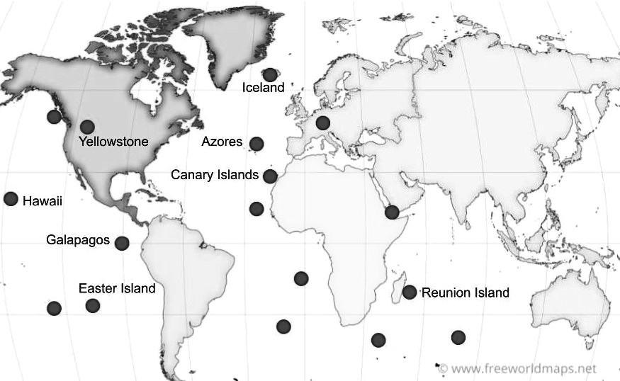
Mantle plumes, such as the one that built Siletzia, are relatively common around the world (Sidebar 3). More than twenty known mantle plumes include those that built the Hawaiian Islands, Galapagos Islands, Canary Islands, Reunion Island, Easter Island, the Azores, and Iceland. These are all comprised of basalt that originated at or near the core-mantle boundary.
Mantle plumes are also known as hotspots.
Considerable geochemical and chronological evidence now clearly indicates that Siletzia, including the beautiful black Crescent Basalt of Tumwater Falls (cover photo), was formed by the
Yellowstone Hotspot about 56 Ma. This evidence includes: (1) the geochemistry of Siletzia’s mafic lavas points to a mantle plume source; (2) temperature calculations are consistent with lava temperatures developed in hot mantle plumes; (3) proposed age, composition, and timing of accretion are confirmed by field observations; (4) modeling studies of ancient plate movements substantiate the location of a Yellowstone-like hotspot offshore of the Northwest during late Paleocene-early Eocene time; and (5) isotopic and trace element analyses show components of the Siletzia Basalt to be similar to Colum-
bia River Basalt lavas (the importance of this correlation will become apparent in the next section). Finally, the production of a large igneous province with a volume of 480,000 cubic miles is difficult to envisage without invoking a hotspot.
In sum, many geologists who have studied this subject believe it is nearly certain that the Yellowstone Hotspot was present in the Pacific off the coast of northern California in the time period 56-48 Ma. It is also clear that Siletzia was formed at the same location at the same time. Additionally, the chemical and physical composition

Nearly all volcanic activity on Earth occurs at the edges of plates, either plates spreading apart on the ocean bottom, or oceanic plates subducting beneath continental plates. However, some large volcanic eruptions also occur in the middles of plates. These are believed to be a result of mantle plumes.1
Also called hotspots, these enigmatic features of Earth’s mantle possess certain definitive properties: (1) they originate at the core-mantle boundary; (2) the plume has a long tail that extends down to the mantle-core boundary (see Figure 9); (3) as they rise, they cause the crust to bulge upwards and create huge basalt plateaus; (4) their location is fixed, so as they erupt, they create a chain of time-progressive volcanoes; and (5) their source is at least 400°F hotter than mid-ocean ridge basalt. While most geologists accept this in principle, others maintain that mantle plume theory is not needed because all volcanic activity can be explained by plate tectonics. They argue that volcanic activity can also occur in the middle of plates that are being stretched and cracked. As with most geologic debates, the jury is still out on this.
1 N. H. Sleep, “Mantle plumes from top to bottom,” Earth-Science Reviews, Volume 77, Issue 4, August 2006, pages 231–271.
Earth’s surface contains at least twenty mantle plumes (dark circles). Some of the more familiar ones are named here. Nearly all have oceanic locations. Source: www.freeworldmaps.com, modified by author.
of the Siletzia basalts is consistent with those of mantle plume-derived lavas and of those found associated with the modern Yellowstone Hotspot.16
This leaves us, then, with a very perplexing question: if the Yellowstone Hotspot created Siletzia 56 Ma, how did it end up in Wyoming today?
Try this. Turn on your cell phone flashlight and lay it on a table pointing upward. Then take a map of the Pacific Northwest, like the one in Figure 4, and hold it horizontally over the phone so the light shines up through the paper just offshore of northern California. Now, move the map very slowly west-southwest across the light. Can you see where this is going?
If the Yellowstone Hotspot is essentially stationary, which it is, and the North American Plate is moving westsouthwest, which it is, then the flashlight beam will cross southern Oregon and Idaho, and then finally light up northwestern Wyoming. This is what is believed to have happened. Geologists tell us that for at least the past 55 million years, the North American plate has been drifting west-southwest across the stationary Yellowstone Hotspot, causing its surface expression to be displaced to the northeast while leaving a trail of bedlam and destruction across southern Oregon and through the wide-open rangelands of Idaho’s East Snake River Plain to Yellowstone National Park (Figure 14).
But, unlike the flashlight beam, this track is anything but straight or unbroken. Why?
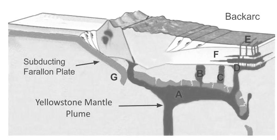
The main reason involves the complex interactions between the subducting Farallon Plate and the Yellowstone Hotspot. It turns out that subducted oceanic plates do not always sink into the mantle and disappear as had been previously believed and shown in Figure 5. Recent advances in a field called seismic tomography have provided geologists with the ability to produce three-dimensional images of objects within the mantle.17 From these images, we have learned that subducting plates can: (1) break up and fall downward relatively quickly into the mantle as slabs or curtains with gaps forming between and within them; or (2) move more or less horizontally beneath the crust for a considerable distance before diving down into the mantle (Figure 15). These slab behaviors can profoundly impact the path, configuration, timing, and chemistry of mantle plumes on their journey to the surface.
For example, in case (1) above, single magma streams could divide while moving upwards or sideways and then migrate through the gaps in the slab. Or, in case (2), buoyant magma could pool up beneath the slab, then flow sidewise, forward, or backward for long distances before migrating upward around the slab. Or magma could (3) melt directly through the slab carrying portions of melted slab with it, or (4) simply remain trapped beneath the slab, unable to rise to the
surface. In the process, magma could also cause crustal layers to delaminate and fall down into the slab. Any of these scenarios, or combinations thereof, might account for the strange jigs and jogs in the surface expression of the Yellowstone Hotspot as it migrated to the northeast.
With the above considerations in mind, the following scenario has re-
cently been proposed.18
Ironically, having been built by the Yellowstone Hotspot, the great basaltic plateau of Siletzia would then be penetrated from below by lava moving upward from the Hotspot as the North American plate containing Siletzia passed over it. Evidence for this is found in several 45-37 Ma lava eruptions along the Washington and Ore-
Figure 14. Yellowstone Hotspot track as it is being overridden by the North American continent. Numbers indicate ages in millions of years. AB adakite belt; B Bruneau-Jarbidge; CRB Columbia River Basalts; DS dike swarms; GR Gray’s River Volcanics; H Heise; M McDermitt; OC Oregon Calderas; P Picabo; S Santa-Rosa Calico; TV Tillamook Volcanics; T Twin Falls; TF Tumwater Falls; Y Yachats Volcanics; YHS presumed offshore location of Yellowstone Hotspot; YNP Yellowstone National Park. Circles indicate locations of major known volcanic centers. White dashed line is the presumptive Yellowstone Hotspot track. Source: base map from U.S. Geological Survey and U.S. National Park Service; annotations by the author.
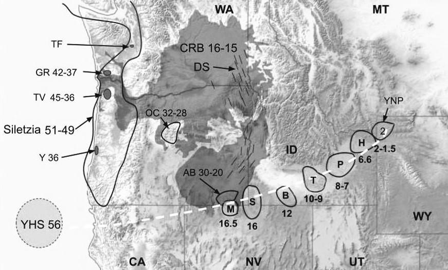
gon coasts known as the Tillamook Episode. This includes the Yachats volcanic field in southern Oregon, which erupted roughly 36 Ma. North of Yachats are the more extensive Tillamook volcanic fields (45-36 Ma), and located in southwest Washington are the Gray’s River volcanics (42-37 Ma) (Figure 14). These lavas possess geochemical signatures that are similar to those of Yellowstone Hotspot lavas, and the timing of the burnthrough is consistent with the timing of the movement of the North American Plate over the Hotspot. But the chemical fits are tenuous, so agree-
ment on this point among geologists awaits further study.
The Yellowstone Hotspot is believed to have been located at about the Oregon/California border roughly 40 Ma, but the logical track of its course does not match these volcanic fields. We will deal with this discrepancy in the next section.
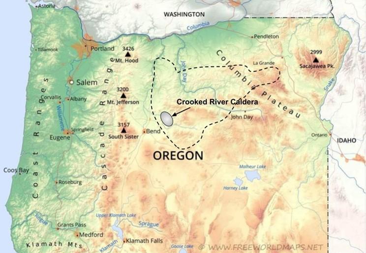
The stationary Yellowstone plume was under central Oregon by about 35 Ma, and more specifically under the Crooked River Caldera 25.9 Ma, where it is thought to also have generated
Figure
Plate
the Yellowstone mantle plume. The buoyant plume disrupts the downward slide of the plate causing its trajectory to flatten and the plate to fracture and disintegrate. A plume flattens out beneath the plate; B lava surges upward through cracks in the plate; C lava spreads out beneath the plate and flows upward around its edges; D upward surging lava creates surface fissures at E; F crust delaminates; G plume rounds the slab as it rolls back. Source: adapted from U.S. National Park Service.
the John Day Formation and perhaps also the Tower Mountain Caldera.19 The largest of these, the Crooked River Caldera, was formed by an ancient supervolcano. The 25-mile by 17-mile caldera lies in a giant oval between Redmond and Prineville, Oregon. It is comprised of welded tuff, a rock made of cooled, hardened volcanic ash, and rhyolite, which is a high-silica lava often associated with cataclysmic volcanic eruptions (Sidebar 2). Volcanism on this scale suggests its formation by a mantle plume, or hotspot.
Direct evidence for a Yellowstone Hotspot genesis of the Crooked River Caldera comes from several lines of reasoning.First, the hot dry chemistry of minerals and rocks in the caldera resemble those at Yellowstone. Ignimbrites (rocks that are formed by pyroclastic flows), and other lavas that are notable for their low oxygen-18 isotopic signatures, match other calderas that are known to have been formed by the Yellowstone Hotspot. The Crooked River Caldera contains what are known as bimodal lavas (lavas with both high- and low-silica contents), typical of lavas associated with the Yellowstone Hotspot track. At this point, the appearance of a strange rock formation called an adakite belt in the southeastern corner of Oregon suggests that the Farallon Plate was then beginning to disintegrate.20 Adakites are believed to be produced by the melting of subducted slabs.
Between 20-17 Ma, there was another three- to five-million-year hiatus in surface volcanic activity throughout
the backarc region. This is hypothesized to have resulted from the buoyant mantle plume continuing to lift the Farallon slab, causing lava to pool up beneath it rather than flowing to the surface.
The above events ushered in a farreaching overall change in the nature of the eruptions that occurred about 15-16 Ma. Beginning about 16 Ma, with the Yellowstone Hotspot no longer trapped beneath the Farallon slab, the upward pressure of the plume basalts created a great labyrinth of fissures called dike swarms. As magma filled these fissures, it formed great fields of basalt dikes in the crust. As it continued to rise to the surface through these fissures, it formed about 300 basalt flows, giving rise to the Columbia River Basalt plateau. As indicated earlier, these flows have buried much of eastern Washington and Oregon under as much as three miles of basalt (Figure 7). The age, chemical composition, and sheer volume of these lava flows suggest that they were very likely to have been extruded from the Yellowstone plume.
Interestingly, some geologists had long held the view that the Columbia River Basalt plateau was the birthplace of the Yellowstone Hotspot. But as we have recently learned, the hotspot is far older than 16-15 million years old, and originated somewhere out in the eastern Pacific. Its ultimate age is unknown, but is believed to be greater than 70 million years. This age discrepancy makes it impossible for the Columbia River Basalt plateau to be
the birthplace of the Yellowstone Hotspot.
By 17 Ma, it appears the slab that had previously existed as the Farallon Plate had completely broken up after subduction, and by 16-10 Ma it had sunk and disintegrated into the mantle. The breaking and subsequent disintegration of the plate left the plume unimpeded in its path of devastation as the continent continued to move over it.
Once the Yellowstone Hotspot was under the East Snake River Plain about 15-16 Ma, it blasted a nearlinear, time-progressive northeast track. Leaving in its wake a distinct line of calderas, volcanic fields, flood basalts, and rhyolite domes, it ultimately arrived at its present location in northwestern Wyoming 2.0–1.6 Ma.
The first of these calderas was named the McDermitt Caldera (16.5 Ma), a major eruptive center just west of McDermitt, Nevada.21 With a keyhole shape, it is roughly 28 miles long by 22 miles wide and straddles the Oregon-Nevada border. The caldera’s volume is estimated to be about 95 cubic miles, and its highest point is 6,816 feet. In the past, some geologists considered McDermitt to be the point of origin of the Yellowstone Hotspot.
As the North American plate continued west, the hotspot track next included the Santa-Rosa Calico volcanic field in northwestern Nevada (16 Ma). Unlike the McDermitt eruptive center, Santa-Rosa contains very few calde-
ras, but rather hosts a full range of lavas from basalt through high-silica rhyolite and dacite.22
The Bruneau-Jarbidge Caldera was a supervolcano that erupted about 12 Ma, its ash and pyroclastic flows killing everything within a hundred miles of the volcano.23 Ash fell as far east as Nebraska and the Great Plains, where up to six feet of it exist to this day in some locations. Bruneau-Jarbidge ash has a unique geochemical footprint that allows it to be identified and singled out from numerous other ancient ash-flows across the country. The Twin Falls eruptive center (10-9 Ma), according to recent work, was another site of a major supervolcano eruption. Its ejecta covered an area of about 4,600 square miles. The Picabo (8-7 Ma) and Heise (6.6 Ma) volcanic fields produced extensive explosive caldera-forming rhyolitic eruptions that lasted for more than two million years.24 Their exact locations have been difficult to pinpoint because they are buried under about 1,600 feet of more recent lava flows, but deep boreholes have revealed clues regarding their nature and extent.
The Yellowstone Hotspot finally arrived at its current location 2-1.5 Ma. Its most recent eruption was about 640,000 years ago with ashfall covering all of Wyoming, Nebraska, and Colorado, as well as portions of South Dakota, Kansas, Oklahoma, Texas, and New Mexico.
It is almost certain that, as the North American plate continues to drift in-
exorably to the southwest, the Yellowstone Hotspot will continue its path beneath Wyoming to Montana and North Dakota. The rate of movement of the plate in the Yellowstone area from 16 Ma to 8 Ma was about 2.4 inches per year, but for the past eight million years it has slowed to about 1.8 inches per year. Using that number, the Yellowstone Hotspot would arrive in Montana in about three million years and North Dakota in seventeen million years, leaving North Dakotans ample time to prepare.
This is believed to be a consequence of plate tectonics. The Juan de Fuca Plate, a surviving vestige of the subducted Farallon Plate, is now subducting in a northeasterly direction just off the northwest coast, while the Pacific Plate is drifting to the northwest. This is dragging the southwest coast of Oregon northward producing an overall northward shear in the North American Plate and thereby twisting the plate northward.
How could this story get any more complicated than it already is?
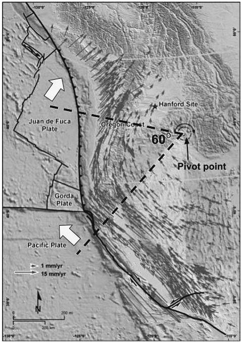
Here’s how. It turns out that while all this was happening, the entire northwest coast of North America has been rotating in a clockwise direction. This odd phenomenon was first detected by geologists studying what are known as paleomagnetic signatures of certain rocks.25 When lava cools, magnetic elements in the still molten lava align their magnetic poles parallel to Earth’s magnetic field. So, when geologists study the cooled and hardened rocks millions of years later, they can deduce the latitude at which the rocks were formed. When the measured alignments of rocks from locations all over the Pacific Northwest were plotted on a map, the results revealed that western North America seemed to be rotating in a clockwise direction, with the pivot point located somewhere in the vicinity of Orofino, Idaho, about 40 miles east of Lewiston.
This rotation has been confirmed during the past several decades by hundreds of GPS transmitters placed throughout the Northwest.26 The recorded GPS tracks reveal that the North American west coast has, indeed, been rotating clockwise at a rate of about 1.19° per million years, with the rate of rotation increasing with distance from the pivot point (Figure 16). This phenomenon is responsible for, among other things, the strange east-west orientation of the Yakima Fold Belt including Manastash Ridge, Umtanum Ridge, Toppenish Ridge, and the Saddle Mountains, while the Cascades, a product of subduction and volcanism, are oriented north-south.
Over 50 million years, a 1.19° shift would amount to about 60° rotation, explaining why the locations of Siletzia, the Oregon Calderas, and Columbia Basalt Plateau are off track from the remainder of the Yellowstone Hotspot trajectory (Figure 16). They have simply moved north above the stationary hotspot.
Figure 16.
indicate direction of plate movement. The length of the small arrows indicates speed of surface rotation from 1 to 15 millimeters/year, based on GPS (Global Positioning System) points. Dark line with triangles is the Cascadia subduction zone. Source: Hanford Sitewide Probabilistic Seismic Hazard Analysis, November 2014, prepared for the U.S. Department of Energy, under Contract DE-AC06076RL01830, and Energy Northwest.
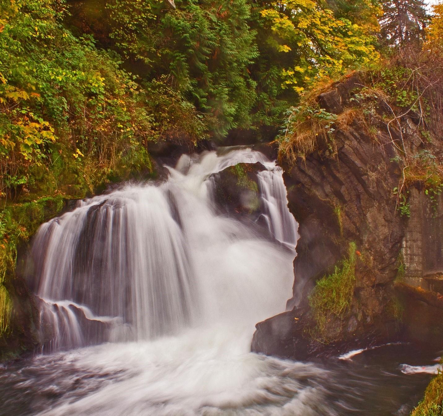
It must have taken thousands of years for the Deschutes River to eat its way through the vast fields of till laid down by the great Vashon ice sheet (discussed below). Cutting down to the Crescent Basalt, it snaked its way many tens of miles out to Puget Sound. And as it did, it created the lovely rapids and cataracts we call Tumwater Falls. Much of Tumwater Falls Park (now called Brewery Park at Tumwater Falls) is fenced off in a manner that makes it difficult to view the native rocks up close. But this is possible at a few spots on the trail on the east side of the river. One is where a tiny waterfall drops down into a pool before it gurgles below the trail down into the Deschutes River (Figure 17). This jet-black rock is Crescent Basalt, part of Siletzia, and here you can feel and admire its shimmering beauty.
For the most part, though, Crescent Basalt is deeply buried and almost completely inaccessible (Figure 8). So where else can one go to see it up close and personal?
Outside the park, the Black
Lake Resources quarry, at 2840 Black Lake Boulevard SW in Tumwater, offers a nearby and extraordinary location for basalt viewing. If you ask the friendly people on site, they may allow you to examine the spectacular columns of Crescent Basalt in the old quarry (Figure 18).
Other good views of Crescent Basalt can be enjoyed when driving through the Black Hills on westbound WA Route 8 (on the right at milepost 19, and on the left between mileposts 13 and 12 and at milepost 7). It is also visible along US 101 a quarter mile west of milepost 362 and just south of 360. Unfortunately, there are few safe places here to stop, get out, and admire the rocks.
The next time you head up to Hurricane Ridge in Olympic National Park, be sure to examine the spectacular display of Crescent pillow basalt between mileposts 10 and 11 on Hurri-
Top: Figure 17. Along the Deschutes River in Brewery Park, a small waterfall on the upper part of the east trail presents a close-up view of 56-49million-year-old Crescent Basalt. Photograph courtesy of the author.
Bottom: Figure 18. Impressive columnar basalt of the Crescent Formation is clearly visible in the Black Lake Resources quarry. The columns evidence the fact that this portion of Siletzia erupted on land above the water line. Note person at lower left for scale. Photograph courtesy of the author.
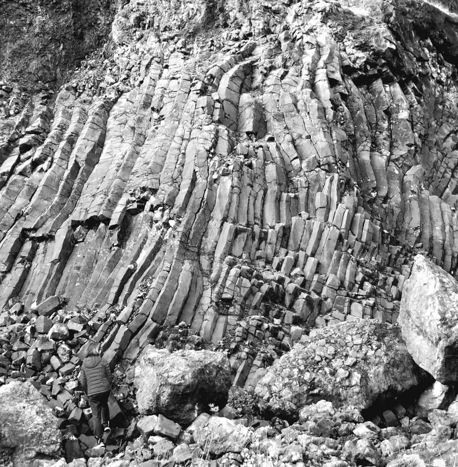
cane Ridge Road. Pillow basalt forms when lava erupts underwater, representing an earlier stage of the eruption of Siletzia. Thankfully, this road offers several safe turnouts.
Two significant geologic events occurred in Thurston County following the accretion of Siletzia. The first of these was the birth and evolution of the Cascade Range (also known as the Cascade Volcanic Arc), which began about 44 Ma and continues to this day. The second event was the dawning of the Pleistocene Ice Age, which began about 2.6 Ma and is also still underway.
Let’s begin with the Cascades. The accretion of Siletzia added more than a hundred miles of real estate to western North America. (The Intermontane and Insular superterranes had already accreted a good deal of land to the west coast.) Importantly, it also added a new subduction zone, which now parallels the coast about 150 miles west of the subduction zone illustrated in Figure 5. As the continent continues to drift westward, the Juan de Fuca plate is being forced downward by the western edge of Siletzia creating a brand-new, linear, volcanic mountain range: the Cascades.
Although most of Thurston County lies west of the Cascades, its southeastern corner holds hidden remnants of some very old Cascade volcanoes: volcanoes, dormant for tens of millions of years, that have largely eroded
away. Figure 19 shows the location of what are called the Gobel Volcanics (named for the town of Gobel, Oregon).27 These are comprised mainly of andesitic basalt and are believed to represent some of the earliest (45-32 Ma) expressions of the original Cascade volcanoes, although more research and geologic mapping are needed to confirm this.28 A remarkable outcrop of the Gobel Volcanics can be seen along the east side of Interstate 5 near the town of Kalama.
Many dozens of giant Cascade volcanoes have come and gone over the past 44 million years. Typically, Cascade volcanoes have a life span of no more than one to two million years, after which they lie dormant as they are eaten away by glaciers, rivers, and other erosive agents. Our five existing active volcanoes are no exception, and will disappear during the next million or so years.
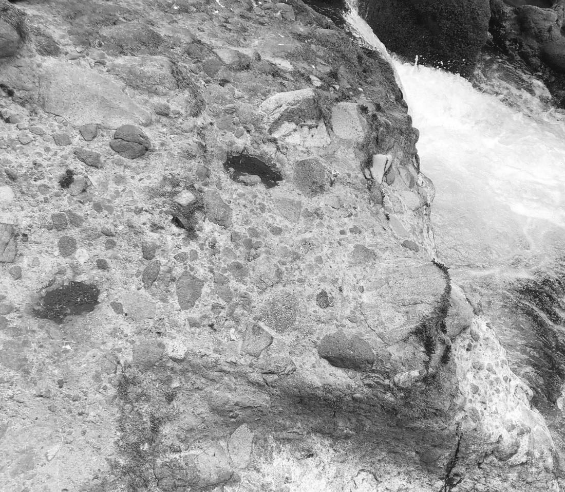
The remnants of these ancient Cascade volcanoes are found mainly to the east of Thurston County. But one such remnant, called the Northcraft Formation (37 Ma), which is likely an eastern extension of the Gobel Volcanics,29 is visible in the southeast corner of the county in Deschutes Falls Park.30 A short hike down an easy path takes you to the falls, where a narrow, rocky trail runs along the Deschutes River shoreline above the falls. If you look carefully at the rocks along the river bank, you will notice that they have an unusual, distinctive appearance (Figure 20).
This beautiful sedimentary rock, called conglomerate, is made up of angular fragments of many smaller rocks; some are dark, some light, some pink, others almost red. All are welded together by a hard matrix of fine, light colored sediment. Notice that these rocks are, for the most part, not touching each other. This is strong evidence that they were formed by a mudslide. Rocks suspended in mud do not settle out when the mud stops
moving; instead, they remain in place in the cement-like matrix. These particular rocks, called andesite and rhyolite, are extrusive volcanic rocks (Sidebar 2), and the matrix is solidified volcanic ash. This type of conglomerate is called a lahar a volcanic mudflow. This lahar undoubtedly thundered down off the side of one of the ancient, now extinct, early Cascade volcanoes.
Falls Park;
Gobel Volcanics;
nearshore marine sedimentary rocks; OV other fragmented volcanic rocks; QA Quaternary alluvial (river) deposits; Qgd Quaternary glacial deposits. Source: simplified and updated from J. Eric Schuster, Geologic Map of Washington State, Washington Department of Natural Resources, 2005.
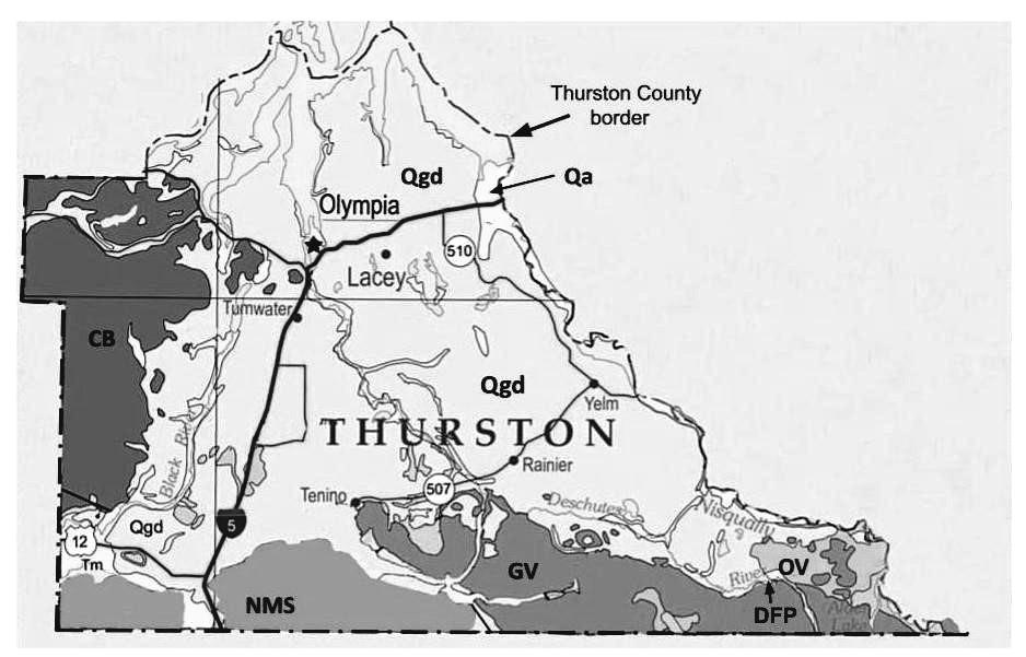
Referring again to Figure 19, note the area labled “NMS nearshore marine sedimentary rocks.” These are primarily sandstones of the Lincoln Creek Formation (Oligocene) and the Montesano Formation (Miocene). The fossil-bearing 5-10-million-year-old Montesano Formation forms a prominent high cliff along the north side of US Route 12 just east of Aberdeen. The sediments that formed these rocks were eroded off the continent and deposited in a shallow sea atop the Crescent Formation.
Thick layers of a fine-grained sedimentary rock called shale occur along the entire western side of the Olympic Peninsula. This shale formed from ocean bottom sediments and has been jammed up against the underlying Crescent Formation during the past 56-18 million years. Tens of millions of years of folding, faulting, and compression of these rocks, caused by the westward-drifting continent, created the spectacular Olympic Mountain range that can be seen from many vantage points throughout the county.
Since the subduction zone that created the Cascades was formed by Siletzia after it ac-
creted to the coast, we can deduce that our beautiful Cascade Range, with its iconic volcanic peaks, is yet another creation of the Yellowstone Hotspot.
THURSTON COUNTYLouis Agassiz was to the Ice Age as Alfred Wegener was to plate tectonics.31 While James Hutton (17261797) and Charles Lyle (1797-1875) are often credited with being the “Fathers of Geology,” they discounted the evidence for glaciation that was abundant in their native Scotland, believing it to have resulted from the Biblical flood. In contrast, Agassiz (1807-1873) was not so persuaded. The Swiss-born American zoologist, geologist, and physician was familiar with the ravages commonly imposed
by glaciers on the landscape, and was well versed in glacial geomorphology. His studies in continental Europe and the United Kingdom, and his close association with other scientists studying glaciated regions, led him and his colleagues to articulate an arresting “Theory of Ice Ages” in the early 1840s.
In 1846 Agassiz immigrated to the northeastern United States where he taught at Harvard and Cornell, and, for many decades, led a scientifically productive and prestigious life. During this time, based on the vast field evidence he had accumulated, Agassiz proposed that much of the northern United States had once been covered by ice up to two miles thick. His ideas were widely accepted by the geologists of his day. So, unlike the less fortunate Wegener, Agassiz attained worldwide acclaim during his lifetime.
Many decades later, however, tantalizing bits of evidence led geologists to posit that there had been more than just one ice age. Lingering debris was found at glacial margins suggesting that the most recent glaciers had plowed over and largely decimated evidence of earlier glaciers. At that time, however, methods of dating rocks and organic materials in glacial debris were yet to be developed, so information on the number and duration of previous ice ages awaited major breakthroughs in technology. Interestingly, such breakthroughs appeared during the late 1950s and early 1960s, about the same time Wegener’s theory of plate tectonics began to gain traction.
Two emerging techniques proved particularly powerful. First was the development of carbon-14 dating of organic material. Based on the rate of radioactive decay of carbon-14 to nitrogen (see Sidebar 1), it became possible to assign fairly accurate dates to bits of wood, peat, and other organic debris trapped in glacial sediments back to about 50,000 years ago the limit to carbon dating. This research revealed that, while much glacial debris in North America was deposited during the past 50,000 years, much of it was older than 50,000 years far older than many geologists had anticipated.
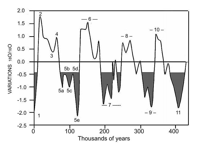
During the 1970s, a vastly more powerful technique emerged, which enabled cores from deep ocean sediments to be extracted, dated, and analyzed. Employing analysis of two isotopes of oxygen, 18O and 16O, one could estimate the sea surface temperatures at the time the sediments were laid down.32 Owing to the fact that deep ocean sediments remain in place undisturbed for hundreds of thousands of years, and are not subject to the ravages of successive glacial advances, such records are beautifully suited to reconstructing ice age chronologies. The oxygen isotope records in these cores revealed that the ice had advanced and retreated about every hundred thousand years for at least the last 800,000 years (Figure 21).
They also showed that we are currently enjoying a very warm interglacial period that followed on the heels of the Vashon glaciation, an extremely frigid 50,000-year period, that was preceded
by another warm interval called the Eemian Interglacial.
Current understanding of the glacial history of Thurston County is limited mainly to the Vashon stage of the Fraser Glaciation (2 4 in Figure 21) and derives largely from numerous studies of surficial glacial deposits, as well as carbon-14 dating of bits of organic material found in these deposits.
The Vashon ice sheet, flowing down the Fraser River Valley from northern British Columbia, reached the Bellingham area about 18,300 years ago (Figure 22). By about 18,200 years ago the ice began to block sea water from entering Puget Sound. Sea level at this time had fallen by perhaps 100 feet, as a huge amount of water was locked up in the worldwide continental ice sheets.
As the ice approached the general latitude of Seattle, it formed a dam that prevented Puget Sound waters from flowing north though the Straits of Juan de Fuca. Fresh water flowing in from the Puyallup, Nisqually, and Skokomish
Rivers then backed up behind the ice dam and created a huge glacial lake called Lake Russell. Roughly 17,700 years ago, the ice reached the Tacoma area. At about this time the southern margin of Lake Russell breached the lowlands to the southwest of Olympia and began emptying west through Black Lake into the Black and ultimately Chehalis Rivers, and then out to the Pacific Ocean via Gray’s Harbor. About 16,900 years ago, the ice fully
Figure 21. Marine oxygen-isotope stages truncated to 400,000 years ago. The numbers within the graph are oxygen isotope stage numbers: the even-numbered peaks (at top) are glacial maxima, while the odd-numbered troughs (at bottom) are interglacial maxima. The dark areas indicate warm, interglacial episodes. 1 current interglacial period; 2 the most recent (Vashon) ice advance; 3 Olympia interglacial; 4 Possession glacial stage; 5 Eemian interglacial. Source: simplified from references in endnote 33.
Figure
Extent of the Vashon stade of the Fraser Glaciation, the most recent of the glacial advances into Puget Sound. Numbers represent the approximate thickness (in feet) of ice at its maximum. Source: Washington Department of Natural Resources; https://www.dnr.wa.gov/programs-and-services/geology/glaciers#thecordilleran-ice-sheet.2.
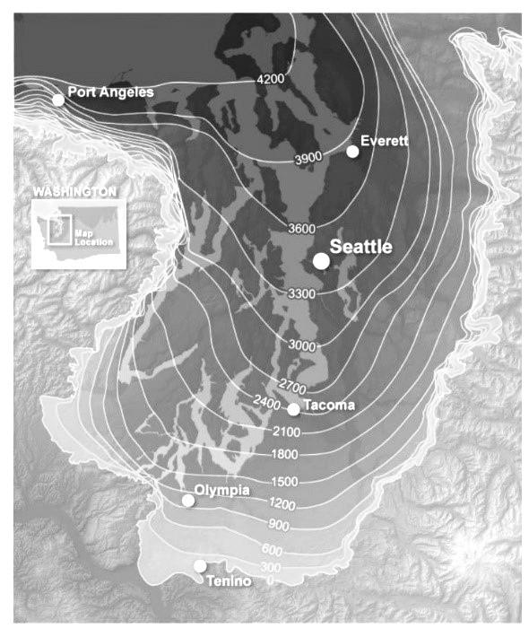
occupied south Puget Sound, and by 12,000 years it reached the general latitude of Tenino. Then it began to stagnate, break up, and recede.
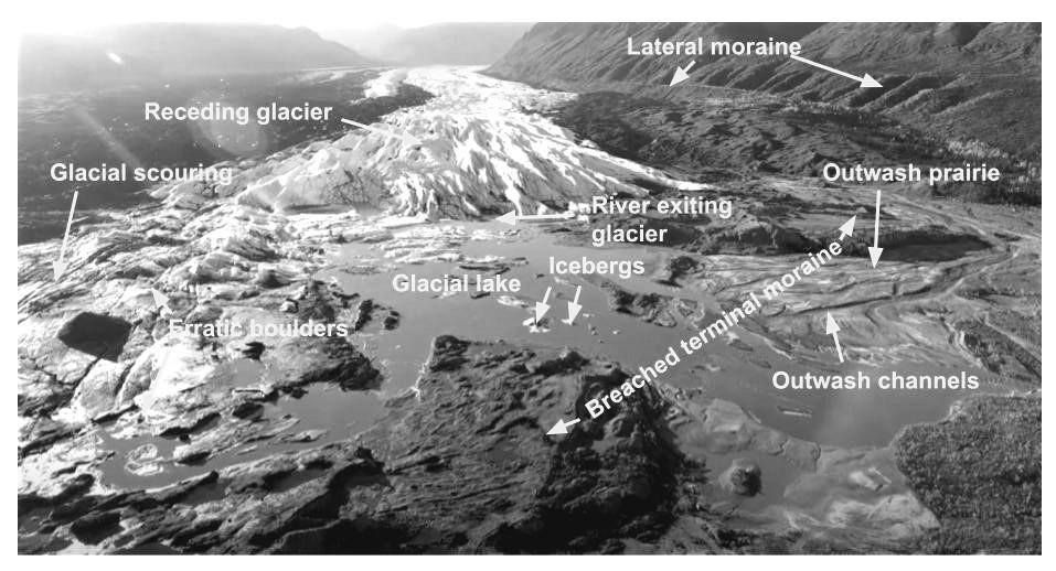
A modern image of the retreating Matanuska Glacier in Alaska illustrates the landscape as it remains following glacial recession (Figure 23). Here the lateral and breached terminal moraines are clearly visible, as is the glacial lake, fed by a river flowing from the base of the glacier. Many other features, such as icebergs, erratic boulders, glacial scouring of underlying bedrock, outwash prairies, and channels, are revealed in this remarkable photograph.
The retreat of the ice in our area was
rapid, perhaps four times faster than its advance. This ultimately allowed Puget Sound to drain north, again flowing into the sea through the Juan de Fuca Straits. Soon after this, the land, having been pressed down by the tremendous weight of ice, began to rebound upward, sea level began to rise, and Puget Sound again became tidal. At the peak of the Vashon stade (a period of time represented by a glacial deposit), the ice covered Thurston County to a maximum depth of about 1,800 feet (Figure 22).
The all-encompassing impacts of the Vashon glaciation on Thurston County can be visualized by referring again to Figure 19. Take note of the large area labelled “Qgd Quaternary glacial de-
posits” (the Quaternary Period includes the Pleistocene and Holocene Epochs).34 During this time, as Puget Sound Country and more than half of Thurston County lay under the ice sheet, the landscape was transformed nearly beyond recognition. Today this glaciated surface can be visualized free of vegetation cover using a ground-imaging technology called LI-
DAR (Light Detection and Ranging) (Figure 24).
The colossal effects of the Vashon ice sheet are apparent just about everywhere we look across the Thurston County landscape. These include such features as:
Glacial till. Glacial till refers to any
https://lidarportal.dnr.Wa.gov/#46.98303:-122.97635.11.;
material carried within and deposited by a glacier (Figure 25). Till is characterized by the great diversity of the material it contains: clay, silt, sand, gravel, cobbles, boulders, and bits of organic debris. It also displays a complete lack of stratification because it was deposited by ice rather than water. Most of Thurston County’s underlying Crescent Basalt is covered by glacial till tens to hundreds of feet deep.
Kettle lakes. Thurston County abounds in small lakes called kettle lakes (Figure 26). When the glacier receded at the end of the last ice age, chunks of glacial ice remained trapped within the till for hundreds of years. As these blocks of ice gradually melted, they left depressions in the land surface. When these depressions occurred above an impenetrable hardpan, such as a clay layer, they filled with water to form lakes. Over thousands of years, these lakes gradually fill in with aquatic vegetation and finally disappear a process called eutrophication. Nearly all of the many blueberry farms in Thurston County are planted in the remnants of old, eutrophied kettle lake beds, where the blueberries are well adapted to the soggy, acid soils.
Erratic boulders. Glaciers scraped up all sorts of debris during the long trek from their frozen northern origin. Prominent among this debris are great numbers of very large boulders. As the glaciers melted away, they left many such boulders visible on the land surface (Figure 27). These are called er-
ratics because they are of a different origin than the local native rock. Occasionally erratics are etched with linear striations wounds incurred as they ground against other rocks entombed within the ice. Erratic boulders also floated across glacial lakes, such as Lake Russell, trapped in icebergs. As the icebergs melted, these ice-rafted boulders fell to the bottom of the lake and now can sometimes be seen along the margins of Puget Sound or in open fields near the water. Erratic boulders litter the landscape all around Thurston County most are granite.
Moraines. When glaciers plow across the landscape, they push large masses of debris in front of them (terminal moraines) and along their flanks (lateral moraines). After a glacier has melted, these moraines are often recognized as linear or curvilinear ridges running across the landscape. The Vashon ice deposited a huge terminal moraine near the latitude of Tenino. It exists today as hilly, wooded terrain that runs for a few miles south of the I-5 Maytown Exit.
Outwash terraces and prairies. Huge volumes of water that continuously flow beneath and within active glaciers generally empty outward from the front of the glacier as it moves downhill. This carries with it sand, gravel, and cobbles rounded from countless miles of tumbling inside the glacial rivers. When this material exits a glacier, it often fans out into large, flat, gravelly-cobbly areas called outwash prairies. When glaciers are advancing,
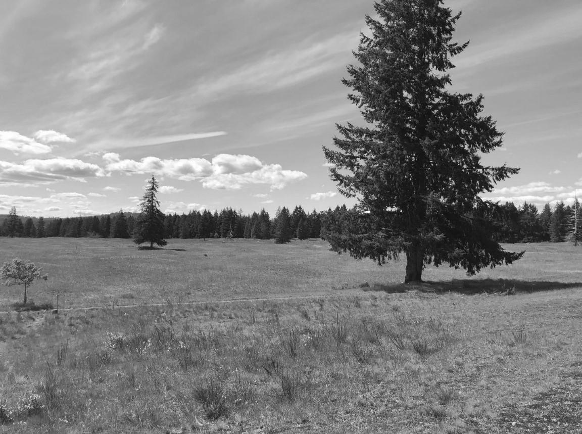
advance outwash is generally covered or obliterated by the moving glacier and is difficult to recognize. By contrast, recessional outwash flows out of a glacier as it is receding; therefore it remains in place and is easily recognizable. Recessional outwash is characterized by large volumes of cobbles and gravel. Outwash terraces and channels form when rivers cross and incise outwash prairies (Figure 28). The several square miles of flat land south of Tumwater, such as the Glacial Heritage Preserve off the Mima Road, offer excellent examples of outwash prairies and terraces (Figure 29).
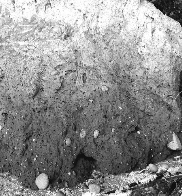
Top: Figure 25. Glacial till displays a great diversity of sizes and types of materials as well as a lack of stratification. This till bank is approximately six feet high, located on a beach near Olympia. Photograph courtesy of the author.
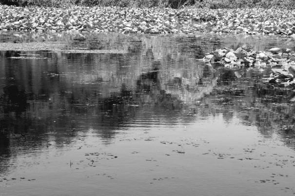
Center: Figure 26. Eagle Lake, a kettle lake near South Bay, showing an invasion of aquatic plants. This natural process, called eutrophication, leads to the formation of peat bogs and other flat basins. Photograph courtesy of the author.
Bottom: Figure 27. This granite erratic boulder near Jubilee displays linear surface striations (upper left to lower right) incurred as it was being dragged by the glacier along the ground surface, or grinding against other boulders entrained within the ice. Photograph courtesy of the author.
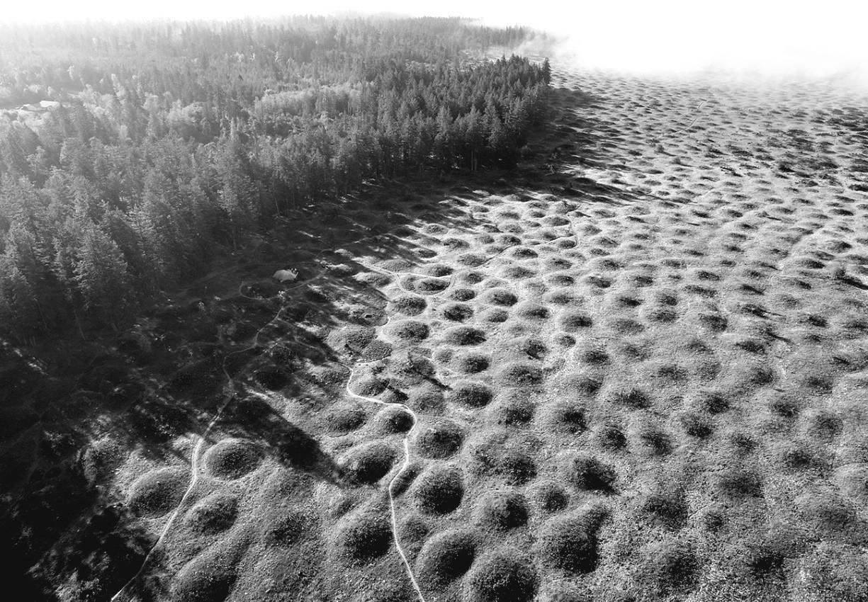
Mima mounds. Mima mounds are unique features occurring on many of the south Thurston County prairies. Mima Prairie, just north of the Glacial Heritage Preserve, is the most famous of these (Figure 30). These enigmatic mounds were initially thought to have been formed by geologic processes associated with frozen soils at the edges of glacial ice sheets. But many other competing theories have been forwarded over the years to explain these mysterious features.35
Eskers. Rivers flowing beneath glaciers drop sediments, which may then be constrained by the ice tunnels though which they flow. When the glacier melts, these snake-like deposits of sand, gravel and cobbles are called eskers. In Thurston County they are often found beneath forested ground and are difficult to recognize.
Drumlins. Glacial ice flowing across a landscape tends to gouge out the ground beneath it, forming linear hills that parallel the movement of the ice. These hills are called drumlins. A few drumlins can be seen in Figure 23, as north-south trending hills running across northern Thurston County.
Ecology. The patterns in which plant communities are arrayed across the landscape directly reflect the existing soils. Glacial deposits form the parent material from which these soils are derived. Dry or excessively welldrained soils such as those found on glacial outwash prairies, support drought-tolerant plants like oaks (Quercus) and prairie grasses
(Festuca). In contrast, trees like ash (Fraxinus) or western redcedar (Thuja) prefer low-lying, poorly drained soils as you might find between eskers or along the marshy margins of kettles or glacial lakes. Willows (Salix) and cottonwoods (Populus) thrive along water courses, which may have originated as glacial drainage channels, while acidloving plants like spirea (Spiraea) and sedges (Carex) abound in peat bogs that may have formed on the heavy clay soils of glacial lake or kettle bottoms. Wildlife, birds, and insects of different species inhabit different types of plant communities based on their adaptations.
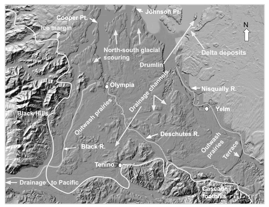
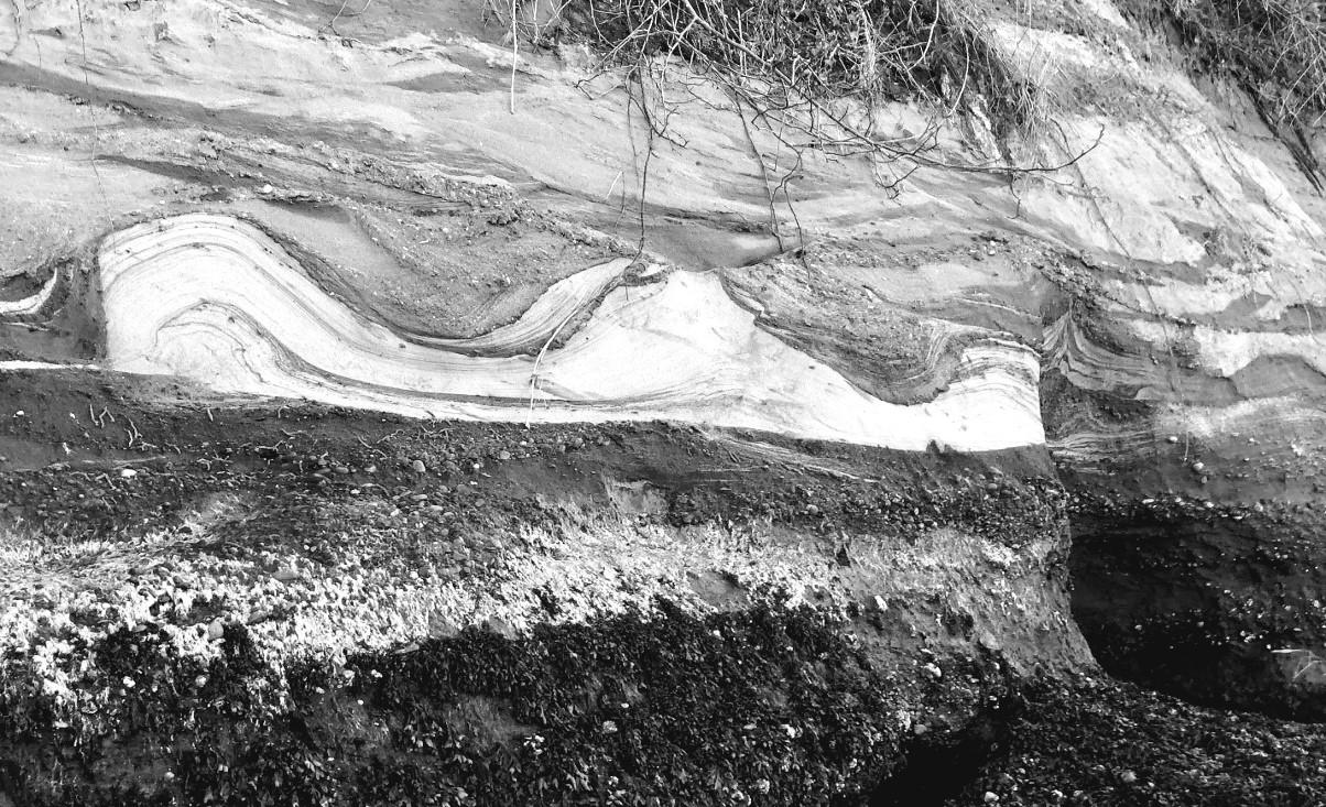
As noted earlier, very few glacial deposits predating the Fraser Glaciation are visible at the surface having been either destroyed or buried by till deposited during the Vashon stage. Vertical Puget Sound bluffs are one notable exception to this rule. Here hundreds of years of wave action have undercut them, exposing deposits lying well beneath the surface. Indeed, nearly all of what is known of the preVashon glacial history of Thurston County has been derived through study and interpretation of bluffs, such as one near Tolmie State Park (Figure 31). Walsh and colleagues offer the following interpretation of this bluff.
The upper eight feet of bluff (Qgof) is silt and fine-grained lake clay deposited in Lake Russell. It contains small pebbles, called dropstones, that dropped from icebergs floating in the lake. It also contains about twenty
Top: Figure 28. Glacial outwash terraces are characterized by gravel and rounded cobbles of various sizes, shapes, and rock types. Photograph courtesy of the author.
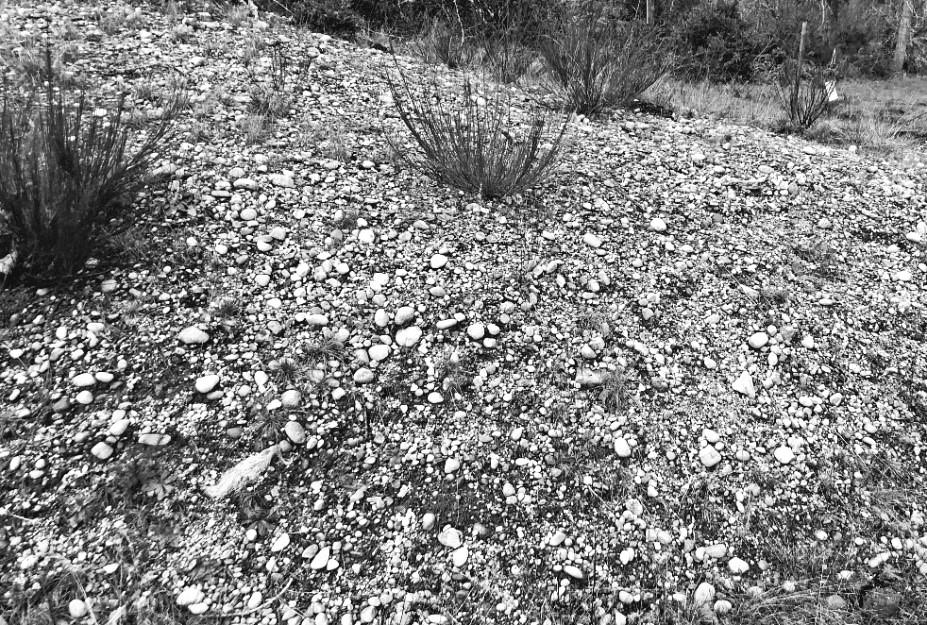
Center: Figure 29. The Glacial Heritage Preserve, owned by Thurston County and Washington Department of Fish and Wildlife, is a remarkable and beautiful example of a glacial outwash prairie. Photograph courtesy of the author.
Bottom: Figure 30. Mima mounds photographed above the Mima Mounds Natural Area Preserve. Note the rapid invasion of Douglas fir (Pseudotsuga menziesii) and other trees to the left. Source: Washington Geological Survey, Unmanned Aerial Vehicle Team.
horizontal layers called varves. These often form as annual layers of sediment and are useful in dating lake deposits. Qgof sediments are found throughout South Puget Sound, commonly below about 140 feet and are deposited directly on Vashon till.
The next ten-foot layer (Qga/Qgt) is made up of Vashon advance outwash sand and gravel. This is underlain by about 50 feet of preglacial fluvial (river) deposits containing peat and wood fragments that date at carbon-14 infinite (greater than 50,000 years old) and are thought to be of oxygen isotope stage 5 origin (Figure 21).
Directly below these deposits lies a layer of striking volcanic ash
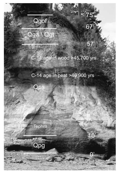
called the Butterball Tephra (Figure 32). Chemical analysis of this ash does not precisely match any known tephras. It is certainly not from Mt. Rainier but may possibly have originated from an older Mt. St. Helens eruption. The lowermost ten-foot layer, Qpg, is a hard, cemented, strongly iron-stained, erosion-resistant gravel. Its structure, which includes a large percentage of northern-origin metamorphic rocks, suggests it has a glacial history, perhaps isotope stage 6 (also known as Double Bluff Drift).
The seafloor oxygen isotope chronology (Figure 21) and other evidence (Sidebar 4) clearly show that North America has continuously cycled into and out of ice ages over the past 800,000 years or more. If this cycle continues, then it is only a matter of time before Thurston County and its surroundings will again be in the grip of another ice age lasting tens of thousands of years. This will leave geologists of the future to speculate about what might lie beneath these vast glacial deposits.
The history of Thurston County did not begin in the 1800s upon the arrival of the first settlers to establish homes, farms, and towns. Nor did it begin thousands of years ago when intrepid aboriginal people trekked across frozen tundra and through boreal forests to seek new hunting and fishing grounds in this untamed, bountiful land. It did not commence tens of thousands of years ago when
the great Vashon ice sheet formed in the far north, destined to bury much of Thurston County beneath hundreds of feet of ice and glacial deposits.
The history of Thurston County began 56 million years ago when the Yellowstone Hotspot exploded beneath the sea, disgorging a 480,000-cubic-mile lava plateau we have named Siletzia. Prior to that time, the area where Thurston County currently exists was under the Pacific Ocean.
Siletzia then accreted to the North American west coast about 49 million years ago, forming a new, massive continental shelf. The subduction zone this shelf created forced the Farallon Plate to dive down into the Earth’s mantle offshore of the original subduction zone. This new zone gave rise to the Cascade Mountains and their splendid volcanic peaks, which stand against the sun as icons of our great and resplendent land.
As the continent continued to drift westward, the Hotspot again erupted 16 million years ago to form the vast Columbia Basalt Plateau. With its spectacular straight-walled coulees and cataracts, formed by Ice Age floods, it buried much of eastern Washington and Oregon under three miles of lava.
Having begun only 2.6 million years ago against the backdrop of such epic events, the Pleistocene Ice Age seems almost an afterthought. Nevertheless, it managed to bury Siletzia beneath great piles of glacial debris across
much of Thurston County, transforming the landscape into the maze of lakes, prairies, moraines, drumlins, and eskers that we call home.
Siletzia, once the dominant landform of the Pacific Northwest coast, now teases us with her mostly hidden splendor, granting only fleeting glimpses of her unseen might: ancient rock shelves peeking out along Hood Canal, or roadcut cliffs in the Black Hills. She resides beneath our houses, churches and schools, Interstate 5, Capital Mall and Tumwater Falls.
Siletzia, our Cascade Volcanoes, Columbia Basalt Plateau, and Tumwater Falls all gifts from the long-departed Yellowstone Hotspot. Gifts to behold.
I am not a geologist. My Ph.D. is in forest biology (University of Washington, 1971) and my only formal training in geology was two elective graduate school geology classes. I, therefore, have had to rely on colleagues and friends with deep expertise in geology for information and assistance. First among them is Nick Zentner, Professor of Geology, Central Washington University. Nick was my inspiration for writing this article. His enthusiasm, great teaching skills, and extensive knowledge of Pacific Northwest geology have given me the courage and desire to pursue, understand, and communicate this very complicated information to others. I hope you will visit his website, www.nickzent ner.com, where you will find nicely
packaged, nearly limitless information on the geology of the Northwest. I am also indebted to Jason McClaughry, Eastern Oregon Regional Geologist, who provided me with a veritable treasure chest of information, much of it based on his own work on Oregon geology, and specifically the Crooked River Caldera. Jason very kindly read through much of the article offering valuable advice and constructive comments. My dear sister Sharon Camp, Ph.D., patiently read through this manuscript twice, bringing to bear her expertise in geoscience and chemistry. Rick Williams, M.D., friend and fellow geology geek, also carefully read the manuscript and offered many thoughtful suggestions. I also wish to thank Karen Johnson of the Olympia Tumwater Foundation, along with Jim Hannum, M.D., who provided thoughtful and cogent editorial services that significantly improved the scope and readability of this article.
1 This geologic time scale begins with the most modern time, the Holocene, and progresses downward through deep time. Geologic Timescale Foundation, 2016; used with permission.
2 Geology is a rapidly evolving science, and as with any science, is rarely ever settled. I have endeavored throughout this document to present the most recent and credible arguments supporting the various geologic perspectives described within. However, as I write this, research is underway and new
When Milutin Milankovitch was a young man growing up in Serbia in the late 1800s, there were no computers, hand-held calculators or calculating machines. Even slide rules (remember them?) had not yet become widely available. Yet his hand calculations, involving the motions of Earth’s trajectory through its orbit around the sun, would lay the groundwork for our modern understanding of what drives the ice age cycles.
Milankovitch reasoned that the relative amount of time the sun shines directly on the north pole would have important implications for Earth’s climate. Less exposure to the sun would enable polar ice sheets to grow. This would provide positive feedback, owing to the high reflectivity of ice to light. The more the ice would grow, the more sunlight would be reflected, the colder it would get, and the ice sheet would continue to enlarge and spill southward.
Milankovitch, a highly trained astronomer and mathematician, had the misfortune of being arrested, owing to his Serbian citizenship, and imprisoned by officials of the Austro-Hungarian Empire at the beginning of World War I. This was followed by his extremely good fortune of being allowed to return to Budapest, then ultimately to Belgrade, which permitted him to work on developing his theory of the causes of the ice ages and, thankfully, avoiding the carnage of the Great War.
He considered three factors to be critical: (1) the eccentricity of Earth’s orbit around the sun, which displays a 100,000-year cycle; (2) changes in the tilt of Earth’s axis between 22.0° and 24.5° (41,000-year cycle); and (3) the procession, or wobble, of the tilt (23,000-year cycle). These factors are influenced by the gravitational pull of Jupiter, Saturn, the sun, and the moon. Taken in concert, these independent cycles control the amount of sunlight (solar energy) that falls on any point on the planet, including the north pole, at any given time.
Milankovitch’s calculations predicted that the interaction of these three factors would result in roughly 100,000-year cycles into and out of ice ages. Such cycles have largely been confirmed by analyses of ice cores from Greenland and Antarctica as well ocean bottom sediment cores (see Figure 21), from which time and temperature data can be extracted. Called “Milankovitch Cycles” in his honor, they currently form the basis of scientific thinking about the ice ages, although they are not totally accepted by the scientific community as the full cause of the ice ages.
papers are being written, any one of which could change the geological interpretations presented herein. In geology, few things are ever “carved in stone.”
3 J. J. W. Rogers and M. Santosh, “Configuration of Columbia, a Mesoproterozoic Supercontinent,” Gondwana Research, Volume 5, January 2002, pages 5-22. Zhaochong Zhang et al., “Geochronology, geochemistry and petrogenesis of Neoproterozoic basalts from Sugetbrak, northwest Tarim block, China: Implications for the onset of Rodinia supercontinent breakup,” Precambrian Research, Volumes 220-221, November 2012, pages 158-176. Lauri Pesonen et al., Ancient Supercontinents and the Paleogeography of Earth, Elsevier, 2021.
4 It has been debated for years that the continent attached to North American during Rodinia time may have been Siberia or Antarctica. The current view is that Australia is the more likely candidate.
5 J. Kious et al., This Dynamic Earth: The Story of Plate Tectonics, U.S. Geologic Survey, Online Edition, 2015 (https://pubs.usgs.gov/gip/dynamic/ dynamic.html, accessed February 1, 2022).
6 The term craton refers to the stable interior portion of a continent. The North American craton is generally composed of metamorphic basement rock covered by sedimentary rock many miles thick.
7 Worldwide, continental plates occupy roughly 30 percent of Earth’s surface, with oceanic plates occupying the remaining 70 percent. Oceanic plates average only about four or five miles in thickness compared to the 25-mile-thick continental plates. Continental plates beneath mountain ranges can approach 50 miles in thickness so, while ocean plates cover more surface area than continental plates, they contain only about half as much rock as continental plates.
8 The ancient Farallon Plate is no longer with us, having completely subducted beneath North America about 30 Ma. Its only remnant is the tiny Juan de Fuca plate, which is located off the Washington and Oregon coasts, where it is now subducting beneath the continent in a northeasterly direction.
9 The word terrane is not to be confused with “terrain,” which is a stretch of land, especially with regard to its physical features. The term exotic terrane refers specifically to a body of land that has accreted to a continent, is different from the continental rocks, and is separated from other terranes by faults. A captivating animation, by Dr. Christopher Scotese, of the accretion of terranes to western North America is found here: https://www. youtube.com/watch?v=2yKNhbY3Nbk.
10 Some other examples of Cascade plutons are the Tatoosh pluton south of Mt. Rainier, the Bumping Lake pluton at Chinook Pass, the Entiat pluton north of Wenatchee, and the Spirit
11 The Siberian Traps, with a volume of about 1 million cubic miles and an area of 2.7 million square miles, is the largest basalt plateau on Earth. Its eruption 251.9 Ma is believed to be responsible for the greatest extinction event in Earth history, the Permian extinction, which resulted in the loss of about 95% of marine and 70% of terrestrial species. The second largest basalt plateau in the geologic record, with a volume of 240,000 cubic miles and area of 193,000 square miles, is the Deccan Traps in northwestern India. Its eruption 66.25 Ma suggests conflicts with the asteroid theory to complicate interpretation of the end of the Cretaceous extinction (66.5 Ma), which wiped out the dinosaurs. (G. Keller, et al., “Mercury linked to Deccan Traps volcanism, climate change and the end-Cretaceous mass extinction,” Global and Planetary Change, 194:103312, 2020.) The Columbia River Basalt plateau (16-15 Ma) is far smaller at a volume of about 41,000 cubic miles and an area of 62,000 square miles.
12 R. E. Wells et al., “Geologic history of Siletzia, a large igneous province in the Oregon and Washington Coast Range: correlation to the geomagnetic polarity time scale and implications for a long-lived Yellowstone hotspot,” Geosphere, Volume 10, 2014, pages 629-719. V. E. Camp and R. E. Wells, “The Case for a Long-Lived and Robust Yellowstone Hotspot,” Geological Society of America, GSA Today, January 2021, pages 4-10. P. A. McCrory
and D. S. Wilson, “A kinematic model for the formation of the Siletz-Crescent forearc terrane by capture of coherent fragments of the Farallon and Resurrection plates,” Tectonics, Volume 32, 2013, pages 718-736.
13 The name Siletzia comes from the Siletz River in northwestern Oregon.
14 M. P. Eddy et al., “High-resolution temporal and stratigraphic record of Siletzia’s accretion and triple junction migration from nonmarine sedimentary basins in central and western Washington,” Geological Society of America Bulletin, published online on September 28, 2015 as doi:10.1130/ B31335.
15 G. E. Mustoe, “Geologic History of Eocene Stonerose Fossil Beds, Republic, Washington, USA,” Geosciences, Volume 5, 2015, pages 243-263, doi:10.3390/geosciences5030243 geosciences.
16 Wells et al., “Geologic history of Siletzia . . .” Camp and Wells, “The Case . . .” McCrory and Wilson, “A kinematic model . . .”
17 B. A. Romanowicz, “Seismic tomography of the Earth’s Mantle,” Encyclopedia of Geology (Second Edition), 2021, pages 587-609. K. Sigloch and M. G. Mihalynuk, “Intraoceanic subduction shaped the assembly of Cordilleran North America,” Nature 496, 2013, pages 50–56. K. Sigloch and M. G. Mihalynuk, “Mantle and geological evidence for a Late Jurassic–Cretaceous suture
spanning North America,” Geological Society of America Bulletin 129, 2017, pages 1489-1520.
18 A. N. Seligman et al., “The earliest low and high δ18O caldera-forming eruptions of the Yellowstone plume: implications for the 30–40 Ma Oregon calderas and speculations on plumetriggered delaminations,” Frontiers in Earth Science, November 2014. J. D. McClaughry et al., “Geology of the North Half of the Lower Crooked River Basin, Crook, Deschutes, Jefferson, and Wheeler Counties, Oregon,” Oregon Department of Geology and Mineral Industries, Bulletin 108, August 2021. Wells, “Geologic history of Siletzia . . .” Camp and Wells, “The Case . . .” McCrory and Wilson, “A kinematic model . . .”
19 J. D. McClaughry et al., “Field trip guide to the middle Eocene Wildcat Mountain Caldera, Ochoco National Forest, Crook County, Oregon,” Oregon Geology, Volume 69, Number 1, Fall 2009, pages 5-24.
20 V. E. Camp et al., “Uplift, rupture, and rollback of the Farallon slab reflected in volcanic perturbations along the Yellowstone adakite hotspot track,” Journal of Geophysical Research: Solid Earth, Volume 122, Issue 9, September 2017, pages 7009-7041.
21 C. D. Henry et al., “Geology and evolution of the McDermitt caldera, northern Nevada and southeastern Oregon, western USA,” Geosphere, Volume 13, Number 4, July 2017, pages 1066–1112 (https://doi.org/10.1130/
GES01454.1, accessed February 1, 2022).
22 M. E. Brueseke et al., “Geology and Petrology of the Mid-Miocene Santa Rosa-Calico Volcanic Field, Northern Nevada,” Nevada Bureau of Mines and Geology Bulletin 113, 2008.
23 B. P. Nash and M. E. Perkins, “Neogene Fallout Tuffs from the Yellowstone Hotspot in the Columbia Plateau Region, Oregon, Washington and Idaho, USA,” PLoS ONE 7(10): e44205 (https://doi.org/10.1371/jour nal.pone.0044205, accessed February 1, 2002).
24 M. H. Anders et al., “A fixed sublithospheric source for the late Neogene track of the Yellowstone hotspot: Implications of the Heise and Picabo volcanic fields,” Journal of Geophysical Research: Solid Earth, Volume 119, 2014, pages 2871–2906, doi:10. 1002/2013JB010483.
25 M. E. Beck, “Paleomagnetic record of plate-margin tectonic processes along the western edge of North America,” Journal of Geophysical Research: Solid Earth, Volume 85, Issue B12, 1980, pages 7115-7131, doi:10.1029/ JB085iB12p07115.
26 R. E. Wells and R. McCaffrey, “Steady rotation of the Cascade arc,” Geology, Volume 41(9), September 2013, pages 1027–1030. R. McCaffrey et al., “Active tectonics of northwestern U.S. inferred from GPS-derived surface velocities,” Journal of Geophysical Research: Solid Earth, Volume 118,
Issue 2, 2013, pages 709–723, doi:10.1029/2012JB009473.
27 M. B. Miller and D. S. Cowan, Roadside Geology of Washington (Missoula, Montana: Mountain Press, 2017), pages 86-89.
28 Clara Phipps and Jeffrey H. Tepper, “Petrology of the Eocene Goble Volcanics, Southwest Washington: an Early Phase of the Cascade Arc,” Sound Ideas, Summer Research, 2019 (https:// soundideas.pugetsound.edu/summer _research/352, accessed February 12, 2022).
29 Wells et al., “Geologic history of Siletzia . . .” McCrory and Wilson, “A kinematic model . . .”
30 Emmett O’Connell, “The Geology of Thurston County’s Upper Deschutes Falls,” ThurstonTalk (https://www. thurstontalk.com/2018/01/14/thegeology-thurston-countys-upper-des chutes-falls/, accessed February 13, 2022).
31 C. Irmscher, Louis Agassiz: Creator of American Science (Boston: Houghton, Mifflin, Harcourt, 2013).
32 Holli Riebeek, “Paleoclimatology: the Oxygen Balance,” Earth Observatory, 2005 (https://earthobservatory. nasa.gov/features/Paleoclimatology _OxygenBalance, accessed January 11, 2022).
33 T. J. Walsh et al., “Pleistocene tephrostratigraphy and paleogeography of southern Puget Sound near Olympia,
Washington,” Geological Society of America Field Guide, Western Cordillera and Adjacent Areas, Volume 4, January 2003, pages 225-236. R. B. Morrison, Introduction, in Roger B. Morrison, editor, Quaternary Nonglacial Geology: Conterminous U.S. (Boulder, Colorado: Geological Society of America, 1991), pages 1-12.
34 Geologically, the Pleistocene and the Quaternary Periods are synonymous, both having begun 2.6 Ma. Some geologists prefer to break out the Holocene, which is post-glacial time, having begun roughly 0.012 Ma.
35 An excellent account of the various theories of the origin of Mima mounds is found in: Dave Tucker, Geology Underfoot in Western Washington (Missoula, Montana: Mountain Press Publishing, 2015).
Dr. Gary A. Ritchie holds a Ph.D. in forest biology from the University of Washington, and has been a plant scientist, author, and lecturer on plant physiology and ecology for 45 years. During retirement, his interests in the natural world have broadened to include geology and the Earth sciences.
This pinnacle is located in Smith Rock State Park northeast of Bend, Oregon. Made of volcanic welded tuff, it is part of the huge Crooked River Caldera. Welded tuff forms when hot volcanic ejecta falls to the ground and becomes cemented to form rock. Recognized as a caldera as recently as 2006, the Crooked River Caldera is among the largest calderas in the world. With an area of about 580 square miles, it is part of the massive John Day Formation and fossil beds (dashed line in the figure below) that occupy much of north central Oregon. The Crooked River Caldera left in its wake a belt of volcanic rocks (mafic basalts, rhyolite domes, lavas, and ash flow tuffs), that covers much of central Oregon. The tuff of Smith Rock contains tiny fragments of limestone, which
formed the original surface rock and were blown to bits by the eruption. Recent and ongoing geologic research supports the view that the Crooked River Caldera was created by the Yellowstone Hotspot as the North American Plate marched over it about 29.5 million years ago, following the Hotspot’s creation of Siletzia (the geologic basis for Tumwater Falls) 56 million years ago. See article for further explanation.
Information from J. D. McClaughry and P. M. Patton, “Smith Rock State Park,” The Oregon Encyclopedia (https://www. oregonencyclopedia.org/articles/smith_ rock_state_park/#.YipMq4nMJGw, accessed February 1, 2022). Map from www.freeworldmaps.net, with annotations by Gary Ritchie.