Number 13 December 2020
An Olympia Urban Legend
Changes in Thurston County’s Bird Populations During the Past Forty Years




The Chambers Black Heart Cherry Tree: A Northwest Icon
Water, Woods & Prairies: A Thurston County History Book $5.00
THURSTON COUNTY HISTORICAL JOURNAL
The Thurston County Historical Journal is dedicated to recording and celebrating the history of Thurston County.
The Journal is published by the Olympia Tumwater Foundation as a joint enterprise with the following entities: City of Lacey, City of Olympia, Confederated Tribes of the Chehalis Reservation, Daughters of the American Revolution, Daughters of the Pioneers of Washington/Olympia Chapter, Lacey Historical Society, Old Brewhouse Foundation, Olympia Historical Society and Bigelow House Museum, South Sound Maritime Heritage Association, South Thurston County Historical Society, Thurston County, Tumwater Historical Association, Yelm Prairie Historical Society, and individual donors.
Publisher
Olympia Tumwater Foundation
John Freedman, Executive Director
Lee Wojnar, President, Board of Trustees
110 Deschutes Parkway SW P.O. Box 4098 Tumwater, Washington 98501
360-943-2550
www.olytumfoundation.org
Editor
Karen L. Johnson 360-890-2299
Karen@olytumfoundation.org
Editorial Committee
Drew W. Crooks Jennifer Crooks
James S. Hannum Erin Quinn Valcho
Obtaining a Copy of the Journal
The Journal does not offer a subscription service. To get your own copy, join one of the heritage groups listed at the top of this page. These groups donate to the publication of the Journal, and thus receive copies to pass on to their members. Issues are also available for purchase at the Bigelow House Museum, Crosby House Museum, and Lacey Museum, and occasionally at Orca Books in downtown Olympia and Hedden’s Pharmacy in Tenino.
One year after print publication, digital copies are available at www.ci.lacey.wa.us/TCHJ.
Submission Guidelines
The Journal welcomes factual articles dealing with any aspect of Thurston County history. Please contact the editor before submitting an article to determine its suitability for publication. Articles on previously unexplored topics, new interpretations of well-known topics, and personal recollections are preferred. Articles may range in length from 100 words to 10,000 words, and should include source notes and suggested illustrations.
Submitted articles will be reviewed by the editorial committee and, if chosen for publication, will be fact-checked and may be edited for length and content. The Journal regrets that authors cannot be monetarily compensated, but they will gain the gratitude of readers and the historical community for their contributions to and appreciation of local history.
Opinions expressed by contributors are not necessarily those of the Olympia Tumwater Foundation.
Written permission is required to reproduce any part of this publication.
Copyright © 2020 by the Olympia Tumwater Foundation. All rights reserved.
ISSN 2474-8048
Table of Contents
Number 13
December 2020
2 An Olympia Urban Legend
James S. Hannum, M.D.
17 Changes in Thurston County’s Bird Populations
During the Past Forty Years
Kim Gale Adelson
31 The Chambers Black Heart Cherry Tree: A Northwest Icon
Deborah Jane Ross
43 Water, Woods & Prairies: A Thurston County History Book

Ann Olson
Back Cover
Who/What/Where Is It?
On the cover:
Top left: Glaucous-Winged Gull. Photograph by Alan Schmierer.
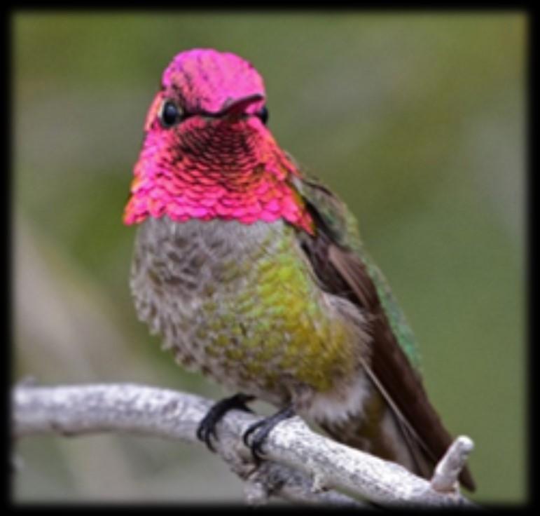
Top right: Anna’s Hummingbird. Photograph by Nate Gowan, Great Backyard Bird Count; used with permission of the National Audubon Society.
Bottom left: Bald Eagle. Photograph by Daniel Joppich, Audubon Photography Awards; used with permission of the National Audubon Society.
Bottom right: Barrow’s Goldeneyes. Photograph courtesy of Yellowstone National Park Service.
See article on page 17.
1
URBAN LEGEND
James S. Hannum, M.D.
Throughout recorded history, underground tunnels have been a fascinating part of popular culture. The reported use of such tunnels has ranged from the mundane to highly secret, covert activities. In the southern part of Puget Sound, several tunnels have been the subject of discussion. Some actually do exist. The presence of others, although mentioned now and then, seem impossible to verify.
DOCUMENTED
THURSTON COUNTY TUNNELS
Among the mundane is the system of underground tunnels at The Evergreen State College. These passages are used as conduits for utilities and can accommodate the workers who maintain those utilities. An image of one of these tunnels was posted April 18, 2015 to the online website Imgur.1 The same website presented a map of the tunnels on August 18, 2015.2
A tunnel connects the lowest level of the Washington State Archives to the Highways-Licensing Building, located east of the archives. The passage spans the entire east-west dimension of the archives building and runs almost directly east, ending at the Highways-Licensing Building. Within the archives, it is accessed through a hatch on the floor of the lowest level.
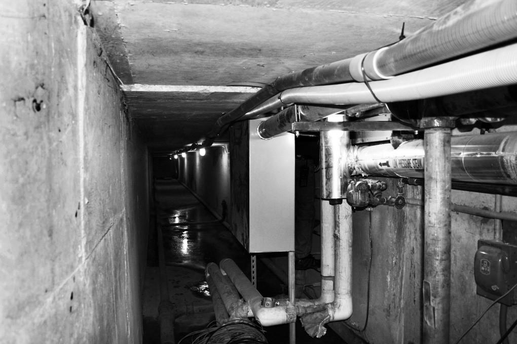
This tunnel was constructed during the Cold War (which lasted from approximately 1947 to 1991). Benjamin Helle, Research Archivist at the Washington State Archives, provided a blueprint showing the front elevation of the Archives Building. Part of that image is seen in Figure 1. Figure 2 is a recent photograph taken by Helle within the tunnel. He adds that an additional tunnel exists between the Pritchard Building (a previous location for the Washington State Library) and the Legislative Building.
Another system of tunnels can be found in Tumwater. Paul Knight, formerly a brewmaster for the Olympia Brewing Company, recalls3 that most buildings of the post-Prohibition brewery complex are connected by an extensive network of underground passages.
UNDOCUMENTED OLYMPIA TUNNELS
Now we will consider other tunnels, the existence of which cannot readily be documented. Relevant background information concerning the Urban Onion Restaurant includes the fact that the eatery closed in 2015 after operating for several decades in Olympia’s Olympian Hotel, at 116 Legion Way SE. The website reddit hosts a subred-
2 AN O
LYMPIA
dit labelled “r/Olympia,” to which a contributor (identified as “the poneychief”) posted a thread titled Underground tunnels downtown? in March 2019. A question was posed: “I
recently heard about a bunch of underground tunnels downtown and that there was a door in the basement of the urban onion but I’m pretty sure that door is chained so I can’t get in that way is there any other way I can get to these tunnels?”4
Somewhat later, “cascadewrench” posted to the thread: “I’ve heard the same rumors 15+ years ago and I can verify most of them except any tunnels existing. The door you’re referring to is an old coal chute for when the boiler for the building was coal-fired, but the ‘tunnels’ are just [a] crawlspace that’s occupies part of the basement for utilities. It’s basically a pipe chase for the hotel and the retail stores on Washington.”

Shortly thereafter, “Willow Rose225” chimed in: “Could they maybe be talking about that old prohibition tunnel between [the] spar [restaurant] and the bank?”
To that query, “cascadewrench” replied: “I’ve never heard of the ‘prohibition tunnel’ going to the bank from the Spar, I have heard that it used to run to the old state capitol building by Sylvester Park though. What’s under the Spar is their artesian well room . . .”
Approximately one month later, posting on the thread returned to the topic of tunnels under the Urban Onion Restaurant. “tgold8888” posted: “Yes the old underground city. About 7 stories down and the elevator at the
3
Top: Figure 1. Front Elevation, Construction Blueprint for Archives Building, DES/General Administration Department, Engineering and Architectural Files, Washington State Archives, Archives Building, Olympia.
Bottom: Figure 2. Tunnel from Archives Building to Highways Licensing Building. Photograph by Benjamin Helle, Research Archivist, Washington State Archives.
Herb & [sic] Onion had a down button. Knew a guy named Sage that went down there. Had Shops, Storefronts even sidewalks.”
A TUNNEL IN CENTRALIA
Although Centralia, Washington is not within Thurston County, a tunnel reportedly located there illustrates how some stories about a secret passage might have originated. Nancy Bartley, a Seattle Times staff reporter, submitted a December 5, 2002 article about Centralia and McMenamin’s Olympic Club, a restaurant, bar, and hotel located at 112 North Tower Avenue. In her article, Bartley quoted Kenneth Moore, “the manager at the vintage, red-brick Union Station where the Amtrak from Seattle stops”: “During Prohibition there was a tunnel running from the hotel, beneath the tracks, to a house on the other side. They were running hooch through there . . . When they put in the new platform, they found a body.”5
The Ellensburg Daily Record published an article by Pat Muir, “Centralia Turns Downtown Around,” on November 11, 2004. The author mentioned:
“Among the city’s main attractions are the refurbished Olympic Club hotel on Tower Avenue, a McMenamin Brothers property; . . . For instance, the Olympic Club has a trapdoor leading to underground tunnels . . .”6
Brittany Walker is the current property manager for the Olympic Club. She kindly provided a tour of the premises.
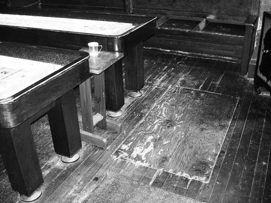
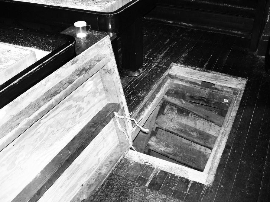
Figures 3 A and B show the trapdoor

4
Figures 3 A, 3 B, and 4. Trapdoor, stairs, and coal chute in McMenamin’s Olympic Club, Centralia. All photos by author, July 2019.
in the northeast corner of the pool room. Descending the steps under the trapdoor, we entered a space about ten feet wide and twelve feet long. At one end was a rusty stove. The other end, the foundation for the back wall of the building, is seen in Figure 4. A long-unused coal chute is visible. A small amount of light came through a tiny, remaining opening to street level.
Figure 5 bears on the notion of a clandestine tunnel between the Olympic Club and the railroad. Created June 30, 1917, this image is part of a Northern Pacific Railroad Valuation map. At that time, the Frye-Bruhn
Spur track lay immediately behind (east of) the structure that currently houses the Olympic Club. The March 19, 1909 issue of Centralia’s The Daily Chronicle reported that the Frye & Bruhn Company had started construction of a two-story brick building on Tower Avenue, “next to the Home Bakery & Café,” which was located at 122 Tower Avenue.7
It seems likely that during Prohibition, 100 years ago, the building’s coal chute would have been used for any clandestine liquor delivery, rather than a much longer tunnel. On the other hand, with a rail spur so close to

5
Figure 5. Railroad Valuation map, Station Map Tracks & Structures, Centralia, Lewis County, Washington, Northern Pacific Railway, Tacoma Division, Main Line, Office of Chief Engineer, St. Paul, Minnesota, (V-6/ST&S 7a), June 30, 1917. Washington State Archives.
the rear of the Olympic Club, liquor might just as well have been brought in through the back door! At this late date, it is impossible to know precisely what was going on at the rear of the building.
ANOTHER OLYMPIA TUNNEL— AN URBAN LEGEND
With this as background, one of Thurston County’s urban legends can be placed in perspective. MerriamWebster’s dictionary defines an urban legend as: “an often lurid story or anecdote that is based on hearsay and widely circulated as true.”8 In Olympia, one such story with those characteristics has been around since at least the early 1930s, and perhaps earlier. With minor variations, I have heard it from several sources, over the past couple of years.
Most versions of the tale narrate that a secret passage connects the building at 600 Washington Street, next to Sylvester Park in downtown Olympia, to a tunnel (called the Olympia subway) built about 1891 as part of the Northern Pacific Railroad. Some accounts of the passage hold that it was used by state legislators arriving or departing by train; they were able to avoid inclement weather by using a platform within the tunnel, at the south end of the passage. Sometimes, the passage is said to have been used during Prohibition to bring alcoholic beverages into the Old Capitol Building.
three blocks long. It is visible in Figure 6, which is part of a Northern Pacific Railroad Right-of-Way Plat Map. The “Old State Capitol Building” in Block 26 displays an inaccurate representation of that building’s floor plan. Purportedly, that structure is where the secret passage originates. The building currently houses the Washington State Office of Superintendent of Public Instruction. However, when built in the early 1890s, it was used as the Thurston County Courthouse. The original structure was purchased by the State of Washington in 1901 and became the state’s capitol. Construction of the Annex, immediately to the east, was begun that same year and completed in 1905. The Superintendent of Public Instruction moved into the finished building in 1906. Together, the original building, plus the Annex, is known today as the Old Capitol Building.
The railroad tunnel, running east and west, lies under 7th Avenue and is
The Washington State Archives maintains a rather complete set of early Olympia City Council records. The Council approved Ordinance Number 399 on June 10, 1890. It authorized construction of the 7th Avenue tunnel by the Tacoma, Olympia & Grays Harbor Railroad (a construction railroad controlled by the Northern Pacific). The tunnel was to be 40 feet wide, with timbered walls, and covered with planking such that 7th Avenue, above the tunnel, remained safe for travel by the public. There was no mention of a stairway connecting the tunnel to street level, or a passage from the tunnel into any nearby building.
6
Ordinance Number 1190 was approved February 8, 1912 by the City Council. It provided for concrete reconstruction of the 7th Avenue tunnel.
“Said subway shall be so constructed that its outer walls shall be at the property line on either side of said Seventh Street; said outer walls extending below the surface of the ground sufficient distance to obtain proper foundations, . . . Two inner walls to said subway shall be constructed, one upon either side of the center line of Seventh Street and eight feet distant therefrom when measured
at right angles thereto, and the center line of the railroad track to be presently operated by grantee through said subway shall be the same as the center line of said Seventh Street.” Again, neither stairs nor a passage out of the subway was described.
Figure 7 comes from the 1896 Sanborn Fire Map of Olympia. The Thurston County Courthouse occupied the west half of Block 26. The same block, from the 1908 Sanborn map, is visible in Figure 8. The Annex had been added, immediately east of

7
Figure 6. Sheet 39, Right of Way Plat Map, Northern Pacific Railway, Olympia Branch (Lakeview to Gate). Thurston County Assessor.
Top: Figure 7. Olympia, Washington, June 1896, Sheet 9.
Bottom: Figure 8. Olympia, Washington, August 1908, Sheet 8. Both images from Digital Sanborn Maps 1867-1970, Timberland Regional Library, http://sanborn.umi.com.ez. trl.org/splash.html.
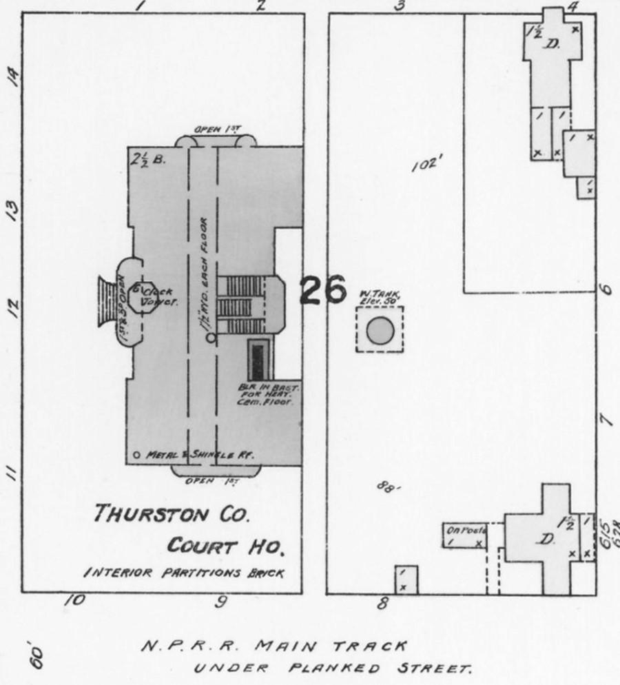
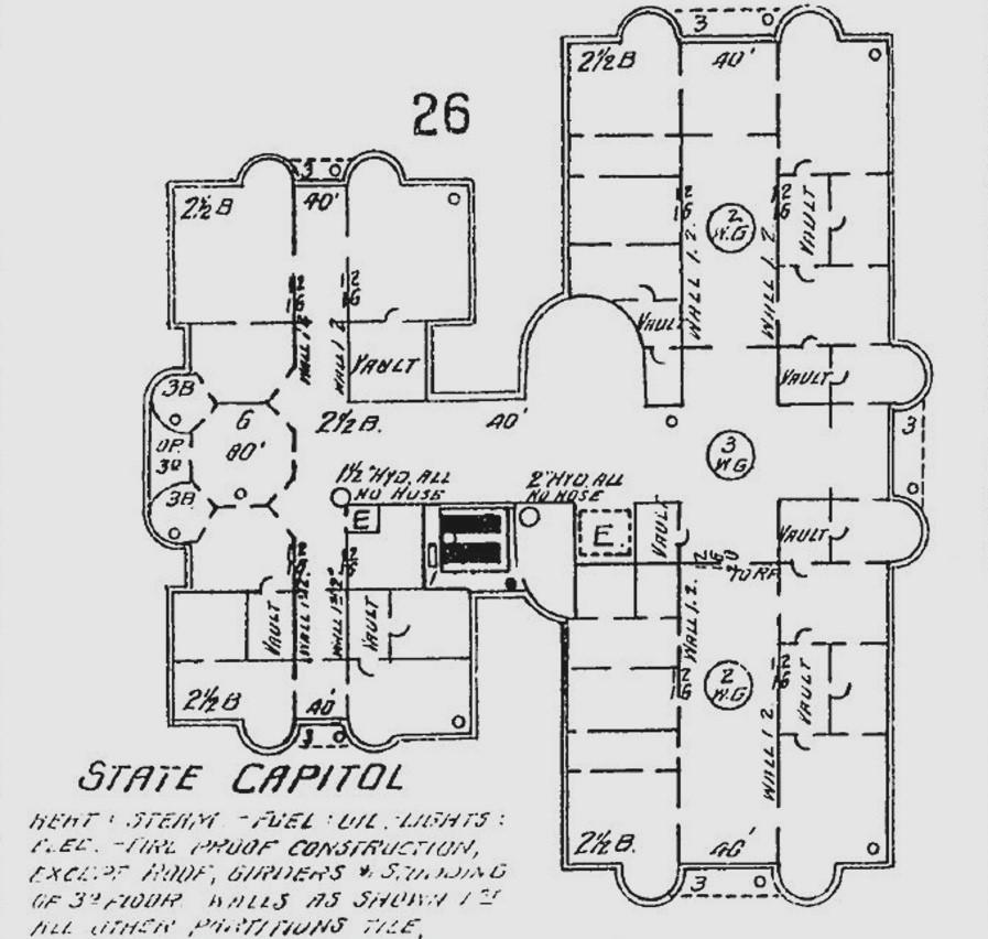
the original courthouse building. Figure 9 is a 1901 photograph presented courtesy of the Washington State Historical Society. The view is toward the southeast, at the groundbreaking ceremony for the Annex. The large stone structure is the back (east) side of the former Thurston County Courthouse. On the far left is the slightly elevated, wood-planked roadway of 7th Avenue; beneath that roadway was the Northern Pacific Railroad subway.
Brian Ferris is a long-time Olympia resident who has a continuing interest in local railroad history. Via email,9 he informed me of a story his mother told him many years ago. “I remember my mother telling me that as a young girl (late 1920s - early 1930s) she rode the NP from Aberdeen to Olympia, to visit her grandmother, who lived near the east portal of the 7th Avenue tunnel. She recalled hearing that there was a station inside the tunnel, which the legislators had previously used to come to Olympia. I think she said it was boarded up and no longer used at that time, which would make sense if the 'new' capital was finished in the late '20s.” It was not clear to Ferris whether she had personally seen something noteworthy in the tunnel, or had merely been told about it by other family members.
Jim Sabol wrote the following to me in a recent email:10 “My uncle (Bill Hiblar11) worked in the old state capitol building and, while I was visiting him sometime in the late 1970s, asked if I would like to see something about railroading, which he knew I was in-
8
terested in. ‘Sure!’ So he took me down to the basement and showed me where the access to the NP train ‘platform’ penetrated the south wall of the building. By that time, it was covered over-I can’t remember with what-as much as possible to make it look as if there were no opening. My shaky recollection is that the portal/access might have been eight to ten feet wide. I have never been inside the tunnel. My use of the word ‘platform’ is pure guesswork-it must have been just a minimal something on which to step off. Probably an extension of the foundation itself.”
I talked personally with Bill Hiblar on July 10, 2019. He retired as State Supervisor of Traffic Safety Programs and is now about 90 years of age. His recollection is that he never went into the passage, from within the building, for it appeared to be closed off by the time he worked there. Curiosity did lead him to enter the railroad tunnel once. While there, a feature was observed which led him to conclude that it represented the remnant of a platform, on the north side of the single track passing through the tunnel.

Several years ago, I had the opportunity to look through the personal
archive preserved by Jim Frederickson at his Tacoma home. He was a Northern Pacific Railroad telegrapher during his entire working career, beginning about 1940. When that railroad was merged into the Burlington Northern Railroad in 1970, most of the older Northern Pacific records at Tacoma were simply tossed into a dumpster. Fortunately, Jim retrieved them. Those documents now reside at the Pacific Northwest Railroad Archive in Burien, Washington. Unfortunately, very few of the Thurston County records from the period before 1900 have been preserved, and the 1891 Northern Pacific construction records for the 7th Avenue tunnel have not been located. Thus, if a stairway had connected the interior of the tunnel with the street above (now 7th Avenue, pre-
9
Figure 9. Breaking Ground for Annex to Old State Capitol Building, 1901. Catalog ID Number: C1958.181X.1, Washington State Historical Society.
viously called 7th Street), a record of such might no longer exist. Certainly, a stairway was not present after the tunnel was rebuilt during 1913 and 1914.

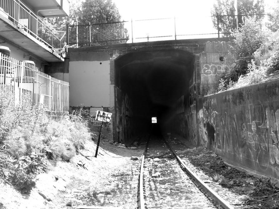
date up to three tracks, although no more than one was ever operated. Figure 10 is a 2019 view of the east portal, while Figure 11 depicts the west portal. Nowadays, there is no connection between the space carrying the existing track and the galleries on either side of it. Moreover, all entry to the side galleries has been sealed off, at the east and west portals. Gregory Wright, the recently retired Chief of the Olympia Fire Department, wrote me via email:12 “I have been in the tunnel in question, but under fire conditions, so I would not say that I have done a complete inspection. Unfortunately, now the tunnel is not very safe due to homeless people and the side tunnels are blocked off because of the homeless starting fires.”
Current inspection of the east and west tunnel portals reveals that the subway was designed to allow later expansion, so that it could accommo-
In a subsequent email, Wright wrote: “The south side (gallery) was closed off earlier, probably after 2000. The north side, more recently, maybe 2015.” He added that, before the galleries were sealed off, the fire department would often be called in there every few months. His recollection is that those fires were burning in items brought in by transients, not in wooden material left over from when the tunnel was constructed. Most of the fires he attended were in the gallery on the north side of the tunnel (which remained accessible for many years after the one on the south side was sealed). Wright never saw anything in the tunnel that was consistent with a railroad platform or a passage leading toward the Old Capitol Building.
10
The subway tunnel under 7th Avenue
Top: Figure 10. East portal of 7th Avenue Tunnel.
Bottom: Figure 11. West portal of 7th Avenue Tunnel. Both photos by author, July 2019.
Above: Figure 12. Olympia Subway, September 16, 1913. Catalog ID Number C1984.3.1.
Right: Figure 13. Olympia Subway, November 12, 1913. Catalog ID Number C1984.3.2. Both photographs courtesy of Washington State Historical Society.
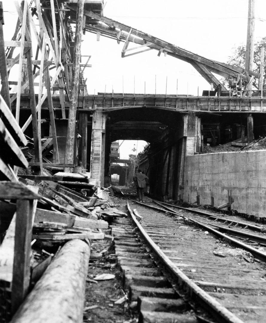
and the roadway above it were rebuilt during 1913 and 1914. Figures 12 and 13 appear thanks to the Washington State Historical Society. Figure 12 is dated September 16, 1913. The view is toward the east, from the approximate position (in 2019) of the parking area immediately south of the firm doing business as Olympia Supply. In the image, an inclined trestle is visible. It probably allowed tracked carts to deliver building materials, including concrete, to the work site. Made about two months later, Figure 13 is a November 12, 1913 image which looks in the same direction; it was obtained closer to the west portal of the tunnel.
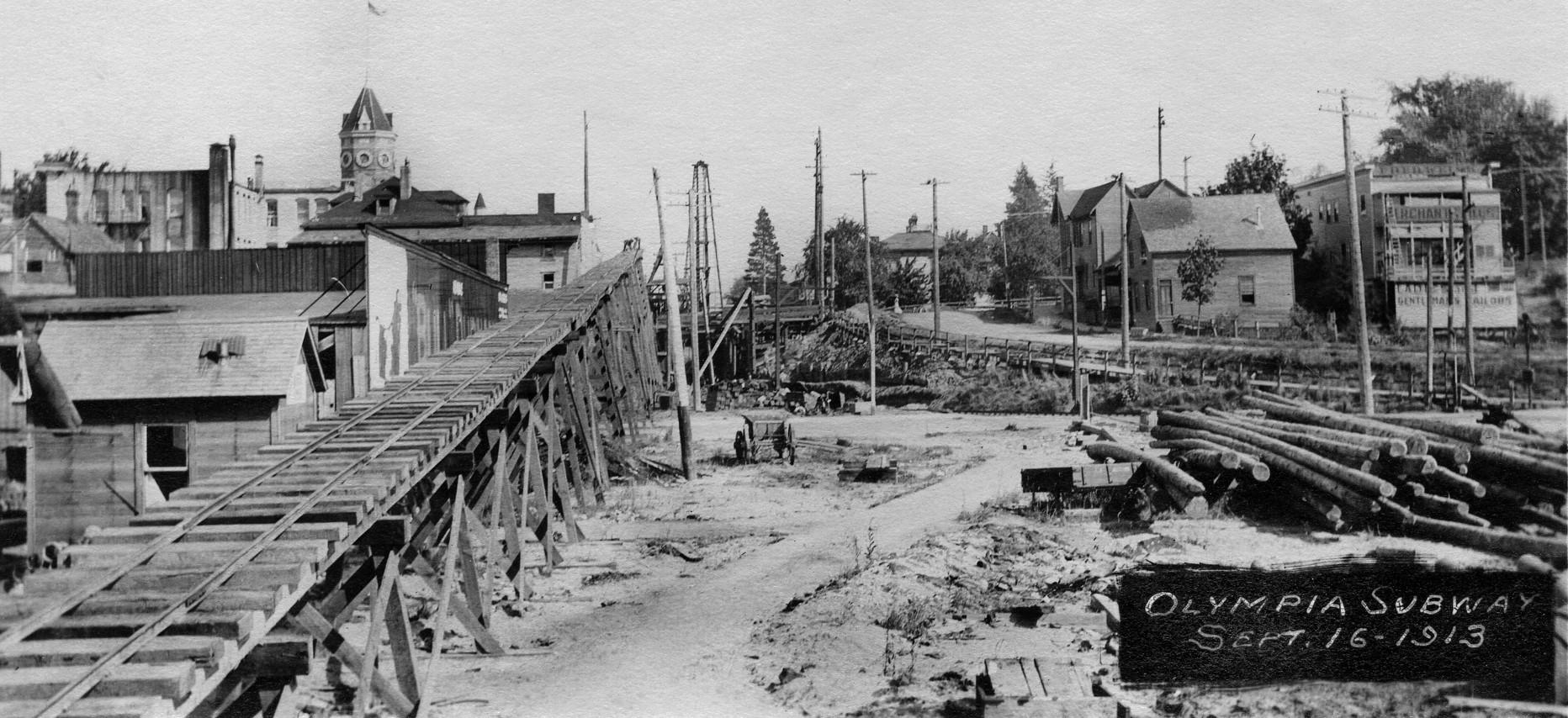
Paving of 7th Avenue, over the subway, was completed in 1914.
If the Northern Pacific Railroad had had a passenger train station stop
11
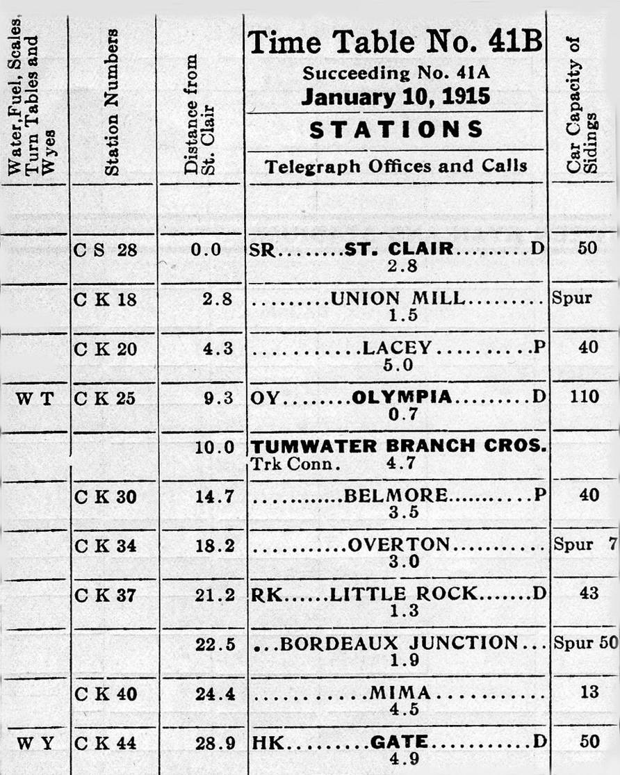
within the 7th Avenue tunnel, even if it were only used seasonally, it should have appeared on periodic timetables issued by the railroad, one or two times per year. Figure 14 is a representative timetable dated January 10, 1915. It comes from the collection of Jim Frederickson. Neither it, nor any of the other timetables dated between 1900 and 1919, contain a reference to a stop within the tunnel.
Special rules for each subdivision were also included in each timetable. Rules appearing in the November 11, 1923 timetable are similar to those preceding it. SPECIAL INSTRUCTIONS-Second Subdivision (Grays Harbor Line) specifies, in detail, how traffic through the Olympia subway tunnel was controlled: “At Olympia-Tunnel district is protected by automatic electric disc signals located as follows: No. 1 (large disc) just west of passenger station. No. 2 (large disc) just east of passenger station. No. 3 (switch indicator) at east end of passing track. No. 4 (large disc) just east of tunnel. Eastward trains or engines finding signals 1 or 2 at stop will protect against westward trains coming out of tunnel. Signal No. 3 will govern eastward movement from passing track. Trains or engines coming from Jefferson Street line must have clear indication from signal No. 4 before opening main track switch.”13 Clearly, there were no special instructions for passenger trains stopped inside the tunnel.
Marygrace Goddu is Olympia’s Historic Preservation Officer and a Senior Planner in the Community Planning
Figure 14. Tacoma Division Timetable 41B, page 5, January 10, 1915, Northern Pacific Railway Company, currently archived at the Pacific Northwest Railroad Archive, 425 SW 153rd Street, Burien, Washington.
and Development Department. She previously worked as the Cultural Resources Manager for the State Capitol Campus, and in that role worked on various projects related to preservation of the Old Capitol Building, including projects to halt water intrusion at the building’s foundations, on the east (7th Avenue) side. While she will not rule out the possibility of something yet undocumented having existed there, her personal inspections of the building’s interior foundation walls never revealed any feature
12
suggestive of a secret passage heading toward the 7th Avenue tunnel.14
Results of the last major inspection of the Old Capitol Building were released by the consultant, Peter Meijer Architect, PC in March 2015. The full report runs to 122 pages and is exceedingly thorough. Special attention was given to the building’s foundation footings in
view of continuing problems with water intrusion. Drainage systems were examined using fiber optic video camera technology. A diagram of the results appears in Figure 15.
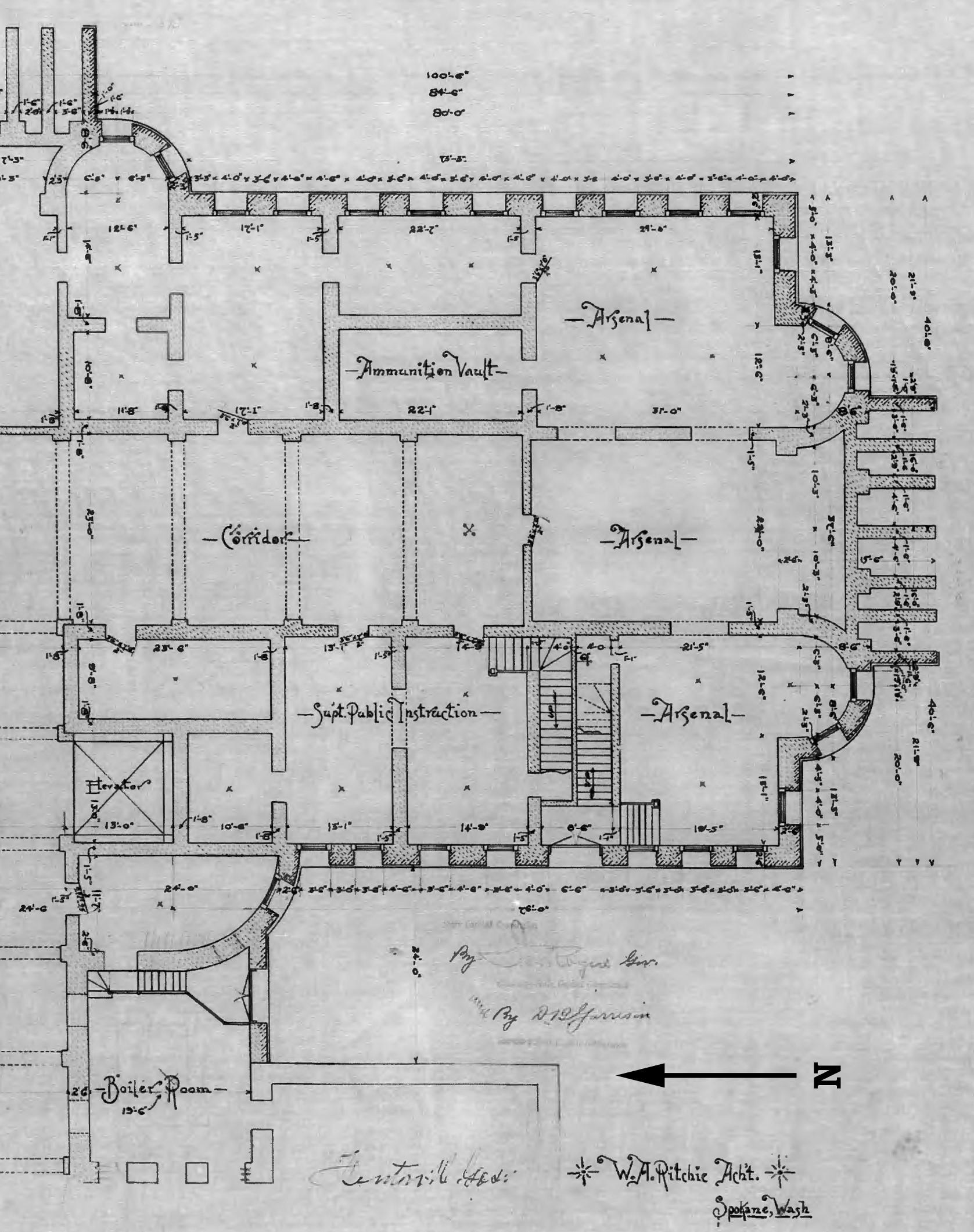
If a secret passage ever existed, it almost certainly would have to have been under the steps on the south side of the Annex. The Washington
 Figure 15. Proposed Drainage Infrastructure, Old Capitol Building, LPD Assessment Drawings, Appendix D, Sheet 2. Peter Meijer Architect, PC, April 11, 2014.
State Archives provided the architectural plan used in constructing the Annex foundation. Relevant parts of that plan appear in Figure 16. Figure 17 is a 2019 photograph of those steps, next to 7th Avenue. Figure 18 is an image made within the lowest level of the Annex, in the printing room of the Office of the Superintendent of Public Instruction. The view is south by southwest and shows the wall adjoining the steps.
CONCLUSION
It remains for the reader to decide, individually, if it is plausible to believe that a now-vanished entrance into the 7th Avenue tunnel existed in the past. If such a secret passage originated from the Old Capitol Building, it has left no record or physical sign that could be discovered in 2019. In a sense, that matters little, for the legend of the passageway has already become part of Olympia’s history.
4 theponeychief, March 2019, “Underground Tunnels Downtown?” https://www.reddit.com/r/olympia/ comments/b61czg/underground _tunnels_downtown/ (accessed July 19, 2019).
5 Nancy Bartley, “Centralia relives its bawdy past in restored Olympic Club hotel.” Seattle Times, December 5, 2002.
6 Pat Muir, “Centralia turns downtown around.” Ellensburg, Daily Record, November 11, 2004.
7 “Frye & Bruhn Start to Build.” Centralia, The Daily Chronicle, March 19, 1909.
8 “Urban Legend.” https://www.mer riam-webster.com/dictionary/urban% 20legend (accessed July 19, 2019).
9 Email from Brian Ferris, July 16, 2019.
10 Email from Jim Sabol, June 2018.
NOTES
1 regalcaller, April 11, 2015, “The Tunnels Beneath TESC Are Real.” https:// imgur.com/TQM48aS (accessed July 18, 2019).
2 regalcaller, August 18, 2015, “Map of Tunnels at TESC.” https:// imgur.com/Nse8q3F (accessed July 7, 2019, noted to have been deleted from website on July 18, 2019).
3 Information provided by Karen Johnson via email, October 19, 2020.
11 Recollections of Bill Hiblar, relayed to author by Jim Sabol, July 10, 2019.
12 Email from Gregory Wright, July 8, 2019.
13 Northern Pacific Railway Company, Tacoma Division Timetable 50, November 11, 1923, page 9. Currently archived at the Pacific Northwest Railroad Archive, 425 SW 153rd Street, Burien, Washington.
14
15
Figure 16. W. A. Ritchie, Architect, Basement Floor Plan of Annex to the State Capitol Building, Olympia, Washington, Washington State Archives, Olympia, Washington.
Top: Figure 17. View northeast, from 7th Avenue, toward steps on south side of Old Capitol Building Annex.

Bottom: Figure 18. View northeast from printing office of the Office of the Superintendent of Public Instruction, south end of lowest level, Old Capitol Building Annex.

Both photographs by author, July 2019.
14 Telephone conversation with Marygrace Goddu, June 2019.
Dr. Hannum is a retired physician and surgeon who spent his early years in Michigan. He arrived in western Wash-
ington in 1971 as a member of the U.S. Public Health Service. Railroad history has been a life-long interest, and he has written several books on the subject.
16
CHANGES IN THURSTON COUNTY’S BIRD POPULATIONS
DURING THE PAST FORTY YEARS
Kim Gale Adelson
It likely will come as no surprise that birds across the world are under threat. Looking into the future, climate change with its concomitant extreme temperatures, droughts and increased wildfire severity, sea level rise, strong storms, ability to throw off migration timing, etc. now poses the greatest danger, and estimates are that nearly two-thirds of American birds are at risk of extinction or severe range restriction by 2080 if nations and individuals fail to limit carbon emissions.1 Up until now, habitat loss has been birds’ major danger, with the destruction of the insect and forage fish populations that make up many birds’ diets also significantly contributing to their decline. In addition, predation by housecats also takes a large toll: felines kill approximately 2.4 billion birds each year in the United States alone.2 Today, there are 3 billion fewer birds living in this country than there were in 1970, a nearly onethird loss of the total number we had then.3 Still, while many species have seen declines, some have increased in number.
The birds of Thurston County are not intrinsically different from birds in
other parts of the country, and so it is reasonable to expect that the populations of our local avian species have also shifted. In this article, I will document the overall winter population change of our birds over the past 42 years as well as describe the changes in six representative Thurston County bird species during that period. This time frame was selected because it was in 1978 that our local Christmas Bird Count, explained below, first began to consistently draw a significant number of participants.
Since December 25, 1900, the National Audubon Society has sponsored an annual Christmas Bird Count. It is the most enduring citizen science initiative in existence, and in excess of 70,000 persons now participate in it annually.4 The first count to be conducted in Thurston County was in 1908; there was one counter who observed 167 birds in seventeen species. Last year, 107 participants logged 37,767 individual birds representing 126 species. The Christmas Bird Count has provided the best data that scientists have regarding American birds’ winter populations and has allowed fine-grained tracking of popula-
17
tion increases and decreases; hundreds of scholarly papers have been written using the counters’ data.5
There are two limitations of using data from the Christmas Bird Count to make inferences about the birds in Thurston County. First, the count captures only birds who reside here during the winter and so includes only year-round residents and those who live here solely during the colder months. (Our winter birds include many who spend their summers in Alaska.) Other birds reside here only in the summer, or briefly pass through during their spring and/or fall migration that are not picked up by the count. The second limitation is that the count covers only about 25% of Thurston County. Observations are made in a 177-square-mile circular area centered just off South Bay Road in Olympia; the county, with an area of 775 square miles, is much larger. Since the circle encompasses more developed and wetter terrain than the county at large, it does not truly reflect the bird population of the county as a whole. Still, it is a consistent counting of a substantial portion of the county.
THE OVERALL STATE OF OUR WINTER BIRD POPULATION: INCREASING SPECIES
tween 1978 and 1987 counters averaged 319 birds per group per hour, but since 2010 the average has been 390 birds per group per hour. This is good news and clearly goes against the grain of what is happening nationally.
Why have we been so fortunate? Much of our increase can be attributed to the large number of waterfowl that overwinter here in our fields and wetlands. Even nationally, waterfowl are among the few types of birds that are flourishing. They are surviving while other birds are not largely because of successful lobbying by environmentalists and hunters to preserve and restore wetlands,6 and these efforts have clearly benefited our local geese. Also, most of the national loss is caused by decreases in the populations of birds that spend all or part of the year further south than we are; again, our winter birds are primarily residents who live here year-round or those who summer in Alaska. In addition, numerous species that have seen steep declines in other parts of the U.S. are holding steady here. Why this is so is unclear but may reflect the fact that we still retain a good deal of undeveloped land and have preserved many large trees. In any event, we are counting more birds now than we did 40 years ago.
The following graph depicts the total number of birds observed, standardized to reflect different numbers of counters and counting times, from 1978 through 2019. There has been a 25% increase in the number of birds observed over that time period: be-
To be clear, by no means have most of our winter bird species increased in number; most are here in about the same numbers as 30 to 40 years ago. Rather, a relatively small number of species are occurring more commonly, and most of the changes in these bird
18
The Total Number of Individual Birds Sighted on the Olympia Christmas Bird Count, 1978-2019. Note: the numbers on the Y axis (up the left side) of this and all following graphs reflect the adjusted number of birds seen on the Bird Count. The raw numbers of observed birds are standardized by the numbers of groups that were out observing and the number of hours they spent looking. For example, if five groups were out for ten hours each, that is 50 “group hours.” Say that they collectively saw 100 birds in that time: 100/50 = 2 standardized group hours. This converted statistic is a more accurate reflection of bird density than total birds counted due to yearly differences in number of count participants. (All charts in this article were created by the author.)

populations over time can be attributed to human intervention. Let me give several examples.
EURASIAN COLLARED DOVES
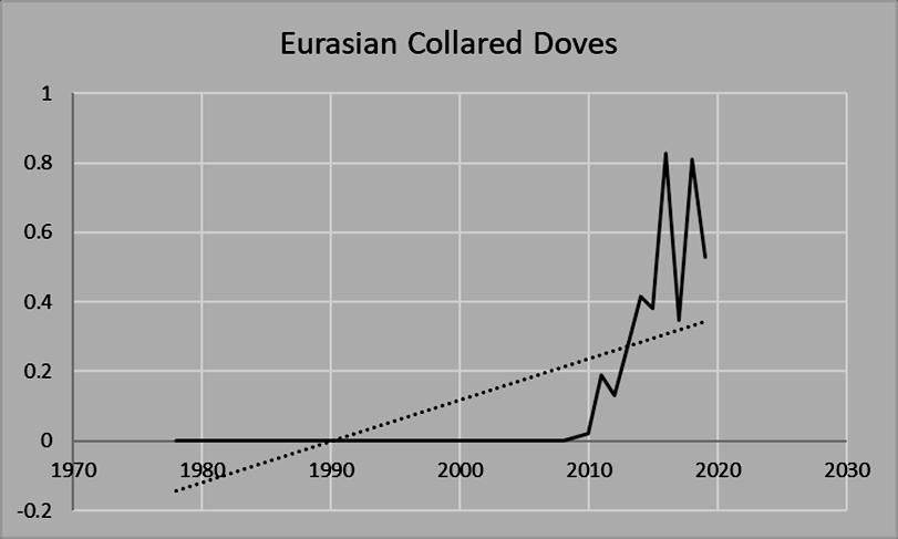
One bird that we are seeing more frequently in the winter is the Eurasian Collared Dove (ECD), Streptopelia decaocto. This bird was first recorded
in Thurston County in 2009, and its numbers have been growing rapidly since. The ECD is an example of a bird that was artificially introduced into the United States by human activity: several dozen were released in the Bahamas in the 1970s, they made it to the mainland in the 1980s, and they have been spreading northward and westward ever since.7 Their success is
19
likely due to two of their attributes: they are very tolerant of humans and they breed multiple times per year. They are not migratory, and hence you can find them here yearround. Like most doves, they are seed-eating ground feeders who can easily be attracted to yards.

ECDs can be distinguished from our other local doves by the black half-necklace that encircles the rear part of their necks, the lack of a shiny green patch on their necks, a lack of any spotting on the body, and possession of a squaredoff tail. Their call consists of four notes and sounds as if they are saying their name: “Eur-As-ian-Dove”, with the third syllable much shorter than the other three.
BALD EAGLES
Bald Eagles, Haliaeetus leucocephalus, were common throughout our country when they were named our national bird in 1782. Unfortunately, their numbers began dropping across the United States as early as the late 1800s; this was caused by a declining availability of the fish that they eat, habitat loss,
Bottom
and intentional culling by farmers who (erroneously) feared that the eagles would harm their livestock. To make matters worse for these birds, the pesticide DDT became available to the
20
Top: The Eurasian Collared Dove. Photograph by Bernardo Alps, Great Backyard Bird Count; used with permission of the National Audubon Society.
: Standardized Sightings of Eurasian Collared Doves on the Olympia Christmas Bird Count, 1978-2019.
general public in 1945: DDT had the unintended consequence of causing Bald Eagles as well as peregrine falcons and other raptors to lay eggs with shells so thin that they crumbled under an incubating bird’s weight. Great damage was done, and in 1963 there were fewer than 500 pairs of Bald Eagles in the entire continental U.S. In good part because of this, DDT was banned in 1972. With the prohibition of this pesticide, Bald Eagle numbers gradually began to increase and in June, 2007 these eagles were removed from the government’s “Endangered and Threatened Species” list.8 In fact, as raptors they belong to one of only two groups of birds (the other being the aforementioned waterfowl) whose national numbers have greatly increased, not decreased, during the past 50 years.9
By 1978, the eagles were essentially non-existent in our region: typically they live here in greater numbers in the winter than in the summer, and, as the graph depicts, from 1978 through 2000 few to none were observed during the winter bird count. However, in the ensuing years, our iconic, beloved Bald Eagles began
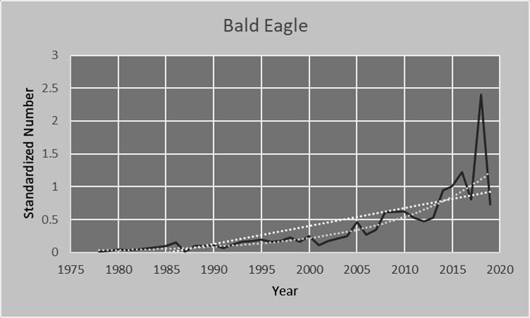
Bottom: Standardized Sightings of Bald Eagles on the Olympia Christmas Bird Count, 1978-2019.
undergoing a renaissance in our region. They are now exponentially increasing in number: whereas a total of 78 Bald Eagles were seen during the count between 1978 and 1987, and 357 from 1993 through 2002, 1,634

21
Top: The Bald Eagle. Photograph by Daniel Joppich, Audubon Photography Awards; used with permission of the National Audubon Society.
were observed during the count in the past ten years. This increase means that, although Bald Eagles accounted for only 10% of our winter raptor observations in 1978 to 1987, during the past ten years they have accounted for a full 49% of them.
Bald Eagle adults are hard to miss: they are the only birds whose body is black/very dark brown and whose head and tail are white. Their feet and large beaks are a deep yellow. Also, they are enormous! Interestingly, the name “bald eagle” does not refer to the fact that with their pale heads they might look “bald” to some; instead, the name is a shortened version of “Piebald Eagle,” their original name. Piebald means black and white, and so is an apt moniker for them. Juvenile Bald Eagles lack the white coloring of their parents and are more easily mistaken for other birds, especially Golden Eagles (which are exceedingly rare in Thurston County during any season) and Turkey Vultures (which are here only in the summer). Juvenile Bald Eagles are a blotchy brown all over with some white mottling on their wings, and they wear this coloration for four years before gaining full adult plumage. Bald Eagles are fish eaters, and so can usually be found near water. They sometimes hunt and other times steal food that other animals and birds have caught.
ANNA’S HUMMINGBIRDS
ty. Anna’s are non-migratory yearround residents, while Rufous Hummingbirds live here only in the summer. Anna’s are assertive, fearless little birds who are readily observed in yards and neighborhoods. They have a striking appearance: the males are grass green with an iridescent rosecolored gorget (bib) and crown. The females are a paler green above, are grayish below, and have a few dark purplish spots on their throats. They are our tiniest winter birds, weighing no more than a nickel. And, like all hummers, they can hover motionless in the air. If you see any orange at all on a local hummer, it is not an Anna’s but a Rufous.
Anna’s Hummingbirds, Calypte anna, are one of the two species of hummingbirds that live in Thurston Coun-
The fact that they can be found here in Washington at all is only because of the food people provide, both in the form of ornamental plantings and nectar feeders. Anna’s Hummingbirds are native to the chaparral of southern California and northern Mexico, and until the 1950s that was the only place that they lived. Now, however, they reside as far north as Canada and as far east as Texas with occasional intrusions into locations as far flung as Florida and Newfoundland.10 In fact, they are now found in more northerly latitudes than any other hummingbird. They are able to do this because of the new food sources people are providing them and also because they are capable of dramatically lowering their body temperatures in cold weather from their normal 107o F to as low as 48o F, thus conserving energy.11
22
As the graph indicates, our Anna’s Hummingbird population did not take off until the 2000s. In the 1980s and 1990s, fewer than one Anna’s was


seen, on average, during the bird count. In the 2000s, that number climbed to about six/year, and in the past ten years counters have seen an average of about 100/year. As more and more new residents join our community, introduce exotic plants, and put out hummingbird feeders, we can anticipate that the Anna’s population will continue to grow.

RED-WINGED BLACKBIRDS
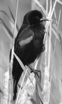
Red-Winged Blackbirds, Agelaius phoeniceus, are among the nation’s most common birds and are found across all 48 contiguous U.S. states and in Alaska; they are in Thurston County yearround. Although they are territorial in the summer during breeding season, in the winter they can form flocks of millions of birds. They are very sexually dimorphic: the males are jet black with red and yellow shoulder epaulets and a black bill, whereas the females can easily be mistaken for a large, stocky, striped brown sparrow. In the summer they congregate mainly in wetlands, while in the winter they are more usually found in fields and grasslands. Their
23
Top left: Male Anna’s Hummingbird. Photograph by Nate Gowan, Great Backyard Bird Count.
Top right: Female Anna’s Hummingbird. Photograph by Mathew Kipper, Audubon Photography Awards.
Both photos used with permission of the National Audubon Society.
Bottom: Standardized Sightings of Anna’s Hummingbirds on the Olympia Christmas Bird Count, 19782019.
diet changes seasonally as well: they are insect eaters during the warm months and seed eaters when it is colder. They feed differently from most other birds, whose beaks close forcefully to crush and grind their food. Red-Winged Blackbirds, in contrast, are “gape feeders” who can forcibly open their beaks to pry food items apart. (Perhaps it is this distinctive feeding style that has allowed them to flourish.)
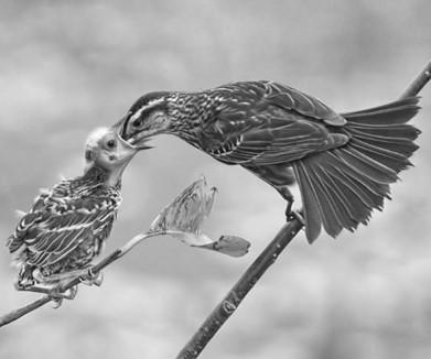
Even though Red-Wingeds are very abundant, their national population has declined by more than 30% during the past 50 years.12 This is likely due to a combination of intentional culling by farmers who are concerned that the birds are feeding on their crops (the birds are easy targets in their massive cold weather roosts), monocultural farming practices, and climate change.13 It is therefore nice to see that this has not been the case locally. Our counters have been sighting twice as many Red-Winged Blackbirds as they did 40 years ago.
Both photos used with permission of the National Audubon Society.
Bottom: Standardized Sightings of Red-Winged Blackbirds on the Olympia Christmas Bird Count, 1978-2019.

Since blackbirds spend much of their time in wetlands, the same conservation efforts that helped waterfowl ap-
pear to have benefited these birds as well, at least in our region.
24
Top left: Male Red-Winged Blackbird. Photograph by Craig McIntyre, Great Backyard Bird Count.
Top right: Female Red-Winged Blackbird and chick. Photograph by Ken Lassman, Audubon Photography Awards.
DECREASING SPECIES
The fact that our overall bird numbers have remained high does not mean that no species have become less common. Let me give two examples of birds that are disappearing from the Olympia-Lacey area.
BARROW’S GOLDENEYES
Barrow’s Goldeneyes, Bucephala islandica, are medium-sized ducks who live primarily in North America’s northwest corner; a small number also live in eastern Canada and Iceland. In the winter, they can be found in Thurston County swimming in protected saltwater coves and bays; they spend their summers in Alaska and Canada, where they breed on shallow freshwater lakes. While here, they feed primarily on mollusks and crustaceans by diving underwater to retrieve them.
Top: Female and male Barrow’s Goldeneyes. Photograph courtesy of Yellowstone National Park Service.

Bottom: Standardized Sightings of Barrow’s Goldeneyes on the Olympia Christmas Bird Count, 19782019.

Male Barrow’s Goldeneyes have brilliant white bellies and chests; their backs, heads, and necks are a glossy black, with a purplish sheen visible on the head. They have bright yellow eyes, and a black bill with a white crescent behind it. They can be distinguished from the more numerous Common Goldeneyes by that white crescent,
since Common Goldeneye males have a white circle instead. Female Barrow’s Goldeneyes have greyish bodies and a brown head. They share the male’s bright yellow eye and have a yellow bill. Female Common Goldeneyes look similar, but have mottled
25
bills and a smaller, rounded head.
They have become much less abundant here than they were 40 years ago. Scientists are not certain exactly what is driving this decline, but it is part of a larger pattern of seabird loss in the Salish Sea. (The waterfowl that are increasing in number live in wetlands rather than more open water.) Exposure to pollutants and, since they build their nests in cavities in large trees, loss of the old-growth forests they depend upon during breeding season may be to blame.14 This trend is especially worrisome because additional large declines are expected to occur due to global warming.
GLAUCOUS-WINGED GULLS
Glaucous-Winged Gulls, Larus glaucescens, are year-round residents which are by far our most common winter gull. Although many people despair at telling one gull from another, Glaucous-Winged Gull adults are quite distinctive and easy to identify: they are our only gulls that have no black whatsoever on wings or tail. While they have pure white heads and necks in the summer and pale brownish heads in the winter, they never have any black anywhere on them. In addition, they have yellow bills and pink legs and feet, and are large for gulls.
Like most gulls, they have voracious appetites and eat almost anything they can find. They hunt by walking along the ground searching for invertebrates or dive and plunge to capture
fish in deeper water. They will eat bird eggs and have even been known to hunt small mammals such as rabbits. They congregate at landfills and will eat carrion and garbage. You would think that such an omnivorous diet would make them very resilient!
However, in the reverse of some of the birds described above, GlaucousWinged Gull numbers are holding steady across the U.S. at large,15 while they are decreasing at a fast rate in our area.
As with the Barrow’s Goldeneyes, this is part of a pattern of bird loss in Puget Sound and the Salish Sea. And, as before, scientists are uncertain as to the cause of these declines. One strong possibility is that the birds are suffering from a decrease in the availability of forage fish (small fish that are eaten by larger animals) such as sandlance and herring.16
CONCLUSION
Where does this leave us? Although Thurston County has in many ways to this point “dodged a bullet” and has retained good bird numbers in total, there is reason to fear for our birds over the next 30 to 60 years. The National Audubon Society projects that in Thurston County 33 winter species are at risk of losing more than half of their range, as are 82 types of birds that summer here.17 Barrow’s Goldeneyes, who have already experienced significant declines, are projected to suffer a net loss of 65% of their summer range and 35% of their winter
26
range. (“Net loss” reflects the summation of total loss of current range pus the addition of new range that becomes available; Barrow’s Goldeneyes are predicted to lose 85% of their current summer range but will gain new range in the Arctic Circle.) The 35% of their winter range projected to be lost includes all of Thurston County. Glaucous-Winged Gulls, the other example
of a bird whose numbers have been locally declining, is actually predicted to gain net range, especially in the summer. However, as the world warms these birds are predicted to shift northwards, and all of their range gain is near the North Pole; it is expected that all or nearly all of our summer Glaucous-Winged habitat will disappear, as will a portion of our suitable winter habitat.


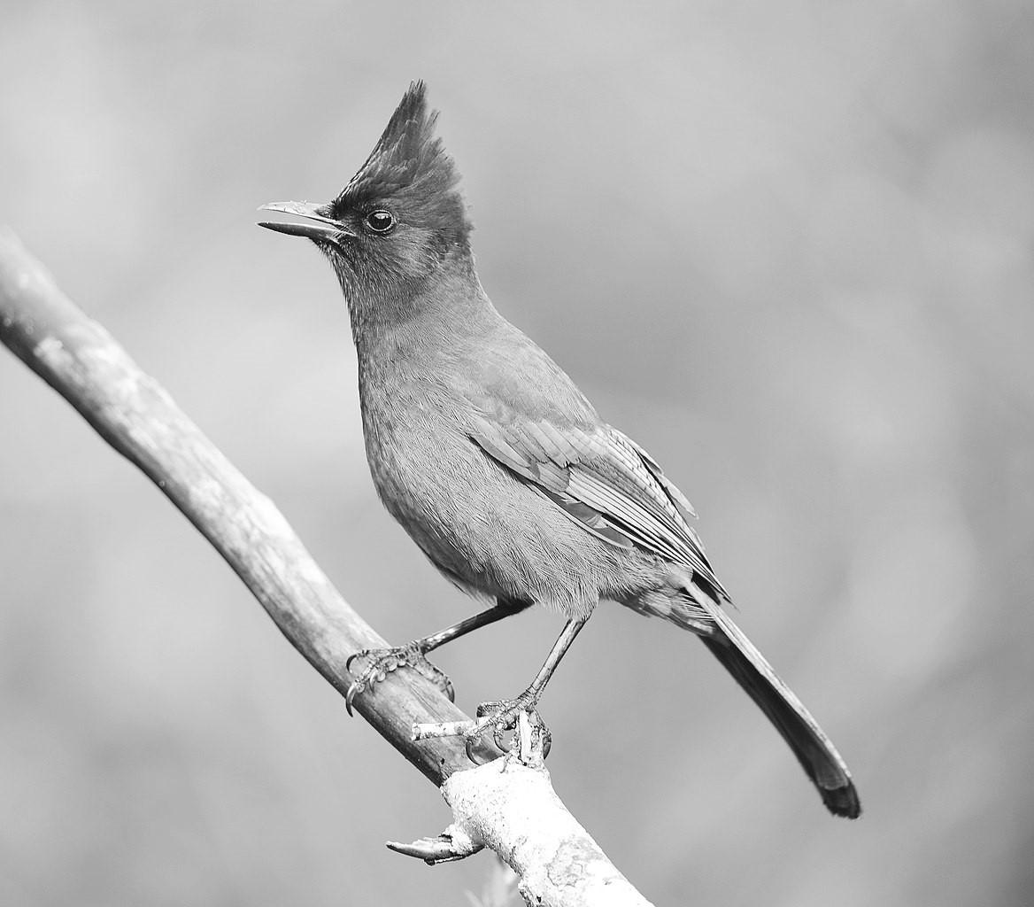
Nor are these the only birds we will lose. Climate change will drive down our local winter numbers of California Quail, American Dippers, Pigeon Guillemots, Steller’s Jays, Western Scrub Jays, Townsend’s Warblers, Bushtits, Golden-Crowned Sparrows, and Evening Grosbeaks as well. Similarly, we are expected to see fewer Northern Pintails, Common Loons, Tree and Violet-Green Swallows, American Goldfinches, RedBreasted Nuthatches, Spotted Towhees, Buffleheads, Rufous Hummingbirds, Western Wood Peewees, Varied Thrushes, Swainson’s Thrushes, Evening Grosbeaks, Dark-Eyed Juncos, and White-Crowned Sparrows.
This is to the detriment of us all, whether you enjoy looking at or listening to birds or not. Because they are
27
Top: Glaucous-Winged Gull. Photograph by Alan Schmierer.
Bottom: Standardized Sightings of Glaucous-Winged Gulls on the Olympia Christmas Bird Count, 19782019.
so mobile and can travel so rapidly, they serve as bellwethers that provide early warnings about environmental disruptions: birds flee unsuitable areas much more quickly than, say, turtles or foxes. In addition, they provide four important services to other organisms.
● They are important pollinators of numerous local plants, including honeysuckle, manzanita, twinberry, flowering current, and madrone.
● Eighty-five percent of our wetland plants rely upon birds for seed dispersal. Birds are so necessary to the seed dispersal process that many plants have evolved seeds that will germinate only after passing through a bird’s digestive system.
● Birds eat enormous quantities of the insects that prey upon plants. In fact, even birds that you think of as seed eaters because they come to feeders largely eat insects during their breeding season.
● Birds and their eggs are food for many other animals.
The entire ecosystem will be disrupted if bird numbers decline. While there is still time to act to reduce our carbon output and to enact policies to retain and enhance natural habitat the window of opportunity for birds is rapidly closing. In Thurston County, we have already seen how large the effects of human intervention can be on our bird populations, for good or for ill: it is time to ensure that we make
changes that will benefit our wildlife.
NOTES
1 “Survival by degrees: 369 species on the brink.” National Audubon Society. https://www.audubon.org/climate/ survivalbydegrees (accessed June 22, 2020).
2 “Cats indoors.” American Bird Conservancy. https://abcbirds.org/pro gram/cats-indoors/cats-and-birds/ (accessed November 6, 2020).
3 K. V. Rosenberg, A. M. Dokter, P. J. Blancher, J. R. Sauer, A. C. Smith, et al, “Decline of the North American avifauna.” Science, October 4, 2019; 366 (6461): 120-124.
4 “History of the Christmas Bird Count.” National Audubon Society. https://www.audubon.org/conser vation/history-christmas-bird-count (accessed August 7, 2020).
5 Christmas Bird Count bibliography, National Audubon Society. https:// www.audubon.org/christmas-birdcount-bibliography (accessed August 10, 2020).
6 Ed Yong, “The quiet disappearance of birds in North America.” The Atlantic, September 19, 2019. https://www.the atlantic.com/science/archive/2019 /09/america-has-lost-quarter-itsbirds-fifty-years/598318/
7 R. Hengeveld, “What to do about the North American invasion by the Col-
28
lared Dove?” Journal of Field Ornithology, Autumn 1993, 64(4):477-489. https://sora.unm.edu/sites/default/ files/journals/jfo/v064n04/p0477p0489.pdf.
8 “Midwest region: Bald and Golden Eagles: Fact sheet: Natural history, ecology and recovery.” U.S. Fish and Wildlife Service. https://www.fws.gov/ midwest/eagle/Nhistory/biologue. html (accessed September 11, 2020).
9 “Bald Eagle removed from list of threatened species.” History.com. https://www.theatlantic.com/science /archive/2019/09/america-has-lostquarter-its-birds-fifty-years/598318/ (accessed September 11, 2020).
10“Pacific Hummingbird found in Newfoundland.” Canadian Broadcasting Corporation. http://www.cbc.canews/ canada/newfoundland-labrador/story /2011/01/24/nl-annas-hummingbird -124.html (accessed September 7, 2020). “Anna’s Hummingbird.” Hummingbird Central. https://www. hummingbirdcentral.com/annashummingbird.htm (accessed September 7, 2020).
11 “Anna’s Hummingbirds.” Pacific Grove Museum of Natural History. https://www.pgmuseum.org/annas hummingbird (accessed September 10, 2020).
12 “Red-winged blackbird: Life history.” All About Birds. https://www.allabout birds.org/guide/Red-winged_Black bird/lifehistory (accessed September 9, 2020).
13 “Red-Winged Blackbirds.” American Bird Conservancy. https://abc birds.org/bird/red-winged-blackbird (accessed September 9, 2020). P. J. Weatherhead, “Long-term decline in a red-winged blackbird population: ecological causes and sexual selection consequences.” Proceedings. Biological sciences, November 7, 2005, 272 (1578): 2313–2317. https://doi.org/ 10.1098/rspb.2005.3211 (accessed September 9, 2020).
14 Archived 2020 topic: “Barrow’s Goldeneye (Bucephala islandica): Revise global status?” Bird Life International. https://globally-threatenedbird-forums.birdlife.org/2020/06/ barrows-goldeneye-bucephala-island ica-revise-global-status/ (accessed September 8, 2020).
15 “Glaucous-Winged Gulls: Life History.” All About Birds. https://www.all aboutbirds.org/guide/Glaucouswinged_Gull/lifehistory (accessed September 10, 2020).
16 “Long Live the Kings. Forage fish in the Salish Sea.” https://lltk.org/ forage-fish-in-the-salish-sea/ (accessed September 10, 2020).
17“Vulnerable birds in Thurston County.” National Audubon Society. https://www.audubon.org/climate/ survivalbydegrees/county?zipCode =98516 (accessed June 22, 2020).
29
Kim Gale Adelson was a college professor for more than 30 years. She has a master’s degree in evolutionary biology and a Ph.D. in psychology. She is on the Board of the Black Hills Audubon Society, and frequently gives talks about local birds, their evolution, and the stresses that climate change will bring them.
Other familiar Thurston County birds face a decrease in population due to climate change. These include:


30
Top: American Dipper. Photograph by KaleighAlysse, via Wikimedia Commons.
Center: Evening Grosbeak. Photograph courtesy of Oregon Department of Fish & Wildlife.
Bottom: Steller’s Jay. Photograph by VJAnderson, via Wikimedia Commons.
THE CHAMBERS BLACK HEART CHERRY TREE: A NORTHWEST ICON
Deborah Jane Ross
One October evening in the 1850s, early American settler Tyrus Himes and his family stopped at the homestead of fellow Thurston County settlers David and Elizabeth Chambers, who had recently built their home on the edge of the prairie bearing their family name, Chambers Prairie. Elizabeth treated the Himes family to cherry preserves, which she had made from the produce of a young tree growing near the home. Over seventy years later, on July 19, 1926, Tyrus’s son, George Himes, plucked cherries from the same tree, nearly bookending the lifespan of the remarkable specimen known as the Chambers Black Heart Cherry Tree.1
The tree’s story begins in the mid1840s, with orchardist Henderson Luelling.2 Luelling moved from Salem, Indiana to Salem, Iowa in 1836, and planted an orchard that included 35 varieties of fruit trees. Luelling was a Quaker and abolitionist, and his home in Iowa, once a stop on the Underground Railroad, is now a museum.3 In 1848, he continued his westward journey to Oregon, bringing several hundred root grafts from his orchard, nestled in boxes filled with soil mixed with pulverized charcoal.4 A 1926 article about Luelling claimed that he sur-
vived the arduous journey unmolested by Native Americans because they revered the saplings as representatives of the Great Spirit.5 During Luelling’s long journey over the Oregon Trail, the trees began to grow—some of them

31
Henderson Luelling, pioneer orchardist. Photograph from Joseph Gaston, Centennial History of Oregon, Volume 1. Chicago: S. J. Clarke Publishing Company, 1912, following page 330.
had reached a height of three feet by the time of his arrival in Milwaukie, Oregon Territory.6 With this “Traveling Nursery,” he laid the foundation for the Pacific Northwest fruit industry.7 He sold many of the trees to the United States government for $1.50 per tree, but also began selling them to settlers who were streaming to the West along the Oregon Trail, including David Chambers.8

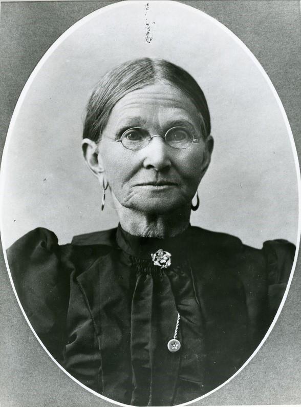
David and Elizabeth Harrison Chambers and the extended Chambers family, originally from Missouri, were among the earliest American arrivals to what would become Washington Territory (but was then part of Oregon Territory). They set out from Missouri in 1845, along with David’s parents and several siblings. After a stay south of the Columbia River, they reached our area in 1848. The extended family settled on several claims in what would become Thurston and Pierce Counties; David and Elizabeth ultimately settled on their own homestead in the fall of 1850, filing a 640-acre claim under the Donation Land Claim

32
Above: Advertisement for Luelling’s nursery from Olympia’s Pioneer and Democrat newspaper, September 23, 1854.
Below: David and Elizabeth Harrison Chambers. Photographs by A. D. Rogers, State Library Photograph Collection, 1851-1990, Washington State Archives, Digital Archives, http://www.digitalarchives .wa.gov (accessed November 18, 2020).
Act.9 By then the couple had three children. They lived first in a log house, but a frame house was completed in 1853, a few days before their daughter Mary was born.10
In the fall of 1853, David Chambers traveled to Fort Vancouver on legal business and stopped at the nearby Luelling orchard. He carried home fifteen apple, four pear, four plum and four cherry trees on horseback.11 The family planted these in the spring, and Elizabeth Chambers recalled in her memoir that every one of them grew. The main body of the orchard was located to the southwest of the home, extending towards the southeastern lobe of Chambers Lake in what is now Lacey. But one of the trees, a Black

Heart cherry tree,12 was planted just outside the south side of the Chambers home.13
According to online tree catalogs and other resources, the Black Heart cherry was once a popular variety of tree, used for preserves, pies, jams, jellies, and toppings. Many people, including the author, find them tasty right off the tree as well. These cherries are not commonly found in grocery stores or farmer’s markets due to their size and shipping challenges. They can still be found in heirloom gardens but are not readily available from nurseries.14 Their typical lifespan is fifteen to 30 years, although some are known to live longer. Their average maximum height is 30 feet, with an average max-
33
Edward Lange painting of Chambers homestead, circa 1890. Image courtesy of Washington State Historical Society.
imum span of 30 feet. The subject of this story was different it was no ordinary specimen.
As the farm grew, so did the Chambers Cherry Tree.15 The Himes family visit to the homestead, and George’s sampling of Elizabeth’s cherry preserves, probably took place around 1855, when the tree was just a sapling. By 1895, according to Himes, it was bearing 40 bushels of cherries.16

The size, longevity, and productivity of the tree was starting to attract widespread attention. In 1897, the Daily Olympian drew readers’ attention to an article in an Oregon publication, the Pacific Farmer, that described the
tree as “a monster, having a body 3 ½ feet in diameter, and a limb spread of 60 feet in diameter.”17 At age 47 or so, the tree was already considered old for a cherry tree. In the same year, Mrs. Walter (Lottie) Chambers was visiting the homestead when she fell from the tree, dislocating her shoulder.18
In August 1899, a brief mention in the Morning Olympian claimed that “the biggest cherry tree in the northwest is on the old homestead of David Chambers, east of this city. It was planted in 1849 [sic] by Mr. Chambers, who brought the twig over from Oregon. It spreads 60 feet across the top, and the trunk measures 8 feet six inches in circumference.”19
34
C1943.2x.31.2, courtesy of the Washington State Historical Society.
In her 1910 memoir, Elizabeth Chambers calculated the tree’s size at “eight feet around the body and 60 feet from tip of limb to tip of limb.”20 In 1912, a photograph of the tree was accompanied by a notation that its span was sixty feet and its circumference 8 feet 4 inches. The photograph shows members of the extended Chambers family posing underneath the tree, with at least six other figures hidden among its branches.
In 1914, Walter Chambers, the young-
est child of David and Elizabeth Chambers, leased part of the homestead claim, including the family home, to the Olympia Golf and Country Club, which purchased the property outright in 1917.21 The Chambers home became the clubhouse, and golfers teed off in front of the tree, which was still thriving and bearing fruit. A 1917 article announcing the dedication of the club observed that the grounds still contained “immense maples and cherry trees.”22 In 1919, another article quoted Portland’s Morning
35
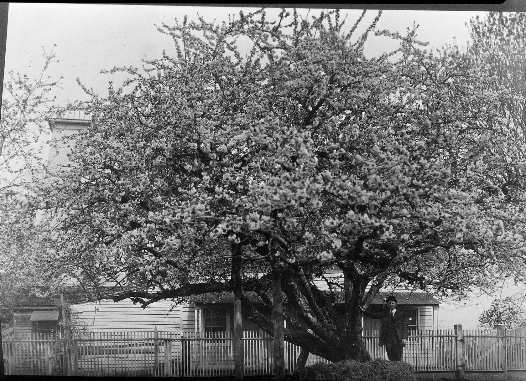
Andsworth Chambers with Chambers Cherry Tree. Vibert Jeffers photograph circa 1925, Susan Parish Collection, Washington State Archives.
Oregonian about the tree, noting that it was likely the oldest cherry tree in the northwest. It also noted that the tree was still producing cherries.23 George Himes stated that in 1920 it bore 1,200 pounds of cherries.24
By the early 1920s, the tree was starting to show its age and the burden of its immense size. A photograph of Andsworth Chambers (son of David and Elizabeth) shows him standing next to the tree, then in full blossom. The image shows that a sturdy scaffold has been placed along one of the huge horizontal limbs to prop it up. Even so, a 1923 article celebrated it as the “patriarch of the fruit industry” and noted that it was still bearing fruit.25
In 1925, when the Olympia Golf and Country Club moved to its current location off Cooper Point Road, it sold the property to the Mountain View Golf Course. The Chambers homestead continued as the clubhouse, and the tree was still bearing fruit.26
In late 1926, extensive surgery was performed on the tree to try to lighten the burden associated with its immense size and age. The timber removed was sent by Mountain View Golf Course owner G. H. Smith to Van’s Hardwood Mills, to be crafted into furniture and gavels.27 George
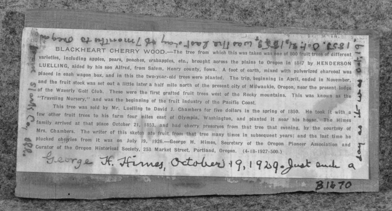
Top: Slab from Chambers Cherry Tree donated to Iowa Historical Memorial and Art Department. Image courtesy of Iowa Historical Society.
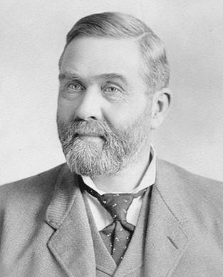
Bottom: George Himes. Photograph 2014.0.312, courtesy of Washington State Historical Society.
36
Himes, then the Secretary of the Oregon Pioneer Association, also sent small slabs of the tree to the Iowa Historical Memorial and Art Department,28 in recognition of Henderson Luelling’s Iowa connection, and to the Oregon Historical Society. Affixed to the slabs is a note that relates the tree’s history, and Himes’s long-ago visit to the Chambers homestead to taste Elizabeth’s cherry preserves. It is possible that Himes also sent a slab to the Washington State Historical Society, but if so, the item has not yet been catalogued.
A lengthy article about Henderson Luelling, written in 1929, noted that the author visited the Chambers homestead in 1928 and the tree was still in existence.29 But the end was near. A photograph in the Lacey Museum collection shows a young golfer, Mildred Kearney, standing next to the tree in about 1929. Another page of the album shows a group of women golfers teeing off from the clubhouse’s south lawn. The tree had been chopped down, but its huge stump is visible behind the women. Extending from the stump are two leafy shoots, valiantly but vainly striving for life.

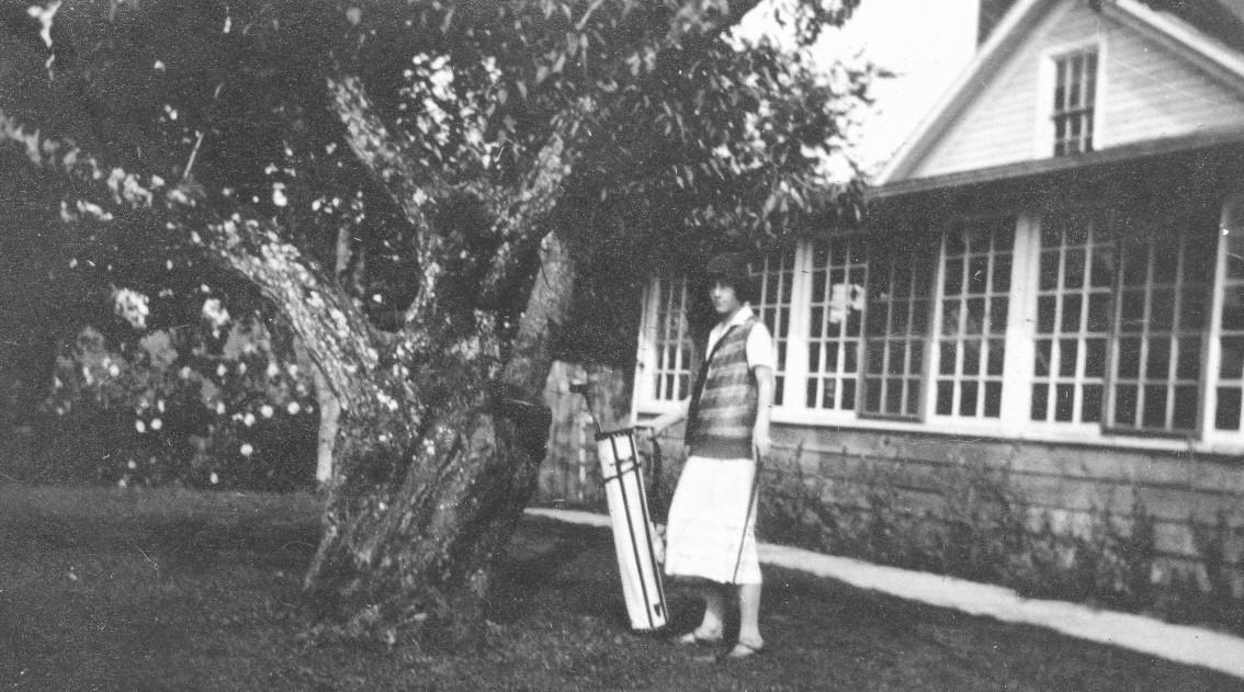
The tree was not forgotten. Its descendants, or those from other mem-
bers of the Chambers orchard, had populated the golf course. A 1939 article about the Chambers family and homestead noted: “Many is the Olympia golfer who has halted his game briefly to eat cherries from Chambers’
37
Top: Mildred Kearney standing by Chambers Cherry Tree., circa 1929.
Bottom: Golfers at Mountain View Golf Club, with cherry tree stump in the right background.
Both photographs courtesy of Kearney Collection, Lacey Museum.
Top: Panorama City clubhouse, formerly the Chambers homestead, as it appeared in the early 1960s with cherry tree stump in center of photo. Photograph courtesy of Panorama Archives, Sprengel Collection.

Bottom: A cherry tree is shown on the Panorama campus, 1963. This tree is likely a descendant of the original Chambers Cherry Tree. Photograph copyright Daily Olympian, used by permission.
trees without thought or knowledge of what the fruit which came to him so easily cost the pioneer in labor and care.”30 A 1953 advertisement for the Mountain View Golf Course noted that the tree’s “stump still stands by the clubhouse.”31
In 1960, Lacey developer Morris Loveless acquired the golf course property, and created Panorama City, a retirement community (now Panorama). In Panorama City’s early years, the Chambers homestead, which was located a few hundred yards inside the main entrance off SleaterKinney Road, continued to serve as the residents’ clubhouse.
A photograph from the early 1960s shows a gentle mound on the Chambers Cherry Tree site, on the south side of the clubhouse, with a large shrub growing on it.32 In 1968 the Chambers homestead was razed to make way for the Chalet apartment building. By then all traces of the tree had disappeared from the site.
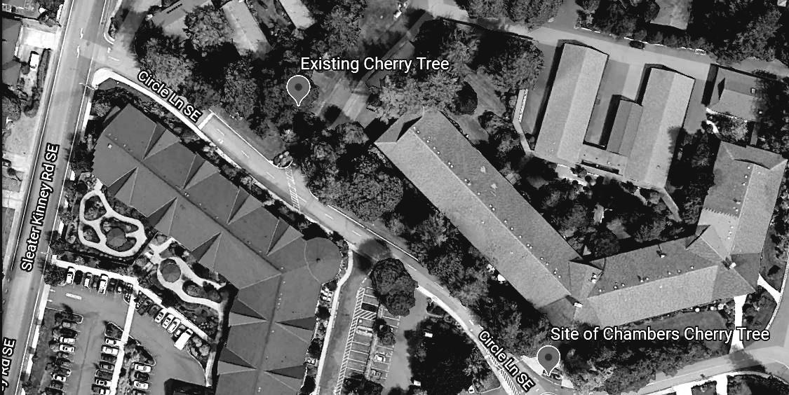
The tree’s legacy lives on in its progeny. In a photograph from the early 1960s, a cherry tree growing near Panorama City’s main entrance can be seen, already several feet high. This tree is around 400 feet from the Chambers Cherry Tree’s location. It still stands in 2020, immense, gnarled and contorted, and bears a

38
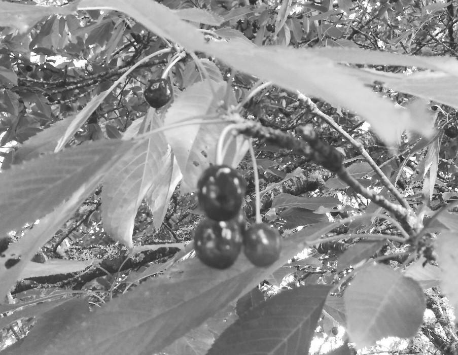
striking resemblance to the Chambers Cherry Tree.33 In late spring it displays a breathtaking explosion of blossoms, and in early summer it produces an abundant crop of Black Heart cherries. Evidence points to this being a descendant of the majestic Chambers Black Heart Cherry Tree.
2 Sometimes spelled Lewelling.
3 Henderson Lewelling House, https:// www.nps.gov/nr/travelunderground/ ia3.htm (accessed October 10, 2020). The Underground Railroad was a network of safe houses that slaves used to escape to free states in the north before and during the Civil War.
4 Himes note.
1 George Himes (son of Tyrus), note submitted with donated slab of wood, Accession Number B 1548, State Historical Society of Iowa. Himes’s dates are off by two or three years: he states that the tree was purchased in 1850 and preserves enjoyed in 1853, whereas the tree was not planted until fall 1853.
5 “Cherry Tree, Brought Across Plains in 1846, Still Standing on Grounds Of Mountain View Country Club,” Morning Olympian, November 14, 1926, page 2.
6 “Iowa Nurseryman Introduced Fruit Trees Into Oregon,” The Annals of Iowa, Volume 16 Number 2, Fall 1927, page 145.
39
NOTES
Location of original Chambers Cherry Tree near current entrance to Chalet apartment complex, and the existing cherry tree. Image from Google Earth.
7 “The Lewelling FamilyPioneers,” Iowa Journal of History, Volume 27 October 1929, No. 4, http://iagen web.org/history/journal/ oct1929.htm (accessed October 10, 2020).
8 Luelling’s later life was a study in contrasts. After leaving Oregon, he moved to California and is honored as one of the founders of the California fruit industry. Later, he abandoned his fourth wife, moved to Honduras, and started a commune devoted to Utopian ideals that included scandalous support for “free love.” With the commune a failure, he returned to California but never regained the success he had experienced earlier. “The Lewelling Family-Pioneers.”
9 The Donation Land Claim Act of 1850 was a federal program intended to promote homestead settlements in the Oregon Territory. It entitled married couples to claim 640 acres of designated areas free of charge (one half to be owned by each spouse).
10 Elizabeth Harrison Chambers, manuscript, “Incidents in the Life of Elizabeth Harrison Chambers,” transcribed in Berta Kasmar, Panorama History: The First Fifty Years, 2011, page 13.
11 Chambers in Kasmar, page 13.
12 “The Lewelling Family-Pioneers,” referring to the Chambers Cherry Tree, says that its pit was planted in 1845 and the resulting seedling grafted onto a Black Tartarian scion. The terms Black Heart and Black Tartarian seem to be roughly equivalent and refer to a variety first introduced from Russia in the 1700s. “Prunus Cultivar: Black Tartarian.” https://fps.ucdavis

40
Existing Black Heart cherry tree on Panorama campus. Photograph by author.
.edu/treedetails.cfm?v=288 (accessed November 5, 2020).
13 The tree is not visible in the Lange painting because it was located on the far side of the house from the main (north) entrance shown in the painting.
14 “Cherry varieties.” https://www. Albemarleciderworks.com/orchard/ fruit/cherries (accessed October 10, 2020).
15 The Chambers homestead thrived as a diversified farm, producing not only fruit from the orchard, but also supplying a successful source of meat for the Olympia-based butcher shop run by sons Andsworth and Walter Chambers. Andsworth later became mayor of Olympia and was the builder
of the Chambers Block at Fourth and Main (now Capitol Way).
16 “The Lewelling Family-Pioneers,” quoting George Himes. Annals, page 144.
17 Untitled, Daily Olympian, June 25, 1897, page 2.
18 “Brevities of the Day,” Daily Olympian, July 12, 1897.
19 “News of the City in Brief,” Morning Olympian, August 13, 1899.
20 Chambers in Kasmar, page 13.
21 “Early History of Olympia Country and Golf Club, Olympia, WA,” http:// nwhickoryplayers.org/wp-content/ uploads/2015/12/Olympia-Countryand-Golf-Club-History.pdf (accessed
Both photographs by author.
41
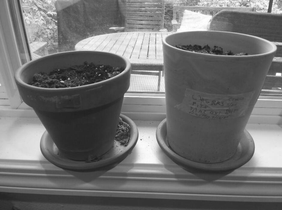
Left: Ripe cherries on the existing Black Heart cherry tree.
Right: Ten cherry pits from the existing Black Heart cherry tree now sit in two pots on the author’s windowsill.
November 5, 2020). The club later purchased the land in 1917. Thurston County Auditor, Deed of Record, Thurston County, dated May 21, 1917.
22 Untitled, Morning Olympian, July 17, 1917.
23 “Olympia Boasts Old Cherry Tree,” Morning Olympian, May 12, 1919, page 4.
24 “The Lewelling Family-Pioneers.”
25 “Oldest Fruit Tree In State Located Close to Olympia,” Morning Olympian, April 17, 1923, page 1. An apple tree known as the Old Apple Tree located in Vancouver, Washington, at the site of Fort Vancouver, was also alleged to be the oldest fruit tree in the Pacific Northwest, planted in the 1820s. It finally succumbed in the summer of 2020. “Heritage Trees – The Old Apple Tree.” https://www.cityofvancouver .us/publicworks/page/heritage-treesold-apple-tree (accessed October 16, 2020). A common life expectancy for apple trees is 100 years, compared with fifteen to 30 years for a cherry tree.
26 “Early History of Olympia Country and Golf Club.” George Himes says that he plucked cherries from the tree on July 19, 1926. Himes note.
27 “Famous Old Tree Still Standing Near City, First Planted in 1850 by Pioneer Chambers,” Morning Olympian, November 11, 1926, page C6, and “Cherry Tree, Brought Across Plains in 1846, Still Standing on Grounds Of
Mountain View Country Club,” Morning Olympian, November 14, 1926, page 2. A gavel in the collection of the Washington State Historical Society, once belonging to Olympia Mayor P.H. Carlyon, may be among those crafted from the tree’s limbs. Catalog item 2016.62.12.
28 Annals, page 144.
29 “The Lewelling Family-Pioneers.”
30 Untitled, Daily Olympian, May 15, 1939, page 8.
31 Untitled, Daily Olympian, May 27, 1953, page C6.
32 Photograph, Chambers home (Panorama City clubhouse), circa 1965, Panorama Archives, Sprengel Collection, box 2.
33 Some references erroneously state that this tree is in fact the Chambers Cherry Tree itself. Tree and Shrub Guide, Lacey, WA: Panorama, 2014, page 4.
Deborah Ross is the research coordinator and webmaster for the Olympia Historical Society and Bigelow House Museum, and the Resident Archivist for the Panorama retirement community. She produces the weekly Looking Back feature for the Sunday Olympian and has written two fact-based historical novels based on Thurston County’s Schneider family. She lives at Panorama with her husband Brian Hovis.
42
WATER, WOODS & PRAIRIES: A THURSTON COUNTY HISTORY BOOK
Ann Olson
If the recently released history book, Thurston County: Water, Woods & Prairies, were a theatrical production, the billing would note “Box Office Hit!” As it is, this new book is almost literally flying out the door by popular demand. Together with the Thurston County Board of Commissioners and the Thurston County Historic Commission, the Olympia Historical Society & Bigelow House Museum and other local heritage organizations and retailers are making this significant and unique work about Thurston County history available to the public.
Water, Woods & Prairies is at once a beautiful coffee table volume as well as an extensively footnoted and indexed resource for history buffs, genealogists, long-time residents, and newcomers alike. The book covers the people, places and happenings from before the county’s beginnings up to current times. The book is laid out in a refreshing manner, making it easy to thumb through the pages and enjoy the more than 250 photos, original documents, twelve maps, and 25 sidebars. Or stop a moment, or longer, to read thoroughly researched essays on
Native Americans, maritime explorers, loggers, early settlers, farmers, and the towns and communities of Washington’s capital county, as well as the story of the state capital itself. A rich heritage indeed!

43
The book is written by nine wellestablished local historians: Gerry Alexander, Drew Crooks, Jennifer Crooks, Sandra Crowell, the late Les Eldridge, Dr. James Hannum, Karen Johnson, Shanna Stevenson, and Don Trosper. Others contributing to the work are co-editors Sandra Crowell and Shirley Stirling, copy editor Chris Colton, and former director of the Washington State Historical Museum and Tumwater resident, David Nicandri, who supplied an introduction. “Water, Woods & Prairies represents years of volunteer effort and local knowledge,” co-editor Crowell said.
Rave reviews for the book are already in and everyone I have talked with has said how much they are enjoying the book or words such as, “I love it!” After receiving a copy of the volume, Charlene Krise, Squaxin Island tribal leader, commented, “Everything about your book is beautiful from the essays, to the photographs, texture of the hardcover and of each page.” It is a beautiful book and one that is truly a joy to experience from beginning to end, cover to cover, and all the pages in between.
With the publication of Water, Woods & Prairies, the goal of the Thurston County Historic Commission is to promote an interest in Thurston County history. The books are $30 for softbound and $40 for hardbound, plus sales tax, and mailing costs in some cases. This book makes a wonderful gift!
For complete and updated information on how to purchase copies of Thurston County: Water, Woods & Prairies, contact https://olympiahistory.org or other county heritage group; copies may also be available at local bookstores. Purchasing a book from one of the heritage organizations supports their particular projects and programs, while purchases from local retailers support our small businesses.
Ann Olson is a board member with the Olympia Historical Society & Bigelow House Museum; Daughters of the Pioneers of Washington local chapter president and state association 2nd vice president; Olympia Genealogical Society co-founder, past president and current board member; board member/ officer of the Sacajawea Chapter, Daughters of the American Revolution; Governor’s Mansion Foundation History Committee chair; and member of other heritage, lineage, and community service groups. A 17-year capital campus tour guide and Governor’s Mansion docent, Ann co-chaired the Mansion Centennial and served on committees for Washington’s 125th Birthday, Temple of Justice Centennial, and 400th Anniversary of the Magna Carta. In her former life she served in Governor Gardner’s policy unit and task force on education and is a former state PTA president and national PTA vice president. Ann is a native Washingtonian and 50-year Olympia resident.
44
The photo on the back cover was taken on May 6, 1950 during the Centennial Parade of Progress in Olympia. It was the culmination of a week-long centennial celebration in the city. A record crowd of 75,000 people (three times the city’s population) thronged city streets to watch a two-hour parade featuring marching bands, floats, and community organizations.
The location of the photo was on Cherry Street between State and Fourth Avenues. The view is looking northeast.

Unfortunately, the women or the group they belonged to are not identified. If you have any information about these women, please contact the Journal editor.
Note: the eagle on the roof of the building is just part of a sign.
To view a video of the parade, visit https://www.facebook.com/WaState Archives/videos/olympias-centennialparade-of-progress-may-61950/ 291159695216017/.
To read a description of Olympia in 1950, visit https://olympiahistory.org/ wp-content/uploads/2020/08/1950Grand-Parade-of-Progress.pdf. Narrative
Many thanks to Ben Helle of the Washington State Archives-Olympia office for these photos and description.
Photograph on back cover was taken by Merle Junk, Susan Parish Photograph Collection, Washington State Archives.
Photograph on this page was taken in 2019 by Benjamin Helle, Archives and Record Management Division, Washington State Archives-Olympia.
WHO/WHAT/WHERE IS IT?
Is courtesy of Lynn Erickson.
Who are these lovely ladies, dressed for a special occasion? See inside back cover for more information.

WHO/WHAT/WHERE IS IT?


 Figure 15. Proposed Drainage Infrastructure, Old Capitol Building, LPD Assessment Drawings, Appendix D, Sheet 2. Peter Meijer Architect, PC, April 11, 2014.


