In its simplest definition, development is the process by which something grows or changes and becomes more advanced. As professional consultants, growth and change are part of our core values. Whether we’re expanding a practice area or deepening our expertise, we’re continuously evolving.
In this issue, we examine funding options to help your municipality develop underutilized brownfield sites to advance revitalization in your community. These sites, along with closed and capped landfills, may also be candidates for solar energy arrays. Energy transition and electrification present opportunities for municipalities, and our team can help assess the grid infrastructure that will be required of municipal utilities.
Across all communities, strategic development opportunities must be discovered and funded. GIS technology can take your project from concept to development by using data-driven decision-making.
We always share a little bit about LaBella’s own evolution, and in this issue we’re excited to introduce our Multi-Modal Planning and Design Group led by Douglas Teator, PE. With this group’s expertise and added service offerings, your community’s development can set new standards for accessibility and connectivity.
With each issue of In Office we present our experience, our expertise, and our forecasting on the topics and trends that affect municipal projects. Let us know if there’s a topic we can explore for you by contacting us at inoffice@labellapc.com.

In March 2024, the City of Elmira and the Town of Mohawk Fire District were awarded statewide APWA New York Chapter Public Works Project of the Year awards!
The City of Elmira won in the Transportation < $5 million category for its Lake Street Pedestrian and Bicycle Bridge project (pictured above), and the Town of Mohawk Fire District won in the Structures $5–$25 million category for its New Fire Station project.
LaBella is honored to have been recognized for our roles on these exciting projects! Scan the QR code below to learn more.
By Norabelle Greenberger, AICP | Senior Planner
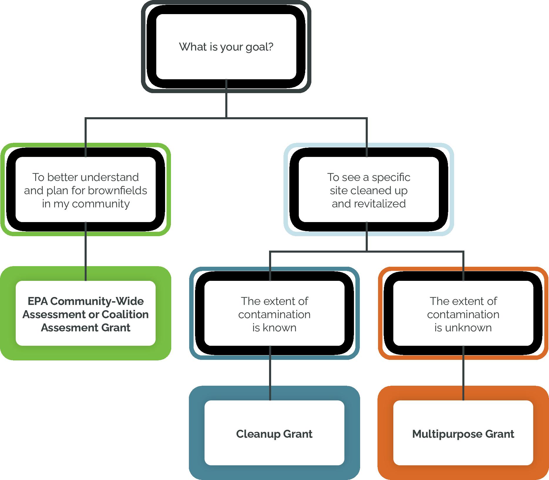
Do you have a site that you would like to see redeveloped? Would you like more commercial development in your downtown corridor? Do you have a need for more housing? Are the known or unknown costs of development an impediment to seeing these visions realized? If your answer to any of those questions is yes, then brownfield funding can be your ticket to help remove redevelopment barriers and set the stage for revitalization.
Brownfield sites—properties where the presence or potential presence of hazardous substances, pollutants, or contaminants complicates their expansion, redevelopment, or reuse—often evoke negative connotations. The term itself can conjure images of dilapidation and risk, deterring communities
from engaging with these sites or seeking out funding for their redevelopment. However, such apprehension overlooks the transformative potential of brownfield funding, particularly through programs administered by the U.S. Environmental Protection Agency (EPA) and state-level initiatives. By leveraging these resources, communities can turn perceived liabilities into thriving assets, fostering economic growth, environmental cleanup, and social rejuvenation.
The term “brownfield” is frequently misunderstood, leading to a pervasive stigma. This stigma is fueled by the fear of contamination, potential
health risks, and the assumed insurmountable costs associated with remediation. Communities may worry about liability issues, prolonged project timelines, and the technical complexities of environmental cleanup. These fears can prevent local governments and stakeholders from pursuing redevelopment opportunities, leaving potentially valuable land unused and blighted areas unimproved.
However, this hesitation ignores the significant advancements in environmental science and policy that have made brownfield redevelopment more manageable and economically viable than ever before. The EPA’s Brownfields Program, established in 1995, has been instrumental
continued on page 4
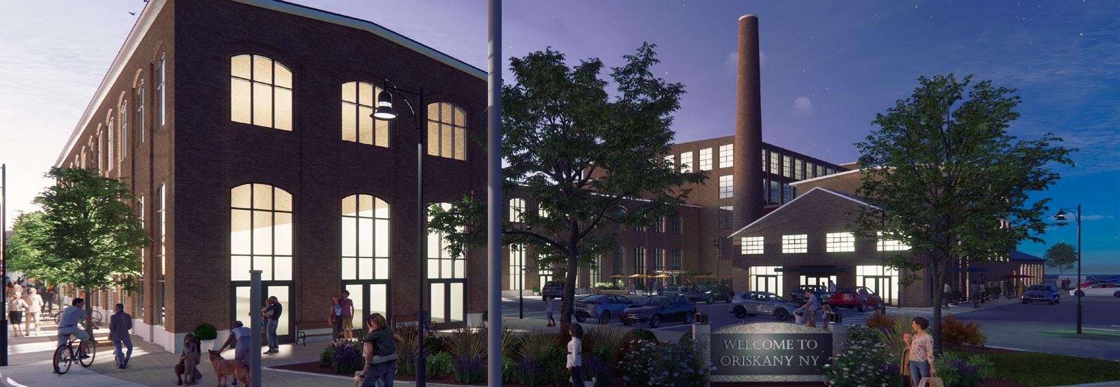
In 2022, LaBella worked with MV Edge to conduct environmental and planning work at priority brownfield sites in Oneida County, including the Waterbury Felt Site in the Village of Oriskany. Using data from the environmental assessment, a market analysis, and community feedback, LaBella, MV Edge, the Village, and the property owner came up with a redevelopment vision. The result? Community support, rezoning to facilitate the development, and a $2 million Restore NY grant to begin the first phase of the project’s development. The project was funded through an EPA CommunityWide Assessment grant.
Brownfields, continued from page 3
in debunking these myths by providing the necessary financial and technical support to tackle these challenges head-on.
To effectively utilize brownfield funding, communities must first overcome the negative associations with the term. This can be achieved through education and advocacy, highlighting successful redevelopment projects and the comprehensive support available through federal and state programs.
Brownfield funding is a powerful tool for communities looking to revitalize underutilized or abandoned properties. The EPA’s Brownfields Program offers grants, revolving loan funds, and technical assistance to assess, clean up, and plan for the reuse of these sites. Each program is designed to address different aspects of brownfield redevelopment, from assessment
and cleanup to community engagement and job training, ensuring comprehensive support for revitalizing contaminated properties.
State-level programs complement federal efforts, often providing additional resources and incentives tailored to local needs. Some examples include New York State’s Department of State Brownfield Opportunity Area (BOA) Program, which funds county-wide brownfield inventories, neighborhood-level revitalization planning, Phase II
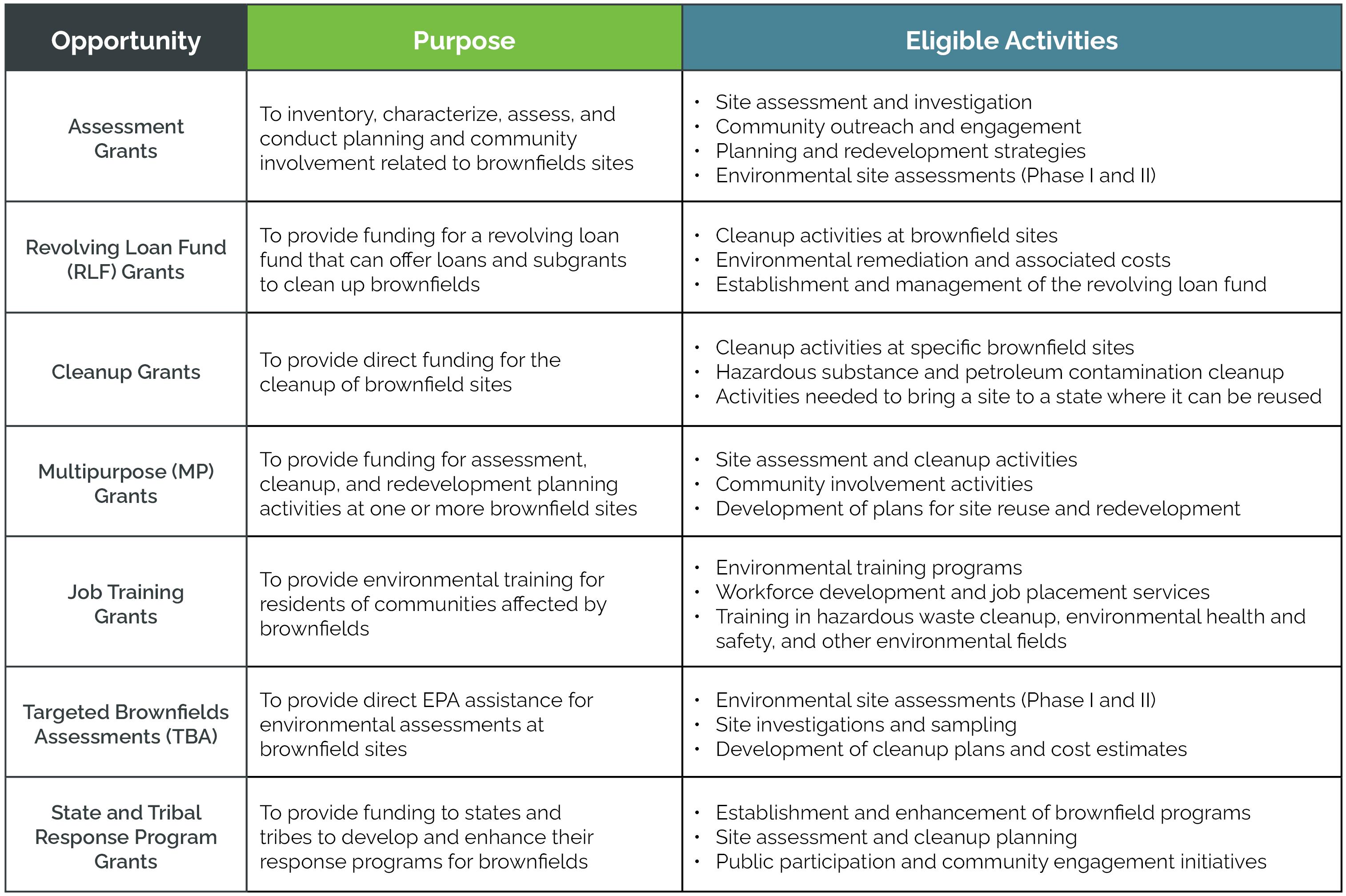
Environmental Site Assessments, and a range of pre-development activities, including engineering, marketing, zoning updates, and more. The Virginia Brownfields Restoration and Economic Redevelopment Assistance Fund (VBAF) provides grants or loans to local governments to promote the restoration and redevelopment of brownfield sites and to address environmental problems or obstacles to reuse so these sites can be effectively marketed to new economic development prospects. This includes both a Site Remediation Grant program and a Site Assessment and Planning Grant program. In 2023, Tennessee launched its Brownfield Redevelopment Area Grant (BRAG), a statewide brownfield grant program for identification, investigation, and remediation to encourage the redevelopment of brownfields.
The next round of EPA Multipurpose, Assessment, and Cleanup funding is expected to open in September, with grants due 60 days later. A successful grant application requires thought, strategy, and vision. Defining your project and your goals early is critical to determining the appropriate funding strategy.
As you define your project, LaBella’s expert brownfield team can help you prepare and then implement a brownfield action plan that meets your goals and addresses:
• site assessment requirements,
• reuse planning,
• the most appropriate and flexible funding strategy,
• site ownership transfer approaches,
• legal liability protections and defenses,
• cost-effective remedial options, and
• viable and sustainable site redevelopment.
It is important to consider these action plan components during the preparation of brownfield grant applications.
Brownfield funding represents a tremendous opportunity for communities to overcome the challenges associated with contaminated and underutilized sites.
By embracing the resources provided by the EPA and statelevel programs, communities can unlock the potential for economic growth, environmental restoration, and social revitalization.
Dispelling the negative connotations associated with brownfields and fostering a proactive, informed approach to redevelopment can transform these sites from stigmatized liabilities into thriving community assets.
By Jared Pristach, PE | Environmental Engineer
Human activities have always had a major impact on their surroundings, and since the Industrial Revolution, modern development has resulted in environmental contamination and increased greenhouse gas emissions. Despite ongoing efforts to remediate these issues and curb emissions, many areas in the United States still bear the scars of past environmental harm. Evidence of this damage can be seen in landfills, Superfund sites, and brownfields. As energy consumption increases, solar energy development has surged due to advancements in photovoltaic technology. This shift raises the question: can we convert these contaminated sites into opportunities for renewable energy production, thus addressing both environmental rehabilitation and sustainable energy demands?
Landfills and contaminated sites have become commonplace reminders of human development. If you’re not familiar with these kinds of sites, here’s a quick introduction:
• Landfill: A site for disposing of various wastes, including municipal solid waste (MSW), construction and demolition
(C&D) debris, industrial waste, and hazardous waste. Typically, these sites have soil covers and a range of engineering controls based on factors such as age, type of waste, and location. Landfills tend to be at least one or two acres in size, but often, these sites are significantly larger.
• Superfund Site: An area of land that contains environmental contamination of some form that exceeds state or federal standards and requires remediation under the Comprehensive Environmental Response, Compensation, and Liability Act (CERCLA). Superfund sites are remediated using federal money distributed to individual states for this purpose or by the party responsible for the contamination. These sites can vary in size, ranging from small locations like dry cleaner sites, transformer stations, and gas stations to large-scale projects such as the Hudson River cleanup in New York City.
• Brownfield Site: An area of land that contains environmental contamination of some form that exceeds state or federal standards and requires remediation.
This remediation is conducted voluntarily by a third party not responsible for the site’s contamination, and this party is provided financial incentives in the form of tax breaks upon completing the remediation. Similar to Superfund sites, brownfield sites have a wide range of potential sizes.
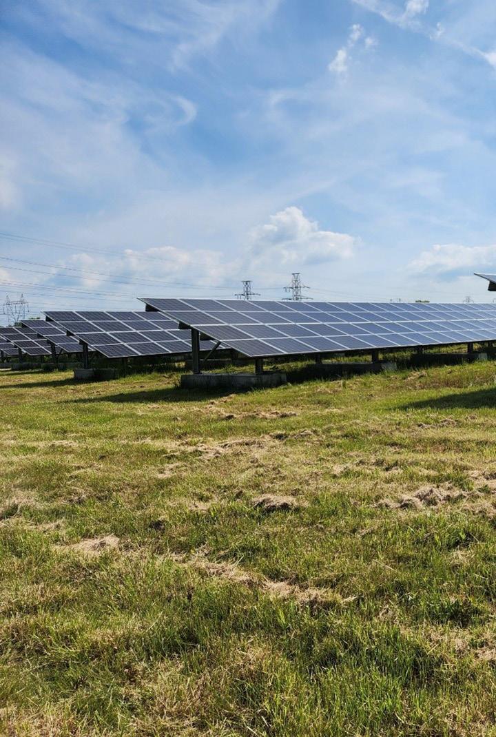
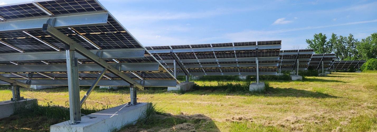
These sites are generally not suitable for residential development and have limited commercial or industrial development potential, making them attractive for solar energy projects. They often have existing stormwater controls, require minimal tree clearing, do not use agricultural land, and tend to be close to electrical grid connections with supportive owners and communities. Redevelopment of landfills and contaminated sites for solar energy is a major priority for many states and the federal government, and attractive incentives are currently available.
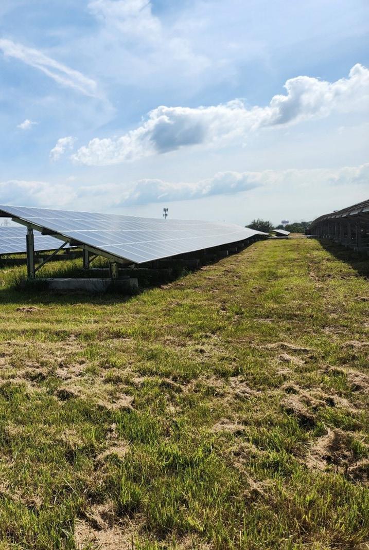
The Niagara Landfill Solar Array (above) was built on a former municipal landfill in the Town of Niagara, NY, that had accepted MSW and C&D waste before being closed and capped in 1987. The project underwent extensive permitting and design due diligence, addressing landfill slope constraints, NYSDEC requirements for array ballasts, and photovoltaic layout and optimization.
When considering whether a landfill or contaminated site is suitable for solar energy development, there are several factors that need to be evaluated:
1. Status of Site: Has the site been properly remediated, covered, and closed? If the site was not properly closed, requires additional cleanup, or is under investigation for emerging contaminants (i.e., PFAS or “forever chemicals”), the site is likely not suitable for development at this time.
2. Type of Contamination or Waste Present: What was disposed of at this site? C&D waste, non-hazardous industrial waste, and MSW are all suitable for landfill development. Hazardous waste landfills are rarely developed due to the nature of the waste they contain and the effects that cover failure would have if it were to occur.
Landfills and contaminated sites present unique opportunities for solar energy development. These areas offer older cities the chance to redevelop formerly vacant sites while generating emissions-free electricity and income. With careful design and construction, these systems can offer substantial long-term benefits.
3. Presence of a Cover System: Many brownfield and Superfund sites utilize a soil cover system to contain residual contamination and prevent it from coming into contact with humans and the environment. Landfills are similar and generally have at least an engineering soil cover system to contain the waste and prevent water from entering them. If a cover system is present, any proposed development cannot compromise the integrity of the cover.
4. Age of Waste: Landfill waste should ideally be at least 15 years old, preferably 30 years or older, to decrease the potential for differential settlement that could damage a solar array and increase the stability of the cover system.
5. Slopes: Ballasted anchoring systems need to be placed on relatively shallow slopes to ensure that a solar array doesn’t slide or cause a cover system to fail. Typically, slopes that are steeper than 6H:1V (i.e., for every 6 horizontal units of distance, there is a 1 unit rise in vertical distance) are not suitable for solar development at these types of sites.
6. Other Engineering Controls:
Long-term monitoring, active remediation, and gas capture and treatment are all common at landfills and contaminated sites. These processes rely on groundwater monitoring wells, pump stations, and gas capture vents to continue operation. Since solar development is secondary to site engineering controls, a solar array design must allow access to these features at all times. Many times, this means that a solar array’s capacity is slightly reduced to allow wells, pumps, and vents to be accessible with heavy machinery.
7. Distance to Interconnection: Finally, the distance to viable interconnection with the electrical grid is a key parameter for solar energy development. If a site is in a remote area or the local grid cannot handle additional electrical input, the costs associated with installing or upgrading electrical infrastructure are likely to be prohibitive to solar energy development.
continued on page 8
Renewable Energy, continued from page 7
Landfills and contaminated sites that are feasible for solar energy development require designs that differ from traditional solar sites. When redeveloping a landfill or contaminated site, the solar array design must address the following items:
1. Anchoring: Panels, racking, and electrical wiring are all traditionally anchored using driven posts at solar development sites. At landfills and contaminated sites, concrete ballasts are typically used to anchor these components in place and prevent them from sliding and overturning.
2. Slope Stability and Settlement: The added weight of using concrete ballasts raises concerns about potential settlement and the stability of slopes. Ballasts are designed to minimize ground pressure and may require geotechnical
calculations to be conducted to ensure that these systems do not damage existing cover systems.
3. Construction Techniques:
Landfills, in particular, are sensitive to the weight exerted by wheeled vehicles. Tracked construction vehicles are generally used to construct solar arrays on contaminated and landfill sites to decrease the pressure exerted on cover systems and reduce the chances of forming ruts.
4. Timing of Construction:
Perhaps the most important consideration is choosing the right time to construct a solar array to avoid damaging an existing cover system and engineering controls. Construction is best suited for drier times of the year and should be avoided during wetter months. Placing ballasts in the winter comes with its own challenges, as frost heave can displace ballasts and impact array construction.
5. Recycling of Panels and System Decommissioning:
Solar panels have a typical lifespan of 30 to 35 years, and many municipalities already require that developers prepare endof-life decommissioning plans for these systems. At the end of their lifespan, site owners and developers can decide whether to install new racking and panels or to decommission the solar array altogether. The U.S. Environmental Protection Agency is currently finalizing universal waste regulations to govern how solar panels will be handled and disposed of in the future.
Despite these challenges, landfills and contaminated sites offer exciting opportunities for solar energy development. Older cities can now redevelop formerly vacant sites, generate emissionsfree electricity right in their own backyards, maintain these contaminated sites, and generate income. Thoughtful design and construction of these systems are crucial but can yield significant benefits in the long run.

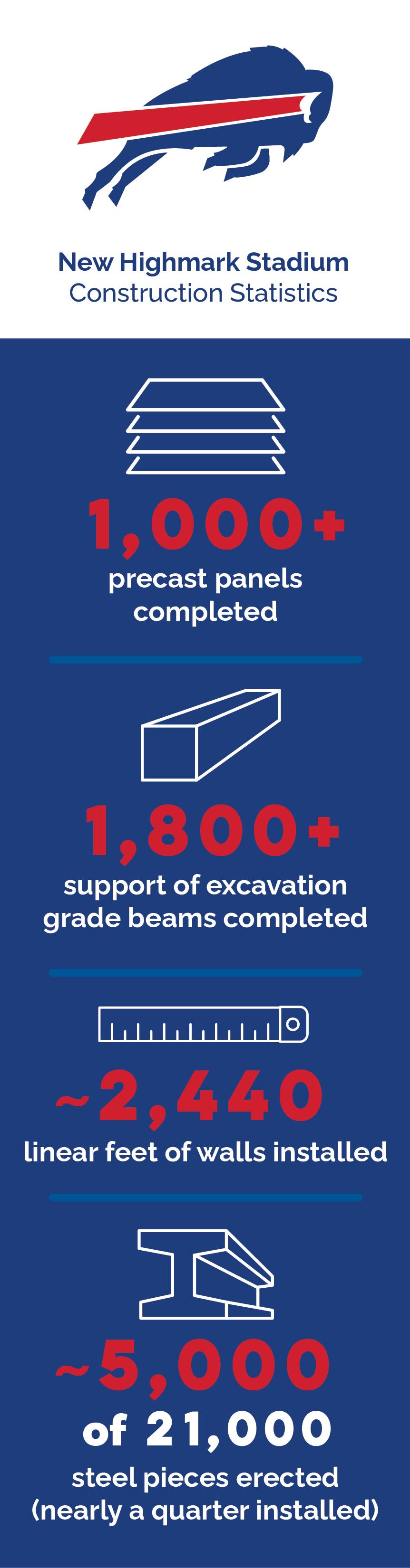
Serving as the lead civil engineering firm on the development of the New Highmark Stadium, currently the largest construction project in Western New York, has been a remarkable experience for the many lifelong Buffalo Bills fans at LaBella.
In its inaugural year of construction, the New Highmark Stadium project has made significant strides towards becoming a cornerstone of community pride and football excellence. Spearheaded by a collaborative effort between Erie County, New York State, the Buffalo Bills, the construction, architecture, and engineering teams, along with the local workforce, the stadium has achieved its initial construction milestones and is on track to be completed for the 2026 NFL season.
Construction began in spring 2023 with the installation of the perimeter fence, “make-ready” utility disconnections, and site demolition.
This work allowed the excavation of approximately 600,000 cubic yards of material for the stadium bowl, with the future playing field designed to be around 35 feet below grade.
Following the mass excavation, a support excavation wall was installed around the perimeter of the bowl, and foundation pours began. The first piece of steel was installed in February 2024. Since that time, over 5,000 pieces of the 21,000 pieces of steel have been erected through year one.
Looking ahead, year two of construction will see the continuation of steel, stadia, the installation of the canopy roof, and site work along the south side of the stadium. The site and stadium will begin to take on their final shape and appearance.
The design and construction teams are committed to delivering this world-class venue, and the community continues to take pride in its progress. We can’t wait to cheer on the Bills at the New Highmark Stadium in 2026!
By Anthony Sanganetti, PE | Program Manager, Transmission & Distribution
“Proper preparation prevents poor performance.” This phrase, coined by James Baker, former Secretary of State and Chief of Staff to President George H. W. Bush, aptly encapsulates the current challenge facing today’s electric utilities. As global efforts to reduce the carbon footprint and decrease reliance on fossil fuels advance, electric utilities—both municipally and investor-owned—must prepare their systems to handle the rising demand. An overall evaluation of the existing electric capacity as well as predictions for the shortand long-term growth of the system are critical. This type of evaluation will enable utilities to strategically plan for the changing energy landscape.
The increasing adoption of consumer electric vehicles and electric school buses, along with widespread electrification across various sectors (such as commercial, residential, and industrial buildings), is placing additional strain on a system that wasn’t designed for it.
According to the U.S. Department of Energy’s Office of Electricity, the nation’s electric grid consists of more than 9,200 electric generating units, which have over 1 million megawatts of generating capacity and are connected to more than 600,000 miles of transmission lines and countless miles of primary and secondary distribution lines. Despite its extensive reach, the U.S. electric grid is aging and inadequately equipped to carry the additional load expected from widespread electrification.


As legislation and customers march toward an all-electric grid, utilities— both municipally and investor-owned—must be ready to manage the additional load. Conducting a grid capacity evaluation is a critical first step toward creating a resilient and reliable electric grid.
With some components of the grid over a century old— far beyond their 50-year life expectancy—and others well into the second half of their lifespans, infrastructure upgrades are imperative to meet future demands. In 2021, the American Society of Civil Engineers gave the U.S. energy infrastructure a grade of C-, underscoring the need for utilities to assess their grid now to ensure there is enough capacity and resilience to support electrification.
A grid capacity evaluation is a comprehensive model of the utility’s electric system and assets, from overhead poles and conductors to transformers and reclosers. The model is used to determine what the existing capacity of the system is, which can identify areas where immediate action is required. In addition, by using growth predictions in the model, a municipal utility can determine what investments will be required over time to ensure their grid can meet the goals of electrification. Having this vital information early in the planning process enables utilities to make well-informed financial decisions about capital improvements to their system, addressing both present and future demand while minimizing the risk of unexpected obstacles and costs that may potentially derail their electrification initiatives.
While the primary focus of this assessment is on capacity evaluation, other services can be integrated into the process, including assistance with protection and Supervisory
Control and Data Acquisition (SCADA) devices and the creation of storm maps and switching schemes. These supplementary services can be seamlessly incorporated into the comprehensive model generated for the grid capacity evaluation, providing a more holistic approach to grid management and planning.
As legislation and customers march toward an all-electric grid, utilities must be ready to manage the additional load. The existing infrastructure lacks the necessary elements to support the surge in demand from upcoming electrification projects. To scale up the aging transmission and distribution network and meet evolving energy needs, substantial upgrades and improvements are essential.
Conducting a grid capacity evaluation is a critical first step toward creating a resilient and reliable electric grid. By taking this proactive step to strengthen the electric grid, utilities can avoid unforeseen expenses and delays, ensuring longterm reliability of the grid and a smoother transition to a more sustainable future.
Achieving electrification goals requires a clear understanding of where the grid is now and planning for where it needs to go. With extensive utility experience, LaBella is uniquely positioned to guide your municipality through the intricacies of grid capacity evaluation, helping you prepare for future growth and meet your electrification objectives effectively.
Can you briefly summarize your professional background and how your previous roles have prepared you for the position of multi-modal planning and design group director at LaBella?
I started as a transportation engineer after college, working on a variety of multi-modal projects involving pedestrian facilities, safety, and transit. My interest grew in understanding how projects reach the engineering phase, leading me
The Multi-Modal Planning and Design Group is comprised of a team of experts in transportation engineering and planning. Their extensive knowledge will be instrumental in serving transit agencies, municipalities, and developers across the U.S. The team is led by Douglas Teator, PE, who joins LaBella with more than 18 years of experience. We sat down with Doug to discuss his new role and what the creation of this new group means for LaBella and our clients.
to dig deeper into the planning phase of our work. This dual focus on planning and design allows us to determine what needs to be done and where at the planning level and then we can bring that into the design. A key aspect I appreciate as an engineer is developing costs and schedules for these needs and then pursuing strategic funding to make it a reality. This brings added value to our clients, particularly municipalities, by identifying and accessing available funding to address their
transportation needs. Our focus on multi-modal transportation and our collaboration with our Planning team means we cover all aspects of urban planning and we can turn great plans into impactful projects.
How does the experience you bring complement and expand LaBella’s existing transportation services?
Our team brings dedicated transportation planning and transit market expertise to LaBella, adding a new layer that
complements and broadens the firm’s existing transportation services. Our strong relationships with transit clients allow us to connect transit agencies with municipalities, aligning their needs and goals. This integration enables us to offer early-phase project planning, including route analysis, and tap into unique transit funding sources to improve local community services and infrastructure. By combining our existing horizontal and vertical transportation work with this transit expertise, we can provide a comprehensive, systems-based approach that benefits both municipalities and transit agencies.
What new markets and/ or services do you plan to introduce to LaBella’s Transportation Group and what steps will you take to implement them?
On the multi-modal transportation side, we plan to focus on leveraging existing municipal relationships and
expanding our grant acquisition capabilities. We will make clients aware of these additional services and utilize our creativity, strategic thinking, and strong performance record to create new opportunities. Key steps include targeting federal discretionary grant programs, such as the Bipartisan Infrastructure Law (BIL) and Safe Streets and Roads for All (SS4A) program and exploring state-level funding sources like the Transportation Alternatives Program (TAP) and Congestion Mitigation and Air Quality (CMAQ) program. Our approach includes not only helping municipalities apply for and secure these grants but also executing the technical work, either in-house or with strategic partners, to address their transportation needs effectively.
What are your long-term goals for the multi modal planning and design group?
Our vision for the multi-modal planning and design group is to expand our services to
all urban areas and states where LaBella currently operates, providing early-phase transportation planning that evolves into comprehensive design, construction, and implementation. We aim to recruit individuals passionate about transportation planning in their local communities, providing them the opportunity to improve transportation infrastructure where they live and work. By addressing common issues such as inadequate sidewalks or disconnects in the transportation system, we seek to enhance community connectivity, which can strengthen long-term growth.
Ultimately, our long-term goal is to establish a dedicated team in each state, driving local transportation improvements and contributing to better community planning and design.
Project Highlight
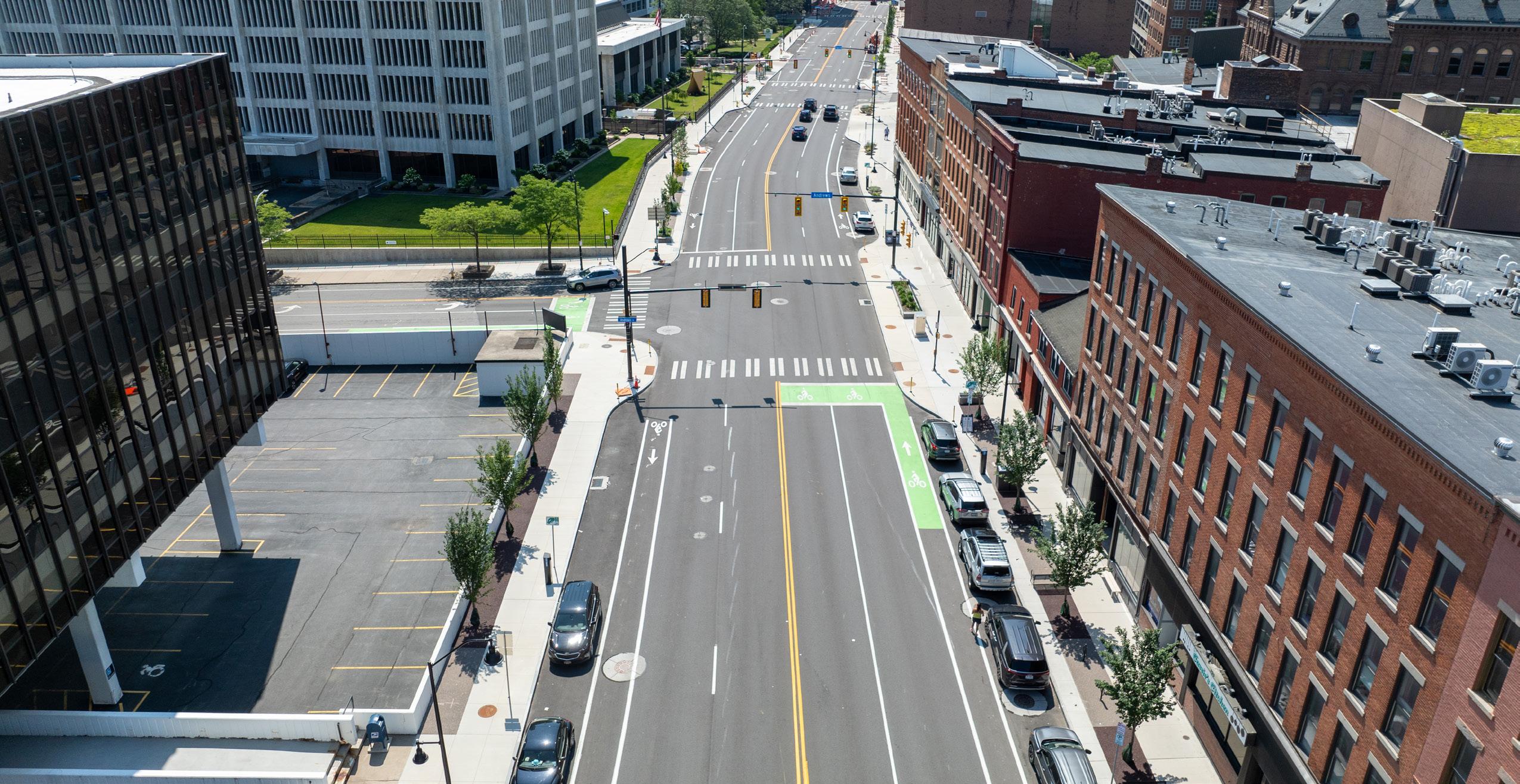
State Street, from Basin Street to the Inner Loop in the City of Rochester, New York, averages daily traffic of 18,000 vehicles. LaBella was tasked with providing transportation engineering services for this principal arterial reconstruction project. This federally funded project follows New York State Department of Transportation Locally Administered Federal Aid procedures.
The project included evaluation and reconstruction options for 0.3 miles of one of the most heavily traveled roadways within the City’s downtown business core.
The roadway, originally built in 1894, required upgrades to restore pavement structure and provide appropriate and modern accommodations for bicyclists, pedestrians, and parking as part of a complete streets philosophy.
Design features included:
• Full roadway and sidewalk reconstruction
• Design and implementation of dedicated bicycle lanes
• Recessed parking via “bumpouts” based on parking study
• Complete signalized
intersection design to provide safe vehicle, pedestrian, and bicyclist crossing
• Significant landscape and streetscape enhancements
• Areaway investigations and condition assessments
• Utility coordination and municipal utility design
• Extensive community advisory committee involvement
• Coordination with NYSDOT and County jurisdictional roadways
and development strategies, transforming neighborhoods.
By Rebecca Smith, GISP | Data Intelligence Lead & Joshua Greene | Planner
Geographic information system (GIS) technology is revolutionizing urban planning by providing powerful tools for collecting, analyzing, and visualizing data related to demographics, housing, land use, and community needs, facilitating data-driven decision-making. These tools can be used to inform policy recommendations and development strategies, ultimately transforming neighborhoods.
Our recent GIS-supported strategic planning project in the Mid-City neighborhood of Niagara Falls, New York, is a prime example of how integrating GIS technology with stakeholder collaboration and community engagement can effectively drive meaningful urban revitalization.
GIS technology integrates location data (where things are) with descriptive information (what things are like there) to create visual representations and perform data analysis, which together can reveal geographic patterns, relationships, and trends. By connecting data to a visual representation such as a map or 3D model, GIS helps users understand and interpret data in a way that can be used to inform decision-making and problemsolving in various fields, including urban planning and community development.
The Mid-City GIS project in Niagara Falls, New York, led by
LaBella Associates in partnership with Niagara University and the Niagara Falls Neighborhood Evaluation Committee, utilized GIS technology to inform strategic planning and decision-making. Specifically, this initiative aimed to thoroughly evaluate housing and community conditions and identify areas for targeted investment in the Mid-City area.
The GIS-driven planning initiative involved working with a steering committee with key stakeholders, including the City of Niagara Falls Planning Department. The committee’s primary goal was to develop a comprehensive housing strategy to improve housing affordability, identify development opportunities, and enhance the overall quality of life for residents, especially historically marginalized groups.
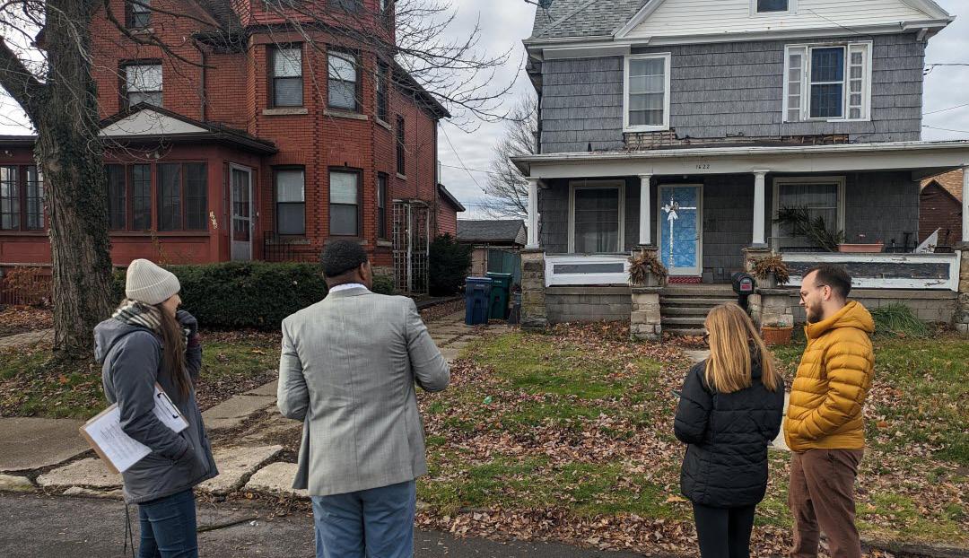
The project involved three main steps: community engagement, housing surveys, and the development of an interactive web mapping tool. Community engagement included hosting open houses and webinars to inform the public and gather insights on local opportunities and challenges, as well as collaboration with Niagara University students for field data collection and GIS analysis.
Housing surveys assessed 3,320 parcels in Mid-City through a general “windshield” survey, rating them from 1 (dilapidated) to 4 (good), and provided a detailed appraisal of 357 houses in two selected areas, evaluating foundations, facades, roofs, and windows on a scale of 1 to 5.
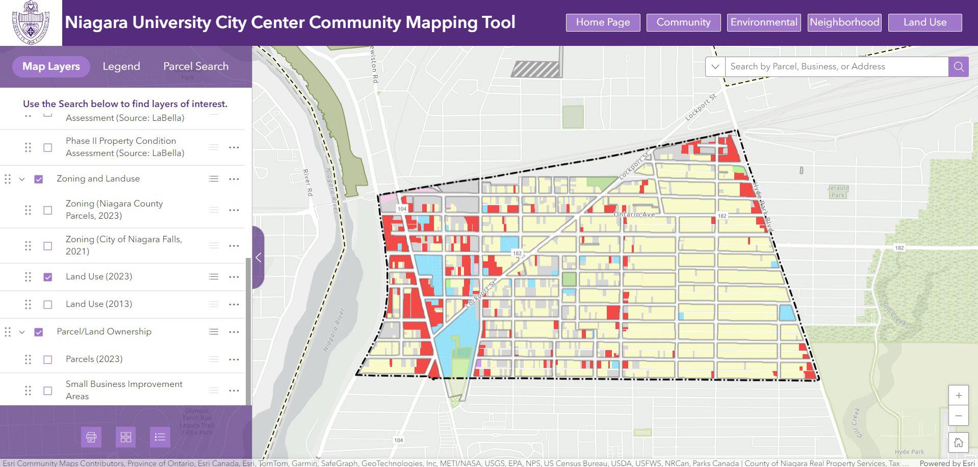
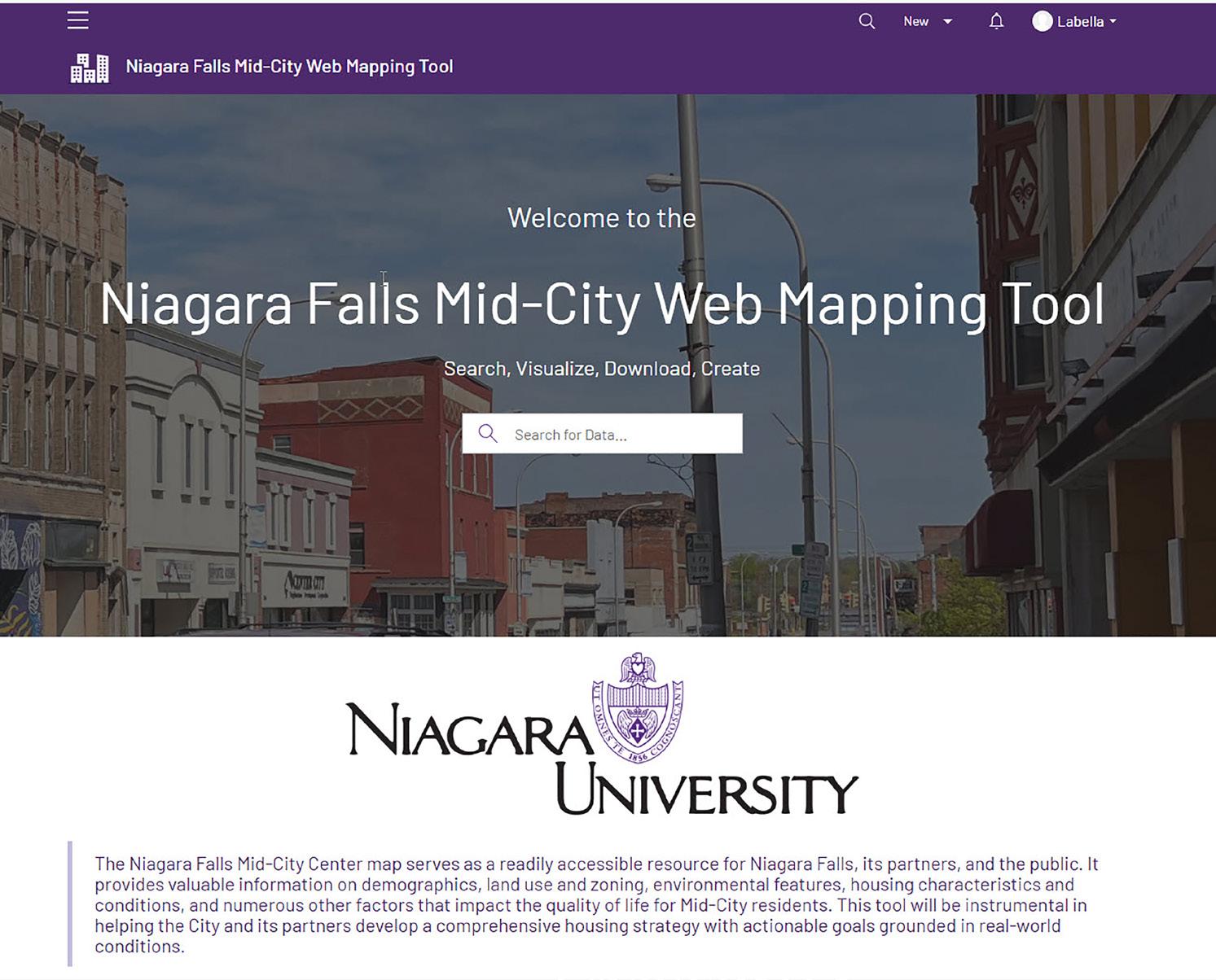
The final product was an interactive online community mapping tool created using ArcGIS Experience Builder and ArcGIS Hub. This tool aggregates all collected data, making it accessible to the City of Niagara Falls, its partners, and the public. It serves as a repository for data to support future development initiatives, policy formulation, and grant funding applications. A webinar was hosted to introduce the mapping tool to interested parties, highlighting its data collection methodology and potential uses.
Integrating GIS technology into strategic planning and community development can provide municipalities with powerful tools for data-driven decision-making. The Mid-City project in Niagara Falls offers several valuable insights— discussed in the sections that follow—into the implementation and benefits of GIS-supported strategic planning.
Collaborating with GIS firms or experts ensures that the necessary technical skills for data analysis and mapping are available. Niagara University and the Niagara Falls Neighborhood Evaluation Committee engaged LaBella’s GIS experts to provide the technical expertise needed for the successful integration of GIS technology into the Mid-City project.
The creation of interactive web mapping tools allows municipalities to visualize a wide range of data geographically, identify areas needing attention, and track progress over time. Tools developed using online platforms make data easily accessible to key stakeholders as well as the public.
In addition, providing regular workshops and training sessions ensures that stakeholders understand how to effectively use GIS tools and data.
The Mid-City project utilized ArcGIS platforms to create an interactive online web mapping tool that serves as an easily accessible resource for the City of Niagara Falls. Following development, a webinar was held to introduce the tool, providing an overview of its data collection methodology and potential applications to stakeholders. This central data repository will be instrumental in helping the City and its partners establish a comprehensive housing strategy backed by actionable goals that are supported by real-life conditions.
continued on page 16
Intelligence, continued from page 15
GIS technology enables municipalities to collect and analyze a wide range of data, including local demographics, land use, housing conditions, and access to community facilities. This comprehensive analysis helps city planners identify areas that need investment and develop targeted strategies to address specific needs. By pinpointing areas requiring attention, municipalities can allocate resources more effectively, ensuring that investments and policies have maximum impact.
In the Mid-City project, analysis of GIS data on demographics, land use and zoning, income and employment, housing conditions, transportation, recreational opportunities, and other variables provided vital insights. This information was used to determine key areas for improvement, support data-driven decision-making, and shape effective policy and development recommendations.
A centralized data repository and interactive web mapping tool can provide clear, evidence-based
justifications for funding requests, helping municipalities strengthen their grant applications.
The GIS-based community mapping tool developed in the Mid-City project was designed to serve as a comprehensive data source. During the webinar introducing the tool, emphasis was placed on its role in supporting grant applications and the potential for integrating additional data sources to aid future community development efforts.
Forming a committee of key stakeholders, including local government, community organizations, and educational institutions, enriches the project with varied expertise and diverse perspectives.
The GIS-driven planning initiative in the Mid-City project involved working with a steering committee of key stakeholders that included the City of Niagara Falls Planning Department, the Niagara Orleans Regional Land Improvement Corporation, Niagara Area Habitat for Humanity, and LISC New York.
The committee set the guidelines for data collection, which will pave the way for developing a comprehensive housing strategy, highlighting the significance of collaborative efforts in urban planning.
Engaging residents and stakeholders through a variety of methods, such as surveys, webinars, open houses, and public meetings, fosters community buy-in and ensures that development initiatives align with community needs and priorities.
Community engagement via open houses, webinars, and Niagara University student involvement played an essential role in the success of the Mid-City project. These efforts informed the public about the project, gathered insights on local opportunities and challenges, and actively involved the community in the planning process.
The Mid-City project in Niagara Falls demonstrates the transformative potential of GIS technology in urban planning. By adopting similar practices, municipalities can effectively harness GIS technology to enhance their strategic planning through data-driven decisionmaking, achieving more impactful development initiatives.
Partnering with a GIS expert like LaBella can help bring these benefits to your community. With our Data Intelligence Group’s specialized skills and expertise on board, municipalities can successfully implement GISsupported mapping and planning to drive meaningful community development and urban revitalization.
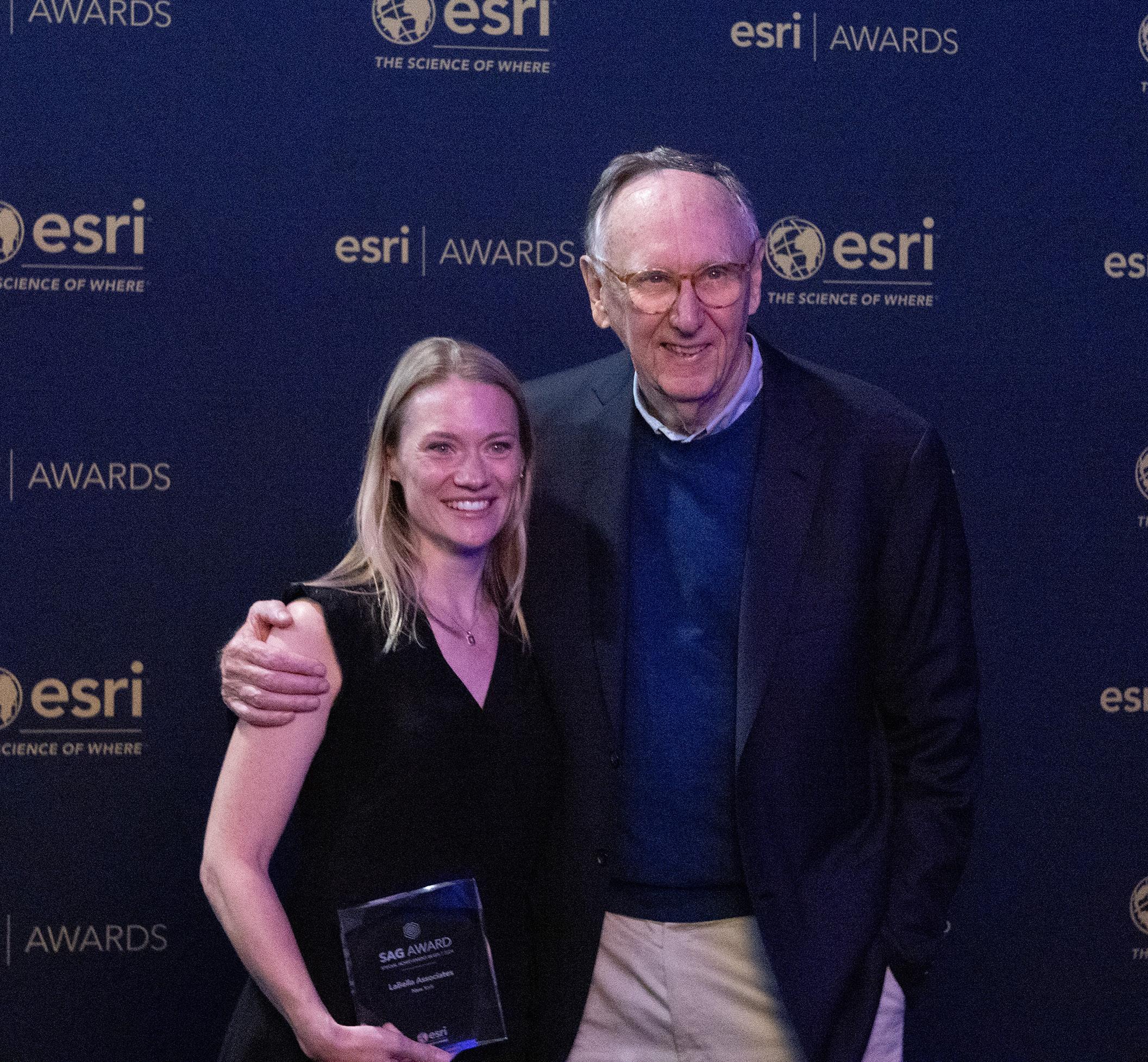
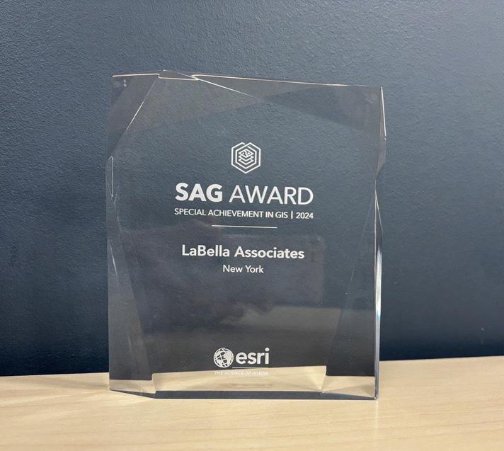
Honored with Esri’s 2024 Special Achievement in GIS Award, LaBella and Niagara University’s project exemplifies how GIS technology can transform neighborhoods by uncovering critical data and guiding impactful revitalization strategies.
In July 2024, LaBella and Niagara University were honored to receive a 2024 Special Achievement in GIS Award from the Environmental Systems Research Institute (Esri) for the GIS-Supported Strategic Planning project in Niagara Falls. This award is given to user sites to recognize exceptional work with geographic information systems (GIS) technology and was one of 197 chosen from more than 100,000 Esri clients worldwide!
This revitalization project in the Mid-City area of Niagara Falls, New York, aims to create a vibrant, equitable, and inclusive community. Through the use of GIS technology, a comprehensive data collection and web mapping effort gathered critical information on population demographics and household metrics, revealing factors contributing to environmental and socioeconomic inequalities. The datasets and mapping tool have been shared with the community and stakeholders to promote collaboration, open data sharing, and data-driven decision-making. Moving forward, the data collected by this project will inform decisions on homeownership and future development initiatives, playing a crucial role in helping the City formulate a comprehensive revitalization strategy with actionable goals.
has partnered with the City of Hornell for over four decades, ensuring the projects we support align with and advance the City’s long-term priorities, including housing rehabilitation, economic development, downtown revitalization, transportation infrastructure, and drinking water and wastewater infrastructure projects.
By: Jennifer Vaughn, EIT | Civil Engineer, Matthew Higgins, PE | Water/Wastewater Engineer, & Hartley Bonisteel Schweitzer, AICP | Senior Planner
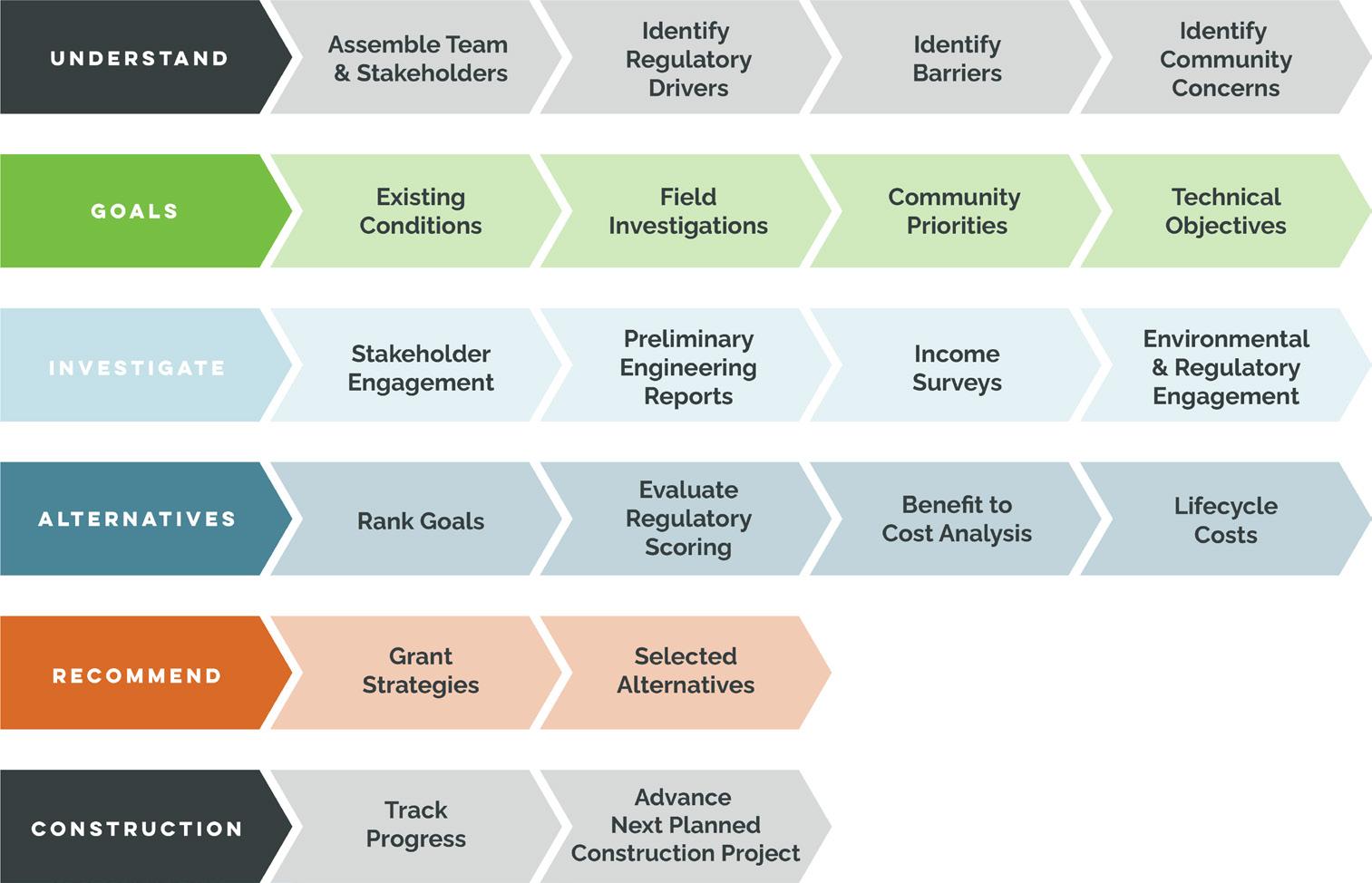
Achieving sustainable development in today’s rapidly changing world requires new strategies that go beyond traditional methodologies. An integrated engineering and planning framework is not just a model but a transformative force for sustainable development. It highlights the power of crossdisciplinary collaboration, where diverse expertise converges to create technically sound solutions that resonate with the communities they serve.
This methodology represents a paradigm shift away from the traditional approach of separate engineering and planning processes, where consultants are activated to solve a challenge and decisions are primarily made by analyzing cost-effectiveness and regulatory compliance.
The integrated engineering and planning approach emphasizes a holistic method for fostering sustainable communities through strategic planning, innovative engineering solutions, and robust community engagement.
The goal of this approach is to foster more resilient and thriving communities.
The following page offers a closer look at the process and outcomes of this approach, highlighting recent experiences and successes in two New York municipalities, the City of Hornell and the Village of Massena.
The integrated engineering and planning approach focuses on developing projects that are aligned with community needs and capable of securing funding, which ensures that the project mirrors the municipality’s collective vision and aspirations. This cross-disciplinary approach allows for comprehensive scoping, planning, evaluation, and advancement to understand community needs, regulatory requirements, and funding opportunities to benefit the community.
A key element of this approach is stakeholder engagement and collaboration throughout the technical planning process. Talking with both municipal leadership and municipal infrastructure operators ensures that community priorities are understood, project goals are clearly defined, and the performance of alternatives is thoroughly evaluated. When leaders from different community sectors are involved in dialogue and decisionmaking, it fosters a more comprehensive understanding of the community’s needs and aspirations, leading to more holistic and widely accepted solutions. Community priorities are not just heard but understood, project goals are not just set but defined, and alternatives are not just considered but thoroughly evaluated.
The success stories from the City of Hornell and the Village of Massena are evidence of the efficacy of the integrated engineering and planning approach.
In Hornell, a decades-long collaboration has led to significant infrastructure improvements, enhancing residents’ quality of life and facilitating economic growth. This partnership includes annual planning sessions between community members and an interdisciplinary planning and engineering team, yielding prioritized projects and a long-term vision. From these planning sessions, significant improvements across various infrastructure projects have been achieved, including water treatment plant enhancements, water distribution system upgrades, and comprehensive evaluations and upgrades to the water pollution control plant. These projects have improved the residents’ quality of life, protected vital waterways, and facilitated economic growth.
The Village of Massena is a current and ongoing example of this approach in action. Planning and coordination with public, private, municipal, and community members to advance projects with complex ownership and rights is the main priority.
The proposed projects mirror the integrated and communitycentric approach to engage a broader set of involved and interested agencies. Through project planning, grant writing, and engineering services, LaBella has worked closely with Village officials and technical operators to align actions with community needs and economic opportunities. This process has already seen the successful administration of grants totaling over $11.7 million for critical infrastructure projects.
The integrated engineering and planning approach exemplifies how comprehensive community engagement, strategic planning, and innovative engineering can foster resilient and thriving communities. The experiences of Hornell and Massena reinforce the transformative potential of an integrated approach and emphasize that success in infrastructure projects extends beyond project completion.