

NeriNga
An Architectural Guide
NeriNga
An Architectural Guide
AUTHORS OF THE TEXTS
Marija Drėmaitė, Martynas Mankus, Viltė Migonytė-Petrulienė, Vasilijus Safronovas
EDITORS
Aistė Galaunytė, Ūla Ambrasaitė
ENGLISH LANGUAGE TRANSLATOR Jeremy Hill CONSULTANTS
Liutaurus Nekrošius, Vaidas Petrulis, Indrė Ruseckaitė
LITHUANIAN LANGUAGE EDITOR Dangė Vitkienė
ENGLISH LANGUAGE EDITOR Gemma Lloyd
PHOTOGRAPHER
Norbert Tukaj DESIGN Aurelija Slapšytė
LAyOUT DESIGNER Kontis Šatūnas
GRAPHICS AND SKETCHES
Aistė Galaunytė, Laura Kuršvietytė, Laura Purlytė, Gabija Strockytė, Elena Paleckytė
PROJECT MANAGER Jonė Juchnevičiūtė
THE PUBLICATION OF THIS BOOK IS SUPPORTED By
Translated from „Neringa. Architektūros gidas“, Leidykla LAPAS, 2020
WE THANK FOR THEIR COOPERATION the Nida Art Colony of the Vilnius Academy of Art, the Museums of Neringa and the architects-designers of published plans.
This book continues the series of architectural guides to Lithuanian towns (Vilnius, Kaunas, Neringa, Palanga) started in 2005 by the Architecture Fund. The architectural guides to Vilnius and Kaunas have already been translated and published in English, German and Polish.
© Leidykla LAPAS, 2022 www.lapasbooks.com
ISBN 978-609-8198-62-1
Dedicated to the nature, people and architecture of NeringaContents
9 FOREWORD Aistė Galaunytė 12 Up to 1945 14 a Short History of the Settlements Vasilijus Safronovas 37 The Historical Origins of the Curonian Spit as a Holiday resort Viltė Migonytė-Petrulienė 71 everyday Life in the Fishing Villages Viltė Migonytė-Petrulienė 96 1945–1990 98 From Fishing Kolkhozes to Prestigious Holiday resort Marija Drėmaitė 127 Modernism Marija Drėmaitė 143 regionalism Marija Drėmaitė 171 Postmodernism Martynas Mankus 190 After 1990 192 architecture after the restoration of independence Martynas Mankus 197 New architecture Martynas Mankus 213 reconstructions Martynas Mankus 230 Outro Martynas Mankus 238 Index of Personal Names 242 Bibliography 246 Authors and Sources 248 Maps

Foreword
Aistė GalaunytėThis architectural guide of Neringa is a story of fishing villages which became prestigious holiday resorts. Published after almost four years of intensive research, discussions and journeys to the coast, it constitutes the first systematic record of the architectural histories of four coastal settlements which, although not large in size, are of special cultural significance.
It became immediately clear after the initial meetings of authors and publishers that the Soviet and modern architecture of the municipality of Neringa had hitherto not been researched on a professional level. The architectural heritage of Neringa from the nineteenth to the start of the twentieth century had attracted greater attention from historians, yet there were still only individual case studies. So an ambitious idea was conceived –instead of giving a brief summary of the already known architectural history (which is the tendency of the ‘guide’ genre), we would conduct what would essentially be new research based on original historical sources.
A paradox exists. While the natural habitat and architecture of this region are now protected, recognised and appreciated, how much do we really know about the history of Juokrantė, Pervalka, Preila and Nida prior to the Second World War? How and why did the social portrait and urban environment of Neringa’s inhabitants change so dramatically in the period after the war? What are the factors shaping the contemporary built environment of Neringa?
It is no coincidence that a large part of this publication is devoted to architecture that no longer exists. The traces of German culture in Neringa from the end of the nineteenth to the start of the twentieth century are still understood in a very fragmentary way. The architecture of the Soviet period deliberately pushed this into the background and is now undergoing irreversible transformation itself. (As this guide was being prepared for publication, two buildings in Neringa included in the book ceased to exist.) This architectural fragility has also inspired changes to the original design and structure of this guide, by affording more attention to the authors’ comprehensive studies and to photos illustrating both past and present of Neringa.
We hope that this book will provide a better knowledge and understanding of this much-loved holiday resort and inspire debate and think the above changes might have resolved the space issue research.
9
Neringa


up to 1945

a Short History of the Settlements
Vasilijus SafronovasThe municipality of Neringa was established by order of the Presidium of the Supreme Council of the Lithuanian Soviet Socialist Republic1 on 15 November 1961. Extending 45 kilometres from north to south, it is today the smallest municipality in Lithuania in terms of the number of inhabitants. Of the relatively large territory of 89.8 square kilometres, the urbanised land used for residential, community and commercial premises and for civil infrastructure occupies 586 hectares or 6.5 per cent of the area. It is composed of four settlements which developed independently up to the middle of the twentieth century - Juodkrantė, Pervalka, Preila and Nida and Alksnynė, the site of a single homestead which belonged to the warden of the dunes. The combined area of these settlements amounts to 33 square kilometres. Within the boundaries of the Neringa municipality were former settlements which have now been covered by sand: Nagliai (also referred to as Agila) and Karvaičiai.
The name Neringa, which was chosen for the municipality in 1961, refers to the whole Curonian Spit (Kuršių nerija). In the mid-twentieth century, Neringa used to refer to what is now called nerija (the Spit) in the Lithuanian language. Strictly speaking the municipality of Neringa only occupies part of the Spit. But there is good reason to examine the northern part of the Spit separately from the southern part, particularly when speaking of the period before the Second World War, when Neringa did not yet exist. Cape Grobštas2 on the Curonian Spit has constituted an administrative boundary as far back as the Middle Ages: at first, it separated the Komturei3 of the Teutonic Order of Königsberg (now Kaliningrad) and Memel (Klaipėda), and later the territories of the parish of Rossitten in the district of Schaaken and the district of Memel. In the nineteenth century it became the boundary between the districts of Fischhausen and Memel,
1 Often abbreviated in this book to ‘Lithuanian SSR’.
2
In Lithuanian, Grobšto ragas
3 A Komturei or Commandery was the smallest administrative district in the domains of the Teutonic Order.
14
Baltic Sea
Sarkau until 1715
Kranz
Kopgalis | Süderspitze
Smiltynė | Sandkrug
Juodkrantė (until ~ 1730)
Juodkrantė | Schwarzort
Karvaičiai | Karwaiten until the until the early-18th century
Nagliai until 1854 Nagliai until 1732
Pervalka | Perwelk
Pillkoppen
Sarkau
Nagliai | Neegeln (until ~1675) (after ~1675) Nida ~1675–1735
Preila | Preil
Nida | Nidden
Nida until ~1675
Neu Pillkoppen
Pillkoppen
Predin 1655–1710
Rossitten
Kunzen 16th to 17th century Kunzen until 1825
Lattenwalde Lattenwalde
~1749–1760
~1652–1749
1728–1839
Karvaičiai until 1797 until 1675
Dang ė Minija Rusnė Gilija
Lagoon
existing
Curonian
Changes in location of
and extinct villages on the Curonian
Spit Map by Vasilijus Safronovas based on research by Friedrich Mager (1938)
and finally, in the interwar period, the border between Lithuania and Germany. In particular, this administrative boundary served as a convenient landmark after the First World War to separate the settlements mentioned above, together with their lands to the north of the Nemunas and the Rusnė, from Germany. At that time they formed part of the German region of Klaipėda, while between 1923 and 1939 (and again from 1945) they and the whole region belonged to Lithuania.
For many centuries the current territory of Neringa formed part of a different political and cultural system to the majority of Lithuania today. As the Teutonic Order consolidated its power in Prussia in the thirteenth century, and the knights of the Brothers of the Sword were incorporated into the Order in 1237, the Spit found itself situated between the two castles of the Order in Memel and Königsberg. Up until then, it had functioned as a bridge of communication between Sambia and Žemaitija 4 Now it became the junction between the domains of the Teutonic Knights in Prussia, Curonia and Livonia.
This role of the Spit in regional communication would become defining, together with the fact that, as military tension subsided between the Teutonic Order and the Grand Duchy of Lithuania, the first settlers began to move into the Spit from Courland to the south, along this axis of communication. They called themselves Curonians or Cours5 , while the Prussian Lithuanians on the other side of the lagoon called them the ‘dune people’6 .
In 1525 the Grand Master of the Teutonic Order converted from Catholicism to Lutheranism and took the title of Duke of Prussia. His subjects were compelled to follow the Duke’s example and also become Lutherans, though the tenets of Protestant theology were slow to penetrate the outlook of the fishing people of the remote Curonian Spit. This is not altogether surprising: although there is mention of the oldest places of worship in Rossitten (Kunzen) as early as 1506, the entire Curonian Spit was still for a long time served only by a single priest. Alongside Lutheranism, Lithuanian and German cultures forced their way into the peninsula, turning the settlements of the Spit into a multicultural mosaic. Even in the nineteenth century, the local inhabitants with their different family roots spoke a Curonian dialect, as well as Lithuanian and German: they adhered to the Lutheran faith and were loyal subjects of the Prussian King (from 1871 the German Kaiser).
4 Žemaitija is also referred to in English as Samogitia.
5 In Lithuanian, kuršininkai or kuršiai.
6 In Lithuanian, kopininkai.
16
There were several factors which influenced the development of settlements on the Curonian Spit. One of them was the fact that the peninsula was the shortest and safest route for communication between Courland and Livonia and the rest of Europe. The metalled road of today (previously made of gravel) was laid only at the start of the twentieth century. Up until then, the road from Kranz to Rossitten ran along the lagoon; from Rossitten to Sandkrug (Smiltynė) it was closer to the sea, while in several stretches to the north of Karwaiten (Karvaičiai) it ran directly along the sandy shore. For several centuries this artery of land communication was the only route available for those travelling from St Petersburg, Reval (now Tallinn), Narva, Dorpat (now Tartu) or Riga, and heading for Königsberg (now Kaliningrad), Elbing (now Elbląg) or Danzig (now Gdańsk), or going on from there to other towns of Central and Western Europe, or the other way round. In the fourteenth and fifteenth centuries, it seems that only the southern part of this road was more actively exploited. Inns were opened next to it, in Sarkau (first mentioned in 1408) and in Rossitten (1389). Furthermore, this section of the road was only travelled in winter since, immediately beyond Rossitten, people making their way to Cape Ventė 7 (where there was a Teutonic Order castle) used to cross the Curonian Lagoon on the ice. However, after the peace treaty of Melno in 1422, there are records of inns opening up, almost equidistant from each other, in Nidden/Nida (first mentioned in 1437), in Neegeln/Nagliai (1447), and in Vitte/Vitė and Nimmersatt/Nemirseta on the outskirts of Memel/Klaipėda (1434). It is thought that an inn going by the name of Treyeros was also open for business in the fifteenth century in what would become Karwaiten, mentioned first in sources from 1509, together with the so-called Sandkrug (‘sand inn’) opposite Memel, where travellers had to wait for the ferry. This evidences the start of active exploitation of the land route.
For a while, the road served the needs of the Hanseatic League, and in the first half of the seventeenth century, as the provision of regular postal services took off in the surrounding region, the old road became an ‘official’ postal highway whose significance continued to grow. For almost two centuries, the road was used for the exchange of information, delivery of correspondence and the journeys of merchants, intellectuals, nobles and monarchs of European states, from one part of Europe to another. As a result, the settlements of the Curonian Spit expanded, together with all the infrastructure required for them to serve as intermediate stopping
7 In Lithuanian, Ventės ragas.
17
points (inns, post houses, places to change horses and guard posts). At least some of the Spit’s inhabitants were permanently engaged in meeting the needs of travellers and messengers. Only in 1833, when the new post road was laid between Tauragė and Šiauliai, did the road along the Curonian Spit revert to being used primarily for local communication. The old businesses connected to the postal services died out, and apart from fishing, there was nothing left for people to do on the peninsula.
Another important feature of the development of the Spit settlements was their constant dependence on the specific natural conditions. With the exception of a small area of land near Rossitten and scattered outcrops of meadows, the land on the Curonian Spit was poorly suited to both arable and livestock farming. The result was that, already by the sixteenth century, fishing was the main source of livelihood for the sparse inhabitants of the narrow sandy strip between the sea and the lagoon.
At the same time, the sources note that, as early as the sixteenth century, the inhabitants’ homesteads and meadows were threatened by sand blown into drifts by the wind. Over time this forced them to abandon their homes and move from one place to another. In the seventeenth century it seems that small groups of trees still provided protection from the sand for the small clusters of homesteads which had formed on the Spit. But, due to the persistent felling of the forest over the centuries, after the Seven years War (1756–1763) small areas of pine were left only in the vicinity of Schwarzort/Juodkrantė and Nidden/Nida. The people of Schwarzort and Nidden managed to survive in their struggle against the drifting sand, though these villages today are no longer in their original locations.
Karwaiten and Neegeln, however, suffered a different fate. Neegeln moved location three times, though today only a bay, a dune and a cape8 –the promontory to the south of Juodkrantė – continue to bear its name. Between 1836 and 1845 the village itself was finally overwhelmed by the sand. The village of Karwaiten – from 1739 the parish centre in the northern section of the Spit, situated between Pervalka and Preila – was also covered by sand several times in different locations. Between 1781 and 1798 all the inhabitants of Karwaiten gradually moved elsewhere, including the priest, the teacher and the innkeeper. This event is described in the elegy ‘The Sunken Village’ (1797) by Liudvikas Rėza (Ludwig Rhesa), who was born in Karwaiten and later became a professor at the University of Königsberg.
8 Naglių ragas, or Nagliai Cape.
18
In the first half of the nineteenth century, travellers continued to describe the Curonian Spit as an eerie wilderness. But soon systematic attempts were undertaken on the Spit to keep nature in check, by forming a protective ridge and planting vegetation to hold back the sand. In the northern part of the peninsula, measures to control the drifting dunes were first adopted in the late nineteenth century and early twentieth century near Nida, Preila and Pervalka, which were under greatest threat, and in the strip between Süderspitze/Kopgalis and Juodkrantė, where the measures were intended to protect the straits and the harbour from the drifting sand.
The third and final factor driving the growth of the settlements was industrialisation, whose influence was felt in two ways.
On the one hand, it manifested itself through the industrial mining of amber from a deposit in a stretch of the Curonian Lagoon lying off Schwarzort/Juodkrantė (A33), which was accidentally discovered during the dredging of a navigation channel. The company Stantien & Becker, owned by Friedrich Wilhelm Stantien and Moritz Becker, merchants from Memel, acquired the right to extract amber at this location. Up until then, they had been prospecting for amber not far from Prökuls/Priekulė, and in 1875 they acquired the right to extract amber from a huge deposit in Palmnicken (now yantarny, in the Russian region of Kaliningrad).

19
The veranda of the Hermann Blode Guest House
In the three decades before 1891, amber was mined commercially in Juodkrantė, involving over a dozen suction dredgers, divers, and between several hundred and more than a thousand hired seasonal workers, working in shifts. All of this turned the mine, together with its workshops for repair and fitting of the dredgers, the factory for steam engines and boilers, and several specially designed steamships, into one of the largest industrial undertakings in the whole of East Prussia. The amber was marketed not only in Southern and Eastern Europe but also in East and SouthEast Asia.

20
The Strandhalle Restaurant on Juodkrantė beach, 1910
On the other hand, the industrial way of life was slow to penetrate the Curonian Spit, and the fishing villages of the peninsula soon became a refuge for those seeking a haven from civilisation, industrial change, and progress. The first to discover this refuge, around 1850, were individual painters from the Königsberg Academy of Arts, and several decades later, a small circle of artists, who were regular visitors to the Curonian Spit, was formed.
In 1867 Friedrich Blode established a hotel in Nida (A19) which, on the initiative of its owners who were patrons of the arts, became by the

21
turn of the century a true gallery of paintings and graphic art. At the exhibition ‘The Curonian Spit in Science and Art’ (Die Kurische Nehrung in Wissenschaft und Kunst) held in May 1914 at the Königsberg Art Gallery, the works of 37 artists (191 works in total) were displayed, in which Nida motifs predominated.
It is reckoned that at this time there were already around 200 artists active on the Curonian Spit, among whom Lovis Corinth stands out. His impressive work The Fishermen’s Cemetery in Nida (Friedrichshof in Nidden, 1893) had an influence on German Impressionism, and on the painters Ernst Bischoff-Culm, Hans Beppo Borschke and Max Pechstein in particular. Most of them were attracted by the wildness of nature, the special charm of the contrasting colours embedded in the landscape and, above all, the primitiveness of the fishing villages still barely touched by civilisation. Ernst Mollenhauer, who in the period between the wars became the ‘soul’ of the colony of artists at Nida, was one of the few artists who lived permanently on the Spit. The driving force behind the artists coming to stay for the summer months on the Spit was the desire to break free from the culture of the large towns, seen as tainted by progressive attitudes. Thomas Mann, the winner of the Nobel Prize for Literature, was also tempted by Mollenhauer and, unable to resist, by 1930 had already come to Nida to stay at the summer house he had just built (A23).
However, it was not only artists who sought refuge from civilisation and progress in the Curonian Spit villages but also wider representatives of the industrial social classes, especially the town-dwellers of Königsberg, Tilsit (now Sovetsk) and Memel.
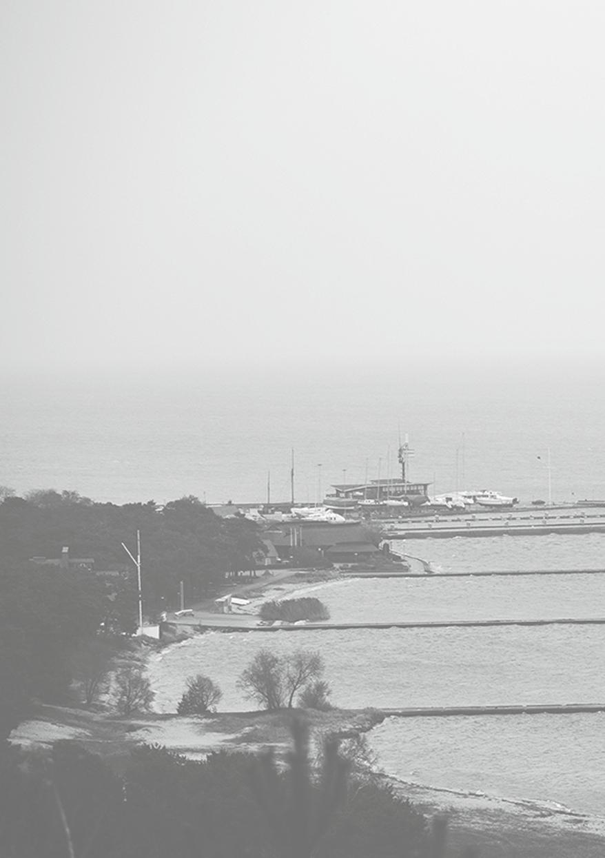
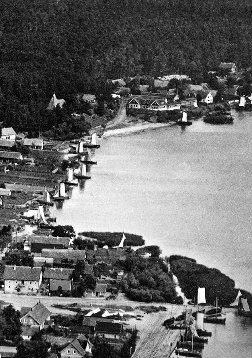
In the second half of the nineteenth century, Schwarzort/Juodkrantė became the most significant attraction, where the routine life of the fishermen was enlivened by the development of a first-class seaside and spa resort established around 1880. In 1865 Eduard Stellmacher from Tilsit founded a hotel, the Kurischer Hof (A02), on the site of the former inn, which from the very beginning offered services for holidaymakers. However, in 1881 a special resort committee was established, composed mainly of merchants from Memel and Tilsit, which collected a holidaymakers’ tax, organised entertainment and maintained the infrastructure. In 1879 they started to build a quarter of hotels and villas, and the construction of a jetty in 1880 and of a departure hall nearby in 1891 made it easier to travel to the village by steamboat. Up to that time, visitors had to disembark into small boats to cover the remaining 100 metres to the shore. It was possible
22
during this period to reach Juodkrantė by a regular schedule of steamers from Memel, Tilsit and Kranz (now Zelenogradsk).
In 1885, at the invitation of the firm Stantien & Becker, a doctor came and settled in Juodkrantė, followed later by the opening of a chemist’s during the season. Finally, in 1888, the first tourist guide of Juodkrantė was published. There were festivals for religious missions and tourist hostels for students and schoolchildren.
The resort potential of the area developed particularly intensively before the First World War: in the last years of the nineteenth century, the resort was visited during the season by 1,500 to 1,700 holidaymakers, in 1902 by 2,352, and in 1913 by 4,071 registered guests. In the interwar period, holidaymakers in Juodkrantė had access to mud baths, baths with sand steam or carbonic acid, tennis courts and other facilities.
In 1912 Nida was also granted the status of spa resort. Here too, over several years youth Tourist Hostels (A21) were established (the first was opened in the hotel owned by Hermann Blode (A19)); works continued on the improvement of the jetty, beginning with the construction of piers between 1903 and 1904, adapting it for use not only by fishing vessels but also by larger steamers, as well as plans to build a departure hall.
Nida’s transformation into a resort rivalling Juodkrantė was interrupted by the outbreak of the First World War, and its role only began to strengthen during the interwar period. By 1930 the number of holidaymakers in Nida had outgrown the space available. By the 1930s, 3,500 to 4,500 registered holidaymakers were visiting Nida every year, compared with 2,300 to 4,100 visiting Juodkrantė.
The mainstay of tourism in both Juodkrantė and Nida was the German speaking people from Königsberg, Tilsit and, to a certain degree, from Memel. Thus, these villages on the Spit served as holiday resorts for the town dwellers of the region most affected by industrialisation. Before the First World War, there was even discussion of the possibility of linking the summer resorts with Kranz (and thus with Königsberg) by a narrow-gauge railway. At that time neither Preil/Preila nor Perwelk/Pervalka were conceived as potential holiday resorts. They were called the ‘miserable German fishing villages’.
A similar trend prevailed in the interwar period. The number of Lithuanian holidaymakers in Nida increased only after the establishment of the officers’ sanatorium (in Johann Rademacher’s villa) and later on, the gliding school (A25). Even in 1932, the Lithuanian press wrote that in Juodkrantė ‘there is no sign whatsoever of the Lithuanian spirit’.
23
 Panorama of Nida
Photo: Paul Isenfels, 1940
Panorama of Nida
Photo: Paul Isenfels, 1940
Villa Flora
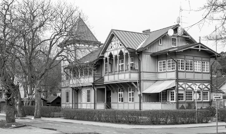
Kalno g. 7, Juodkrantė 1868
Today this building is often called the Juodkrantė Kurhaus. It was, however, constructed in the middle of the nineteenth century as one of the first villas. The residence was built by Moritz Becker, one of the owners of the amber mining firm. The owner and his family would use the villa for holidays. When the firm’s activities in Juodkrantė ceased, the building was converted into a boarding house, in which 25 rooms were let out to holidaymakers. The wooden building, with its main façade facing towards the lagoon, was one of the smartest and most luxurious in the architectural environment of the time. Two monolithic three-storey wings, connected by a two-storey rectangular block, shaped the building’s symmetrical composition and gave it a representational character. The villa’s balconies, cornices, profiled window surrounds, wind-boards and walls are decorated with stylistic carved details. In front of the building’s main façade was a terrace which was used as an outdoor café.
The villa was attractive to holidaymakers of the time on account of its well-kept garden, its flower clock and the only working fountain on the whole
of the Curonian Spit. The building has retained its authentic form and residential use up to the present day.

A32 38 a 01
GROUND FLOOR PLAN

39
Kurischer Hof Hotel (now the Gintaras Holiday House)


Kalno g. 12, Juodkrantė
Second half of the 19th century
The story of this building is closely associated with Eduard Stellmacher and symbolises the transition of Juodkrantė from a fishing village to a holiday resort. In 1865 he acquired the old village inn when it went bankrupt, and established in its place the resort’s first hotel, which in the interwar period became a genuine spa house. The brick house stood on a hill, at a short distance from the shore of the lagoon, by the old Klaipėda road which led from Juodkrantė towards the sea. After a fire in 1879 the hotel was rebuilt with two completely new annexes (blocks), which were called the ‘Schweizer Haus’ and the ‘Waldhaus’. Rooms were also installed in the mansard space, and opposite the long wooden veranda, decorated with openwork, there was an outside café with a spacious garden, which operated right up to the beginning of the Soviet period. In 1960 the Gintaras Holiday House was opened here as a base for herring fishing expeditions. A few decades later, the impressive ornamental elements on the veranda of the former hotel were destroyed, and later the veranda itself.
40 a 02
The Kurischer Hof Hotel, Juodkrantė, 1925–1930
The Gintaras Holiday House, photo: Norbert Tukaj, 2017
Kalno g. 12, Juodkrantė
End of the 19th century
In the nineteenth and twentieth centuries buildings of this type were often built in holiday resorts next to the most important and luxurious hotels and restaurants, as well as in avenues and parks where there were the largest concentrations of holidaymakers. The wooden music pavilion in Juodkrantė, which has survived to the present day, illustrates the significance for the resort of the Kurischer Hof Hotel which stands on roughly the same site. In the interwar period, this complex was advertised as preserving the ‘old traditions’ and so became very popular. At any one time it was capable of accommodating up to 100 guests. The pavilion was probably built slightly later than the adjacent hotel established on the site of the former old inn. Most likely an orchestra would give concerts here, which would be listened to by those seated in the summer restaurant or hotel guests taking a walk in the well-maintained park. As was common for buildings with a similar function in this period, Juodkrantė’s music pavilion was adorned with decorative elements, noticeable primarily in parts of the cornice, lintels and flagstaff. However, the openwork carvings do not

have elements which are especially characteristic of the lagoon area. For this reason one can appreciate the building and its aesthetic as a characteristic example of small-scale architecture of the resort environment.

41 a 03
The Music Pavilion
Kalno g. 5, Juodkrantė 1883
Like a number of the oldest holiday buildings in Juodkrantė (Villa Hubertus (A08), the Kurischer Hof Hotel (A02), together with the music pavilion), this villa belonged to the Stellmacher family. It was their summer holiday residence, named in honour of Eduard Stellmacher’s daughter Elisabeth. In the nineteenth century it was one of the most luxurious houses in the Villa Quarter (Villenviertel). The building was distinguishable from the nearby villas in Kalno gatvė by the untypical composition of the façades. Unlike most of the other villas built at the turn of the nineteenth and twentieth centuries, the roof of the two-storey ‘Elisabeth’ is flat. The villa unusually combines classic forms of German architecture – half-timbered, brick and wood. The most decorative aspect of the villa is the avant-corps, which is set not completely symmetrically in the main façade, and ‘dressed’ with glazed verandas. The gables are embellished with decorative wooden carved details, echoing the façade patterns of Villa Bein on the other side of the road. The structure of the villa survives and remains unchanged to this day and still bears the inscription ‘Villa Elisabeth’ on the side façade.

42 a 04 Villa elisabeth
The process of industrialisation, which started in the middle of the nineteenth century, was responsible for causing diseases of the lungs (primarily tuberculosis) and other illnesses in most of Europe and beyond. This led to the creation of health infrastructure in spa resorts endowed with favourable natural conditions. Juodkrantė was no exception. At the beginning of the twentieth century, as the number of new settlers increased on account of the amber mining, the question of the hygiene of the premises in the settlement became highly topical. In the majority of the dwelling houses there was no ventilation system. The houses were still without chimneys. For this reason a sanatorium was built in the developing resort. Mrs Louise Stellmacher donated the plot, while the community and the Resort Company raised the building costs. The building with ornate German architecture became not only an important centre of restorative health for the local inhabitants and (predominantly) for visitors to the resort, but also an attractive visual highlight which was advertised to travellers in various publications. Situated not far from the harbour and the villa quarter, the brick
building of fairly substantial size was graced with an expressive half-timbered tower. In the sanatorium baths of hot salt, pine needles, carbonic acid, mud and fresh water were available, together with baths and showers of sand and steam. The complex has not survived.

43 a 05
The Luisenbad Thermal Baths (no longer extant)
Luisenbad, Juodkrantė, 1900–1910
The corner of Miško and L. Rėzos g., Juodkrantė 1905
Kalno g. 20, Juodkrantė 1904
This villa, one of the largest villas of Juodkrantė (also known as Villa Loebell), belonged to Cecilia Bein, the owner of the Variškiai/Warrischken Estate by the Nemunas River (in the District Tilsit). The rectangular wooden two-storey building evolved over time. A spacious gallery embellished with openwork carvings encircled the northern and eastern façades of the ground floor of the villa, while a balcony was incorporated on the first floor of the eastern façade. It is likely that these elements, which created an impression of lightness and space, were added during the Soviet period. At the same time a glazed veranda was installed in the northern façade, and next to this, a small terrace with an entrance. Although the villa has not been renovated since 1991, valuable fragments of ornamentation of the wooden façades have survived within it. It is also possible to see similar elements in other villas in Kalno gatvė, for example, in the neighbouring Villa Jenny (A07). The repetition of characteristic decorative features when building villas nearby is a common phenomenon in the resorts of the time, illustrating the ambition of the owners to create a luxurious image attractive to holidaymakers.

44 a 06 Villa Bein
GROUND FLOOR PLAN
Kalno g. 22, Juodkrantė
This is one of three villas in the Villa Quarter (Villenviertel) built on the slope of a dune in the second half of the nineteenth century, which almost every visitor to the resort admired and which attracted considerable attention from photographers and postcard publishers (the other two were Villa Monbijou (A09) and Villa Loebell). According to the sources, the building belonged to Louis Müller.
The villa is distinguished by an untypical blend of brick and wood, which is characteristic only of resort buildings in Juodkrantė. The first, wooden, block of the building conforms to the general character of construction along Kalno gatvė. The two-storey part of the main façade (cornice, walls, balcony railings and so forth) is adorned with decorative wooden carvings. The veranda and terrace on the eastern side – one of the most characteristic features of resort architecture – served not only as a refuge from the wind but also influenced certain rituals of fashionable and highsociety holiday life. It is probable that the brick annex, which also included holiday rooms, was built somewhat later.
The villa, which was renovated between 2015 and 2016, together with other ‘celebrities’ on Kalno gatvė, has survived to this day, with the exterior little changed.

45 a 07
Villa Jenny
1881
GROUND FLOOR PLAN
Villa Hubertus
Kalno g. 4, Juodkrantė 1899This villa belonged to Louis Stellmacher, the son of Eduard Stellmacher, who took over the business after his father’s death. The building at that time had a distinctive purpose and significance. In addition to the family and single rooms available for renting, the premises contained a post and telegraph office together with a forestry accounts office. It was also where the Vogt for the coastal region worked – an official with administrative and judicial functions and responsibility for public security. The villa stood on a plot which previously belonged to to the district inn. The villa, which was adapted for these various activities, was endowed with impressive architectural forms. In the interwar period it was famous for its ornamental garden. The most eye-catching feature of the building in historicist style are the tower and the central avant-corps, prominent on the southern façade, with a pediment of complex cantilever construction. The villa was richly decorated with openwork ornamentation with floral motifs. The galleries and verandas have also survived to the present day.
 GROUND FLOOR PLAN
46 a 08

47
Kalno g. 26, Juodkrantė 1881
This villa, with the French name ‘Monbijou’ (‘My Jewel’), is to this day perhaps the most luxurious in Juodkrantė’s Villa Quarter ( Villenviertel ) and the first in the famous trio of villas in Kalno gatvė (alongside Villa Jenny (A07) and Villa Loebell). The Dedat family, who had come to Juodkrantė from Eitkūnai/Eydtkuhnen, built the villa for themselves in the 1880s. The building belonged to these owners until the First World War but was later expropriated and used by representatives of the Klaipėda city authority and their guests. Over the period of its existence, the villa has given rise to several intriguing legends. According to one of these, the Marshal of the Reich, Hermann Göring, stopped off at the villa when he came to Juodkrantė to hunt, and so the villa erroneously acquired the name ‘Villa Göring’. From the 1960s a library was housed in the building, while during the years of independence the village council and a health service facility were established here. The villa is almost unchanged, although the annex previously on the right with a glazed veranda has not survived, nor has a metal openwork pergola which stood on the same plot, in a large terrace
garden. At present, the Juodkrantė village administration works in the building, while its annex (Kalno g. 28) has been adapted for residential use.

48 a 09 Villa Monbijou
GROUND FLOOR PLAN
Ievos kalno g. 4, Juodkrantė 1930s
The scale of construction of buildings for leisure and recreational use in Juodkrantė did not, in the interwar period, match the relatively intensive programme of such construction at the end of the nineteenth and start of the twentieth centuries. However, after the Second World War, one can find more interesting villas. One example –a short distance away from the luxury Villa Quarter (Villenviertel), by the former Rosengartenstrasse –is a small wooden house designed and built in the 1930s. The architectural appearance of this villa is closer to that of the traditional dwelling houses on the shore of the lagoon than other resort buildings, which were often distinguished by the ornate and whimsical composition of their façades. Today the villa has retained its authentic forms and function. The two-storey avant-corps placed on the front façade attracts attention for the way it varies the size and substance of the building. One of the characteristic elements of the villa is its high brick plinth. It is also possible to observe on the building, as with villas of the earlier period, several profiled carved details (for example, on the cornice, the decorations above the windows etc.).

49 a 10
Unnamed Villa
GROUND FLOOR PLAN
NeriNga
An Architectural Guide
Printrun 1000
PUBLISHED By Leidykla LAPAS K. Kalinausko g. 10–3, LT-03107 Vilnius info@lapasbooks.com www.lapasbooks.com
