JUAN CAMILO GIRALDO MORALES
Bogota, Colombia/Barcelona, Spain
+573168760854 / +34602575475
juancamilo.giraldo2602@gmail.com behance.net/juancgiraldom linkedin.com/in/juancgiraldom
I am an architect and civil engineer with great interest in city planning. I am passionate about urban phenomena, the conflicts between infrastructure and its surrounding elements. I am interested in understanding the way people inhabit and move through public space. I love maps and urban analysis, and therefore I see great potential in understanding and planning cities from Big Data and new technologies. I dream of making cities more livable and more democratic from public space. And, especially, I dream of providing Bogota, my home city, with the tools so that public space stops being perceived as foreign and intimidating and becomes a place of identity and appropriation.
SKILLS
PROGRAMMING LANGUAGES
Python R
SQL
Visual Basic (VBA)
HTML + CSS + JavaScript
SOFTWARE
Adobe Creative Suite
Adobe After Effects
Adobe Illustrator
Adobe Photoshop
Adobe InDesign
AutoCAD
SketchUp
Rhinoceros (+ Python)
Grasshopper
Revit
ArcGIS/QGIS
Microsoft Office (+ VBA)
Microsoft Excel
Microsoft Access
Microsoft PowerPoint
Microsoft Word
Microsoft PowerBI
PTV Visum (+ Python)
LANGUAGES
Spanish English
French
EDUCATION
ARCHITECT
Universidad de Los Andes, Bogota August, 2014 - April, 2021
CIVIL ENGINEER
Universidad de Los Andes, Bogota August, 2015 - April, 2021
MASTER IN CITY & TECHNOLOGY (ONGOING)
Institute for Advance Architecture of Catalonia, Barcelona October, 2023 - July 2025
WORK EXPERIENCE
MOBLITY & TRANSPORT CONSULTANT
Idom Consulting - Mobility & Transport February, 2021 - July, 2023
INTERN
Idom Consulting - Mobility & Transport January, 2020 - July, 2020
OTHER COURSES
MACHINE LEARNING IN DECISION MAKING
MIT Professional Education
August, 2021
APPLIED MACHINE LEARNING IN PYTHON
University of Michigan
July, 2021
PYTHON GEOSPATIAL DATA ANALYSIS
Coursera
July, 2021
Native Advanced Intermediate
HIGHLIGHTS
CONSULTING
Positioning strategy for the Network of Creative and Cultural Districts of Bogota, Colombia (August, 2022 - Ongoing)
Client: Secretariat of Culture, Recreation and Sports Tasks:
•Analysis of accessibility to the districts
•Analysis of mobility flows and determination of strategic access and connection points in the prioritized districts
Accessible and Safe School Routes in São Paulo, Brazil (January 2022 - December 2022)
Client: The World Bank Tasks:
•Definition of the intervention strategy at the urban and neighborhood scale
•Field work assistance
Structuring of TransCaribe S.A. to achieve continuity of service, Cartagena, Colombia (March, 2021 - Ongoing)
Client: Financiera de Desarrollo Nacional - FDN Tasks:
•Technical coordination of input databases
•Development of diagnostic dashboard in PowerBI
•Calibration of macroscopic transport model
Optimization measures for TRANSMILENIO S.A. to respond to the impacts caused by the COVID-19 pandemic, Bogota (August, 2021 - March, 2021)
Client: International Finance Corporation - IFC Tasks:
•Technical coordination and project management
•Development of monitoring dashboard in Python/ Dash
•Data analysis of trunk and zonal components of TransMilenio S.A.
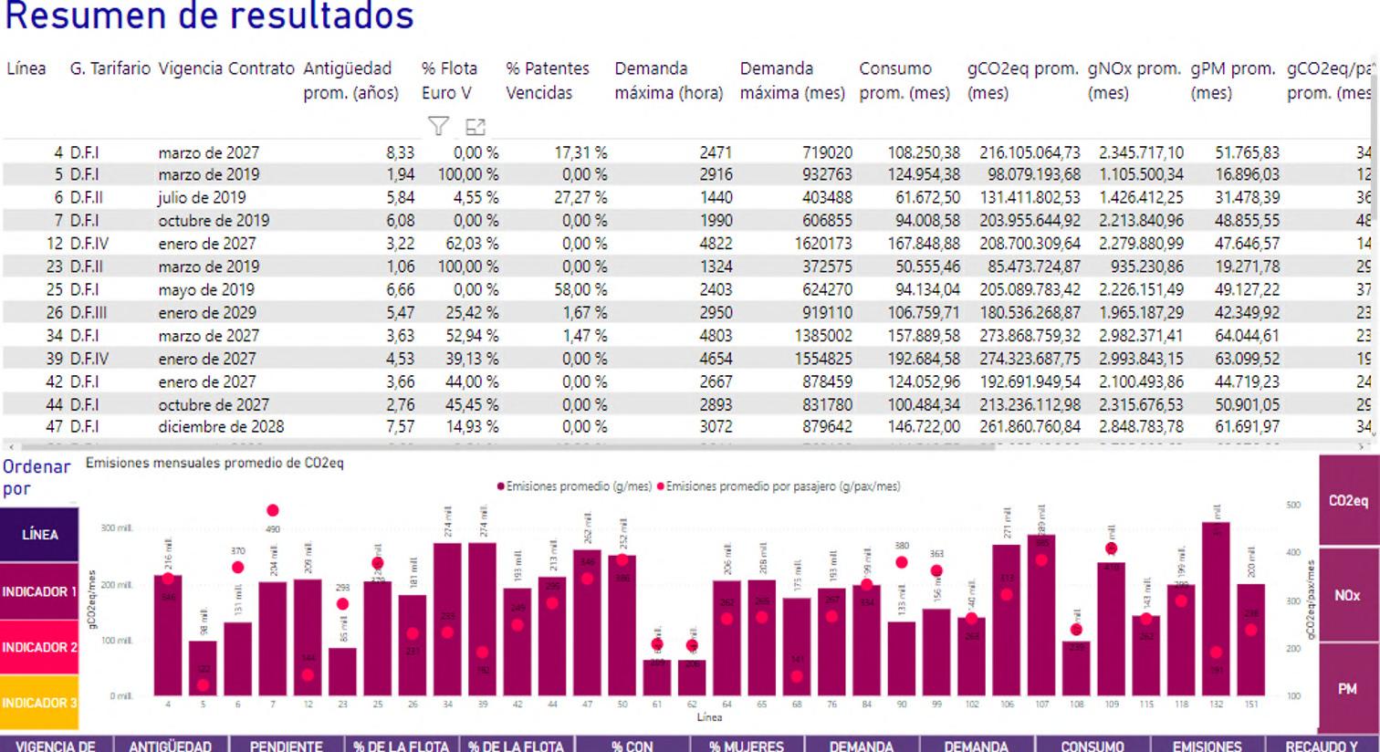
Integral structuring for the electrification of the public bus fleet of the City of Buenos Aires (February, 2021 - December, 2021)
Client: Development Bank of Latin America - CAF Tasks:
•Technical coordination and project management
•Data processing and analysis
•Development of diagnostic dashboard in PowerBI
•Development of a multi-criteria tool for the definition of a bus renewal strategy
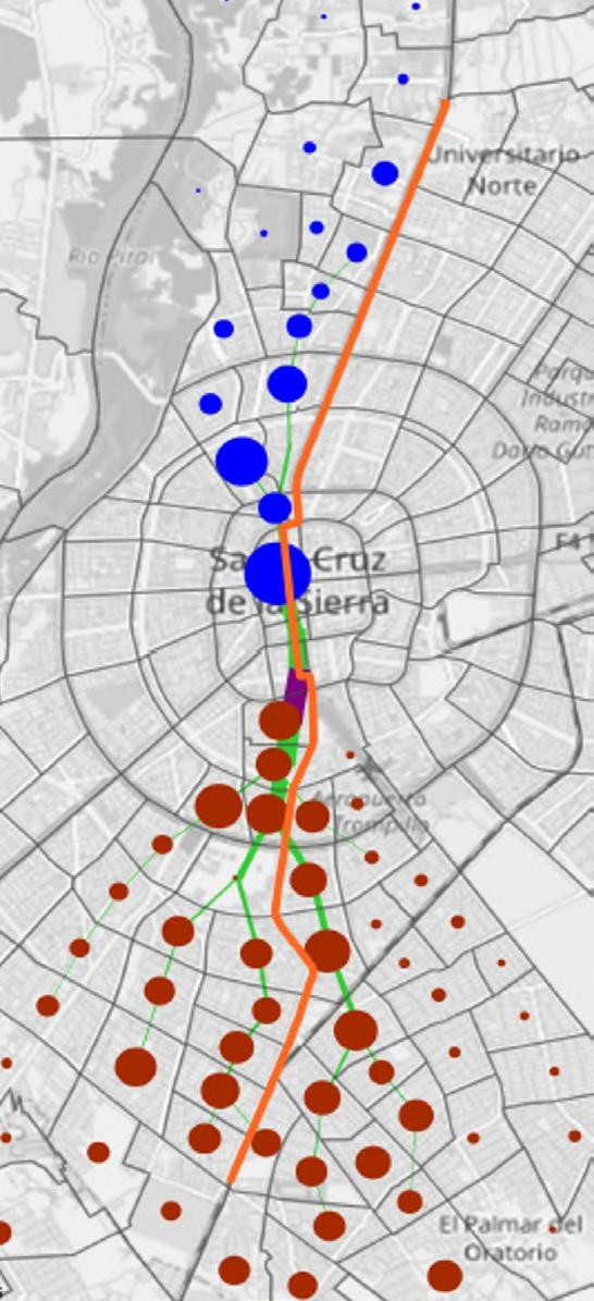
Integral structuring for the operation of Phase 1 of the new BRT Integrated Transportation System in Santa Cruz de la Sierra (January, 2020 - July, 2020)
Client: Development Bank of Latin America - CAF Tasks:
•Emissions analysis of Phase 1A
•Development and deployment of “IDOM Public Transport Planning Tool”
•Development of Service Plan for Phase 1B
Feasibility studies of a strategic plan for an intelligent and inclusive historic center in Santa Marta, Colombia (SANTA SMART-A) (May, 2020)
Client: Financiera de Desarrollo Territorial - FINDETER Tasks:
•Development of algorithm for POIs extraction using Google Maps Places API
•Accesibility and coverage cartographic analysis
ACADEMY AND OTHER PROJECTS
Development of “PTV Visum Public Transport Planning Tool” for visualizing desire lines maps and public transport routes planning (Visum + Python)
Idom Consulting
Extraction of Points of Interest (POIs) using Google Maps and Open Street Maps APIs for land use, event concentration and cluster analysis
Idom Consulting
Generation of isochrones, accesibility and travel time cartographic analysis using Google Distance
Matrix API
Personal project
Web Scraping for data extraction and analysis in real state webpage of Metro Cuadrado in Python
Personal project
Creation of automatization algorithms for sending batch messages in WhatsApp
Personal project
Living the street: a livability assessment of public space from pedestrian perceptions
Civil Engineering Bachelor degree thesis
Universidad de Los Andes
Hyper_street: the extrusion de San Victorino Architecture Bachelor degree thesis
Universidad de Los Andes
Implementing geographically weighted regression models to predict crime rate in function of public space conditions
Institute for Advance Architecture of Catalonia
Open-data pipeline with data collection, network analysis and dashboard developing for mapping the polluting impact of COP28
Institute for Advance Architecture of Catalonia
curriculum vitae
PORTFOLIO

TRANSPORT ANALYSIS DASHBOARDS
KEYWORDS
• GIS ANALYSIS
• DATA PROCESSING &VISUALIZATION
• BUSINESS INTELLIGENCE
TOOLS
• PYTHON-DASH PLOTLY
• R-TMAP
• GOOGLE CLOUD PLATFORM
• MICROSOFT POWER BI
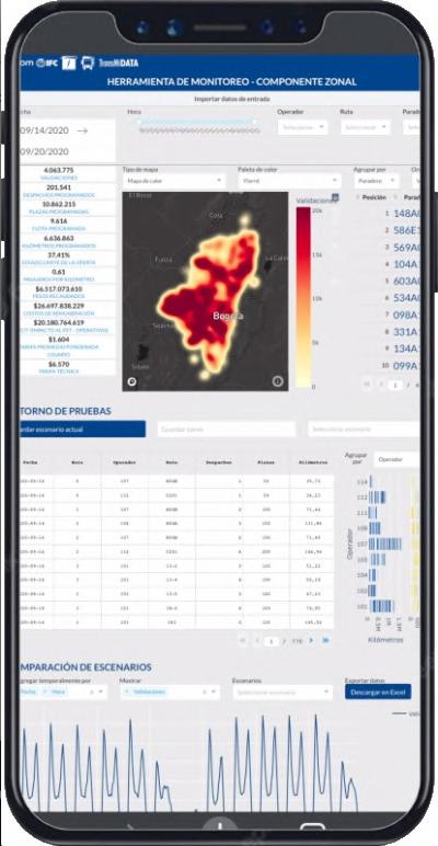
DEVELOPED AT IDOM CONSULING MOBILTY & TRANSPORT AREA
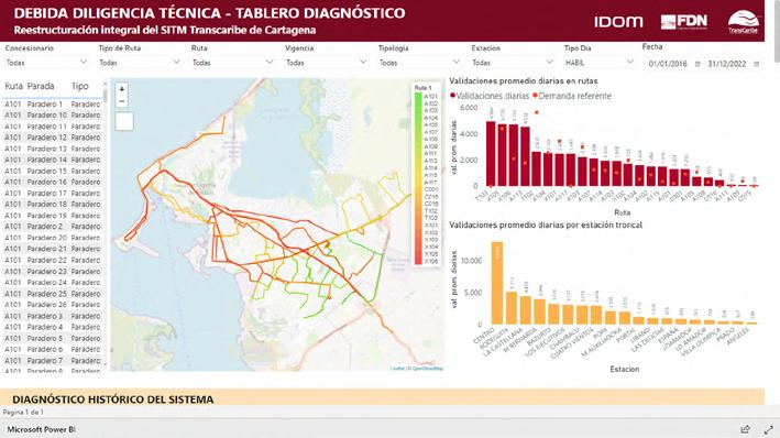
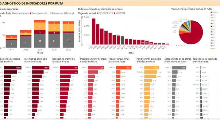
Public transport planning is a discipline that involves an understanding of technical, operational, financial, environmental, social and other related aspects. This implies that the analysis of public transport systems involves an integral vision from each of these perspectives. A series of indicators have been commonly defined both for the early stages of diagnosis and for the monitoring and evaluation of their performance. Each one acquires more or less value depending on the expected analysis.
To this end, several interactive dashboards were developed to allow the characterization of various public transport systems in Latin American cities such as Buenos Aires, Bogota or Cartagena. These have made it possible to understand the historical situation of the systems, evaluate scenarios of changes in demand and supply, allow user filters, and provide data visualization tools in tabular, graphical and cartographic forms.
monitoring dashboard
Bogota, Colombia


diagnosis and operational design dashboards for the for TRANSMILENIO S.A to assess optimization measures post-COVID
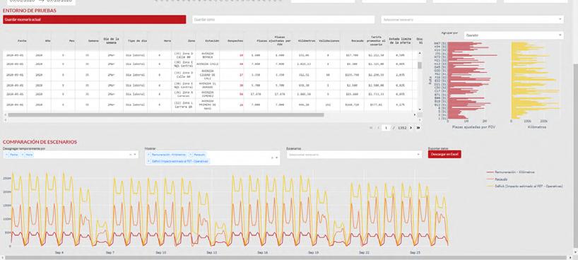
diagnosis dashboard for the Buenos Aires, Argentina
reestructuring of Transcaribe BRT system
Cartagena, Colombia structuring of an electric bus fleet

consulting portfolio

PUBLIC TRANSPORT PLANNING TOOL
KEYWORDS
• TRANSPORT MODELLING
• OPTIMIZATION MODEL
• DATA PROCESSING & VISUALIZATION
• GIS ANALYSIS
• PROCESS AUTOMATION
TOOLS
• PTV VISUM
• PYTHON
DEVELOPED AT IDOM CONSULING MOBILTY & TRANSPORT AREA
Traditionally, travel and mobility patterns can be analyzed through desire lines between origins and destinations. However, in their traditional representation they are often not easily readable and do not show the cumulative flow that defines major corridors.
To overcome these barriers and identify major demand concentrations by corridors within IDOM’s mobility area a tool was developed for visualizing aggregated patterns. This tool was denominated the PTV Visum Public Transport Planning Tool. It allows specific and extremely agile analysis of mobility patterns by mode, purpose, time, and understanding their spatial concentration.
It becomes a useful tool for analyzing dynamic and rapid variations in transportation demand in situations such as the COVID-19 pandemic, making it possible to visualize analysize and identify the main variations in the origin-destination matrices and travel patterns.
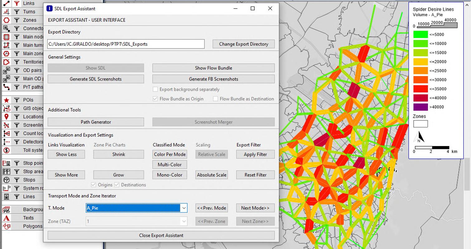


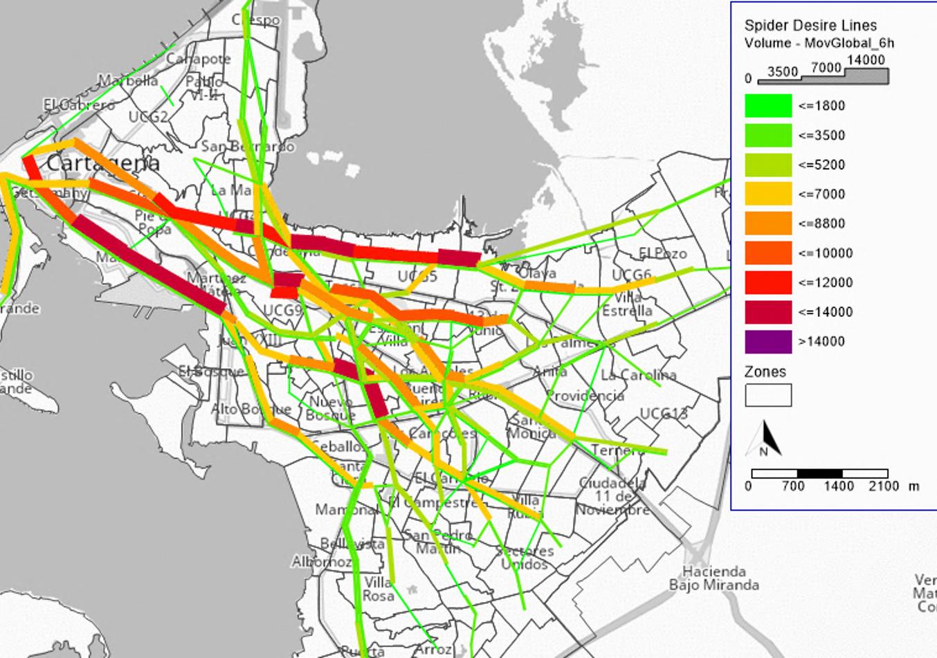
With an intuitive interface, the tool has been used for transportation planning in cities such as Bogota, Cartagena, Santa Cruz de la Sierra or Valencia. It also allows a disaggregation of flows known as Flow Bundle Analysis, to identify the origins and/or destinations associated with a specific zone or corridor. The tool is the enhanced with different mechanisms for exporting images and animations to allow a dynamic explanation of the flows, as well as to allow a variety of display configurations.


Furthermore, through the Path Generator section, the tool runs an algorithm for identifying the optimal routes that would allow to satisfy the most significant demand patterns in the most efficient way.
This is an important planning tool for structuring public transport systems through an optimal operational design and defining route rationalization as well as a diagnosis for assessing existing transport systems in cities.
consulting portfolio
URBAN & NEIGHBOORHOOD STRATEGY FOR
ACCESSIBLE & SAFE SCHOOL ROUTES
KEYWORDS
• URBAN PLANNING
• TRANSPORT PLANNING
TOOLS
• ADOBE ILLUSTRATOR
• RHINOCEROS
• ARCGIS DESKTOP
DEVELOPED AT IDOM CONSULING MOBILTY & TRANSPORT AREA
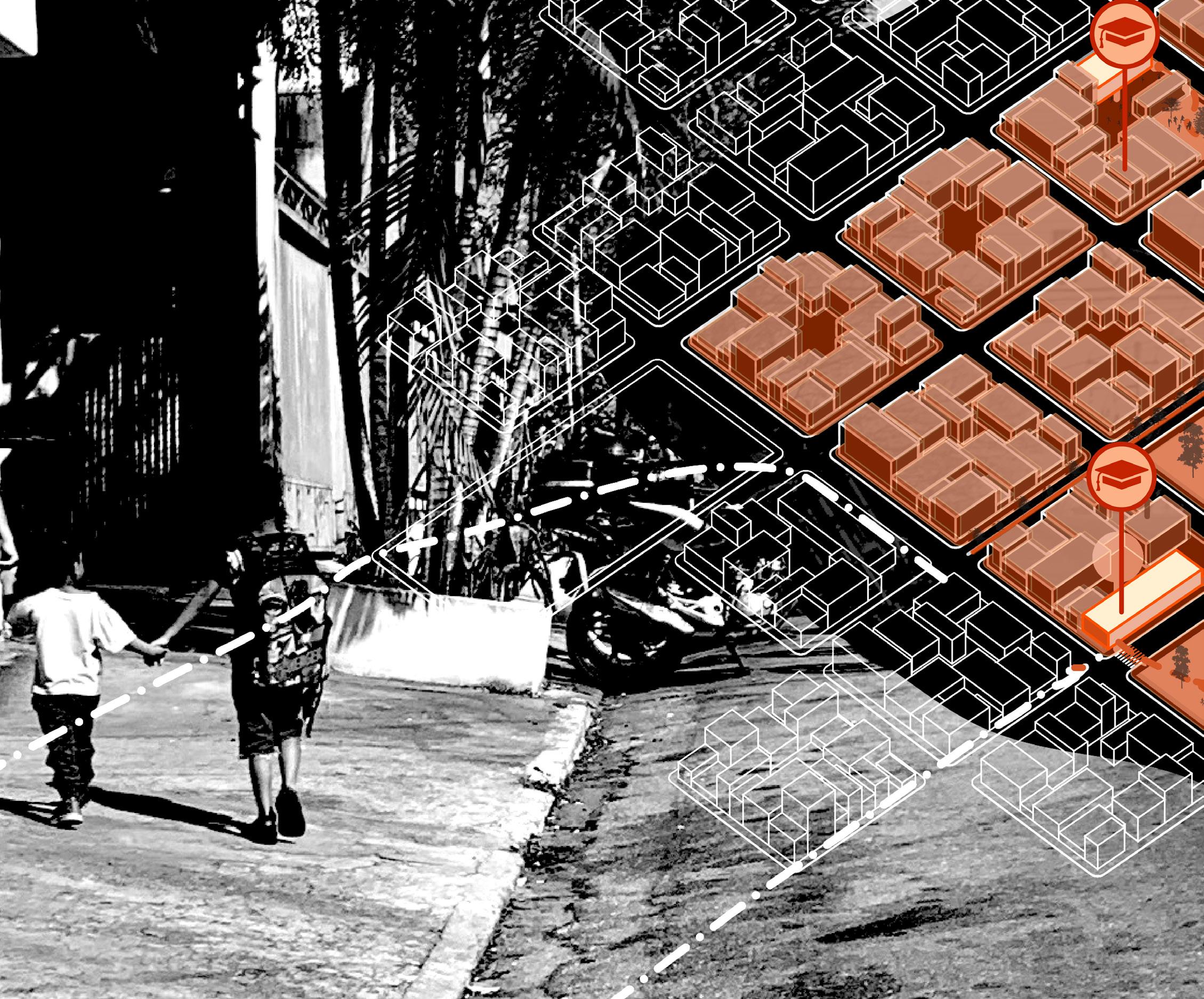
SAO PAULO /BRAZIL
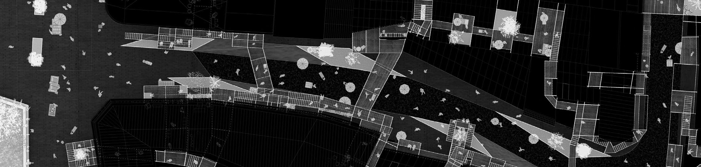
School routes projects aim to stimulate children’s active and autonomous mobility in a safe and accessible way, recovering public space as a place for relationships, play, learning, experience and coexistence. These school routes are developed in the urban environment, on the route between the school and each of the students’ homes, therefore, the environment of the educational institutions and their link with the neighborhood have a great influence on the way they are developed and the mobility patterns that are established.
Recommendations are therefore provided to be considered during the design and conception of a school routes project at the neighborhood scale, including a vision of the urban environment, mobility and community participation and interest. It is important to mention that these actions at the neighborhood scale are necessarily multisectoral and must be aligned with the participation of entities associated with education, mobility, accessibility, among others.
This project was based on an analysis of cases in two neighborhoods in the city of São Paulo, Brazil, Vila Campestre and Vila Carmosina, with heterogeneous contexts that different approaches are needed. The shape of the city can be given in different ways depending on the shape of the blocks and the road network, this can be orthogonal, radiocentric and irregular in the layout. It is important to identify the general characteristics of the implantation of the neighborhood and its urban environment as uncovers the specific challenges and needs in mobility.
most used school routes

Existing public spaces should be connected through the infrastructure of active modes in order to allow safe access by all users. All natural elements that maintain and sustain biodiversity should be identified, whether at the neighborhood or metropolitan level, which can be part of the journey of children and families. If such a network of public and green spaces exists, their connection should be encouraged. The strengthening of a network of public and green spaces brings benefits as it promotes spaces for interaction and developing physical and psycological capabilities in children.
public facilities network

Connectivity with transport systems and the possibility of making the last mile trip safely in active modes must be identified. To do this, it is necessary to identify stations, transportation hubs, bus stops, among other infrastructure that provide access to the city’s public transportation system. This provides the possibility of designing school routes connected to the public mass transit network and therefore mobility patterns of a greater scale, as well as allowing safe and accessible access for users in a variaty of modes of transportation and integration between modes
urban morphology and implantation

Through the reading of the territory, primary data and engagement and listening activities, the routes most used by the school communities in the neighborhood should be recognized.
Identifying travel patterns in the neighborhoods should be the starting point for project proposals, taking into account that the desire lines generated by people generally represent the route that, from their perception, people consider to be the safest, most comfortable, shortest travel time and shortest travel distance.
public space and ecological network
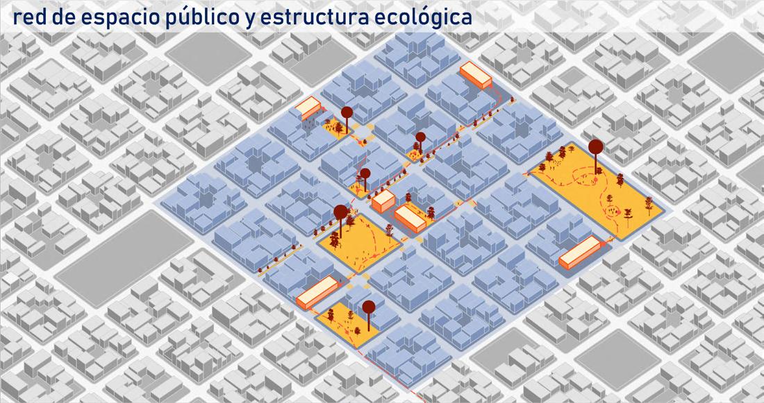
It is necessary to prioritize access to public facilities through active modes, for this purpose, roads and places connected to public space and places with access to public transportation should be prioritized. The location of facilities close to school facilities offers the possibility of finding nearby services. By generating points of interest on the routes, the possibility of activities and partial destinations on the routes between the home and the school are encouraged, promoting centers of permanence that can favor the presence of actors in the public space.
accesibility to public transport

consulting portfolio

LIVING THE STREET
ASSESING LIVABILITY OF STREETS FROM PEDESTRIAN PERCEPTION
KEYWORDS
• PUBLIC SPACE
• PEDESTRIAN PERCEPTION
• ETNOGRAPHIC APPROACH
• STREET LIVABILITY
• BIBLIOGRAPHIC RESEARCH
• ENVIRONMENTAL PSYCHOLOGY
BOGOTA /COLOMBIA
Public space is increasingly becoming a matter of interest for designers and planners, because, apart from being the means through which citizens mobilize, it is also the main scenario for developing life in society.
For this reason it is considered as an space that needs to be livable. Besides, it is recurrent to find literature that states the importance of assessing the livability of public space from the perception of users.
For this reason, this research performs a bibliographic review of the different definitions and components of street livability from its physical, phenomenological-functional and user-perception dimensions. Furthermore, it is necessary to carry out an ethnographic approach through interviews performed to users that inhabit the public space of Bogota, Colombia, looking forward to evidence the variables that are important to users when choosing a public space to stay. This allows to compare the definitions and components found in the literature and the results obtained in field interviews from user perception.
academic portfolio
The implemented methodology led to the identification of variables that are mentioned in the literature such as the existence and availability of places to sit, presence of vegetation, absence of noise, presence of food and drinks vendors, the perception of safety, maintenance and tranquility in the public space, as well as variables that were not found in the literature but were recurrently mentioned in the interviews such as the closeness to origins and destinations.

“I wanted to take a break before getting in the car (...). I usually do this, not necessarily right here, but somewhere quiet.”
Woman between the ages of 20 and 35 sitting taking a break after lunch.
“I’m on my day off, so I like to sit and rest (...). I like to sit in a park more, with the open air and nature you feel more motivated.”
Man between 50 and 60 years old sitting resting.
“Here I feel comfortable and I can get back to work quickly.”
Man between 20 and 35 years old sitting taking a break after lunch before going back to work (occupation: doorman in nearby building).
“We come here because it’s a different space from home. Even though I feel good at home, I couldn’t have all this vegetation.”
Two women between the ages of 20 and 35 sitting on bench talking.
“I have to take [an older man] out for a walk, to see people. This is a quiet place, where he can clear his mind.”
Woman in her 20s and 35s and older man in his 60s resting.
“It’s the closest thing there is to have a beer.”
Man and woman in their 20s and 35s sitting drinking beer while their pet is lying on the grass on top of the sill.
main reasons to inhabit activities performed in public space public space

The results allow to restate the importance of considering users perception as a fundamental variable for designing public space and evidence the flaws in the methodologies that are currently used for designing and recovering public space in the context of Bogota, by basing in objective indexes rather than subjective ones such as user perception. From the development of this study it is possible to evidence the need of expanding the usage of quantitative methodologies and considering perception variables to assess the livability of public space and as tools for public space design and planning.

HYPER_STREET
KEYWORDS
• CLUSTER ANALYSIS
• PUBLIC SPACE TOOLS
• RHINOCEROS
• PYTHON
• GOOGLE MAPS API
• ARCGIS DESKTOP
• ADOBE PHOTOSHOP
• ADOBE ILLUSTRATOR
• ADOBE INDESIGN
• ADOBE AFTER EFFECTS
BOGOTA/COLOMBIA
In the heart of Bogota, a city of limits, in which it is increasingly common to drive people away from the streets, there’s a place that stands out for doing absolutely the opposite: San Victorino is a commercial cluster within this immense city in which the imposition of its own rules take over the entire space. Tides of vendors, buyers, commuters and visitors invade the surface. The architecture suddenly blurs behind layers of products and merchandise. The hyper_street takes these elements that synthetize the essence of San Victorino and extrudes them through space and time, allowing the commercial activity, that is currently completely dependent on the activity of the ground floor and its time slots, to link the upper floors, attract new actors and inhabit the public space in the different temporal scales and scenarios. The value of this project lies in the way to create an urban system that evolves and adapts at the pace of San Victorino; it is an architecture that ends up in a secondary plane allowing the image of the place to be completely visible and exalted.
THE EXTRUSION OF SAN VICTORINO


In San Victorino, today, there is a total appropriation of the street. The commercial activity of the ground floors extends along the facades, along the sidewalks, along the road. Its inhabitants, buyers and sellers impose their own order that ends up taking over the entire space. However, if San Victorino was left in the hands of the city makers, the decision makers, its commercial character would be used and exploited in its economic sense, keeping people away from the public space, enclosing the life that belongs to the street.
By implementing the hyper_street in a cluster such as San Victorino, the objective is to propose an architectural project that can develop at the pace of the dynamics of the place. This can be the scene of all the temporalities that pass through San Victorino, being truly a space that captures the passage of time.


The true value of this project lies in being a seed for a system that can grow as people take ownership of it. It is an architecture that is posed to take a back seat, being colonized and harnessed by its inhabitants, hidden behind layers of products, transformed in time and space as San Victorino changes.
The ultimate goal of the project is to allow the dynamics of the place to be fully legible; that the scenes that take over its streets can not only continue to exist but take over the entirety of the empty space.


what
san
shouldn’t be victorino
it is now
what it
academic portfolio

HYPER_MOVEMENT
KEYWORDS
• FORMAL EXPLORATION
• PARAMETRIC DESIGN
TOOLS
• RHINOCEROS
• GRASSHOPPER
• ADOBE PHOTOSHOP
• ADOBE ILLUSTRATOR
• ADOBE INDESIGN
• ADOBE AFTER EFFECTS
THROUGH SAN VICTORINO
BOGOTA/COLOMBIA
San Victorino, as a commercial cluster in the heart of Bogota, brings together a very intense and varied dynamic of activity. The identity of the place was sought to be represented through various formal explorations. Using advanced modeling and representation techniques (solid projections, image extrusions, remapping, image manipulation, data collection and post-production techniques) we sought to synthesize the essence of San Victorino.
San Victorino is pure movement, there the mass of passers-by mixes with the colorful facades hidden behind articles, clothes and other merchandise. The philosophy of projecting on the territory is also materialized as an object, demonstrating how pedestrian flows extend and infiltrate the neighborhood and extrude into three-dimensional space and time, diluting the border between architecture and the street, between above and below, between the public and the private. The different experiments and iterations are exposed as follows.

self_materiality:

Architecture must adhere to movement, it must cease to be static and disintegrate into its solid condition, it must flow in time and allow for change, uncertainty, unpredictability, all of which are inherent to the human experience. “Movement is an undivided fact, or a series of undivided facts, whereas the trajectory is infinitely divisible.” Bergson, H. (1896)

complexity_&_diversity:
The urban system that arises acquires meaning when it is linked to the movement of people and the passage of time. Thus, the route is materialized, and the lines of desire left by the trail of pedestrians become explicit in space. This gives the system its power to be an element of San Victorino and the way it is inhabited by its visitors.

hidden_materiality:

The mass has no structure other than movement. The currents that circulate through the void give form to the mass, just as they dissect it, dilute it, fade it. Up and down, front and back, before and after, in and out, are opposites that begin to lose meaning. Up and down, before and after, full and empty, are opposites that start loosing meaning.

hyper_objects:

Public life in San Victorino takes over the street in its entirety. Crowds flood the surface filling the void with textures, colors, smells, sounds, people and products. However, this surface acquires thickness and assembles this system that connects the above with the below; the inside with the outside. It extrudes in height filling up the tridimensional space.
academic portfolio

THE ARMATURE CONSTELLATION
LANDSCAPE & URBAN PLANNING IN THE NORTH OF BOGOTA
KEYWORDS
• LANDSCAPE ARCHITECTURE
• URBAN PLANING
• URBAN FOOTPRINT
• WATER MANAGEMENT
• URBAN DESIGN
TOOLS
• ARCGIS DESKTOP
• ADOBE PHOTOSHOP
• ADOBE ILLUSTRATOR
• AUTOCAD
BOGOTA /COLOMBIA
Bogota is a city in constant growth. Its urban footprint is expanding exponentially, covering more and more area. At the north, the capital of Colombia borders municipalities such as Chía and Cota, which are increasingly involved in the activities of the metropolis. There, a growing urban development coexists with an increasingly fragmented ecological structure. By attaching the activities of the metropolitan area it generates the urban pressure of 1.000.000 new inhabitants.
The armature constellation proposes a strategy to reconnect the great axes that form from the Eastern Cordillera to the Bogotá River in the west through the green surfaces that infiltrate the neighborhood scale. It also seeks to connect the waters that flow down from the mountains through wetlands, canals and other bodies of water until they reach the waters of the Bogota River, as well as to allow the treatment of water on soft surfaces in urban environments, allowing infiltration into the subsoil through biofilters and biomachines.


This idea is developed through four strategies:
• A inhabitable meander, for water and humans to meet, where sediment and permanence are hosted.
• A refuge to house humans and birdlife, where one sings and flies while the other contemplates, where they can protect themselves from the sun or rain.
• A riverside where passers-by can circulate in the direction of the water while generating pockets for people to inhabit and vegetation to emerge.
The flood zone of the Bogotá River is invaded by crops and informal settlements. This leads to the occurrence of major disasters when the water level rises. To counteract this, it is possible to imagine a river bank with flexible habitable spaces that can adjust to the water levels of the river so that, when the water rises, they are floodable land, but when the water falls, they can accommodate soujourns and journeys. This generates new spaces that can be inhabited both by humans and water.
the meander water & men

the refuge birds & men
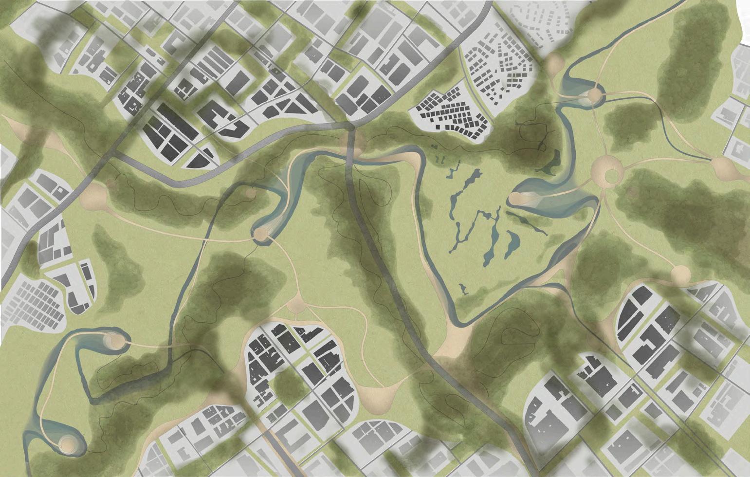
• A thicket, which serves as a buffer to protect the ecosystems from urban density and infrastructure and allows a diversity of species, including humans, to get lost and explore the tree-lined paths, to serve as a transition between the neuralgia of the city and the calm of the natural landscape.

the riverside opposing shores

the thicket dilator & conduct

the avifauna corridor MAJUY MOUNTAIN BOGOTARIVER CERROS ORIENTALES PARAMO BOGOTARIVER SHORE GUAYMARALAIRPORT BIMA OUTLET REECREATIONPARKS MOUNTAINTRAILS
MOUNTAIN BOGOTARIVER GOLFCLUBS CONEJERAMOUNTAIN GRAVEYARDS WETLANDS HIGHWAY HIGHWAY CERROS ORIENTALES
MAJUY
academic portfolio

COMPOSING
THEREM KOOLHAASWAY BOGOTA /COLOMBIA
KEYWORDS
• REM KOOLHAAS
• COMPOSITION LAB
• MIXED USES
• SKYSCRAPPERS TOOLS
• RHINOCEROS
• ADOBE PHOTOSHOP
• ADOBE ILLUSTRATOR
• AUTOCAD
• ARCGIS DESKTOP
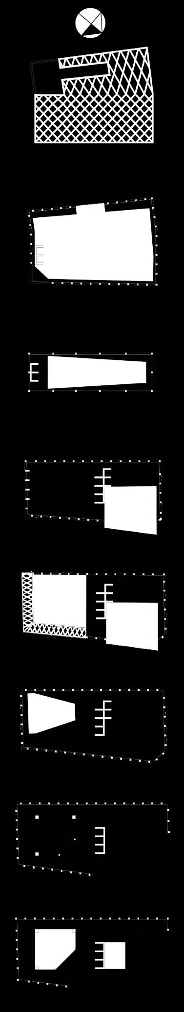
To compose in the manner of Rem Koolhaas is to learn to appreciate the movement of cars, the noise of the city, chaos, emptiness, monumentality and freedom in an explicit way. His theorems demonstrate a contemporary approach, where the vertical city becomes the protagonist, and with it a monumentality referenced to greatness. Thus, the idea of the skyscraper as the metropolitan building par excellence arises, with the need to understand circulation, no longer as an architectural but as a mechanical element.
The core is separated from the envelope, to the point that the latter hides the interior activity from the exterior. However, the public space begins to rise and the project ceases to respond to its immediate physical context, the form moves away from the program, and the void becomes the guiding thread of the project. Extrusion appears as the a priori step of the composition to make reference to the norm, and is progressively distorted until it results in a project alien to what its implementation would show.
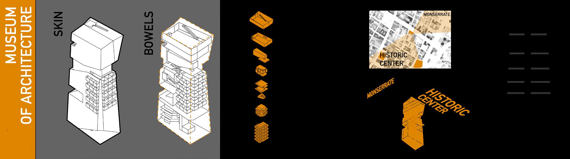
This translates into a highly experimental design exercise. In a neuralgic corner of downtown Bogota, where rivers of people, traffic jams, commerce, industry and noise converge, just a few blocks from the foundational center of the city, and at the foot of the hills of Monserrate and Guadalupe, a hybrid building for an architectural museum rises. First of all, it must respond to the urban dynamics that converge there, giving rise to the concern to “break the corner” and thus bring passersby inside and elevate the public space vertically. For this reason, the first operation to be carried out is to extrude the lot twenty-two stories upwards.

In addition, by accommodating such a diverse program, concerns begin to arise seeking to satisfy the sensory experiences of the particular spaces, leading to the distortion of the envelope: the view in the Colombia Room is oriented towards the historic center and Monserrate as icons of the capital and the country; in the World Room, the view is directed towards the sky, towards the outside world. On the other hand, there is a tower of 30 apartments that rises from the first floor to separate them from the public space. Additionally, the spatial heterogeneity added to the height of the building calls for an unconventional structure. Therefore, the braced façade and fixed point cores are used as the elements that distribute the load path.

academic portfolio