

JOEL SAMUEL
Architecture Portfolio
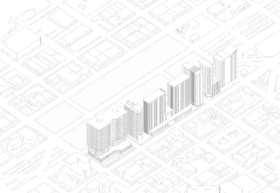
THE BAYWARD
A Mixed-Use Community in the Heart of Oakland
Located on the southern perimeter of Old Oakland, The Bayward is a charming and affordable mixed-use development where opportunities flow in abundance and embraces community to empower local residents. This development’s sustainable and resilient infrastructure encourages social and economic advancement in Oakland through its four key elements: revitalization, community, equity, and conservation. This master plan introduces multiple apartment towers that will command a powerful visual to the Old Oakland skyline. The center of the development yields a new pedestrian corridor, known as the Clay Promenade. Economic growth in the area will occur through the development of new office and retail spaces and a satellite campus for Laney College that will supply just over 5,000 jobs. In addition to jobs on-site, the campus will produce new job candidates for the region through traditional education and training catered towards trades with professional licenses.


Bay ward THE

Site Streets Site Boundary


1
Street Bioswales
Bioswales allow for the collection, conveyance, ltration and in ltration of stormwater for its later use throughout the site reducing runo and sewer over ows.
3 Parking Garage with EV parking spots, e-bike and e-scooter racks, and ride-share drop-o /pick-up spots
4 Community center with classrooms, a public computer lab open from 8 AM - 12 AM, and soup kitchen that serves food everyday of the week at 7:30 PM
Pervious Street
Pervious concrete reduces the need for separate stormwater retention ponds and allows the use of smaller-capacity storm sewers. It also reduces runo volume by trapping and slowly releasing precipitation into the ground.
Landscape Zones Building Program


Roof Solar Panels
Using 80% of the roof area, the site will implement the use of solar panels as the main source of energy. Solar power is pollution-free and causes no greenhouse gases to be emitted after installation as well as reducing the dependence on foreign oil and fossil fuels.
Green Roofs
Green roofs throughout the site will provide shade, remove heat from the air, and reduce temperatures of the roof surface and surrounding air. They will also reduce stormwater runo and be part of the roof rainwater collection system.

Abraham A DAY IN THE
Abraham has lived in Old Oakland his entire life, but a series of unfortunate events has left homeless for the last three years. He utilizes social program services offered at the community college.
Paul
Paul stops by the Clay Promenade on his way home after working at his office job. He finds entertainment in the various activities that takes place every day and takes a moment to enjoy them while he waits for his bus.
Nancy and Isabelle
As a single mother, Nancy frequents the grocery store and farmer’s market that takes place every week and is able to provide Isabelle with healthy meals.
Katherine
Katherine has yet to find a job two months after she has graduated from the local community college, but she’s optimistic about her future as she finds security in her affordable rent and in her degree in a rising industry.
SEASONAL CALENDAR


Bayward Master Plan Designed in Collaboration With:

Megan Do

https://www.linkedin.com/in/megando97/
Gassan Nasr
https://www.linkedin.com/in/gmnasr0703/
Yelena Vieyra
https://www.linkedin.com/in/yelena-vieyra-351b33174/
ASTROGREEN
A Mixed-Use Community centering The Astrodome
This proposal aims to bring back the iconic quality of the historic Houston Astrodome by making it the central focus of a new walkable mixed-use community. In order to achieve this goal, a radial pedestrian paseo system was designed which was superimposed on to the orthogonal street grid system, which is intersected by a grand central greenway. The radial pedestrian paseo system and organization of major streets ties back to the original intended site plan for the Astrodome & the surrounding NRG park. The addition of a large central greenway provides a connection to the Brays Bayou Greenway regional Hike & Bike trail system, and together with the central plaza areas, create large gathering spaces for activities for events such as the rodeo and other world-class events.


Astrodome
Astro-Greenway


Highlighting The Astrodome


The new Greenway provides unobstructed views from the North along Brays Bayou and from the South on the Loop 610 Freeway as well as from West Bellfort Avenue. We used the organization of the building heights to guide attention towards the Astrodome and to also tie in the NRG stadium into a larger urban fabric that elevates and highlights the Astrodome instead of overshadowing the astrodome as it currently does now.

Sustainable Development Strategies


Astrogreen Master Plan Phase
Designed in Collaboration With:
Christopher L. Blahuta
https://www.linkedin.com/in/chris-blahuta-eb14wc17uh22/
Gassan Nasr
https://www.linkedin.com/in/gmnasr0703/
Yelena Vieyra
https://www.linkedin.com/in/yelena-vieyra-351b33174/
Cyndi Cheng
https://www.linkedin.com/in/cyndi-cheng-954666200/
The 2nd phase of the Astrogreen Project consits of the development of 5 catalyst blocks within the site. Each team member will choose one to focus on and design on their own, as well as developing program, design, and implementing net-zero strategies. My Catalyst project consists of the two greenway blocks just north of the Astrodome.


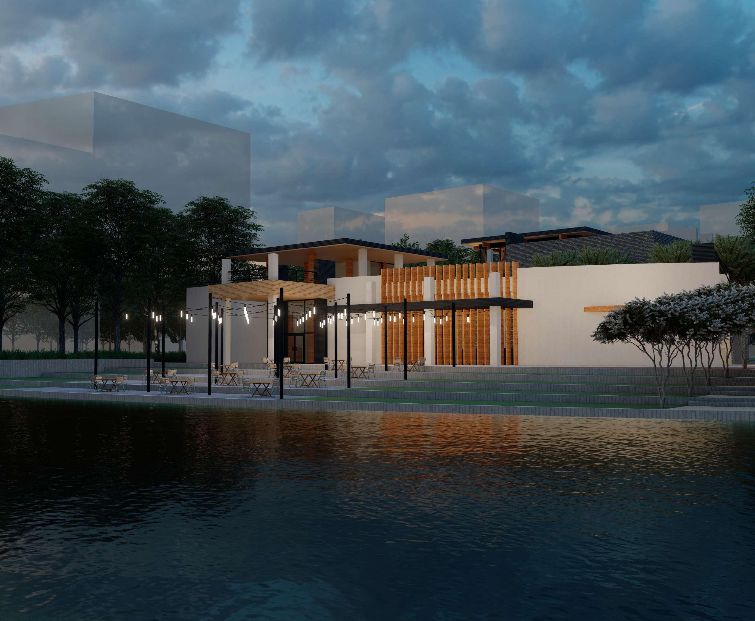
The Crossroads
The Crossroads On The Green
A Vibrant Park & Visitor Center for The Astrogreen
Imagine a lively outdoor concert as part of the many festivities during the Houston Livestock show & rodeo or a romantic date night at a trendy fusion-concept restaurant, or even a refreshing morning jog during the few days in the fall when the weather is just right. These are some of the various activities that would take place at The Crossroads on the Green; a vibrant neighborhood & regional activity center located in the heart of the Astro-Green Greenway. Some of the features of the park include a spacious event lawn & adjacent performance pavilion, play areas, a visitors center, and an anchor restaurant. The Crossoroads takes up a sizeable portion of the AstroGreen’s central greenway with the Heart of the Crossroads located at the intersection of the Greenway and the Main Paseo Loop. The neighboring buildings along this section of the Greenway are lined with ground level retail facing the greenway as well as a school & community library along Emmet St. both sides.


Structural System
Mass-Timber
Structural Members
Concrete
Structural Members

Outdoor Bar Visitor Center

Concrete Load-Bearing Walls
Sustainable Strategies
Building Structure
Buildings


Rainwater Collection

Houston Exploration Center
Public Library Project
Located in the Rice Military neighborhood in Houston along Buffalo Bayou Park, the HEC is envisioned as a library with multiple goals, ones that rebrand traditional functions of a library and hybridizes them with those of a community outreach center. This new community node is a learning facility where knowledge, and its acquisition, is the primary product. That product may be conveyed in the conventional transmission of knowledge through reading or in the communicating of events, both historical and contemporary, by means of presentations, and outreach efforts led by local organizations.

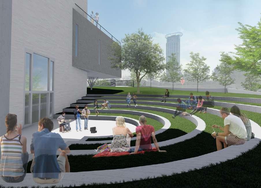
Community Promenade


The site design centers the library as a community node with elements of the site tying into the Rice Military/Washington Corridor neigborhood & Buffalo Bayou Park. The existing pedestrian bridge and path will be rebuilt to allow for more space and to tie into the future bike lanes proposed for Jackson Hill Street. Due to steep slope caused by the ground behind the bridge, a small outdoor ampitheater was incorporated to prevent soil erosion onto a new community promenade as well as providing additional outdoor space for library programs. The existing B-Cycle station would be rebuilt into the intersection of the bridge path and the new promenade. As part of the project requirements, this community promenade will be incorporated as an extension of Scotland Street for pedestrian use. It will be closed off to vehicular traffic, but it will be wide enough to accommodate food trucks and deliveries. An additional offshoot promenade will be added that would allow a pedestrian connection to the parking lot on the Northeast side of the site as well as future mixeduse developments along Waugh Drive. The main entrance of the library will be located at the intersection of the two promenades. The cafe will be seperate from the library on the Northwest corner of the promenade intersection so that it can operate seperate from library hours. The parking lot can be accessed by the Waugh/Memorial westbound ramp or by Jackson Hill Street via an extended driveway from the DX Holdings parking lot. The Northwest corner of the site will remain as a forested area. The space between the parking lot and the main promenade will be turned into a amenity retention pond as the topography causes water to flow into an existing drain at that spot as it is lowest point on the site.


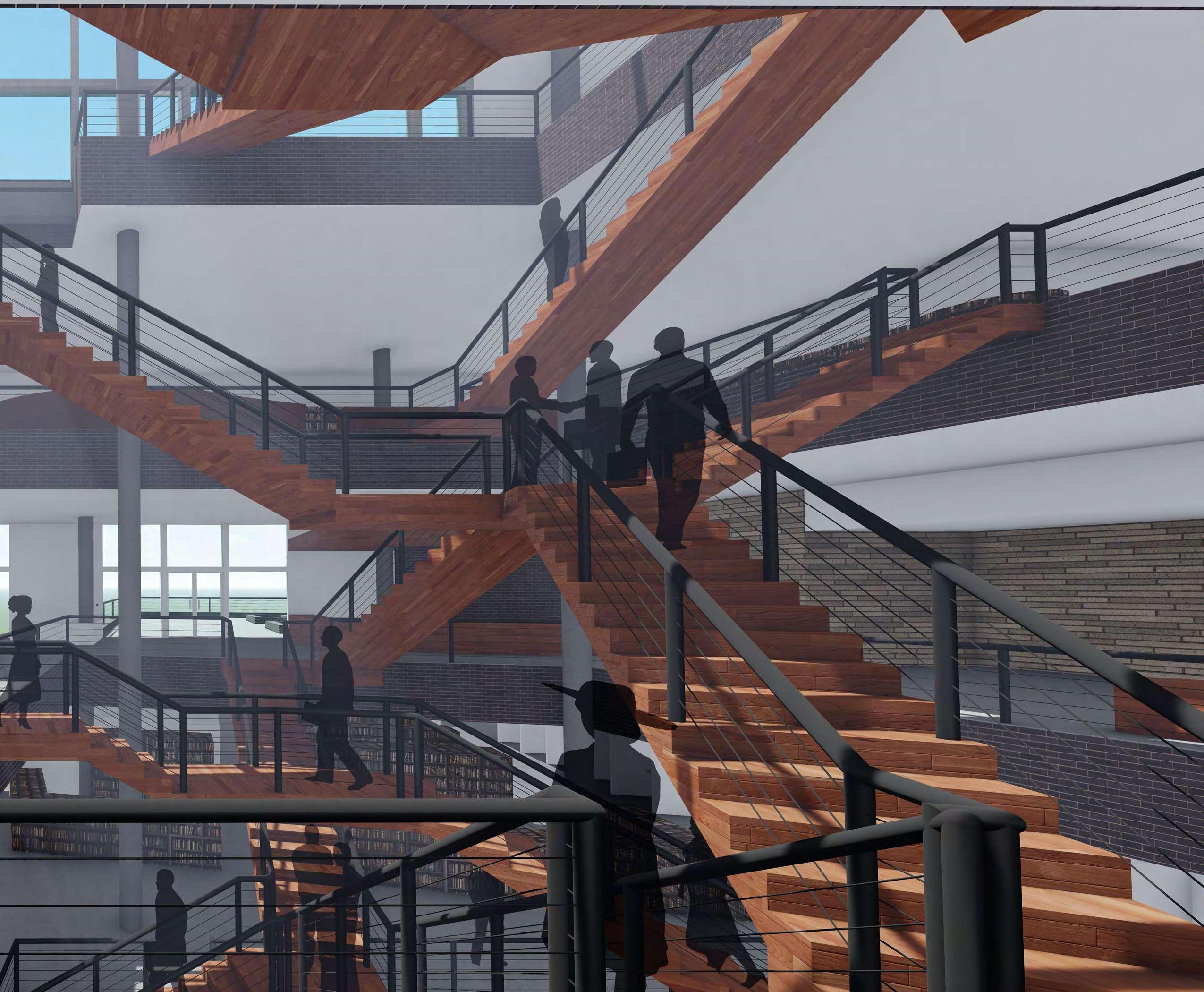
The central atrium and public spaces around it act as a community core, linking the various levels of the H.E.C. with the outdoor promenades that branch out into the community. These spaces can accommodate civic-based organizations such as educational and civic groups, galleries and volunteer organizations that can reserve locations for pop-up exhibits and events to promote various activities and causes. Within the atrium, there is a vast system of intertwining, branching stairs connecting the various floors of the H.E.C. to promote interaction between visitors.

Atrium Stairs

South Elevation

West Elevation
Exterior Materials


Randers Tegl


Elevation Render

Buffalo Bayou Park View


Eroded
The Link at Galveston
This proposed project would act as a “link” between the hotel & restaurant development along the harbor, and retail along the historic Galveston Strand. Currently the site is a parking lot between Harborside drive & Pier 21, but the city hopes to redevelop it in the future. The project would include an outdoor market & a music venue with an attached restaurant. After visiting the site and doing research on Galveston, the process of erosion stood out to me as it affects Galveston on many scales. From the rough eroded facades of historic buildings to the formation of the island itself, erosion plays a major role in Galveston. The concept of Erosion was incorporated into this design with a thick exterior brick facade that can erode down over a long period of time, revealing newer, inner layers. The interior of the building would consist of a large, smooth cavernous space, with large skylights located at the ends of the building.


The form of the building is derived from the pedestrian activity patterns of the site, in which areas of high pedestrian activity would slowly erode away the edges of the site to reveal a smooth, organic form. Much of the pedestrian activity happens on the Northwest side of the site due to being directly adjacent to Pier 21. The open space on that corner of the site will be reserved for the outdoor market. The building’s structure will consist of large arching trusses. There will be two light concrete shells that will be held up by the trusses; an outer shell that will rest on top of the trusses, and an inner shell that will be suspended from them. The outer shell will be concealed as it will hold up the exterior brick layers, while the smooth inner shell will remain exposed
South View

Section B
The form of the building is derived from the pedestrian activity patterns of the site, in which areas of high pedestrian activity would slowly erode away the edges of the site to reveal a smooth, organic form. Much of the pedestrian activity happens on the Northwest side of the site due to being directly adjacent to Pier 21. The open space on that corner of the site will be reserved for the outdoor market. The building’s structure will consist of large arching trusses. There will be two light concrete shells that will be held up by the trusses; an outer shell that will rest on top of the trusses, and an inner shell that will be suspended from them. The outer shell will be concealed as it will hold up the exterior brick layers, while the smooth inner shell will remain exposed .The form of the building is derived from the pedestrian activity patterns of the site, in which areas of high pedestrian activity would slowly erode away the edges of the site to reveal a smooth, organic form. Much of the pedestrian activity happens on the Northwest side of the site due to being directly adjacent to Pier 21. The open space on


Joel J. Samuel
713-885-5669

jsamu53043@gmail.com
linkedin.com/in/joel-samueljsamu53043
