inkl. 3 schuhroutenSchnee-incl. 3hikessnowshoe
Schwierigkeitsgrad
level of difficulty
Gehzeit
walking time
Distanz distance
leicht easy mittel intermediate schwierig difficult
Paznaun
Galtür Ischgl
Kappl | See
Beschilderung/ Signage Winterwanderweg
Schneeschuhroute


Kappl, Bergstation Diasbahn
Kappl, Dorf
Kappl, Mittelschule


See, Talstation Medrigjochbahn
See, Bergstation Medrigjochbahn
See, Bergstation Zeinisbahn
W.01
WEISSE WEITEN
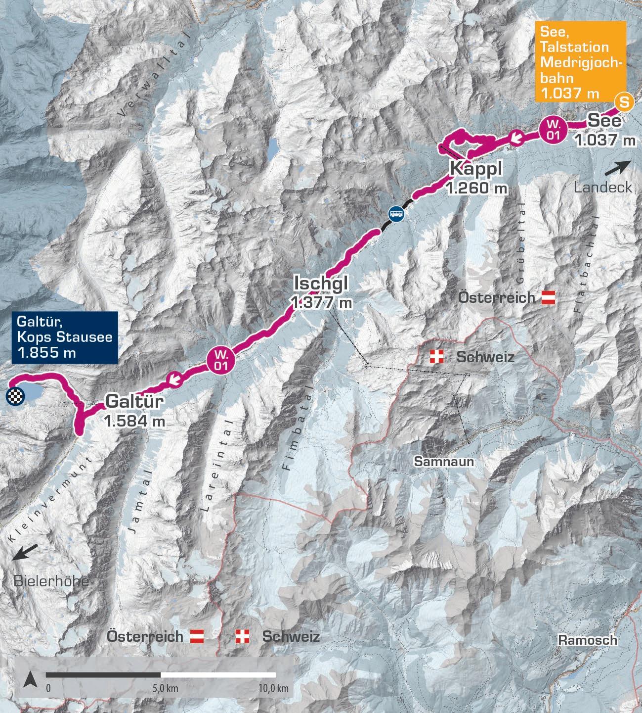
Der Winterweitwanderweg „Weiße Weiten“ erstreckt sich über 52,7 Kilometer von See bis zum Kops Stausee in Galtür und durchquert das gesamte Tal in drei Etappen. Die Route führt durch atemberaubende, verschneite Berglandschaften und bietet eine leichte, aber konditionsfordernde Wanderung für naturbegeisterte Wanderer. Dieser Weg verspricht ein unvergessliches Wintererlebnis mit malerischen Ausblicken, die jeden Naturliebhaber begeistern werden.
The „Weiße Weiten” (White Vistas) winter long-distance trail covers 52.7 kilometres from See to the Kops reservoir in Galtür, crossing the entire valley in three stages. The route takes you through breathtaking snow-covered mountain landscapes, offering an easy but physically demanding hike for nature-loving walkers. This trail promises an unforgettable winter experience with picturesque views that will captivate any nature enthusiast.
Start | start: See, Talstation Medrigjochbahn
Ziel | destination: Galtür, Kops Stausee
Einkehrmöglichkeiten | rest stops: Restaurants auf der Strecke | restaurants at the route
Schwierigkeitsgrad level of difficulty
mittelschwierig | intermediate
Gehzeit walking time 14 h (6 h | 5 h | 4 h)
Distanz distance 52,7 km (15,9 | 18,8 | 18)
2.000 m
1.800 m
1.600 m
1.400 m
1.200 m
1.000 m
See, Talstation Medrigjochbahn 1.037 m Galtür, Kops Stausee
1.1 DER NATURVERBUNDENE WINTERWANDERER
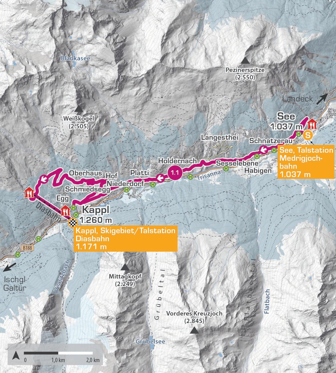
Die erste Etappe des Winterweitwanderwegs von See nach Kappl ist ein Highlight für Naturfreunde. Die 15,9 Kilometer lange Strecke beginnt an der Talstation der Medrigjochbahn in See und führt über den malerischen Weiler Oberhaus ins Skigebiet Kappl. Gemütliche Hütten laden unterwegs zur Rast ein. An der Bergstation der Diasbahn kannst du entscheiden, ob du mit einem Snooc (Sitz-Ski) oder der Gondel ins Tal fährst. Einen Snooc kannst du gegen Gebühr im Sunny Mountain Restaurant ausleihen.
The first stage of the winter long-distance trail from See to Kappl is a highlight for nature lovers. The 15.9-kilometre route starts at the valley station of the Medrigjochbahn in See and leads through the picturesque hamlet of Oberhaus into the Kappl ski area. Cozy lodges along the way invite you to take a break. At the mountain station of the Diasbahn, you can choose to descend into the valley by Snooc (a sit-ski) or by cable car. You can rent a Snooc for a fee at the Sunny Mountain Restaurant.
Start | start: See, Talstation Medrigjochbahn
Ziel | destination: Kappl, Skigebiet/Talstation Diasbahn
Einkehrmöglichkeiten | rest stops: Restaurants auf der Strecke | restaurants at the route
Schwierigkeitsgrad level of difficulty
mittelschwierig | intermediate
Gehzeit walking time 6 h
Distanz distance 15,9 km
2.000 m
1.600 m
1.200 m
800 m
1.2 PANORAMATOUR DURCH ISCHGL
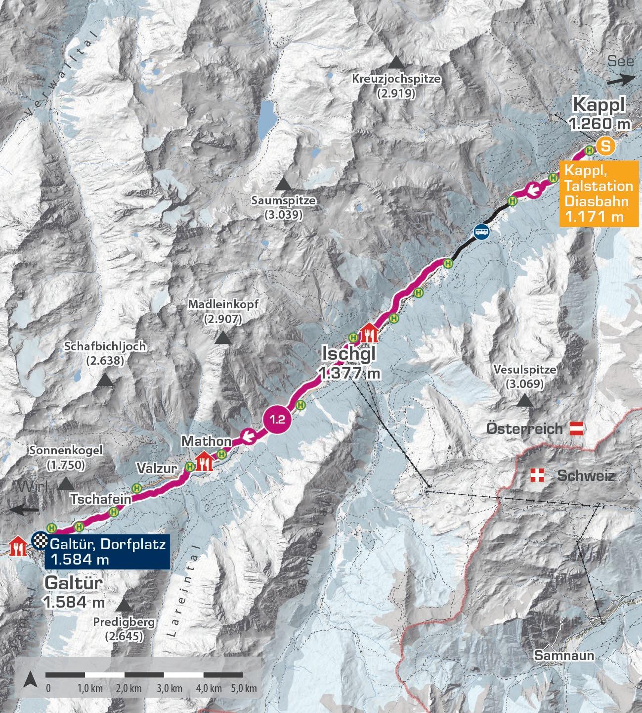
Die zweite Etappe, 18,8 Kilometer lang, startet an der Talstation der Diasbahn und führt durch das idyllische Kappl. Vorbei an Alpakas und traditionellen Holzstadeln erreichst du den Ortsteil Nederle. Von dort nimmst du den Bus von „Kappl Nederle“ nach „Ischgl Ebene“. Weiter geht es zur Silvretta Therme Ischgl, dann durch den Weiler Paznaun bis nach Brandli in Mathon. Über Tschafein führt die Etappe bis zum Ziel im Dorf Galtür.
The second stage, 18.8 kilometres long, starts at the Diasbahn valley station and takes you through the picturesque village of Kappl. Passing alpacas and traditional wooden barns, you’ll reach the hamlet of Nederle in Kappl. From there, take the bus from „Kappl Nederle“ to „Ischgl Ebene.“ Continue to the Silvretta Therme Ischgl, then through the hamlet of Paznaun to Brandli in Mathon. Via the hamlet Tschafein the stage leads to the destination Galtür village.
Start | start: Kappl, Talstation Diasbahn
Ziel | destination: Galtür, Dorfplatz
Einkehrmöglichkeiten | rest stops: Restaurants auf der Strecke | restaurants at the route
Schwierigkeitsgrad level of difficulty
mittelschwierig | intermediate
Gehzeit walking time 5 h Distanz distance 18,8 km
1.800 m
1.600 m
1.400 m
1.200 m
1.000 m
1.3 ATEMBERAUBENDE BERGKULISSE MIT SEEBLICK
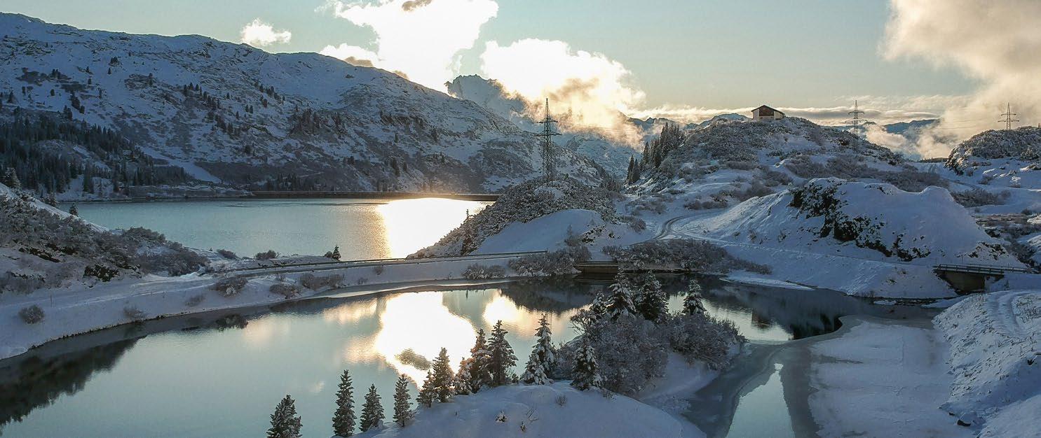
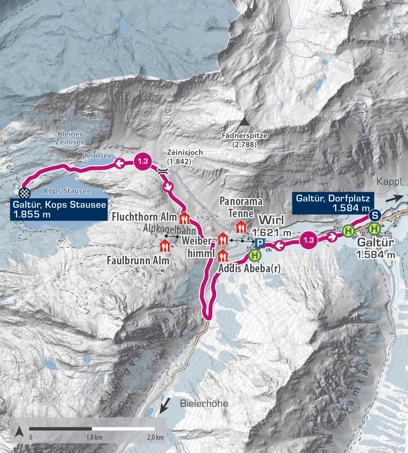
Die dritte Etappe des Winterweitwanderwegs startet in Galtür Dorf und führt über 8,9 Kilometer nach Wirl. Von dort wanderst du weiter Richtung Zeinissee und Kops Stausee. Der Winterwanderweg Zeinis zählt zu den schönsten im Paznaun und bietet faszinierende Einblicke. Er markiert die Grenze zwischen Vorarlberg und Tirol sowie die Europäische Hauptwasserscheide zwischen Rhein und Donau. Entlang des Weges laden mehrere Restaurants zu traditionellen Tiroler Köstlichkeiten ein. Hinweis: Der Alpengasthof Zeinisjoch ist im Winter geschlossen.
The third stage of the winter long-distance trail begins in Galtür village and stretches 8.9 kilometres to Wirl. From there, you continue towards Zeinissee and Kops reservoir. The Zeinis winter trail is one of the most beautiful in Paznaun, offering fascinating insights. It marks the border between Vorarlberg and Tyrol as well as the European watershed between the Rhine and Danube. Several restaurants along the way invite you to enjoy traditional Tyrolean delicacies. Note: The Alpine Inn Zeinisjoch is closed in winter.
Start | start: Galtür, Dorfplatz
Ziel | destination: Galtür, Kops Stausee
Einkehrmöglichkeiten | rest stops: Restaurants auf der Strecke | restaurants at the route
Schwierigkeitsgrad level of difficulty
mittelschwierig | intermediate
Gehzeit walking time 4 h
Distanz distance 18 km
2.000 m
1.800 m
1.600 m
1.400 m
Galtür, Dorfplatz 1.584 m
Galtür, Kops Stausee 1.855 m
Galtür, Dorfplatz 1.584 m E
W.02
SILVRETTA BIELERHÖHE
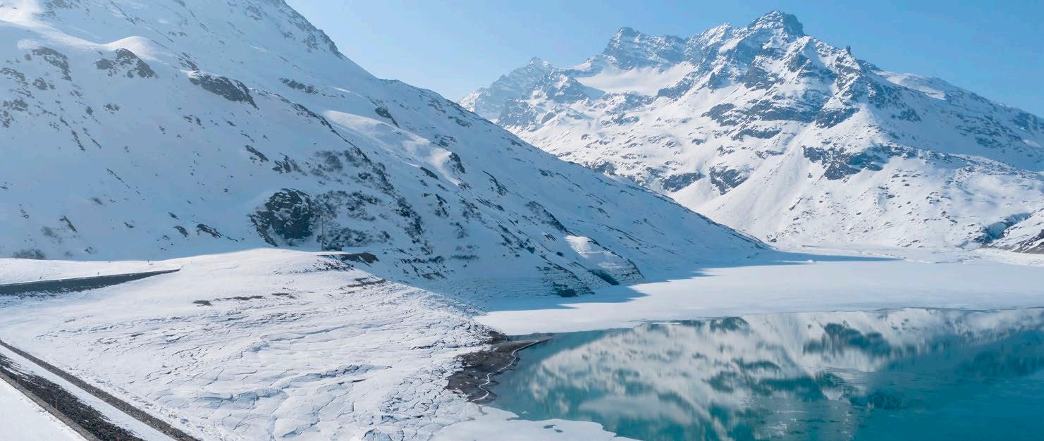
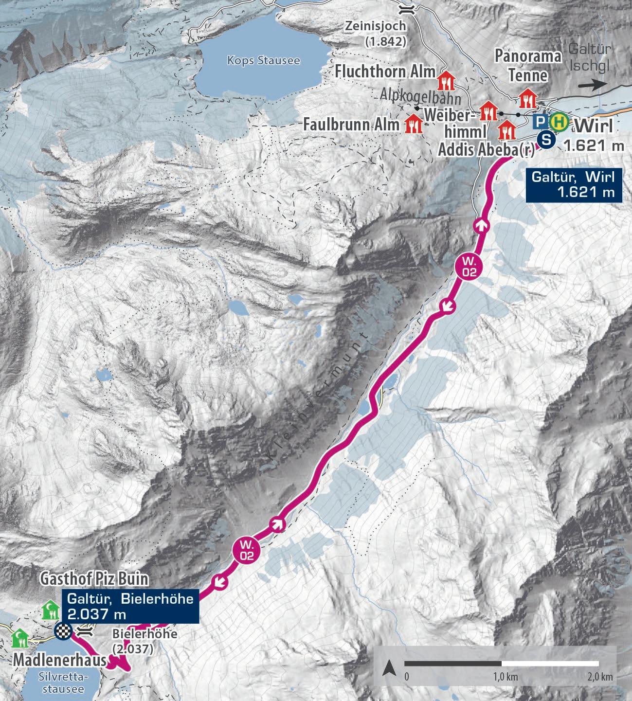
Diese 18 Kilometer lange Winterwanderung ist zwar anspruchsvoll, aber die atemberaubenden Bergpanoramen und tief verschneiten Landschaften lassen dich die Anstrengungen schnell vergessen. Auf der sonnigen Bielerhöhe (2.037 m) mit dem beeindruckenden Silvrettastausee wird das Genießen einfach. Die Tour startet in Wirl, bei der Talstation der Birkhahnbahn. Nach 9 Kilometern erreichst du die Bielerhöhe. Der Rückweg erfolgt auf derselben Strecke, eine Abkürzung mit dem Bus gibt es nicht.
This 18-kilometre winter hike is challenging, but the stunning mountain panoramas and snow-covered landscapes quickly make you forget the effort. On the sunny Bielerhöhe (2,037 m) with the impressive Silvretta reservoir, it‘s easy to relax and enjoy. The tour starts in Wirl, at the Birkhahnbahn valley station. After 9 kilometres, you reach the Bielerhöhe. The return is on the same path, and there is no option to shorten the route by bus.
Start | start: Galtür, Wirl
Ziel | destination: Galtür, Bielerhöhe
Einkehrmöglichkeiten | rest stops: Restaurants auf der Bielerhöhe
Schwierigkeitsgrad level of difficulty
mittelschwierig | intermediate
Gehzeit walking time 5 h Distanz distance 18 km
2.200 m
2.000 m
1.800 m
1.600 m
1.400 m
W.03
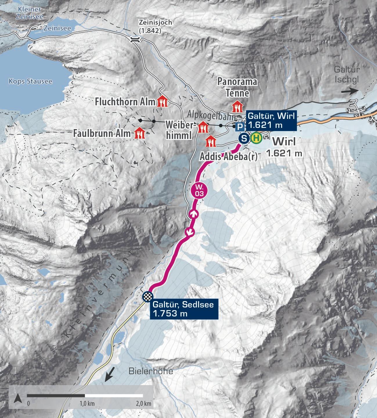
WIRL – SEDLSEE
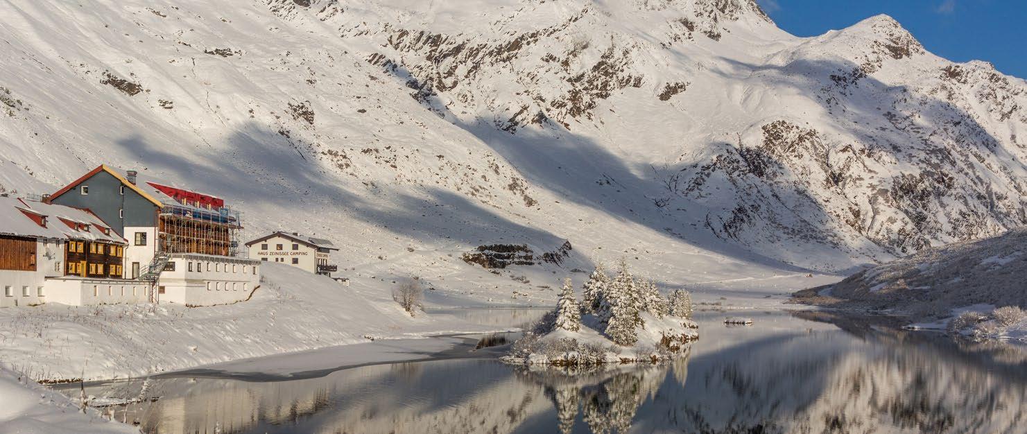
Sanftansteigend führt die Winterwanderung durch die verschneite Landschaft, vorbei an glitzernden Schneefeldern und verschneiten Hängen, bis schließlich der Sedlsee erreicht ist. Unterwegs bieten sich immer wieder traumhafte Ausblicke auf die umliegenden Gipfel, die das Wintererlebnis unvergesslich machen. Der Rückweg nach Wirl erfolgt über dieselbe Route.
Gently scending, the winter hike leads through the snow-covered landscape, past sparkling snowfields and snowy slopes, until it finally reaches the Sedlsee lake. Along the way, there are breathtaking views of the surrounding peaks, making this winter experience truly unforgettable. The return to Wirl follows the same route.
Start | start: Galtür, Wirl
Ziel | destination: Galtür, Sedlsee
Schwierigkeitsgrad level of difficulty
mittelschwierig | intermediate
Gehzeit walking time 2 h Distanz distance 4,9 km
2.000 m
1.800 m
1.600 m
1.400 m
Galtür, Wirl 1.621 m
Galtür, Sedlsee 1.753 m
Galtür, Wirl 1.621 m E
W.04
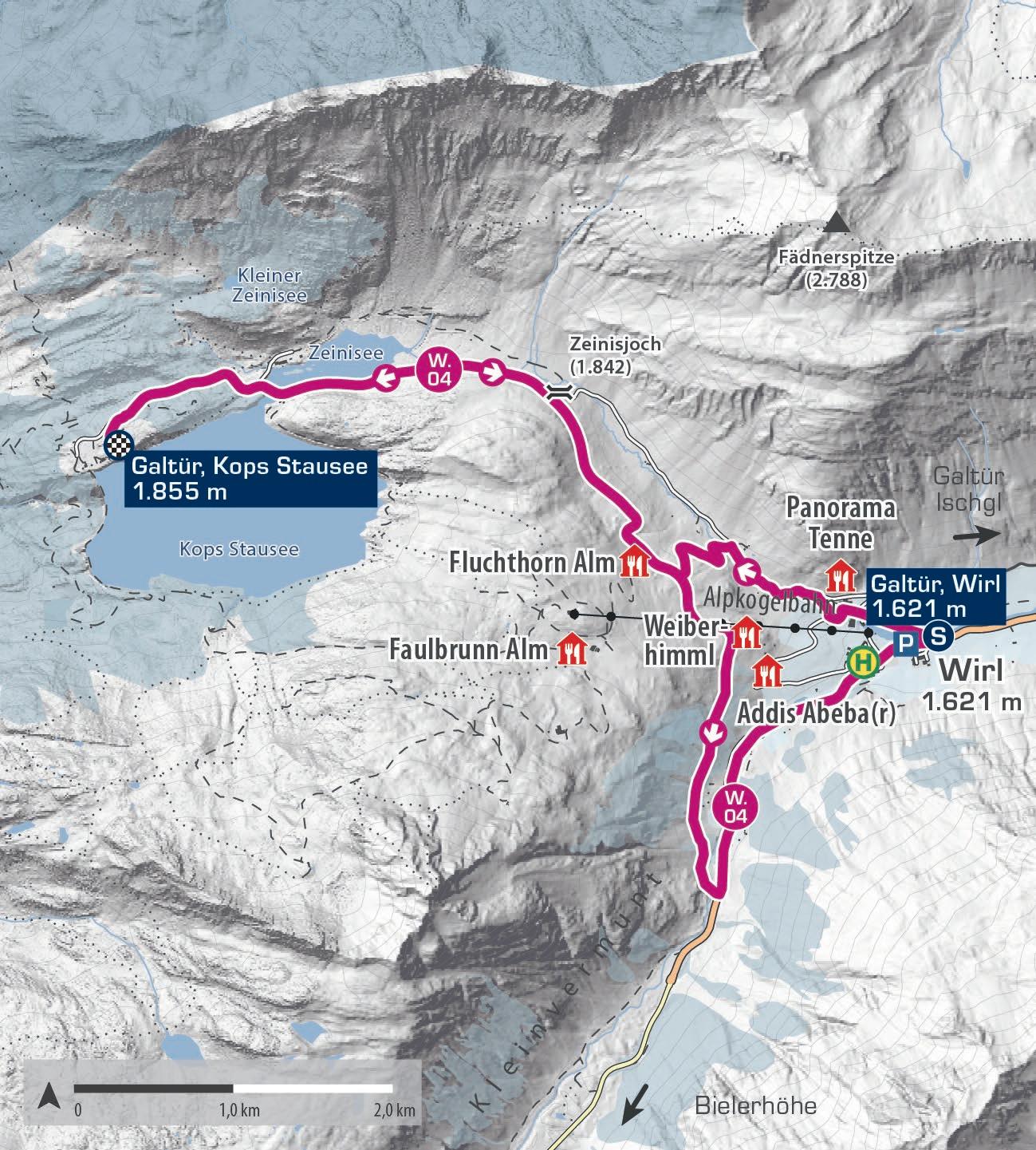
ZEINIS – KOPS
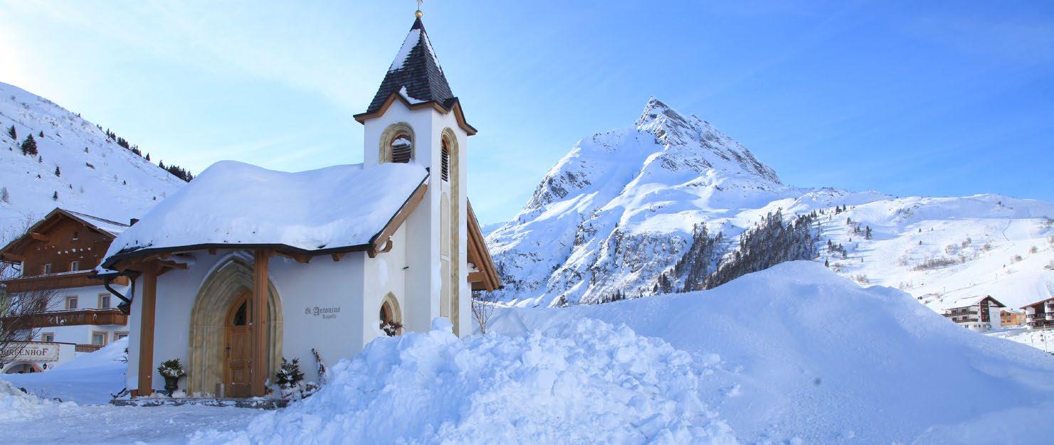
Die Region um den Zeinis- und Kops Stausee gehört zu den malerischsten Plätzen im Paznaun. An der Grenze zu Vorarlberg hast du einen herrlichen Ausblick auf die Silvrettagruppe. Deine Wanderung beginnt in Wirl, nahe der St. Antonius Kapelle, und führt stetig bergauf über die alte Zeinisstraße. Nach 7 Kilometern erreichst du die beiden Stauseen. Es gibt Einkehrmöglichkeiten im Skigebiet und in Wirl. Eine Busverbindung zur Abkürzung besteht nicht.
The area around the Zeinissee lake and Kops reservoirs is one of the most picturesque spots in Paznaun. Located on the border with Vorarlberg, you’ll enjoy stunning views of the Silvretta group. Your hike starts in Wirl, near the St. Antonius Chapel, and steadily climbs along the old Zeinis road. After 7 kilometres, you’ll reach both reservoirs. There are places to stop for refreshments in the ski area and in Wirl. There is no bus connection for a shortcut.
Start | start: Galtür, Wirl
Ziel | destination: Galtür, Kops Stausee
Einkehrmöglichkeiten | rest stops: Restaurants in Galtür/Wirl und im Skigebiet
Restaurants in Galtür/Wirl and in the ski area
Schwierigkeitsgrad level of difficulty
mittelschwierig | intermediate Gehzeit walking time 4 h Distanz distance 14 km
2.000 m
1.800 m
1.600 m
1.400 m
Galtür,Kops Stausee 1.855 m
W.05
KLEINZEINIS
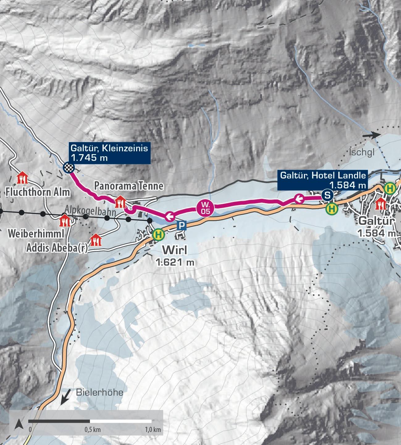
Der Winterwanderweg Kleinzeinis ist ideal für einen entspannten Spaziergang in verschneiter Berglandschaft. Er verläuft größtenteils flach entlang der Trisanna, der Einstieg befindet sich direkt vor dem Hotel Landle in Galtür. Der gut präparierte Weg erfordert keine besondere Kondition und eignet sich perfekt für einen gemütlichen Winterspaziergang.
The Kleinzeinis winter hiking trail is ideal for a relaxing stroll through snow-covered mountain scenery. It runs mostly flat along the Trisanna river, with the starting point located directly in front of the Hotel Landle in Galtür. The well prepared path requires no particular level of fitness and is perfect for a leisurely winter walk.
Start | start: Galtür, Hotel Landle
Ziel | destination: Galtür, Kleinzeinis
Einkehrmöglichkeiten | rest stops: Restaurants in Galtür/Wirl und im Skigebiet
Restaurants in Galtür/Wirl and in the ski area
Schwierigkeitsgrad level of difficulty
leicht | easy
Gehzeit walking time 1,5h
Distanz distance 4,6 km
2.000 m
1.800 m
1.600 m
1.400 m
Galtür, Hotel Landle 1.584 m
Galtür, Kleinzeinis 1.745 m
Galtür, Hotel Landle 1.584 m E
W.06
SILVAPARK
Nach einer kurzen Fahrt mit der Alpkogelbahn erreichst du den Startpunkt des Winterwanderweges Silvapark. Entspanne dich in einem Liegestuhl und genieße die atemberaubende Aussicht. Folge dem markierten Weg ins Tal, vorbei an der Faulbrunn Alm und der Fluchthorn Alm, wo du auf den sonnigen Terrassen Tiroler Köstlichkeiten genießen kannst. Nach der Wanderung durch den Silvapark erreichst du Oberwirl. Von dort kannst du weiter Richtung Galtür wandern. Achtung: Der Weg kreuzt Pisten, Skifahrer und Snowboarder sind unterwegs.
After the ascent with the Alpkogelbahn, you’ll reach the starting point of the Silvapark winter hiking trail. Relax in a deckchair and take in the breathtaking views. Follow the marked path towards the valley, passing the Faulbrunn Alm and the Fluchthorn Alm lodges, where you can enjoy Tyrolean delicacies on their sunny terraces. After hiking through the Silvapark, you‘ll reach Oberwirl. From there, you can continue towards Galtür. Note: The trail crosses ski slopes, so be cautious of skiers and snowboarders.
Start | start: Galtür, Bergstation Alpkogelbahn
Ziel | destination: Galtür, Wirl
Einkehrmöglichkeiten | rest stops: Restaurants im Silvapark
Schwierigkeitsgrad level of difficulty
leicht | easy
Gehzeit walking time 1,5-2 h
Distanz distance 3 km
2.200 m
2.000 m
1.800 m
1.600 m
1.400 m

W.07
ALPKOGEL
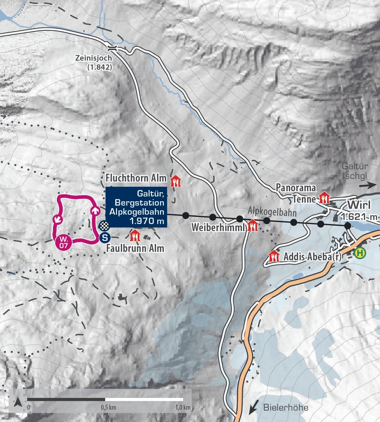
Nach einer kurzen Fahrt mit der Alpkogelbahn und einem fünfminütigen Fußmarsch erreichst du den Startpunkt der Winterrundwanderung Alpkogel. Auf rund einem Kilometer führt der Weg als Rundweg mitten durch den Silvapark und eröffnet Ausblicke auf die verschneite Silvrettagruppe sowie auf die Pisten und Liftanlagen, die sich am Hang der Ballunspitze hinauf und hinunter ziehen.
Achtung: Der Weg kreuzt Pisten, Skifahrer und Snowboarder sind unterwegs.
After a short ride with the Alpkogelbahn and a five-minute walk, you reach the starting point of the Alpkogel winter circular trail. Covering about one kilometre, the route loops through the heart of the Silvapark and offers views of the snow-covered Silvretta range as well as the pistes and lifts that run up and down the slopes of the Ballunspitze. Note: The trail crosses ski slopes, so be cautious of skiers and snowboarders.
Start | start: Galtür, Bergstation Alpkogelbahn
Ziel | destination: Galtür, Bergstation Alpkogelbahn
Einkehrmöglichkeiten | rest stops: Restaurants im Silvapark
Schwierigkeitsgrad
level of difficulty
leicht | easy
Gehzeit walking time 0,5 h
Distanz distance 1,1 km
2.200 m
2.100 m
2.000 m
1.900 m
1.800 m
Galtür, Bergstation Alpkogelbahn 1.970 m
Galtür, Bergstation Alpkogelbahn 1.970 m
W.08
MENTA ALM
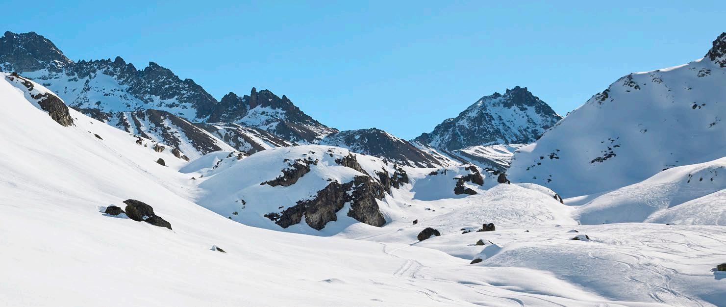
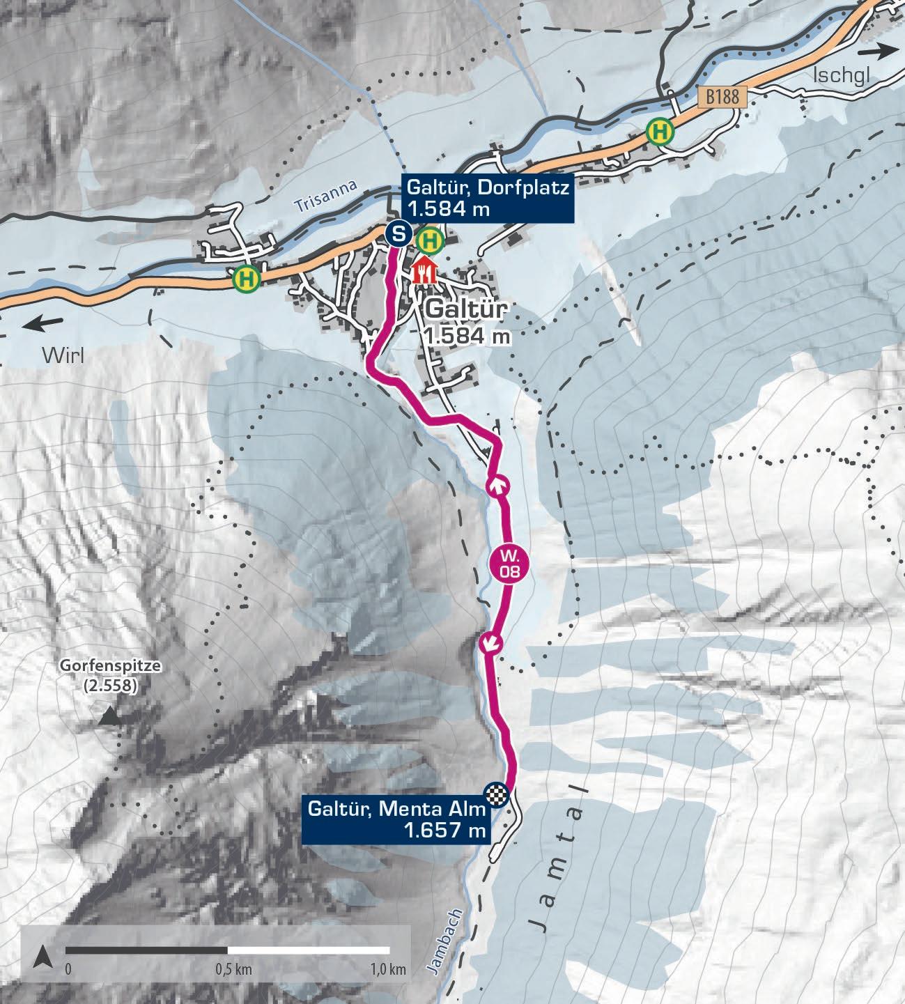
Der Winterwanderweg Menta Alm startet in Galtür Dorf. Er führt südwärts ins Jamtal, wo du bereits zu Beginn einen atemberaubenden Blick auf den Jamtalgletscher hast. Das Jamtal ist eines der schönsten Seitentäler des Paznaun, umgeben von zahlreichen 3.000ern wie der Vorderen und Hinteren Jamspitze. Nach etwa 2 Kilometern endet der Weg, und du kehrst auf derselben Strecke zurück. Hinweis: Die Menta Alm bleibt im Winter geschlossen.
The Menta Alm winter hiking trail starts in the village of Galtür. It heads south into the Jamtal valley, where you‘ll immediately enjoy stunning views of the Jamtal Glacier. The Jamtal valley is one of Paznaun‘s most beautiful side valleys, surrounded by numerous peaks over 3,000 metres, including the Vordere Jamspitze and the Hintere Jamspitze. After about 2 kilometres, the trail ends, and you return along the same path. Note: The Menta Alm lodge is closed in winter.
Start | start: Galtür, Dorfplatz
Ziel | destination: Galtür, Menta Alm
Einkehrmöglichkeiten | rest stops: Restaurants in Galtür
Schwierigkeitsgrad
level of difficulty
leicht | easy
Gehzeit walking time 2 h
Distanz distance 4 km
2.000 m
1.800 m
1.600 m
1.400 m
Galtür, Dorfplatz 1.584 m
Galtür, Menta Alm 1.657 m
Galtür, Dorfplatz 1.584 m E
W.09
GALTÜR – WIRL
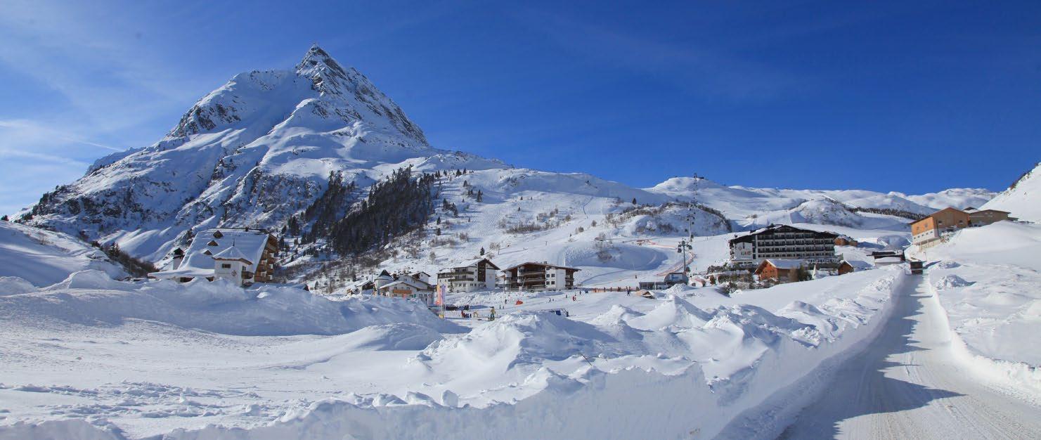
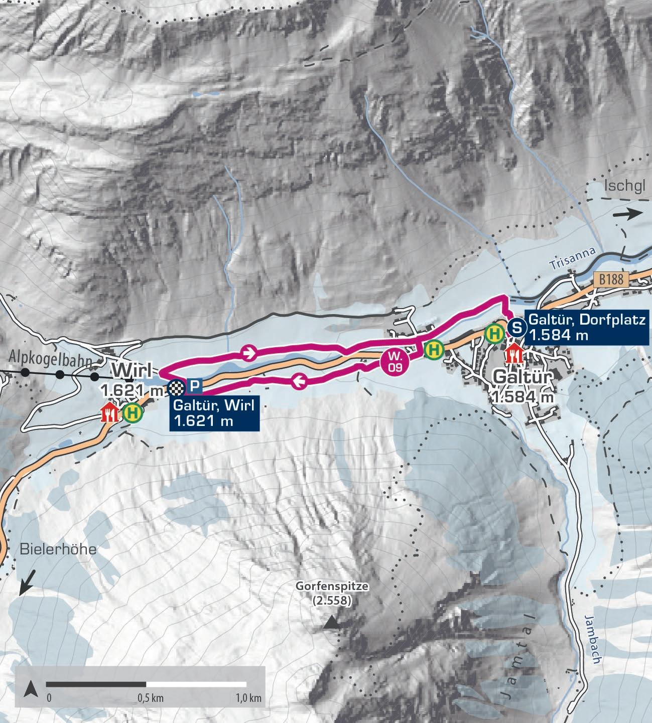
Der Winterwanderweg zwischen Galtür und Wirl ist vier Kilometer lang und hat nur leichte Steigungen, was moderate Kondition erfordert. Der Startpunkt ist der Dorfplatz Galtür. Der Weg verläuft flach entlang des Vermuntbaches bis zur Talstation der Birkhahnbahn in Wirl. Genieße die verschneite Landschaft in Galtür, dem höchstgelegenen Ort des Paznauns, umgeben von den imposanten Gipfeln der Silvretta. Besonders empfehlenswert ist die Tour am Mittwochabend, wenn der Silvapark im Lichterglanz erstrahlt.
The winter hiking trail between Galtür and Wirl is four kilometres long with gentle inclines, requiring moderate fitness. Starting at Galtür village square the path follows the Vermuntbach stream flatly until reaching the Birkhahnbahn valley station in Wirl. Enjoy the snowy landscape in Galtür, the highest village in Paznaun, surrounded by the towering peaks of the Silvretta range. This hike is especially recommended on Wednesday evenings when the Silvapark is illuminated by the lights of night skiing.
Start | start: Galtür, Dorfplatz
Ziel | destination: Galtür, Wirl
Einkehrmöglichkeiten | rest stops: Restaurants in Galtür/Wirl
Schwierigkeitsgrad
level of difficulty
mittelschwierig | intermediate
Gehzeit walking time 1,5 h
Distanz distance 4 km
1.800 m
1.700 m
1.600 m
1.500 m
1.400 m
Galtür, Dorfplatz 1.584 m
Galtür, Dorfplatz 1.584 m E Galtür, Wirl 1.621 m
W.10
WALDKAPELLE
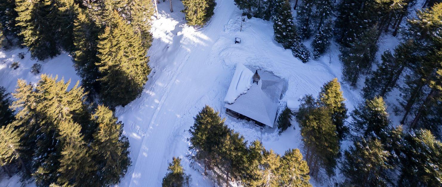
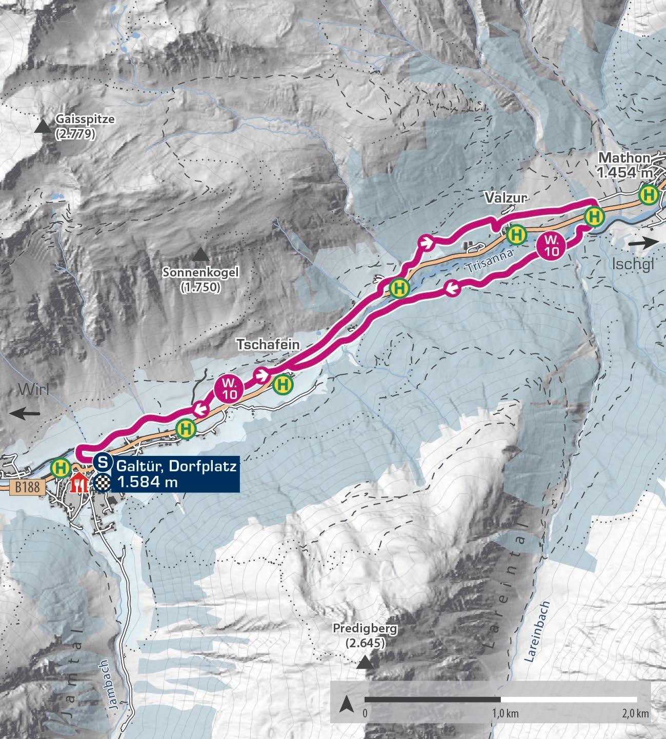
Die Winterrundwanderung beginnt am Dorfplatz in Galtür und führt dich flach entlang der Trisanna bis zum Weiler Tschafein. Weiter geht es am Gehsteig zum Haus „Rifugio“ und ein kurzes Stück entlang der Bundesstraße, bevor der gewalzte Winterwanderweg links abzweigt. Du wanderst durch das Waldgebiet oberhalb der Straße, gelangst zum Wildpark am Valzurbach, und nach einer kurzen Steigung erreichst du die romantische Waldkapelle. Die neun Kilometer lange Wanderung erfordert etwas Kondition, bietet aber beeindruckende Ausblicke auf die Ballunspitze.
The winter circular trail starts at the Galtür village square, leading you flat along the Trisanna river to the hamlet of Tschafein. From there, continue on the pavement to the “Rifugio” house and briefly along the main road before returning to the groomed winter hiking trail on the left. You hike through the forest above the road, reach the wildlife park by the Valzurbach stream, and after a short incline, you arrive at the romantic forest chapel. The nine-kilometre hike requires some fitness but offers stunning views of the Ballunspitze.
Start | start: Galtür, Dorfplatz
Ziel | destination: Galtür, Dorfplatz
Einkehrmöglichkeiten | rest stops: Restaurants in Galtür
Schwierigkeitsgrad
level of difficulty
mittelschwierig | intermediate
Gehzeit walking time 2,5 h
Distanz distance 9 km
1.900 m
1.700 m
1.500 m
1.300 m
Dorfplatz 1.584 m
W.11
PANORAMATOUR VERWALL
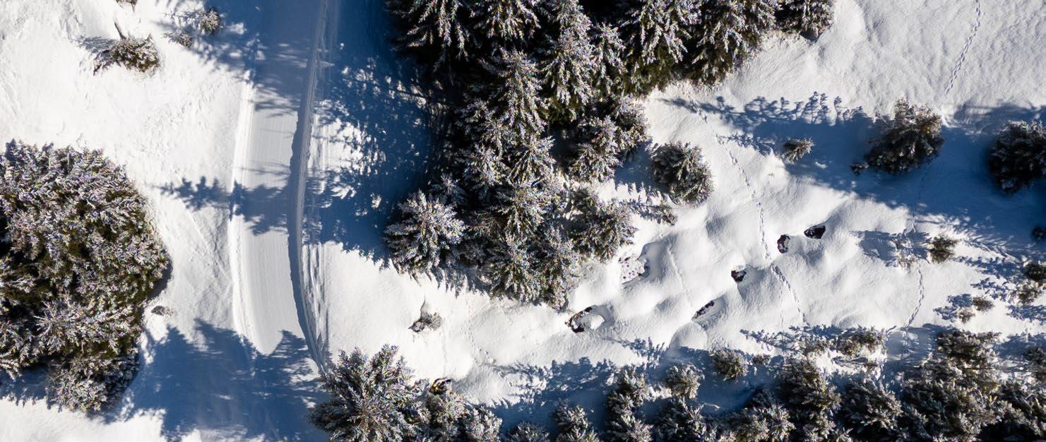
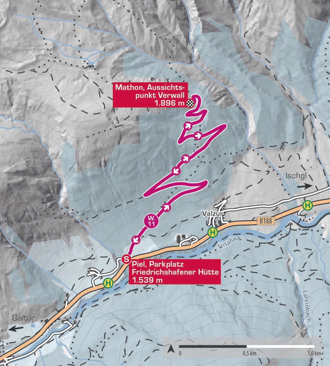
Der Ausgangspunkt Parkplatz Friedrichshafener Hütte liegt im Ortsteil Piel zwischen Ischgl und Galtür und ist mit dem Auto oder Bus erreichbar (Bushaltestelle Piel, dann ein kurzes Stück talauswärts). Der Weg führt in vielen Serpentinen, aber nie zu steil, 500 Höhenmeter hinauf zu einem großartigen Aussichtspunkt unterhalb der Friedrichshafener Hütte (im Winter geschlossen), mit Blick auf die beeindruckende Bergwelt der Silvretta- und Samnaungruppe. Der Rückweg erfolgt auf derselben Strecke.
The starting point, Friedrichshafener Hütte car park, is located in Piel between Ischgl and Galtür and is accessible by car or bus (Piel bus stop, then a short walk downstream). The trail winds up in many switchbacks, but never too steeply, gaining 500 metres in elevation to a fantastic viewpoint below the Friedrichshafener Hütte lodge (closed in winter) with views of the impressive Silvretta and Samnaun mountain ranges. The return follows the same path.
Start | start: Piel, Parkplatz Friedrichshafener Hütte
Ziel | destination: Mathon, Aussichtspunkt Verwall
Einkehrmöglichkeiten | rest stops: keine | none
Schwierigkeitsgrad
level of difficulty
mittelschwierig | intermediate
Gehzeit walking time 3,5 h
Distanz distance 7 km
2.000 m
1.800 m
1.600 m
1.400 m
Piel, Parkplatz Friedrichshafener Hütte 1.539 m
Mathon, Aussichts- punkt Verwall 1.896 m
Piel, Parkplatz Friedrichshafener Hütte 1.539 m E
W.12
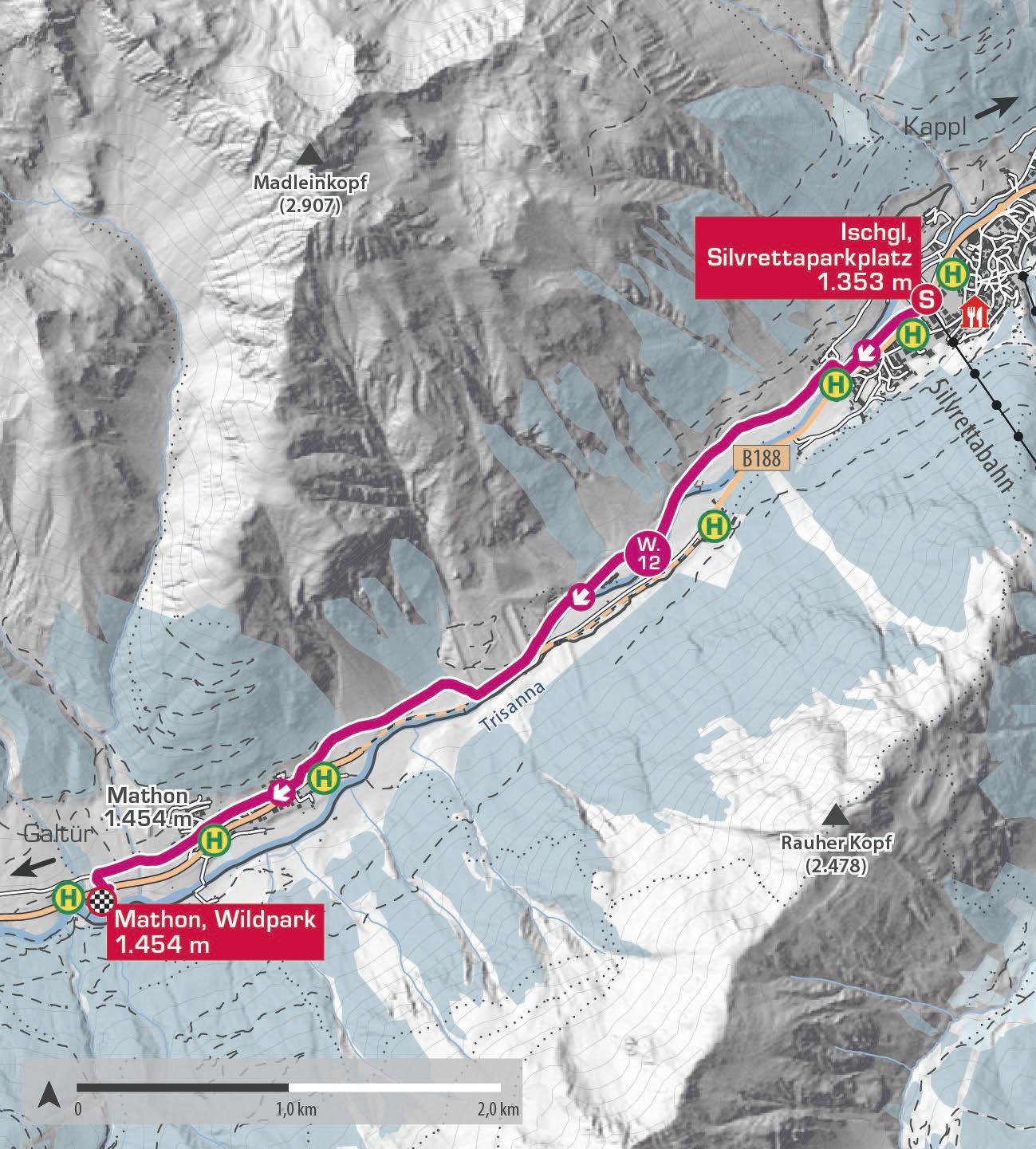
ISCHGL – MATHON
Der Winterwanderweg von Ischgl nach Mathon ist ideal für eine entspannte Erkundung. Leicht begehbar und dennoch aktivierend, startet der Weg am Silvrettaparkplatz. Gut ausgeschildert führt er zunächst neben der Loipe, bevor er im Weiler Paznaun auf einen eigenen Pfad abzweigt. Meist flach verläuft der Weg Richtung Mathon. Nach Mathon überquerst du den Valzurbach und erreichst den Wildpark. Alternativ kannst du auf der anderen Seite der Trisanna nach Ischgl zurückwandern. Der Weg ist auch umgekehrt begehbar.
The winter hiking trail from Ischgl to Mathon is perfect for a relaxed exploration. Easy to walk yet engaging, the route starts at the Silvretta car park. Well-signposted, it first follows the cross-country ski track before branching off onto its own path in the hamlet of Paznaun. Mostly flat, the trail leads towards Mathon. After Mathon, you cross the Valzurbach stream and reach the wildlife park. Alternatively, you can return to Ischgl on the other side of the Trisanna river. The trail is also walkable in reverse.
Start | start: Ischgl, Silvrettaparkplatz
Ziel | destination: Mathon, Wildpark
Einkehrmöglichkeiten | rest stops: Restaurants in Ischgl/Mathon
Schwierigkeitsgrad
level of difficulty
leicht | easy
Gehzeit walking time 2 h
Distanz distance 5 km
1.600 m
1.500 m
1.400 m
1.300 m
1.200 m
W.13
MUTTA
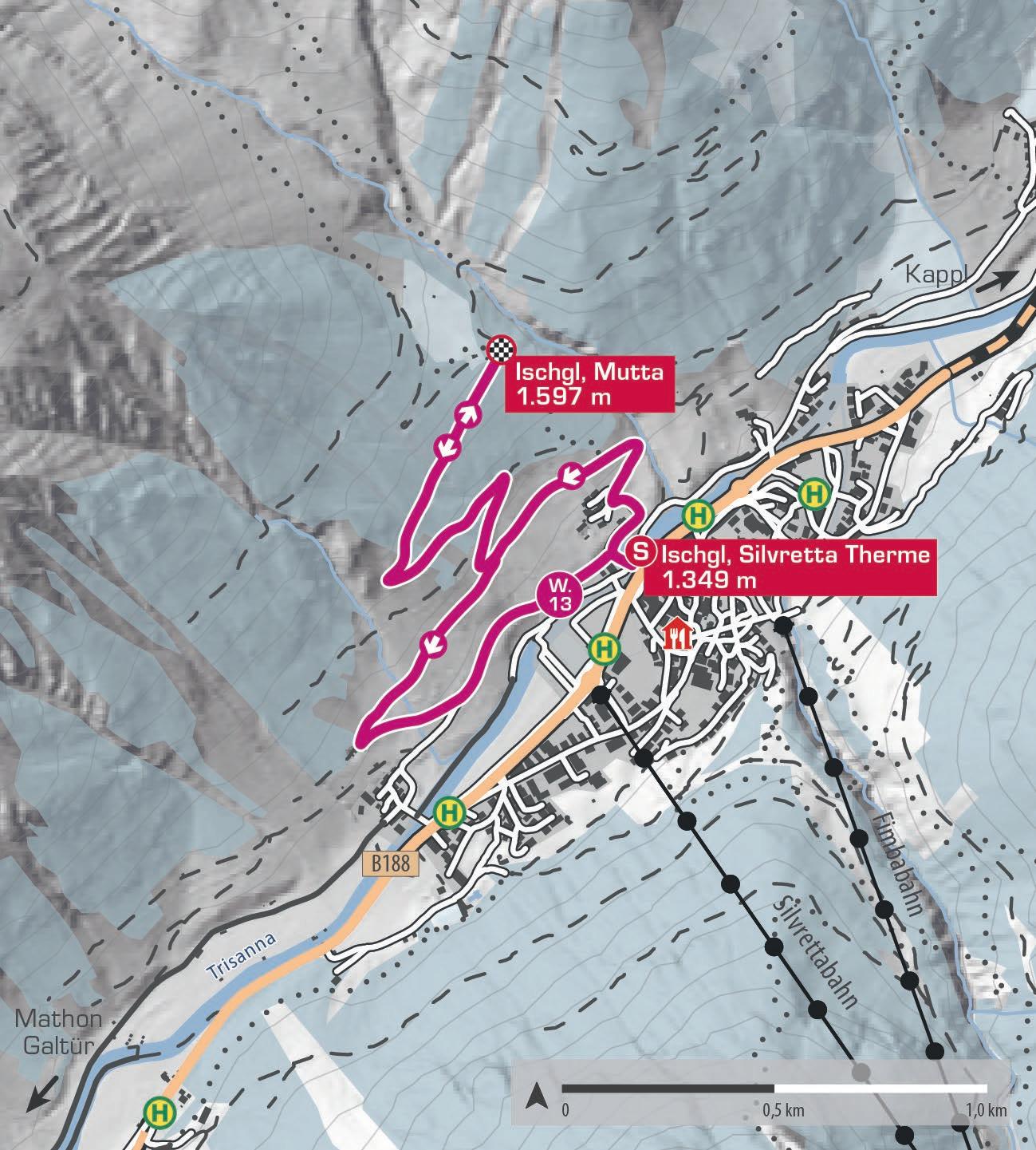
Der Winterwanderweg auf die Mutta führt vom Zentrum Ischgls in Serpentinen durch tief verschneite Wälder hinauf. Von der Silvretta Therme folgst du der Beschilderung bergauf Richtung Mutta. Der breite Weg schlängelt sich 2,5 Kilometer bergauf und bietet grandiose Ausblicke. Oben angekommen genießt du einen wunderbaren Blick auf Ischgl und das Geschehen aus der Ferne. Auf dem Rückweg kannst du die Route verlängern und über den Weiler Paznaun spazieren, wo Sonnenbänke zum Verweilen einladen. Danach geht es zurück ins Dorf.
The winter hiking trail to the Mutta winds up from the centre of Ischgl through snowcovered forests in switchbacks. From the Silvretta Therme, follow the signs uphill towards Mutta. The wide path climbs 2.5 kilometres, offering magnificent views. At the top, you can enjoy a wonderful view of Ischgl and the activity below from a distance. On the way back, you can extend the route by walking through the hamlet of Paznaun, where sun benches invite you to relax. Then, return to the village.
Start | start: Ischgl, Silvretta Therme
Ziel | destination: Ischgl, Mutta
Einkehrmöglichkeiten | rest stops: Restaurants in Ischgl
Schwierigkeitsgrad
level of difficulty
leicht | easy
Gehzeit walking time 2 h
Distanz distance 5 km
1.800 m
1.600 m
1.400 m
1.200 m
W.14
ISCHGL – EBENE
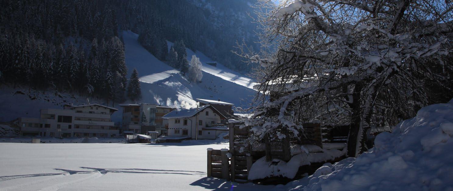
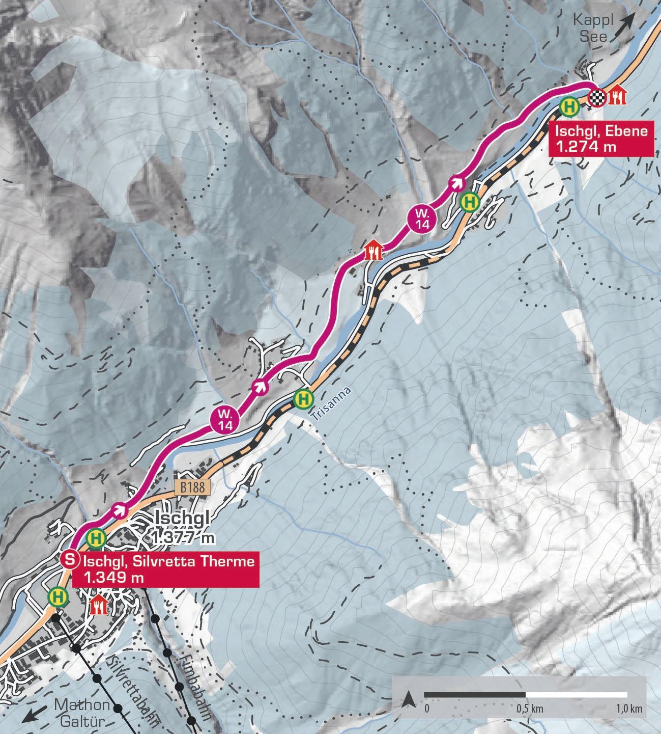
Dieser gemütliche Winterwanderweg führt von Ischgl auf dem Talweg Richtung Kappl. Nach der Silvretta Therme folgst du der Beschilderung „Winterwanderweg Ebene“ talauswärts. Kurz darauf überquerst du den rauschenden Madleinbach und passierst die Ortsteile Versahl, Vergröß, Platt und schließlich Ebene. Oberhalb der Trisanna kannst du die Ruhe und die verschneite Landschaft genießen. In Ebene gibt es eine Bushaltestelle, von der aus du bequem nach Ischgl zurückfahren kannst. Wer noch Energie hat, wandert auf demselben Weg zurück.
This leisurely winter hiking trail leads from Ischgl along the valley path towards Kappl. After the Silvretta Therme, follow the signs for „Winterwanderweg Ebene“ downstream. Shortly after, you cross the rushing Madleinbach stream and pass through the hamlets of Versahl, Vergröß, Platt, and finally Ebene. Above the Trisanna river, you can enjoy the peace and the snow-covered landscape. In Ebene, there is a bus stop from where you can easily return to Ischgl. If you still have energy, you can walk back along the same path.
Start | start: Ischgl, Silvretta Therme
Ziel | destination: Ischgl, Ebene
Einkehrmöglichkeiten | rest stops: Restaurants in Ischgl/Ebene
Schwierigkeitsgrad
level of difficulty
leicht | easy
Gehzeit walking time 2 h
Distanz distance 4 km
1.600 m
1.500 m
1.400 m
1.300 m
1.200 m
W.15
SCHMUGGLERTOUR INS ZOLLFREIE SAMNAUN
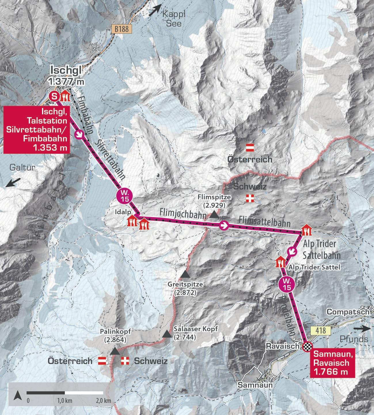
Die Schmugglertour ins zollfreie Samnaun bietet eine einmalige Kombination aus Wandererlebnis und exklusivem Einkaufsvergnügen. Vom Ischgler Dorfzentrum geht es mit der Fimba- oder Silvrettabahn hinauf zur Idalp auf 2.300 Metern. Weiter geht es mit der Flimjochbahn zum Viderjoch auf 2.700 Metern, der Grenze zwischen Österreich und der Schweiz. Danach bringt dich die Flimsattelbahn zur Alp Trida. Von dort erreichst du zu Fuß die Alp Trider Sattelbahn. Mit der Pendelbahn (L1/L2) geht es nach Samnaun zum Einkaufen. Rückweg spätestens um 14:30 Uhr antreten, um nach Ischgl zurückzukehren. Hinweis: Die Beförderung von Hunden mit Sesselbahnen ist untersagt, freilaufende Hunde auf Pisten sind verboten.
The Smugglers‘ Tour to duty-free Samnaun offers a unique hiking experience combined with shopping. From Ischgl village centre, take either the Fimbabahn or Silvrettabahn up to Idalp at 2,300 metres. Then, ride the Flimjochbahn to Viderjoch at 2,700 metres, the border between Austria and Switzerland. Next, take the Flimsattelbahn to Alp Trida. After a short walk, reach the Alp Trider Sattelbahn. The double-decker cable car (L1/L2) then takes you down to Samnaun for shopping. Start your return by 2:30 pm to ensure a lift back to Ischgl. Note: Dogs cannot be transported on chair lifts, free running dogs on slopes are not allowed.
Start | start: Ischgl, Talstation Silvrettabahn/Fimbabahn
Ziel | destination: Samnaun, Ravaisch
Einkehrmöglichkeiten | rest stops: Restaurants in der Silvretta Arena
Schwierigkeitsgrad level of difficulty
leicht | easy
Gehzeit
walking time
Fahrt | trip: 1,5 – 2 h
Distanz distance 24 km
1.200 m 1.500 m 1.800 m 2.100 m 2.400 m 2.700 m 3.000 m
Ischgl, Talstation Silvrettabahn/ Fimbabahn 1.353 m
Samnaun, Ravaisch 1.766 m
Ischgl, Talstation Silvrettabahn/ Fimbabahn 1.353 m E
SENDA ALP TRIDA – ALP BELLA
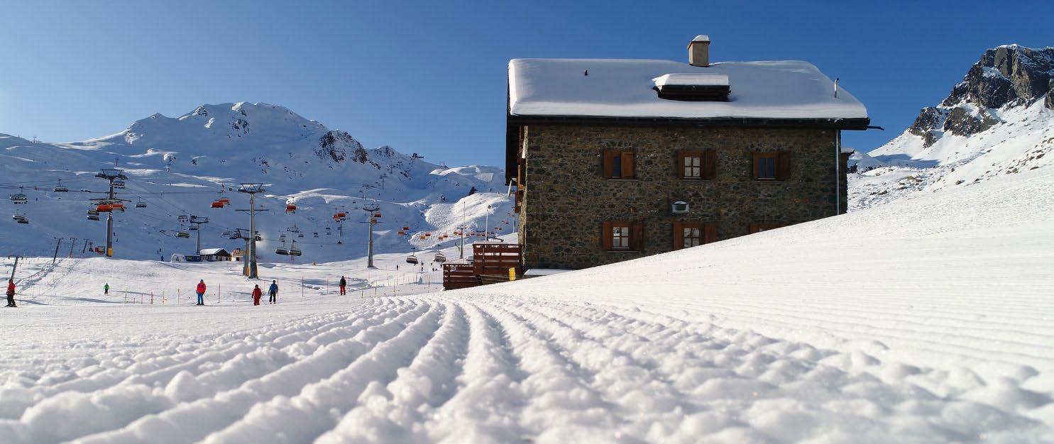
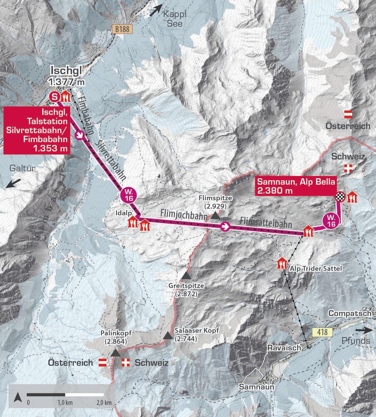
Der Ausgangspunkt dieser Winterwanderung ist die Talstation der Silvrettabahn. Von dort geht es hinauf zur Idalp und weiter mit der Flimjochbahn auf das Äußere Viderjoch. Anschließend fährt man weiter mit der Flimsattelbahn in die Schweiz. Der Winterwanderweg startet beim Skihaus Alp Trida. Von dort führt der Weg zunächst 200 Meter entlang der Piste 68b bergauf und steigt danach leicht an bis zur Alp Bella auf 2.380 Metern. Hier eröffnet sich ein beeindruckendes Panorama mit Blick auf den Piz Mundin, den Muttler und die Ötztaler Alpen.
The starting point of this winter hike is the Silvrettabahn valley station. From there, the route leads up to the Idalp and continues with the Flimjochbahn to the Outer Viderjoch. The journey then carries on with the Flimsattelbahn into Switzerland. The winter hiking trail begins at the Alp Trida mountain restaurant. From here, the trail first follows piste 68b uphill for 200 metres before continuing with a gentle ascent to the Alp Bella lodge at 2,380 metres. An impressive panorama opens up here, with views of Piz Mundin, Muttler and the Ötztal Alps.
Start | start: Ischgl, Talstation Silvrettabahn
Ziel | destination: Samnaun, Alp Bella
Einkehrmöglichkeiten | rest stops: Restaurants Alp Trida, Alp Bella W.16
Schwierigkeitsgrad level of difficulty
mittelschwierig | intermediate
Gehzeit walking time 2 h
Distanz distance 3,4 km
2.400 m 2.800 m
2.000 m
1.600 m
1.200 m
W.17
SAMNAUN ALP TRIDER SATTEL – SALAAS
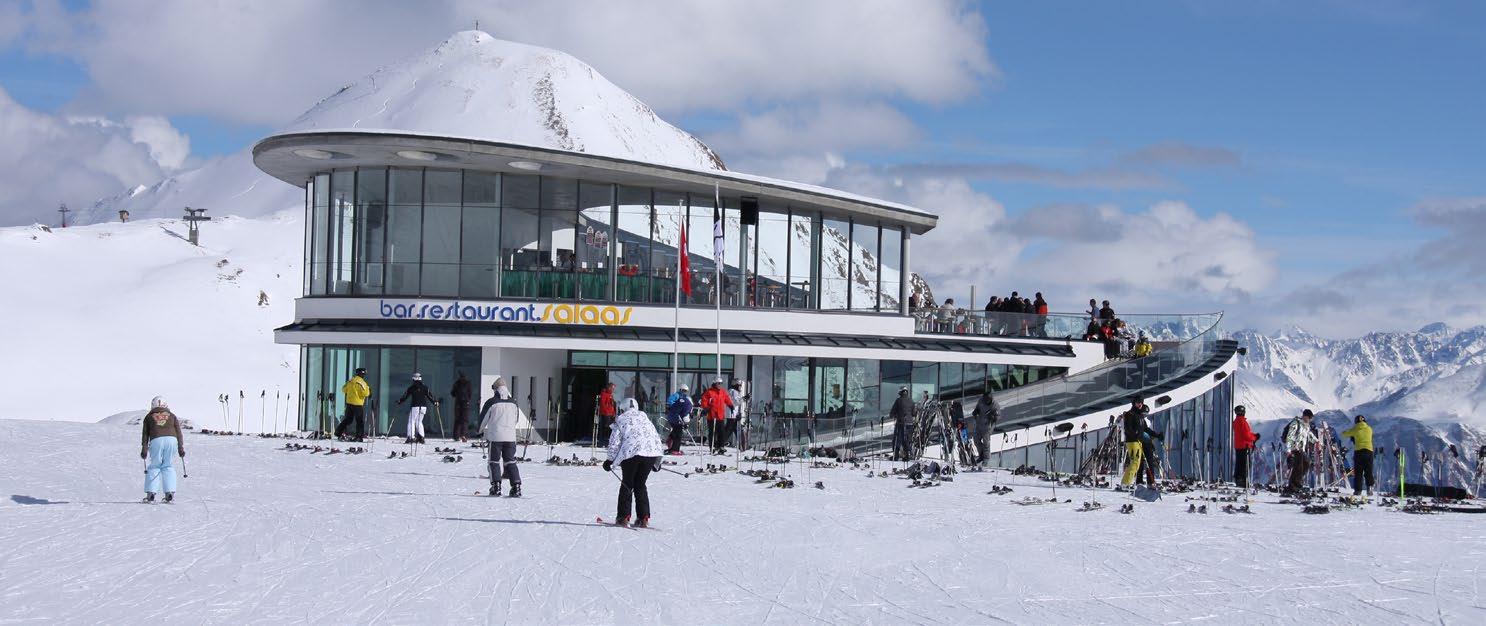
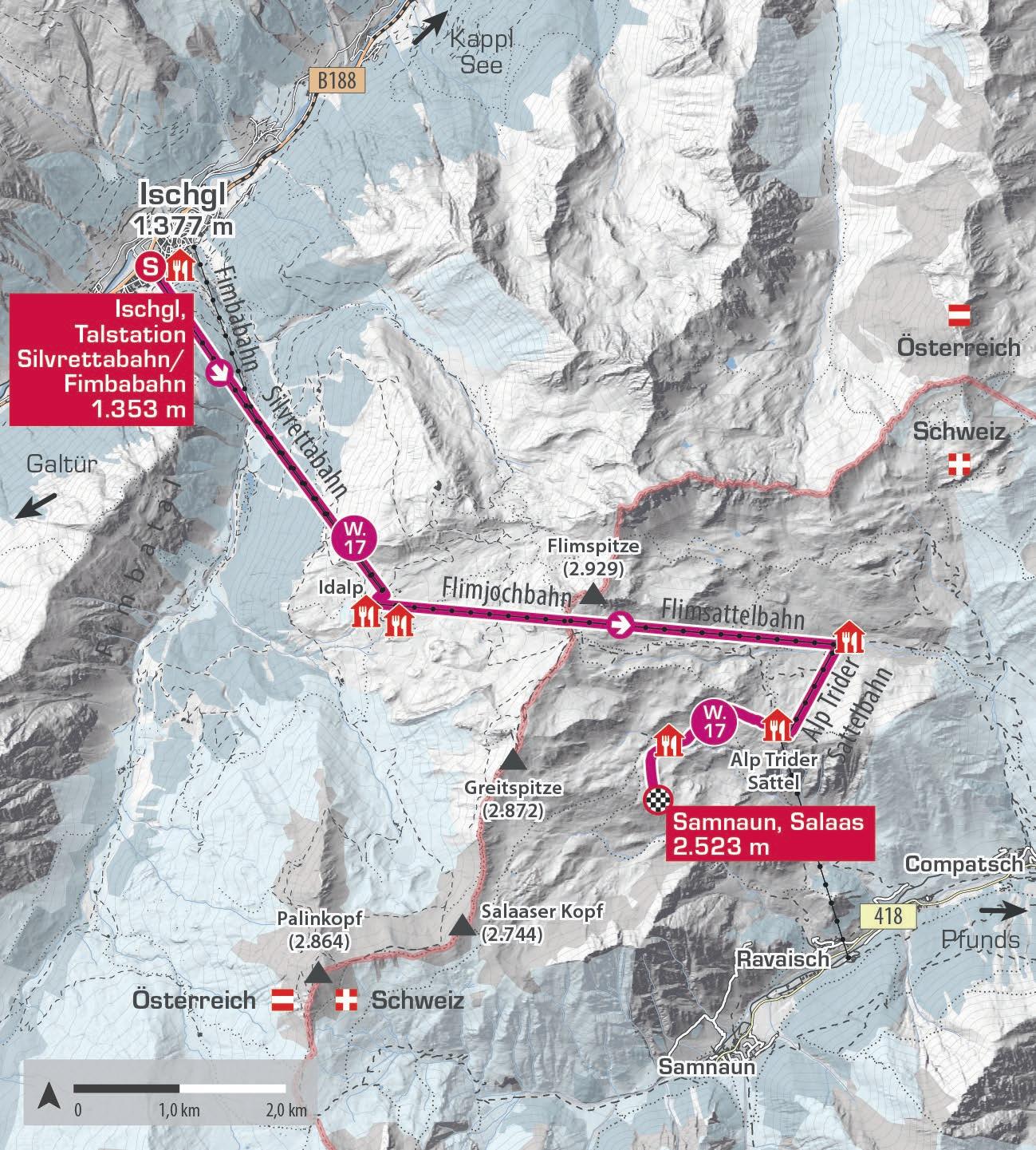
Von der Talstation der Silvrettabahn geht es mit der Gondel zur Idalp. Anschließend führt die Flimjochbahn auf das Äußere Viderjoch, von wo die Flimsattelbahn hinunter in die Schweiz fährt. Hier beginnt der Winterwanderweg beim Skihaus Alp Trida. Ab dem Alp Trider Sattel verläuft die Route mit leichten Steigungen über das Alp Trider Eck bis nach Salaas, begleitet von eindrucksvollen Ausblicken auf die Samnauner Bergwelt. Der Rückweg erfolgt auf derselben Strecke. Einkehrmöglichkeiten bieten das Restaurant Salaas sowie die Sonnenterrasse des Panorama Restaurants Sattel.
Starting from the Silvrettabahn valley station, the cable car takes you up to the Idalp. From there, the Flimjochbahn continues to the Outer Viderjoch, before the Flimsattelbahn descends into Switzerland. Here, the winter hiking trail begins at the Alp Trida mountain restaurant. From the Alp Trider Sattel, the route leads with gentle ascents via the Alp Trida ridge to Salaas, accompanied by impressive views of the Samnaun mountains. The return follows the same route. Refreshment stops include the Salaas Restaurant and the sun terrace of the Panorama Restaurant Sattel.
Start | start: Ischgl, Talstation Silvrettabahn
Ziel | destination: Samnaun, Salaas
Einkehrmöglichkeiten | rest stops: Panorama Restaurant Sattel
Schwierigkeitsgrad
level of difficulty
leicht | easy
2.800 m
2.400 m
2.000 m
1.600 m
1.200 m
W.18
KAPPL – SEE
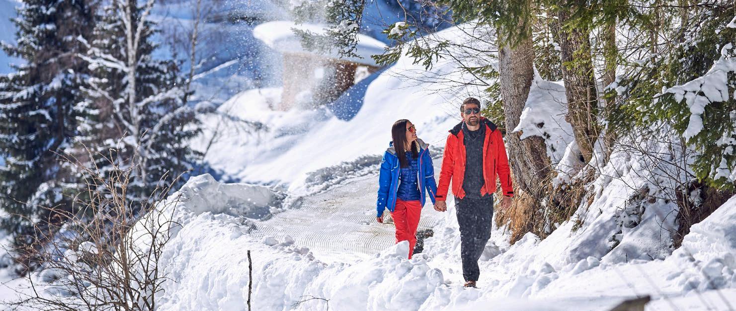
Diese abwechslungsreiche Strecke führt dich durch mehrere ursprüngliche Weiler entlang des Weges. Der Startpunkt ist die Kirche in Kappl, und der Weg verläuft zunächst entlang der Gemeindestraße durch die Weiler Schmiedsegg, Niederhof, Untermühl und Platti. Weiter talauswärts wechselt die Route ab der Abzweigung Holdernach zwischen Waldwegen und asphaltierten Abschnitten. Du passierst die Ortsteile Holdernach, Sesselebene und Schnatzerau, bis du schließlich die Talstation der Medrigjochbahn erreichst. Die Tour ist auch in umgekehrter Richtung möglich, und bei Bedarf kannst du bequem mit dem Bus zum Ausgangspunkt zurückkehren.
This varied route takes you through several traditional hamlets along the way. Starting at Kappl Church, the path initially follows the local road through the hamlets of Schmiedsegg, Niederhof, Untermühl and Platti. Further down the valley, the trail alternates between forest paths and paved sections after the Holdernach junction. You pass through Holdernach, Sesselebene, and Schnatzerau before finally reaching the Medrigjochbahn valley station. The tour can also be done in reverse, and if you prefer to hike only one way, you can easily return by bus from either end.
Start | start: Kappl, Dorf
Ziel | destination: See, Talstation Medrigjochbahn
Einkehrmöglichkeiten | rest stops: Restaurants in Kappl und See
Schwierigkeitsgrad level of difficulty
leicht | easy
1.100 m 1.300 m 1.500 m
900 m
Kappl, Dorf 1.260 m

W.19
MÜLLERMAHDLEN
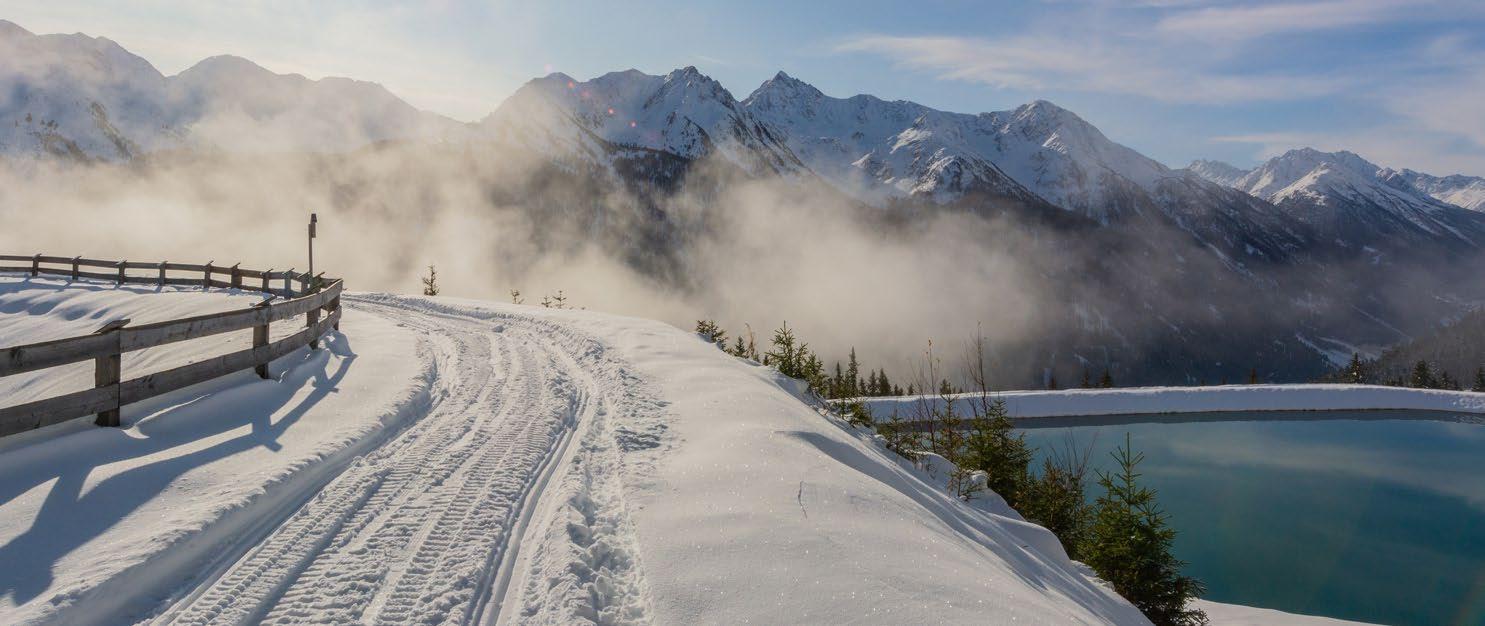
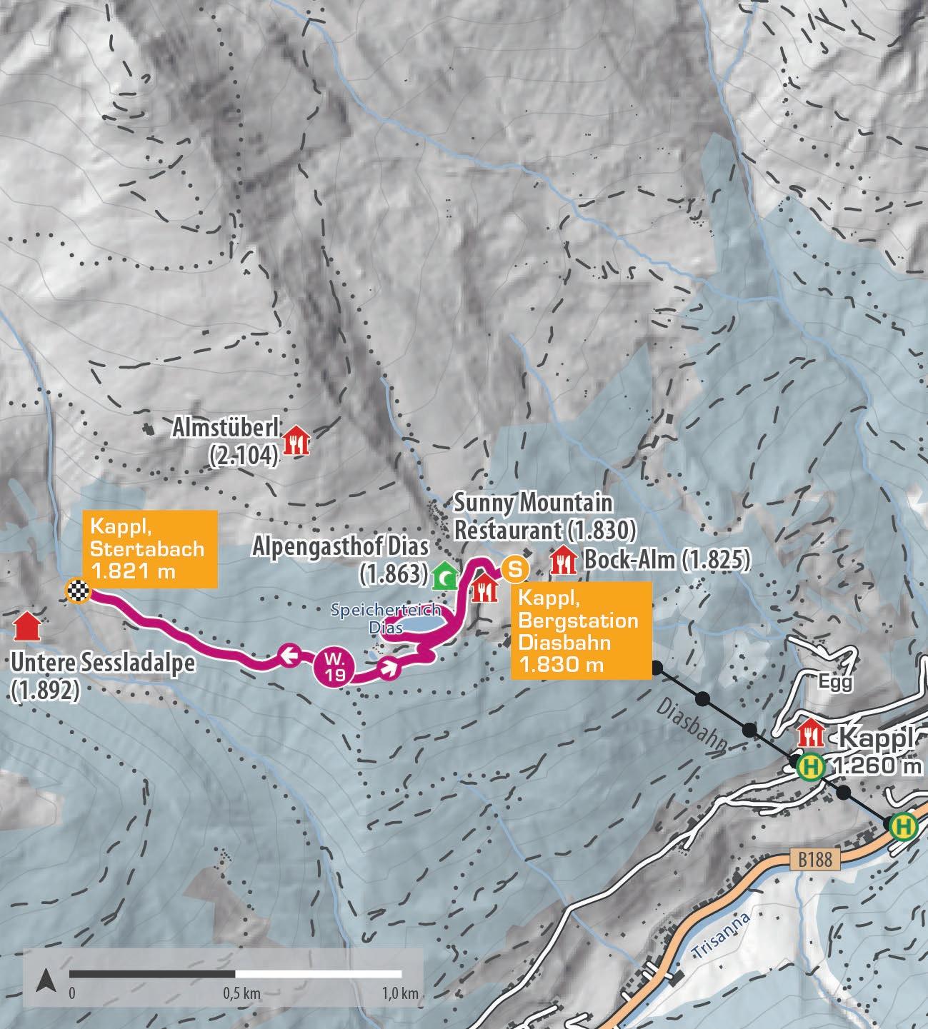
Die Tour startet an der Bergstation der Diasbahn in Kappl. Folge dem präparierten Weg unterhalb der neuen Pumpstation entlang des Damms des neuen Speicherteichs. Nach etwa einer halben Stunde erreichst du den Endpunkt der Wanderung und gehst denselben Weg zurück. Diese ruhige und gemütliche Tour ist ideal für Genießer. Wer mag, kann vorab eine kurze Runde um den oberen Speicherteich drehen, wo Bänke zum Entspannen einladen. Der Weg kann auch über den Winterwanderweg Sesslad erweitert werden.
The hike begins at the Diasbahn mountain station in Kappl. Follow the groomed path below the new pump station along the dam of the new reservoir. After about half an hour, you’ll reach the end of the trail and return the same way. This peaceful and leisurely tour is perfect for those who enjoy a relaxed pace. If you like, you can take a short detour around the upper reservoir before starting the main hike – it‘s worth it, as benches invite you to relax. The route can also be extended via the Sesslad winter hiking trail.
Start | start: Kappl, Bergstation Diasbahn
Ziel | destination: Kappl, Stertabach
Einkehrmöglichkeiten | rest stops: Restaurants im Skigebiet Kappl
Schwierigkeitsgrad
level of difficulty
leicht | easy
Gehzeit walking time 2 h
Distanz distance 4,66 km
2.000 m
1.900 m
1.800 m
1.700 m
1.600 m
Kappl, Bergstation Diasbahn 1.830 m
Kappl, Stertabach 1.821 m
Kappl, Bergstation Diasbahn 1.830 m E
W.20
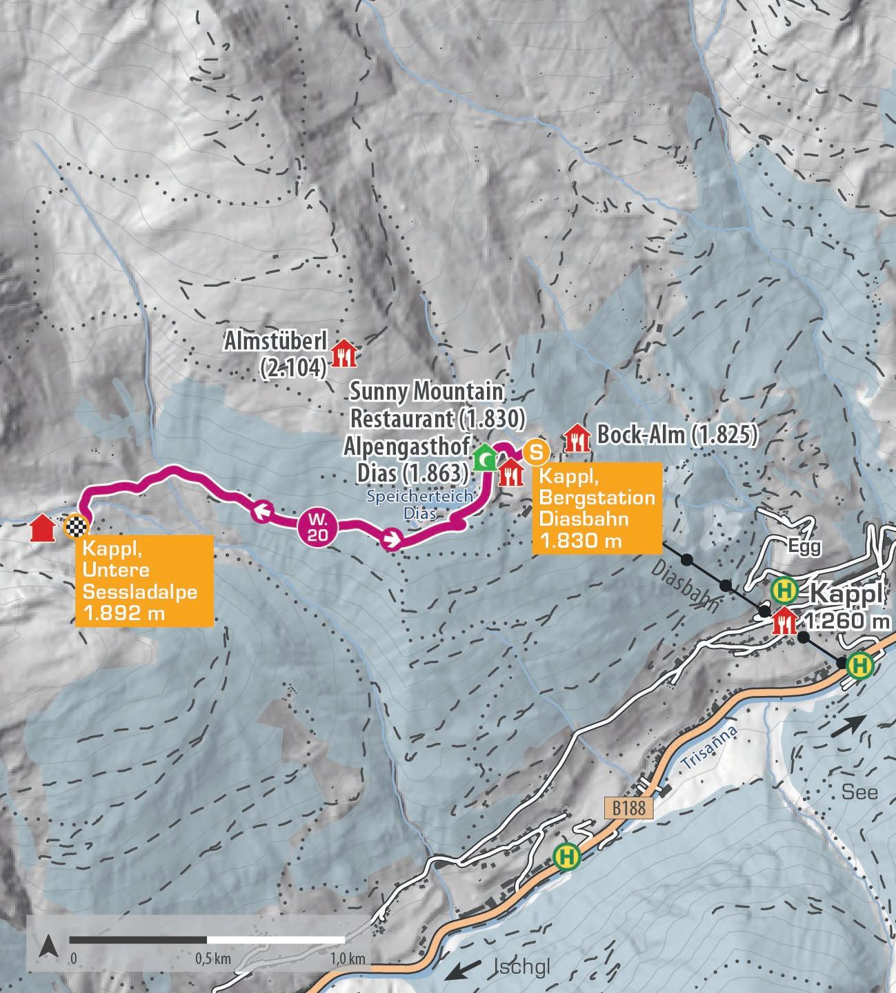
SESSLAD
Die Tour startet an der Bergstation der Diasbahn in Kappl. Zuerst folgst du dem Winterwanderweg Müllermahdlen bis Stertabach. Von dort geht es über die Schneebrücke zur unteren Sessladalpe, die im Winter nicht bewirtschaftet wird. Die Sessladalpe bietet einen wunderschönen Aussichtspunkt. Wer mag, kann vorher eine kurze Runde um den oberen Speicherteich drehen, was sich auf jeden Fall lohnt, da Bänke zum gemütlichen Entspannen einladen.
The hike begins at the Diasbahn mountain station in Kappl. First, follow the Müllermahdlen winter hiking trail to Stertabach. From there, cross the snow bridge to the lower Sessladalpe, which is not managed in winter. The Sessladalpe lodge offers a beautiful viewpoint. If you wish, you can take a short detour around the upper reservoir before starting the main hike – it‘s definitely worth it, as benches invite you to relax.
Start | start: Kappl, Bergstation Diasbahn
Ziel | destination: Kappl, Untere Sessladalpe (nicht bewirtschaftet)
Einkehrmöglichkeiten | rest stops: Restaurants im Skigebiet Kappl
Schwierigkeitsgrad level of difficulty mittelschwierig | intermediate
Gehzeit walking time 2 h
Distanz distance 4,5 km
2.000 m
1.900 m
1.800 m
1.700 m
1.600 m
Kappl, Bergstation Diasbahn 1.830 m
Kappl, Untere Sessladalpe 1.892 m
Kappl, Bergstation Diasbahn 1.830 m E
W.21
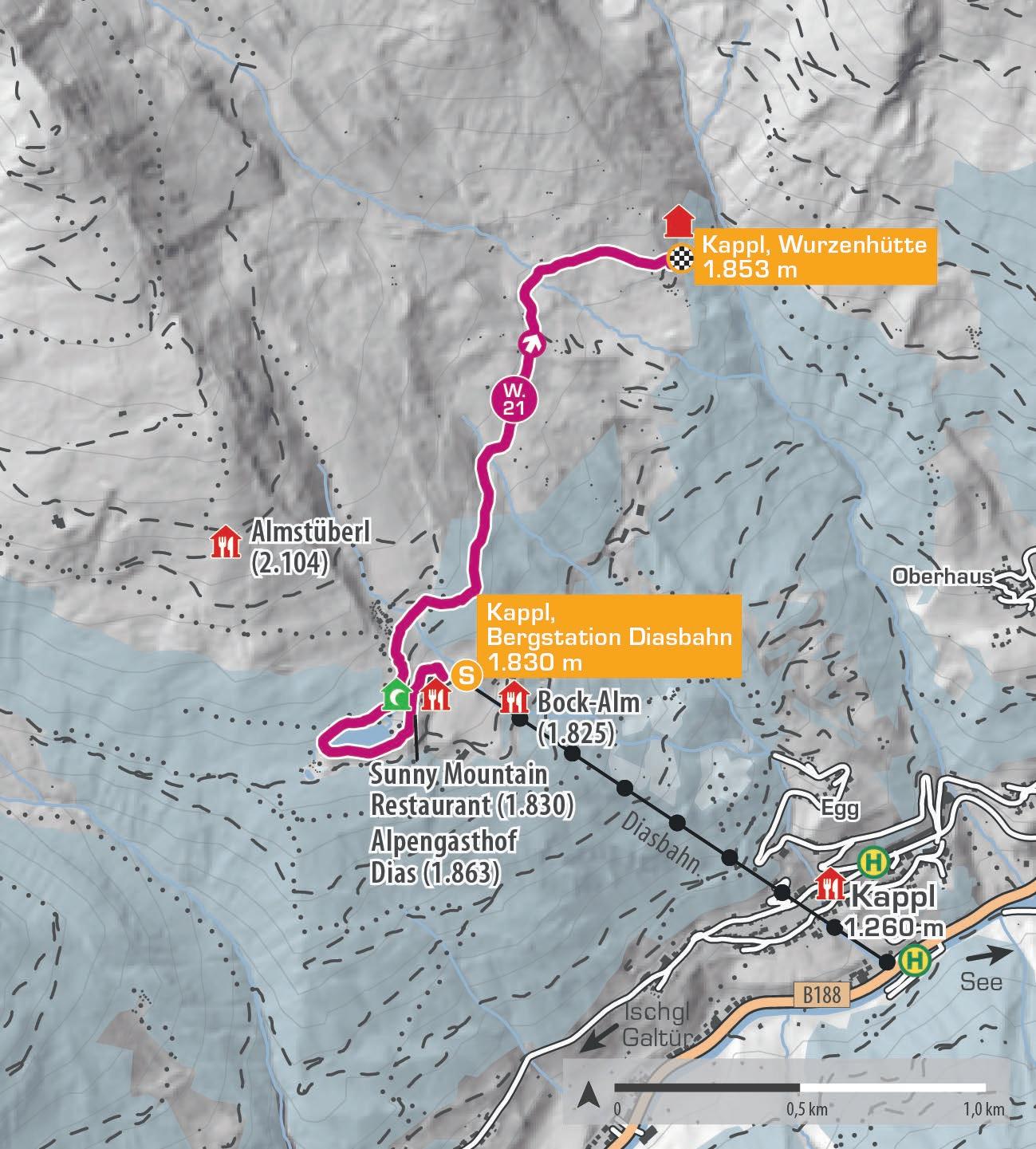
BERGWIESEN
Die Winterwanderung beginnt an der Bergstation der Diasbahn und führt in einer gemütlichen Runde um den malerischen Sunny Mountain Speicherteich. Der Weg verläuft zunächst oberhalb des Alpengasthof Dias vorbei, bevor man die Skipiste quert. Unterwegs eröffnet sich eine traumhafte Weitsicht ins Tal. Vorbei an alten, liebevoll erhaltenen Holzstadeln, die Geschichten aus vergangenen Zeiten erzählen, spürt man die Ruhe und Stille der Natur.
The winter hike starts at the Diasbahn mountain station and leads on a leisurely loop around the picturesque Sunny Mountain reservoir. The trail first passes above the Alpengasthof Dias before crossing the ski slope. Along the way, wonderful wide views open up across the valley. Passing old, lovingly preserved wooden barns that tell stories of times gone by, you can truly sense the peace and stillness of nature.
Start | start: Kappl, Bergstation Diasbahn
Ziel | destination: Kappl, Wurzenhütte (nicht bewirtschaftet)
Einkehrmöglichkeiten | rest stops: Restaurants im Skigebiet Kappl
Schwierigkeitsgrad level of difficulty mittelschwierig | intermediate
Gehzeit walking time 2 h
Distanz distance 5,1 km
2.200 m
2.000 m
1.800 m
1.600 m
Kappl, Bergstation Diasbahn 1.830 m
Kappl, Wurzenhütte 1.853 m
Kappl, Bergstation Diasbahn 1.830 m E
W.22
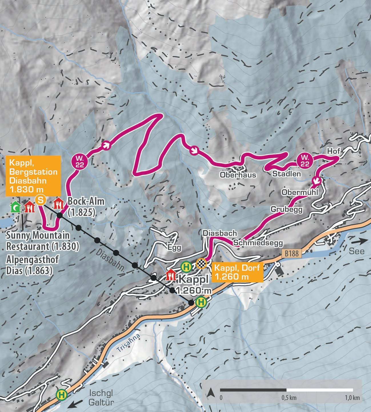
DIAS – OBERHAUS
Mit der Diasbahn fährst du gemütlich auf 1.823 Meter hinauf und wanderst von dort über Oberhaus zurück nach Kappl. Zunächst geht es entlang der Piste abwärts bis zum Rodelweg. An der ersten Kreuzung biegst du links ab und wanderst durch verschneite Wälder zur Talstation des Doppelsessellifts „Gongall“. Von hier folgst du dem Waldweg Richtung Oberhaus und weiter durch die Weiler bis ins Zentrum von Kappl. Die Tour kann auch in umgekehrter Richtung gemacht werden.
Take the Diasbahn up to 1,823 metres and hike back to Kappl via Oberhaus. The route starts by descending along the piste to the toboggan run. At the first junction, turn left and walk through snowy forests to the base of the „Gongall“ double chairlift. From here, continue on the forest path towards Oberhaus and then through the hamlets until you reach Kappl‘s centre. The hike can also be done in reverse.
Start | start: Kappl, Bergstation Diasbahn
Ziel | destination: Kappl, Dorf
Einkehrmöglichkeiten | rest stops: Restaurants im Skigebiet Kappl
Schwierigkeitsgrad
level of difficulty
leicht | easy
Gehzeit walking time 2 h
Distanz distance 6 km
2.000 m
1.800 m
1.600 m
1.400 m
1.200 m
Kappl, Bergstation Diasbahn 1.830 m
Kappl, Dorf 1.260 m
W.23
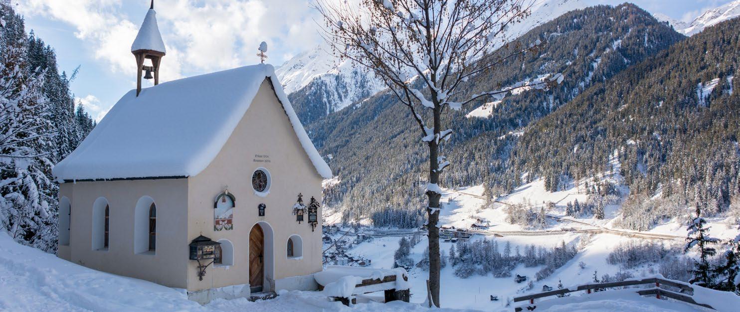
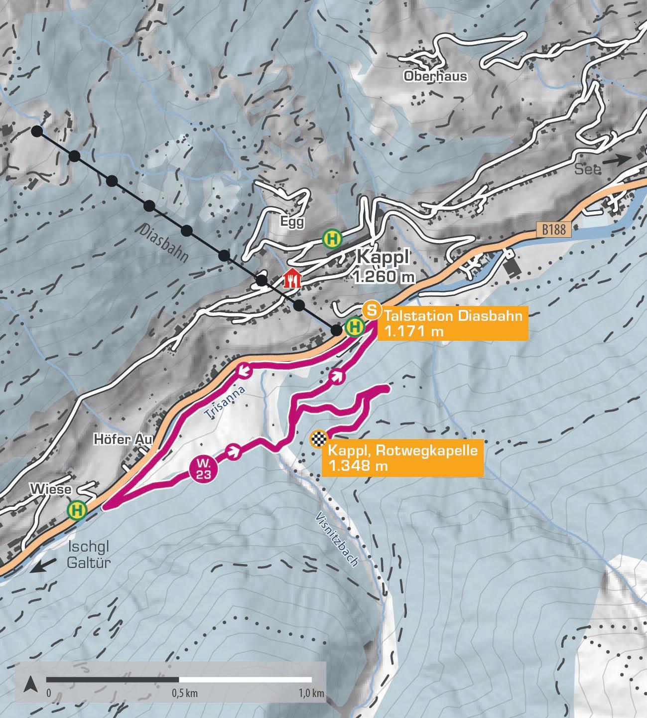
ROTWEGKAPELLE
Ausgehend von der Talstation der Diasbahn verläuft der Winterrundwanderweg entlang der Trisanna taleinwärts in Richtung Weiler Höferau. Bei drei alten Holzstadeln zweigt die Route links zur Brücke über den Visnitzbach ab. Von hier aus eröffnet sich ein schöner Blick auf den gefrorenen Visnitzwasserfall. Anschließend führt der Weg rechts über den Winterwanderweg durch die verschneite Landschaft hinauf zur Rotwegkapelle. Oben angekommen bietet sich ein herrlicher Ausblick auf das Dorf und die umliegenden Weiler. Der Rückweg verläuft rechts über die Kreuzung zur Talstation der Diasbahn.
Starting from the Diasbahn valley station, the winter circular trail follows the Trisanna river upstream towards the hamlet of Höferau. At three old wooden barns, the route branches off to the left towards the bridge over the Visnitzbach stream. From here, there is a fine view of the frozen Visnitz waterfall. The trail then continues to the right along the winter path through the snow-covered landscape up to the Rotweg Chapel. At the top, a magnificent view of the village and the surrounding hamlets opens up. To return, turn right at the intersection toward the Diasbahn valley station.
Start | start: Kappl, Talstation Diasbahn
Ziel | destination: Kappl, Rotwegkapelle
Einkehrmöglichkeiten | rest stops: Restaurants in Kappl
Schwierigkeitsgrad level of difficulty
mittelschwierig | intermediate
Gehzeit walking time 2 h
Distanz distance 4,3 km
1.600 m
1.400 m
1.200 m
1.000 m
Kappl, Talstation Diasbahn 1.171 m
Kappl, Rotweg- kapelle 1.348 m
Kappl, Talstation Diasbahn 1.171 m E
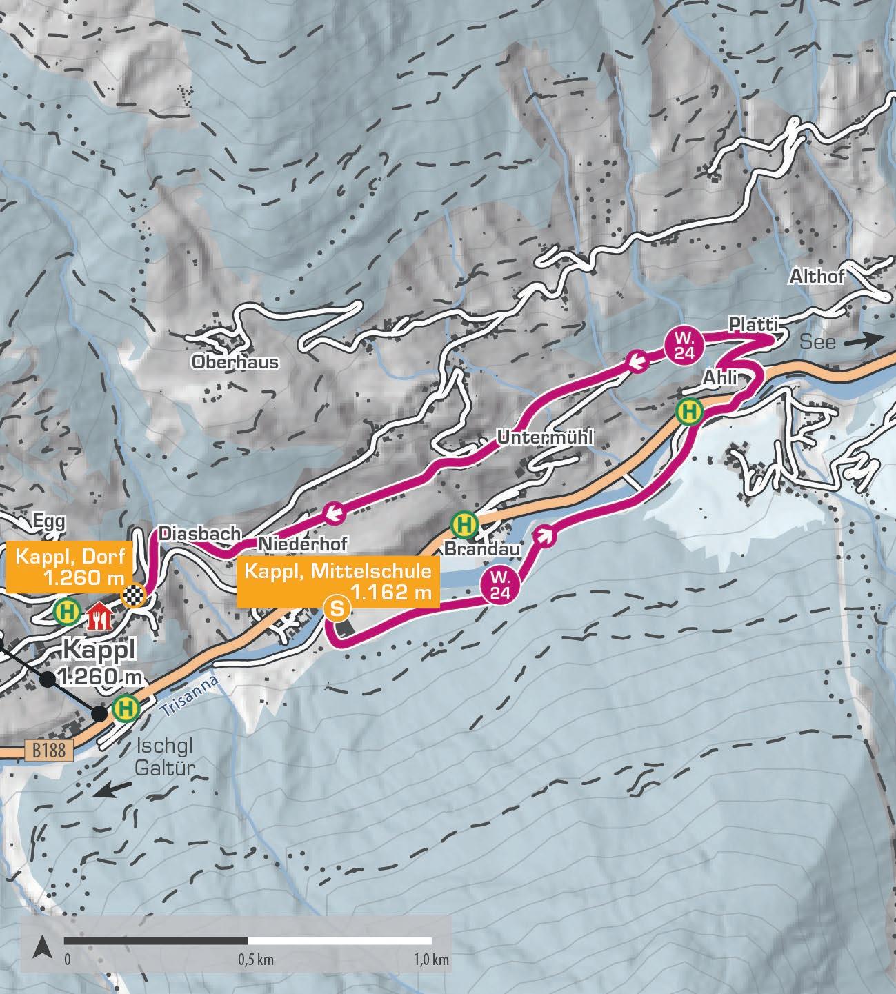
W.24
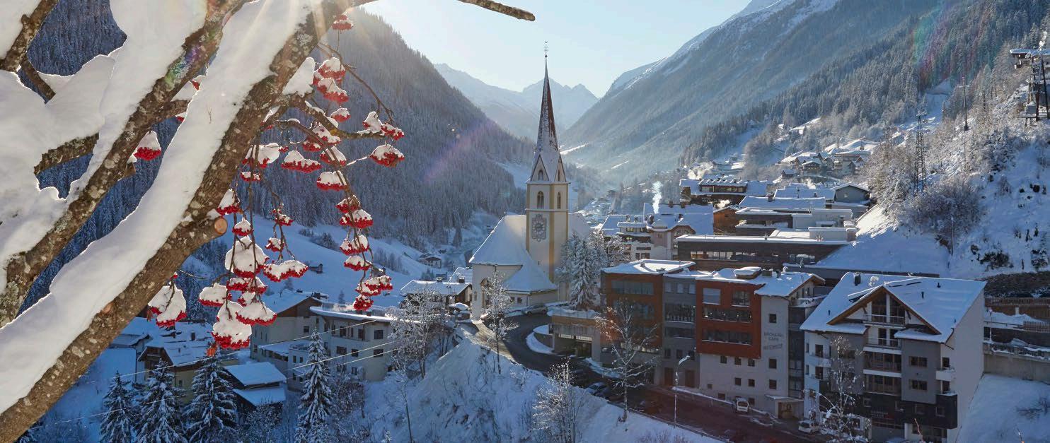
MITTELSCHULE – KAPPL DORF
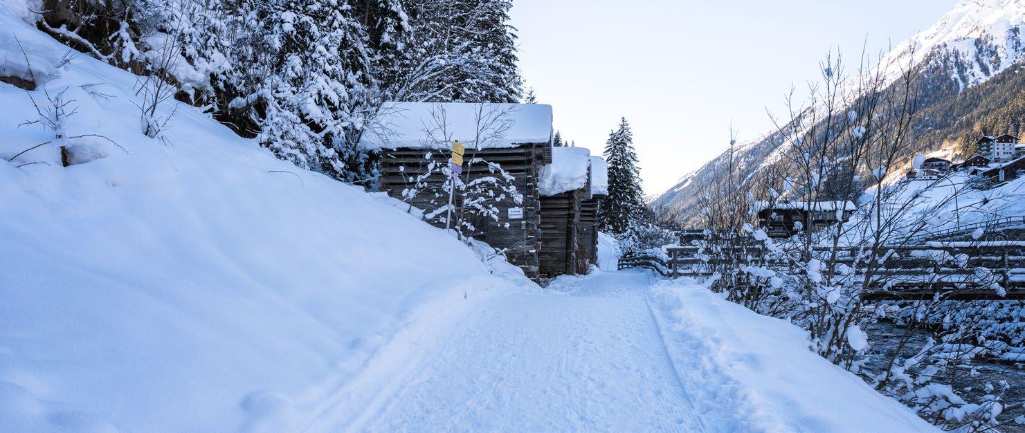
Die Wanderung startet im Weiler Lochau bei der Mittelschule. Der Winterwanderweg führt dich durch verschneite Wälder, romantische Lichtungen und vorbei an einer Wildfütterung bis zum Schützenheim, wo du wunderbar die Ruhe genießen kannst. Etwa 300 Meter nach dem Schützenheim wird die Brücke überquert und die Straßenseite gewechselt. Anschließend führt der Weg nach rund 100 Metern links in Richtung Platti. Über die asphaltierte Straße geht es weiter über Untermühl zurück ins Dorfzentrum von Kappl.
The hike starts in the hamlet of Lochau, near the middle school. This winter trail leads through snowy forests, romantic clearings, and past a wildlife feeding area until you reach the Schützenheim, where you can perfectly enjoy the peace and relax. After about 150 metres you cross the bridge and change to the other side of the road. After roughly 300 metres the path turns left towards Platti. From there, the route follows the tarmac road via Untermühl back to the village centre of Kappl.
Start | start: Kappl, Mittelschule
Ziel | destination: Kappl, Dorf
Einkehrmöglichkeiten | rest stops: Restaurants in Kappl
Schwierigkeitsgrad
level of difficulty
mittelschwierig | intermediate
Gehzeit walking time 1,5 h
Distanz distance 4 km
1.400 m
1.300 m
1.200 m
1.100 m
1.000 m
Kappl, Mittelschule 1.162 m
W.25
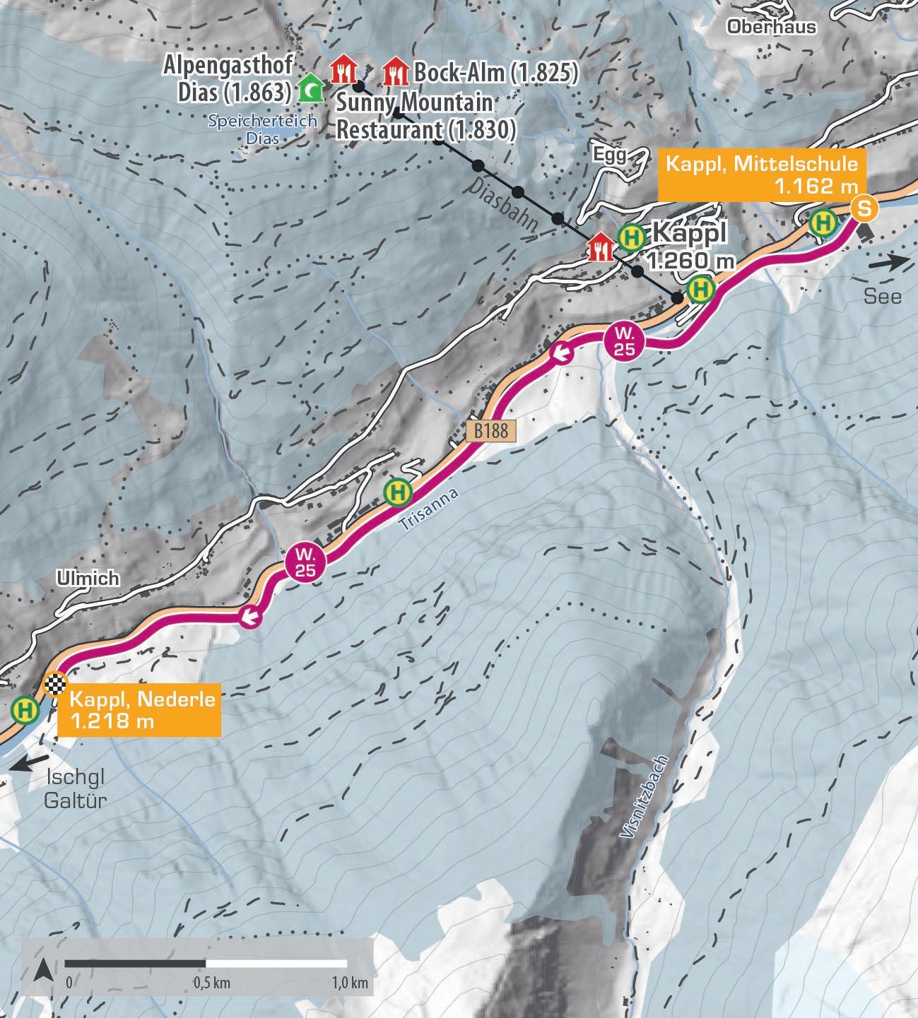
MITTELSCHULE – NEDERLE
Von der Schule im Weiler Lochau führt der Weg taleinwärts entlang der Trisanna, vorbei an den Bergbahnen Kappl. Danach verläuft die Route durch die Ortsteile Höferau und Sinsner Au, bis nach dem Hotel Höllroah der Weiler Nederle erreicht wird. Die Rückkehr nach Kappl Dorf erfolgt bequem mit dem Bus oder alternativ zu Fuß auf derselben Strecke.
From the school in the hamlet of Lochau, the trail leads up the valley along the Trisanna river, passing the Diasbahn valley station. It then continues through Höferau and Sinsner Au before reaching the hamlet of Nederle after the Hotel Höllroah. The return to Kappl village can be made conveniently by bus or alternatively on foot along the same route.
Start | start: Kappl, Mittelschule
Ziel | destination: Kappl, Nederle
Einkehrmöglichkeiten | rest stops: Restaurants in Kappl
Schwierigkeitsgrad
level of difficulty
leicht | easy
Gehzeit walking time 1,5 h
Distanz distance 3,5 km
1.400 m
1.300 m
1.200 m
1.100 m
1.000 m
Kappl, Mittelschule 1.162 m
Kappl, Nederle 1.218 m
W.26
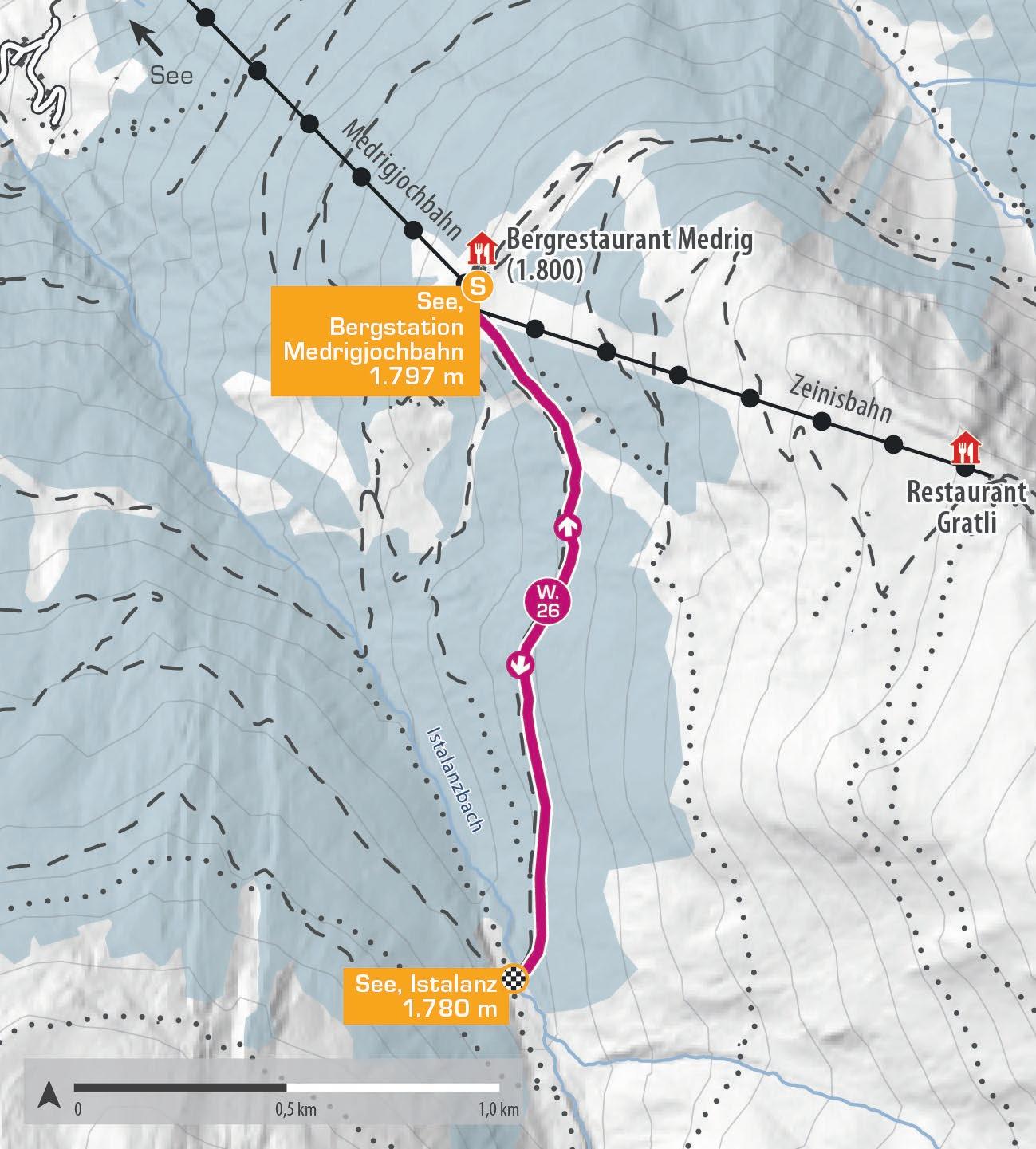
ISTALANZ
Die Tour startet an der Bergstation der Medrigjochbahn in See. Der idyllische Winterwanderweg führt ins südwestlich gelegene Istalanztal bis zum Istalanzbach. Der Weg ist über das Skigebiet erreichbar, führt aber nach kurzer Strecke abseits der Pisten. Der Rückweg erfolgt auf derselben Strecke. Hinweis: Bitte den Pistenrand nutzen, hintereinander gehen, Hunde anleinen und Kreuzungen schnell überqueren.
The hike begins at the Medrigjochbahn mountain station in See. This idyllic winter hiking trail leads into the southwest Istalanztal valley, ending at the Istalanzbach stream. The route is accessible via the ski area but soon diverges away from the slopes. The return is along the same path. Note: Please stay at the piste edge, walk in single file, keep dogs on a leash, and quickly cross any intersections.
Start | start: See, Bergstation Medrigjochbahn
Ziel | destination: See, Istalanz
Einkehrmöglichkeiten | rest stops: Panoramarestaurant
Schwierigkeitsgrad level of difficulty
mittelschwierig | intermediate
2.000 m
1.900 m
1.800 m
1.700 m
1.600 m
See, Bergstation Medrigjochbahn 1.797 m
See, Istalanz 1.780 m
See, Bergstation Medrigjochbahn 1.797 m E

W.27
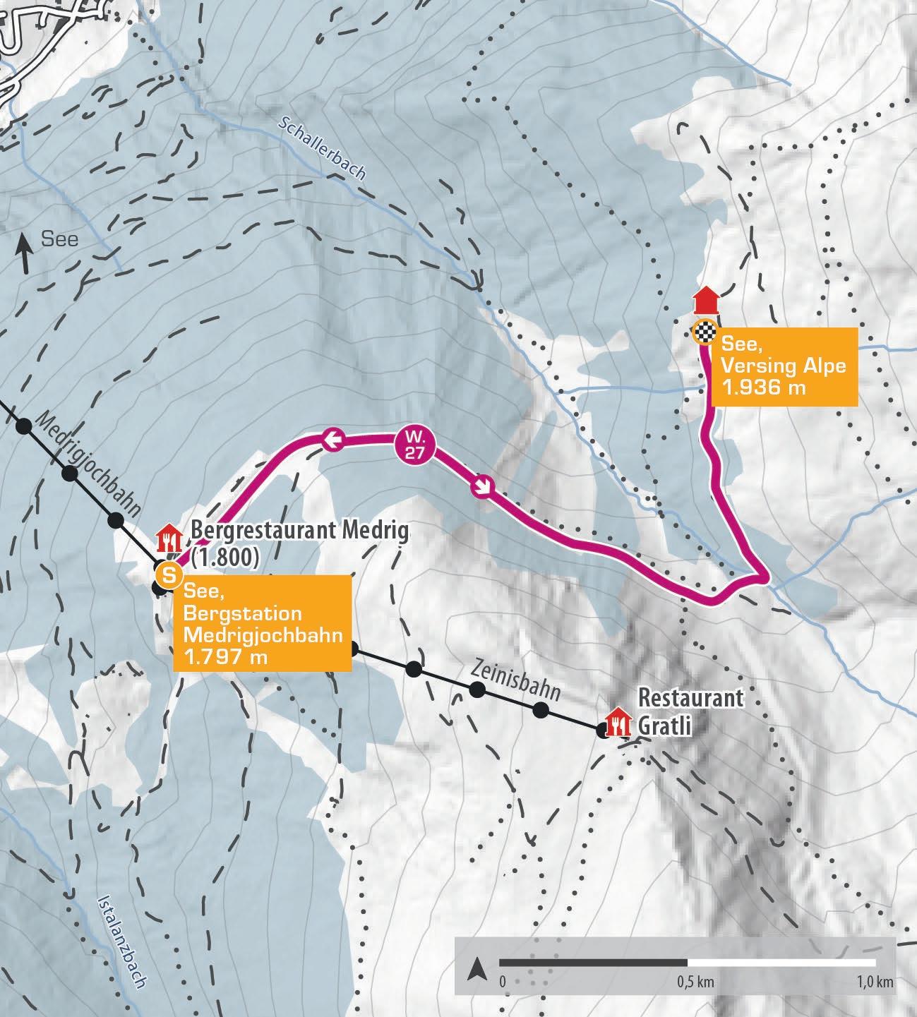
VERSING
Pures Winterwanderglück in herrlich ruhiger Umgebung erwartet Naturliebhaber auf der Tour zur Versing Alpe. Die Strecke beginnt am Förderband, das Wanderer zum Übungsgelände für Skianfänger bringt. Von dort führt ein gekennzeichneter Weg entlang der Piste 30 zur Talstation der Versingbahn. Der letzte Teil der Wanderung verläuft abseits der Pisten bis zur Versing Alpe, die im Winter im Winterschlaf liegt. Hier genießen Naturliebhaber die absolute Ruhe und die idyllische Winterlandschaft. Hinweis: Bitte den Pistenrand nutzen, hintereinander gehen, Hunde anleinen und Kreuzungen schnell überqueren.
Pure winter hiking bliss in a wonderfully peaceful setting awaits nature lovers on the tour to Versing Alpe lodge. The route starts at the conveyor belt that takes walkers to the beginner’s ski area. From there, a marked path leads along piste 30 to the valley station of the Versingbahn. The final part of the hike takes you off the slopes to the Versing Alpe lodge, which lies dormant in winter. Here, nature lovers can enjoy the absolute tranquility and the idyllic winter landscape. Note: Please stay at the piste edge, walk in single file, keep dogs on a leash, and quickly cross any intersections
Start | start: See, Bergstation Medrigjochbahn
Ziel | destination: See, Versing Alpe
Einkehrmöglichkeiten | rest stops: Panoramarestaurant, Ascher Hütte
Schwierigkeitsgrad
level of difficulty
leicht | easy
Gehzeit
walking time 2 h
Distanz distance 5 km
2.100 m
2.000 m
1.900 m
1.800 m
1.700 m
See, Bergstation Medrigjochbahn 1.797 m
See, Versing Alpe 1.936 m
See, Bergstation Medrigjochbahn 1.797 m E
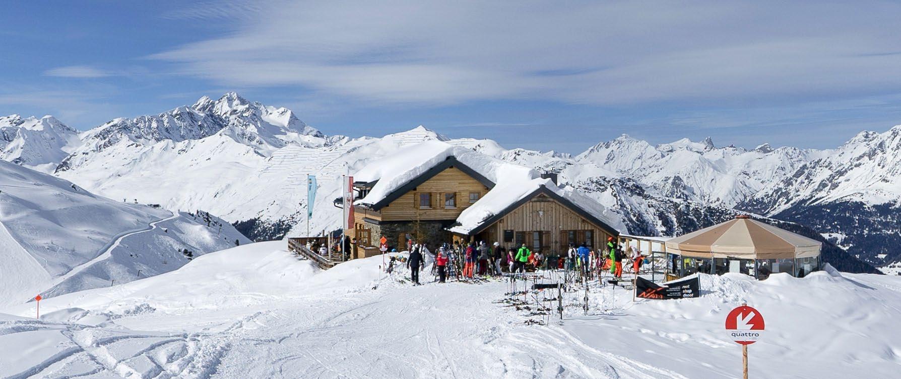
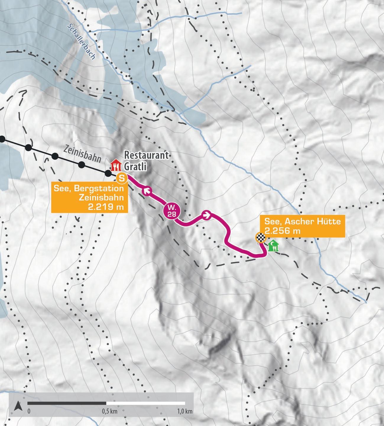
ASCHER HÜTTE
Eine willkommene Abwechslung zum Skifahren ist die Winterwanderung zur Ascher Hütte. Mit der Medrigjochbahn und der Zeinisbahn gelangst du bequem zum Ausgangspunkt. Ab der Bergstation der Zeinisbahn beginnt die aussichtsreiche Tour. Entlang der Piste 32 spazieren Naturfreunde auf gekennzeichneten Wegen gemütlich zur Talstation Furglerblick und weiter auf der Piste 30 bis zur Ascher Hütte. Oben beeindruckt der Blick auf die Verwallgruppe mit dem Hohen Riffler (3.168 m). Der Rückweg erfolgt auf demselben Weg. Hinweis: Bitte den Pistenrand nutzen, hintereinander gehen, Hunde anleinen und Kreuzungen schnell überqueren.
The winter hike to the Ascher Hütte lodge offers a pleasant break from skiing. Take the Medrigjochbahn and Zeinisbahn to reach the starting point. The tour begins at the Zeinisbahn mountain station. Follow the marked path along piste 32 to the Furglerblick valley station and continue on piste 30 to the Ascher Hütte lodge. The view of the Verwall group with the Hoher Riffler (3,168 m) is stunning. Return the same way. Note: Please stay at the piste edge, walk in single file, keep dogs on a leash, and quickly cross any intersections.
Start | start: See, Bergstation Zeinisbahn
Ziel | destination: See, Ascher Hütte
Einkehrmöglichkeiten | rest stops: Panoramarestaurant, Ascher Hütte, Restaurant Gratli W.28
Schwierigkeitsgrad level of difficulty
mittelschwierig | intermediate
2.400 m
2.300 m
2.200 m
2.100 m
2.000 m
See, Bergstation Zeinisbahn 2.219 m
See, Ascher Hütte 2.256 m
See, Bergstation Zeinisbahn 2.219 m E
S.01
SCHNEESCHUHROUTE SILVAPARK
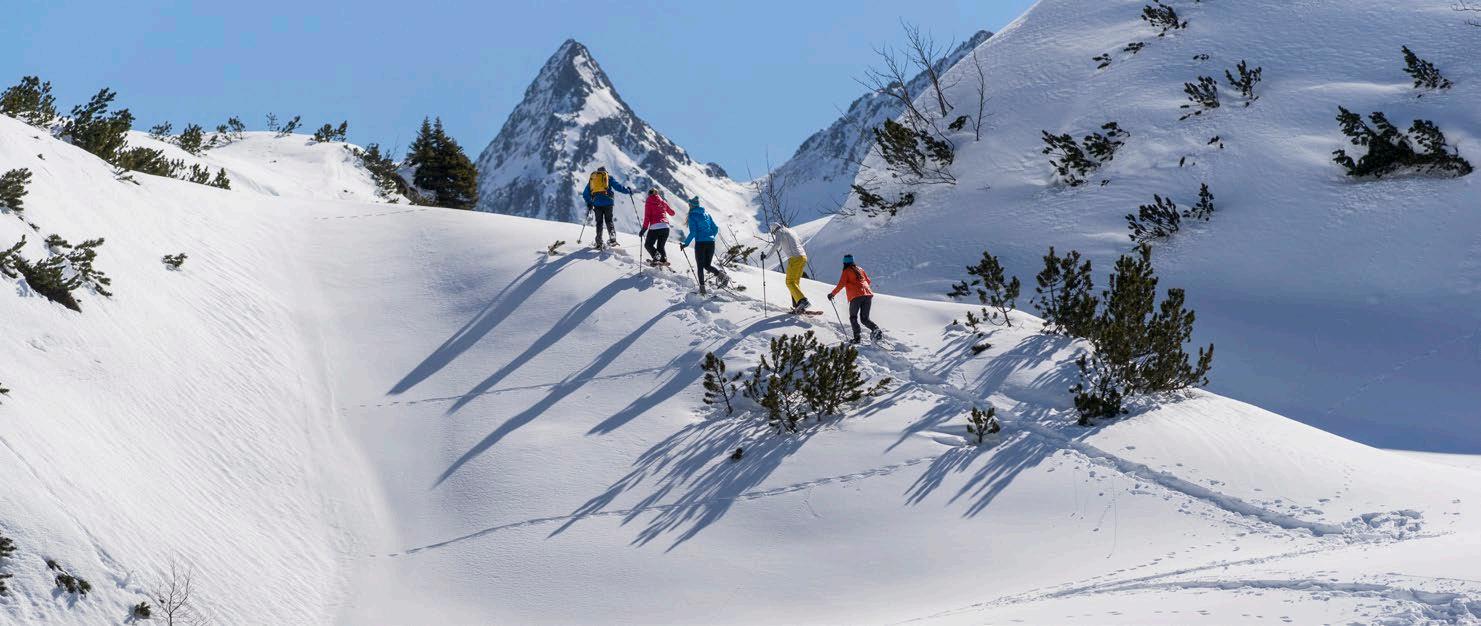
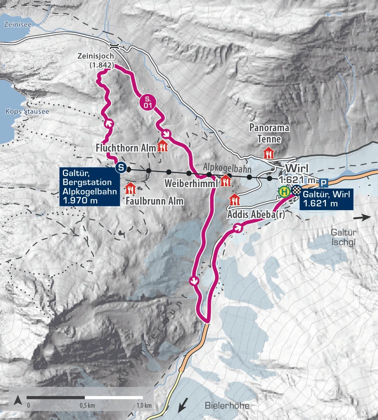
Die Schneeschuhwanderung im Silvapark Galtür startet an der Bergstation der Alpkogelbahn. Die etwa zwei Kilometer lange, ausgeschilderte Route führt durch eine malerische Winterlandschaft und verbindet die Gebirgsgruppen Silvretta und Verwall. Wunderschöne Ausblicke auf den Kops Stausee und die umliegenden Berge machen diese Wanderung zu einem besonderen Erlebnis. Ein Winterwanderweg verläuft bis zum Zielpunkt in Wirl.
The snowshoe hike in the Silvapark Galtür begins at the mountain station of the Alpkogelbahn. The approximately two-kilometer marked route takes snowshoe hikers through a picturesque winter landscape, linking the Silvretta and Verwall mountain ranges. Stunning views of the Kops reservoir and the surrounding mountains make this hike a unique experience. The winter hiking trail continues to the endpoint in Wirl.
Start | start: Galtür, Bergstation Alpkogelbahn
Ziel | destination: Galtür, Wirl
Einkehrmöglichkeiten | rest stops: Restaurants im Silvapark
Schwierigkeitsgrad level of difficulty
mittelschwierig | intermediate
Gehzeit walking time 3 h
Distanz distance 5,5 km
2.200 m
2.000 m
1.800 m
1.600 m
1.400 m
S.02
SCHNEESCHUHROUTE BÄRENTAL
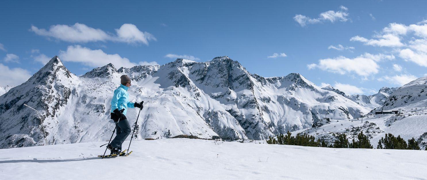
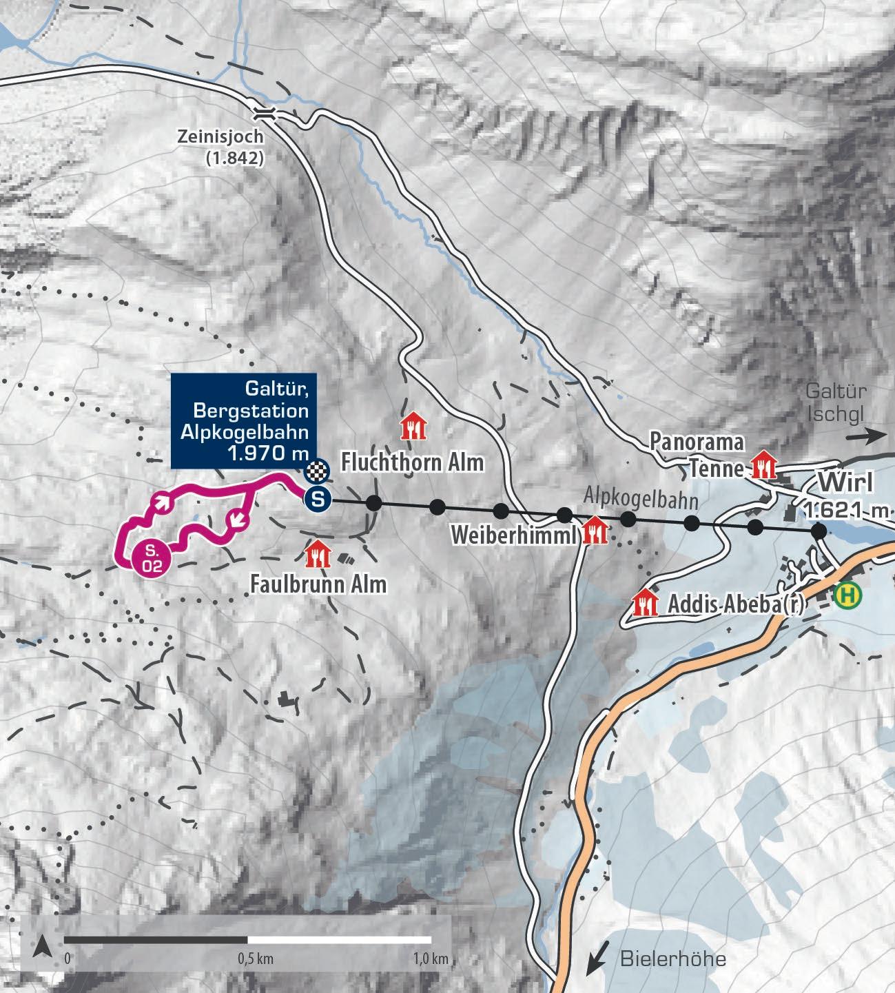
Die Schneeschuhroute Bärental bietet für Einsteiger eine idyllische Schneeschuhrundwanderung inmitten des Silvaparks Galtür. Vom Ausgangspunkt bei der Bergstation der Alpkogelbahn führt die Tour in rund einer Stunde Gehzeit vorbei an beeindruckenden Boulderblöcken und eröffnet einen traumhaften Blick auf den Kops Stausee. Ein Rastplatz entlang der Route bietet Gelegenheit für eine kurze Verschnaufpause und rundet das Naturerlebnis in der verschneiten Winterlandschaft ab.
The Bärental snowshoe route offers beginners an idyllic snowshoe circular hike in the middle of the Silvapark Galtür. From the starting point at the Alpkogelbahn mountain station, the tour takes around one hour to walk past impressive boulder blocks and offers a fantastic view of the Kops reservoir. A rest area along the route offers the opportunity for a short breather and rounds off the nature experience in the snowcovered winter landscape.
Start | start: Galtür, Bergstation Alpkogelbahn
Ziel | destination: Galtür, Bergstation Alpkogelbahn
Einkehrmöglichkeiten | rest stops: Restaurants im Silvapark
Schwierigkeitsgrad level of difficulty
leicht | easy
Gehzeit walking time 1 h
Distanz distance 1,5 km
2.200 m
2.100 m
2.000 m
1.900 m
1.800 m
Galtür, Bergstation Alpkogelbahn 1.970 m
Galtür, Bergstation Alpkogelbahn 1.970 m
S.03
SCHNEESCHUHROUTE DIAS
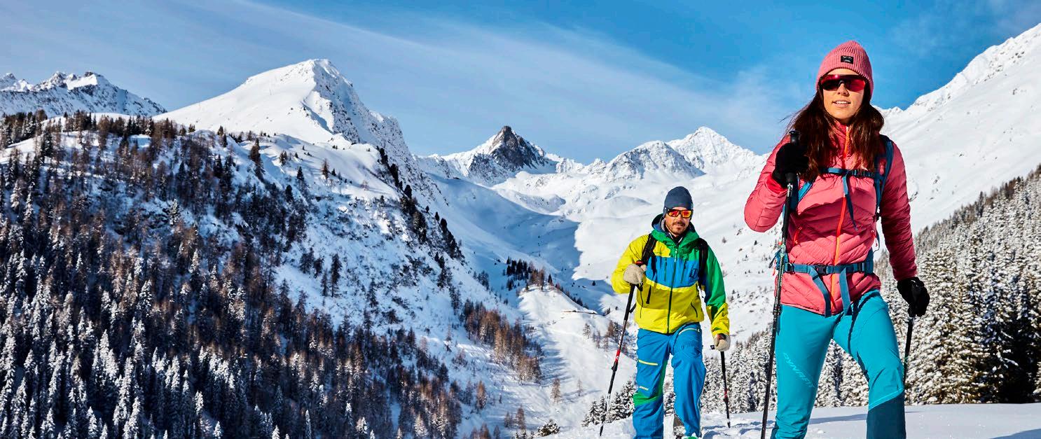
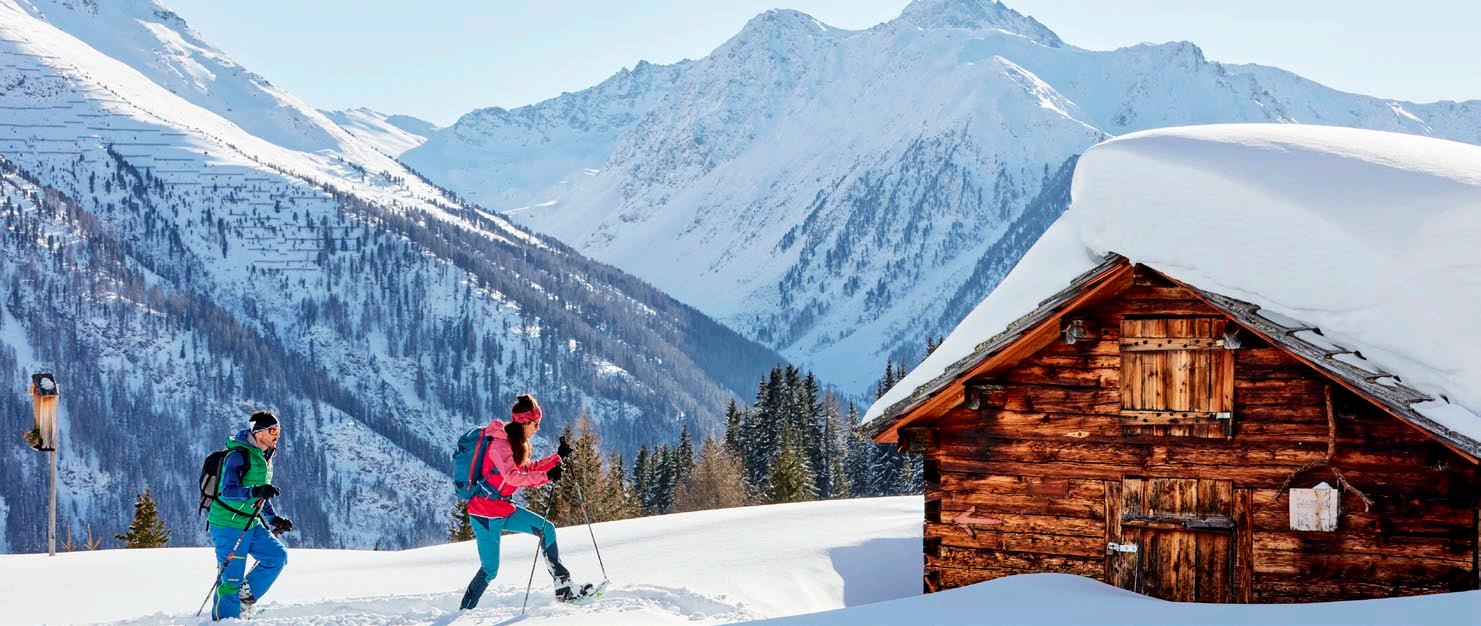
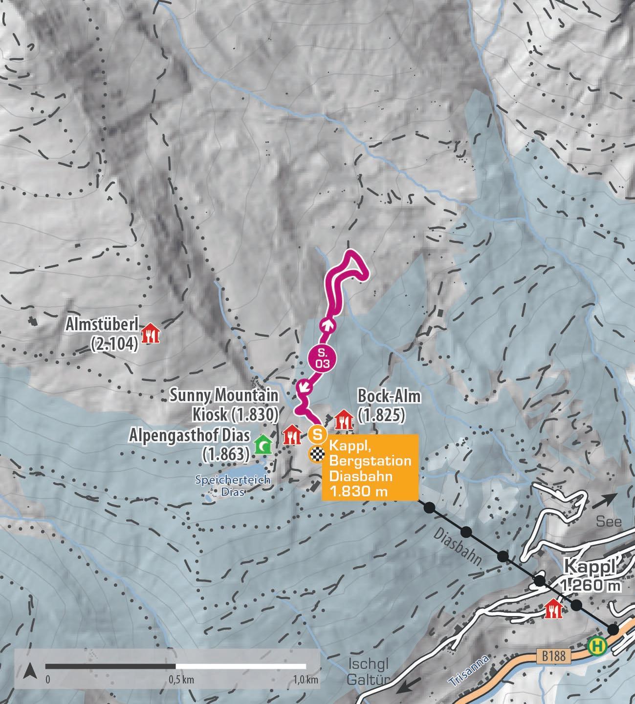
Die Schneeschuhrundwanderung startet an der Bergstation der Diasbahn. Die beschilderte Schneeschuhroute führt zunächst entlang des Fahrweges zu einem ruhig gelegenen Holzstadel, der sich perfekt für eine Pause anbietet. Hier kannst du die herrliche Aussicht auf die winterliche Bergwelt von Kappl genießen. Der Rückweg bringt dich zurück zur Bergstation der Diasbahn, wo das Sunny Mountain Restaurant zum Verweilen einlädt.
The snowshoe circular hike begins at the Diasbahn mountain station. The marked snowshoe route first follows the path to a quietly situated wooden barn, an ideal spot for a break to enjoy the stunning view of Kappl‘s winter mountains. The return route leads back to the Diasbahn, where the Sunny Mountain Restaurant invites you to relax.
Start | start: Kappl, Bergstation Diasbahn
Ziel | destination: Kappl, Bergstation Diasbahn
Einkehrmöglichkeiten | rest stops: Restaurants im Skigebiet Kappl
Schwierigkeitsgrad level of difficulty mittelschwierig | intermediate
Gehzeit walking time 1,5 h
Distanz distance 1,8 km
2.200 m
2.000 m
1.800 m
1.600 m
Kappl, Bergstation Diasbahn 1.830 m
Kappl, Bergstation Diasbahn 1.830 m
Dorfstraße 43 | 6561 Ischgl | Austria
Т +43 50990 | info@paznaun-ischgl.com galtuer.com | ischgl.com | kappl.com | see.at


