
International Research Journal of Engineering and Technology (IRJET) e-ISSN:2395-0056
Volume:12Issue:04|Apr2025 www.irjet.net p-ISSN:2395-0072
![]()

International Research Journal of Engineering and Technology (IRJET) e-ISSN:2395-0056
Volume:12Issue:04|Apr2025 www.irjet.net p-ISSN:2395-0072
Mayank Dinesh Mehta1
1Student, Independent Researcher, Surat, India
Abstract - Sensor fusion is a fundamental enabler of autonomous systems, allowing for enhanced perception, localization, and decision-making by integrating data from diverse sensor sources. This paper provides a comprehensive overview of sensor fusion techniques utilized in autonomous vehicles, unmanned aerial systems (UAS), and robotic platforms. It examines fusion strategies at various levels low-level (data), mid-level (feature), and high-level (decision) and evaluates their effectiveness in improving system reliability, environmental awareness, and operational safety. The integration of sensors such as LiDAR, radar, cameras, GPS, and inertial measurement units (IMUs) is discussed, with a focus on their complementary strengths. Key challenges including time synchronization, sensor calibration, computational efficiency, and uncertainty modeling are analyzed. The paper also highlights the role of machine learning and deep learning in advancing adaptive and context-aware sensor fusion frameworks. Emerging trends and future research directions are presented to guide the ongoing development of intelligent autonomous systems.
Key Words: Sensor fusion, Autonomous systems, IMU, LiDAR, Radar, Data Integration, Machine Learning, Robotics, Unmanned vehicles, localization, decisionmaking.
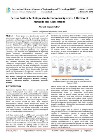
Autonomous systems have become a cornerstone of modern technological innovation, with applications spanning autonomous vehicles, unmanned aerial vehicles (UAVs),mobilerobotics,andindustrialautomation.Atthe heart of these systems lies the need for accurate perception, localization, and decision-making capabilities, which are heavily reliant on input from multiple heterogeneous sensors. Sensor fusion the process of integrating data from multiple sensors to produce more consistent, accurate, and reliable information than could be achieved by using a single sensor alone has emerged asacriticaltechnologyinthisdomain[1].
Individualsensors,suchasLiDAR,radar,cameras,inertial measurement units (IMUs), and GPS, each have their own strengths and weaknesses. For example, LiDAR provides precise 3D spatial information, but it may struggle in adverseweatherconditions;camerasofferrichcontextual data but are sensitive to lighting; radar is robust to environmental variations but typically lacks spatial
resolution. By combining data from these sources, sensor fusion techniques enable autonomous systems to operate more safely and effectively across a wide range of conditions [2], [3]. As autonomous systems become more prevalentinreal-worldapplications,theneedforefficient, reliable, and scalable sensor fusion methods continues to grow. This review aims to provide a structured overview of existing sensor fusion techniques, evaluate their performance across various domains, and identify open researchchallengesandfuturedirections.

Sensor fusion can be categorized into different levels based on the stage at which integration occurs: low-level (data-level), mid-level (feature-level), and high-level (decision-level) fusion [4]. Traditional model-based methods, such as Kalman filters, particle filters, and Bayesian networks, have long been the foundation of sensor fusion in navigation and tracking. More recently, data-driven approaches using machine learning and deep learninghavegainedprominencefortheirabilitytomodel complex,non-linearrelationshipsinsensordataandadapt todynamicenvironments[5].
This review paper aims to provide a comprehensive analysisofthestate-of-the-artinsensorfusiontechniques applied to autonomous systems. It surveys existing methodologies, compares their advantages and limitations, and explores their practical implementation across various platforms. In addition, the paper identifies ongoing challenges such as sensor calibration, time synchronization,computationalefficiency,anduncertainty modelling and outlines potential directions for future researchanddevelopment.

International Research Journal of Engineering and Technology (IRJET) e-ISSN:2395-0056
Volume:12Issue:04|Apr2025 www.irjet.net p-ISSN:2395-0072

2. Sensor Fusion: Fundamentals and Classification
Sensor fusion refers to the process of combining information from multiple sensors to derive a more accurate,reliable,andcomprehensiveunderstandingofan environment or system than what could be achieved by usingindividualsensorsalone.Thisprocessplaysacrucial role in autonomous systems, where robust situational awareness is vital for navigation, decision-making, and safetyinuncertainordynamicenvironments[6].
Thecoreobjectiveofsensorfusionistoreduceuncertainty, increase redundancy, and exploit the complementary nature of various sensor types. For example, LiDAR provides precise distance measurementsand 3D mapping, while cameras offer rich semantic content, and radar performs well under poor visibility conditions. By fusing datafromthesesensors,thesystemgainsimprovedspatial resolution, depth estimation, and robustness to noise or environmentalvariation[7].
2.1FundamentalsofSensorFusion
Sensor fusion systems typically follow a processing pipeline that involves sensor data acquisition, preprocessing (e.g., noise filtering, calibration), data alignment (e.g., time and spatial synchronization), fusion processing, and output interpretation. The fusion process canbeeithermodel-based,usingpredefinedmathematical models(e.g.,Kalmanfilters,particlefilters),ordata-driven, using machine learning techniques such as deep neural networksorprobabilisticgraphicalmodels[8].
Keychallengesinsensorfusionincludedealingwith:
Sensornoiseandbias
Latencyandsynchronization
Dataheterogeneity(differentformats,resolutions, orsamplingrates)
Computationalcomplexityinreal-timesystems
Uncertainty and conflict resolution between sensorreadings.
Sensor fusion methods are commonly classified based on thestageatwhichfusionoccursintheprocessingpipeline:
Low-Level Fusion (Data-Level Fusion): Thisapproachfusesrawdatafromsensorsbefore anyfeatureextraction.Itoffersthehighestlevelof detail but demands accurate calibration and synchronization. An example is combining LiDAR point clouds and camera pixels to generate coloured3Dmaps[9].
Mid-Level Fusion (Feature-Level Fusion): Here, features are extracted from each sensor independently, and then combined for further processing. This method reduces data dimensionality and aligns well with machine learning pipelines (e.g., combining edges from cameraimagesandradardetections)[10].
High-Level Fusion (Decision-Level Fusion): In this approach, decisions (e.g., object classifications) made by individual sensors are fused to reach a final consensus. It is robust and computationally efficient but may lose granular informationfromtherawdata[11].
Some researchers also classify fusion methods by algorithmtype:
Deterministicmethods(e.g.,Kalmanfilters)
Probabilisticmethods(e.g.,Bayesianinference)
Learning-based methods (e.g., convolutional neuralnetworks,recurrentneuralnetworks)
Understanding these classifications helps guide the design of fusion architectures suitable for different applications andconstraintsinautonomoussystems.
Autonomous vehicles (AVs) rely on a suite of complementary sensors to perceive their environment, localize within it, and make safe driving decisions. Sensor technology forms the backbone of perception systems in AVs, providing the data necessary for tasks such as object detection, lane keeping, obstacle avoidance, and adaptive cruise control. No single sensor can satisfy all operational requirementsundereverycondition,whichiswhyamultisensorsetupisessential[12].

International Research Journal of Engineering and Technology (IRJET) e-ISSN:2395-0056
Volume:12Issue:04|Apr2025 www.irjet.net p-ISSN:2395-0072
3.1CommonSensorTypes
LiDAR (Light Detection and Ranging):
LiDAR useslaser pulsestomeasure distances and createhigh-resolution3Dmapsofthesurrounding environment. It is particularly effective for detecting shapes, edges, and objects in a scene with high spatial accuracy. However, LiDAR performance can degrade in heavy rain, fog, or snow, and it tends to be expensive and powerintensive[13].
Radar (Radio Detection and Ranging): Radar systems emit radio waves to detect the velocity and position of objects, and they excel in adverse weather or low-visibility conditions. Though they provide lower spatial resolution compared to LiDAR, radar is critical for detecting moving objects such as vehicles and pedestrians [14].
Cameras (RGB and Infrared): Cameras provide rich colour and texture information and are widely used for lane detection, traffic sign recognition, and object classification. Monocular, stereo, and infrared cameras all contribute to various aspects of perception. However, camera performance is sensitivetolightingconditionsandocclusion[15].
Ultrasonic Sensors: These are typically used for short-range applicationslikeparkingassistanceandblind-spot monitoring. They are low-cost and effective for detectingnearbyobstaclesatlowspeeds[16].
GNSS(GlobalNavigationSatelliteSystems)and IMUs (Inertial Measurement Units):
GNSS provides absolute positioning data, while IMUs offer high-frequency acceleration and orientationdata,supportingdeadreckoningwhen satellitesignalsareweakorunavailable.Together, they are used for vehicle localization and trajectoryestimation[17].
3.2SensorPlacementandIntegration
The effectiveness of these sensors depends not only on their technical specifications but also on how they are positioned and integrated within the vehicle. Sensor placement is carefully designed to maximize field of view, minimize blind spots, and reduce interference. Fusion of sensor outputs is typically implemented through centralized or distributed computing architectures, enablingreal-timeperceptionandplanning[18].
Autonomous vehicle sensor systems face multiple challenges,including:
Sensor redundancy vs. cost and power consumption.
Environmentalrobustness(e.g.,glare,rain,fog)
Calibration and synchronization across sensor modalities
Data bandwidth and real-time processing requirements
Ongoing research continues to optimize sensor combinations and develop algorithms that can enhance resilienceandreducerelianceonexpensivehardware[19].

4. Sensor Calibration and Sensor Fusion for Object Detection
Accurate object detection is fundamental to the safe operation of autonomous systems, and it relies heavily on both precise sensor calibration and effective sensor fusion. Object detection systems typically integrate data from multiple sensors such as LiDAR, cameras, and radar to identify and track dynamic and static elements in the environment. However, the success of these fusion techniques depends first on precise spatial and temporal alignment of sensor data through calibration processes [20].
4.1SensorCalibration
Sensor calibrationensures thatall sensorsin a systemare accurately aligned both spatially and temporally. Calibrationcanbecategorizedinto:
Intrinsic Calibration: Determines the internal parameters of a sensor (e.g.,cameralensdistortion,focallength).

International Research Journal of Engineering and Technology (IRJET) e-ISSN:2395-0056
Volume:12Issue:04|Apr2025 www.irjet.net p-ISSN:2395-0072
Extrinsic
Calibration:
Establishes the relative pose (translation and rotation) between sensors (e.g., LiDAR-to-camera orcamera-to-radar)[21].
For example, LiDAR-camera calibration aligns 3D point cloudswith2Dimagestoenabledenseobjectlabellingand detection. Modern calibration techniques often use checkerboard patterns, reflective targets, or mutual information-based algorithms to estimate transformations withsub-centimetreaccuracy[22].Temporalcalibrationis alsoessential,especiallywhensensorsoperateatdifferent frequenciesorexperienceclock drift,whichcanotherwise introduceseriousfusionerrors[23].
Oncesensorsarecalibrated,fusionalgorithmscancombine their outputs to improve object detection performance. Differentfusionstrategiesinclude:
Early (Low-Level) Fusion:
Raw data such as LiDAR point clouds and camera pixelsaremergedbeforefeatureextraction.While this can provide dense spatial information, it requireshighcomputationalresourcesandperfect alignment[24].
Mid-Level Fusion:
Features are extracted independently (e.g., bounding boxes from camera, object points from LiDAR), then fused to improve detection confidence. This is a popular approach in many autonomous driving stacks due to its balance of efficiencyandaccuracy[25].
Late (Decision-Level) Fusion:
Each sensor provides independent object detection results, which are then combined using rules, voting schemes, or probabilistic methods. This approach is resilient to individual sensor failures but may lack detailed spatial accuracy [26].
Fusion-based object detection methods have shown significant performance gains, particularly in challenging conditions. For instance, camera-based detectors oftenfail in low-light scenarios, while radar and LiDAR provide reliable geometry but lack semantic richness. By integratingthesemodalities,systemscanaccuratelydetect vehicles, pedestrians, cyclists, and obstacles with higher confidence[27].
4.3DeepLearning-BasedFusionModels
Recent trends involve end-to-end deep learning frameworksthatlearnoptimalfusionstrategiesfromdata. Examples include multi-modal convolutional neural
networks (CNNs) and transformer-based models that jointly process images, radar maps, and LiDAR voxels to enhanceobjectdetectioninurbanenvironments[28].

Fig -4:Thisschematicrepresentsamultiplesensorperception system,knownastheFrontalObjectPerception(FOP)-Moving ObjectDetection(MOC)module,combiningdatafromLiDAR, radar,andcamerasforobjectdetectionandtracking Source: ResearchGate
Sensor fusion techniques are pivotal to the functioning of autonomous systems, as they combine complementary information from multiple sensors to produce a more comprehensive,accurate,andreliableunderstandingofthe environment. These techniques find applications across variouscriticaltasksinautonomousvehicles,robotics,and unmannedsystems[29].
5.1.ObjectDetectionandTracking
Sensor fusion significantly improves the accuracy and reliability of object detection and tracking by merging complementarydatafrommultiplesources.
Application: Fusing LiDAR and camera data allowsautonomousvehiclestodetect,classify,and track objects more accurately, even under challengingconditionssuchaslowlightoradverse weather[30].
Example: In 3D object detection systems, LiDAR provides geometric and depth information, while camera imagery adds color and texture cues for objectclassificationinself-drivingcars.
5.2.LocalizationandMapping
Preciselocalizationiscriticalfornavigationandautonomy, particularlyinareaswhereGPSsignalsmaybeunavailable ordegraded.
Application: Sensor fusion techniques such as combining GPS, IMU, LiDAR, and visual data enable robust localization and mapping in real time. SLAM (Simultaneous Localization and

International Research Journal of Engineering and Technology (IRJET) e-ISSN:2395-0056
Volume:12Issue:04|Apr2025 www.irjet.net p-ISSN:2395-0072
Mapping) frameworks heavily rely on this fusion to build accurate maps while tracking position [31].
Example: Visual-Inertial Odometry (VIO) systems integrate camera images and IMU measurements toprovidepreciseposeestimationfordronesand mobile robots operating indoors or in GPS-denied environments.
5.3.PathPlanningandDecisionMaking
Accurate and timely environmental awareness through sensor fusion enables safer, more efficient decisionmakingandtrajectoryplanning.
Application: Radar and camera fusion helps autonomous vehicles anticipate moving obstacles (e.g., other vehicles, pedestrians) and dynamically adjusttheirplannedpaths[32].
Example: During highway merging, fusion-based systems assess surrounding vehicle trajectories and lane occupancy to execute safe merging maneuvers.
5.4.EnvironmentPerceptionandSceneUnderstanding
Advanced perception systems use sensor fusion to understand complex scenes, including recognizing traffic signals,roadmarkings,pedestrians,andvehicles.
Application: Multi-sensor fusion enables robust semantic segmentation of complex scenes, allowingrecognitionofroadelementssuchaslane markings,trafficsigns,andpedestrians[33].
Example: Autonomous shuttles use fused camera and LiDAR inputs for real-time scene parsing and passengerdetection.
5.5.SafetyandRedundancy
Sensor fusion introduces redundancy and fault tolerance into autonomous systems, enhancing safety and operationalreliability.
Application: Fusion of radar and camera systems compensates for individual sensor weaknesses. Forexample,radarcanoperateeffectivelyinpoor visibility conditions (e.g., fog or rain), where cameraperformancemightdegrade[34].
Example: Autonomous trucksutilize multi-sensor fusion to detect obstacles redundantly, ensuring continued operation even if one sensor fails or becomesunreliable.

Sensor fusion stands as a cornerstone in the evolution of autonomous systems, enabling them to perceive and interact with their environments in a reliable, accurate, and intelligent manner. This review has explored the fundamental principles of sensor fusion, its classification, andthetechnologiesinvolved rangingfromconventional filters like Kalman and particle filters to advanced deep learning-basedfusionframeworks.
The integration of diverse sensor modalities such as LiDAR,radar,cameras,GPS, and IMUs allowsautonomous platforms be it vehicles, drones, robots, or marine systems to overcome the limitations of individual sensors.Applicationsinobjectdetection,localization,path planning, environment perception, and safety are now critically dependent on the synergy offered by sensor fusiontechniques.
Despite significant advancements, challenges such as computational cost, sensor calibration, data synchronization, and robustness in dynamic or adverse environments remain open areas of research. The future ofsensorfusionwilllikelyinvolvetighterintegrationofAI models with traditional estimation techniques, greater emphasis on edge computing, and improved standardizationacrossplatforms.
In conclusion, as autonomous systems continue to proliferate in transportation, logistics, defense, and industrial automation, sensor fusion will play an increasingly vital role in ensuring safety, efficiency, and autonomyincomplexreal-worldenvironments.

International Research Journal of Engineering and Technology (IRJET) e-ISSN:2395-0056
Volume:12Issue:04|Apr2025 www.irjet.net p-ISSN:2395-0072
[1] A. Khaleghi, A. Khamis, F. O. Karray, and S. N. Razavi, “Multisensordatafusion:Areviewofthestate-of-the-art,” Information Fusion,vol.14,no.1,pp.28–44,Jan.2013.
[2] H. Cho, Y. Kim, and I. Hwang, “Real-time sensor fusion algorithmforautonomousvehiclenavigation,” IEEE Trans. Intell. Transp. Syst.,vol.19,no.2,pp.541–553,Feb.2018.
[3]D.Llorca,I.Parra,M.A.Sotelo,etal.,“Sensorfusionfor obstacledetection:Areviewofrecentworks,” Sensors,vol. 21,no.3,pp.1–27,2021.
[4] C. Luo and S. Nagarajan, “A survey of sensor fusion techniques in autonomous vehicles,” ACM Comput. Surv., vol.55,no.1,pp.1–33,Jan.2023.
[5]Z.Xu,H.Liang,andX.Li,“Deeplearningformultisensor fusion in autonomous driving: A review,” IEEE Trans. Neural Netw. Learn. Syst.,vol.34,no.1,pp.1–15,Jan.2023.
[6] A. Elmenreich, “An Introduction to Sensor Fusion,” Research Report,ViennaUniv.ofTechnology,2002
[7] M. Himmelsbach, F. Hundelshausen, and H.-J. Wuensche, “LIDAR-based 3D object perception,” in Proc. 1st Int. Workshop Cognit. Assist. Driving,2010,pp.1–7.
[8] R. E. Kalman, “A new approach to linear filtering and prediction problems,” J. Basic Eng., vol. 82, no. 1, pp. 35–45,1960.
[9]S.Thrun,W.Burgard,andD.Fox, Probabilistic Robotics, MITPress,2005.
[10] Y. Chen, C. Yang, and D. Wang, “Multisensor fusion in automated driving: A survey,” IEEE Access, vol. 8, pp. 2847–2868,2020.
[11] L. Kunze et al., “Decision-level sensor fusion in autonomous vehicles,” Robotics and Autonomous Systems, vol.92,pp.73–83,2017.
[12] SAE International, “Taxonomy and Definitions for Terms Related to Driving Automation Systems for OnRoadMotorVehicles,”SAEJ3016,2021.
[13] J. Zhang and S. Singh, “LOAM: Lidar Odometry and Mapping in Real-time,” in Robotics: Science and Systems, 2014.
[14] M. R. Hodges and C. W. Baum, “Automotive Radar Status and Trends,” IEEE Microwave Mag., vol. 18, no. 7, pp.20–22,2017.
[15] A. Geiger, P. Lenz, and R. Urtasun, “Are we ready for AutonomousDriving?TheKITTIVisionBenchmarkSuite,” in CVPR,2012.
[16] R. Bishop, Intelligent Vehicle Technology and Trends, ArtechHouse,2005.
[17] K. Jo, J. Kim, D. Kim, C. Kim, and M. Sunwoo, “Development of autonomous car Part I: Distributed system architecture and development process,” IEEE Trans. Ind. Electron.,vol.61,no.12,pp.7131–7140,2014.
[18] B. Paden et al., “A Survey of Motion Planning and Control Techniques for Self-Driving Urban Vehicles,” IEEE Trans. Intell. Veh.,vol.1,no.1,pp.33–55,2016.
[19] D. Gonzalez et al., “A Review of Motion Planning Techniques for Automated Vehicles,” IEEE Trans. Intell. Transp. Syst.,vol.17,no.4,pp.1135–1145,2016.
[20] A. Geiger, F. Moosmann, Ö. Car, and B. Schuster, “Automatic camera and range sensor calibration using a single shot,” in Proc. IEEE Int. Conf. Robot. Autom. (ICRA), 2012.
[21] Y. Pandey, G. Kellner, and S. I. Roumeliotis, “A New Calibration Method for Multi-Sensor Systems,” in Proc. IEEE/RSJ Int. Conf. Intell. Robots Syst. (IROS),2010.
[22] A. Levinson and S. Thrun, “Automatic online calibrationofcamerasandlasers,”in Robotics: Science and Systems (RSS),2013.
[23] D. Scaramuzza, A. Harati, and R. Siegwart, “Extrinsic self-calibration of a camera and a 3D laser range finder fromnaturalscenes,”in IEEE/RSJ IROS,2007.
[24]M.Liang,B.Yang,Y.Chen,andR.Urtasun,“Multi-task multi-sensor fusion for 3D object detection,” in CVPR, 2019.
[25] S. Ku, A. Harakeh, and S. Waslander, “In defense of classical image processing: Fast depth completion on the CPU,” in Proc. Conf. Comput. Vis. Pattern Recognit. (CVPR) Workshops,2018.
[26] J. Feng et al., “Multi-modal sensor fusion for object detection in autonomous driving: A review,” IEEE Trans. Intell. Transp. Syst.,vol.22,no.8,pp.5087–5106,2021.
[27]X.Chen,H.Ma,J.Wan,B.Li,andT.Xia,“Multi-view3D object detection network for autonomous driving,” in CVPR,2017.
[28]C.Liu,H.Zhan,andI.Reid,“DeepFusionofLiDARand Images for Dense Depth Prediction,” in IEEE/RSJ Int. Conf. Intell. Robots Syst.,2020.
[29] H. Durrant-Whyte and T. Bailey, "Sensor Fusion: Fundamentals and Applications," Proceedings of the IEEE, vol.95,no.5,pp.909-925,2006.

International Research Journal of Engineering and Technology (IRJET) e-ISSN:2395-0056
Volume:12Issue:04|Apr2025 www.irjet.net p-ISSN:2395-0072
[30] Chen, X., Kundu, K., Zhu, Y., Ma, H., Fidler, S., & Urtasun, R. (2017). Multi-view 3D object detection networkforautonomousdriving. IEEE CVPR,2017.
[31] Cadena, C., Carlone, L., Carrillo, H., Latif, Y., Scaramuzza, D., Neira, J., Reid, I., & Leonard, J. J. (2016). Past, present, and future of simultaneous localization and mapping: Toward the robust-perception age. IEEE Transactions on Robotics,32(6),1309–1332.
[32]Lefèvre,S.,Vasquez,D.,&Laugier,C.(2014).Asurvey on motion prediction and risk assessment for intelligent vehicles. Robotics and Autonomous Systems, 58(9), 1157–1177.
[33] Zhao, H., Shi, J., Qi, X., Wang, X., & Jia, J. (2017). Pyramidsceneparsingnetwork. IEEE CVPR,2017.
[34]Bijelic,M.,Gruber,T.,Mannan,F.,Kraus,F.,Ritter,W., Dietmayer, K., & Heide, F. (2020). Seeing through fog without seeing fog: Deep sensor fusion in the absence of labeled training data. IEEE/CVF Conference on Computer Vision and Pattern Recognition (CVPR)