International Research Journal of Engineering and Technology (IRJET) e ISSN:2395 0056

Volume: 09 Issue: 05 | May 2022 www.irjet.net p ISSN:2395 0072
International Research Journal of Engineering and Technology (IRJET) e ISSN:2395 0056
Volume: 09 Issue: 05 | May 2022 www.irjet.net p ISSN:2395 0072
1 M tech in RS& GIS Remote Sensing Application Centre, U.P, India
2 RTIS, NMCG, Ministry of Jal Shak
3Scientist SE& Head of School of Geoinformatics, Remote Sensing Application Centre, U.P. India ***
RiverGangaisnotonlytheculturalandspiritualmainstayofIndiabutalsoprovideseconomicsustenance,water,andfood security to more than 43 percent of the country’s population. A part of the collective consciousness of India, Ganga can easilybeconsideredthemostreveredriveracrosstheworld.AsarepresentationofIndia’sidentityandculture,itbecame importanttorestoretherivertoitscleanandpristineglory.Consideredthelifelineformillionsofpeople,RiverGangahas beenfacingseveralchallenges:thepollutionoftheriverfromdifferentsourceswithgrowingurbanizationandindustrial growth. On the other, the excess abstraction of water from the river for agricultural, industrial, and drinking needs. Pollution abatement measures comprehensively tackle all sources of pollution such as municipal sewage, industrial effluents, municipal solid waste, rural sanitation, non point sources of pollution such as agricultural runoff, open defecation,andun burntdeadbodies,etc.
TheUAVs(UnmannedAerialVehicles),commonlyreferredtoas‘Drones’,arenowadaysavaluableplatformforfacilitating temporal and spatial data acquisition. They have become a low cost alternative to classical aerial manned photogrammetry.Itsabilitytoaccesspreviouslyunreachable,remoteareasandcarryapayload,likeacamera,tocapture 2Dimagesisbeyondthescopeofany otherexistingtechnology.Specializedsoftwarecanconvertthesetwo dimensional images to three dimensional scalable models. This has empowered the researchers and policymakers to have a fast and holisticviewoftheareaindiscussionandexpeditedecisions.
Aerial images were processed using Image processing & GIS based software to create the Orth mosaic (2 D Data), Pointcloud(3DData),DigitalElevationModel,andMapcompositionofthestudyarea.Thisstudyaimstoacquirethedata tounderstandthepatchesofpollutionintheriverGanga,whichmaybesolidwasteandsewagedischargeinto theriver. Beforelarge scaleeffortscanbemadetopreventandcleanuppollution,itisacostandtime effectivesolutiontoidentify themajorhotspotswherethepollutionoriginates.
Keywords:UAV,Ortho,Digitalelevationmodel
TheGangaRiverisoneofthelargestriversystemsintheworldencompassingdiversehabitatcharacteristics.TheGanga basin constitutes 26% of the country’s landmass (8,61,404 sq km) and supports more than 43% of its population. The basin covers an area of 1,086,000 sq km, extending over India, Nepal, Bangladesh, and China. About 79% of the Ganga basinarealiesinIndiacovering11statesviz.,Uttarakhand,UttarPradesh,MadhyaPradesh,Rajasthan,HaryanaHimachal Pradesh,Chhattisgarh,Jharkhand,Bihar,WestBengal,andDelhi.
ItisawidespreadbeliefthattheriverGangacanpurifyallthatcameintocontactwithit.However,theriver’sexistencein termsofcleanandcontinuousflowisthreatenedduetotheintensityofhumanactivities.Humaninterventionsaredirectly or indirectly affecting the river. Anthropogenic activities have generated important transformations in rivers during the lastfewdecades.Theadvancementofhumancivilizationhasputmajorquestionsaboutthesafeuseofriverwater.River water pollution due to heavy metals is one of the major concerns in most of the cosmopolitan cities of developing countries.Heavymetalsintheriverineenvironmentrepresentanenduringthreattohumanhealth.Culturalandreligious on the banks of the river along with the tourists have been one reason for the water pollution in the river. Unwanted activities such as illegal dumping, liquid waste discharge, disposal of garbage, etc., affect the quality of the river. River Ganga has become very polluted because of speedy urbanization and industry throughout the basin. The Ganga watercourse has started losing its potency due to the big amount of untreated sewage and noxious industrial influents
International Research Journal of Engineering and Technology (IRJET) e ISSN:2395 0056
Volume: 09 Issue: 05 | May 2022 www.irjet.net p ISSN:2395 0072
dischargedintoit.WastematterandindustrialeffluentsdischargedfromcitiesdirectlosedisposalintotheriverGangaor its tributaries. Domestic and different solid waste drop directly or indirectly into the watercourse; also, the waste from hospitalsandnursinghomes,thatoughttobesuitablytreated,isdisposedofuntreatedintotheriver.Increasingdemand for water from the domestic and industrial sector is leading to the over extraction of water from the river because of whichriverwaterisdecliningasaresultofwhichconcentrationwithintheriverwaterisincreasing.Deforestationinthe watershedandtheriver’soriginbecauseofthedeforestationrateofrunoff,it's raised,resultinginincreasedpollutionin theriver.Constructionsofdamsinthechainregionandmajorconstructionwithinthecatchmentsareaalsocausehigher materialconcentrationinthewatercourse.
Withtheadvancementinspacetechnology,itisnowpossibletoemployremotesensingtechniquesforestimatingsurface and subsurface water over large areas. The necessity of remote sensing based groundwater mapping of large and unreachable areas. Remote sensing techniques provide the ideal solution for river corridor monitoring due to their non intrusive nature, wide range, spatial coverage, and repeatability. For a better understanding of river corridors, we need datathatarecontinuousovervariousscales,withremotesensingbeingtheidealsolutiontoachievethis.
Unmanned aerial vehicles (UAVs), also known as drones, have emerged as a potential alternative for mapping and monitoringwaterresources’qualityandquantity.Thisisbecausedronesareflexibleandrelativelycheaperincomparison toinsitumeasurementsandspaceborneremotesensing,andcanbeflownatlowaltitudes,offeringvery high resolution data,withhighprospectsoftimelyandaccuratelycharacterizingwaterqualityandquantityofwater. UAVscouldbeused in monitoring hazards (i.e., after floods, fires, landslides) because they can generate near real time, fine resolution, spatially explicit information. UAV generated very high resolution Digital elevation model (DEM) may be used to inspect thevalidityofclassicalcirculateandfloodplaincategorytheory,therebynownolongerhandiestsearchingatprogramsas isusuallyfinished but additionallyaugmentingourclinical knowledgeofhydrological procedures. Analyzing thebenefits of UAVs, argue that piloted plane surveys provide a feasible opportunity for satellite tv for pc structures due to the fact they supply finer spatial decision records, however, excessive fees can restrict ordinary surveys and deployments can hardly ever be commissioned at brief notice, Brazier et al [1]. Consequently, declare there may be a shortfall in cutting edge far off sensing records provision with regards to the subsequent demanding situations that cannot be met with cutting edgesatelliteorairborneimagingsurveytechnologies:
1. Cost powerful seize of excellent scale spatial records describing the cutting edge hydrological situation and water aid popularityofcatchmentsatuser describedtime steps.
2. Data seize at an excellent temporal decision for describing water gadget dynamics in soil moisture, flora, and topography in catchments in which there are vital downstream outcomes on water resources (e.g., floods, erosion activities,orfloraremoval).
ThisprojectaimstoaccumulatestatisticstoapprehendthepatchesofpollutantsintheholyriverGanga,whichcanbedry wasteandanymoistorliquidwaste.Beforehugescaleeffortsmaybemadetosaveandeaseuppollutants,wefirstneedto becomeawareofthemost importanthotspotsinwhichthepollutantsoriginate. We wouldtypicallyconducta surveyof pollutants alongside the holy river Ganga, working on the land to accumulate data, on which pollutants are coming from andinwhichitisfocusedtohigherapprehendtheproblem
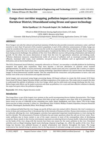
The study was conducted in Haridwar, Uttarakhand. Haridwar’s location indicates the geographical position of the north Indiancitythat'srenownedjointly amongIndia’sgreatestjourneyingsites.Haridwar cityissitedinitsdistrict. Haridwar encompassesadistrictof2,360sq.kmandstretchesbetweentheangulardistanceparallelof29°58'Nandthereforethe longitudinalmeridianof78°10'East.Thecityisalertatanaltitudeof790mabovesealevel.
International Research Journal of Engineering and Technology (IRJET) e ISSN:2395 0056
Volume: 09 Issue: 05 | May 2022 www.irjet.net p ISSN:2395 0072
Identifyingpollutionsourcesisacriticalfirststeptowardcompletinganassignmentforacleanriver.Manuallyidentifying pollutionsourcestakesalongtimeandisnotalwaysaccurateinidentifyingthemaximumnumberofsources.
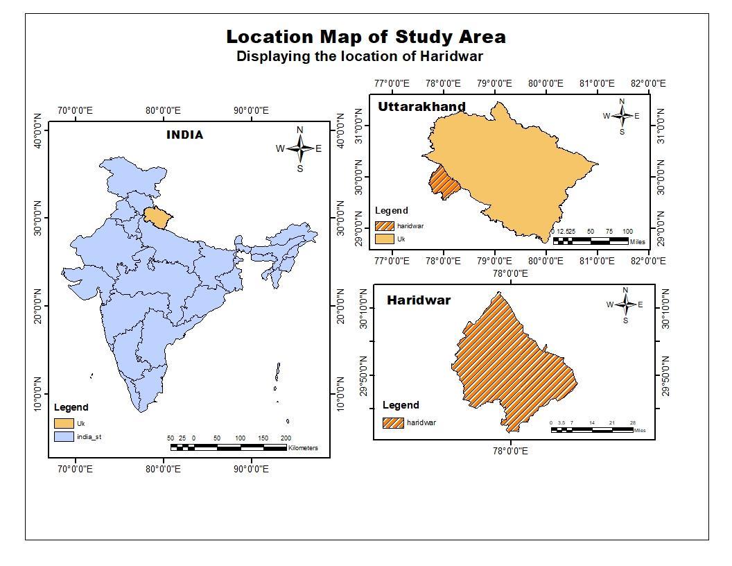
Toreducehumaneffortanderror,weusedcutting edgetechnologiessuchasUAVs,DGPS,andGIStoacquire,process,and deliverthedatalocationdata
We were able to significantly speed up the process of data collection along the holy river Ganga by using drone images, whichwillbeprocessedtoidentifypollutionhotspots,byusingUAVsandothertechnology.
Thefollowingtechnologieswereusedinthecourseofthisproject'sexecution:
A. DGPS
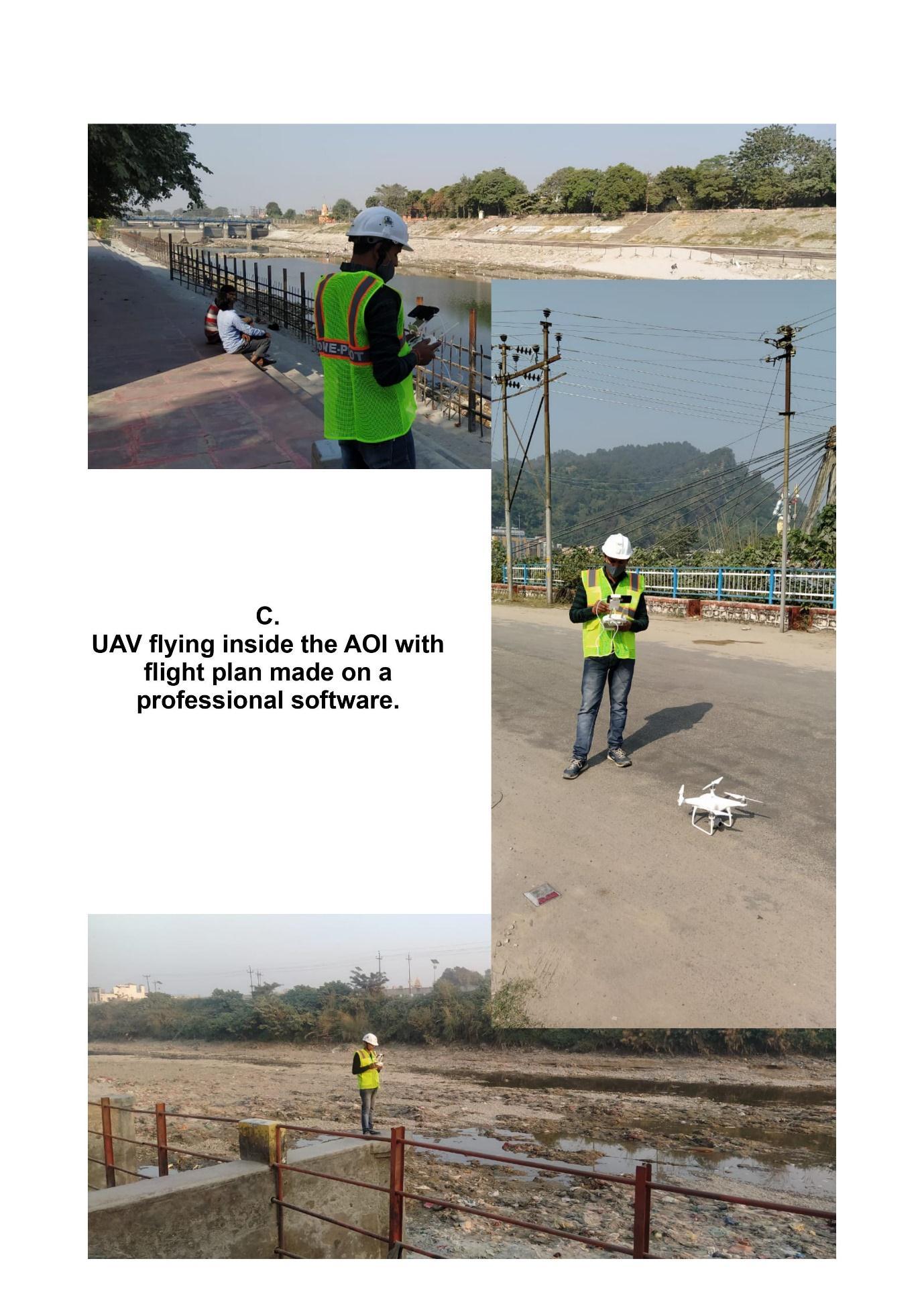
B. UAVs
C. Photogrammetry&GIS
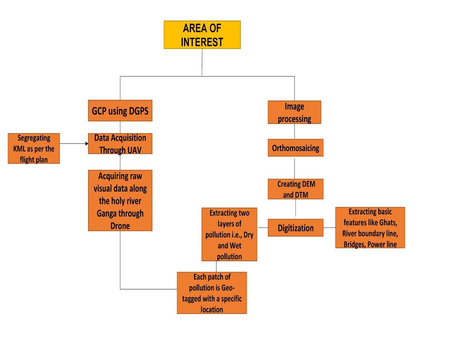
ADifferentialGlobalPositioningSystem(DGPS)isanenhancementtotheGlobalPositioningSystem(GPS)whichprovides improvedlocationaccuracy,intherangeofoperationsofeachsystem,fromthe15 meternominalGPSaccuracytoabout 1 3cmincaseofthebestimplementations.
An unmanned aerial vehicle (UAV) commonly known as a drone) is aircraft without a human pilot on board. UAVs are a componentofaUAS;whichincludeaUAV,aground basedcontroller,and asystemofcommunicationsbetweenthetwo.
International Research Journal of Engineering and Technology (IRJET) e ISSN:2395 0056
Volume: 09 Issue: 05 | May 2022 www.irjet.net p ISSN:2395 0072
The flight of UAVs may operate with various degrees of autonomy either under remote control by a human operator or autonomouslybyonboardcomputersreferredtoasanautopilot.
A geographic information system (GIS) is a conceptualized framework that provides the ability to capture and analyze spatial and geographic maps. GIS applications (or GIS apps) are computer based tools that allow the user to create interactivequeries(user createdsearches),storeandeditspatialandnonspatialdata,analyzespatialinformationoutput, andvisuallysharetheresultsoftheseoperationsbypresentingthemasmaps
Rawdata AnyImageViewer Orthomosaic QGIS KML GoogleEarthPro Digitization AutoCAD Video VLCplayer
International Research Journal of Engineering and Technology (IRJET) e ISSN:2395 0056
Volume: 09 Issue: 05 | May 2022 www.irjet.net p ISSN:2395 0072
Differential Global Positioning System (DGPS) A much more advanced form of GPS navigation that provides moreprecisepositioningthanstandardGPS.DGPSisbasedonerrorcorrectionsignalssentfromaGPSreceiverin a known location. DGPS eliminates all measurement errors in satellite ranges, allowing for highly accurate positioncalculation.
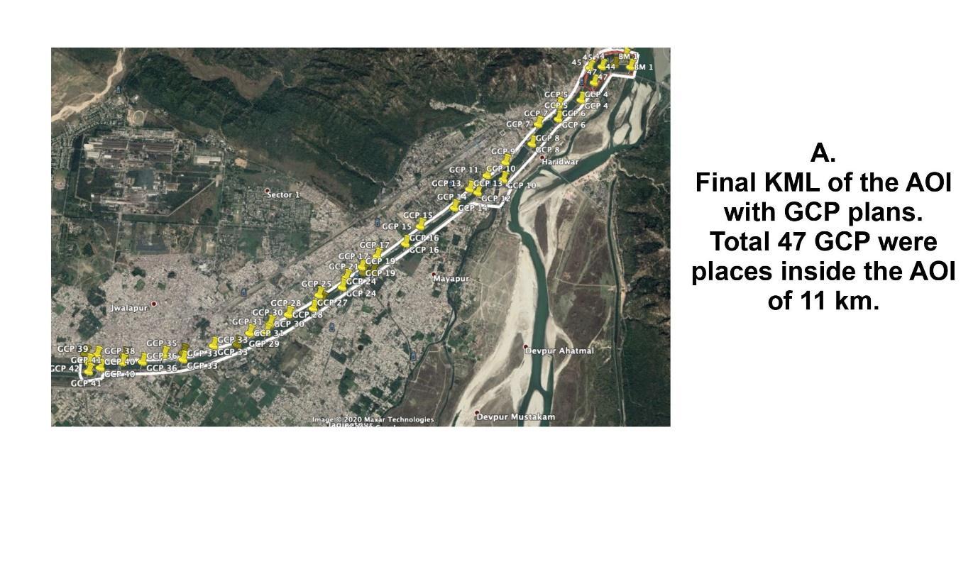
Ground Control Point (GCP) GCPsareusedfordataprocessingtoaccuratelyrefertoandcalibratetheimage.
Keyhole Markup Language (KML)- The Keyhole Markup Language (KML) is an XML notation used to express geographic annotation and visualizationin two dimensional maps and three dimensional Earth browsers. KML wascreatedtobeusedwithGoogleEarth.
Site
International Research Journal of Engineering and Technology (IRJET) e ISSN:2395 0056
Volume: 09 Issue: 05 | May 2022 www.irjet.net p ISSN:2395 0072
International Research Journal of Engineering and Technology (IRJET) e ISSN:2395 0056
Volume: 09 Issue: 05 | May 2022 www.irjet.net p ISSN:2395 0072
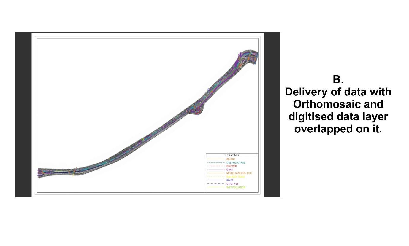
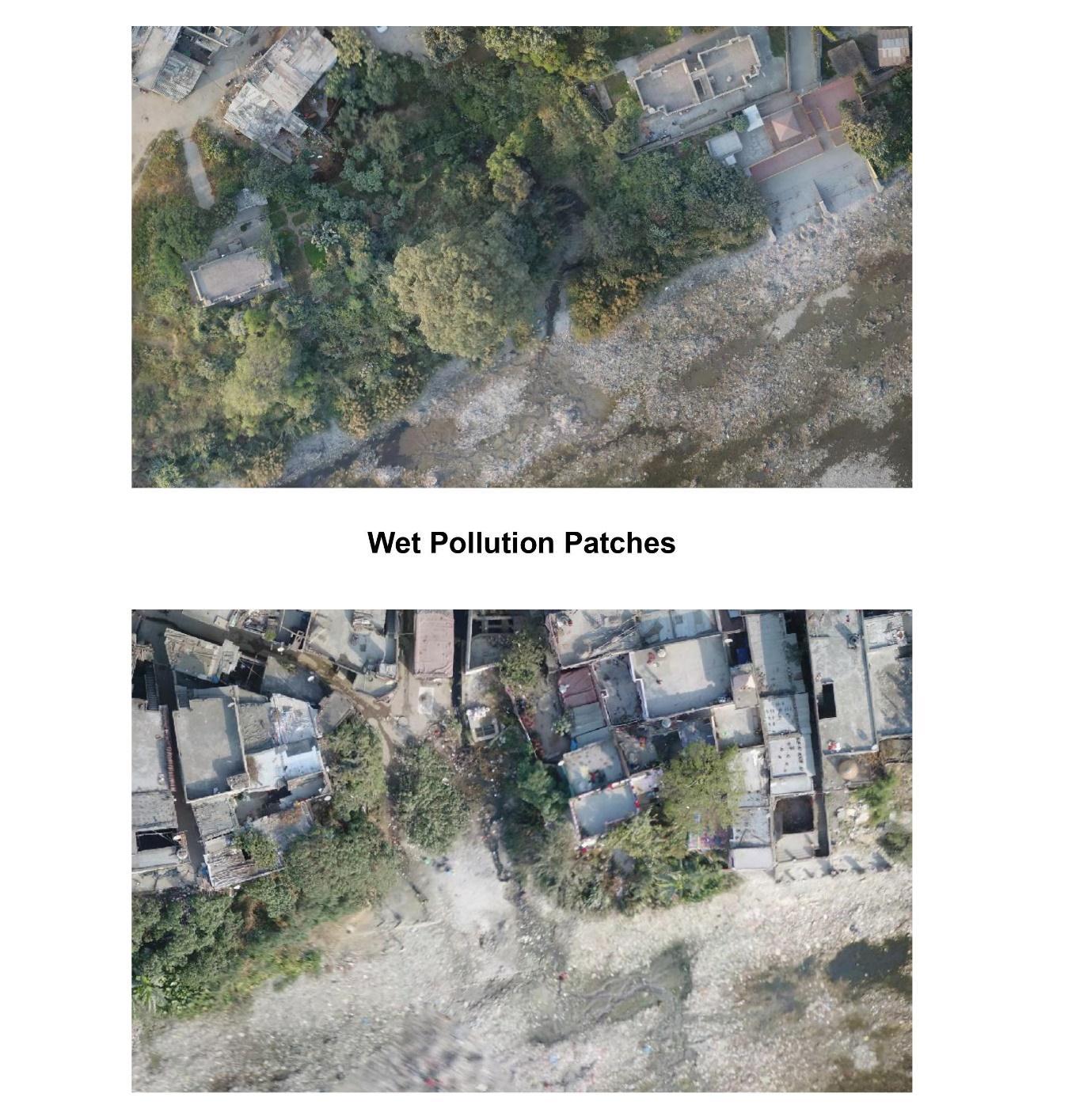
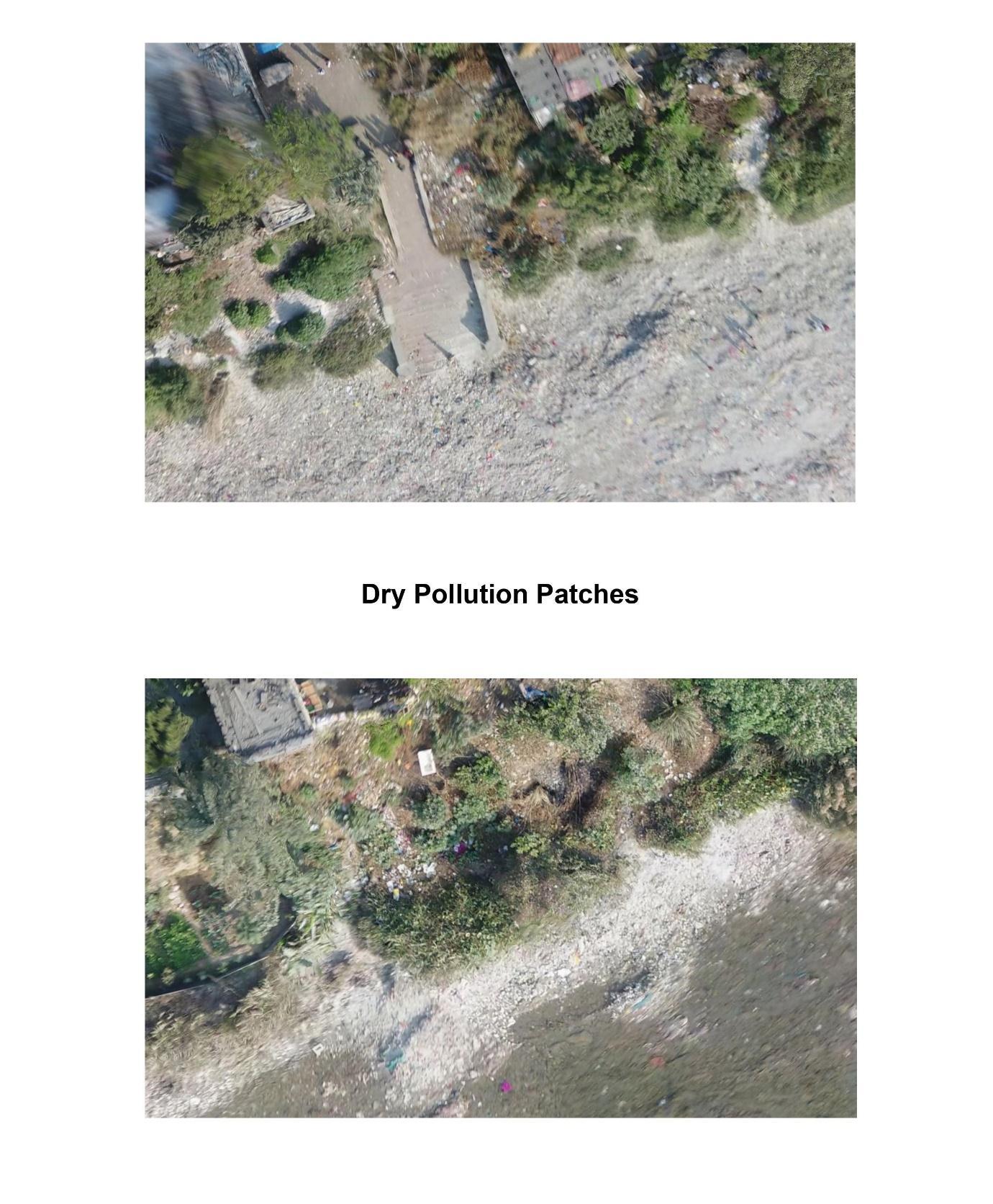
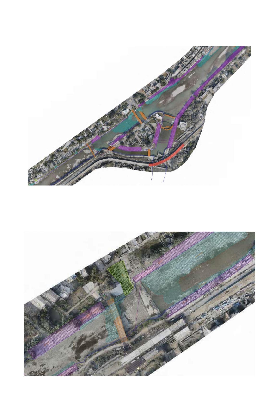
Weacquiredthemajorhotspotsofthepatchesofpollutionin theholyriverGanga, whichmaybedrywasteandanywet waste In figure6. Wetpollutionismarkedasthe ocean greenlayerinside the river. AndDrypollution is markedasthe greenlayerontheholyriver.Theresultshowshowthedomesticandindustriesletouttheirpollutionintheriver.
International Research Journal of Engineering and Technology (IRJET) e ISSN:2395 0056
Volume: 09 Issue: 05 | May 2022 www.irjet.net p ISSN:2395 0072
International Research Journal of Engineering and Technology (IRJET) e ISSN:2395 0056
Volume: 09 Issue: 05 | May 2022 www.irjet.net p ISSN:2395 0072
International Research Journal of Engineering and Technology (IRJET) e ISSN:2395 0056


Volume: 09 Issue: 05 | May 2022 www.irjet.net p ISSN:2395 0072
International Research Journal of Engineering and Technology (IRJET) e ISSN:2395 0056
Volume: 09 Issue: 05 | May 2022 www.irjet.net p ISSN:2395 0072
The current study discovered significant changes in land use and land cover in 2020. The land area covered by forests, agricultural land, plantations, stony/rocky areas, and water bodies were affected by pollution, while mines, industries, roads, built up areas, and ash fields increased. The solid and liquid pollution increases. The expansion of the developed regionhasresultedintheobliterationofwaterbodies,theholyriverispollutedbyourselvesweletoutourwasteinthe river.
Concerningthelifesupportsystemandtheforestarea,vegetationforbiologicalorganisms,industryandminemanagers, andresidentsmustfocusonprotectingtheforestandreducingairandwaterpollutioninwaterbodies.
AbdulAabid,Bisma Parveez,NagmaParveen,SherAfghanKhan,MdAbdul Rahman,JalalMohamedZayan,Omar Shabbir. “Reviews on Design and Development of Unmanned Aerial Vehicle (Drone) for Different Applications”, JournalofMechanicalEngineeringResearchandDevelopmentsISSN:1024 1752,(2022).
Amy S. Woodget, Robbie Austrums, Ian P. Maddock, Evelyn Habit. “Drones and digital photogrammetry: from classificationstocontinuumsformonitoringriverhabitatandhydromorphology”,(26April2017).
AnoopKumarShukla,ChandraShekharprasadOjha,RahulDevGarg “SurfaceWaterQualityAssessmentofGanga River Basin, India using Index Mapping”, IEEE International Geoscience and Remote Sensing Symposium, (July 2017).
Christopher Tomsett, Julian Leyland. “Remote sensing of river corridors: A review of current trends and future directions”,ReviewPaper,(31May2019).
Claude Flener, Matti Vaaja, Anttoni Jaakkola, Anssi Krooks “Seamless Mapping of River Channels at High ResolutionUsingMobileLiDARandUAV Photography”,remotesensingISSN2072 4292(2013).
Das JD, Dutta T, Saraf AK (2007) Remote sensing and GIS application in change detection of the Barak River channel,N.E.India.JIndianSocRemoteSensing35(301 312).
JavierJ.Cancela,XesúsP.González,MarVilanovaandJoséM.Mirás Avalos.“WaterManagementUsingDronesand SatellitesinAgriculture”,ThisarticlebelongstotheSpecialIssueWaterManagementUsingDronesandSatellites inAgriculture.(26April2019).
Praveen k. Thakur, Chalantika Laha, S.P. Aggarwal. “Riverbank erosion hazard study of river Ganga, upstream of FarakkabarrageusingremotesensingandGIS”,SpringerLink,(2011).
WidodoBudiharto,EdyIrwansyah,JarotS.Suroso,AndryChowanda,HeriNgarianto&AlexanderAgungSantoso Gunawan, “Mapping and 3D modelling using quadrotor drone and GIS software”, Journal of Big Data volume 8, Articlenumber:48(2021)