International Research Journal of Engineering and Technology (IRJET) e ISSN:2395 0056

Volume:09Issue:05|May2022 www.irjet.net p ISSN:2395 0072
International Research Journal of Engineering and Technology (IRJET) e ISSN:2395 0056
Volume:09Issue:05|May2022 www.irjet.net p ISSN:2395 0072
Shrikant Khedkar1, Ganesh Kolhe2, Yogesh Bajgude3, Prafull Kedar4, K.S. Patil5 .
1,2,3,4 U.G Student Civil Department, JSPM’s Imperial College of Engineering & Research, Pune, India.
5Assistance Professor Civil Department, JSPM’s Imperial College of Engineering & Research, Pune, India.
***
Abstract: - Floods are the maximum common and destructive of all forms of natural screw ups and yearly affect the lives of tens of millions all around the world. Towards this history, improved climate variability and climate trade anticipated to increase the frequency and depth of floods. There are growing demands for channel to mitigate severe rural flooding by way of impacting a huge channelling capability for extra storm runoff. This examine aims to evaluate the flooding mitigation effect of a deep channel gadget proposed on the old downtown of Kolhapur, India. With the aid of supplying a sufficient channel of a specific type of size, we will reduce the flood force at the downstream aspect for minimizing the terrible impacts of floods, regularly making the distinction between life and dying.
Key words Flood,River,Channel,Diversion,Rainfall
Rainfall extreme’s purpose flooding. Accelerated floor run off, and precipitation higher than the capability of outgoing discharge motive the water degree to upward thrust, leading to submergence of areas, particles flows/landslides, water borne health disasters, and posing threats to sustainable development. Floods effect the surroundings and society by destroyinghabitats,affectinglives,destructiveinfrastructure,andsoon.Almost40millionhectorvicinityinIndiaisflood susceptibleandevery12monthsalmosteightmillionhectoroflandisaffectedbyfloods.Apartfromthose,floodsforthe durationoftheRabiandKharifseasonsaffectthemealssecurityofthenation.Becauseofthewarmingweather,multiplied frequencyofrainfallextremesisstatedinIndia.Similarly,inrecentalongtime,thewarmingfashionovertheIndianOcean has doubtlessly more desirable moisture deliver leading to rainfall extremes within the channeling begins by way of constructingtodothispre fabricatedsectionsofmetalandurbantubearefloatedintopositionandstrategicallysunkinto theditch.
Directcontactwithwaternecessitatesacautiouswater proofingdesignacrossthejoints.
The segmental approach calls for cautious layout of the connections, in which longitudinal outcomes and forces oughttobetransferredacross.
Environmentaleffectoftheembankmentchannel.
Tostudythefloodmanagementsystem.
Topreventlackofexistenceandassetsfromflooding.
Bydivertinganexcesswaterduringhighfloodconditionfromriverbydesigningthediversionchannel.
Tofindoutthesolutionforminimizingfloodatlocation.
Tofindoutquantityofwaterdischargedfromrivertochannel
value:
International
Journal of Engineering and Technology (IRJET) e ISSN:2395 0056
p ISSN:2395 0072
Herbal screw ups are a main motive of human mortality, purpose harm to personal and public assets, deterioration of humanfitnessandenvironmental degradation.Natural catastropheimpactandcatastrophedepthare comparableacross developedanddevelopingnations,butdevelopednationshavehighercatastrophe controlandsuperiordisasterwarning systemstosaveyoutheputupandpredisastereffectascomparedtodevelopinginternationallocations.
Forgettingmoreclarityandalsotounderstandthepathofourprojectwevisitedanexpertofinthisfield.Firstly,wevisited to location with Prof. K.S. Patil, Prof. in the department & also visited Prof. S. R. Suryawanshi, department of civil engineering,ImperialCollegeofengineeringandresearch.
Forselectionofvillage,firstlywevisitedanumberofvillagesalsowevisittheir correspondingauthoritiesforthe collectionofbasicdatalikewisetotalarea,anagriculturalarea,residentialarea,avillageafterthatwecollectingthe dataofFloodimpact&alsoobservedthatconditionofthatvillageafterflood.
• Narsobawadi
• Panchganga


• Krishnariver
• Bubnal
• Ganeshwadi
We collect data from government servant Mr. Mahendra Patil sir about number of houses fully obstructed, number of houses averagely obstructed, cow sheds impacted by flood, destroyed cowsheds, number of dead animals affected agriculturalareaandresidentialarea.Andalsowevisitedthatimpactedareaforunderstandingtheactualdamage.
TotalNo.ofHouses,Cowsheds,andAnimals
International Research Journal of Engineering and Technology (IRJET) e ISSN:2395 0056
p ISSN:2395 0072
impact
An area survey is described as the gathering and amassing of statistics at the nearby degree with the aid of undertaking primary surveys. The primary surveys also are known as area surveys. Those are an important element of geographic inquiry and are executed through observation, interviews, sketching, measurement, and so on. A topographical survey, also called a land survey or topographical land survey additionally called contours. Topographical land survey measures and identifies the precise area and specifications of natural and human made capabilities within an area of land. We accumulatethemapfromGrampanchayatworkplace.Forcarryingoutsimilarlyworkwedividedthatmapinto19parts. Also, we take the market fee of the village which is a risky stage, and the warning degree that value is determined by meansofthepublicworkbranch(PWD).Withtheassistofthiscost,wecalculatedtheactualtopographyofthevillagealso wecalculated.Correspondingexcessiveflooddegreeofthatfactor.
Heavy precipitation: Precipitation of around 15 cm or more in a solitary day might be past the conveying limit of the streamandthiscausesthespillingofthe
over
banks
Rise in river bed: Becauseofhugeslopes,theHimalayanwaterwaysconveyalotofsedimentandsandwhichareatlast storedinthecatchmentregion,andonthestreambed.Siltationdiminishestheconveyinglimitofthestream.
International Research Journal of Engineering and Technology (IRJET) e ISSN:2395 0056
Volume:09Issue:05|May2022 www.irjet.net p ISSN:2395 0072
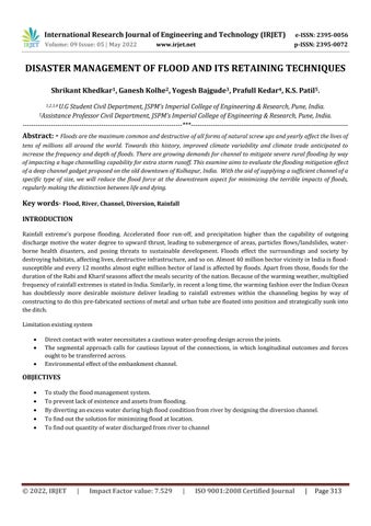
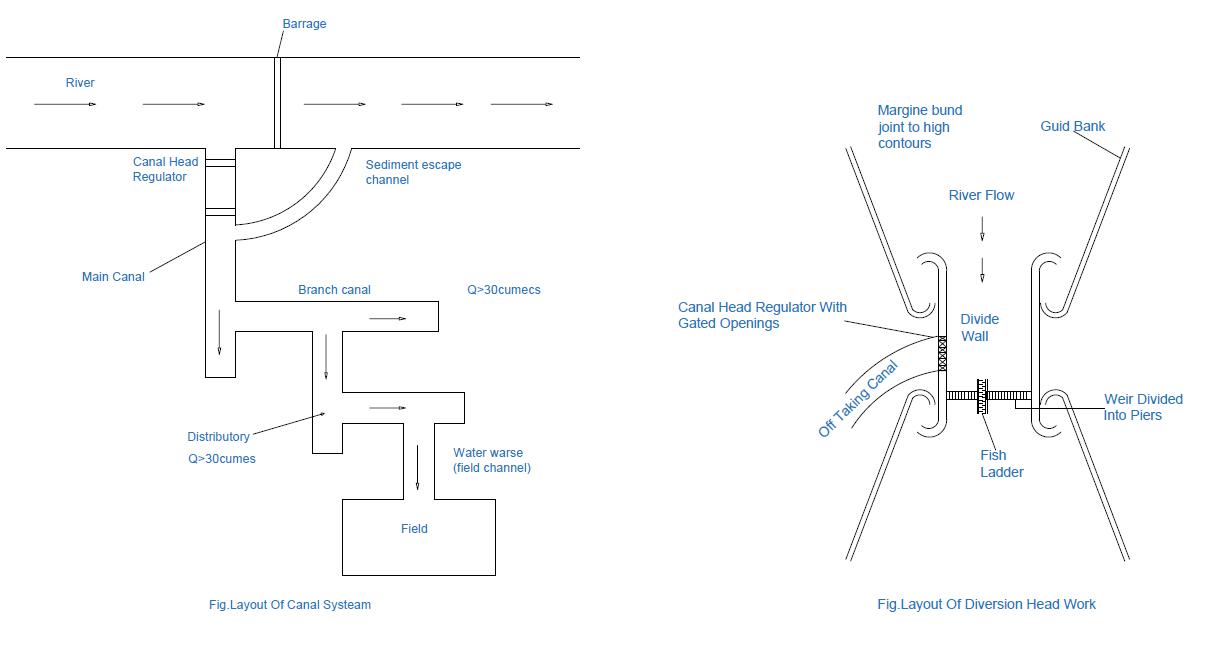
Area: LocationofthechannelfromBubnaltochannelapproximatedistancechannelwillbe10to11kmchannelisaless rainfallareawheretheirrigationanddrinkingpurposeareincomplete.
channel site: Fromthedownstreamsideofthedamfromadistanceof1km.Thefirstchannelwillbeplacedandafter every500meters,otherthreechannelswillbeprovidedfordiversionofthewatertothewestside.Andconnectandthe particularpointaroundin3km.
Sizeandshapeofthechannel: Thechannelhasatrapezoidalshapesothatwecaneasilydivertthewaterwiththeslope onthewestoftheapproximatedimension.Thechannelwillbeingroundlevel.
Control: Wewillcontrolitbymanualaswellasanautomaticsystem.thedoorsareprovidedattheopeningofthechannel.
1. Integrated Flood Management Tools Series No.19, prepared by World Meteorological Organization, Local FloodWarningSystems(LFWS)canbedividedintotwobasiccategoriesbasedonhowgaugedataiscollected,that is, either manually or automatically. In both cases the goal is to distinguish precipitation occasions that surpass limitssothereisadequateleadtimeandearlierarrangementtolimittheimpactsofthefollowing flood.Determining the most effective typeofFWS fora communityis a complicated problem. The typeofsystemused will dependon thefamiliarityofthecommunitywiththetechnologicaloptionsanditscomfortinusingthem.
2. Toward Probabilistic Prediction of Flash Flood Human Impacts (online research paper) , published by Galateia Terti,1, Isabelle Ruin , Jonathan J. Gourley
Thisarticlecentres around calculated and systemic turns of events permitting the combination of physical and social elements promptingmodelconjecturesofsituationexplicithumanmisfortunesduringablazeflood.Toarriveatthisgoal,an arbitrary backwoods classifier is applied to survey the probability of casualty event for a given situation as a componentofagentmarkers.Here,vehicle relatedsituationispickedasthewritingshowsthatmostfatalitiesfrom streakfloodingfallinthisclass.Adatabaseofflashfloodevents,withandwithouthumanlossesfrom2001to2011 intheUnitedStates,issupplementedwithothervariablesdescribingthestormevent,thespatialdistributionofthe sensitivecharacteristicsoftheexposedpopulation,andbuiltenvironmentatthecountylevel.
3. DISASTER MANAGEMENT AND PREPAREDNESS: A CASE STUDY OF UNIVERSITY OF JOS LIBRARY, Nwokedi Grace the planet earth where man lives has experienced disaster of different kinds in the course of time. Disaster whenitoccurs,canaffectbuildingssuchasschools,hospitals,shoppingmalls,factories,hotelsandworshipcentres. Disasterinmostcasesisunpredictableandtheextentofdamageequallyunpredictable
4. flood inundation modelling: A review of methods, recent advances and uncertainty analysis published by,J. Teng , A.J. Jakeman b, B.F.W. Croke (Article · April 2017) at:https://www.researchgate.net/publication/316512624 This paper reviews state of the art empirical, hydrodynamic and simple conceptual models for determining flood inundation. It explores their advantages and limitations, highlights the most recent advances and discusses future directions. It tends to how vulnerability is
© 2022, IRJET | Impact Factor value: 7.529 | ISO 9001:2008
International Research Journal of Engineering and Technology (IRJET) e ISSN:2395 0056
Volume:09Issue:05|May2022 www.irjet.net p ISSN:2395 0072
brokedowninthisfieldwiththedifferentmethodologiesanddistinguishesamazingopendoorsfortakingcareofit better. The point is to illuminate researchers new to the field, and help crisis reaction organizations, water assets administrators, insurance agency and other choice creators stay up with the latest with the most recent turns of events.
Floodsaresaidbecausethe worstherbal catastrophe in phrasesof wide varietyandcommonannual monetary loss.The chance of riverine flooding has emerged as increasingly more acute in many areas; it is on the whole caused by summer time monsoon rainfall from June to September and every so often tidal disturbances, which results in greater disastrous conditions. In truth, almost one eighth of the entire geographical place, which sums as much as 40 million hectares, is flood inclined received 25 March 2020; obtained in revised shape five July 2020; regularly occurring 6 September 2020 human beings are affected annually via riverine floods, main to economic harm as excessive as 36,004.75 million INR (imperative Water fee, 2010). Different factors which include the ineffectiveness of right flood danger management weatheralternate,andunplannedsocioeconomicdevelopmenthavebroughttothegrowingdestructivenessoffloods.
•Wecannotcontrolfloodtotallybutwecanminimizetheeffectoffloodbyusingdesigneddiversionchannel.
•Calculatedtheimpactoncrucialfacilitiesandinfrastructurefromfloodriskoccasionsinsidetheregion.
•Hence,preventthelossoflifestylesandassetsfromflooding.
•Evolvedtheplantoreducetheregionofinundationonfloodplains.
1.Haque,C.E.(2003).PerspectivesofnaturaldisastersineastandsouthAsiaandthePacificislandstates:socio economic correlatesandneedsassessment.NaturalHazards,29,465 483.
2. Bakker, M. H. N., 2004. Transboundary River Floods: Vulnerability of Continents, International River Basins and Countries.PhDDissertation,OregonStateUniversity,Corvallis.
3. Guha Sapir et al., 2004. Thirty Years of Natural Disasters 1974 2003: the Numbers. Centre for Research on the EpidemiologyofDisasters,Louvain la Neuve,p.76
4. Folke, C.(2006). "Resilience: The emergence of a perspective for socialecological systems analyses." Global environmentalchange16(3):253 267
5. Gupta, J. et al., 2010. “The adaptive capacity Wheel: a method to assess the inherent characteristics of institutions to enabletheadaptivecapacityofsociety”EnvironmentalScienceandPolicy13(6):459 471.
IRJET | Impact Factor value: 7.529
9001:2008