International Research Journal of Engineering and Technology (IRJET) e-ISSN:2395-0056 Volume: 09 Issue: 04 | Apr 2022 www.irjet.net p-ISSN:2395-0072

International Research Journal of Engineering and Technology (IRJET) e-ISSN:2395-0056 Volume: 09 Issue: 04 | Apr 2022 www.irjet.net p-ISSN:2395-0072
Department of Coastal Disaster Management, Pondicherry University, Port Blair Campus 744112, Andaman, India
Abstract: South Andaman Island is located in the southernmost part of Indian sub continent and surrounded by Bay of Bengal and Andaman Sea. This paper presents the time series analyses of the land use and land cover (LULC) of the island for the four decades of 2010, 2013, 2017 & 2020 by using multi temporal satellite data. Land use and land cover change has become a central ingredient in current strategies for managing natural resources and monitoring environmental damage. IRS LISS IV of the year 2010 and 2013, Sentinel 2A of the year 2017 and 2020 optical real time satellite data has been use for Land use and Land cover change detection. Maximum Likelihood classifier is used in the supervised classification method in this particular study. Stratified Random Sampling Method has been use to create signature file. The study area has been divided into 5 LULC classes namely Barren Land, water body, Forest, Planation and Settlement. In the year 2010 the forest covers and plantation was 68% and 8% Respectively but in the year it become 46% and 28%. Due to increasing attraction on tourism and development in hotel business in the S. Andaman Island most of the forest areas are destroying every year. Kappa coefficient method has been used to make accuracy assessment and the change shows huge change in the LULC classes. The Kappa coefficient accuracy of the LULC of the year 2010, 2013, 2017 and 2020 are 85%, 87%, 85.53% and 90% respectively. The above mentioned results indicate that there is significant change in the Land use and Land cover which made a massive impact on environment and its surrounding ecosystem. This study will help the government and EIA personnel to make better sustainable development plan.
Keywords: GIS, Supervised Classification, LULC Change detection, kappa Coefficient Statistical Analysis and Environmental Impact.
Land use and land cover change has been variously linked to several aspects of its impact on the global environment. Accordingly,landuseandlandcoverchangeshaveimpactsonsuchenvironmentalandlandscapeattributesaswaterquality, land and air resources, ecosystem and its function and the climate system itself. Land Use and Land Cover (LULC) changes haveattractedworldattentionduetoitsimportanceinglobalandregionalenvironmentalchange[6,15].TheLULCchangesof an area contemplate the assimilated product of the relation between physical environment and human activity during development [8]. In the study of land use and land cover change, it is essential that knowledge of the nature of their configuration across spatial and temporal scales is hence indispensable for sustainable environmental management and development. South Andaman Island has experienced multiple land encroachment activities and repeated deforestation, leading to extensive land use and land cover change (LULCC) during the past Three decades [2]. This research aimed at establishing the extent to which changing land use and land cover pattern has affected the coastal ecosystem and its surroundingenvironment.Thepaperhasalsobeenrevealedhowthelanddegradationandtourismmadeanegativeimpacton southAndamanIsland.
Land degradation is becoming one of the major environmental issues all over the world and affects also the Indian sub continent[13].Landdeteriorationishenceaninteractiveprocessinvolvingmanycausalfactors,amongwhichclimatechange, increasingpopulation,tourismandlandmanagementpolicyplayasignificantrole[3,5,12].Thepopulationgrowthhasledto a rapid change in land use and land cover (LULC) as a result of urbanization and increasing in attractive tourism sector. Although the changes in LULC do not directly indicate a degradation of the land, under definite circumstances, improper handlingoflanduseleadstoa“landslideeffect”thatresultsinnewproblems.IntheIslands,inappropriatedeforestation and land use practices have led to accelerated erosion, which then further contributed to flash floods in the lower plains and Landslidesinhighertopography[9].
International Research Journal of Engineering and Technology (IRJET) e-ISSN:2395-0056
Volume: 09 Issue: 04 | Apr 2022 www.irjet.net p-ISSN:2395-0072
Ancillary land degradation drivers include drought, the natural or human induced reduction in vegetation cover, poor agricultural practices determining soil organic matter losses leading to salinization, which are all factors contributing to increasethelanddegradationsensitivityofanarea[14].Inthepast,theimpactofhumanactivitiesontheS.AndamanIsland landscapeshasincreasedconsiderablycausing,amongothers,biodiversityloss,deforestation,andsoilerosion[4].
LandUse/LandCoverChangesrepresentoneofthemostimportantconsequencesoftheincreasinghumanpressureandhuge built up [1], since reflect changes in both the rural system and settlement patterns Remote sensing and Geographic Information Systems (GIS) are powerful techniques to execute accurate and timely information on the spatial distribution of LULC changes [10, 11]. Remote sensing data and GIS techniques have been utilized in legionary studies for Island land use andlandcovermappingandmonitoringinSouthAndamanIsland,India[7,16].
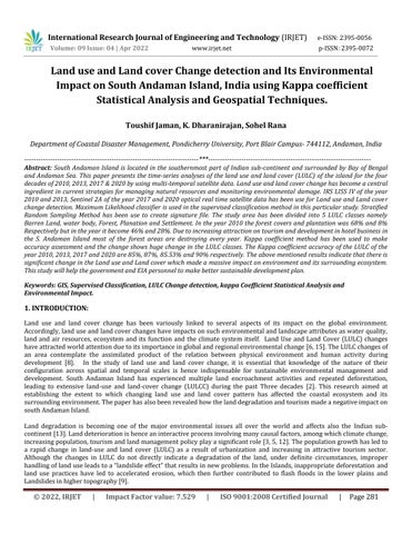
The Andaman and Nicobar groups of Islands, a union territory of India consists 572 islands among which 37 are inhabited withlandareaextendingupto8,249km2andacoastlinestretchof1,962km;theAndamanIslandsconstitute6408km2 and the Nicobar 1841 km2.The remote Andaman Islands stretches like a green and white gleaming necklace along the western edge of the Bay of Bengal, with North Andaman emerging from the Andaman Sea near the Myanmar coast and ending with Little Andaman in 10 degree Channel, that separate the archipelago from the Nicobar Island chain further South. This is the most isolated and beautiful territory of India, unspoiled and picture perfect for vacationing in paradise These two groups of island situated in the Bay of Bengal between 6°N to 13°N (740 km) and 92°E to 93°E (190 km). South Andaman Island has undulated topography with small terrain tracts and coastal low lying land, particularly the coastal areas having dense population due to their economic importance (Fig.1). Climate is tropical hot humid type with average temperature ranging from180Cto360C.ANIreceivesrainfallforeightmonthsinayearwithaveragerainfallrangingfrom3000to3500mm.
Fig.1.Study Area Map of South Andaman.

International Research Journal of Engineering and Technology (IRJET) e-ISSN:2395-0056 Volume: 09 Issue: 04 | Apr 2022 www.irjet.net p-ISSN:2395-0072
3.1.LanduseandLandcoverClassification:
InthisstudyfourdatasetsareusednamelyIRSLISSIV(IndianRemoteSensingSatellite)ofthe2010and2013withaspatial resolutionof5.6metersandSentinel2Asatellitedataoftheyear2017and2020witharesolutionof10meters (Table.1).Geo processingandimagerectificationhavebeendoneofERDASimagineGISplatform. MaximumLikelihoodclassifierisusedin the supervised classification method in this particular study. Stratified Random Sampling Method has been use to create signature file. From each stratum (LULC classes) 50 sample is collected to operate classification process. The study area has beendividedinto5LULCclasses’namelybarrenland,waterbody,forest,plantationandbuilt uparea.
Accuracy assessment is the most important aspect to assess the reliability of map. No image classification is said to be completed unless its accuracy has been assessed. Kappa coefficient statistical method has been used to make accuracy assessmentandthechangeshowshugevariationofLULCofdifferenttimeperiods.Todeterminetheaccuracyofclassification, asampleofpixelsisselectedontheclassifiedimageandtheirclassidentityiscomparedwiththegroundreferencedata.The technique used for accuracy assessment is the KAPPA analysis. KAPPA analysis is discrete multivariate technique which calculatestheproducer’sanduser’soverallaccuracy,aswellastheKappaaccuracylevel.
UserAccuracy= NumberofCorrectlyClassifiedPixelsinEachCategory TotalNumberofClassifiedPixelinthatCategory(TheRowTotal) 100
ProduserAccuracy= NumberofCorrectlyClassifiedPixelsinEachCategory TotalNumberofReferencePixelsinthatCategory(TheColumnTotal) 100
KappaCoefficient(T)= TSxTCS ∑(ColumnTotalxRowTotal) TS2 ∑(ColumnTotal RowTotal) 100
TheclassifiedimagesobtainedfromtheanalysisofmultidatedsatelliteimageriesofSouthAndamanIslandareshown.Five different land use types were classified and delineated using image interpretation technique in ERDAS 14 and ArcGIS 10.7 software. The land use pattern in the year 2010 of S. Andaman Island is barren land & sandy beach (3844.26 ha.), forest (25671.01 ha.), plantation (2838.71 ha.), settlement (3468.81 ha.) and water bodies (1896.99 ha.) (Fig2A). During 2013, the area under the land use categories are barren land & sandy beach (2245.31 ha.), forest (23095.25 ha.), plantation area (4932.36 ha.), settlement (6101.68 ha.) and water bodies (1343.45 ha.) (Fig.2B). The area under barren land & sandy beach decreases by 2245.31 ha (4%) in 2013 compare to 2010 due to increase in settlement and plantation. The forest areas also have been decreased by 7 % due to increase in built up area. The kappa coefficient statistics and overall accuracy of the classifiedimagesintheyears2010is85%and88%respectivelyandfortheyear2013itis86%and89%(Table.3)
© 2022, IRJET | Impact Factor value: 7.529 | ISO 9001:2008 Certified


International Research Journal of Engineering and Technology (IRJET) e-ISSN:2395-0056
Volume: 09 Issue: 04 | Apr 2022 www.irjet.net p-ISSN:2395-0072
Table.4: Land use and Land cover area and its change between the years 2013 & 2017
SL.NO. LULC TYPES AreainHectares 2013 AreainHectares 2017 AreaChange inHectares AreaChange InPercentage
1 BarrenLand&Beach 2245.31 1301.62 943.69 2.50%
2 Forest 23095.25 21235.01 1860.24 4.93%
3 Plantation 4932.36 7231.23 +2298.87 +6.09%
4 Settlement 6101.68 7279.07 +1177.39 +3.12%
5 WaterBody 1343.45 869.40 474.05 1.25%
The LULC pattern in the year 2017 of S. Andaman Island is barren land & sandy beach (1301.62 ha.), forest (21235.01 ha.), plantation area (7231.23 ha.), settlement (7279.07 ha.) and water bodies (869.40 ha.) (Fig.3A). In the recent year 2020 the LULCoftheIslandisbarrenland&sandybeach(453.52ha.),forest(19271.46ha.),plantationarea(8894.34ha.),settlement (8679.07 ha.) and water bodies (419.40 ha.) (Fig.3B)Between the year 2017 and 2020 the land use and land cover classification shows that the water body has been decreased by 450 ha. due to land filling of small water body, swampy and marshyareaandpressureofincreasingpopulationinthesettlementareas. TheLULCclassforestisalsodecreasedby1963.55 ha.andtheplantationareaandsettlementhasbeenincreasedby1663.11ha.and1400ha.intheyear2020compareto2017 (Table.5).Thekappacoefficientstatisticsandoverallaccuracyoftheclassifiedimagesintheyears2017is85.53%and88.57% respectively and for the year 2020 it is 90% and 88.57 %( Table.6) As one of the most beautiful tourist destinations in the country,theSouthAndamanIslandsattractthousandsoftouristseveryyeartowardsitsbeauty.Withinthelast5years,tourist influx to the ANI has double from over 2 lakh tourists in 2013 to 5 lakhs in 2018 (Directorate of tourism, 2019). Due to increaseintourism sector, thehotel and resort businessare alsoincreasing day by day.Forest, barrenland andsmall water bodiesareturningintohotels,resortsandrestaurants.
Table.5: Land use and Land cover area and its change between the years 2017 & 2020
SL.NO. LULC TYPES AreainHectares 2017 AreainHectares 2020 AreaChange inHectares AreaChange InPercentage
1 BarrenLand&Beach 1301.62 453.52 848.1 2.24% Forest 21235.01 19271.46 1963.55 5.20% Plantation 7231.23 8894.34 +1663.11 +4.40% 7279.07 8679.07 +1400 +3.71% WaterBody 869.40 419.40 450 1.19%
Table.6: Kappa Co efficient Statistics & Overall Accuracy of LULC 2017 & 2020
LULC Types
KappaCo efficientStatistics 85.53%(2017)
KappaCo efficientStatistics 90%(2020)
UserAccuracy % Producer Accuracy Accuracy Producer Accuracy% barrenland&sandybeach 85.71% 100% 87.50% 88.88% 85.71% body 100% 100% Grand Total 37721.79 ha. OverallAccuracy 88.57% OverallAccuracy 88.57%
International Research Journal of Engineering and Technology (IRJET) e-ISSN:2395-0056 Volume: 09 Issue: 04 | Apr 2022 www.irjet.net p-ISSN:2395-0072
Table.7: change between the years 2010 & 2020
SL.NO. LULC TYPES AreainHectares 2010 AreainHectares 2020 AreaChange inHectares AreaChange InPercentage
1 BarrenLand&Beach 3844.26 453.52 3390.74 8.98%
2 Forest 25671.01 19271.46 6399.55 16.96%
3 Plantation 2838.71 8894.34 +6055.63 +16.05%
4 Settlement 3468.81 8679.07 +5210.26 +13.81%
5 WaterBody 1896.99 419.40 1477.59 3.91%
The results obtained from the study confirm that IRS LISS IV and Sentinel 2A data are indeed appropriate for performing regionalscaleIlevelLULCassessments,duetoitsgoodspatialresolutionandexcellentoverallquality.Themethodologyused for the study is capable of generalizing quite well over the South Andaman Island, an area of 37721.79 ha. accurately identifying areas of Barren land, Forest, plantation, Settlement and Water Body. The environmental and ecosystem damage hasalsobeenobservedduethemanmadeactivityandgovernmentunplanneddevelopment.Therefore,itisessentialtohavea broader understanding of historical trends and identify the past drivers of environmental degradation that lead to LULC changes. In this study, we hope that the research methods designed are able to be evaluated to a level where both environmental and ecological systems can support the sustainable development of the region. The study shows that lack of management and spatial information in development projects, which may be alleviated with remote sensing data that can provideopportunitiesforperiodicalmonitoringoflanduse/landcoverchangesandtheirspatialordination.
TheauthorwouldliketothankDepartmentofCoastalDisasterManagement,PondicherryUniversity,forprovidingnecessary satellitedataandtheopportunitiestocarryouttheresearchwork. TheauthorisalsoliketoacknowledgeDr.K.Dharanirajan (ResearchSupervisor)fortheselflesssupports.TheAuthorisverymuchgracefultoSohelRanaforhishelpfulsuggestionsand Support in field study. This present study is not funded by any agency/ organization or university. To the best of our knowledge,noconflictofinterest,financialorother,exists.
1. ConacherAJ,SalaM(1998)LanddegradationinMediterraneanenvironmentsoftheworld.Wiley,Chichester
2. Darren How Jin AikI, Mohd Hasmadi Ismail , Farrah Melissa Muharam, Mohamad Azani Alias (2021) Evaluating the impactsoflanduse/landcoverchangesacrosstopographyagainstlandsurfacetemperatureinCameronHighlands. PLoS ONE16(5):e0252111.https://doi.org/10.1371/journal.pone.0252111.
3. GeistHJ,LambinEF(2004)Dynamiccausalpatternsofdesertification.Bioscience54:817 829
4. GiordanoF,MariniA(2008)Alandscapeapproachfordetectingandassessingchangesinanareapronetodesertification inSardinia(Italy).InternationalJournalofNavigationandObservation.doi:10.1155/2008/549630
5. Lambin EF, Turner BL, Geist HJ, Agbola SB, Angelsen A, Bruce JW, Coomes OT, Dirzo R, Fischer G, Folke C, George PS, HomewoodK,ImbernonJ,LeemansR,LiXB,MoranEF,MortimoreM,RamakrishnanPS,RichardsJF,SkanesH,SteffenW, StoneGD,SvedinU,VeldkampTA,VogelC,XuJC(2001)Thecausesofland useandland coverchange:movingbeyondthe myths.GlobalEnvironmentalChange:HumanandPolicyDimensions11:261 269.
6. Liu,J.,M.Liu,D.Zhuang,Z.ZhangandX.Deng(2003).Studyonspatialpatternofland usechangeinChinaduring1995 2000,ScienceinChinaSeriesD:EarthSciences,46(4),373 384.
International Research Journal of Engineering and Technology (IRJET) e-ISSN:2395-0056
Volume: 09 Issue: 04 | Apr 2022 www.irjet.net p-ISSN:2395-0072
7. Mageswaran, T., V. Sachithanandam, R. Sridhar, E. Thirunavukarasu and R. Ramesh (2015). Mapping and monitoring of land use/land cover changes in Neil Island (South Andaman) using geospatial approaches, Indian Journal of Geomarine Sciences,44(11),1762 1768.
8. Mahapatra, M., R. Ramakrishnan and A.S. Rajawat (2013). Mapping and monitoring of land use and land cover changes usingRemoteSensingandGIStechniques,InternationalJournalofGeomaticsandGeosciences,4(1),242 248.
9. Mishra PK, Rai A, Rai SC. Land use and land cover change detection using geospatial techniques in the Sikkim Himalaya, India.TheEgyptianJournalofRemoteSensingandSpaceScience.2020Aug1;23(2):133 43.
10. Rawat, J. S. and M. Kumar (2015). Monitoring land use/cover change using remote sensing and GIS techniques: A case studyofHawalbaghblock,districtAlmora,Uttarakhand,India,TheEgyptianJournalofRemoteSensingandSpaceScience, 18(1),77 84.
11. Reis,S.(2008).Analyzinglanduse/landcoverchangesusingremotesensingandGISinRize,North EastTurkey,Sensors, 8(10),6188 6202.
12. Reynolds JF, Stafford Smith M (eds) (2002) Global desertification: Do humans cause deserts?. Dahlem University Press, Berlin.
13. RommJ(2011)Desertification:thenextdustbowl.Nature478:450 451.
14. Symeonakis E, Drake N (2004) Monitoring desertification and land degradation over sub Saharan Africa. International JournalofRemoteSensing25:573 592
15. Turner,B.L.,W.C.Clark,R.W.Kates,J.F.Richard,J.T.MathewsandW.B.Meyer(1990).TheEarthasTransformedbyHuman Action. Global and Regional Changes in the Biosphere over the past 300 Years, Cambridge University Press, Cambridge, NewYork,707.
16. Yuvaraj,E.,D.K.SaravananandK.Dharanirajan(2014).AssessmentoflanduseandlandcoverchangesinSouthAndaman IslandusingremotesensingandGIS.InternationalJournalofGeomaticsandGeosciences,5,171 181.
First Author: Mr. Toushif Jaman, Research Scholar, Department of Coastal Disaster Management, PondicherryUniversity,PortBlairCampus 744112,Andaman,India
Second Author: Dr.K.Dharanirajan,AssistantProfessor, DepartmentofCoastal DisasterManagement, PondicherryUniversity,PortBlairCampus 744112,Andaman,India

Third Author: Mr. Sohel Rana, Research Scholar, Department of Coastal Disaster Management, PondicherryUniversity,PortBlairCampus 744112,Andaman,India

