Abstract Quick populace development has raised the groundwaterhelpmethodologybowl.groundwatermodel,individually.addressingexcellent,guideforthegaugedirectedtheirboundariesinformationandthickness,(i.e.,groundwaterprogressiongeographiczonesmomentumprocedures.accomplishedassetsKanpur.groundwaterassetsinterestforfinancialimprovementintheTheeconomicaladministrationofgroundwaterrequiresexactquantitativeassessment,whichcanbebyapplyinglogicalstandardsandcurrentAcoordinatedideahasbeenutilizedinthestudytodistinguishthegroundwaterexpected(GWPZs)intheKanpurutilizingremotedetecting(RS),dataframework(GIS),andlogicalorderedprocess(AHP).Forthisreason,nineeventanddevelopmentcontrollingboundarieslithology,precipitation,geomorphology,slant,wastesoil,landuse/landcover,distancetowaterway,lineamentthickness)werereadyandchangedintorasterutilizingArcGISprogramming.Thesenine(topicallayers)weredispensedloadsrelativetosignificance.Besides,theprogressivepositioningwasutilizingapairwisecorrelationlatticeoftheAHPtothelaststandardizedloadsoftheselayers.WeutilizedoverlayweightedtotalmethodtocoordinatethelayersthemakingoftheGWPZsguideofthereviewregion.Thehasbeenclassifiedintofivezones(viz.,generallygreat,moderate,poor,andextremelypoor)4,51,35,9,and1%ofthereviewregion,Atlast,forevaluatingtheadequacyofthetheGWPZsmapwasapprovedutilizingprofunditytoinformationfor99wellsconveyedovertheTheapprovalresultsaffirmthattheappliedgivesfundamentallystrongoutcomesthatcanincontextarrangingandpracticaluseoftheassetsinthiswaterfocusedonarea.
sustainable management;profundity 1.
5Assistant Professor, Dept. of Civil Engineering, Axis Institute of Technology and Management, Kanpur, Uttar Pradesh, India
2Student , B.Tech Civil Engineering, Axis Institute of Technology And Management, Kanpur, Uttar Pradesh, India
Demarcation of Ground Water Potential Zone of Kanpur City
International Research Journal of Engineering and Technology (IRJET) e ISSN: 2395 0056 Volume: 09 Issue: 03 | Mar 2022 www.irjet.net p ISSN: 2395 0072 © 2022, IRJET | Impact Factor value: 7.529 | ISO 9001:2008 Certified Journal | Page1622

Hemant Deep1 , KM. Shaifali Sen2 , Komal Tharu3 , Alka Tiwari4, Azeezurrahman Ansari5
4Student , B.Tech Civil Engineering, Axis Institute of Technology And Management, Kanpur, Uttar Pradesh, India
groundwater potential zone; analytic hierarchy process; waterstressed
1Student , B.Tech Civil Engineering, Axis Institute of Technology And Management, Kanpur, Uttar Pradesh, India
Keywords: ; GroundINTRODUCTION1.1)BACKGROUNDwaterinvestigation
in any landscape is to a great extent constrained by the pervasiveness and direction of essential and optional porosity. As such the investigation includesdepictionandplanningofvariouslithologicaland morphological units, and distinguishing quantitative
3Student , B.Tech Civil Engineering, Axis Institute of Technology And Management, Kanpur, Uttar Pradesh, India
***
boundaries of the seepage organization, soil qualities and slant of the landscape. These assume a significant part in assessinghydrologicalboundaries,whichthusempowersa comprehension of the ground water circumstance. Concentrating on every one of the boundaries in a coordinated manner works with viable ground water investigation and double dealing. These days satellite remote detecting methods are utilized for ground water investigation, particularly for depicting hydro geomorphological. Relatively few examinations have endeavored anyway to incorporate all ground water controlling boundaries. Such boundaries incorporate surfacetheTocontaminationdemonstratedcompletelyconsiderationperilousperformingtanningThecowhidegreatesteachpackintobusinessaddeddeveloped.becausearehabitatsbusinessInprocedurebeenquantitativetopography,landform,soilqualities,geographicalhighlights,morphometricattributes,andsoonGIShasviewedasquitepossiblythemostimpressiveinsurveyingtheappropriatenessoftheland.UttarPradesh,Kanpurisgreatestmechanicalandcenter.KanpurisoneofthesignificantmoderninnorthernIndia,whereinexcessof800venturesassociatedwithassembling.KanpurismostdefiledcityofenormousnumberoftanneryorganizationsisTheenormousnumberofbusinesseshasplainlytothemonetarydevelopmentofKanpur.ThetannerymushroominginnorthIndiahasgottentheriveranunloadingground.Kanpurisoneofhugetannerywithageofaround1000tonsofnaturalsubstancesday.InKanpurprincipallyRoomaregionishometocalfskintanneries,footwear,andmakerandproducts.modernareaofRoomaKanpurhavinginexcessof400industry.closeto100%ofbusinessesarechrometanningprocess.Intanningprocessspoutingdelivered,whichrequiredefiniteintreatmentofgushing.Tanneriesprocessisfoundedonchrometanning.Ithasbeenthatasolitarytannerycancauseofgroundwateraroundasweepof7to8km.1.2)OBJECTIVEgetreadydifferenttopicalguidesoftheterritoryinsidecatchmentregionlikelithology,lineament,landforms,waterbodies,wastethickness,inclineandsoils
4andeventvarietytheThecompositeguideproducedwasadditionallyarrangedbyspatialvarietyofthegroundwaterpotential.Thespatialofthepotentialdemonstratesthatgroundwaterisconstrainedbytopography,constructions,inclinelandforms..MurugesanBagyaraj(et.all)
2.LETRATUREREVIEW
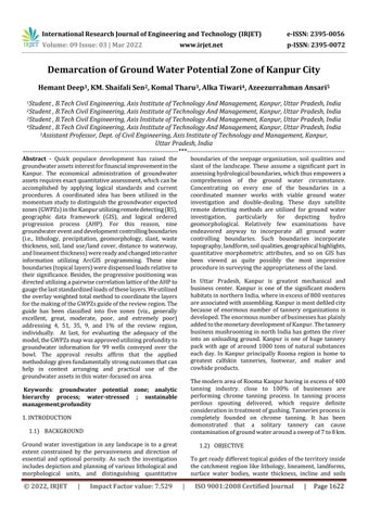
The Kanpur Nagar area lies in center of Uttar Pradesh State. It lies somewhere in the range of 25°55' and 27° North scope and 79°30' and 80°35' East. The significant pieces of the area is just about a level plain for certain minor undulations. The waterway Ganga and Yamuna with their feeders structure the waste framework. The Kanpur Nagar area is essential for Indo Gangetic Plain. The earth, residue, rock and sands of various grades are fundamental sedimentary constituents. The pre rainstorm time frame profundity to water level fluctuates from 2.20 to 27.13 mbgl though in post storm period it shifts from 2.08 to 27.13 mbgl. The profundity to water level is shallow along trench order region while it is more profound along stream Yamuna. map of study area
groundwater frameworks. Further groundwater potential review was completed in Taiwan with the assistance of 2.maps,determinevariablescover/landincorporatingremotedetectingandthegeologicaldataframework(GIS)bythefivecontributingelements:lithology,landuse,lineaments,seepage,andslant.Theloadsofaddingtothegroundwaterreenergizearedutilizingairbornephotographs,topographyalandusedataset,andfieldconfirmation.DeepeshMachiwal(et.all) [2017]; Proposed a standard approachtoportraygroundwaterpotentialzonesutilizing incorporated RS, GIS and multi rules navigation (MCDM) methods.Thesystemisshownbyacontextualinvestigation in Udaipur area of Rajasthan, western India. At first, ten topical layers have been thought of. Loads of the topical layersandtheirhighlightsthen,atthatpoint,standardized byutilizingAHP(insightfulorderprocess)MCDMstrategy andeigenvectortechnique.Atlast,thechosetopicalguides werecoordinatedbyweighteddirectblendstrategyinaGIS climatetoproduceagroundwaterpossibleguide.
location
water quality and
5.PrabirMukherjee(et.all)[2012];Madeanendeavortodecide thegroundwaterexpectedzonesinsideabone drylocaleof Kachchharea,Gujarat.Topicallayershavebeencreatedby indicatedboundaryinvestigation,Theutilizingauxiliaryinformationandadvancedsatellitepicture.potentialzoneshavebeengottenbyweightedoverlaythepositioninggivenforeveryindividualofeachtopicalguideandloadsweredoledoutasbytheirimpact.
International Research Journal of Engineering and Technology (IRJET) e ISSN: 2395 0056 Volume: 09 Issue: 03 | Mar 2022 www.irjet.net p ISSN: 2395 0072 © 2022, IRJET | Impact Factor value: 7.529 | ISO 9001:2008 Certified Journal | Page1623
[2008]:Suggestedthatevaluatingthe
iscriticalfor
groundTogroundutilizingregionsTorecognizeandportrayreasonablegroundwaterpossiblethroughcombinationofdifferenttopicalguides,GISstrategy.TofosteraGISmodeltorecognizewaterlikelyzones.showthecapacitiesofremotedetectingandGISinwaterpotentialzonesplanning.1.3)STUDYAREA
[2012]; Completedgroundwater studyintheDindigullocaleofkodaikanalslope,whichisa ruggedterritoryintheWesternGhatsofTamilnadu.Ground waterpotentialzoneshavebeendividedwiththeassistance ofremotedetectingandGeographicaldata(GIS)strategies. Alltopicalguidesareproducedutilizingtheassetsat(IRSP6 LISSIVMX)informationandInversedistanceweight(IDW) model is utilized in GIS information to distinguish the groundwater capability of the review region. For the differentgeomorphicunits,weightfactorsweredoledoutin viewoftheirabilitytostoregroundwater.
1.Cheng HawLee(et.all) expectedzoneofgroundwaterre energize the insurance of the administration of
either from remotely detected information or from informationgatheredbycustomaryreviews.
3.JobinThomas(et.all)[2011]: Decidedgroundwaterexpected zoneintropicalstreambowl(Kerala,India)utilizingremote detecting and GIS strategies. The data on geography, geomorphology,lineaments,slantandlanduse/landcover wasassembledfromLandsatETM+informationandSurvey ofIndia(SOI)toposheetsofscale1:50,000furthermore,GIS stagewasutilizedfortheincorporationofdifferenttopics.
International Research Journal of Engineering and Technology (IRJET) e ISSN: 2395 0056 Volume: 09 Issue: 03 | Mar 2022 www.irjet.net p ISSN: 2395 0072 © 2022, IRJET | Impact Factor value: 7.529 | ISO 9001:2008 Certified Journal | Page1624
3.2) RemoteSensingandGISTechniques
6. Prabhu Nath (et.all)[2014];Has told in this paper that the WQIshownthat85% ofgroundwatertestswerefound as VeryGoodtoGoodclassandcanbeusefordirectutilization while15%ofwatertestsarethePoorclassificationshows that the water isn't appropriate for direct utilization and requirestreatmentbeforeitsusage.ThehighworthofWQI groundwater.fluorides,higheratthesestationshasbeenviewedasfundamentallyfromtheupsidesofabsolutebrokenupsolids,hardness,bicarbonate,chloride,nitrateandcalciuminthe
Theprimaryerrandwastobringeveryoneofthesuitable shouldinnovations.Theseorganizations,informationsignificantinformationnaturegeographyinformationinformationhowspatialalludesconventionalguides,example,withawaterwaypolygons,spatial(HeywoodgroupedInthatonSpatialLineamentGeomorphology,Thisintroductionrasterinformation,DigitizingenlistedAssociationwasGISinformationandotherguaranteeinformationtogetherintoadataset.EveryoneoftheaccessiblespatialinformationcollectedintheInternationalScienceCongress61computerizedstructureandappropriatelytoensurethespatialpartcoversaccurately.oftherelativemultitudeofguidesandsecuritytrailedbychangeandtransformationfromtovector,gridding,cradleexamination,boxestimation,anddifferentGISprocesseswereattempted.stagedeliveredinferredlayers,forexample,Drainage,Drainagethickness,Lithology,thickness,Surfacewaterbody,Slopeandsoinformationbases,asthenameinfers,aredatasetsareadvancedtostoreandquestionspatialinformation.geographicdatascience,spatialinformationcanbeintotwosignificantclasses:vectorandrasterandCornelius,2010).Vectorinformationmodelsubstanceswithcalculationslikefocuses,lines,andandthegeographiesamongthem.Forexample,acanbeviewedasaline,andalakecanbetreatedaspolygon.Rasterinformationaddressgeologicalpeculiaritiesanetworkofmultilayereddiscretequalities,forremotedetectingpictures,examinedgeographicalandadvancedheightmodel(DEM)information.InGISsetting,spatialinformationfrequentlytospatialvectorinformation.Thepreviousphaseofdatasetinvestigationsfundamentallycentersaroundtoplacevectorinformationintodatasets,whilerasterwereasyetputawayasdocuments.Spatialcompriseofplainascribes,areas,times,anddata.Theirvariablelengthandunstructuredmakestraightforwardlytakingcareofthesewithstandarddatasetstroublesome.Extraelementsofspatialinformationincorporatehugevolumes,differentheterogeneousinformationandcomplexinformationquestionprocesses.highlightsrepresentafewdifficultiesfordatasetTheplanandexecutionofaspatialdatasetmeettheaccompanyingnecessities:
(2) This information base oughtto locally uphold spatial information types in its information model.
3.METH0D0LOGY
(4) Thisinformationbaseoughttogivespatiallists tospeedupspatialquestions.
(3) performThisdatasetshouldofferaquestionlanguagetospatialinquiries.
3.1)SpatialDatabase
Remote detecting and GIS assumes an essential part in creatingofwaterandlandassetstheexecutives.Theupside of utilizing remote detecting is to foster data on spatial
(1) This information base can be utilized for informationcapacityandtheboard.
Theseinapparatusesguidesvegetationattributes,examinationareaquestionGISforgeography,minimalGIS(Singh,recognizeFromrespectinformationoutline2009).groundwaterconnectedofzones.detectingSensingofinformationgeographgeological.puttingprogrammingapplyingThisdata(A.innovationwhichishelpfulforinvestigationandassessmentSciences,2017).RemoteSensingisthestudyofprocuringabouttheearthsurfacewithoutbeingcontactwithit.isfinishedbydetecting,recording,investigatingandthedata.GISisanassortmentofPCequipment,andgeographicinformationforcatching,away,investigating,andcontrollinginformationforForgettingthedirt,landuseandlandcover,y,geomorphology,precipitation,wastethicknesshighgoalsatellitepicturesaretakenforplanninggroundwaterzones(E.Sciences,2013).PublicRemoteAgency(NRSA)wasfirstrecognizetheremoteandGISdataforplanningofgroundwaterlikelyGISmethodisutilizedtocharacterizetheaftereffectsremotedetecting,relegatetheproperloadstotheguides.Theseguidesareutilizedtodistinguishthestream,andreenergizezones(ÆandChang,RemoteSensingandGISassumesacrucialpartinofgroundwaterpossiblezones.Fromthesatellitewecandistinguishthewaterholdinglimitwithtovariousgeomorphologicalandunderlyingunits.thelanduse,slantandprecipitationinformationwecanthegroundwaternatureofthereviewregionKumar,andChakarvarti,2015).RemoteSensingandmethodhasdemonstratedthatitisefficientcycleandexpenseforgettingslant,seepagethickness,geomorphologymaps(Sharma,2016).Ageographicdataframework(GIS)isaPCbaseddeviceplanninganddissectinghighlightoccasionsontheplanet.innovationcoordinatesnormaldatasetactivities,likeandfactualinvestigation,withmaps.GISoverseesbaseddataandgivesapparatusestoshowandofdifferentinsights,includingpopulacemonetaryimprovementopendoors,andtypes.GISpermitsyoutoconnectdatasetsandtomakedynamicshowcases.Furthermore,itgivestoenvision,question,andoverlaythosedatasetsmannersunrealisticwithconventionalbookkeepingpages.capacitiesrecognizeGISfromotherdataframeworks,
International Research Journal of Engineering and Technology (IRJET) e ISSN: 2395 0056 Volume: 09 Issue: 03 | Mar 2022 www.irjet.net p ISSN: 2395 0072 © 2022, IRJET | Impact Factor value: 7.529 | ISO 9001:2008 Certified Journal | Page1625 andmakeitsignificanttoawidescopeofpublicandprivate great,intorelegated.torasterdonesetmap.geomorphology,boundariesplanningforboundarieutilizingordercollection.toinclineandwaste,toInlikecontrast.isdynamicInsightful3.3)Remotecontrolling,informationutilizingworkmanshiparrangingundertakingsforclarifyingoccasions,foreseeingresults,andmethodologies.Remotedetectingistheandstudyofmakingestimationsoftheearthsensorsonplanesorsatellites.Thesesensorsgatheraspicturesandgivespecificabilitiestoinvestigating,andenvisioningthosepictures.detectedsymbolismiscoordinatedinsideaGIS.AnalyticalHierachicalProcessHierarchicalProcess(AHP)isamultimodelsstrategycreatedbyProfThomasLSattyin1980.ItamethodologytogetextentscalesfromcombinedThedatahasbeentakenfromgenuineestimationsloads,costandfromabstractends.thisreview,anaggregateofnineboundarieswereutilizedoutlinethegroundwaterpotentialzones,forexample,rise,thickness,topography,geomorphology,landuselandcover,lineamentanddykes,precipitationexample,andsoilsurface.DEMinformationhasbeenutilizedmakeperspectiveguide,inclineguideandstreamTheLANDSATETMpictureswereutilizedtothelandusepicture.SeepagethicknessmapismadeQGISprogrammingandloadsaredetermined.ThesesarereadyinGISclimateandloadsareallocatedeachclassesarerelegatedutilizinginsightfulcycle.Forofgroundwaterpotentialzonesabsolutelysevenareutilized,forexample,geography,seepagethickness,incline,soil,landuseThen,atthatpoint,theDEMinformationisutilizedtouptheslant,angle,guideandshapemap.DigitizingisinQGISintovectorconfigurationandconvertintothedesign.ThelogicalprogressiveinteractionisutilizedmaketopicallayersandloadsaredeterminedandThegroundwaterpotentialzonesarearrangedfiveclassesareexceptionallypoor,poor,moderate,amazing. 4.RESULTS 4.1)DRAINAGEDENSITYMAP 4.2) SLOPEMAP


5.FUTURERESULTS
To representation of the ground water possible zones different topical guides have been arranged. These incorporate land use land cover guide, lineaments and fromconcurrencelegitwasgroundguideshavestandardthickness,landformsfromsomewhatdetectedinformationandseepageinclineandsoilsfrominformationgatheredbyreviewstrategies.GroundwaterpotentialzonesbeenpartitionedbycoordinationstrategyfortopicalutilizingamodelcreatedthroughaQGISmethod.Thewaterpotentialzonesmapmadethroughthismodeldemonstratedwiththeyieldinformationtofoundtheimacyofthemodelcreatedandobservedthatitisinwiththedragwellsyieldinformationgatheredthefield.Thisshowthatthemethodologyframedhas
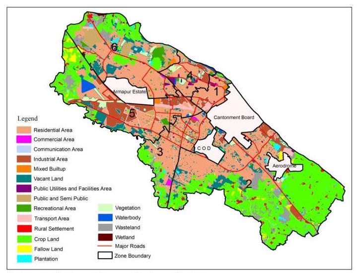
International Research Journal of Engineering and Technology (IRJET) e ISSN: 2395 0056 Volume: 09 Issue: 03 | Mar 2022 www.irjet.net p ISSN: 2395 0072 © 2022, IRJET | Impact Factor value: 7.529 | ISO 9001:2008 Certified Journal | Page1626 4.3)LINEAMENTDENSITYMAP 4.4) LULCMAP 4.5)STREAMFLOWMAP
Thevalidityofthemodeldevelopedwillbecheckedagainst the bore wells yield data which reflects the actual ground waterpotential.Thegroundwaterpotentialzonesprepared throughthismodelshowthattheexcellentpotentialzones arelocatedaroundGangariverbanks,whichcoincideswith fieldobservationofborewellsyielddatacollectedfromthe vicinity of near Ganga villages. This review will show that alsousedensity,differentusefuldisadvantagestechniquerequireseasyusedpotentialremotesensingandGISisusefultoidentifytheGroundwaterzonesinmanyways.Severalmethodologiesaretomappingofpotentialzones.Somemethodsareveryandgivesaccurateresults.Someofthemethodsmoredataandtimeconsumingprocess.Eachwillhavetheiradvantagesandtheirindoingprocess.Satelliteimageswillbeformappingofgroundwaterpotentialzonesusingparameterslikegeology,geomorphology,drainagesoil,rainfalldata,transmissivityofaquiferandland&landcover.Thediscussiononeachparameterswillbegivenformappingofpotentialzones

6.CONCLUSIONS

[3]. Jose, S. K., Jayashree, R., Kumar, R. S., & Rajendran, S. (2012). Identification of Ground Water Potential Zones in Palakkad District, Kerala Through Multicriteria Analysis TechniquesusingGeoinformationTechnology,2(1),62 68.
[4]. Kaliraj, S., Chandrasekar, N., & Magesh, N. S. (2014). Identification of potential groundwater recharge zones in Vaigaiupperbasin,TamilNadu,usingGIS basedanalytical hierarchical process (AHP) technique. Arabian Journal of Geosciences, 7(4), 1385 1401. https://doi.org/10.1007/s12517 013 0849
7.REFERENCES
[1]. Ahmed, S. A. (2016). Geospatial technology for delineating groundwater potential zones in Doddahalla watershed of Chitra Durga district , India. The Egyptian JournalofRemoteSensingandSpaceSciences,19 [2].2,223 234.https://doi.org/10.1016/j.ejrs.2016.06.002
2.Geri,D.N.,&Bharadwaj,P.(2012).StudyandMappingof Ground Water Prospect using Remote Sensing, GIS and Geoelectrical resistivity techniques a case study of Dhanbaddistrict,Jharkhand,India.Journal:IndianGeophics Union,16(2),55 63.
International Research Journal of Engineering and Technology (IRJET) e ISSN: 2395 0056 Volume: 09 Issue: 03 | Mar 2022 www.irjet.net p ISSN: 2395 0072 © 2022, IRJET | Impact Factor value: 7.529 | ISO 9001:2008 Certified Journal | Page1627
advantageandcanbeeffectivelyutilized somewhereelse with fitting control. The above study has connoted the capacities of involving remote detecting information and topographical data frameworks for recognizable proof of various ground water expected zones, particularly in differentlandsetup.